Local Government
Cunderdin
Region
Wheatbelt
Cunderdin
Cunderdin
Wheatbelt
Constructed from 1890
| Type | Status | Date | Documents |
|---|---|---|---|
| (no listings) |
| Type | Status | Date | Documents |
|---|---|---|---|
| (no listings) |
| Type | Status | Date | Grading/Management | |
|---|---|---|---|---|
| Category | ||||
| Municipal Inventory | Adopted | 31 Dec 1996 | 4 | |
Historic site
| Epoch | General | Specific |
|---|---|---|
| Original Use | GOVERNMENTAL | Reservoir or Dam |
| Present Use | GOVERNMENTAL | Reservoir or Dam |
| Type | General | Specific |
|---|---|---|
| Wall | STONE | Other Stone |
| General | Specific |
|---|---|
| SOCIAL & CIVIC ACTIVITIES | Community services & utilities |
This information is provided voluntarily as a public service. The information provided is made available in good faith and is derived from sources believed to be reliable and accurate. However, the information is provided solely on the basis that readers will be responsible for making their own assessment of the matters discussed herein and are advised to verify all relevant representations, statements and information.
(The following discusses the time when an important party, headed by the Premier, came to Cunderdin in May 1902. Note also at the end of the extract information on the GWS Caretaker's Cottage)- (ref; p-45 JP Stokes) "...After touring the building (pumping station), the party moved to the 12 million gallon dam about three quarters of a mile south of the pumping station: It was originally one of the big railway tanks constructed along the Yilgarn railway line. This tank has a fine catchment, draining as it does the Cunderdin Hills. When the party arrived at the dam it had 23 feet of water in it, representing 10,000,000 gallons. Mr Leake and Mr Rason walked along the jetty and got into the boat moored at ots end and had a pull on the fine freah water lake..." As indicated above, Cunderdin Hill was associated with the storage of water long before the establishment of the dam for the water scheme. The first dam, built before 1893, serviced the Yilgarn Railway. It's catchment was an extensive granite cap on land later owned by Paul Howitt, whose catchment is a low wall of granit slabs skilfully intermarried and standing as sturdily as when they were first laid almost a hundred years ago. From the catchment, water was directed by means of a tunnel, sufficiently large enough for a man to stand upright, through a hill to the old railway dam. Spoil from the tunnel, over half a mile long, may still be seen as a series of mounds between the catchment and the dam. It is said that Chinese labourers were employed in the tedious work of constructing the tunnel, which in part went theough solid granite. Although the tunnel is now closed, the entrance may still be viewed through an iron grille.. Nearby a two roomed cottage later used by Cunderdin golfers for their buggies. Built before 1900, it was the caretaker's cottage. In the early 1900's the Simpson family consisting of W Blythe Simpson, his wife and four children, Rose, JIm , Tom and May lived in the cottage. They had a fine vegetable garden near the dam and Simpson Senior was forever mending the water pipes with red lead.
| Ref ID No | Ref Name | Ref Source | Ref Date |
|---|---|---|---|
| JP Stokes;"Cunderdin- Meckering: A Wheatlands History". p: 45 | Melbourne | 1986 |
| Owner | Category |
|---|---|
| Mr & Mrs L Bacon | Other Private |
This information is provided voluntarily as a public service. The information provided is made available in good faith and is derived from sources believed to be reliable and accurate. However, the information is provided solely on the basis that readers will be responsible for making their own assessment of the matters discussed herein and are advised to verify all relevant representations, statements and information.
Cunderdin
Cunderdin
Wheatbelt
Constructed from 1940
| Type | Status | Date | Documents |
|---|---|---|---|
| (no listings) |
| Type | Status | Date | Documents |
|---|---|---|---|
| RHP - Does not warrant assessment | Current | 29 Apr 2005 |
| Type | Status | Date | Grading/Management | |
|---|---|---|---|---|
| Category | ||||
| (no listings) | ||||
Building Inspection from 1999 indicated that it was in poor condition.
Individual Building or Group
| Epoch | General | Specific |
|---|---|---|
| Original Use | HEALTH | Housing or Quarters |
| Present Use | VACANT\UNUSED | Vacant\Unused |
| Style |
|---|
| Vernacular |
| Type | General | Specific |
|---|---|---|
| Roof | METAL | Corrugated Iron |
| Wall | TIMBER | Weatherboard |
| Wall | ASBESTOS | Fibrous Cement, flat |
| General | Specific |
|---|---|
| SOCIAL & CIVIC ACTIVITIES | Community services & utilities |
This information is provided voluntarily as a public service. The information provided is made available in good faith and is derived from sources believed to be reliable and accurate. However, the information is provided solely on the basis that readers will be responsible for making their own assessment of the matters discussed herein and are advised to verify all relevant representations, statements and information.

82 Aerodrome Rd Cunderdin
108 - Bellman Hangar 101, 104, 110, 111, 112, 113 & 114 - huts related to flying operations or training 1, 106 & 109 - ancillary buildings
Bellman Hangar and associated Buildings
RAAF Station (fmr)
Cunderdin
Wheatbelt
Constructed from 1940
| Type | Status | Date | Documents |
|---|---|---|---|
| State Register | Registered | 20 Sep 2002 | HCWebsite.Listing+ListingDocument, HCWebsite.Listing+ListingDocument |
| Type | Status | Date | Documents |
|---|---|---|---|
| (no listings) |
| Type | Status | Date | Grading/Management | |
|---|---|---|---|---|
| Category | ||||
| Classified by the National Trust | Classified | 10 Jun 1996 | ||
Reasonable condition
| Library Id | Title | Medium | Year Of Publication |
|---|---|---|---|
| 7815 | A memorial to no. 16 course: empire air training scheme, June 1941 - March 1942. | Other | 1995 |
| 4073 | Conservation Plan for the Cunderdin Airfield | Heritage Study {Cons'n Plan} | 1999 |
| 4379 | Conservation Plan for the Former RAAF Motor Transport Garage and Office Cunderdin Airfield | Heritage Study {Cons'n Plan} | 1999 |
Individual Building or Group
| Epoch | General | Specific |
|---|---|---|
| Original Use | Transport\Communications | Air: Hangar |
| Original Use | Transport\Communications | Air: 0ffice or Administration Bldg |
| Present Use | MILITARY | Other |
| Original Use | MILITARY | Other |
| Style |
|---|
| Other Style |
| Type | General | Specific |
|---|---|---|
| Wall | TIMBER | Weatherboard |
| Other | TIMBER | Other Timber |
| Other | METAL | Steel |
| Wall | ASBESTOS | Fibrous Cement, flat |
| Roof | ASBESTOS | Fibrous Cement, corrugated |
| General | Specific |
|---|---|
| OUTSIDE INFLUENCES | World Wars & other wars |
| DEMOGRAPHIC SETTLEMENT & MOBILITY | Government policy |
| OUTSIDE INFLUENCES | Refugees |
| TRANSPORT & COMMUNICATIONS | Air transport |
| DEMOGRAPHIC SETTLEMENT & MOBILITY | Settlements |
This information is provided voluntarily as a public service. The information provided is made available in good faith and is derived from sources believed to be reliable and accurate. However, the information is provided solely on the basis that readers will be responsible for making their own assessment of the matters discussed herein and are advised to verify all relevant representations, statements and information.

Cnr Bedford & Donovan Sts Cunderdin
Cunderdin
Wheatbelt
Constructed from 1922
| Type | Status | Date | Documents |
|---|---|---|---|
| (no listings) |
| Type | Status | Date | Documents |
|---|---|---|---|
| (no listings) |
| Type | Status | Date | Grading/Management | |
|---|---|---|---|---|
| Category | ||||
| Municipal Inventory | Adopted | 31 Dec 1996 | 2 | |
| Catholic Church Inventory | Adopted | 01 Jul 1998 | ||
| Name | Type | Year From | Year To |
|---|---|---|---|
| E. Henderson | Architect | - | - |
Individual Building or Group
| Epoch | General | Specific |
|---|---|---|
| Original Use | RELIGIOUS | Church, Cathedral or Chapel |
| Present Use | RELIGIOUS | Church, Cathedral or Chapel |
| Type | General | Specific |
|---|---|---|
| Wall | BRICK | Common Brick |
| General | Specific |
|---|---|
| SOCIAL & CIVIC ACTIVITIES | Religion |
This information is provided voluntarily as a public service. The information provided is made available in good faith and is derived from sources believed to be reliable and accurate. However, the information is provided solely on the basis that readers will be responsible for making their own assessment of the matters discussed herein and are advised to verify all relevant representations, statements and information.
Constructed from 1922
"The church is a brick construction on a solid stone foundation, which occupies a commanding site and is a worthy addition to the architecture of the town, which already possesses some very attractive and substantial public and residential buildings. Mr E le B Henderson of Perth was architect and Mr JK Moore Contractor." (ref-Northam ADvertiser 3rd May 1922)
In 1910, Father O'Reilly of the Roman Catholic Church applies for Lot 14 (granted). In 1914 Father O'Reilly applies for Lot 10 instead of 14 (denied). This application was amended in 1915 to Lots 66 & 65 (denied) Lots 73 & 74 on the basis that the grounds were better. In Decemeber that year, land was granted to comprise lots 73 and 74 in lieu of Lot 14. Lots 71 & 72 were granted for a playground for the attached school, this was later amended to Lots 71 & 74. The church opened on Sunday 7th May 1922, it was built at a cost of 1600 pounds was designed by E Henderson and built by JK Moore. It was opened by Dr PJ Clune. A century old bell first used in the Millitary Barracks Perth which was brought oto Northam purchased by Father Linnane for the new Cunderdin Church. At the start of the project, the building committee had 560 pounds and borrowed over 1000 pounds. Contract price of Church- 1350 pounds Furnishings- 100 pounds Fencing Material- 15 pounds Architect's Fee- 93 pounds Land 16 pounds 10 shillings Total- 1574 pounds 10 shillings.
| Ref ID No | Ref Name | Ref Source | Ref Date |
|---|---|---|---|
| 14980/10 | DOLA p 4,11,26,30,33 | 1910-1915 | |
| Government Gazette;"Reserve 13333 amended to Lots 73 & 74". p 3798 | 10-12-1915 | ||
| Government Gazette;"Lot 14- Church site". p 1089 | 24-3-1911 | ||
| Government Gazette;"Reserve 13333 amended to Lots 71 & 74". p 912 | 29-6-1934 | ||
| JP Stokes;"Cunderdin-Meckering: A Wheatlands History". pp 92,93,172,234 | 1986 | ||
| Northam Advertiser;"CAtholic Church at Cunderdin" p 3 | 10-5-1922 |
| Owner | Category |
|---|---|
| Catholic Church | Church Property |
This information is provided voluntarily as a public service. The information provided is made available in good faith and is derived from sources believed to be reliable and accurate. However, the information is provided solely on the basis that readers will be responsible for making their own assessment of the matters discussed herein and are advised to verify all relevant representations, statements and information.
Cnr Bedford & Pemberton St Cunderdin
Cunderdin
Wheatbelt
Constructed from 1954
| Type | Status | Date | Documents |
|---|---|---|---|
| (no listings) |
| Type | Status | Date | Documents |
|---|---|---|---|
| (no listings) |
| Type | Status | Date | Grading/Management | |
|---|---|---|---|---|
| Category | ||||
| Uniting Church Inventory | Completed | 01 Oct 1996 | ||
Individual Building or Group
| Epoch | General | Specific |
|---|---|---|
| Present Use | RELIGIOUS | Church, Cathedral or Chapel |
| Original Use | RELIGIOUS | Church, Cathedral or Chapel |
| Original Use | RELIGIOUS | Church Hall |
| Present Use | RELIGIOUS | Church Hall |
| Type | General | Specific |
|---|---|---|
| Roof | TILE | Ceramic Tile |
| Wall | BRICK | Common Brick |
| General | Specific |
|---|---|
| SOCIAL & CIVIC ACTIVITIES | Religion |
This information is provided voluntarily as a public service. The information provided is made available in good faith and is derived from sources believed to be reliable and accurate. However, the information is provided solely on the basis that readers will be responsible for making their own assessment of the matters discussed herein and are advised to verify all relevant representations, statements and information.
2 Egeberg St Cunderdin
Cunderdin
Wheatbelt
Constructed from 1960
| Type | Status | Date | Documents |
|---|---|---|---|
| (no listings) |
| Type | Status | Date | Documents |
|---|---|---|---|
| (no listings) |
| Type | Status | Date | Grading/Management | |
|---|---|---|---|---|
| Category | ||||
| Uniting Church Inventory | Completed | 01 Oct 1996 | ||
Individual Building or Group
| Epoch | General | Specific |
|---|---|---|
| Present Use | RELIGIOUS | Housing or Quarters |
| Original Use | RELIGIOUS | Housing or Quarters |
| Type | General | Specific |
|---|---|---|
| Roof | TILE | Ceramic Tile |
| Wall | BRICK | Common Brick |
| General | Specific |
|---|---|
| SOCIAL & CIVIC ACTIVITIES | Religion |
This information is provided voluntarily as a public service. The information provided is made available in good faith and is derived from sources believed to be reliable and accurate. However, the information is provided solely on the basis that readers will be responsible for making their own assessment of the matters discussed herein and are advised to verify all relevant representations, statements and information.

Cnr Forrest & Donovan Sts Cunderdin
Cunderdin
Wheatbelt
Constructed from 1935
| Type | Status | Date | Documents |
|---|---|---|---|
| (no listings) |
| Type | Status | Date | Documents |
|---|---|---|---|
| (no listings) |
| Type | Status | Date | Grading/Management | |
|---|---|---|---|---|
| Category | ||||
| Anglican Church Inventory | YES | 31 Jul 1996 | ||
| Municipal Inventory | Adopted | 31 Dec 1996 | 3 | |
Individual Building or Group
| Epoch | General | Specific |
|---|---|---|
| Original Use | RELIGIOUS | Church, Cathedral or Chapel |
| Present Use | RELIGIOUS | Church, Cathedral or Chapel |
| Type | General | Specific |
|---|---|---|
| Wall | (none) | |
| Roof | (none) |
| General | Specific |
|---|---|
| SOCIAL & CIVIC ACTIVITIES | Religion |
This information is provided voluntarily as a public service. The information provided is made available in good faith and is derived from sources believed to be reliable and accurate. However, the information is provided solely on the basis that readers will be responsible for making their own assessment of the matters discussed herein and are advised to verify all relevant representations, statements and information.
An application was first made for Reserve 2909 by Rev RH Moore for land for a church in 1906. This site is approved in 1907 by the Minister for Lands. in 1920, the Diocesan Secretary saw lot 65,66 or 67(corner block) as more appropriate for a church to USL. USL does not approve. In 1922, Norman L Hodgson (Meckering Roads Board) applies to USL for lot 65 & 66 and the church applies for Lot 67. This is approved by USL even though only one lot can be granted and the Catholic Church had been granted two lots and purchased a third. This was granted as a 999 year lease.
| Ref ID No | Ref Name | Ref Source | Ref Date |
|---|---|---|---|
| Government Gazette;"Reserve 10702 amended to Lot 66". p 221 | 11-2-1921 | ||
| AN3/11, Acc 1590, Box 7 | DOLA File/State Archives. pp 1,3,14,18,20,26 | ||
| Cunderdin-Meckering-Tammin Mail. p1 | 23-3-1935 | ||
| Government Gazette;"Reserve 10702 amended to inc Lot 65 & 66". p 2170 | 21-11-1922 | ||
| Government Gazette;"Reserve 10702". p 1043 | 5-5-1907 |
| Owner | Category |
|---|---|
| Anglican Church of Cunderdin | Church Property |
This information is provided voluntarily as a public service. The information provided is made available in good faith and is derived from sources believed to be reliable and accurate. However, the information is provided solely on the basis that readers will be responsible for making their own assessment of the matters discussed herein and are advised to verify all relevant representations, statements and information.

Forrest St Cunderdin
Lodge Room
Cunderdin
Wheatbelt
Constructed from 1920
| Type | Status | Date | Documents |
|---|---|---|---|
| (no listings) |
| Type | Status | Date | Documents |
|---|---|---|---|
| (no listings) |
| Type | Status | Date | Grading/Management | |
|---|---|---|---|---|
| Category | ||||
| Municipal Inventory | Adopted | 31 Dec 1996 | 3 | |
Individual Building or Group
| Epoch | General | Specific |
|---|---|---|
| Present Use | SOCIAL\RECREATIONAL | Masonic Hall |
| Original Use | SOCIAL\RECREATIONAL | Masonic Hall |
| Type | General | Specific |
|---|---|---|
| Roof | METAL | Corrugated Iron |
| Wall | BRICK | Common Brick |
| General | Specific |
|---|---|
| SOCIAL & CIVIC ACTIVITIES | Institutions |
This information is provided voluntarily as a public service. The information provided is made available in good faith and is derived from sources believed to be reliable and accurate. However, the information is provided solely on the basis that readers will be responsible for making their own assessment of the matters discussed herein and are advised to verify all relevant representations, statements and information.
Constructed from 1924
The Cunderdin Masonic Lodge was established in ____, but by 1923, the lodge was making applications for a building scheme for a more suitable building. By Dec 1923 plans for a new building were submitted and approved by the Grand Superintendant for Works. The Memorial Stone was unveiled in March 1924 by Archbishop Reiley to mark the completion of the New Masonic Hall.
Additions made in 1960 include internal toilets.
| Ref ID No | Ref Name | Ref Source | Ref Date |
|---|---|---|---|
| R & H Mussared;"A Brief History of the Cunderdin Masonic Lodge". p 94 & 231 | |||
| West Australian;"p 4 | 12-3-1924 | ||
| West Australian;"p 12 | 12-8-1923 | ||
| West Australian;"p 9 | 12-7-1923 | ||
| West Australian;"p 4 | 12-12-1923 |
| Owner | Category |
|---|---|
| Cunderdin Masonic Lodge | Inc. Non-profit body |
This information is provided voluntarily as a public service. The information provided is made available in good faith and is derived from sources believed to be reliable and accurate. However, the information is provided solely on the basis that readers will be responsible for making their own assessment of the matters discussed herein and are advised to verify all relevant representations, statements and information.
Forrest St Cunderdin
Cunderdin Museum
Cunderdin
Wheatbelt
Constructed from 1901 to 1902
| Type | Status | Date | Documents |
|---|---|---|---|
| State Register | Registered | 02 Jul 1999 | HCWebsite.Listing+ListingDocument, HCWebsite.Listing+ListingDocument |
| Type | Status | Date | Documents |
|---|---|---|---|
| (no listings) |
| Type | Status | Date | Grading/Management | |
|---|---|---|---|---|
| Category | ||||
| Classified by the National Trust | Classified | 02 Sep 1974 | ||
| Register of the National Estate | Permanent | 21 Mar 1978 | ||
| Municipal Inventory | Adopted | 31 Dec 1996 | 1 | |
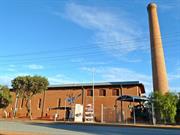
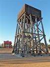
16610 Goldfields Water Supply Scheme
| Library Id | Title | Medium | Year Of Publication |
|---|---|---|---|
| 3680 | Conservation plan for No. 3 Pumping Station, Cunderdin. | Heritage Study {Cons'n Plan} | 1998 |
| 3860 | No 3 Pumping Station Cunderdin Conservation Works Final Report | Heritage Study {Other} | 1999 |
Individual Building or Group
| Epoch | General | Specific |
|---|---|---|
| Original Use | GOVERNMENTAL | Pumping Station |
| Present Use | EDUCATIONAL | Museum |
| Original Use | Transport\Communications | Water: Other |
| Style |
|---|
| Federation Warehouse |
| Type | General | Specific |
|---|---|---|
| Roof | METAL | Corrugated Iron |
| Wall | BRICK | Common Brick |
| General | Specific |
|---|---|
| SOCIAL & CIVIC ACTIVITIES | Community services & utilities |
| TRANSPORT & COMMUNICATIONS | Technology & technological change |
| DEMOGRAPHIC SETTLEMENT & MOBILITY | Technology & technological change |
This information is provided voluntarily as a public service. The information provided is made available in good faith and is derived from sources believed to be reliable and accurate. However, the information is provided solely on the basis that readers will be responsible for making their own assessment of the matters discussed herein and are advised to verify all relevant representations, statements and information.
One of eight stations between Mundaring Weir and Coolgardie, basic operation of the scheme started in 1903. Associated with Engineer in Chief, C Y O'Connor. Important landmark of Cunderdin and emphasises the link with goldfields and with water supply. Has been restored for use as the historical museum of the district and will thus continue to ply its part in the community life.
large red brick building used to house steam pumps used in the Goldfields water scheme. Has a 100 ft brick chimney, made of curved bricks. Building now used as a museum. Situated on Great Eastern Highway in the Cunderdin town site.
Assessment 1974 Architect/builder unknown - Public Works Office Construction circa 1902
This information is provided voluntarily as a public service. The information provided is made available in good faith and is derived from sources believed to be reliable and accurate. However, the information is provided solely on the basis that readers will be responsible for making their own assessment of the matters discussed herein and are advised to verify all relevant representations, statements and information.
| Owner | Category |
|---|---|
| Vested in the Shire of Cunderdin | Local Gov't |
This information is provided voluntarily as a public service. The information provided is made available in good faith and is derived from sources believed to be reliable and accurate. However, the information is provided solely on the basis that readers will be responsible for making their own assessment of the matters discussed herein and are advised to verify all relevant representations, statements and information.
Lot 2 Forrest St Cunderdin
Near Museum ex 3 pumping station
Cunderdin
Wheatbelt
Constructed from 1906 to 1994
| Type | Status | Date | Documents |
|---|---|---|---|
| State Register | Registered | 28 Aug 2001 | HCWebsite.Listing+ListingDocument, HCWebsite.Listing+ListingDocument |
| Type | Status | Date | Documents |
|---|---|---|---|
| (no listings) |
| Type | Status | Date | Grading/Management | |
|---|---|---|---|---|
| Category | ||||
| Statewide Lge Timber Str Survey | Completed | 11 Dec 1998 | ||
| Classified by the National Trust | Classified | 05 Sep 1983 | ||
| Register of the National Estate | Permanent | 25 Mar 1986 | ||
| Municipal Inventory | Adopted | 31 Dec 1996 | 2 | |
16610 Goldfields Water Supply Scheme
The stand for the square iron tank is of wood with its supporting members being round timber poles. It was erected in 1906, after the pipeline carrying water to Kalgoorlie was opened in 1903, and No 3 pumping station (now Cunderdin Historical Museum) is nearby. It is no longer in use but the main structure is sound. The tank holds approximatesly 59 kilolitres and the stand measures at base 8.6m x 8.4m (R Campbell).
| Name | Type | Year From | Year To |
|---|---|---|---|
| WA Government Railways | Architect | - | - |
Historic site
| Epoch | General | Specific |
|---|---|---|
| Original Use | Transport\Communications | Rail: Water Tower |
| Present Use | Transport\Communications | Rail: Water Tower |
| Type | General | Specific |
|---|---|---|
| Other | TIMBER | Other Timber |
| General | Specific |
|---|---|
| TRANSPORT & COMMUNICATIONS | Rail & light rail transport |
This information is provided voluntarily as a public service. The information provided is made available in good faith and is derived from sources believed to be reliable and accurate. However, the information is provided solely on the basis that readers will be responsible for making their own assessment of the matters discussed herein and are advised to verify all relevant representations, statements and information.
Historically important as part of the water supply for locomotives on the original railway line from Perth to Kalgoorlie and few if any others have survived. It is esteemed locally as a feature of the town
Assessment 1983 Construction circa 906 Timber tank stand supporting members being round wooden poles, square iron tank. Capacity approx 59 kilolitres, base of stand 8.6m x x8.4 m
This information is provided voluntarily as a public service. The information provided is made available in good faith and is derived from sources believed to be reliable and accurate. However, the information is provided solely on the basis that readers will be responsible for making their own assessment of the matters discussed herein and are advised to verify all relevant representations, statements and information.
| Owner | Category |
|---|---|
| Shire of Cunderdin | Local Gov't |
This information is provided voluntarily as a public service. The information provided is made available in good faith and is derived from sources believed to be reliable and accurate. However, the information is provided solely on the basis that readers will be responsible for making their own assessment of the matters discussed herein and are advised to verify all relevant representations, statements and information.
Lundy Av Cunderdin
Cunderdin
Wheatbelt
Constructed from 1959
| Type | Status | Date | Documents |
|---|---|---|---|
| (no listings) |
| Type | Status | Date | Documents |
|---|---|---|---|
| (no listings) |
| Type | Status | Date | Grading/Management | |
|---|---|---|---|---|
| Category | ||||
| Fire & Rescue Service Heritage Inventory | Adopted | 30 Aug 1997 | ||
Individual Building or Group
| Epoch | General | Specific |
|---|---|---|
| Original Use | GOVERNMENTAL | Fire Station |
| Present Use | GOVERNMENTAL | Fire Station |
| Type | General | Specific |
|---|---|---|
| Roof | TILE | Terracotta Tile |
| Wall | BRICK | Common Brick |
| General | Specific |
|---|---|
| SOCIAL & CIVIC ACTIVITIES | Community services & utilities |
This information is provided voluntarily as a public service. The information provided is made available in good faith and is derived from sources believed to be reliable and accurate. However, the information is provided solely on the basis that readers will be responsible for making their own assessment of the matters discussed herein and are advised to verify all relevant representations, statements and information.
Lundy Av Cunderdin
Cunderdin Police Station & Courthouse
Cunderdin
Wheatbelt
Constructed from 1977
| Type | Status | Date | Documents |
|---|---|---|---|
| (no listings) |
| Type | Status | Date | Documents |
|---|---|---|---|
| RHP - To be assessed | Current | 28 Sep 2012 |
| Type | Status | Date | Grading/Management | |
|---|---|---|---|---|
| Category | ||||
| (no listings) | ||||
Good
Individual Building or Group
| Epoch | General | Specific |
|---|---|---|
| Other Use | GOVERNMENTAL | Police Station or Quarters |
| General | Specific |
|---|---|
| SOCIAL & CIVIC ACTIVITIES | Law & order |
This information is provided voluntarily as a public service. The information provided is made available in good faith and is derived from sources believed to be reliable and accurate. However, the information is provided solely on the basis that readers will be responsible for making their own assessment of the matters discussed herein and are advised to verify all relevant representations, statements and information.

Main St Cunderdin
now Bakery Arts & Crafts
Pallot and Sons Bakery
Cunderdin
Wheatbelt
Constructed from 1908
| Type | Status | Date | Documents |
|---|---|---|---|
| (no listings) |
| Type | Status | Date | Documents |
|---|---|---|---|
| (no listings) |
| Type | Status | Date | Grading/Management | |
|---|---|---|---|---|
| Category | ||||
| Municipal Inventory | Adopted | 31 Dec 1996 | 3 | |
| Register of the National Estate | Indicative Place | |||
| Register of the National Estate | Nominated | 17 Mar 1992 | ||
| Classified by the National Trust | Classified | 05 Dec 1988 | ||
Individual Building or Group
| Epoch | General | Specific |
|---|---|---|
| Other Use | RESIDENTIAL | Conjoined residence |
| Present Use | COMMERCIAL | Shop\Retail Store {single} |
| Original Use | INDUSTRIAL\MANUFACTURING | Bakery |
| Type | General | Specific |
|---|---|---|
| Wall | BRICK | Common Brick |
| Roof | METAL | Corrugated Iron |
| General | Specific |
|---|---|
| OCCUPATIONS | Manufacturing & processing |
This information is provided voluntarily as a public service. The information provided is made available in good faith and is derived from sources believed to be reliable and accurate. However, the information is provided solely on the basis that readers will be responsible for making their own assessment of the matters discussed herein and are advised to verify all relevant representations, statements and information.
Constructed from 1909
Cunderdin's first bakery wsa established in 1908 by W Gurr and J Vierk (this may have been a temporary premises). The bakery building opened between March and October 1909, it was called the Premier Bakery- bakers, confectioners and pastry cooks. Jack Vierk was the baker and W Gurr was asupervisor at the construction of the Coolgardie Water SCheme before going into partnership with Vierk. Their partnership dissolved in 1910 and W Gurr died in 1911. Vierk carried on with the business until he retired to South Perth in 1938.
| Ref ID No | Ref Name | Ref Source | Ref Date |
|---|---|---|---|
| Northam Adviser p 2 | 17-2-1909 | ||
| Northam Adviser ;"Adverisement". | 27-10-1909 | ||
| JP Stokes;"Cunderdin- Meckering: A Wheatlands History". pp:80, 139, 145, 191, 194 | 1986 |
| Owner | Category |
|---|---|
| Carter | Other Private |
This information is provided voluntarily as a public service. The information provided is made available in good faith and is derived from sources believed to be reliable and accurate. However, the information is provided solely on the basis that readers will be responsible for making their own assessment of the matters discussed herein and are advised to verify all relevant representations, statements and information.
Completed in 1909, this was the first and only bakers shop in Cunderdin, with attached residence customary at the period. The baking oven and the room in which it stands are all in original condition and the facades of both shop and residence are of interest with original posts supporting the verandahs. This is one of the few remaining early buildings in the town.
The buildings, completed in 1909are if red brick with corrugated iron roofs. The façade at the front has been rendered but the verandas and verandah posts are original. Turned wooden posts support the verandah of the residence but those of the shop are rectangular. The bread oven of the bakery is unaltered but the shop with the rooms at the rear is now used for the sale of arts and crafts. The buildings are well maintained and the shop façade still bears the name of the bakery and the date of construction.
Assessment 1988 Construction 1907- 1909
This information is provided voluntarily as a public service. The information provided is made available in good faith and is derived from sources believed to be reliable and accurate. However, the information is provided solely on the basis that readers will be responsible for making their own assessment of the matters discussed herein and are advised to verify all relevant representations, statements and information.

Main St Cunderdin
Cunderdin
Wheatbelt
| Type | Status | Date | Documents |
|---|---|---|---|
| (no listings) |
| Type | Status | Date | Documents |
|---|---|---|---|
| (no listings) |
| Type | Status | Date | Grading/Management | |
|---|---|---|---|---|
| Category | ||||
| (no listings) | ||||
Individual Building or Group
| Epoch | General | Specific |
|---|---|---|
| Present Use | COMMERCIAL | Shopping Complex |
| Original Use | COMMERCIAL | Shopping Complex |
This information is provided voluntarily as a public service. The information provided is made available in good faith and is derived from sources believed to be reliable and accurate. However, the information is provided solely on the basis that readers will be responsible for making their own assessment of the matters discussed herein and are advised to verify all relevant representations, statements and information.

Main St Cunderdin
inc Cunderdin District Honour Roll
Cunderdin
Wheatbelt
Constructed from 1910 to 1956
| Type | Status | Date | Documents |
|---|---|---|---|
| State Register | Registered | 24 Nov 2000 | HCWebsite.Listing+ListingDocument, HCWebsite.Listing+ListingDocument |
| Type | Status | Date | Documents |
|---|---|---|---|
| (no listings) |
| Type | Status | Date | Grading/Management | |
|---|---|---|---|---|
| Category | ||||
| Municipal Inventory | Adopted | 31 Dec 1996 | 3 | |
| Classified by the National Trust | Classified | 11 Jun 2001 | ||
| Name | Type | Year From | Year To |
|---|---|---|---|
| H. Jefferis | Architect | - | - |
| Library Id | Title | Medium | Year Of Publication |
|---|---|---|---|
| 4011 | Conservation Plan for Cunderdin Hall | Heritage Study {Cons'n Plan} | 1999 |
Individual Building or Group
| Epoch | General | Specific |
|---|---|---|
| Present Use | EDUCATIONAL | Library |
| Present Use | GOVERNMENTAL | Town, Shire or District Hall |
| Original Use | GOVERNMENTAL | Town, Shire or District Hall |
| Present Use | SOCIAL\RECREATIONAL | Theatre or Cinema |
| Style |
|---|
| Inter-War Free Classical |
| Type | General | Specific |
|---|---|---|
| Wall | BRICK | Common Brick |
| Roof | METAL | Corrugated Iron |
| Other | TIMBER | Other Timber |
| Other | METAL | Other Metal |
| General | Specific |
|---|---|
| OCCUPATIONS | Hospitality industry & tourism |
| SOCIAL & CIVIC ACTIVITIES | Government & politics |
| SOCIAL & CIVIC ACTIVITIES | Community services & utilities |
This information is provided voluntarily as a public service. The information provided is made available in good faith and is derived from sources believed to be reliable and accurate. However, the information is provided solely on the basis that readers will be responsible for making their own assessment of the matters discussed herein and are advised to verify all relevant representations, statements and information.
Constructed from 1909, Constructed from 1926
Brick construction with cement facing 50ft x 35ft, walls 13ft and ceiling following principle up to collar tie- thence across, making top if ceiling 20ft high. The floor is jarrah 4" wide. The ceiling is asbestos. At the end of the main hall is an alcove to be used afterwards as a stage. Also there is a refreshment room 18ft x 14ft and a kitchen with fire place and copper, The contract price was 623 pounds. Architect - H Jeffreys". (ref: State Archives AN 7, Acc 689, File 586/23 p 52) The Eastern Recorder notes;"Hall is constructed of bricks and cement facing. Consists of a hall, supper room, scullery with stoe and copper. The plan of the hall will allow an extension when required of 24ft on the front. This makes room for public reading rooms and offices." (ref; Eastern Recorder 4-5-1910 p 3)
Reserve 10180, Lot 27 was the first location proposed for the hall (11-5-1906) this was amended to Lot 64 (24-12-1908). Lot 27 was considered to be too far from the railway station and the business area, so Lot 64 was sought. J Gallagher first requested a subsidy of 500 pounds 24-7-1908, for construction, the total estimated cost was 700 pounds. 17-10-1908 a letter to the Minister for Works from Maurice O'Connor says that there is a movement by some people to have the Hall built near the Hotel- the proprietor had offered a 1/2 acre block, but this was considered too small by some and the majority of residents opposed this proposal due to it's size. Most residents felt that there was plenty of Crown Land available to provide for this. As a result the residents decided to appoint a building committee which comprised; Fred Herman, T Hodgeson and P Donovan. Three trustees were also nominated; W Hastie, J Pascoe and G Jasper.In 1910, the committee also sought to have 3 ladies on the committee, which was approved. Tenders were called 25-6-1909. The Eastern Recorder notes 27-11-1909 that the erection of the hall seems delayed. It was completed 3-8-1910. The committee decided to allow skating, "..but if the floor starts to look damaged this may stop". It was considered to be a good source of revenue as there was still a good deal of money required to purchase a piano, seats and other furnishings. The first dance was held on Saturday 20th August 1910. The hall was opened officially in October 1910 by the Minister for Lands and was described as "It is substantially constructed of stone and brick and is large enough for all requirements and has a commodius and well arranged stage. Attached to the main hall are a supper room and pantry. This latter addition may well be commended to all committees about to nuild new hall. Not only does the oantry afford a convenient place to store crockery ets, but the built in copper, fireplace etc, will reduce to a minimum the labout attached to the paeparation of supper etc." (ref: Eastern Recorder 8-10-1910 p 5). Extensions were completed to the hall in 1926
| Ref ID No | Ref Name | Ref Source | Ref Date |
|---|---|---|---|
| DOLA file: 2616/06 | Government Gazette;"Lot 27 - Agricultural Hall". p 1402 | DOLA | 11-5-1906 |
| Ref Number | Description |
|---|---|
| Reserve 10180, Lot 27 and request for Lot 64 |
| Owner | Category |
|---|---|
| Shire of Cunderdin | Local Gov't |
This information is provided voluntarily as a public service. The information provided is made available in good faith and is derived from sources believed to be reliable and accurate. However, the information is provided solely on the basis that readers will be responsible for making their own assessment of the matters discussed herein and are advised to verify all relevant representations, statements and information.
Cunderdin Hall, a brick and iron structure built in at least three main stages between 1910 and 1956, has cultural heritage significance for the following reasons: • it has been continuously associated with the working, social and recreational life of the local community for almost a century; • its establishment represents the optimism and community spirit of the early twentieth century in the region, and its subsequent changes and enlargements indicate changing patterns of community life; and, • it has a well-designed classical facade which is an important part of the streetscape of Main Street, Cunderdin. Aesthetic Value Cunderdin Hall is a significant component of the streetscape of Main Street, Cunderdin. The facade of the Hall is a well-scaled late example of the dignified "free classical" architectural style often favoured for public buildings. The war memorial honour board is an impressive piece of wood carving and construction. Historic Value Cunderdin Hall is associated with the development of Cunderdin and the immediate area. The war memorial honour board is a tangible link with Australia's participation in World War I. Social Value Cunderdin Hall is and always has been a community work, meeting and recreat ional place; and the home of local organisations and services. Its growth and various uses over the years represent changes in patterns of work and leisure over almost a century. The war memorial board represents the community's desire to remember and honour those of its members who served and died in World War I, and indicates the impact of the war on the community. Raritv Cunderdin Hall is the only building of its architectural style and social function in the town of Cunderdin, and is thus unique in its local context. Condition The building is generally in good condition although the gutters in the main section of the hall need to be regularly cleared to prevent water seepage causing major problems in the future. Authenticity There have been three main phases of construction: the first in 1910, the second in 1922 and the third in 1956. The alterations have made it difficult to determine the extent of the 1910 building. The stage area, the floor and tie rods in the hall all date to 1910 and can be considered to be all that remains of the original core of the Cunderdin Hall. These areas have retained a good degree of authenticity. The 1922 front section is more easily defined and appears to be generally intact although new windows have been added to the east and west sides of this section. The Landcare office has retained its original 1922 layout, while the library's layout has been changed. The men 's toilet appears to date to this period, although the fixtures are more recent. The office area is therefore considered to have a high degree of authenticity. The sections added in 1956 have generally remained intact, with original fittings, although the kitchen and bio box have been either altered or removed. These areas also have a high degree of authenticity.
Cunderdin Hall is a brick and iron structure situated on the northern side of Main Street in Cunderdin's commercial precinct. On the western side of the hall is a craft shop (formerly a bakery and residence and Classified by the National Trust in ?). On the eastern side is the Post Office. There are no buildings on the southern side of Main Street which runs parallel with Great Eastern Highway. The building is divided into three distinct parts: the front section which accommodates two offices and public toilets, the middle section which is the hall and a rear section which contains the stage and kitchen facilities. The front facade is designed in the Federation Free Classical style, although this section of the hall was constructed in 1923. The facade is symmetrical and features a parapet with a central pedimental motif over the arched entry, inset with raised scroll-work. Other features include: a rendered plinth to sill height, a rendered band that runs across the building at window height, mouldings to the top of brick piers, areas of rough cast plaster and scroll work in a rendered band above the fanlights. At either end of the parapet and the central section, are decorative cement urns with animal faces. The walls are cavity brick (red) construction, while the hipped roof is clad with corrugated galvanised iron.. The whole facade has been painted in heritage colours of green, burgundy , white and sand. The front section contains two offices on either side of a central corridor. An ornate timber war memorial has been positioned on the western wall of the corridor. The memorial commemorates local servicemen who fell during World War I. The office on the eastern side of the corridor is used by Landcare while that on the western side houses a small library. Both rooms have pressed metal ceilings and were originally identical in size. The room which houses the library has been reduced in size to accommodate ate ladies toilets on the northern side. To the north of the Landcare office is the men 's toilet. The middle section of the building where the hall is located is cavity brick construction (cream) with a clerestory above. The gable roof is clad with corrugated galvanised iron. The hall features a timber floor, metal roof trusses and a large timber screen at the southern end of the hall. Ladies toilets (which are accessed from the exterior), are located on the south west side of the hall. At an earlier stage these toilets were accessed from the ladies cloakroom (now toilets). The rear section, which contains the stage, is double storey and was built in two phases. Stage l is cavity brick (red) construction and contains the stage with a storage area beneath. Exterior access to the area is via a set of double doors located in the north east corner. Sometime during the 1970s, a kitchen was added to the north of the stage area. The walls are constructed using cream bricks. The sliding windows are set into aluminium frames. The kitchen can be accessed from the stage area or from an exterior door which leads out onto a landing which also serves the double stage doors. The timber decking and stairs are supported on a metal frame.
Assessment 2001 Architect: H Jeppings Builder: J McKraken Construction 1910 Alterations/additions: 1923, 1956 The locality of modern day Cunderdin was first explored by Ensign Dale and J.S. Roe in the 1830s. However, its suitability as a prospective area to settle was not explored at this stage due to labour shortages and the distance from Perth. The district's appeal as an agricultural district had to wait until gold was discovered in the eastern districts in the 1880s. Gold brought not only wea lth to Western Australia, but the capability to provide an infrastructure which would render previously inaccessible agricultural land accessible. The Eastern Railway line was completed in 1894 and the Goldfields Water Supply in 1903. Cunderdin was chosen as the site for the No. 3 Pumping Station. The gazettal of the town in 1906 was accompanied by a building boom. By 1911, the town had a bakery ( 1908), goods shed ( 1909), a new hotel ( 1910), the school had been re-built (1910), post office ( 1911) and police station (1911) Cunderdin's first hall was constructed in 1904. However, it was a rather make-shift structure which did not adequately serve the growing community. A Cunderdin 1-Iall Committee was formed to oversee the construction of a new hall and in 1909 the Committee applied for a Grant from the state government. The committee also organised fund raising activities to raise the necessary money to build a new hall. Tenders were invited for an architect and builders. H. Jeppings was the architect and J . McCracken from Northam was the builder. The hall was completed by September 1910 and cost £696.15 .3. The government provided £250 and the building was officially opened by the Minister for Lands. The hall has undergone several alterations over the years. The first occurred in 1922 when new offices were built to accommodate the Meckering Road Board. Governor Newdegate opened the new offices. In I924 a library was opened in the building. In I956, Forbes and Fitzhardinge extended the sides of the hall and a new kitchen and bio-box were installed at the rear (northern end). Sometime during the 1970s the bio-box was removed, and the kitchen was re-modelled.
This information is provided voluntarily as a public service. The information provided is made available in good faith and is derived from sources believed to be reliable and accurate. However, the information is provided solely on the basis that readers will be responsible for making their own assessment of the matters discussed herein and are advised to verify all relevant representations, statements and information.

Main St Cunderdin
Cunderdin
Wheatbelt
Constructed from 1934
| Type | Status | Date | Documents |
|---|---|---|---|
| (no listings) |
| Type | Status | Date | Documents |
|---|---|---|---|
| (no listings) |
| Type | Status | Date | Grading/Management | |
|---|---|---|---|---|
| Category | ||||
| (no listings) | ||||
Individual Building or Group
| Epoch | General | Specific |
|---|---|---|
| Present Use | SOCIAL\RECREATIONAL | CWA Hall |
| Original Use | SOCIAL\RECREATIONAL | CWA Hall |
This information is provided voluntarily as a public service. The information provided is made available in good faith and is derived from sources believed to be reliable and accurate. However, the information is provided solely on the basis that readers will be responsible for making their own assessment of the matters discussed herein and are advised to verify all relevant representations, statements and information.
Main St Cunderdin
Cunderdin
Wheatbelt
Constructed from 1914
| Type | Status | Date | Documents |
|---|---|---|---|
| (no listings) |
| Type | Status | Date | Documents |
|---|---|---|---|
| (no listings) |
| Type | Status | Date | Grading/Management | |
|---|---|---|---|---|
| Category | ||||
| Municipal Inventory | Adopted | 31 Dec 1996 | 3 | |
Individual Building or Group
| Epoch | General | Specific |
|---|---|---|
| Present Use | RESIDENTIAL | Single storey residence |
| Original Use | RESIDENTIAL | Single storey residence |
| Type | General | Specific |
|---|---|---|
| Wall | TIMBER | Weatherboard |
| Roof | METAL | Corrugated Iron |
| General | Specific |
|---|---|
| DEMOGRAPHIC SETTLEMENT & MOBILITY | Settlements |
This information is provided voluntarily as a public service. The information provided is made available in good faith and is derived from sources believed to be reliable and accurate. However, the information is provided solely on the basis that readers will be responsible for making their own assessment of the matters discussed herein and are advised to verify all relevant representations, statements and information.
Constructed from 1909
Seven roomed house.
"W Hastie was one of the first to purchase a lot (1907). Hastie took over the original Hughe's and Doheny's Store and Hotel in 1904. Started his own grocery business (1908) in one of three brick shops built by Samuel Moore." (ref: p- 80 JP Stokes). "...a general store run by W Hastie, a dapper gentleman who wore panama hats asn had a penchant for tussore silk suits. His son Len, who worked with him, was married to Bill Stewart's sister. Len expanded the store and agency and later was joined in his partnership by SB Donovan." (ref: p-145 JP Stokes). "around 1925 the Hasties left the district." (ref: p- 80 JP Stokes). 24th November 1909; Mr AE Hastie, of Cunderdin, is showing a firm belief in the future of the district in which he resides, for he is having built a comfortable seven roomes house. Mr S Moore ifs the contractor."(ref: Eastern Recorder 24-11-1909)
| Ref ID No | Ref Name | Ref Source | Ref Date |
|---|---|---|---|
| JP Stokes;"Cunderdin- Meckering: A Wheatlands History". pp:80, 145, 177 | Melbourne | 1986 | |
| Eastern Recorder | 24-11-1909 |
| Owner | Category |
|---|---|
| Mr & Mrs M Savage | Other Private |
This information is provided voluntarily as a public service. The information provided is made available in good faith and is derived from sources believed to be reliable and accurate. However, the information is provided solely on the basis that readers will be responsible for making their own assessment of the matters discussed herein and are advised to verify all relevant representations, statements and information.
Memorial Dve Cunderdin
Cunderdin
Wheatbelt
Constructed from 1900
| Type | Status | Date | Documents |
|---|---|---|---|
| (no listings) |
| Type | Status | Date | Documents |
|---|---|---|---|
| (no listings) |
| Type | Status | Date | Grading/Management | |
|---|---|---|---|---|
| Category | ||||
| Statewide War Memorial Survey | Completed | 01 May 1996 | ||
| Name | Type | Year From | Year To |
|---|---|---|---|
| S Costello | Architect | - | - |
Historic site
| Epoch | General | Specific |
|---|---|---|
| Present Use | MONUMENT\CEMETERY | Monument |
| Original Use | MONUMENT\CEMETERY | Monument |
| Type | General | Specific |
|---|---|---|
| Other | METAL | Bronze |
| Other | STONE | Other Stone |
| General | Specific |
|---|---|
| OUTSIDE INFLUENCES | World Wars & other wars |
This information is provided voluntarily as a public service. The information provided is made available in good faith and is derived from sources believed to be reliable and accurate. However, the information is provided solely on the basis that readers will be responsible for making their own assessment of the matters discussed herein and are advised to verify all relevant representations, statements and information.
Watts St Cunderdin
Cunderdin
Wheatbelt
Constructed from 1912
| Type | Status | Date | Documents |
|---|---|---|---|
| (no listings) |
| Type | Status | Date | Documents |
|---|---|---|---|
| (no listings) |
| Type | Status | Date | Grading/Management | |
|---|---|---|---|---|
| Category | ||||
| Municipal Inventory | Adopted | 31 Dec 1996 | 2 | |
Individual Building or Group
| Epoch | General | Specific |
|---|---|---|
| Present Use | SOCIAL\RECREATIONAL | Other |
| Original Use | RESIDENTIAL | Single storey residence |
| Type | General | Specific |
|---|---|---|
| Wall | STONE | Local Stone |
| Roof | METAL | Corrugated Iron |
| General | Specific |
|---|---|
| DEMOGRAPHIC SETTLEMENT & MOBILITY | Workers {incl. Aboriginal, convict} |
This information is provided voluntarily as a public service. The information provided is made available in good faith and is derived from sources believed to be reliable and accurate. However, the information is provided solely on the basis that readers will be responsible for making their own assessment of the matters discussed herein and are advised to verify all relevant representations, statements and information.
Constructed from 1912
The building is a stone wall and corrugated iron roof construction. It has two rroms 9.5m by 4.6m.
Post Office Directories Cunderdin: 1914; R Porter- GWS Inspector. 1915; R Porter- GWS Inspector. 1916; R Porter- GWS Inspector. 1917; R Porter- GWS Inspector.
Restoration Exterior: Repairs to stone work, some stones were loose and some had fallen out. Restoration Interior: 1st room- bottom section of wall timbered, refix to wall. 2nd room- section of one wall in danger of collapsing- repair stone wall. Roof- Corrugated iron in poor state- replace. Roof timber appears sound.
| Ref ID No | Ref Name | Ref Source | Ref Date |
|---|---|---|---|
| Government Gazette;"Tender- GWS Inspector's Quarters". p 2451 | 5-7-1912 | ||
| Governement Gazette;"Tender- rennovations to Insp. Quarters". p 1165 | 18-6-1920 | ||
| Government Gazette;"Successful Tender- G Eke". p 1314 | 6-8-1920 | ||
| Government Gazette;"Water Reserve 17887, Lot 288". | DOLA: 6877/21 | 16-12-1921 | |
| Government Gazette;"Successful Tender- JA McKay (13/8/12)". p 3867 | 16-8-1912 |
This information is provided voluntarily as a public service. The information provided is made available in good faith and is derived from sources believed to be reliable and accurate. However, the information is provided solely on the basis that readers will be responsible for making their own assessment of the matters discussed herein and are advised to verify all relevant representations, statements and information.
Cunderdin to Kalgoorlie
Cunderdin
Wheatbelt
Constructed from 1864
| Type | Status | Date | Documents |
|---|---|---|---|
| (no listings) |
| Type | Status | Date | Documents |
|---|---|---|---|
| RHP - Assessed - Consultation (Preliminary) | Current | 29 May 2015 |
| Type | Status | Date | Grading/Management | |
|---|---|---|---|---|
| Category | ||||
| (no listings) | ||||
The construction of the line of wells in the 1860s represents one of the earliest significant developments of groundwater sources in the Eastern goldfields district;
The wells were important, reliable sources of water for Indigenous people and for Europeans after 1864, demonstrating the different approaches to water storage and water management;
The wells are associated with the forced labour of the Western Australian convict system between 1850 and 1868;
The wells are associated with explorers Charles Hunt and Henry Lefroy, as well as Indigenous guides Kowitch, George Mendail and Tommy Windich; and,
The wells are valued by local and wider communities for their associations with the expansion of European development
Hunt’s Wells Group, a discontiguous precinct of 16 wells, dams and tanks established in 1865-1866 between Cunderdin and Kalgoorlie, has cultural heritage significance for the following reasons: The group represents a significant technical achievement of the early Swan River Colony, a rare and cohesive group of water sources established through the efforts of surveyors, colonists, convicts and Aboriginal guides with the aim of establishing a pastoral track into the State’s interior. The group, initially considered a failure in terms of spreading British settlement to the interior, later formed the basis of the earliest route used by early prospectors to the Eastern Goldfields, and influenced the location of later infrastructure projects such as the Eastern railway line and the Goldfields Water Supply Scheme. The group demonstrates the complex relationship between the British colonists and the Aboriginal groups of Western Australia, with the explorers both relying on, and coming into conflict with, Aboriginal groups while adapting traditional Aboriginal water sources into British forms. The group is associated with explorer and surveyor Charles Cooke Hunt, and is associated with Aboriginal guides Kowitch, George Mundale and Tommy Windich, whose expertise in navigation, bushcraft and languages assisted multiple British explorations. The group demonstrates the nature of British exploration, with Hunt penetrating deeper into the interior through building off previous journeys by himself and other explorers, with his own journeys used by later explorers to facilitate further expeditions.
Hunt’s Wells Group consists of the following 16 water sources (of an original total of 25) established by Hunt between 1864-1866: • P17553 Youndegin Well (Well No. 1) • P17558 Maranobbing Well (Well No. 4) • P17559 Dodolokine Well (Well No. 5) • P17561 Totadgin Well (Well No. 7) • P17562 Burrancopping Well (Well No. 9) • P10071 Boodalin Well (Yarkarakine – Bodallin) Well No. 10 • P10075 Moorine Rock and Well No. 11 • P10078 Kodjerning Rock and Well No. 13 • P10074 Koorkoordine Soak (Well) No 14 • P10077 Weowanie Rock & Well No. 15 • P10062 Karalee Reservoir, Rock Catchment & Aqueduct (RHP): Hunt’s Dam is present at this site • P10076 Quardagin Well: Well no. 17 • P17564 Yerdanie Well (Well No. 21) • P556 Gnarlbine Soaks (Well No. 22) (RHP) • P17565 Horse Rocks Well (Well No. 23) • P17575 Stoney Hill Tanks (Well No. 25) The water sources are spread along the historic course of the Goldfields Road between Cunderdin and Kalgoorlie. They include wells, stone lined circular shafts; dams, earth embankments or depressions capturing a water flow that was faced on one or more sides with stone; and tanks, earth embankments or depressions capturing a water source with no masonry. These definitions are not absolute as Hunt appears to have used them interchangeably. The water sources therefore have a variety of shapes and sizes, and while a small number are intact many others have been physically impacted by development, destruction or attempts at conservation. As a collective group, these wells physically demonstrate the water sources used by Aboriginal people, the construction method used by Hunt, and the development of subsequent water sources along the route to the Goldfields after 1890.
Hunt’s Wells were established by an exploration team of surveyors, Aboriginal people and convicts led by Charles Cooke Hunt. The wells were created as the basis of a track leading into the state’s interior, one of the earliest water infrastructure projects of its type in the colony. While Hunt viewed the explorations as a failure, his wells formed the basis for the route between Northam and the goldfields, and were essential to the Gold Boom of the 1890s. After European settlement of Western Australia after 1829, agricultural settlements had expanded inland to York by 1836. However little attention was paid to the interior, given the dry conditions and poor farming conditions. In 1862 Henry Lefroy was tasked with making an exploration north and east of York to find new areas for grazing, accompanied by ‘one settler, a policeman, a native and a prisoner.’ Lefroy reported several areas of ‘exceedingly promising character, as to both agricultural and pastoral purposes.’ As a result of this expedition, Charles C Hunt was appointed the head of another expedition in 1864, accompanied by R Hardey, Robinson, Kowitch (the Indigenous guide who accompanied Lefroy’s party) and ‘another native.’ Relying on an Indigenous guide to find water in the arid interior and find the best travel routes was a common practise of early European explorers, including Moore, Drummond, Gregory, Stirling and Roe. The purpose of Hunt’s expedition was to find the easternmost extent of Lefroy’s exploration and establish a depot to be used as a base station for further explorations. Hunt’s first journey took a total of 34 days, and he succeeded in ‘establishing a good line of watering places, at reasonable stages… available in the driest season of the year.’ This was followed by a second expedition between July to November 1864, aiming to penetrate even further into the unmapped interior ‘with the view of hitting upon some large water course trending E. and W.,’ Hunt did not make any significant additional progress inland during this journey, his movements hampered by a lack of water. However, Hunt did report a large area of grassy plains, and was therefore tasked with a third, longer expedition into the interior, and to clear a route by digging wells. Hunt’s third party began in January 1865 and consisted of 18 pensioner guards and prisoners, as well as Indigenous guide George Mendail, who had accompanied him on his previous journey. By August Hunt succeeded in establishing a chain of water sources, which provided water for a distance of 300 miles from York. Hunt returned in October, the result of his work leading to calls to open the area (known as the Hampton Downs) to squatters. Of note also was Hunt’s report of Indigenous people in the interior wearing shell from the northern coast, evidence that a chain of communication and trade could connect the two areas. Hunt embarked on a fourth expedition into the interior in July 1866, departing from York with an exploration team and accompanied by a work party tasked with creating a depot on the Hampton plains. A separate work party under Taylor started from Yangedine with a similar task of creating a depot at the Stony Hill Well. Unfortunately, the lack of water in the area forced Taylor’s team to turn back, leaving Hunt’s teams at Duladgin. Hunt’s progress was similarly halted due to lack of water at Slate Well and was forced to return to Perth in October. Hunt’s fourth expedition trip was notable in that Hunt heard rumours from local Indigenous people of two murdered explorers, which was later hypothsised to be missing Eastern States explorer Leichhardt - a report which would see young government surveyor John Forrest begin his first exploration into the interior. On this journey Hunt was accompanied by Kowitch as well as Tommy Windich, who would similarly act as a guide for Forrest’s expeditions. Hunt’s health deteriorated after this fourth expedition and worked as a surveyor in Geraldton. However, he became ill in December 1867 and died in March 1868.
Historic Site
| Epoch | General | Specific |
|---|---|---|
| Original Use | Transport\Communications | Water: Other |
| Type | General | Specific |
|---|---|---|
| Other | STONE | Granite |
| Other | TIMBER | Other Timber |
| General | Specific |
|---|---|
| DEMOGRAPHIC SETTLEMENT & MOBILITY | Workers {incl. Aboriginal, convict} |
| DEMOGRAPHIC SETTLEMENT & MOBILITY | Exploration & surveying |
| DEMOGRAPHIC SETTLEMENT & MOBILITY | Racial contact & interaction |
This information is provided voluntarily as a public service. The information provided is made available in good faith and is derived from sources believed to be reliable and accurate. However, the information is provided solely on the basis that readers will be responsible for making their own assessment of the matters discussed herein and are advised to verify all relevant representations, statements and information.