Local Government
Cunderdin
Region
Wheatbelt

82 Aerodrome Rd Cunderdin
108 - Bellman Hangar 101, 104, 110, 111, 112, 113 & 114 - huts related to flying operations or training 1, 106 & 109 - ancillary buildings
Bellman Hangar and associated Buildings
RAAF Station (fmr)
Cunderdin
Wheatbelt
Constructed from 1940
| Type | Status | Date | Documents |
|---|---|---|---|
| State Register | Registered | 20 Sep 2002 | HCWebsite.Listing+ListingDocument, HCWebsite.Listing+ListingDocument |
| Type | Status | Date | Documents |
|---|---|---|---|
| (no listings) |
| Type | Status | Date | Grading/Management | |
|---|---|---|---|---|
| Category | ||||
| Classified by the National Trust | Classified | 10 Jun 1996 | ||
Reasonable condition
| Library Id | Title | Medium | Year Of Publication |
|---|---|---|---|
| 7815 | A memorial to no. 16 course: empire air training scheme, June 1941 - March 1942. | Other | 1995 |
| 4073 | Conservation Plan for the Cunderdin Airfield | Heritage Study {Cons'n Plan} | 1999 |
| 4379 | Conservation Plan for the Former RAAF Motor Transport Garage and Office Cunderdin Airfield | Heritage Study {Cons'n Plan} | 1999 |
Individual Building or Group
| Epoch | General | Specific |
|---|---|---|
| Original Use | Transport\Communications | Air: Hangar |
| Original Use | Transport\Communications | Air: 0ffice or Administration Bldg |
| Present Use | MILITARY | Other |
| Original Use | MILITARY | Other |
| Style |
|---|
| Other Style |
| Type | General | Specific |
|---|---|---|
| Wall | TIMBER | Weatherboard |
| Other | TIMBER | Other Timber |
| Other | METAL | Steel |
| Wall | ASBESTOS | Fibrous Cement, flat |
| Roof | ASBESTOS | Fibrous Cement, corrugated |
| General | Specific |
|---|---|
| OUTSIDE INFLUENCES | World Wars & other wars |
| DEMOGRAPHIC SETTLEMENT & MOBILITY | Government policy |
| OUTSIDE INFLUENCES | Refugees |
| TRANSPORT & COMMUNICATIONS | Air transport |
| DEMOGRAPHIC SETTLEMENT & MOBILITY | Settlements |
This information is provided voluntarily as a public service. The information provided is made available in good faith and is derived from sources believed to be reliable and accurate. However, the information is provided solely on the basis that readers will be responsible for making their own assessment of the matters discussed herein and are advised to verify all relevant representations, statements and information.
Forrest St Cunderdin
Cunderdin Museum
Cunderdin
Wheatbelt
Constructed from 1901 to 1902
| Type | Status | Date | Documents |
|---|---|---|---|
| State Register | Registered | 02 Jul 1999 | HCWebsite.Listing+ListingDocument, HCWebsite.Listing+ListingDocument |
| Type | Status | Date | Documents |
|---|---|---|---|
| (no listings) |
| Type | Status | Date | Grading/Management | |
|---|---|---|---|---|
| Category | ||||
| Classified by the National Trust | Classified | 02 Sep 1974 | ||
| Register of the National Estate | Permanent | 21 Mar 1978 | ||
| Municipal Inventory | Adopted | 31 Dec 1996 | 1 | |
16610 Goldfields Water Supply Scheme
| Library Id | Title | Medium | Year Of Publication |
|---|---|---|---|
| 3680 | Conservation plan for No. 3 Pumping Station, Cunderdin. | Heritage Study {Cons'n Plan} | 1998 |
| 3860 | No 3 Pumping Station Cunderdin Conservation Works Final Report | Heritage Study {Other} | 1999 |
Individual Building or Group
| Epoch | General | Specific |
|---|---|---|
| Original Use | GOVERNMENTAL | Pumping Station |
| Present Use | EDUCATIONAL | Museum |
| Original Use | Transport\Communications | Water: Other |
| Style |
|---|
| Federation Warehouse |
| Type | General | Specific |
|---|---|---|
| Roof | METAL | Corrugated Iron |
| Wall | BRICK | Common Brick |
| General | Specific |
|---|---|
| SOCIAL & CIVIC ACTIVITIES | Community services & utilities |
| TRANSPORT & COMMUNICATIONS | Technology & technological change |
| DEMOGRAPHIC SETTLEMENT & MOBILITY | Technology & technological change |
This information is provided voluntarily as a public service. The information provided is made available in good faith and is derived from sources believed to be reliable and accurate. However, the information is provided solely on the basis that readers will be responsible for making their own assessment of the matters discussed herein and are advised to verify all relevant representations, statements and information.
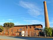
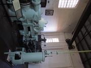
One of eight stations between Mundaring Weir and Coolgardie, basic operation of the scheme started in 1903. Associated with Engineer in Chief, C Y O'Connor. Important landmark of Cunderdin and emphasises the link with goldfields and with water supply. Has been restored for use as the historical museum of the district and will thus continue to ply its part in the community life.
large red brick building used to house steam pumps used in the Goldfields water scheme. Has a 100 ft brick chimney, made of curved bricks. Building now used as a museum. Situated on Great Eastern Highway in the Cunderdin town site.
Assessment 1974 Architect/builder unknown - Public Works Office Construction circa 1902
This information is provided voluntarily as a public service. The information provided is made available in good faith and is derived from sources believed to be reliable and accurate. However, the information is provided solely on the basis that readers will be responsible for making their own assessment of the matters discussed herein and are advised to verify all relevant representations, statements and information.
| Owner | Category |
|---|---|
| Vested in the Shire of Cunderdin | Local Gov't |
This information is provided voluntarily as a public service. The information provided is made available in good faith and is derived from sources believed to be reliable and accurate. However, the information is provided solely on the basis that readers will be responsible for making their own assessment of the matters discussed herein and are advised to verify all relevant representations, statements and information.
Lot 2 Forrest St Cunderdin
Near Museum ex 3 pumping station
Cunderdin
Wheatbelt
Constructed from 1906 to 1994
| Type | Status | Date | Documents |
|---|---|---|---|
| State Register | Registered | 28 Aug 2001 | HCWebsite.Listing+ListingDocument, HCWebsite.Listing+ListingDocument |
| Type | Status | Date | Documents |
|---|---|---|---|
| (no listings) |
| Type | Status | Date | Grading/Management | |
|---|---|---|---|---|
| Category | ||||
| Statewide Lge Timber Str Survey | Completed | 11 Dec 1998 | ||
| Classified by the National Trust | Classified | 05 Sep 1983 | ||
| Register of the National Estate | Permanent | 25 Mar 1986 | ||
| Municipal Inventory | Adopted | 31 Dec 1996 | 2 | |
16610 Goldfields Water Supply Scheme
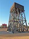
The stand for the square iron tank is of wood with its supporting members being round timber poles. It was erected in 1906, after the pipeline carrying water to Kalgoorlie was opened in 1903, and No 3 pumping station (now Cunderdin Historical Museum) is nearby. It is no longer in use but the main structure is sound. The tank holds approximatesly 59 kilolitres and the stand measures at base 8.6m x 8.4m (R Campbell).
| Name | Type | Year From | Year To |
|---|---|---|---|
| WA Government Railways | Architect | - | - |
Historic site
| Epoch | General | Specific |
|---|---|---|
| Original Use | Transport\Communications | Rail: Water Tower |
| Present Use | Transport\Communications | Rail: Water Tower |
| Type | General | Specific |
|---|---|---|
| Other | TIMBER | Other Timber |
| General | Specific |
|---|---|
| TRANSPORT & COMMUNICATIONS | Rail & light rail transport |
This information is provided voluntarily as a public service. The information provided is made available in good faith and is derived from sources believed to be reliable and accurate. However, the information is provided solely on the basis that readers will be responsible for making their own assessment of the matters discussed herein and are advised to verify all relevant representations, statements and information.
Historically important as part of the water supply for locomotives on the original railway line from Perth to Kalgoorlie and few if any others have survived. It is esteemed locally as a feature of the town
Assessment 1983 Construction circa 906 Timber tank stand supporting members being round wooden poles, square iron tank. Capacity approx 59 kilolitres, base of stand 8.6m x x8.4 m
This information is provided voluntarily as a public service. The information provided is made available in good faith and is derived from sources believed to be reliable and accurate. However, the information is provided solely on the basis that readers will be responsible for making their own assessment of the matters discussed herein and are advised to verify all relevant representations, statements and information.
| Owner | Category |
|---|---|
| Shire of Cunderdin | Local Gov't |
This information is provided voluntarily as a public service. The information provided is made available in good faith and is derived from sources believed to be reliable and accurate. However, the information is provided solely on the basis that readers will be responsible for making their own assessment of the matters discussed herein and are advised to verify all relevant representations, statements and information.

Main St Cunderdin
inc Cunderdin District Honour Roll
Cunderdin
Wheatbelt
Constructed from 1910 to 1956
| Type | Status | Date | Documents |
|---|---|---|---|
| State Register | Registered | 24 Nov 2000 | HCWebsite.Listing+ListingDocument, HCWebsite.Listing+ListingDocument |
| Type | Status | Date | Documents |
|---|---|---|---|
| (no listings) |
| Type | Status | Date | Grading/Management | |
|---|---|---|---|---|
| Category | ||||
| Municipal Inventory | Adopted | 31 Dec 1996 | 3 | |
| Classified by the National Trust | Classified | 11 Jun 2001 | ||
| Name | Type | Year From | Year To |
|---|---|---|---|
| H. Jefferis | Architect | - | - |
| Library Id | Title | Medium | Year Of Publication |
|---|---|---|---|
| 4011 | Conservation Plan for Cunderdin Hall | Heritage Study {Cons'n Plan} | 1999 |
Individual Building or Group
| Epoch | General | Specific |
|---|---|---|
| Present Use | EDUCATIONAL | Library |
| Present Use | GOVERNMENTAL | Town, Shire or District Hall |
| Original Use | GOVERNMENTAL | Town, Shire or District Hall |
| Present Use | SOCIAL\RECREATIONAL | Theatre or Cinema |
| Style |
|---|
| Inter-War Free Classical |
| Type | General | Specific |
|---|---|---|
| Wall | BRICK | Common Brick |
| Roof | METAL | Corrugated Iron |
| Other | TIMBER | Other Timber |
| Other | METAL | Other Metal |
| General | Specific |
|---|---|
| OCCUPATIONS | Hospitality industry & tourism |
| SOCIAL & CIVIC ACTIVITIES | Government & politics |
| SOCIAL & CIVIC ACTIVITIES | Community services & utilities |
This information is provided voluntarily as a public service. The information provided is made available in good faith and is derived from sources believed to be reliable and accurate. However, the information is provided solely on the basis that readers will be responsible for making their own assessment of the matters discussed herein and are advised to verify all relevant representations, statements and information.
Constructed from 1909, Constructed from 1926
Brick construction with cement facing 50ft x 35ft, walls 13ft and ceiling following principle up to collar tie- thence across, making top if ceiling 20ft high. The floor is jarrah 4" wide. The ceiling is asbestos. At the end of the main hall is an alcove to be used afterwards as a stage. Also there is a refreshment room 18ft x 14ft and a kitchen with fire place and copper, The contract price was 623 pounds. Architect - H Jeffreys". (ref: State Archives AN 7, Acc 689, File 586/23 p 52) The Eastern Recorder notes;"Hall is constructed of bricks and cement facing. Consists of a hall, supper room, scullery with stoe and copper. The plan of the hall will allow an extension when required of 24ft on the front. This makes room for public reading rooms and offices." (ref; Eastern Recorder 4-5-1910 p 3)
Reserve 10180, Lot 27 was the first location proposed for the hall (11-5-1906) this was amended to Lot 64 (24-12-1908). Lot 27 was considered to be too far from the railway station and the business area, so Lot 64 was sought. J Gallagher first requested a subsidy of 500 pounds 24-7-1908, for construction, the total estimated cost was 700 pounds. 17-10-1908 a letter to the Minister for Works from Maurice O'Connor says that there is a movement by some people to have the Hall built near the Hotel- the proprietor had offered a 1/2 acre block, but this was considered too small by some and the majority of residents opposed this proposal due to it's size. Most residents felt that there was plenty of Crown Land available to provide for this. As a result the residents decided to appoint a building committee which comprised; Fred Herman, T Hodgeson and P Donovan. Three trustees were also nominated; W Hastie, J Pascoe and G Jasper.In 1910, the committee also sought to have 3 ladies on the committee, which was approved. Tenders were called 25-6-1909. The Eastern Recorder notes 27-11-1909 that the erection of the hall seems delayed. It was completed 3-8-1910. The committee decided to allow skating, "..but if the floor starts to look damaged this may stop". It was considered to be a good source of revenue as there was still a good deal of money required to purchase a piano, seats and other furnishings. The first dance was held on Saturday 20th August 1910. The hall was opened officially in October 1910 by the Minister for Lands and was described as "It is substantially constructed of stone and brick and is large enough for all requirements and has a commodius and well arranged stage. Attached to the main hall are a supper room and pantry. This latter addition may well be commended to all committees about to nuild new hall. Not only does the oantry afford a convenient place to store crockery ets, but the built in copper, fireplace etc, will reduce to a minimum the labout attached to the paeparation of supper etc." (ref: Eastern Recorder 8-10-1910 p 5). Extensions were completed to the hall in 1926
| Ref ID No | Ref Name | Ref Source | Ref Date |
|---|---|---|---|
| DOLA file: 2616/06 | Government Gazette;"Lot 27 - Agricultural Hall". p 1402 | DOLA | 11-5-1906 |
| Ref Number | Description |
|---|---|
| Reserve 10180, Lot 27 and request for Lot 64 |
| Owner | Category |
|---|---|
| Shire of Cunderdin | Local Gov't |
This information is provided voluntarily as a public service. The information provided is made available in good faith and is derived from sources believed to be reliable and accurate. However, the information is provided solely on the basis that readers will be responsible for making their own assessment of the matters discussed herein and are advised to verify all relevant representations, statements and information.
Cunderdin Hall, a brick and iron structure built in at least three main stages between 1910 and 1956, has cultural heritage significance for the following reasons: • it has been continuously associated with the working, social and recreational life of the local community for almost a century; • its establishment represents the optimism and community spirit of the early twentieth century in the region, and its subsequent changes and enlargements indicate changing patterns of community life; and, • it has a well-designed classical facade which is an important part of the streetscape of Main Street, Cunderdin. Aesthetic Value Cunderdin Hall is a significant component of the streetscape of Main Street, Cunderdin. The facade of the Hall is a well-scaled late example of the dignified "free classical" architectural style often favoured for public buildings. The war memorial honour board is an impressive piece of wood carving and construction. Historic Value Cunderdin Hall is associated with the development of Cunderdin and the immediate area. The war memorial honour board is a tangible link with Australia's participation in World War I. Social Value Cunderdin Hall is and always has been a community work, meeting and recreat ional place; and the home of local organisations and services. Its growth and various uses over the years represent changes in patterns of work and leisure over almost a century. The war memorial board represents the community's desire to remember and honour those of its members who served and died in World War I, and indicates the impact of the war on the community. Raritv Cunderdin Hall is the only building of its architectural style and social function in the town of Cunderdin, and is thus unique in its local context. Condition The building is generally in good condition although the gutters in the main section of the hall need to be regularly cleared to prevent water seepage causing major problems in the future. Authenticity There have been three main phases of construction: the first in 1910, the second in 1922 and the third in 1956. The alterations have made it difficult to determine the extent of the 1910 building. The stage area, the floor and tie rods in the hall all date to 1910 and can be considered to be all that remains of the original core of the Cunderdin Hall. These areas have retained a good degree of authenticity. The 1922 front section is more easily defined and appears to be generally intact although new windows have been added to the east and west sides of this section. The Landcare office has retained its original 1922 layout, while the library's layout has been changed. The men 's toilet appears to date to this period, although the fixtures are more recent. The office area is therefore considered to have a high degree of authenticity. The sections added in 1956 have generally remained intact, with original fittings, although the kitchen and bio box have been either altered or removed. These areas also have a high degree of authenticity.
Cunderdin Hall is a brick and iron structure situated on the northern side of Main Street in Cunderdin's commercial precinct. On the western side of the hall is a craft shop (formerly a bakery and residence and Classified by the National Trust in ?). On the eastern side is the Post Office. There are no buildings on the southern side of Main Street which runs parallel with Great Eastern Highway. The building is divided into three distinct parts: the front section which accommodates two offices and public toilets, the middle section which is the hall and a rear section which contains the stage and kitchen facilities. The front facade is designed in the Federation Free Classical style, although this section of the hall was constructed in 1923. The facade is symmetrical and features a parapet with a central pedimental motif over the arched entry, inset with raised scroll-work. Other features include: a rendered plinth to sill height, a rendered band that runs across the building at window height, mouldings to the top of brick piers, areas of rough cast plaster and scroll work in a rendered band above the fanlights. At either end of the parapet and the central section, are decorative cement urns with animal faces. The walls are cavity brick (red) construction, while the hipped roof is clad with corrugated galvanised iron.. The whole facade has been painted in heritage colours of green, burgundy , white and sand. The front section contains two offices on either side of a central corridor. An ornate timber war memorial has been positioned on the western wall of the corridor. The memorial commemorates local servicemen who fell during World War I. The office on the eastern side of the corridor is used by Landcare while that on the western side houses a small library. Both rooms have pressed metal ceilings and were originally identical in size. The room which houses the library has been reduced in size to accommodate ate ladies toilets on the northern side. To the north of the Landcare office is the men 's toilet. The middle section of the building where the hall is located is cavity brick construction (cream) with a clerestory above. The gable roof is clad with corrugated galvanised iron. The hall features a timber floor, metal roof trusses and a large timber screen at the southern end of the hall. Ladies toilets (which are accessed from the exterior), are located on the south west side of the hall. At an earlier stage these toilets were accessed from the ladies cloakroom (now toilets). The rear section, which contains the stage, is double storey and was built in two phases. Stage l is cavity brick (red) construction and contains the stage with a storage area beneath. Exterior access to the area is via a set of double doors located in the north east corner. Sometime during the 1970s, a kitchen was added to the north of the stage area. The walls are constructed using cream bricks. The sliding windows are set into aluminium frames. The kitchen can be accessed from the stage area or from an exterior door which leads out onto a landing which also serves the double stage doors. The timber decking and stairs are supported on a metal frame.
Assessment 2001 Architect: H Jeppings Builder: J McKraken Construction 1910 Alterations/additions: 1923, 1956 The locality of modern day Cunderdin was first explored by Ensign Dale and J.S. Roe in the 1830s. However, its suitability as a prospective area to settle was not explored at this stage due to labour shortages and the distance from Perth. The district's appeal as an agricultural district had to wait until gold was discovered in the eastern districts in the 1880s. Gold brought not only wea lth to Western Australia, but the capability to provide an infrastructure which would render previously inaccessible agricultural land accessible. The Eastern Railway line was completed in 1894 and the Goldfields Water Supply in 1903. Cunderdin was chosen as the site for the No. 3 Pumping Station. The gazettal of the town in 1906 was accompanied by a building boom. By 1911, the town had a bakery ( 1908), goods shed ( 1909), a new hotel ( 1910), the school had been re-built (1910), post office ( 1911) and police station (1911) Cunderdin's first hall was constructed in 1904. However, it was a rather make-shift structure which did not adequately serve the growing community. A Cunderdin 1-Iall Committee was formed to oversee the construction of a new hall and in 1909 the Committee applied for a Grant from the state government. The committee also organised fund raising activities to raise the necessary money to build a new hall. Tenders were invited for an architect and builders. H. Jeppings was the architect and J . McCracken from Northam was the builder. The hall was completed by September 1910 and cost £696.15 .3. The government provided £250 and the building was officially opened by the Minister for Lands. The hall has undergone several alterations over the years. The first occurred in 1922 when new offices were built to accommodate the Meckering Road Board. Governor Newdegate opened the new offices. In I924 a library was opened in the building. In I956, Forbes and Fitzhardinge extended the sides of the hall and a new kitchen and bio-box were installed at the rear (northern end). Sometime during the 1970s the bio-box was removed, and the kitchen was re-modelled.
This information is provided voluntarily as a public service. The information provided is made available in good faith and is derived from sources believed to be reliable and accurate. However, the information is provided solely on the basis that readers will be responsible for making their own assessment of the matters discussed herein and are advised to verify all relevant representations, statements and information.
Mundaring
P25251 Goldfields Water Supply Scheme is part of this place and is on the National Heritage List. Starts in Mundaring, at Mundaring Weir and travels through the Shires of Mundaring, Northam, Cunderdin, Tammin, Kellerberrin, Merredin, Westonia, Yilgarn, Coolgardie and Kalgoorlie-Boulder.
Golden Pipeline
Mundaring
Metropolitan
Constructed from 1898
| Type | Status | Date | Documents |
|---|---|---|---|
| State Register | Registered | 08 Dec 2022 | HCWebsite.Listing+ListingDocument, HCWebsite.Listing+ListingDocument |
| Type | Status | Date | Documents |
|---|---|---|---|
| (no listings) |
| Type | Status | Date | Grading/Management | |
|---|---|---|---|---|
| Category | ||||
| (no listings) | ||||
25251 Goldfields Water Supply Scheme (NHL)
• The place is an excellent example of an initiative by the Western Australian Government to provide water to the Goldfields at the turn of the century.
• The place is rare as one of the largest pipelines in Western Australia, possibly the largest that supplies water.
• The place has aesthetic value as a landmark feature extending from Mundaring to Kalgoorlie.
• The place is rare and has scientific value as an innovative engineering design and construction method of a pipeline from the early 20th Century.
• The place is rare as a long-distance water pipeline in Australia built in the early 1900’s.
The Goldfields Water Supply Scheme, demonstrates exceptional technical achievement as one of the longest overland pipeline schemes attempted in the nineteenth century, both in Australia and the world, and was recognised as an outstanding engineering achievement; The has exceptional value in demonstrating the historical importance of the provision of water to settlements along the route from Mundaring to the Eastern Goldfields, The construction and operation of the Pipeline had considerable importance in contributing to the sense of place for the people of Western Australia, and visitors to the State, as a highly valued tourist destination, the educational, cultural and aesthetic aspects of which are appreciated by history and engineering enthusiasts and teachers to this day; Individual elements of the place, including the existing interpretation associated with the Golden Pipeline Heritage Trail, museums, archaeological sites and remaining buildings and infrastructure, collectively have exceptional potential to communicate the history of the Goldfields Water Supply Scheme and its importance to Western Australia; The place is associated with a number of notable figures in Western Australian history, including the Scheme's designer CY O'Connor, State and Federal politician Lord John Forrest, the Director of the Public Works Department HW Venn and former Superintendent of Public Works, architect George Temple Poole, who each contributed to the successful completion of the Goldfields Water Supply Scheme; and The place is an exceptional example of applied science, technical excellence and innovative design, reflecting the ongoing ingenuity and innovation demonstrated by the talented and committed engineers employed by the Goldfields Water Supply Branch, Public Works Department and other iterations of the Water Corporation in the provision of water in the State. The longevity of the scheme is associated with innovators Mephan Ferguson, James Couston, engineers Norman Fernie and Reg Keating, and James Mathers.
The Goldfields Water Supply Scheme extends in a discontiguous precinct across the 560km linear water pipeline, commencing at Mundaring Weir (1902, 1951) in the Helena Valley and terminating at Mount Charlotte Reservoir (1902) in Kalgoorlie-Boulder. Comprising six extant original Steam Pump Stations (1902) at Mundaring, Cunderdin, Merredin, Yerbillon, Ghooli and Dedari; the sites of two demolished Steam Pump Stations (1902) at O’Connor and Gilgai; Reservoirs and Tanks at O’Connor, Sawyers Valley, Bakers Hill, West Northam, Cunderdin, Merredin, Yerbillon, Ghooli, Bronti, Gilgai, Koorawawalyee, Dedari, Toorak, and Bullabulling; second generation Electric Pump Station at Merredin , and other community sites, ancillary structures; equipment and machinery, archaeological sites; and discontiguous portions of the main pipeline conduit associated with the construction and operation of the Scheme from 1902 to the present.
Phase I - Construction of the Goldfields Water Supply Scheme (1898 - 1903) Phase II – Problem Solving and Agricultural Expansion (1904 - 1940) Phase III – Comprehensive Water Supply Scheme, Upgrades & Refurbishments (1946 - 2013) Phase IV - Heritage Recognition and The Golden Pipeline (1992 - 2011)
High
Good
| Name | Type | Year From | Year To |
|---|---|---|---|
| Charles Yelverton O'Connor | Architect | 1898 | 1902 |
| Library Id | Title | Medium | Year Of Publication |
|---|---|---|---|
| 6452 | Mundaring Weir Precinct masterplan : final master plan report. | Heritage Study {Other} | 2002 |
| 7358 | Conservation plan for Goldfields Water Supply Scheme. Volume II, place M : No. 8 Pumping Station, Dedari. | Heritage Study {Cons'n Plan} | 1999 |
| 11426 | Goldfields Water Supply Volume III | Heritage Study {Cons'n Plan} | 1999 |
| 4897 | Conservation plan for Karalee Rock Water Catchment (Goldfields Water Supply Scheme - place J). | Heritage Study {Cons'n Plan} | 2000 |
| 7359 | Conservation plan for Goldfields Water Supply Scheme. Volume II, place N : Bullabulling reservoir. | Heritage Study {Cons'n Plan} | 1999 |
| 9248 | Constructing Australia: Triumphs and tragedies in building a nation. | C D Rom | 2007 |
| 6390 | Pipe-dream to pipeline : the eventful life of Nathaniel W. Harper. | Book | 2001 |
| 3680 | Conservation plan for No. 3 Pumping Station, Cunderdin. | Heritage Study {Cons'n Plan} | 1998 |
| 1774 | An exploratory bibliography of the Goldfields Water Supply of Western Australia (draft). | Report | 1982 |
| 4504 | Conservation plan for Mount Charlotte Reservoir (Goldfields water supply scheme - place O). | Heritage Study {Cons'n Plan} | 2000 |
| 11762 | Goldfields Water Supply Scheme, Main conduit, Western Australia | Heritage Study {Cons'n Plan} | 2016 |
| 6788 | Conservation plan for Koorarawalyee water catchment and railway station (Draft) (Goldfields Water Supply Scheme - place U). | Heritage Study {Cons'n Plan} | 2001 |
| 9806 | Mundaring Weir water Supply interpretation precinct design. | Book | 2010 |
| 7350 | Conservation plan for West Northam regulating tanks : (Goldfields Water Supply Scheme - place T) (draft). | Heritage Study {Cons'n Plan} | 2001 |
| 7356 | Conservation plan for Goldfields Water Supply Scheme. Volume II, place I : No. 6 Pumping Station, Ghooli. | Heritage Study {Cons'n Plan} | 1999 |
| 7547 | Celebrating 100 years of the Goldfields Water Supply Scheme. | Brochure | 2003 |
| 7354 | Conservation plan for Goldfields Water Supply Scheme. Volume II, place G : No. 4 Pumping Station, Merredin. | Heritage Study {Cons'n Plan} | 1999 |
| 7351 | Conservation plan for Toorak Hill reservoir : (Goldfields Water Supply Scheme - place V) (draft). | Heritage Study {Cons'n Plan} | 2001 |
| 7352 | Conservation plan for Goldfields Water Supply Scheme. Volume II, place A : No. 1 Pumping Station Mundaring. | Heritage Study {Cons'n Plan} | 1999 |
| 7348 | Conservation plan for Sawyers Valley summit tanks : (Goldfields Water Supply Scheme - place R) (draft). | Heritage Study {Cons'n Plan} | 2001 |
| 6675 | Mundaring Weir : conservation plan (draft). | Heritage Study {Cons'n Plan} | 2000 |
| 1608 | Conservation and interpretation plan for No.1 Pumping Station Mundaring. | Heritage Study {Cons'n Plan} | 1996 |
| 5988 | Centenary of the Goldfields Water Supply Scheme 1903-2003. | Brochure | 2003 |
| 7444 | The agricultural areas, Great Southern towns and Goldfields Water Supply Scheme : souvenir to commemorate the completion of the project. | Book | 1961 |
| 10170 | The origins of the Eastern Goldfields water scheme in Western Australia: an exercise in the interpretation of historical evidence. | Book | 1954 |
| 4644 | Conservation plan for Goldfields Water Supply Scheme : volume 1. | Heritage Study {Cons'n Plan} | 1999 |
| 7357 | Conservation plan for Goldfields Water Supply Scheme. Volume II, place K : No. 7 Pumping Station, Gilgai. | Heritage Study {Cons'n Plan} | 1999 |
| 8902 | River of steel. A history of the Western Australian Goldfields and Agricultural Water Supply 1903 - 2003. | Book | 2007 |
| 7355 | Conservation plan for Goldfields Water Supply Scheme. Volume II, place H : No. 5 Pumping Station, Yerbillon. | Heritage Study {Cons'n Plan} | 1999 |
| 7353 | Conservation plan for Goldfields Water Supply Scheme. Volume II, place B : No. 2 Pumping Station, O'Connor. | Heritage Study {Cons'n Plan} | 1999 |
| 7349 | Conservation plan for Bakers Hill regulating tank : (Goldfields Water Supply Scheme - place S) (draft). | Heritage Study {Cons'n Plan} | 2001 |
| 6794 | Conservation plan for Bullabulling township and railway catchment. (draft) : a supplement to the Bullabulling Reservoir conservation plan (Goldfields Water Supply Scheme - place N). | Heritage Study {Cons'n Plan} | 2001 |
| 9899 | Mundaring Weir water supply improvement project: heritage management strategy. | Heritage Study {Other} | 2011 |
| 6326 | The golden pipeline heritage trail guide : a time capsule of water, gold and Western Australia. | Book | 2002 |
| 4693 | Goldfields Water Supply heritage project. | Book | 1999 |
| 5544 | Golden Pipeline interpretation plan. | Heritage Study {Other} | 2001 |
Other Built Type
| Epoch | General | Specific |
|---|---|---|
| Original Use | GOVERNMENTAL | Power Station |
| Present Use | GOVERNMENTAL | Pumping Station |
| Present Use | EDUCATIONAL | Museum |
| Style |
|---|
| Vernacular |
| Type | General | Specific |
|---|---|---|
| Wall | BRICK | Common Brick |
| Wall | METAL | Steel |
| Roof | METAL | Corrugated Iron |
| General | Specific |
|---|---|
| SOCIAL & CIVIC ACTIVITIES | Community services & utilities |
| DEMOGRAPHIC SETTLEMENT & MOBILITY | Technology & technological change |
| DEMOGRAPHIC SETTLEMENT & MOBILITY | Resource exploitation & depletion |
| DEMOGRAPHIC SETTLEMENT & MOBILITY | Exploration & surveying |
This information is provided voluntarily as a public service. The information provided is made available in good faith and is derived from sources believed to be reliable and accurate. However, the information is provided solely on the basis that readers will be responsible for making their own assessment of the matters discussed herein and are advised to verify all relevant representations, statements and information.