Local Government
Donnybrook-Balingup
Region
South West
113 Airstrip Rd Balingup
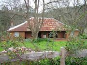
Brooklands Homestead
Padbury's Brook
Donnybrook-Balingup
South West
Constructed from 1904
| Type | Status | Date | Documents |
|---|---|---|---|
| State Register | Registered | 02 Sep 1997 | HCWebsite.Listing+ListingDocument, HCWebsite.Listing+ListingDocument |
| Type | Status | Date | Documents |
|---|---|---|---|
| (no listings) |
| Type | Status | Date | Grading/Management | |
|---|---|---|---|---|
| Category | ||||
| Municipal Inventory | Adopted | 27 Nov 2013 | Category 1 | |
| Register of the National Estate | Permanent | 28 Sep 1982 | ||
| Classified by the National Trust | Classified {HBS} | 05 Nov 1979 | ||
Individual Building or Group
| Epoch | General | Specific |
|---|---|---|
| Present Use | RESIDENTIAL | Single storey residence |
| Other Use | COMMERCIAL | Office or Administration Bldg |
| Original Use | FARMING\PASTORAL | Homestead |
| Style |
|---|
| Victorian Regency |
| Type | General | Specific |
|---|---|---|
| Roof | METAL | Corrugated Iron |
| Wall | BRICK | Common Brick |
| General | Specific |
|---|---|
| SOCIAL & CIVIC ACTIVITIES | Religion |
| DEMOGRAPHIC SETTLEMENT & MOBILITY | Exploration & surveying |
| PEOPLE | Early settlers |
| OCCUPATIONS | Grazing, pastoralism & dairying |
| DEMOGRAPHIC SETTLEMENT & MOBILITY | Settlements |
This information is provided voluntarily as a public service. The information provided is made available in good faith and is derived from sources believed to be reliable and accurate. However, the information is provided solely on the basis that readers will be responsible for making their own assessment of the matters discussed herein and are advised to verify all relevant representations, statements and information.
Brooklands is a good and substantial example of a Victorian Regency homestead house with spacious wrap around verandahs and turned verandah posts. Historically, it is one of the first properties taken up in the district and illustrates the operation and extent of the early pastoral leases in the area. It is also important for its association with the first owner of the land, Walter Padbury and his brother, Edwin, who first developed the property, and subsequent owners William Spencer and Charles Brockman, for whom the house was constructed.
Brooklands is a substantial single-storey, brick and corrugated iron farmhouse in the Victorian Regency style (although constructed in the Federation period). It is set on sloping land in the Blackwood Valley with cleared land in front and forest behind. The front facade is symmetrical with a central timber front door with side lights and highlights and two pairs of French doors on either side. The roof is a moderately pitched hip and a deep verandah surrounds the house.
In the early 1860s, Walter Padbury purchased some freehold land and leased a larger area for pastoral purposes in the Balingup district. His brother, Edwin (b. 1811) undertook the initial development of the property known at this period as Padbury’s Brook, including erection of a six room homestead and a workers’ house (both brick construction), a barn, stables and stockyards etc.. In January 1876, Edwin died. In April, William Spencer (b. 1825) purchased the property for £4,000, took up residence, and named it ‘Brooklands’. In late 1881 - early 1882, it was offered for sale or lease, and George Dowden purchased it. In 1886, ‘Brooklands Estate’, which comprised 1961 acres freehold and 18,280 acres leasehold land at this date, was sold to well known pastoralist Charles Samuel Brockman (b. Guildford, 1845, d. 1923), who married Dowden’s eldest daughter, Jane, in that year. Fred Lukis came to manage the pastoral property for Brockman. In 1898, the townsite of Balingup was taken out of the ‘Brooklands Estate’. In c. 1901, the Brockman family moved to ‘Brooklands’ and took up residence in the house there. In 1904, a fine new homestead, constructed of bricks baked on the property, was built by a man named O’Brien for an agreed sum of £800 ($1,600), with a bonus of £100 ($200) to be paid if completed by Christmas, which he achieved. The house comprised five bedrooms, a large lounge, large dining room, hallway, kitchen, pantry, laundry, bathroom, workroom etc., with wide verandahs on all sides. The Brockmans took up residence in the new house, and his employees, the Delaportes, moved into the original homestead (fate unknown). Brockman had three workman's cottages built near the road for his employees. In 1911, Brockman retired to ‘Sandridge’ (near Bunbury) and sold ‘Brooklands’ to Wedge and Lowe, who later sold it to Lee Allnutt. Post-World War I, the Government acquired Brooklands Estate for soldier settlement and sub-divided it into blocks about 130 acres (54 h.a.) in area, which proved too small to be viable. V. P. Widdup, purchased the homestead block, and took up residence in the homestead. Later he increased his holding to 317 acres (132 h.a.), which was leased to Dick Cause for a period before Widdup sold ‘Brooklands’ to the Universal Brotherhood in 1975. The Universal Brotherhood established their commune on the property, using the homestead as the administration block, and erected some other buildings at the place.
High
Good
| Ref ID No | Ref Name | Ref Source | Ref Date |
|---|---|---|---|
| West Australian 27 Dec. 1881, 10 Jan. 1882, 5 Nov. 1885 Frost, A. C. Baylya-Balinga: A History of Balingu | |||
| Western Australian Times 18 April 1876 | |||
| Harris & Besley; "Western Australia; The Garden of the Colony, Bunbury, Busselton, Bridgetown" | 1895 | ||
| Article by Gloria Widdup | |||
| Inquirer 1, 8, 15 & 22 March 1876 | |||
| Battye, J. S. Cyclopedia of Western Australia Cyclopedia Company, Perth, 1912-13, Facsimile Edition Hesperian Press, Victoria Park, Western Australia, 1985, Vol.2, pp. 216-217. | 1985 | ||
| A.C. Frost; " Bayla Balinga" . | 1979 |
| Ref Number | Description |
|---|---|
| 19 | Municipal Inventory |
| Reserve | Lot/Location | Plan/Diagram | Vol/Folio |
|---|---|---|---|
| Nelson 8134 | 1293/671 |
| Owner | Category |
|---|---|
| Brooklands Community Incorporated | Other Private |
This information is provided voluntarily as a public service. The information provided is made available in good faith and is derived from sources believed to be reliable and accurate. However, the information is provided solely on the basis that readers will be responsible for making their own assessment of the matters discussed herein and are advised to verify all relevant representations, statements and information.
A large house and a good example of a gentleman’s residence of the period with spacious verandahs and turned verandah posts. It has been altered little. Historically, it is one of the first properties taken up in the district and was one of the first substantial homes built in the district.
It is a traditional single storey Colonial homestead built of bricks and CGI roof. It consists of five bedrooms, a lounge, dining room, hallway, kitchen, pantry, workroom and with wide verandahs on all sides, It is still in good condition and used as a central meeting place
Assessment 1979 Construction 1904 Built for Charles Brockman who acquired the property when he left the Gascoyne district in 1886.
This information is provided voluntarily as a public service. The information provided is made available in good faith and is derived from sources believed to be reliable and accurate. However, the information is provided solely on the basis that readers will be responsible for making their own assessment of the matters discussed herein and are advised to verify all relevant representations, statements and information.
Old Padbury Rd Balingup
Nelson Location 165. Lot 11.
Donnybrook-Balingup
South West
Constructed from 1880 to 1904
| Type | Status | Date | Documents |
|---|---|---|---|
| State Register | Registered | 14 Dec 2001 | HCWebsite.Listing+ListingDocument, HCWebsite.Listing+ListingDocument |
| Type | Status | Date | Documents |
|---|---|---|---|
| (no listings) |
| Type | Status | Date | Grading/Management | |
|---|---|---|---|---|
| Category | ||||
| Classified by the National Trust | Classified | 03 Dec 1979 | ||
| Register of the National Estate | Permanent | 22 Jun 1993 | ||
| Municipal Inventory | Adopted | 27 Nov 2013 | Category 1 | |
| Library Id | Title | Medium | Year Of Publication |
|---|---|---|---|
| 11991 | Golden Valley Tree Park : Homestead | Heritage Study {Cons'n Plan} | 2023 |
| 2137 | The Blackwood : a valley in transition. | Book | 1981 |
| 11989 | Worker’s Accommodation, Golden Valley Tree Park, | Heritage Study {Other} | 2023 |
| 11990 | Golden Valley Tree Park : Workers accommodation | Heritage Study {Cons'n Plan} | 2022 |
Individual Building or Group
| Epoch | General | Specific |
|---|---|---|
| Original Use | FARMING\PASTORAL | Cottage |
| Present Use | VACANT\UNUSED | Vacant\Unused |
| Original Use | FARMING\PASTORAL | Homestead |
| Original Use | RESIDENTIAL | Single storey residence |
| Style |
|---|
| Victorian Georgian |
| Type | General | Specific |
|---|---|---|
| Wall | RENDER | Cement Dressed |
| Wall | EARTH | Adobe {Mud Brick} |
| Wall | RENDER | Other Render |
| Roof | METAL | Corrugated Iron |
| General | Specific |
|---|---|
| DEMOGRAPHIC SETTLEMENT & MOBILITY | Workers {incl. Aboriginal, convict} |
| OCCUPATIONS | Timber industry |
| PEOPLE | Early settlers |
This information is provided voluntarily as a public service. The information provided is made available in good faith and is derived from sources believed to be reliable and accurate. However, the information is provided solely on the basis that readers will be responsible for making their own assessment of the matters discussed herein and are advised to verify all relevant representations, statements and information.
This home with its typical simple design and fine lacework on the verandahs has considerable architectural merit and charm. The assessment includes the garden with its oak trees, two palm trees, wisteria and large cypress hedge but does not include the organ room which has been altered unsympathetically. Golden valley also has association with the prominent families F.C. Roberts (who first took up the property and was an early settler), Moutray Bunbury (pioneer Bunbury family) and later the Craig family.
A simple style homestead with verandahs front and back, and the distinction of a large room at one end added later to accommodate a pipe organ, which has been removed and now resides in the North Perth Congregational Church. (since the formation of the Uniting Church, its whereabouts is not certain). It was built of brick with a corrugated iron roof in the 1880s. Parts of the organ room which were in a dangerous state have been removed and replaced in an unsympathetic manner. The verandahs are still intact and have some splendid iron lacework of a very distinctive style. The mature gardens also add to the character of Golden Valley.
Assessment 1979 Construction 1895
This information is provided voluntarily as a public service. The information provided is made available in good faith and is derived from sources believed to be reliable and accurate. However, the information is provided solely on the basis that readers will be responsible for making their own assessment of the matters discussed herein and are advised to verify all relevant representations, statements and information.
Constructed from 1880, Constructed from 1904
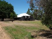
Golden Valley is a good example of a Victorian Georgian homestead house which is sited in a picturesque location and is a landmark on the Old Padbury Road. The place is associated with Charles Fox Roberts and his son William and illustrates early building techniques in the colony, as well as the lifestyle of the early European settlers. It illustrates the development of the Balingup area and is associated with a number of prominent locals.
Located on Old Padbury Road, 2km south of Balingup townsite, Golden Valley comprises a homestead (c. 1880s) and workers' accommodation (1880s). The homestead house is a single storey rendered mud brick house with a moderately pitched gabled corrugated iron roof in the Victorian Georgian style. There is a verandah at the front and rear. The front facade is symmetrical with two doors and two pairs of Georgian windows. A large organ room was added to the north side in the early 1900s with a similar roof pitch but in 1991 there was a reconstruction of the roof and the pitch was substantially lowered, although the tall red brick corbelled chimney remains. Internal accommodation consists of four bedrooms, living room, kitchen, dining room and organ room, outside toilet, bathroom and laundry. Most of the joinery is jarrah. The central core of the building was pit sawn, butt joined boards. The workers' accommodation is a two roomed dwelling which is timber-framed with exterior walls of corrugated iron, and interior walls of pressed metal and lathe and plaster, with a corrugated iron roof. It is set in former farmland and an arboretum. The front hedge has been removed and a new hedge planted with seeds taken from original hedge.
In 1885, Charles Fox Roberts (b. 1844) obtained Nelson Location 165. National Trust of Australia (W.A.) assessment notes a two room corrugated iron building (extant, 2012) was believed to have been the first house on the property, worked by his son, William Charles Fox Roberts (b. 1865), who married Mary L. Longbottom (b. 1864) in 1895. The present homestead, in the Victorian Georgian style, constructed of soft burnt bricks in mud mortar, with mostly jarrah joinery, and a corrugated iron roof, was built as their family home. The central core of the building was pit sawn jarrah, with butt jointed boards. There were verandahs at the front and rear. In the early 1900s, at the north-west side a large room was added with one end built up to accommodate a pipe organ, and the room became known as the organ room. It has not been ascertained if it was added under Roberts’ ownership or after the place was sold to Mountray Frederick Richardson in 1904, or Francis Craig, who owned it from 1906. (During World War I, his son, Colin, married the daughter of General Birdwood, Commander-in-Chief of the Australian Imperial Forces, and after the war they returned to Golden Valley. When General Birdwood visited he agreed to plant the first tree and open the Memorial Park hence known as Birdwood Park.) In 1920, Edmund Peter Blakeney purchased Golden Valley, which he owned, occupied and worked until 1945, when he sold it to David Bruce Goyder, who resided there with his family. In 1946, it was transferred to Jean Barbara Goyder and David John Barr Goyder, who continued living there. In 1963, John Tomlinson purchased Golden Valley. In 1977, the Forests Department (now Department of Environment and Conservation) acquired it for its pine planting program. In 1981, some conservation work was done on the homestead. A committee was formed under Balingup Progress Association to raise money for the work, manage the project, and to develop an arboretum as a joint project with CALM on an area of 60 h.a. to be set aside for the Golden Valley Tree Park that would comprise two sections at the west and east sides of Padbury Rd. In 1984, new Certificates of Title issued for Lots 10 and 11 replaced those for Nelson Locations 102 and 165, with the homestead at Lot 11 (9.9128 h.a.). In 1991, conservation and other works were implemented, directed by architect John Pidgeon, with input from the National Trust, which later recorded removal and unsympathetic replacement of the organ room. For most of the subsequent period the homestead has been occupied for residential purposes.
Mostly high although the modification to the roof of the organ room in 1991 is an intrusive element.
Good
| Ref ID No | Ref Name | Ref Source | Ref Date |
|---|---|---|---|
| Frost, A. C. Baylya-Balinga A History of Balingup, W. A. Donnybrook-Balingup Shire Council | 1979 | ||
| Assessment Document RHP | 2001 | ||
| National Trust of Australia (W. A.) Assessment | 1979 |
| Ref Number | Description |
|---|---|
| 34 | Municipal Inventory |
| Reserve | Lot/Location | Plan/Diagram | Vol/Folio |
|---|---|---|---|
| Lot 11 | |||
| Nelson Location 165 |
| Owner | Category |
|---|---|
| Dept Conservation & Environment | State Gov't |
This information is provided voluntarily as a public service. The information provided is made available in good faith and is derived from sources believed to be reliable and accurate. However, the information is provided solely on the basis that readers will be responsible for making their own assessment of the matters discussed herein and are advised to verify all relevant representations, statements and information.
Southampton Rd Balingup
Lot 82
Donnybrook-Balingup
South West
Constructed from 1862
| Type | Status | Date | Documents |
|---|---|---|---|
| Heritage Agreement | YES | 22 Feb 1999 | HCWebsite.Listing+ListingDocument |
| State Register | Registered | 29 Jun 1999 | HCWebsite.Listing+ListingDocument, HCWebsite.Listing+ListingDocument |
| Type | Status | Date | Documents |
|---|---|---|---|
| (no listings) |
| Type | Status | Date | Grading/Management | |
|---|---|---|---|---|
| Category | ||||
| Classified by the National Trust | Classified | 03 Sep 1973 | ||
| Municipal Inventory | Adopted | 27 Nov 2013 | Category 1 | |
| Library Id | Title | Medium | Year Of Publication |
|---|---|---|---|
| 5187 | Southampton Homestead, Balingup : conservation works : final report / prepared by Lynn Nunn. | Heritage Study {Other} | 2001 |
| 4057 | Southampton Southampton Road Balingup Conservation Plan | Heritage Study {Cons'n Plan} | 1998 |
Individual Building or Group
| Epoch | General | Specific |
|---|---|---|
| Original Use | RESIDENTIAL | Single storey residence |
| Present Use | FARMING\PASTORAL | Homestead |
| Original Use | FARMING\PASTORAL | Kitchen |
| Original Use | FARMING\PASTORAL | Homestead |
| Style |
|---|
| Victorian Georgian |
| Type | General | Specific |
|---|---|---|
| Wall | EARTH | Adobe {Mud Brick} |
| Wall | BRICK | Common Brick |
| Roof | METAL | Corrugated Iron |
| General | Specific |
|---|---|
| DEMOGRAPHIC SETTLEMENT & MOBILITY | Government policy |
| OCCUPATIONS | Grazing, pastoralism & dairying |
| PEOPLE | Early settlers |
| DEMOGRAPHIC SETTLEMENT & MOBILITY | Land allocation & subdivision |
This information is provided voluntarily as a public service. The information provided is made available in good faith and is derived from sources believed to be reliable and accurate. However, the information is provided solely on the basis that readers will be responsible for making their own assessment of the matters discussed herein and are advised to verify all relevant representations, statements and information.
The property along with Ferndale and Brooklands is the oldest in the district.
9 rooms with cellar plus outbuildings (one wattle and daub(. No evidence of mill erected in 1862 (referred to in correspondence). Originally roofed with jarrah shingles, now covered with CGI. A verandah runs the length of the main building and overlooks the Blackwood River.
Assessment 1973 Construction: 1862 - 1882
This information is provided voluntarily as a public service. The information provided is made available in good faith and is derived from sources believed to be reliable and accurate. However, the information is provided solely on the basis that readers will be responsible for making their own assessment of the matters discussed herein and are advised to verify all relevant representations, statements and information.
Constructed from 1862
Southampton Homestead was one of the first homesteads in the Balingup district and was constructed by settler Richard Thomas Jones for his extended family. The simple Victorian Georgian homestead and its adjacent kitchen/bakery constructed of hand made bricks with mortar of local clay are located in a picturesque setting on the banks of the Blackwood River. Mature oak trees dating from the early twentieth century contribute to the setting. The place demonstrates the lives and farming practices of the early settlers in the district and Jones had a water mill nearby on the banks of the Blackwood River.
Southampton Homestead comprises a single-storey mud brick and corrugated iron homestead and a related brick and corrugated iron kitchen/bakery, both constructed in the Victorian Georgian style. The homestead house has a moderate to steeply pitched roof with a symmetrical front facade. The central front door is flanked by vertically proportioned casement windows and a verandah runs along the front of the house, flanked by brick enclosures at each end. Internally there are nine rooms with cellar, plus outbuildings (one wattle and daub). Located approximately 100 metres from Southampton House is a wooden grave, sometimes called the Afghan's Grave. The inscription on the tombstone reads, 'Sacred to the memory of John Allum who departed this life May 15 1868, aged 83 years'.
Southampton, named by its first owner, Richard Thomas Jones (arr. 1829, d. 1876), who was granted Nelson Location 4 in 1860, is one of the three oldest homesteads in the Balingup district. He and his sons, Richard Thomas and William James, initially built a wattle and daub house on the river flats. After floods swept through the house in 1862, they selected a site on higher ground where they built a nine room house of mud bricks, made on site, and timber, with a jarrah timber shingle roof, outbuildings including a kitchen/bake-house and scullery adjacent to the house, a workers’ cottage (known as Hampshire Cottage) set apart from the house, and a brick barn. The Jones family took up additional leasehold land, mostly using the property for mixed farming and cattle grazing, and oak trees and fruit trees were planted. In 1868, John Allum, believed to have been the family’s elderly Indian/Afghan/Cinghalese servant/cook, died and was buried about 100 metres from the house (at the side of Southampton Road). In 1882, Southampton was advertised for sale but it did not sell and the brothers continued to live and work there. An 1895 sketch showed the house, outbuildings and plantings. After Richard died in 1903, Southampton was sold to Eliza Annie Gull, of Guildford, in 1905. In 1910, she sold it to William Nicholas, who with his wife and family moved to reside at Southampton. After he and his wife died their daughters, Zoe and Shirley, lived reclusively. By the mid-1940s, the farm was un-worked and the outbuildings in poor condition. From c. 1950, it was left vacant and in 1952, when Eric Frank Aurisch and his wife, Dorothy May, Aurisch purchased Southampton, the house was dilapidated. They made it habitable and re-built the rear verandah. In 1956, Southampton was sold to dairyman Edwin ‘Jack’ Miles, who established his herd on the property, where he lived with his family. By 1966, when the Forests Department acquired Southampton for pine planting, some outbuildings were no longer extant. In the late 1960s, the house and remaining outbuildings fell into disrepair. In 1972, the so-called ‘Old Miles Farmhouse’ was leased for 20 years to architect Beresford Collins and his wife, who were required to restore the house, which they used as a weekender. The work was not completed, so the lease was not renewed. From 1996, Jack Miles’ son, Dennis, leased the house and used it intermittently. From the late 1990s, CALM undertook a rationalization program in the Blackwood Valley, and Southampton homestead and the surrounding unplanted area was sold to private owners, who have done some restoration, and also located sites of some outbuildings. In 2013 the place was badly damaged by fire.
High
The place was badly damaged by fire which destroyed all but the walls of both the main house and the kitchen.
| Ref ID No | Ref Name | Ref Source | Ref Date |
|---|---|---|---|
| Frost, A. C. Bayla-Balinga A History of Balingup Donnybrook-Balingup Shire | 1979 | ||
| Erickson, Rica (ed.) Bicentennial Dictionary of Western Australians pre-1829-1888 University of Western Australia Press, Nedlands | 1988 | ||
| Western Australia: The garden of the colony. Bunbury, Busselton, Bridgetown & c. Harris & Besly, Perth | 1895 | ||
| Considine and Griffiths Architects Pty Ltd, with Robin Chinnery, Historian ‘Southampton Conservation Plan | 1998 |
| Ref Number | Description |
|---|---|
| 56 | Municipal Inventory |
| Reserve | Lot/Location | Plan/Diagram | Vol/Folio |
|---|---|---|---|
| Lot 82 |
| Owner | Category |
|---|---|
| J Pow | State Gov't |
This information is provided voluntarily as a public service. The information provided is made available in good faith and is derived from sources believed to be reliable and accurate. However, the information is provided solely on the basis that readers will be responsible for making their own assessment of the matters discussed herein and are advised to verify all relevant representations, statements and information.
460 Brookhampton Rd Brookhampton
Lot 399, Reserve 7736 & 8563
Donnybrook-Balingup
South West
Constructed from 1922, Constructed from 1899
| Type | Status | Date | Documents |
|---|---|---|---|
| State Register | Registered | 20 Sep 2002 | HCWebsite.Listing+ListingDocument, HCWebsite.Listing+ListingDocument |
| Type | Status | Date | Documents |
|---|---|---|---|
| (no listings) |
| Type | Status | Date | Grading/Management | |
|---|---|---|---|---|
| Category | ||||
| Municipal Inventory | Adopted | 27 Nov 2013 | Category 1 | |
| Register of the National Estate | Indicative Place | |||
| Classified by the National Trust | Classified | 04 Feb 1980 | ||
| Aboriginal Heritage Sites Register | Interim | |||
Individual Building or Group
| Epoch | General | Specific |
|---|---|---|
| Original Use | SOCIAL\RECREATIONAL | Other Community Hall\Centre |
| Present Use | SOCIAL\RECREATIONAL | Other Community Hall\Centre |
| Other Use | EDUCATIONAL | Primary School |
| Style |
|---|
| Federation Bungalow |
| Type | General | Specific |
|---|---|---|
| Other | STONE | Granite |
| Wall | TIMBER | Weatherboard |
| Roof | METAL | Zincalume |
| General | Specific |
|---|---|
| SOCIAL & CIVIC ACTIVITIES | Cultural activities |
| OUTSIDE INFLUENCES | World Wars & other wars |
| DEMOGRAPHIC SETTLEMENT & MOBILITY | Immigration, emigration & refugees |
| SOCIAL & CIVIC ACTIVITIES | Education & science |
This information is provided voluntarily as a public service. The information provided is made available in good faith and is derived from sources believed to be reliable and accurate. However, the information is provided solely on the basis that readers will be responsible for making their own assessment of the matters discussed herein and are advised to verify all relevant representations, statements and information.
An old community hall which is a fine example of a typical timber construction. It is a timber building in a district proud of their timber, and it is enhanced by its setting; the fairground, the brook, the memorial to those that died in the war and the oak trees.
The weatherboard and corrugated iron hall with a verandah on the north side facing the oval and picnic ground over the road. At the back are some asbestos additions. Apparently the hall was the centre of the social life in past days and the oval was used for sport, cricket and football as well as local fairs. It was built at the turn of the century.
Assessment 1980 Construction 1900, alterations 1904, 1922
This information is provided voluntarily as a public service. The information provided is made available in good faith and is derived from sources believed to be reliable and accurate. However, the information is provided solely on the basis that readers will be responsible for making their own assessment of the matters discussed herein and are advised to verify all relevant representations, statements and information.
Constructed from 1922, Constructed from 1899
Brookhampton Hall is a picturesque timber weatherboard hall set in a group which includes the war memorial and oak tree. It is an important facility that has served the area for over a hundred years. It has been the venue for many social and sporting activities for the district, and also served as a church and school. Several generations of almost all the local families have used or attended functions in the hall since its construction. It is also significant as the home of the Brookhampton Bell Ringers since their formation in 1904.
Brookhampton Hall is an oiled weatherboard hall with a moderately pitched hipped corrugated iron roof and deep front verandah. A gabled addition has been abutted on the east side. There are three double hung timber sash windows on the verandah and an entrance door at each end of the verandah. There are two hooded double hung windows on the west side facade. An enclosed skillion section at the rear is also constructed of oiled weatherboards and contains the toilets. Two very large English oak trees stood in front, of which only one remains. The War Memorial is also located in front of the Hall.
Pioneer settler Henry Cain donated part of Wellington Location 582, for a hall site at Brookhampton in 1898. He served on the building committee with Frank Miller, John Thomson, Charlie Fowler, and Thomas (Tom) Miller, who was Chairman for 21 years. In 1899, on this triangular piece of land, Tom Miller, assisted by Frank Miller, an able ‘bush carpenter’, who had taken up land at Thomson Brook, built the timber construction Brookhampton Hall. On 6 December, with an enrollment of 18 children, a so-called provisional school opened at the Hall, where it operated until 1903. In this period the Hall was used also for Methodist Church services, dances and social gatherings. The hall was surrounded by a traditional picket fence which is no longer extant. Early plantings at the Hall included at least two oak trees, of which one large specimen survives in 2012. A sports ground was established on level ground in proximity. The Hall was the focal point of social life in the district, and as such the logical site for erection of a War Memorial post-World War I. In 1922, Brookhampton Hall was altered to incorporate a stage and dressing rooms, and an enclosed verandah was erected along the western side to serve as a supper room, in which a chimney and fireplace were built in 1923. In 1924, H. E. Lloyd extended the Hall by 16 ft. and replaced the original floor that had been ruined by roller-skating. In 1994-5 conservation works included removing asbestos at the rear and replacing it with timber weatherboards, refurbishing washroom facilities, and repairs to the verandah, walls and roof. In 1999, the centenary of Brookhampton Hall was celebrated, and the place continues in use in the early 2000s. Since the early 1900s, the Brookhampton Bell Ringers have been associated with the Hall. In 1903, when Frank Young came to live at Brookhampton with his family, he brought the bells from the disbanded St Andrew’s Bell Ringers, of Coolgardie, and taught some members of the Thomson’s Brook Musical Club to play in 1904. Soon the Brookhampton Bell Ringers were entertaining in the district and beyond, gaining wide recognition. They practised at Brookhampton Hall, where the bells were kept until the 1970s. Descendants of many of the original bell ringers learnt their skills and the Brookhampton Bell Ringers have continued to entertain communities in the South-West, where they are unique.
High
Good
| Ref ID No | Ref Name | Ref Source | Ref Date |
|---|---|---|---|
| National Trust of Australia (W.A.) Assessment | 1980 | ||
| RHP 00713 | Heritage Council of Western Australia, Assessment Documentation | 2002 | |
| Scott, June (ed.) The Brookhampton Hall 1899-1999 Brookhampton Progress Association | 1999 |
| Ref Number | Description |
|---|---|
| 17 | Municipal Inventory |
| Reserve | Lot/Location | Plan/Diagram | Vol/Folio |
|---|---|---|---|
| 7736 & 8563 | Lot 399 |
| Owner | Category |
|---|---|
| Shire of Donnybrook - Balingup | Local Gov't |
This information is provided voluntarily as a public service. The information provided is made available in good faith and is derived from sources believed to be reliable and accurate. However, the information is provided solely on the basis that readers will be responsible for making their own assessment of the matters discussed herein and are advised to verify all relevant representations, statements and information.
460 Brookhampton Rd Brookhampton
Lot 399
Donnybrook-Balingup
South West
| Type | Status | Date | Documents |
|---|---|---|---|
| (no listings) |
| Type | Status | Date | Documents |
|---|---|---|---|
| (no listings) |
| Type | Status | Date | Grading/Management | |
|---|---|---|---|---|
| Category | ||||
| Statewide War Memorial Survey | Completed | 01 May 1996 | ||
| Municipal Inventory | Adopted | 27 Nov 2013 | Category 1 | |
00713 Brookhampton Hall
Historic site
| Epoch | General | Specific |
|---|---|---|
| Original Use | MONUMENT\CEMETERY | Monument |
| Present Use | MONUMENT\CEMETERY | Monument |
| Type | General | Specific |
|---|---|---|
| Other | STONE | Granite |
| General | Specific |
|---|---|
| OUTSIDE INFLUENCES | World Wars & other wars |
This information is provided voluntarily as a public service. The information provided is made available in good faith and is derived from sources believed to be reliable and accurate. However, the information is provided solely on the basis that readers will be responsible for making their own assessment of the matters discussed herein and are advised to verify all relevant representations, statements and information.
Constructed from 1919
Brookhampton War Memorial has social significance in honouring those residents of the Brookhampton area who gave their lives in the two World Wars of 1914-18 and 1939-45. Located in a prominent position adjacent to Brookhampton Hall, the memorial and its enclosing fence adds to the aesthetic value of the complex. It illustrates the enormous human sacrifice made by the small regional communities and commemorates the renowned fighting spirit of the Anzacs.
Brookhampton War Memorial is a grey granite obelisk mounted on a Donnybrook sandstone plinth and surrounded by a low fence of horizontal metal pipe between painted granite and concrete pylons. Brookhampton War Memorial was constructed as a tribute to the soldiers from the district who were killed in WWI and WWII.
In 1919, Brookhampton War Memorial was erected in the grounds of Brookhampton Hall to commemorate the men from the Thomson’s Brook district who had served in World War I (1914-18). Local residents voluntarily raised the funds for the memorial, which was made by Peter and Gillies, of Subiaco. The grey granite obelisk, ‘enclosed with a double iron railing, supported by four corner pillars of grey granite’, had the 33 names of those who enlisted, including nine who were killed, cut and gilded on one side of the obelisk (Bunbury Herald 20 Dec. 1919). On 17 December, W. G. Pickering, M.L.A., unveiled the so-called Soldiers’ Memorial, and after expressing his sympathy to those present who had been bereaved, he ‘congratulated the people of the district on erecting such a lasting tribute to their men’ (ibid). In 1920, local residents subscribed for a new fence around the Soldiers’ Memorial. In June 1921, a working bee was held to clear and plough up the ground around the Memorial in readiness for planting trees, shrubs and roses. On 6 August, Messrs. Gibbons and Sharp laid out the ground and small garden beds, young men dug over the ploughed ground, plantings were made, and the young ladies planted the surrounds of each bed with violets. The schoolmaster, Mr. Sharp, undertook to keep the ground in order, and local residents anticipated that ‘in time this little plot should prove to be one of our beauty spots’ (Bunbury Herald 16 August 1921). Following World War II, a stone was added to the plinth to record the names of those who served in that war. The local community highly values the Memorial and has well maintained it through into the early 2000s.
High
Good
| Ref ID No | Ref Name | Ref Source | Ref Date |
|---|---|---|---|
| RHP 00713 | Heritage Council of Western Australia, Assessment Documentation RHP 00713 | ||
| Bunbury Herald 20 Dec. 1919, 25 June & 24 Sept. 1920, 1 July & 16 August 1921 |
| Ref Number | Description |
|---|---|
| 18 | Municipal Inventory |
| Reserve | Lot/Location | Plan/Diagram | Vol/Folio |
|---|---|---|---|
| Lot 399 |
| Owner | Category |
|---|---|
| Shire of Donnybrook - Balingup | Local Gov't |
This information is provided voluntarily as a public service. The information provided is made available in good faith and is derived from sources believed to be reliable and accurate. However, the information is provided solely on the basis that readers will be responsible for making their own assessment of the matters discussed herein and are advised to verify all relevant representations, statements and information.
Lot 3124 Grist Rd Donnybrook
Donnybrook Sandstone Quarry No.3
No.3 Quarry
Donnybrook-Balingup
South West
Constructed from 1904
| Type | Status | Date | Documents |
|---|---|---|---|
| State Register | Registered | 27 Feb 2015 | HCWebsite.Listing+ListingDocument, HCWebsite.Listing+ListingDocument |
| Type | Status | Date | Documents |
|---|---|---|---|
| (no listings) |
| Type | Status | Date | Grading/Management | |
|---|---|---|---|---|
| Category | ||||
| (no listings) | ||||
Good
Historic site
| Epoch | General | Specific |
|---|---|---|
| Present Use | VACANT\UNUSED | Vacant\Unused |
| Original Use | MINING | Other |
| Type | General | Specific |
|---|---|---|
| Other | STONE | Donnybrook Sandstone |
| General | Specific |
|---|---|
| DEMOGRAPHIC SETTLEMENT & MOBILITY | Settlements |
| DEMOGRAPHIC SETTLEMENT & MOBILITY | Immigration, emigration & refugees |
| DEMOGRAPHIC SETTLEMENT & MOBILITY | Resource exploitation & depletion |
| OCCUPATIONS | Mining {incl. mineral processing} |
This information is provided voluntarily as a public service. The information provided is made available in good faith and is derived from sources believed to be reliable and accurate. However, the information is provided solely on the basis that readers will be responsible for making their own assessment of the matters discussed herein and are advised to verify all relevant representations, statements and information.
South Western Hwy Donnybrook
Includes: Station building & platform; goods shed; Station Master's House; Stevenson screen; crane; oak tree & Apple Lights. Lot 598.
Donnybrook Railway Precinct
Donnybrook-Balingup
South West
Constructed from 1893
| Type | Status | Date | Documents |
|---|---|---|---|
| State Register | Registered | 18 Mar 2005 | HCWebsite.Listing+ListingDocument, HCWebsite.Listing+ListingDocument |
| Type | Status | Date | Documents |
|---|---|---|---|
| (no listings) |
| Type | Status | Date | Grading/Management | |
|---|---|---|---|---|
| Category | ||||
| Municipal Inventory | Adopted | 27 Nov 2013 | Category 1 | |
| Aboriginal Heritage Sites Register | Interim | |||
| Classified by the National Trust | Classified {Trees} | |||
| Classified by the National Trust | Classified | 14 Jun 1999 | ||
| Statewide Railway Heritage Surve | Completed | 01 Aug 1994 | ||
Good condition with various modifications
| Library Id | Title | Medium | Year Of Publication |
|---|---|---|---|
| 9500 | Archival report for packing shed and 5-ton crane, Donnybrook/Balingup Shire. | Archival Record | 2010 |
| 4065 | Donnybrook Railway Precinct Conservation Plan | Heritage Study {Cons'n Plan} | 1999 |
Precinct or Streetscape
| Epoch | General | Specific |
|---|---|---|
| Original Use | Transport\Communications | Rail: Railway Station |
| Original Use | Transport\Communications | Rail: Housing or Quarters |
| Original Use | RESIDENTIAL | Single storey residence |
| Original Use | Transport\Communications | Rail: Office or Administration Bldg |
| Present Use | Transport\Communications | Rail: Other |
| Present Use | GOVERNMENTAL | Other |
| Style |
|---|
| Vernacular |
| Type | General | Specific |
|---|---|---|
| Wall | TIMBER | Weatherboard |
| Roof | TILE | Terracotta Tile |
| Roof | METAL | Corrugated Iron |
| General | Specific |
|---|---|
| DEMOGRAPHIC SETTLEMENT & MOBILITY | Settlements |
| TRANSPORT & COMMUNICATIONS | Rail & light rail transport |
| SOCIAL & CIVIC ACTIVITIES | Education & science |
| OUTSIDE INFLUENCES | Tourism |
This information is provided voluntarily as a public service. The information provided is made available in good faith and is derived from sources believed to be reliable and accurate. However, the information is provided solely on the basis that readers will be responsible for making their own assessment of the matters discussed herein and are advised to verify all relevant representations, statements and information.
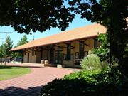
The Donnybrook Railway Precinct, comprising the former Station building. the former Stationmaster's House, the Oak Tree, the Stevenson Screen. the Crane and the former Goods Shed are or heritage significance for the following reason: AESTHETIC VALUE The Donnybrook Railway Station, the Stationmaster's House and Goods Shed are important contributors to the corpus of intact heritage fabric within the townscape fabric of Donnybrook thereby providing aesthetic charae1erislics valued by the local community. The main structures in the Precinct form an integral part of the streetscape In providing a significant portion of the western boundary of the linear pattern of development of the town over the last century. HISTORIC VALUE The complex is a particularly good example and a marker or the part played by the railway and the railway personnel in the development of the township and of the evolution of local industry, agriculture and services handled through the railway facilities, industries which have made a significant contribution to the wealth and culture of the State. The survival in close proximity in an established precinct of the Station masters House, the Goods Shed and the Station itself is unusual, and provides an example of the responsibilities or the Stationmaster in the hierarchy of the community, and in his associated responsibilities such as collecting the weather data, directing rail traffic and managing stall. SOCIAL VALUE The Donnybrook Station Precinct. particularly the Station and the Stationmaster's Residence are significant as major parts of the Donnybrook town centre and contribute to the sense of place of the community. The Oak tree, the Crane and the Stevenson screen are important contextual contributors lo the fabric of the former working Precinct Other mature free specimens 6.9 enunciated, along the western perimeter of the Precinct similarly contribute to the heritage ambience and sense ol place. RARITY The survival in close proximity in an established precinct of the Stationmasters House, the Goods Shed and the Station itself is unusual. REPRESENTATIVENESS The Donnybrook Railway Station Precinct is significant in having a recognisable corpus of extant railway structures which demonstrate the characteristics of a working railway precinct. CONDITION, INTEGRITY and AUTHENTICITY The Donnybrook Railway Precinct is in good condition with a good level of integrity and authenticity.
THE SETTING In an area running parallel to the South Western Highway in the Donnybrook townsite between the railway line and the road is a flat expanse of ground that contains the Station, a paved slip road, lawns, a bituminised parking area to the south and the Stationmaster's house and yard to the north. The car park is flanked on the east by a brick Toilet Block with a screen of mixed shrubs. Several large specimens of Kurrajong and Oak line the western edge of the South Western Highway at this point in the Township. Along the west, the screen is a mixture o! native shrubs on a raised bund. This screen is intermittent in nature. but still permits glimpses of the packing sheds and Crane along the western edge of the site. Situated to the east of the sta1ion is a mixture o! evergreen trees comprising Box trees, Pines and Kurrajongs. To the north of the Station stands a fine example of an English Oak (Quercus robur). Around the curtilage of the Stationmaster 's House are the remnants of earlier plantings including a Cotoneaster, Palms, Bottlebrushes and Hibiscus. The fruit trees are still productive,but are showing signs of decline through age. THE OAK TREE This large specimen of English Oak, (Quercus robur)I is is located to the north of the Station near the Stationmaster's House. It is a single trunk specimen showing the characteristic growth of a mature oak with a large rounded crown. The lowest branches curve downwards to create a shady canopy and the uppermost branches extend upwards. Characteristic of this group of trees is the wider spread of the lower canopy compared to the upper. THE STATION FORECOURT LAWN Contained within a circular bitumen drive and lying to the east of the Railway Station is a large flat green expanse o1 grass. Planted within this area js a mixture of deciduous and evergreen trees specifically liquidambars, ashes and a magnolia. Also contained in this section is playground equipment, park benches, picnic tables, a drinking fountain. light pole standards, flower beds, model apples on metal stands and several examples of Donnybrook stone. OTHER TREES Kurrajong Brachychiton populneus. a semi-deciduous tree found in Victoria, New South Wales, Queensland and the Northern Territory It is an upright growing tree that develops a single trunk and grows to a height of between 12m and 1Sm. It was considered to be easy to grow, drought tolerant, easily grown from seed. In times of drought the foliage was considered to have a supplementary fodder value The tree characteristically displays a profusion of bell shaped sponed flowers. [Lord. E.L., Shrubs and Trees for Australian Gardens. The Griffin Press, Adelaide 1974.J Japanese Loquat :Eriobotrya jasponica found on the main islands of Japan and in eastern and central China. II is a small evergreen tree to 6 -7m tall and as wide, with a short trunk and with the outer branches often sweeping the ground. (Rowell, R. J., Ornamental flowering trees in Australia, University Of New South Wales Press., N.S.W. 1991.] Plum ;Prunus domestics, probably brought originally from western Asia and now commonly round in Europe. It is a deciduous tree and grows to a height of 1O m. {Johnson, H.. The International Book of Trees, Mitchell Beazley Publishers, London 1980.] It was introduced to the Colony in the Nineteenth Century. THE BUILDINGS & THE STATION Station Exterior: Building Foundation: The Station Building is set about 55 metres to the west and parallel to !he South Westem Highway which runs generally due north and south through this section of the Donnybrook township. The Station building Comprises two buildings separated by three open bays, both buildings being linked by a tiled gambrel roof The roof cantilevers over the platform to the west and equally to the east The buildings have been constructed against a retained, raised section [generally running north-south) which forms the platform. A short section of raised ground has been returned into the open bays. The soil under the station buildings generally remains at ground level, the main flooring of the buildings being of standard timber construction, at former platform level. Building Structure : The main dressed timber structure comprises a grid of paired, dressed. square section, stop chamfered timber posts set on fully strutted bases, each pair of posts supporting a timber principal rafter at mid point, tied at ceiling height. each, in turn support by struts sprung from the same height. The end bays are each supported on timber beams spanning the posts beyond the building. The roof form is gambrel type with timber louvre ventilator panels at each end. The wall panel infilling in the bays between posts are set on a standard timber frame with horizontal, painted rusticated jarrah weatherboard cladding with scolia profile recess. The openings are all set in the infilling bays. The eaves at the gambrels are battened and the spandrels are infilled with painted timber lattice on the diagonal. The underfloor areas are enclosed by painted spaced battens. A further substructure of pur1ins attached through timber gussets spans between the post bays with an additional layer of rafters all surmounted by tile battens. Soma subsidence and lean is evident in the paired posts comprising the southern bay of the southern building. Measurements suggest that the western post of the pair has sunk and the pair together have a lean of at least 30mm from vertical in an east-west plane resulting in the eaves gutter in the same plane being some 300mm llower at its western extremity compared to its eastern extremity. Possible causes including deterioration of the substance of the post and or strutting below ground, changes in the foundations resulting flrom plumbing excavations in the vicinity , the llong term loading effect on timber [cantilevered) and damage from defects in the rainwater goods and all should be investigated. All of the dressed timberwork comprising the structure of the stationi is painted. The paintwork is in good condition, although it appears to be very thick in places. The roof is clad with Marseilles pattern terra-cotta roof tiles. No special ti es or accessories were presently evident at the gable ends of the ridges, or indeed, on the ridge itself . Some of the roof tiles had broken. Some deteriora1ion in the roof battens over the enclosed section of the ceiling void over the main office was evident in 1996, apparently from termite infestation. The first building recently housed the Tourist Office, the other, to the south, houses a Store Room and toilets. A red brick chimney of plain design extends above the roof line at the northern end of the northern building. The original joinery is painted timber conforming to standard profiles for the period. The original windows throughout are clear glazed double hung sashes, the top sashes being divided with sash bars into nine lights. The joinery is In good condition. Interim changes to former ticket windows and other special openings are evident. Some doors are timber paneled type and others are or ledged and braced construction. Their condition varies. Some remnant door and window furniture remains, but most of the door furniture is no longer in operating condition, having been replaced. A ramp structure with tubular steel handrailing bearing a sign "Tourist information Centre" and timber decking prov ding access to the south eastern corner of the northern building was noted to be of more recent origins. It has an offset section to provide access from the ramp to the platform level. Access to the building has been provided by the installation of a timber framed door suite with clear glazing installed to replace timber panels. A timber retaining wall with a waling piece set back from the east face of the building, has been installed to make up the level differences between the platform and approach levels of the Station in the three open bays between the former Tourist Office and the southern building. In addition, a short length of Staging has been erected outside the Store Room in the east wall of the southern building. No sign of the original picket fencing at Platform level remains. A slatted, painted timber sea1on welded steel supports has been set against the northern building along the east side at ground level. It is consistent with the seat design shown on the original drawing Located on the platform between the posts of the open bays. Itis in good condition. Rainwater goods: ·The building has bracketed eaves gutters of iron construction with iron down pipes along the long sides of the building. The gutter faces are set well back from the face of the platform kerbing. The downpipes lead directly into the platform without break. The rainwater elements are all painted, but are in poor condition and in many cases blocked up, rotten, or leak at the joints. Some lengths have separated all with either consequent or future potential damage 10 the foundation of the adjoining post structure of the building. The extant downpipes are of a diameter considerably in excess of the size shown on the contract drawing; it is therefore unlikely the stormwater pipes under the platform were not also increased in si e at the same time from the size shown on the drawings. The Platform: The platform is bitumen paving over a compacted base laid between timber retaining formers with a solid timber platform kerb. It is evident that the asphalting has been recoated as the present level finishes above the floor level of the station rooms at the doorways. The topping coat is showing signs of deterioration where washed by stormwater. Beyond the station, the ground on the east side of the platform has been pitched back to ground level and the pitching is presently grassed. Some tubular steer handrails on tubular Steel standards have been installed along the interface between the bitumen paving and the grass at both ends of the Station. The handrail is painted, but in fair condition only. The dressed, open picket fences shown on the contract drawings between the buildings and extending north between the Stationmaster's Office and the post in the north eastern comer of the building, are no longer evident. No indication of the type of platform adopted for the original station at Donnybrook has been located or could be detected from the photos of the earlier building. Physical inspection of the site provided no additional information in this regard. It is likely that the original platform was a compacted earth filled retained type. Telephone Cabinets A pair of recently installed metal and plastic telephone cabinets set on granolithic topped concrete bases are positioned under the roof at the south and of !he building on the east side at ground level. Drainage A concrete lidded tank and riser is evident along the southern side of the south end of the Station Building. It probably dates from the sewerage installation and/or amendments to the toilet facilities in the building. No records could be located. Station Interior The former Ticket Office Wing. {the northern wing) This part of the building is presently divided into three rooms each lined and ceiled with battened, painted sheeting and with painted jarrah dados. Most of the timber joinery is intact under the heavy coats of paint. Some of the door and window furniture has been replaced, or later furniture supplements the original fabric. The Timber floors have been exposed and re-surfaced in the main space and have been covered in others. The electrical services still run in surface mounted conduit, to original fixtures, although some have been replaced. The former Stationmaster's Office has a door in the south west comer leading out onto the platform. At the northern end. on the subdividing wall, is a face brick fireplace with unpainted, nosed, red brick chimney breas1s and a painted timber over-mantle. The interior of the firebox has been painted. The fireplace is not deep and is most likely a type intended for coal fuel. The hearth could not be inspected due to the floor covering. Timber shelving has been fitted to the side of the fireplace. Some components of the door furniture were missing. The Instrument Room now serves as a kitchenette although the base panel for the instruments and switchgear remains on the south wall. Changes to the wall linings and dado are a consequence of the plumbi119 installation. The partition forming the Guard's Room at the south end of the Traffic Office has been removed together with all of the former counter and ticket desk leaving an open room. Joinery in the external walls is generally intact with the exception of the relatively recent installation of timber framed glazed doors in the south western comer of the room providing access to the ramp. The interior including the timber dados and the battened asbestos fibre reinforced cement sheet linings over.remain generally in good order and intact. Some of the joinery and joinery furniture no longer functions due to inappropriate or inadequate surface preparation during successive painting operations . The Rest Rooms [the southern wing] This section of the building is divided into three main spaces each lined and ceiled with battened, painted sheeting and with now painted jarrah dados. Most of the timber joinery is intact. again, under the heavy coats of paint. Some of the door and window furniture has been replaced, or later furniture supplements the original fabric. Changes to the buildings to incorporate the Men's Toilet facilities into the volume of the wing included the installation of concrete backed stainless steel urinal S1alts and partitioned water closets within the former Waiting Room. The installation is relatively crude and unsightly in a timber framed structure of this nature. The changes included the relocation of the main partition wall and the removal of the original wan seating together with the addition of the toilet partitioning. Some or the original fabric remains. The present cisterns include stainless steel push button units. The condition of the facilities is described as serviceable. There is a Store: room beyond the Men's Toilet occupying part of the former Ladies Waiting Room. Beyond there is an Annexe to the Ladies Toilet with an intact seC1ion of timber seating, now enamel painted. The Anne)(e leads into the Ladies Toilet at the end ol the wing. Some of the fittings and fixtures, eg the pedestal and basin, are consistent with items contemporary with the original structure. THE STATIONMASTER'S RESIDENCE. [lnspected and measured 27 August 1997J The Stationmaster's Residence is located to the north of The Railway Station between the South Western Highway and the railway line. The house faces south towards the Station approach road and is a timber framed structure with full length verandahs, partly enclosed, extending along the north and south elevations. The building is clad with dressed jarrah weatherboard in a rusticated profile. The roof is clad with galvanised corrugated iron and gabl6d with a steep pitch. breaking to a lesser pitch over the rear, southern, verandah and a separately pitched lean-to front, northern, verandah. The southern verandah has an enclosed section at the eastern side, the northern verandah has been fully enclosed. All of the timber and lined surfaces have been painted cream. In its original form, the building comprised four main rooms and central passage [subdivided probably as noted in 1905 6}, under the main roof. There are two brick fireplaces with timber mantelpieces in the two eastern rooms, the northernmost of which was originally the kitchen . A newer kitchen has been provided under the lean-to roof at the rear with a stove set in a brick lined recess with a sheet steel flue above the brickwork. The original kitchen has been converted into a living room. The four rooms are arranged each side of a central corridor which is about 8' [2 400mJ wide divided to form an entrance hall accessed from the front door and leading to a vestibule beyond. The timber floors are 150mrn wide [Jarrah boards running parallel with the axis of the passage through the house. Some internal doors are four panel timber type, consistent with the 1890s provenance of the building, several have been removed and others since replaced with flush panel door of post war origins. Similarly the windows throughout the house were all of a different style and type, some dating from the original cons1ruc1ion with double hung and louvre substitutions of various dates. It is as if a lot of left over G1ock had to be used up on this building. The internal walls are lined with fibre-reinforced [probably asbestos] cement sheeting battened out in timber and painted. It is possible this material is a substitution from the original lining material. The par1ition dividing the central passage from the vestibule is Clad with horizontal jarrah boarding with a V· jointed tongue and groove [f&G] profile. The ceiling heights vary considerably throughout the structure. The original ceilings in all probability have been substituted for the current painted, battened fibre-reinforced cement sheeting. The ceiling in two of the rooms has a section ceiled 'on the rake,' an unusual occurrence in the main rooms of a house The ceiling heigh1 in these rooms is 3 900, while the flat ceilings in the other rooms on the opposite side of the passage area 3 500 high, and 3 100 in the entrance hall; the much lower kitchen ceiling has sweep comer vents executed in fibrous plaster, more likely substituted in the 1950s. other alterations evident from the 1950s include the installation of louvre windows, a partition along the railway side of the front verandah, the substitution of the central posts of the front verandah with galvanised tubular steel and the enclosure under the lean-to roof or a sec1ion of the front verandah eX1ending from the front door to the east side of the residenC9. The eX1emal cladding is in weatherboard profile matching the ear1ier section, but with a face of 3.75"l95mmJinstead or the original 4.75" [120mm] face. The original timber verandah floor has been replaced with granolithic topped concrete. The materials utilised in the enclosure of the eastern section of the north verandah to form the newer kitchen including a stainless steel sink and white console type stove is consistent with 1950s fabric. The other side of the north verandah has been enclosed to form a bathroom with internal toilet on the railway (west} side, at the same time. The bathroom is fitted with a vanity toilet pan, bath and riser and shower recess of recent origins. Outbuildings A corrugated iron clad timber framed washhouse is extant at the north west side of the house. It has a lean-to galvanised painted corrugated iron roof and contains a water heater and a pair o1 cement troughs set against the south wall. The copper and plinth has been removed. To the north and west of the washhouse is a timber framed, painted jarrah weatherboard lilined water closet with porcelain pan, and with a low level cistern or more recent origins. The holes for the bracket fixings for the earl er cement cistern are still evident The roof of the WC is two pitched galvanised corrugated iron. A further shed with a gabled corrugated iron roof and vertically fixed corrugated iron cladding, horizontally fixed weatherboards and sheet wall cladding exists some metres to the north of the main house. Its lining fabric has been replaced 1rom another location evidenced by the pattern of painting on the internal surfaces. An 1800 high corrugated fibre cement fence divides the Sta1ionmaster's House from the railway lines. THE STEVENSON SCREEN [Inspected 27 August 1997) The site of 1he screen is located a short distance to the west of the Station building, but over the main railway track. The screen comprised a white painted timber framed box with the remnants of bottom hinged louvre paneled doors on both sides and similar. but fixed panels at the sides. The lid of the box is marine bonded plywood painted white. The framing is Oregon pine or a similar softwood and the cabinet appears to have been supported on four timber legs as the comers of the box structure were once carried down to the ground. At some stage, the legs have been cut off and two galvanised tubular steel standards sat in a base in the ground have been bolted to the main box struc1ure as an alternative support. The box contains internal racks profiled presumably to support the weather gauging instruments. The box is in poor condition, and the door frames and most of the louvres have been smashed. The remnants were retrieved following the inspection from the general area of the cabinet, for storage at the museum. The rocks, however appear intact. The paintwork is in need of rectification. THE CRANE [Inspected 27 August 1997) The 5 ton Crane is noted as having been in the Station Yard by 1912. It is located on the west side of the railway line and well to the south of the other extant heritage fabric. The crane is mounted on a concrete block orientated north-south; its lifting tackle has been removed although all of the mechanism remains. The crane has a swivelling base, cast cogs and the steel superstructure is painted with a dark grey metallic based paint, only in fair condition. The steel and iron comprising the s1Ncture is in need of protection from rust, particularly the meeting surfaces, now that it is no longer in use. The base block is in good condition. GOODS SHED c1893 The Goods Shed is located in line with the Station, straddling a loop line with extant lines running through the building. The building is timber framed and clad with unpainted galvanised corrugated iron roof and walls. The former openings for railway trucks have been sheeted over partially with corrugated iron and with translucent sheeting of a matching profile at the head of the opening, a feature which helps to accent the former use of the opening. The formation and tracks remain in situ. The structure has jarrah posts with heavy timber roof trusses with steel ties at the king posts. The internal floor is a raised stage and is accessible from ramps around the perimeter of the struc1ure. No evidence of probable former timber staging was found as it appears that the staging has been replaced with a concrete structure evident at ground level beneath the iron wall dadding. The staging extends outside the building to the north. The openings are generally intact. The wall Structure is of timber studwork. At the top of the studwork are steel brackets suppor1ing corbels, in tum supporting the trusses with the addition of timberwork above the stud walling to increase its height. A lean-to roof on the north side has Davis trusses as pur1ins and appears to have been a later addition. The Goods Shed has more recently been used as retail premises and is intact and in fair to good condition. FORMER LOCO YARDS This area previously contained Coal stage, Water Tank [with extant riser], coal breaker, Loco Shed, sand box and Tumtable. None of these elements remain except the riser base which e>Cists at ground level only. This comprises a circular, steel stanchion base located some distance to the south of the platform roughly in line with the crane. It appears to be part of the water service from the river to the former Water Tank. It has a perforated black rubber gasket with a number of bolt holes was still evident. Some steel light or power poles with cross trees remain to the north and south of the Station. No evidence of other former railway assets such as the turntable, line forming, water tower, coal stage, coal breaker, loco shed. 'out-of' store, signaling gear etc remain. Other cottages and barracks, the tricycle stores and so on, have all been removed. Only the main through line, which is raised above the level of the other extant lines throLJ9h the goods yard, is presen1ly in general use, the other lines being of lighter section. Most of the points remain. The main points leading to the shunting yard were removed in 1997 but have since been replaced at the south end of the shunting yards. The lines formerly crossing Regent Street to business premises to the west were removed some years ago with most of the signaling gear. The former Loco Yards now contain raised earth garden beds, a brick toilet block and a bituminized parking area to the south of the Station extending to corrugated iron warehousing now used as a fruit mart.
Assessment 1999 A private railway, built in 1687 by the contractor G J Hastie between Sunbury and Boyanup, had to be partly rebuilt due to construction difficulties when it was taken over by the State Government and opened in March 1891.Hastie had operated the line following its completion. and had paid rent for it to the Government. Three isolated lines including this one were concatenated with the 1893 opening of the South West main line from East Perth to Picton Junction. Tenders were called for the line from Boyanup to Minninup [Donnybrook), a distance of 11 miles. (17.6 km] in 1892. Six tenders were received, Byfield and Risety's quote of £12,470 was accepted. Work commenced in January T 893 with the erection of a sawmill at Boyanup. In February, a subcontractor, Mr Pulley commenced work on the bridge over the Preston River. Due to the alignment selected for the railway, 3 miles {5k) of the Boyanup to Donnybrook road had to be re-aligned and built by the contractors. Additional bridges at Gavin's Gully and one closer to Minninup [Donnybrook] had to be constructed. ['the Westland Austin J.J The Engineer-in-Chief, C Y O'Connor, did a final inspection ol the line on the day of the opening, 16111/1893. Donnybrook became a junction as the lines to Northcliffe and Katanning branched from there. The 42 mile 26 chains long Donnybrook to Bridgetown extension was opened in 1098 [Westem Australian Railways, Annual Report to 1898-99), and further extended to Pemberton in 1926 and Nor1hdiffein 1933. The Donnybrook to Katanning branch was extended to Noggerup in 1908, Noggarup to Boyup Brook in 1909 and Boyup Brook to Kojonup end Katanning in T 912. The completion of the first Donnybrook Railway Station coincided with the opening of the extended railway line to the township in 1893. The station was first called Minninup and was located 131 miles 66 chains south of Perth. It is likely that the Goods Shed, the 5O' diameter turntable, the Locomotive Shed, the Coal Stage and the Water Tank were built at the same time. These elements were certainly evident by 1898. English Oak or Common Oak, Quercus robur. to the east of the station and south of the Stationmasters House was planted c1B90 by the early settlers according to the plaque erected under the tree in 1991 by the Country Women's Association. On 2nd February 1894, tenders for the Stationmaster's House were called and accepted on 5th April 1694 by which time the station had been renamed Donnybrook . The successful tender of £437i9tt) to construct the building, was submitted by A Donald & Co. [GG 13/4/1894 p.355.) The first stationmaster was James Waaver. The loop was extended and the dead end provided with water column, horse trough etc, in February 1904. Additions to the Stationmaster's House were commenced in 1905 and completed in February 1905. A 20 ton Weighbridge was completed on 24 April 1921 and a new fruit Shed was built in December 1922 In August 1928, following a great deal of agitation from the local community. work commenced on the new Station Building. The original station building was demolished. and a new bridge was proposed to be erected for completion in May 1929. The single-storey Station shown on the contract drawing was to comprise of two main buildings 14'6" wide internally with three bays of a covered way between the elements. The roof is shown as a cantilever projecting equally over the platform on the west and 10 the east [presumably for the future railway line on the ea.st side). The northern building was proposed to contain the public entrance to the Station Platform and ticket window through open picket gates along the north side. The other accommodation was to include the Stationmaster's Office with fireplace (1 x 13' bay], the Instrument Room (1 x 10' bay], the Traffic Office (2 x 12' bays], and the Guards Room (1 >e 10' bay]. The other building was intended 10 contain a Waiting Room [1 x 14' bay]. the Ladies Waiting Room {1 x 13' bay] leading into a Lavatory [1 x 4' bay].(The Contract Drawing 1928] By 1936. the Goods Shed is depicted as a square building as before and the adjoining weighbridge and galvanised iron cabin was shown on documentation as Poo/ey·s Weighbridge. On the eastern side of the line, the Railway Trolley Shed complex has been extended with two Ways and Works Sheds, a Tool Cabin, a shod marked Gang Motor, two Electrical Sheds and a Motor Store. Several fences in the complex are depicted as constructed from old sleepers. The turntable and spur connection has been removed from the drawing although its outline is evident on the document suggesting that the Turntable would have existed in 1938. In addition, extensive garden beds are shown along the Bladcwood Road frontage at the southern end of the Precinct. and a grove of ornamental trees is shown planted two rows deep along the front of the Station tenninating at the north endin another garden flanking 1he Station approach whichis shown as gravelled. Hoardings are indicated between the grove and the approach garden. The Stationmaster's Housein 1938is shown with enclosed comers on each side of the bacl<; verandah and a Washhouse directly to the north of the house. The perimeter of the Station building proper has not altered although the allocation of internal spaces has.The 1920 plan notes alterations from August 1938 are in File 16080138, Folio 4. From the northern end. the ramp, gates and the Stationmaster's Office remain, the Instrument Room has become the Staff Room. the Traffic Office and ticket counter remain, the Guards Roomis marked 'R'. The facilities in the southern end of the building appear unchanged except that a small tank has been installed under the verandah roof. Southwards along the platform there are hoardings shown along the edge separating in tum, a Levers Enclosure. a small shed, the Out of Store and a Cream Shed ormsny the Fruit ShedJ, in order. The Latrine, previously shown to the north of the Stationis no longer evident on the 1938 drawings although two trees [or shrubs] appear to have replaced the structure. The drawing has a circular inset with detail of the connections to the overhead tank. Stormwater and water service lines are shown on the drawing as well as fencing and paving finishes. [Surveyed, plotted and traced by S A Loftus. 11111/1938, Field Book 4104, LB 4833.) The Stevenson Screen Weather records have been held for Donnybrook (Donnybrook Post Office) at the Bureau of Meteorology and dare from 1902. The site was opened in 1900 and was designated no.009534 at Lat.33"34' 2S"S Long.115'49'27"E. at an elevation of 63 metres. There are only intermittent records between March 1968 and January 1988 after the Station became 'unattended'. Stevenson screen is described as 'A standard housing for meteorological thermometers. Itis similar to the 'large thermometer screen' but is smaller. The screen was designed by Thomas Stevenson a civil engineer and father of Robert Louis Stevenson, the well known Scottish author. The purpose of the screen is to afford internationally standardised, well ventilated protection against direct solar radiation. [Reed's Nautical Almanac] The Crane No records relating specifically to the date of Installation or the Crane have been found. The alignment of its current mounting suggests it has been remounted from its original situation parallel and adjacent To the loop line. The Crane was last used by Glenn Mitchell for loading Donnybrook Slone onto Railway Trucks. Recent Development Documentation suggests the hoarding alongside the Station Approach was still in place in front of the Station and marking the Station Approach in 1949, although out of use by then Subsequent records of alterations to the fabric of the precinct are not available. On the closure of the Station in 1986, when it became 'unattended', much of the equipment was removed. The northern end now consists of two small rooms, one was used as a meeting place for a Pensioner Group, the middle one as a Kitchen. and the rest as one larger room was used to house the Donnybrook-Balingup Tourism Centre. Termite infestation of part of the west side of th9 roof battens resulted in The premises being vacated until repaired, The southern end contains a male and female toilet area.separated by a Store Room.
This information is provided voluntarily as a public service. The information provided is made available in good faith and is derived from sources believed to be reliable and accurate. However, the information is provided solely on the basis that readers will be responsible for making their own assessment of the matters discussed herein and are advised to verify all relevant representations, statements and information.
Constructed from 1893, Constructed from 1929
Since 1894 Donnybrook Railway Precinct has been an integral part of the town centre of Donnybrook and contributes to the aesthetic, historic and social significance of the town. Although no longer functioning as a station, the precinct continues to be a social centre and the tourist bureau is located in the station building. Many of the early features of the precinct remain, including the landmark oak tree..
Donnybrook Railway Precinct covers an extensive area in the centre of Donnybrook. Part of the precinct adjacent to the main street is landscaped and mostly lawn. Donnybrook Railway Station is set behind this landscaped area, about 10 metres from the road. The adjacent Station Master's House is set adjacent to the pavement and perpendicular to it. In the corner between the Station building and the Station Master's House is a mature oak tree. The platform is on the west side of the station and the track remains adjacent, although no longer used. On the other side of the track is a corrugated iron goods shed. The precinct also includes the "Apple" lights, three poles with two fiberglass resin apple shaped lights, located on the eastern side of the precinct close to the pavement. Donnybrook Railway Station is composed of two separate timber weatherboard pavilions in the Inter-War Georgian Revival style with a gap of about 5 metres between them. The hipped Marseilles tiled roof extends across this area and also cantilevers out on brackets to form a roof over the platform and at each end of the building. Donnybrook Station Master’s House is a single storey weatherboard building with a gable corrugated iron roof and skillion verandahs to front and rear which have been enclosed. The corrugated iron goods shed is located on the western side of the railway line and the crane has been taken into storage.
In 1893, Byfield & Riseley the extension of the South West Railway from Boyanup to Minninup, as the station at Donnybrook was first known, opened November 1893, when the structures included the platform, a shelter shed, a goods shed and a 25,000 gals. water tank (Western Mail 25 Nov. 1893). In 1894, R. Donald & Co. built the Station Master’s House, to which additions were made in 1906. The date of planting of the nearby English Oak (Quercus robur), a magnificent tree (height 29.5m, girth 5.2m and spread 23.8m by 1992) that is a notable landmark at Donnybrook, has been said to be as early as 1842 or c. 1891-2. In 1991-2, the local C.W.A. (Country Women’s Association) erected a plaque to commemorate the planting. However, the town-site was not declared until the railway was constructed in 1893, so the oak was probably planted around that period, or possibly by navvies working on the extending the railway to Bridgetown in 1897, as reported in the West Australian on 15 April 1924. In c. 1900, a Stevenson screen for meteorological readings was erected at Donnybrook Railway Station precinct. In 1912, on completion of the railway line east to Katanning to meet the Great Southern Railway, Donnybrook became a junction station with an enlarged station yard. The goods shed was relocated farther from the station building as seen on the Progress Plan showing development of the railway precinct, including a 5 ton crane in situ by 1915. In 1921, a 20-ton weighbridge was installed, and a fruit shed was built in 1922. In the 1920s, the Soldier Settlement and Group Settlement Schemes brought more settlers to the district and rail traffic increased. In 1929, a new station building, with a terra cotta tile roof, was built to a Type 2 plan. The earlier traffic office, fruit shed, ladies’ waiting room, guard’s room etc. were relocated or removed. In 1929, a trainmen’s barracks and kitchen were erected. In the late 1930s, the local apple growing industry flourished and large quantities were railed from Donnybrook. During World War II, a dehydration and canning plant was established on the east side of the line at the south end of the station yard. At least two packing sheds were later erected at the west of the railway line adjacent to the loading ramp and crane, as seen in aerial photos. In the 1960s, diesel engines were introduced and the locomotive shed, water tower and turntable were removed. The station yard and entrance were upgraded and planted with lawn, shrubs and gardens as per a landscape plan prepared for the Shire by John Oldham in 1963. In 1972, this area known as the Railway Park was re-named Ayers Gardens in honour of H. B. Ayers, elected a member of the Road Board in 1951, who served as chairman of the Board, later the Shire Council, until the amalgamation with Balingup was effected in 1970, and his wife’s long service to local branches of the Red Cross and C. W. A. (Country Women’s Association). In c. 1970, three tall ‘Apple Lights’ were erected by South Western Highway near the railway station as a tourist attraction. In c. 2000, redevelopment of the town centre included the railway precinct and restoration of the station building enabling it to continue in use as the Tourist Centre. In 2002-03, the Shire removed the Stevenson screen from the railway reserve. In 2009, an archival report for Packing Shed and 5-Ton Crane was prepared for the Shire, and the northern shed was demolished; the crane was removed from its base, which was removed, and the crane was stored for future re-erection in the new Donnybrook Railway Precinct Park. In 2013, Donnybrook Railway Precinct remains central to the town of Donnybrook.
High. Although no longer used as a station, and despite some modifications, the railway track is extant and the intent of the buildings and elements is highly legible.
Good
| Ref Number | Description |
|---|---|
| 53 | Municipal Inventory |
| Reserve | Lot/Location | Plan/Diagram | Vol/Folio |
|---|---|---|---|
| Lot 598 |
| Owner | Category |
|---|---|
| Shire of Donnybrook-Balingup | Local Gov't |
This information is provided voluntarily as a public service. The information provided is made available in good faith and is derived from sources believed to be reliable and accurate. However, the information is provided solely on the basis that readers will be responsible for making their own assessment of the matters discussed herein and are advised to verify all relevant representations, statements and information.
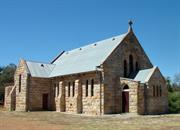
126-128 South Western Hwy Donnybrook
Donnybrook-Balingup
South West
Constructed from 1906
| Type | Status | Date | Documents |
|---|---|---|---|
| State Register | Registered | 14 May 1999 | HCWebsite.Listing+ListingDocument, HCWebsite.Listing+ListingDocument |
| Type | Status | Date | Documents |
|---|---|---|---|
| (no listings) |
| Type | Status | Date | Grading/Management | |
|---|---|---|---|---|
| Category | ||||
| Municipal Inventory | Adopted | 27 Nov 2013 | ||
| Classified by the National Trust | Classified | 01 Oct 1979 | ||
| Aboriginal Heritage Sites Register | Interim | |||
| Name | Type | Year From | Year To |
|---|---|---|---|
| Augustine Benedict Rieusset | Architect | - | - |
| Library Id | Title | Medium | Year Of Publication |
|---|---|---|---|
| 3945 | All Saints Anglican Church Donnybrook, Roof : conservation works. | Heritage Study {Other} | 1999 |
| 4396 | All Saints Anglican Church Donnybrook, Rose Windows : conservation works. | Heritage Study {Other} | 2000 |
| 3672 | All Saints' Church Donnybrook : conservation plan. | Heritage Study {Cons'n Plan} | 1998 |
| 173 | Conservation of All Saints Anglican Church Donnybrook 1990/91 (final report). | Conservation works report | 1992 |
| 7403 | All Saints Anglican Church : architectural evaluation for the Western Australian Heritage Committee. | Heritage Study {Other} | 1989 |
Individual Building or Group
| Epoch | General | Specific |
|---|---|---|
| Present Use | RELIGIOUS | Church, Cathedral or Chapel |
| Original Use | RELIGIOUS | Church, Cathedral or Chapel |
| Style |
|---|
| Federation Gothic |
| Type | General | Specific |
|---|---|---|
| Roof | METAL | Corrugated Iron |
| Wall | STONE | Donnybrook Sandstone |
| General | Specific |
|---|---|
| SOCIAL & CIVIC ACTIVITIES | Religion |
| DEMOGRAPHIC SETTLEMENT & MOBILITY | Settlements |
This information is provided voluntarily as a public service. The information provided is made available in good faith and is derived from sources believed to be reliable and accurate. However, the information is provided solely on the basis that readers will be responsible for making their own assessment of the matters discussed herein and are advised to verify all relevant representations, statements and information.
Constructed from 1906
All Saints' Anglican Church is the oldest public building in Donnybrook and is a very fine example of a building constructed of Donnybrook stone. It is the only Anglican Church building of Donnybrook stone in the south-west and one of a few public buildings of Donnybrook stone in the state. The church is the physical embodiment of the social support given to the local community by the Anglican Church and is a landmark building in the main street of Donnybrook.
All Saints' Anglican Church is a single storey building constructed of Donnybrook stone with a steeply pitched gabled corrugated iron roof. There is a gabled porch at the front of the building and projecting transepts reflect the traditional cruciform plan. The Donnybrook stone is dressed and laid in courses. Buttresses divide the side facades into equal bays which each contain two narrow round arched windows. Internal features include a jarrah ceiling and stained glass windows. There is a large rose window facing east. The foundation stone is inscribed AD MAJORUM DEI GLORIAM HUNC LAPIDEM POSUIT JOHANNES WINTHROP HACKETT LLD XXVII OCT AD 1906.
On 30 March 1880, Rev. Joseph Withers, Rector of Bunbury, held the first Anglican Church service in the Donnybrook district. In 1898, the Parish of Donnybrook was formed and services were held in the Agricultural Hall until mid-1900, when the Congregational Church in Bentley Street (later site of the fire station) was purchased for use as a Mission Hall. The Congregational Union had inaugurated a mission in the district in 1891, and voluntary labour had built the small timber church. In 1901, a building committee was formed and began fund raising to build a new Anglican church. In 1906, architect Augustine Benedict Rieusset (a past President of the Melbourne Architectural and Engineering Association) prepared plans for a new church to be constructed of Donnybrook stone, to be built on land donated by James Egan. On 27 October, Dr. J. Winthrop Hackett, M.L.C., who owned land in the district, laid the foundation stone for All Saints’ Anglican Church. The West Australian (1 Nov. 1907) reported it would be ‘a handsome edifice in the Norman style’ and on its completion would be ‘one of the finest public buildings in the South-West.’ A. Bragg built the church ‘entirely of the famous Donnybrook stone’ (Western Mail 21 Sept. 1907), and it was completed at a cost of about £500. On 29 June 1907, Bishop Goldsmith, of Bunbury, dedicated the Church, ‘one of the most handsome and stately edifices in the Diocese’ (Western Mail ibid) in which donations from England included choir stalls from the village of Rake, Hampshire, a credence table and communion vessels from All Saints, Bloxsom, and other items from Hampshire and Kent. A small rectory of brick construction was built to accommodate the resident Rector. On 24 June 1923, Dr. Wilson, Bishop of Bunbury, dedicated a mural painting and paneling in the Sanctuary. At a cost of about £1,000 ($2,000), it was a substantial gift from the donor. In 1952, Donnybrook received £100 towards extensions for the rectory from the Jubilee Appeal. In 1963, a disused school and hall at Goodwood were purchased and re-located to the church grounds, where it was re-erected and converted for use as a parish hall and Sunday school. In 1999, All Saints’ Anglican Church, a rare example of a church built in Donnybrook stone and the oldest public building in Donnybrook, was Entered on the Register of Heritages Places. In 2012, the Parish Hall was demolished and a new corrugated iron hall has been erected behind the church.
High
Good
| Name | Type | Year From | Year To |
|---|---|---|---|
| Augustine Benedict Rieusset | Architect | - | - |
| Ref ID No | Ref Name | Ref Source | Ref Date |
|---|---|---|---|
| West Australian 1 Nov. 1906, p. 3 & 4 July 1907, p. 4 | 1907 | ||
| Bartlett, Joan Journey: A History of the Anglican Diocese of Western Australia 1904-2004 Anglican Diocese of Bunbury, the Printery, Albany, 2004 , p.77 & p. 138 | 2004 | ||
| Bunbury Herald 24 Oct. 1906, p. 2 | 1906 | ||
| Frost, A. C. Green Gold: A History of Donnybrook W.A. 1842 to 1974 A. C. Frost and Donnybrook Balingup Shire Council, Western Australia, 1976, pp. 170-171 | 1976 | ||
| Western Mail 21 Sept. 1907, p. 28 | 1907 |
| Reserve | Lot/Location | Plan/Diagram | Vol/Folio |
|---|---|---|---|
| Lots 3 and 4 | 1724 | 1492889890 |
| Owner | Category |
|---|---|
| Diocesen Trustees of Bunbury | Church Property |
This information is provided voluntarily as a public service. The information provided is made available in good faith and is derived from sources believed to be reliable and accurate. However, the information is provided solely on the basis that readers will be responsible for making their own assessment of the matters discussed herein and are advised to verify all relevant representations, statements and information.
The building is architecturally significant because it is well proportioned and well executed. It has historic constructional interest also since it was one of the first buildings to use the locally quarried stone. Stone is no longer an economical building material nor is it likely to ever be again and as more are being demolished all the time, few examples as good as this remain.
A large country church constructed of the so-called Donnybrook stone. It features a Rose Window with stained glass infill panels. It is roofed with corrugated iron at a pitch of about 45 degrees.
Assessment 1979 Built 1906 Architect: A.B. Rieusset
This information is provided voluntarily as a public service. The information provided is made available in good faith and is derived from sources believed to be reliable and accurate. However, the information is provided solely on the basis that readers will be responsible for making their own assessment of the matters discussed herein and are advised to verify all relevant representations, statements and information.
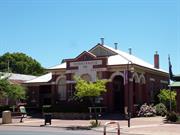
54 South Western Hwy Donnybrook
Lot 32
Donnybrook-Balingup
South West
Constructed from 1898 to 1950
| Type | Status | Date | Documents |
|---|---|---|---|
| State Register | Registered | 02 Sep 1997 | HCWebsite.Listing+ListingDocument, HCWebsite.Listing+ListingDocument |
| Type | Status | Date | Documents |
|---|---|---|---|
| (no listings) |
| Type | Status | Date | Grading/Management | |
|---|---|---|---|---|
| Category | ||||
| Municipal Inventory | Adopted | 27 Nov 2013 | Category 1 | |
| Statewide Post Office Survey | Completed | 01 Mar 1992 | ||
Individual Building or Group
| Epoch | General | Specific |
|---|---|---|
| Present Use | Transport\Communications | Comms: Post or Telegraph Office |
| Original Use | Transport\Communications | Comms: Post or Telegraph Office |
| Style |
|---|
| Federation Free Classical |
| Type | General | Specific |
|---|---|---|
| Wall | BRICK | Common Brick |
| Roof | METAL | Corrugated Iron |
| General | Specific |
|---|---|
| TRANSPORT & COMMUNICATIONS | Telecommunications |
| DEMOGRAPHIC SETTLEMENT & MOBILITY | Settlements |
| TRANSPORT & COMMUNICATIONS | Mail services |
This information is provided voluntarily as a public service. The information provided is made available in good faith and is derived from sources believed to be reliable and accurate. However, the information is provided solely on the basis that readers will be responsible for making their own assessment of the matters discussed herein and are advised to verify all relevant representations, statements and information.
Constructed from 1898, Constructed from 1950
Donnybrook Post Office is a very fine example of a purpose built post office in the Federation Free style and is a landmark in the town centre of Donnybrook. This building has been and continues to be an important part of the life of the community and is an integral part of Donnybrook's past and present mail service and communications. Donnybrook Post Office is comparatively rare as it retains its original roofscape complete with functional ceiling vents flumes & cowls which was a common feature of post offices constructed 1890s to circa 1930.
Donnybrook Post Office is a single-storey red brick building with a hipped corrugated iron roof in the Federation Free Classical style. Contrast is provided by wide bands of painted render. The front facade is symmetrical and is divided into three bays. The central bay projects forward and is parapeted with a plain pediment. This bay has a central arched window with a narrow window on either side. The words "DONNYBROOK POST OFFICE" are painted over the windows. The bays on either side each contain a rendered entrance arch with a keystone. The left hand arch has been filled in with a window. The roof has a wide eaves lines with timber battens. At the left side an additional bay provides an asymmetrical element to the facade. The main roof has a vent in a Dutch gable.
From 1877, Preston Post Office operated from the police station at Minninup, as the district was then known. In October 1894, the townsite of Donnybrook was gazetted. In 1895-96, the local Progress Association requested a new school and post and telegraph offices be built in the vicinity of the railway station. The Public Works Department prepared plans for a post and telegraph building similar to those erected at Dardanup, Harvey and Brunswick, and tenders were called in April 1897. In August, Hough and Donald, of Busselton, were awarded the contract at a cost of £596.18s., and they completed the building on the reserve across the road from the railway station in December. On 13 January 1898, it opened as Donnybrook Post and Telegraph Office, in charge of Miss Mason. In 1912, W. T. Deeble, of Pinjarra, built additions, that included a telephone exchange, at a cost of £1,136.0s.3d. In the post-World War II period, of farming and fruit growing in the district expanded and consequently the volume of postal business increased necessitating enlargement of the Post Office. In 1952, Frank Chappell, of Claremont, completed alterations and additions that included a lunch room, a retiring room, relocation of the telephone exchange, additional post boxes, addition of a room for a technician, and a new toilet block at a cost of £5,617.10s.8d. In 1992-94, some outbuildings were demolished. Since Donnybrook Post Office was sold into private ownership in 1994, the place has continued to serve the postal needs of the Donnybrook community.
Integrity: high, still used for its original and intended purpose of Post Office. Authenticity: moderate to high. A large part of the external fabric is original, although internal modifications are substantial.
Good
| Name | Type | Year From | Year To |
|---|---|---|---|
| George Temple Poole | Architect | - | - |
| Ref ID No | Ref Name | Ref Source | Ref Date |
|---|---|---|---|
| Assessment Document, Donnybrook Post Office, RHP 00727 | |||
| Oldham, Ray and John George Temple Poole: Architect of the Golden Years 1885-1897, University of Western Australia Press, Nedlands | 1980 | ||
| A.C. Frost "Green and Gold" | 1976 | ||
| Bunbury Herald 23 July, 26 Oct. 1897, & 8 Jan | 1898 |
| Ref Number | Description |
|---|---|
| 29 | Municipal Inventory |
| Reserve | Lot/Location | Plan/Diagram | Vol/Folio |
|---|---|---|---|
| Lot 32 |
| Owner | Category |
|---|---|
| G & BL Furze | Other Private |
This information is provided voluntarily as a public service. The information provided is made available in good faith and is derived from sources believed to be reliable and accurate. However, the information is provided solely on the basis that readers will be responsible for making their own assessment of the matters discussed herein and are advised to verify all relevant representations, statements and information.
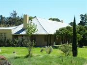
21064 South Western Hwy Mullalyup
Old Mullalyup Inn and Barns
Donnybrook-Balingup
South West
Constructed from 1865
| Type | Status | Date | Documents |
|---|---|---|---|
| State Register | Registered | 02 Jun 1995 | HCWebsite.Listing+ListingDocument, HCWebsite.Listing+ListingDocument |
| Type | Status | Date | Documents |
|---|---|---|---|
| (no listings) |
| Type | Status | Date | Grading/Management | |
|---|---|---|---|---|
| Category | ||||
| Municipal Inventory | Adopted | 27 Nov 2013 | Category 1 | |
| Statewide Hotel Survey | Completed | 01 Nov 1997 | ||
| Classified by the National Trust | Classified | 20 Aug 1979 | ||
| Restrictive Covenant | YES | 01 Jan 1985 | ||
| Register of the National Estate | Permanent | 28 Sep 1982 | ||
| Name | Type | Year From | Year To |
|---|---|---|---|
| John Coverly | Architect | - | - |
| Library Id | Title | Medium | Year Of Publication |
|---|---|---|---|
| 3710 | Brothers on the Blackwood : the story of Thomas Neate Maslin and William Coverley and their part in the history of the Blackwood Inn Mullalyup, Western Australia. | Book | 1998 |
Individual Building or Group
| Epoch | General | Specific |
|---|---|---|
| Original Use | COMMERCIAL | Hotel, Tavern or Inn |
| Other Use | RESIDENTIAL | Single storey residence |
| Present Use | COMMERCIAL | Restaurant |
| Original Use | FARMING\PASTORAL | Stable |
| Style |
|---|
| Old Colonial Georgian |
| Type | General | Specific |
|---|---|---|
| Wall | BRICK | Common Brick |
| Roof | METAL | Corrugated Iron |
| Roof | TIMBER | Shingle |
| General | Specific |
|---|---|
| OUTSIDE INFLUENCES | Water, power, major t'port routes |
| TRANSPORT & COMMUNICATIONS | Road transport |
| DEMOGRAPHIC SETTLEMENT & MOBILITY | Settlements |
| OCCUPATIONS | Hospitality industry & tourism |
This information is provided voluntarily as a public service. The information provided is made available in good faith and is derived from sources believed to be reliable and accurate. However, the information is provided solely on the basis that readers will be responsible for making their own assessment of the matters discussed herein and are advised to verify all relevant representations, statements and information.
Constructed from 1865
Blackwood Inn is a former staging inn, about 150 years old which, together with its outbuildings, (now on a separate title on the opposite side of the road) illustrates the early method of horse transportation and the associated need for closely connected accommodation for travellers, before the railway linked the southern towns and well before the motor car became the predominant method of transportation. Blackwood Inn and Anchor & Hope Inn are the finest remaining stage inns in the district and Blackwood Inn is particularly important because of the existence of surviving outbuildings. Blackwood Inn is a good example of a Victorian Georgian building and is a landmark on the South Western Highway. Its original owner was John Bovell, an important figure in the early history of the district, and it is likely to have accommodated many prominent citizens when it was operating as a staging inn.
Blackwood Inn is a single storey brick building with a hipped corrugated iron roof in the Victorian Georgian style. The building is one room deep with a verandah along the front. It is intact and occupied, though no longer licensed. It is situated in a valley beside a creek and faces the South West Highway. The original roof shingles are still visible under the verandahs. The original outbuildings are across the road and are on a separate title. They consist of three barns. The oldest is of rough jarrah slabs and has lost its roof. The other two barns are of timber, brick and iron and are still used.
Blackwood Inn is located on part of Nelson Location 23, which was taken up by the first settler at Mullalyup, William Coverley (b. 1826; convicted, 1850; arr. April 1853; ticket-of-leave, May 1853; conditional pardon, Jan. 1855, m. Letitia Selby Andrews, August 1855; d. 23 Oct. 1886). In 1860, he and his wife and their two children settled at the farm he named Ellen’s Grove (where a further nine children were born) and the 40 acres of freehold land was registered in his name in 1861. It was later bisected by the Blackwood-road (later South Western Highway) and consequently Coverley’s homestead house and the dairy were on one side of the road and the barn, stable, pigsty and stockyard were on the other side, as shown in a sketch dated 26 March 1880. In November 1881, Thomas Maslin applied for an eating, boarding and lodging house licence that he occupied or intended to occupy on the Blackwood Road, which he and his wife operated at the place. In 1883, Nelson Location 23was transferred to Thomas Maslin. In April 1889, after it was transferred to John Bovell, Police Corporal, of Perth, he gave notice that he was applying for a Wayside House licence for ‘the house and appurtenances … situated at Ellen’s Grove … containing 2 sitting, and 3 bedrooms’ exclusive of those required for his family, that was currently licensed as a Boarding and Lodging House by Thomas Maslin, which he intended to name ‘the Blackwood Inn’, and ‘to keep as an Inn or Public House.’ (Western Mail 18 May 1889, p. 18.) John Bovell (b. County Antrim, 1846, d. Mullalyup, 1900) established the Blackwood Inn as a staging place for road travelers, accommodating visitors to the district and a social centre for local people who enjoyed dances and parties frequently held at the Inn. In 1899, John Bovell acquired further landholdings in the vicinity. After he died in 1900, his widow, Mary Ann Bovell, continued to operate the place as the Blackwood Inn, which was advertised as the ‘Oldest Hotel in the district … a ‘Favourite Resort of Visitors from all over the State’, with fruit from its own orchard and dairy produce from their own cows, horses and vehicles available for hire, ‘Beautiful Scenery’ and a ‘Comfortable Home’. (Western Australia: Garden of the Colony. 1895) Post-World War I, the Inn was operated by Bill Oliver, and later by a man named Palandris. In the 1970s, A. dell’Agostino owned the Blackwood Inn. In the early 2000s, the place continues to be occupied. Together with the Anchor and Hope Inn at Donnybrook, it is the finest remaining staging inn in the Shire. It is especially significant that the outbuildings of the Blackwood Inn are extant.
The place is used for its original and intended use of residence and the use of staging inn is legible. Although some modifications have been made, much of the original fabric remains, including shingles under the corrugated iron roof sheeting.
Good
| Ref ID No | Ref Name | Ref Source | Ref Date |
|---|---|---|---|
| A.C. Frost; " Bayla Balinga" (recollections of Edmund Moore), p 124. | 1979 | ||
| Garden of the Colony | |||
| Heritage Council Report |
| Ref Number | Description |
|---|---|
| 12 | Municipal Inventory |
| Reserve | Lot/Location | Plan/Diagram | Vol/Folio |
|---|---|---|---|
| Lot 4 | D74706 | 1822/757 |
| Owner | Category |
|---|---|
| Melcoast Pty Ltd | Other Private |
This information is provided voluntarily as a public service. The information provided is made available in good faith and is derived from sources believed to be reliable and accurate. However, the information is provided solely on the basis that readers will be responsible for making their own assessment of the matters discussed herein and are advised to verify all relevant representations, statements and information.
This staging Inn. Which is over 100 years old, has a strong historical significance from an age before the motor car, and before the railway linked the southern towns. Along with the Anchor & Hope Inn, it is the finest remaining staging inn and particularly important because of the existence of the surviving barns and outbuildings.
The Blackwood Inn is built of brick has a corrugated iron roof and is one room deep with a verandah along the front. It is intact and occupied by families though it is no longer licensed. The outbuilding across the South Western Highway are also interesting, The oldest is built of rough jarrah slabs but has lost its roof, The two other barns, of timber, brick & iron are still used, The group is particularly well sited in a valley beside a creek.
Assessment 1979 Construction 1865 onwards
This information is provided voluntarily as a public service. The information provided is made available in good faith and is derived from sources believed to be reliable and accurate. However, the information is provided solely on the basis that readers will be responsible for making their own assessment of the matters discussed herein and are advised to verify all relevant representations, statements and information.
1435 Balingup-Nannup Rd Southampton
Spruce Rd, Lewana. (17 km from Balingup). Lot 1.
Lewana Park
Donnybrook-Balingup
South West
Constructed from 1959, Constructed from 1931
| Type | Status | Date | Documents |
|---|---|---|---|
| State Register | Registered | 17 Aug 2012 | HCWebsite.Listing+ListingDocument, HCWebsite.Listing+ListingDocument |
| Type | Status | Date | Documents |
|---|---|---|---|
| (no listings) |
| Type | Status | Date | Grading/Management | |
|---|---|---|---|---|
| Category | ||||
| Municipal Inventory | Adopted | 27 Nov 2013 | Category 1 | |
Lewana is in good condition and has generally been well maintained as tourist accommodation by the current owners. The grounds and cottages are attractive and well maintained albeit with areas of intrusive invasions of some problematic and noxious weeds such as Blackberries. While the homestead house is in fair condition, and is well protected by the wrap around verandah, a number of general maintenance items require attention including the stumps and roof sheeting, some of which were being attended to in July 2011. The barn is in fair to poor condition with rusting roof sheeting and a number of other elements that are missing or require attention.
| Name | Type | Year From | Year To |
|---|---|---|---|
| Forest Department (now CALM) | Architect | 1960 | - |
Individual Building or Group
| Epoch | General | Specific |
|---|---|---|
| Original Use | FORESTRY | Housing or Quarters |
| Original Use | FARMING\PASTORAL | Cottage |
| Other Use | GOVERNMENTAL | Other |
| Present Use | SOCIAL\RECREATIONAL | Other |
| Style |
|---|
| Vernacular |
| Type | General | Specific |
|---|---|---|
| Wall | TIMBER | Weatherboard |
| Roof | METAL | Corrugated Iron |
| Wall | PLASTER | Plasterboard |
| General | Specific |
|---|---|
| SOCIAL & CIVIC ACTIVITIES | Sport, recreation & entertainment |
| DEMOGRAPHIC SETTLEMENT & MOBILITY | Immigration, emigration & refugees |
| OCCUPATIONS | Timber industry |
| OCCUPATIONS | Grazing, pastoralism & dairying |
| DEMOGRAPHIC SETTLEMENT & MOBILITY | Settlements |
| OCCUPATIONS | Hospitality industry & tourism |
This information is provided voluntarily as a public service. The information provided is made available in good faith and is derived from sources believed to be reliable and accurate. However, the information is provided solely on the basis that readers will be responsible for making their own assessment of the matters discussed herein and are advised to verify all relevant representations, statements and information.
Constructed from 1960, Constructed from 1931
Lewana is a picturesque property, where a group of simple vernacular timber buildings are set amongst a wide variety of mature exotic and indigenous tree plantings in a parkland formation, within the wider setting of the scenic Blackwood Valley; the place is an unusually intact former forestry settlement, one of four former forestry settlements converted to a recreation camp in the 1970s before being sold into private ownership, and so far as is known the only such place with an arboretum and extensive plantings of more than 50 varieties of exotic and indigenous trees; the place encompasses and illustrates the European development of the Blackwood Valley from pastoral to farming, then forestry, recreation and tourism, and thus demonstrates the lifestyles of the early settlers and subsequent farmers in the area, the farming opportunities taken by migrant farmers and workers, the development of the timber industry and the lifestyle of the timber workers and their families in the post World War II period to 1976, the types of complementary activities to supplement farming incomes, and the government policy in the late 1970s and 1980s of developing recreation camps to provide affordable accommodation to families to experience the lifestyle of the regional natural resource areas, and now illustrates the kinds of tourism opportunities in the area in the early 2000s; and, the trees planted throughout the place provide an extensive catalogue of productive and decorative exotic species suitable for cultivation in the southern area of the state.
Lewana comprises a homestead house and barn, five forestry cottages, a cabin, a workshop, seven single garages, all constructed of jarrah weatherboard with corrugated iron roofs in the vernacular style, and the concrete floor slab remains of a shop, all set on about 39 ha land, and surrounded by a wide variety of trees planted in the vicinity of the homestead and cottages and in an arboretum and pine plantation, Presently used as a unique holiday and recreational venue for families and small groups. Nestled in a magnificent valley amid lush pine plantations and natural forest next to the Blackwood River, approximately 17 kms from Balingup on the scenic Balingup/Nannup Road, the settlement consists of 5 cottages and the original home and store. This is a very old established farmland area and over the years, before the pine plantations, provided a home and living for families over many decades. "Running Brook" was always a source of fresh spring water vital in the summer months. A concrete and granite wall was built about 200m upstream from the settlement by Jim Anderson from Manjimup, under the supervision of a Water Supply Engineer from Collie. In 1961 the pipeline down to the houses was constructed by Forest Dept employees under the supervision of Harold Pears who was the overseer at that time. This was not an easy task as the terrain was very rough and the pipes were 6m in length and were carried to where they were required on the shoulders of the workers . They were then joined together and in some places 2.5m logs were put under the pipe to keep it level. This was connected direct to the houses and pressure reduction valves had to be used as the pressure was so great.
In c. 1897, John Gillick leased Nelson Location 694, 100 acres in area, part of which was the future site of Lewana. This property on the Balingup-Nannup Road, on the banks of the Blackwood River, became known as Gillick’s. It continued to be known by this name after Robert Smith, who owned Riverton Farm on the opposite side of road, leased it in c. 1916, and purchased it in 1918. In 1926, Robert Smith moved to Nannup, where he managed Kauri Timber Co., leaving his sons, Donald ‘Don’ (aged 22) and Billy (aged 19), residing at Riverton Farm and operating his pastoral property. In 1931, Billy Smith married Hazel Wauchope, and his father built a timber weatherboard house for them at Gillick’s, where they took up residence. Henceforward Billy worked Gillick’s and Don worked Riverton. In the 1940s, Robert Smith leased Gillick’s to Wakelam Bros., earthmoving contractors, who cleared some of the property. During World War II, some Italian migrants were interned and worked on the property. In October 1946, a small portion of Nelson Location 694 was transferred to Donald Garton Smith, and his father retained the balance, which he continued to lease to various tenants. In 1954, Gillick’s was leased to Danish migrant Erik Slyns, who had arrived in Western Australia with his wife and three children in 1949. They took up residence at the homestead and ran dairy cattle, sheep and pigs on the property. In June 1956, portion of Nelson Location 694 was transferred to Wilfred Walter, storekeeper, of Balingup, who was a member of Balingup Road Board (1955-59). In early 1957, he sold it to Erik Slyns, who was recorded as farmer, of “Lewana”, Balingup, indicating it was already known by this name, which is an Aboriginal word for wind. Slyns made additions to the existing dairy was at the rear of the barn building to enable the introduction of mechanised milking, and the milk was sold to the cheese factory in Balingup. He planted a number of trees, including exotic and indigenous species, such as lilly pilly, and fruit trees such as apricots, apples and walnuts, whose produce he sold. In the 1950s, the Forests Department expanded its pine planting programme in the district. In 1959, after Nelson Location 750 was found to be unsuitable for establishment of a forestry settlement, Slyns’ offer to sell 9 acres from his homestead block was accepted. This land was on the lower and flatter contours of the land with a permanent water supply and was already cleared so construction could commence promptly. In 1960, the Department constructed a dam in the creek running through the property, and five Type 8 Forestry houses for forestry workers were relocated to Lewana Settlement, as it was to be known, although Lewana continued in common usage. In 1961, this portion of Nelson Location 694 (Lots 1 and 2 of Diagram 26531) was transferred to the Conservator of Forests; and, a Type 2D Office, Building, an oil store and drum ramp and a five bay garage were erected. In November 1963, a UK 7-2 Type house was erected at Lewana Settlement to accommodate the Officer in Charge (OIC). After Custom Credit foreclosed on Slyns’ mortgage on his portion of Nelson Location 694, it was offered for sale at auction. The sole bid at £500 was from the Forests Department, which subsequently purchased it for £700 in 1964. At Lewana Settlement in 1965, a storage shed was erected and for most of the individual houses a single timber weatherboard garage was erected. In 1969-70, an arboretum was established at Lewana Settlement, with plantings of a number of exotic species including three varieties of poplar (Populus deltoides, P. Alba and P. yunnanensis), European Ash (Fraxinus excelsior), Spanish Chestnut, Sweet Chestnut (Castanea sativa), Tamarisk (Tamarix aphylla), and Cedar (Cedrus). In January 1976, it was decided Lewana Settlement would be closed at the end of the current fire season, and the Estimates for 1976-77 included transfer of House No. 1683 (the UK 7-2 Type house) from Lewana Settlement to Nannup. In August, Overseer Smith and Forestry Worker N. Allen moved to Grimwade, and Lewana Settlement was closed. The place was to be leased to the Community Recreation Council, which leased forestry settlements to provide low cost family holiday homes and alternative camps for youth and sporting organisations. It was decided the eastern boundary of the area leased to Community Recreation Council would be the creek as it would be desirable for the occupiers of the settlement to be able to gain access to it. On 10 October 1976, Community Recreation Council took over occupancy of Lewana Settlement. In mid-2001, ‘Lewana Cottages’, Lots 1 and 2, portion of Nelson Location 694, 29.83 ha. in area, and a second portion of Nelson Location 694, 8.73 ha. in area, was advertised for sale by tender. In 2002, Ben Albert Slyns (younger son of Erik Slyns), who had worked for the Forests Department for a number of years, and his wife, Melody Louise Slyns, purchased Lewana. They took up residence in the homestead house and have continued to operate the place as holiday accommodation, under the name of Lewana Cottages. In c. 2005, a metal construction shed was erected to accommodate a cheese factory operation and outlet for their son’s business, Heritage County.
High
Fair to Good
| Ref Number | Description |
|---|---|
| 44 | Municipal Inventory |
| Reserve | Lot/Location | Plan/Diagram | Vol/Folio |
|---|---|---|---|
| Lot 1 | |||
| Nelson Location 694 |
This information is provided voluntarily as a public service. The information provided is made available in good faith and is derived from sources believed to be reliable and accurate. However, the information is provided solely on the basis that readers will be responsible for making their own assessment of the matters discussed herein and are advised to verify all relevant representations, statements and information.
626 Balingup-Nannup Rd Southampton
Lot 100
Donnybrook-Balingup
South West
Constructed from 1859 to 1970
| Type | Status | Date | Documents |
|---|---|---|---|
| Heritage Agreement | YES | 09 Feb 2000 | HCWebsite.Listing+ListingDocument |
| State Register | Registered | 06 Feb 1998 | HCWebsite.Listing+ListingDocument, HCWebsite.Listing+ListingDocument |
| Type | Status | Date | Documents |
|---|---|---|---|
| (no listings) |
| Type | Status | Date | Grading/Management | |
|---|---|---|---|---|
| Category | ||||
| Municipal Inventory | Adopted | 27 Nov 2013 | Category 1 | |
Poor, all structures in state of disrepair and neglect
| Library Id | Title | Medium | Year Of Publication |
|---|---|---|---|
| 4247 | Ferndale : conservation plan. | Heritage Study {Cons'n Plan} | 1998 |
| 6523 | Ferndale Homestead, Balingup : conservation works report. | Conservation works report | 2003 |
Individual Building or Group
| Epoch | General | Specific |
|---|---|---|
| Original Use | INDUSTRIAL\MANUFACTURING | Dairy, Butter or Cheese Factory |
| Original Use | RESIDENTIAL | Single storey residence |
| Present Use | VACANT\UNUSED | Vacant\Unused |
| Original Use | FARMING\PASTORAL | Homestead |
| Style |
|---|
| Victorian Georgian |
| Type | General | Specific |
|---|---|---|
| Wall | ASBESTOS | Fibrous Cement, flat |
| Roof | METAL | Corrugated Iron |
| Wall | EARTH | Adobe {Mud Brick} |
| Wall | TIMBER | Weatherboard |
| Roof | TIMBER | Shingle |
| General | Specific |
|---|---|
| DEMOGRAPHIC SETTLEMENT & MOBILITY | Workers {incl. Aboriginal, convict} |
| OCCUPATIONS | Grazing, pastoralism & dairying |
This information is provided voluntarily as a public service. The information provided is made available in good faith and is derived from sources believed to be reliable and accurate. However, the information is provided solely on the basis that readers will be responsible for making their own assessment of the matters discussed herein and are advised to verify all relevant representations, statements and information.
Constructed from 1970, Constructed from 1859
The homestead was built on the site of the first piece of land surveyed in the Nelson District. It was taken up by Walter Padbury, (but managed by Mark Padbury, Walter's brother) one of the earliest leaseholders in the district, in 1856. Ferndale demonstrates the lifestyle of the earliest settlers to the area, and contributes to an understanding of early colonial building techniques and farming practices. The combination of aesthetically pleasing simple early colonial buildings in a culturally modified landscaped gives the place a picturesque quality.
Ferndale is a single-storey mud brick and corrugated iron homestead in the Victorian Georgian style, with related outbuildings and a hewn log trough located in a culturally modified landscape setting.
Ferndale, one of the earliest homesteads in the Shire of Donnybrook-Balingup, was built in 1859, by William May for Walter Padbury (b. 1820, arr. 1830, d. 1907), the first European settler to take up land in the Balingup district, namely Location 8 (Ferndale) in 1859, and Location 3 in 1860. James Forrest, father of Sir John Forrest, set out the Victorian Georgian style homestead constructed of mud bricks, with jarrah floors and a shingled roof. To accommodate workers, a 'humpy', a single roomed dwelling, with a fireplace was also constructed of similar materials. Walter Padbury, who was orphaned shortly after his arrival at the Swan River Colony, rose from working as a shepherd to become one of the most successful entrepreneurs in the Colony and was renowned for his philanthropy. He established his brothers, Mark (b. 1822) and Edwin (b. 1811), at Ferndale and (nearby) Brooklands respectively to manage his large holdings in the district. From 1859, Mark resided at Ferndale with his wife, Louisa, and later with his second wife, Charlotte (m. Nov. 1860). Ferndale was initially used mainly for cattle grazing, with some land under tillage. In 1868-1869, large flocks of sheep were introduced. Mark died in 1886, and, in 1887, Walter Padbury sold Ferndale to William Byers Wood, of Bunbury, for £400, who continued to use it for pastoral purposes. In 1906, Ferndale was purchased by W. Catton Grasby, an agricultural writer, and Charles Harper, of Woodbridge, and Dr. H. T Kelsall, and in 1908, his share was assigned to Grasby and Harper. They had a keen interest in fruit growing and fruit trees were planted and a pome (apple and pears) nursery established under nurseryman A. H. Haines, who had trained at Woodbridge. Catton Grasby was responsible for the planting of the first walnut trees at Ferndale. The property manager resided at the homestead. In 1920, the Ferndale property was sub-divided for closer settlement. The homestead Lot was bought by Charles Somerset, who took up residence with his family and continued to use the property mainly for grazing and dairying. In the mid-1930s, a new dairy was built. In 1970, H. C. F. (John) Somerset sold Ferndale to the Forests Department but continued to lease it until 1974. The Forests Department carried out pine planting at Ferndale, and a caretaker resided at the homestead for some years. Subsequently it was vacated and was in a run-down condition in the late 1990s, before being sold to private owners, under whom conservation work was implemented. In 2012, the place is well maintained.
High
Good
| Ref ID No | Ref Name | Ref Source | Ref Date |
|---|---|---|---|
| Nairn, J. Walter Padbury: His Life and Times North Stirling Press, Padbury, W. A | 1985 | ||
| Considine and Griffiths Architects Pty Ltd, with Robin Chinnery, Historian, Ferndale Conservation Plan | 1998 | ||
| Frost, A. C. Baylya- Balinga A History of Balingup, W. A. Donnybrook-Balingup Shire Council, | 1979 |
| Ref Number | Description |
|---|---|
| 32 | Municipal Inventory |
| Reserve | Lot/Location | Plan/Diagram | Vol/Folio |
|---|---|---|---|
| Lot 100 |
| Owner | Category |
|---|---|
| Dept of Conservation & Land Management | State Gov't |
This information is provided voluntarily as a public service. The information provided is made available in good faith and is derived from sources believed to be reliable and accurate. However, the information is provided solely on the basis that readers will be responsible for making their own assessment of the matters discussed herein and are advised to verify all relevant representations, statements and information.
ARCHITECTURAL SIGNIFICANCE The following aspects of the buildings are of significance. (a) The plan form of the two houses and the elevational treatment identifying the place as belonging to the early architectural tradition of the Western Australian country side. (b) The rafter and shingle roofing under the iron cladding and the tie beam.5 visible (c) inside room 1. The coved ripple iron ceiling of rooms 10, 11 and 12. (d) The wide butt jointed floor boards in each of the houses. ll HISTORICAL SIGNIFICANCE Ferndale was one of the earliest houses in the Balingup district. The property was first taken up by Walter Padbury who was prominent in many enterprises throughout the State. Later it was occupied for 50 years by the Somerset family. The house together with the farm buildings demonstrate a past way of life. ll ENVIRONMENTAL IMPORTANCE The homestead and other buildings are set in an impressive landscape with extensive views over the river valley. The houses are set in the remnants of a beautiful garden with numbers of exotic trees, a grove of walnuts and a forest of poplars nearby. E
The homestead complex is adjacent to the junction of Hay Road and the Balingup-Nannup Road. The buildings stand on a flat portion of land high above the spacious flood plains of the Blackwood River. There are a number of exotic trees scattered about the house and a grove of walnut trees at the entrance to the site. The homestead complex consists of two houses set at right angles to each other and almost joined by timber framed additions, a workman's room, a large shed and timber clad farm buildings and stock yards. Rooms 1& 2 (see plan) comprise one house while rooms 6 to 14 comprise the other. Rooms 3, 4 and 5 form a linkage between the two and were apparently added on later. bathroom. Rooms 1and 2 are of Flemish Bond brickwork, painted externally and rendered internally. Room 1has no ceiling and the rafters, close spaced battens and shingles are exposed to view. Room 2 has a boarded coved ceiling. The roof is gabled and the roof covering of Zincalum corrugated iron has recently been fixed to replace and earlier covering. The flooring is 172 mm wide butt jointed boards. The house comprised of room 6 to 14 is of brick walls rendered in a cement render in parts lined out to simulate stonework. The external walls to room 8 are timber framed and contain glass louvres. Rooms 10, 11 and 12 have ripple iron ceilings coved to the shape of the hip roof over. The walls to Room 9 have been battened and lined with fibrous plaster lining with cover battens over the joints. The ceilings are of the same material. Room 6 is fitted out as a bathroom with Tilux sheeting. The roof is corrugated galvanised iron hip roof over the central core - rooms 10, 11 and 12. The pitch of the hip roof is carried down over the minor rooms and vera ndah surrounding the central core - rooms 6, 7, 13 and 14. Room 9 has a hip roof independent of the roofing system described above. THE MA N'S ROOM: The room is of Flemish Bond brickwork about 4m x 4m with a pyramid roof which was shingled some 10 years ago. It is some 80 metres to the south west of the house. THE LARGE SHED: This shed is some 30m x lOm. It is framed up with round poles reminiscent of telegraph poles and is quite high. It has a galvanised corrugated iron roof and galvanised corrugated iron cladding on the side walls, the ends are open. THE FARM BIJILDINGS AND STOCKYARDS: These were not inspected in detail but hoppers constructed on the south face of the building suggest that may have been associated with walnut production. More research into this aspect could uncover interesting material. The buildings are of unpainted weatherboard on timber framing with corrugated galvanised iron roof. The stockyards are of post and rail fencing.
Assessment 1993 Original Owner: Walter Padbury Walter Padbury was one of the first to take up land in the Balingup district. This enterprise was part of a general movement of settlers south from Donnybrook into the Blackwood Valley in late 1850's. Amongst others in its southerly rush were the Hesters, Blechyndens and the Jones. Padbury's land was taken up in parcels between 1859 and 1878. He also took up a pastoral lease of 16,500 ha from which Ferndale and Brooklands was sub-divided. These properties were managed by Padbury's brothers Mark (Ferndale) and Edwin (Brooklands). After the death of Mark Padbury in 1886 Ferndale was sold to W Wood and then to Harper and Grasby. The property was sub-divided into smaller fanns in 1920. Charles Somerset acquired the homestead farm and his family occupied it for 50 years. The house is also known as Somerset House. The Forests Department acquired the property in the early 1970'a for pine plantations and CALM, the Department's successor, has until recently kept a caretaker in residence.
This information is provided voluntarily as a public service. The information provided is made available in good faith and is derived from sources believed to be reliable and accurate. However, the information is provided solely on the basis that readers will be responsible for making their own assessment of the matters discussed herein and are advised to verify all relevant representations, statements and information.