Local Government
Dundas
Region
Goldfields
Norseman
Dundas
Goldfields
| Type | Status | Date | Documents |
|---|---|---|---|
| (no listings) |
| Type | Status | Date | Documents |
|---|---|---|---|
| (no listings) |
| Type | Status | Date | Grading/Management | |
|---|---|---|---|---|
| Category | ||||
| (no listings) | ||||
Individual Building or Group
| Epoch | General | Specific |
|---|---|---|
| Original Use | FARMING\PASTORAL | Homestead |
This information is provided voluntarily as a public service. The information provided is made available in good faith and is derived from sources believed to be reliable and accurate. However, the information is provided solely on the basis that readers will be responsible for making their own assessment of the matters discussed herein and are advised to verify all relevant representations, statements and information.
Norseman
Dundas
Goldfields
Constructed from 1897, Constructed from 1917
| Type | Status | Date | Documents |
|---|---|---|---|
| (no listings) |
| Type | Status | Date | Documents |
|---|---|---|---|
| (no listings) |
| Type | Status | Date | Grading/Management | |
|---|---|---|---|---|
| Category | ||||
| Mining Heritage Study | YES | 30 Jun 1999 | ||
Individual Building or Group
| Epoch | General | Specific |
|---|---|---|
| Original Use | MINING | Other |
| Present Use | MINING | Other |
This information is provided voluntarily as a public service. The information provided is made available in good faith and is derived from sources believed to be reliable and accurate. However, the information is provided solely on the basis that readers will be responsible for making their own assessment of the matters discussed herein and are advised to verify all relevant representations, statements and information.
22 km S of Norseman
22kms south of Norseman
Dundas
Goldfields
Constructed from 1903
| Type | Status | Date | Documents |
|---|---|---|---|
| (no listings) |
| Type | Status | Date | Documents |
|---|---|---|---|
| (no listings) |
| Type | Status | Date | Grading/Management | |
|---|---|---|---|---|
| Category | ||||
| Municipal Inventory | Adopted | 14 Aug 1995 | 5 | |
Historic site
| Epoch | General | Specific |
|---|---|---|
| Present Use | SOCIAL\RECREATIONAL | Other |
| Original Use | GOVERNMENTAL | Reservoir or Dam |
| Other Use | MINING | Other |
| General | Specific |
|---|---|
| OCCUPATIONS | Mining {incl. mineral processing} |
This information is provided voluntarily as a public service. The information provided is made available in good faith and is derived from sources believed to be reliable and accurate. However, the information is provided solely on the basis that readers will be responsible for making their own assessment of the matters discussed herein and are advised to verify all relevant representations, statements and information.
Constructed from 1903
Historic value: Important watering area during early gold mining years when the town was active. Social value: Currently a popular picnic and recreation area.
Natural granite outcrops in natural bush settings with stone built dam. Hand laid and cement jointed catchment walls.
Extent of Original Fabric: 85%
This information is provided voluntarily as a public service. The information provided is made available in good faith and is derived from sources believed to be reliable and accurate. However, the information is provided solely on the basis that readers will be responsible for making their own assessment of the matters discussed herein and are advised to verify all relevant representations, statements and information.
40 km S of Norseman
40kms south of Norseman
Dundas
Goldfields
Constructed from 1925
| Type | Status | Date | Documents |
|---|---|---|---|
| (no listings) |
| Type | Status | Date | Documents |
|---|---|---|---|
| (no listings) |
| Type | Status | Date | Grading/Management | |
|---|---|---|---|---|
| Category | ||||
| Municipal Inventory | Adopted | 14 Aug 1995 | 5 | |
Historic Site
| Epoch | General | Specific |
|---|---|---|
| Other Use | SOCIAL\RECREATIONAL | Other |
| Original Use | GOVERNMENTAL | Reservoir or Dam |
| Present Use | GOVERNMENTAL | Reservoir or Dam |
| General | Specific |
|---|---|
| TRANSPORT & COMMUNICATIONS | Rail & light rail transport |
This information is provided voluntarily as a public service. The information provided is made available in good faith and is derived from sources believed to be reliable and accurate. However, the information is provided solely on the basis that readers will be responsible for making their own assessment of the matters discussed herein and are advised to verify all relevant representations, statements and information.
Constructed from 1925
Historic Value: The dam was built by the government in 1925 to enable steam locomotives operating between Norseman and Salmon Gums to obtain water supplies. McPherson Rock was the camping ground for the teamsters carting between Norseman and Esperence in the 1900's.
Situated 20 miles south of Norseman and 100 metres off the main highway. McPherson's Rcok is situated approximately 400 metres from the dam.
Fair
This information is provided voluntarily as a public service. The information provided is made available in good faith and is derived from sources believed to be reliable and accurate. However, the information is provided solely on the basis that readers will be responsible for making their own assessment of the matters discussed herein and are advised to verify all relevant representations, statements and information.
55km SSW of Norseman
Dundas
Goldfields
| Type | Status | Date | Documents |
|---|---|---|---|
| (no listings) |
| Type | Status | Date | Documents |
|---|---|---|---|
| (no listings) |
| Type | Status | Date | Grading/Management | |
|---|---|---|---|---|
| Category | ||||
| Municipal Inventory | Adopted | 14 Aug 1995 | 5 | |
Historic site
| Epoch | General | Specific |
|---|---|---|
| Present Use | SOCIAL\RECREATIONAL | Other |
| Original Use | GOVERNMENTAL | Reservoir or Dam |
| Original Use | Transport\Communications | Rail: Water Tower |
| Type | General | Specific |
|---|---|---|
| Wall | STONE | Other Stone |
| General | Specific |
|---|---|
| TRANSPORT & COMMUNICATIONS | Rail & light rail transport |
This information is provided voluntarily as a public service. The information provided is made available in good faith and is derived from sources believed to be reliable and accurate. However, the information is provided solely on the basis that readers will be responsible for making their own assessment of the matters discussed herein and are advised to verify all relevant representations, statements and information.
Historic Value: Supplied water for the railways when team was used to power locomotives. Associated with the develoment of the Eastern Goldfields. Social Value: Used as a recreational area.
Large granite tank with stone pitched drainage contour to cultivate drain tank.
Extent of original fabric: 100%
This information is provided voluntarily as a public service. The information provided is made available in good faith and is derived from sources believed to be reliable and accurate. However, the information is provided solely on the basis that readers will be responsible for making their own assessment of the matters discussed herein and are advised to verify all relevant representations, statements and information.
9kms ESE of Norseman Norseman
Dundas
Goldfields
Constructed from 1906
| Type | Status | Date | Documents |
|---|---|---|---|
| (no listings) |
| Type | Status | Date | Documents |
|---|---|---|---|
| RHP - To be assessed | Current | 25 Jun 2004 |
| Type | Status | Date | Grading/Management | |
|---|---|---|---|---|
| Category | ||||
| Municipal Inventory | Adopted | 14 Aug 1995 | 5 | |
Demonstrates the importance of water supply in the goldfields area
High social value as the primary town water supply for Norseman for thirty years 1906 to 1936.
Concrete-lined dam with earth bund. Timber framed corrugated iron roof remains, in very poor condition. The original fabric remains largely intact. The pump-house has been removed, but evidence of the pipeline into Norseman remains. Water collection channels directing water into the dam remain.
The Norseman area was thinly populated by pastoralists from the 1870s. With the discovery of gold in the 1890s, population increased, and towns were established. Norseman townsite was settled in 1894, although it did not become the major centre for the area until the late 1890s, when the town of Dundas was surpassed. Water supply was a constant problem. In the 1890s, a limited number of condensers were used to produce drinking water from the local salt lakes. Run-off from rock gullies in the area was also carted to be sold in Norseman. Number One Dam was constructed in 1906, but problems of water supply remained well into the 1920s. Locals complained at the high cost of water in the district, and the OK mine closed for lack of fresh water. In 1936, a pipeline from Coolgardie to Norseman was constructed, linking the town to the Mundaring Water Supply, reliving the pressure on Number One Dame as primary water supply for the town. However, it continued in use until 1960, when Number Two Dam was built. The dam has been stocked with Gilgies, which can still be caught. The second dam near to Norseman townsite, Tin Dam, was constructed in 1913. It is also a concrete-lined dam with a timber-framed corrugated iron cover but is reported to be in a dangerously poor condition, with it iron sheets rusted and loose.
Historic Site
| Epoch | General | Specific |
|---|---|---|
| Present Use | GOVERNMENTAL | Reservoir or Dam |
| Original Use | GOVERNMENTAL | Reservoir or Dam |
| General | Specific |
|---|---|
| SOCIAL & CIVIC ACTIVITIES | Community services & utilities |
This information is provided voluntarily as a public service. The information provided is made available in good faith and is derived from sources believed to be reliable and accurate. However, the information is provided solely on the basis that readers will be responsible for making their own assessment of the matters discussed herein and are advised to verify all relevant representations, statements and information.
Constructed from 1906
Historic Value: This dam became the principal water supply for Norseman Town and miners until 1960 when the No. 2 dam was built.
Dam set around bushland completely covered by corrugated iron on a timber frame.
Extent of Original Fabric: 95%
Poor
| Owner | Category |
|---|---|
| Waters and Rivers Commission | State Gov't |
| Dep't for Planning & Infrastructure | State Gov't |
This information is provided voluntarily as a public service. The information provided is made available in good faith and is derived from sources believed to be reliable and accurate. However, the information is provided solely on the basis that readers will be responsible for making their own assessment of the matters discussed herein and are advised to verify all relevant representations, statements and information.
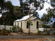
100 Angove St Norseman
Dundas
Goldfields
Constructed from 1898 to 1968
| Type | Status | Date | Documents |
|---|---|---|---|
| State Register | Registered | 25 Nov 2016 | HCWebsite.Listing+ListingDocument, HCWebsite.Listing+ListingDocument |
| Type | Status | Date | Documents |
|---|---|---|---|
| (no listings) |
| Type | Status | Date | Grading/Management | |
|---|---|---|---|---|
| Category | ||||
| Anglican Church Inventory | YES | 31 Jul 1996 | ||
| Municipal Inventory | Adopted | 14 Aug 1995 | 2 | |
| Library Id | Title | Medium | Year Of Publication |
|---|---|---|---|
| 10245 | Holy Trinity Church, Norseman | Heritage Study {Cons'n Plan} | 2014 |
Individual Building or Group
| Epoch | General | Specific |
|---|---|---|
| Original Use | RELIGIOUS | Church, Cathedral or Chapel |
| Original Use | RELIGIOUS | Housing or Quarters |
| Present Use | RELIGIOUS | Church, Cathedral or Chapel |
| Style |
|---|
| Federation Carpenter Gothic |
| Type | General | Specific |
|---|---|---|
| Wall | TIMBER | Weatherboard |
| Roof | METAL | Corrugated Iron |
| General | Specific |
|---|---|
| SOCIAL & CIVIC ACTIVITIES | Religion |
This information is provided voluntarily as a public service. The information provided is made available in good faith and is derived from sources believed to be reliable and accurate. However, the information is provided solely on the basis that readers will be responsible for making their own assessment of the matters discussed herein and are advised to verify all relevant representations, statements and information.
Constructed from 1968, Constructed from 1898
Aesthetic Value: The building remains mistly in it's original condition and makes a significant contribution to the streetscape. It is designed in the Gothic style which was adopted at this time by ecclesaitical societies. Historic Value: Constructed in the midst of the Gold Boom, the church is closely identiifed with the growth of the mining population in Norseman. Social Value: For many years the Church was an important focus for the religious, social and musical culture of the eastern Goldfields.
Single storey, timber framed, CGI clad building, gable CGI roof, central front porch with gable roof, Gothic windows are tall pointed arch windows.
Extent of Original Fabric: Most Authenticity: Most of the original fabric remains intact in it's original form.
Good
| Owner | Category |
|---|---|
| Perth Diocesan Trustees | Church Property |
This information is provided voluntarily as a public service. The information provided is made available in good faith and is derived from sources believed to be reliable and accurate. However, the information is provided solely on the basis that readers will be responsible for making their own assessment of the matters discussed herein and are advised to verify all relevant representations, statements and information.
Battery Rd Norseman
School of Mines
Dundas
Goldfields
Constructed from 1940
| Type | Status | Date | Documents |
|---|---|---|---|
| (no listings) |
| Type | Status | Date | Documents |
|---|---|---|---|
| (no listings) |
| Type | Status | Date | Grading/Management | |
|---|---|---|---|---|
| Category | ||||
| Municipal Inventory | Adopted | 14 Aug 1995 | 2 | |
Individual Building or Group
| Epoch | General | Specific |
|---|---|---|
| Present Use | EDUCATIONAL | Museum |
| Original Use | EDUCATIONAL | Technical School |
| Type | General | Specific |
|---|---|---|
| Wall | ASBESTOS | Fibrous Cement, flat |
| Roof | METAL | Corrugated Iron |
| General | Specific |
|---|---|
| SOCIAL & CIVIC ACTIVITIES | Education & science |
This information is provided voluntarily as a public service. The information provided is made available in good faith and is derived from sources believed to be reliable and accurate. However, the information is provided solely on the basis that readers will be responsible for making their own assessment of the matters discussed herein and are advised to verify all relevant representations, statements and information.
Constructed from 1934
Aesthetic Value: The building remains mostly in it's original condition and makes a significant contribution to the streetscape. Historic Value: Contains historic memorabilia from early mining years. Associated with the development of mining in Norseman. Social Value: Now operates as a museum open to the public preserving and displaying elements of Norseman's history.
The Museum is situated on the east side of the railway line. It is a single storey timber framed building with asbestos walls and a corrugated iron gabled roof. Situated to the back of the building is mining machinery from the early days of Norseman. The Museum inside contains early household equipment and furniture from the early mining years.
Extent of Original Fabric: 100% Authenticity: Most of the original fabric remains intact and in it's original form.
Good
| Owner | Category |
|---|---|
| Shire of Dundas | Local Gov't |
This information is provided voluntarily as a public service. The information provided is made available in good faith and is derived from sources believed to be reliable and accurate. However, the information is provided solely on the basis that readers will be responsible for making their own assessment of the matters discussed herein and are advised to verify all relevant representations, statements and information.
Battery Rd Norseman
Dundas
Goldfields
Constructed from 1906
| Type | Status | Date | Documents |
|---|---|---|---|
| (no listings) |
| Type | Status | Date | Documents |
|---|---|---|---|
| (no listings) |
| Type | Status | Date | Grading/Management | |
|---|---|---|---|---|
| Category | ||||
| Municipal Inventory | Adopted | 14 Aug 1995 | 2 | |
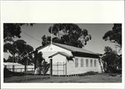
Individual Building or Group
| Epoch | General | Specific |
|---|---|---|
| Present Use | SOCIAL\RECREATIONAL | Other Community Hall\Centre |
| Original Use | COMMERCIAL | Office or Administration Bldg |
| Type | General | Specific |
|---|---|---|
| Roof | METAL | Corrugated Iron |
| Wall | METAL | Corrugated Iron |
| General | Specific |
|---|---|
| SOCIAL & CIVIC ACTIVITIES | Cultural activities |
This information is provided voluntarily as a public service. The information provided is made available in good faith and is derived from sources believed to be reliable and accurate. However, the information is provided solely on the basis that readers will be responsible for making their own assessment of the matters discussed herein and are advised to verify all relevant representations, statements and information.
Constructed from 1906
Aesthetic Value: The building remains mostly in it's original condition and makes a significant contribution to the streetscape. Historic Value: Built in Norseman by the Roads Board, the building was later moved to Salmon Gums and used as an office until the roads in that area were complete, it was then transported back to Norseman and put on it's original site until 1987, when the Lions Vlub took it over and brought it to it's present site.
The club is a single storey small building with timber framing, corrugated iron clad walls and roofing and a covered porch.
Extent of Original Fabric: 100% Authenticity: Most of the original fabric remains intact and it it's original form.
Good
| Owner | Category |
|---|---|
| Norseman Lion's Club | Inc. Non-profit body |
This information is provided voluntarily as a public service. The information provided is made available in good faith and is derived from sources believed to be reliable and accurate. However, the information is provided solely on the basis that readers will be responsible for making their own assessment of the matters discussed herein and are advised to verify all relevant representations, statements and information.
Lot 985 Cornell St Norseman
Dundas
Goldfields
| Type | Status | Date | Documents |
|---|---|---|---|
| (no listings) |
| Type | Status | Date | Documents |
|---|---|---|---|
| RHP - Does not warrant assessment | Current | 24 Apr 2008 |
| Type | Status | Date | Grading/Management | |
|---|---|---|---|---|
| Category | ||||
| (no listings) | ||||
Individual Building or Group
| Epoch | General | Specific |
|---|---|---|
| Original Use | RESIDENTIAL | Single storey residence |
| Present Use | VACANT\UNUSED | Vacant\Unused |
| Type | General | Specific |
|---|---|---|
| Roof | TILE | Other Tile |
| Wall | ASBESTOS | Fibrous Cement, weatherboard |
This information is provided voluntarily as a public service. The information provided is made available in good faith and is derived from sources believed to be reliable and accurate. However, the information is provided solely on the basis that readers will be responsible for making their own assessment of the matters discussed herein and are advised to verify all relevant representations, statements and information.
Denison Dv Norseman
Dundas
Goldfields
Constructed from 1895
| Type | Status | Date | Documents |
|---|---|---|---|
| (no listings) |
| Type | Status | Date | Documents |
|---|---|---|---|
| (no listings) |
| Type | Status | Date | Grading/Management | |
|---|---|---|---|---|
| Category | ||||
| Municipal Inventory | Adopted | 14 Aug 1995 | 2 | |
Historic site
| Epoch | General | Specific |
|---|---|---|
| Present Use | MONUMENT\CEMETERY | Cemetery |
| Original Use | MONUMENT\CEMETERY | Cemetery |
| General | Specific |
|---|---|
| SOCIAL & CIVIC ACTIVITIES | Community services & utilities |
This information is provided voluntarily as a public service. The information provided is made available in good faith and is derived from sources believed to be reliable and accurate. However, the information is provided solely on the basis that readers will be responsible for making their own assessment of the matters discussed herein and are advised to verify all relevant representations, statements and information.
Constructed from 1895
Historic Value: First buriel was in 1895. The cemtary contains grave sites of Norseman's early pioneers.
It is situated 2km out of Norseman and contains various gravestones and markers. The cemetary has been divided into sections, eg, early pioneer, native, catholic etc.
Authenticity: Most of the original fabric is present although in various stages of disrepair.
Poor-Fair
| Owner | Category |
|---|---|
| Shire of Dundas | Local Gov't |
This information is provided voluntarily as a public service. The information provided is made available in good faith and is derived from sources believed to be reliable and accurate. However, the information is provided solely on the basis that readers will be responsible for making their own assessment of the matters discussed herein and are advised to verify all relevant representations, statements and information.
Eyre Hwy 40kms E of Norseman
Dundas
Goldfields
| Type | Status | Date | Documents |
|---|---|---|---|
| (no listings) |
| Type | Status | Date | Documents |
|---|---|---|---|
| (no listings) |
| Type | Status | Date | Grading/Management | |
|---|---|---|---|---|
| Category | ||||
| Municipal Inventory | Adopted | 14 Aug 1995 | 5 | |
Historic Site
| Epoch | General | Specific |
|---|---|---|
| Present Use | OTHER | Other |
| Original Use | OTHER | Other |
| General | Specific |
|---|---|
| OCCUPATIONS | Mining {incl. mineral processing} |
This information is provided voluntarily as a public service. The information provided is made available in good faith and is derived from sources believed to be reliable and accurate. However, the information is provided solely on the basis that readers will be responsible for making their own assessment of the matters discussed herein and are advised to verify all relevant representations, statements and information.
Historic value: An important watering area during the late 1800's for movement of prospectors and station workers. The water holes were covered at one stage to provide a fairly permanent supply of water. Small amounts od gold found in the area in the late 1800's. The granite surounding the area was to be the townsite.
Natural water holes (Gnamma) set in natural granite area, 45kms eat of Norseman.
Very Poor
This information is provided voluntarily as a public service. The information provided is made available in good faith and is derived from sources believed to be reliable and accurate. However, the information is provided solely on the basis that readers will be responsible for making their own assessment of the matters discussed herein and are advised to verify all relevant representations, statements and information.
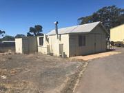
59 Goodliffe St Norseman
Dundas
Goldfields
| Type | Status | Date | Documents |
|---|---|---|---|
| (no listings) |
| Type | Status | Date | Documents |
|---|---|---|---|
| RHP - Does not warrant assessment | Current | 11 Jun 2020 |
| Type | Status | Date | Grading/Management | |
|---|---|---|---|---|
| Category | ||||
| (no listings) | ||||
• The place demonstrates the pattern of historic settlement in the local area; and,
• The place demonstrates the provision of government services in the post-WWII period.
Watercorp Depot, Norseman lies within a mixed residential/light industrial landscape in the Goldfields town of Norseman, part of a larger fenced block containing a number of Watercorp storage facilities. The place consists of a single storey steel frame shed clad in corrugated iron, oriented north-south, adjacent to a newer storage shed oriented east-west. This physical description relates to the original north-south oriented shed. The overall form of the building consists of a single central storage space, a smaller western extension as a living space, with another smaller lean-to constructed along the western edge of the secondary area. The frame of the building consists of tubular metal, topped with steel “I” beams, supporting tubular metal roof frames which in turn support timber roof purlins. The wall frame consists of horizontal timber members to which the cladding is attached; the connection between the timber and metal frames is not apparent.
The Norseman region are the traditional lands of the Ngadju people, small groups of extended families who lived in the area for tens of thousands of years. This way of life began to be disturbed after 1840 with the arrival of Colonial explorers looking for pastoral land for settlement. After the establishment of Port Eucla to the south, Colonial settlers began to move into the area in the 1870s. The area remained sparsely populated until the 1890s with the discovery of gold in the region by William Moir. A substantial gold field was discovered in the area by Laurie Sinclair in 1894, named “Norseman” after his horse. A small gold mining town sprung up in this location by 1896 and the area was proclaimed a municipality. A map of the new settlement in 1897 shows the town had been arranged on a typical grid system, with various reserved for public purposes. On lots 124 and 125, Reserve 3324, a pencil notation describing the area as “Public Utility.” This notation was formalised in the 1906 map of Norseman.
Individual Building or Group
| Type | General | Specific |
|---|---|---|
| Other | ASBESTOS | Other Asbestos |
| Other | TIMBER | Other Timber |
| Roof | METAL | Tin |
This information is provided voluntarily as a public service. The information provided is made available in good faith and is derived from sources believed to be reliable and accurate. However, the information is provided solely on the basis that readers will be responsible for making their own assessment of the matters discussed herein and are advised to verify all relevant representations, statements and information.
Mildura St Norseman
Dundas
Goldfields
Constructed from 1913
| Type | Status | Date | Documents |
|---|---|---|---|
| (no listings) |
| Type | Status | Date | Documents |
|---|---|---|---|
| (no listings) |
| Type | Status | Date | Grading/Management | |
|---|---|---|---|---|
| Category | ||||
| Municipal Inventory | Adopted | 14 Aug 1995 | 5 | |
Historic Site
| Epoch | General | Specific |
|---|---|---|
| Original Use | GOVERNMENTAL | Reservoir or Dam |
| Present Use | GOVERNMENTAL | Reservoir or Dam |
| General | Specific |
|---|---|
| SOCIAL & CIVIC ACTIVITIES | Community services & utilities |
This information is provided voluntarily as a public service. The information provided is made available in good faith and is derived from sources believed to be reliable and accurate. However, the information is provided solely on the basis that readers will be responsible for making their own assessment of the matters discussed herein and are advised to verify all relevant representations, statements and information.
Constructed from 1913
Historic value: Was used as the main storage supply dam to the town in the 1900's and is still used as a water supply to nearby sporting grounds. Associated with the development of Norseman as a mining centre. Social Value: Now used as a recreational area.
Wood structure with tin convering earth dam on the edge of the lake situated on west side of the town. Used to water the recreational grounds.
Extent of Original Fabric: 95%
| Owner | Category |
|---|---|
| Shire of Dundas | Local Gov't |
This information is provided voluntarily as a public service. The information provided is made available in good faith and is derived from sources believed to be reliable and accurate. However, the information is provided solely on the basis that readers will be responsible for making their own assessment of the matters discussed herein and are advised to verify all relevant representations, statements and information.
Neville Pde Norseman
Dundas
Goldfields
Constructed from 1936
| Type | Status | Date | Documents |
|---|---|---|---|
| (no listings) |
| Type | Status | Date | Documents |
|---|---|---|---|
| (no listings) |
| Type | Status | Date | Grading/Management | |
|---|---|---|---|---|
| Category | ||||
| Municipal Inventory | Adopted | 14 Aug 1995 | 2 | |
Individual Building or Group
| Epoch | General | Specific |
|---|---|---|
| Original Use | SOCIAL\RECREATIONAL | Other Community Hall\Centre |
| Present Use | SOCIAL\RECREATIONAL | CWA Hall |
| Type | General | Specific |
|---|---|---|
| Wall | ASBESTOS | Fibrous Cement, flat |
| Roof | METAL | Corrugated Iron |
| General | Specific |
|---|---|
| SOCIAL & CIVIC ACTIVITIES | Sport, recreation & entertainment |
This information is provided voluntarily as a public service. The information provided is made available in good faith and is derived from sources believed to be reliable and accurate. However, the information is provided solely on the basis that readers will be responsible for making their own assessment of the matters discussed herein and are advised to verify all relevant representations, statements and information.
Constructed from 1936
Aesthetic Value: The building remains mostly in it's original condition and makes a significant contributio to the streetscape. Historic Value: Once used for wedding functions and social events. Social Value: Built as restrooms for travellers. Holds CWA meetings and TAFE classes.
Pale blue building built from asbestos cement and iron. Contains several rooms including cloak room and kitchen.
Extent of Original Fabric: Most Authenticity: Most of the original fabric remains intact and in it's original form.
Site Only- demolished due to termite damage.
| Owner | Category |
|---|---|
| Country Women's Association | Inc. Non-profit body |
This information is provided voluntarily as a public service. The information provided is made available in good faith and is derived from sources believed to be reliable and accurate. However, the information is provided solely on the basis that readers will be responsible for making their own assessment of the matters discussed herein and are advised to verify all relevant representations, statements and information.
Off Coolgardie Esperance Hwy Norseman
48kms north of Norseman, close to the abandoned Pioneer Railway Station
Dundas
Goldfields
Constructed from 1910
| Type | Status | Date | Documents |
|---|---|---|---|
| (no listings) |
| Type | Status | Date | Documents |
|---|---|---|---|
| RHP - To be assessed | Current | 25 Jun 2008 |
| Type | Status | Date | Grading/Management | |
|---|---|---|---|---|
| Category | ||||
| Municipal Inventory | Adopted | 14 Aug 1995 | 5 | |
Unusual design for a railway dam
Demonstrates the importance of water supply in the goldfields area
Evidence of processes associated with steam-powered rail transport, no longer practised.
Concrete subterranean dam, almost conical in shape, with earth bund. A large spillway directs run-off from the granite outcrop to the west. Eastern end of the granite catchment area has a rock wall to direct water flow. Some archaeological remnants relating to houses and pump. Overall, the place is in good condition and significantly intact.
The Norseman area was thinly populated by pastoralists from the 1870s. With the discovery of gold in the 1890s, population increased, and towns were established. Water supply was a constant problem. Although the initial mineral boom had subsided by about 1906, a rail link to the area was not constructed until the Coolgardie-Norseman railway was put through in 1909. Pioneer Dam was constructed to provide water for steam drains on this line. Jeff Austin, author of ‘Rails Through the Bush’, believes that it was the most expensive railway dam constructed in WA at the time. At some point, there were also some small houses, a pump house and a water tower at the site. It is not known when these were abandoned and removed. When it was no longer used for railways, it became a general local water source and recreation site.
Good
Historic Site
| Epoch | General | Specific |
|---|---|---|
| Present Use | GOVERNMENTAL | Reservoir or Dam |
| Original Use | GOVERNMENTAL | Reservoir or Dam |
| Type | General | Specific |
|---|---|---|
| Other | CONCRETE | Other Concrete |
| General | Specific |
|---|---|
| TRANSPORT & COMMUNICATIONS | Rail & light rail transport |
This information is provided voluntarily as a public service. The information provided is made available in good faith and is derived from sources believed to be reliable and accurate. However, the information is provided solely on the basis that readers will be responsible for making their own assessment of the matters discussed herein and are advised to verify all relevant representations, statements and information.
Constructed from 1910
Historic Value: Built by the Government to enable steam engines operating between Coolgardie and Kalgoorlie to obtain water supplies. Social value: Now used as a recreational area.
Concrete subterranean dam, almost conical in shape. A large spillway directs run-off from the granite outcrop to the west. Eastern end of of the granite catchment area has a rock wall to direct water flow. Some archaeological remnants relating to houses and pump. Overall the place is in condition and significantly intact.
Extent of Original Fabric: 95%
Good
This information is provided voluntarily as a public service. The information provided is made available in good faith and is derived from sources believed to be reliable and accurate. However, the information is provided solely on the basis that readers will be responsible for making their own assessment of the matters discussed herein and are advised to verify all relevant representations, statements and information.
Cnr Prinsep & Alsopp Sts Norseman
Dundas
Goldfields
Constructed from 1940
| Type | Status | Date | Documents |
|---|---|---|---|
| (no listings) |
| Type | Status | Date | Documents |
|---|---|---|---|
| (no listings) |
| Type | Status | Date | Grading/Management | |
|---|---|---|---|---|
| Category | ||||
| Municipal Inventory | Adopted | 14 Aug 1995 | 2 | |
Individual Building or Group
| Epoch | General | Specific |
|---|---|---|
| Original Use | SOCIAL\RECREATIONAL | Other Community Hall\Centre |
| Present Use | SOCIAL\RECREATIONAL | Other Community Hall\Centre |
| Type | General | Specific |
|---|---|---|
| Wall | ASBESTOS | Fibrous Cement, flat |
| Roof | METAL | Corrugated Iron |
| General | Specific |
|---|---|
| SOCIAL & CIVIC ACTIVITIES | Cultural activities |
This information is provided voluntarily as a public service. The information provided is made available in good faith and is derived from sources believed to be reliable and accurate. However, the information is provided solely on the basis that readers will be responsible for making their own assessment of the matters discussed herein and are advised to verify all relevant representations, statements and information.
Constructed from 1940
Aesthetic Value: The building remains mostly in it's original condition and makes a significant contribution to the streetscape. Historic Value: It is associated with the Girl Guide and Scout Movements.
A single storey timber framed and corrugated iron clad building with a gabled roof and covered porch area.
Extent of Original Fabric: Most Authenticity: Most of the original fabric remains intact and in it's original form.
Fair
This information is provided voluntarily as a public service. The information provided is made available in good faith and is derived from sources believed to be reliable and accurate. However, the information is provided solely on the basis that readers will be responsible for making their own assessment of the matters discussed herein and are advised to verify all relevant representations, statements and information.
Cnr Prinsep & Morgan Sts Norseman
Dundas
Goldfields
Constructed from 1900
| Type | Status | Date | Documents |
|---|---|---|---|
| (no listings) |
| Type | Status | Date | Documents |
|---|---|---|---|
| (no listings) |
| Type | Status | Date | Grading/Management | |
|---|---|---|---|---|
| Category | ||||
| Municipal Inventory | Adopted | 14 Aug 1995 | 2 | |
Individual Building or Group
| Epoch | General | Specific |
|---|---|---|
| Present Use | VACANT\UNUSED | Vacant\Unused |
| Original Use | RESIDENTIAL | Single storey residence |
| Original Use | COMMERCIAL | Shop\Retail Store {single} |
| Type | General | Specific |
|---|---|---|
| Wall | ASBESTOS | Fibrous Cement, flat |
| Roof | METAL | Corrugated Iron |
| General | Specific |
|---|---|
| OCCUPATIONS | Domestic activities |
This information is provided voluntarily as a public service. The information provided is made available in good faith and is derived from sources believed to be reliable and accurate. However, the information is provided solely on the basis that readers will be responsible for making their own assessment of the matters discussed herein and are advised to verify all relevant representations, statements and information.
Constructed from 1900
Aesthetic Value: The building remains mostly in it's original condition and makes a significant contribution to the streetscape.
A single storey timber framed building clad with asbestos cement sheeting with a timber framed verandah and having a corrugated iron gabled roof.
Extent of Original Fabric: Most Authenticity: Most of the original fabric remains intact and in it's original form. Display windows have been boarded up.
Fair
This information is provided voluntarily as a public service. The information provided is made available in good faith and is derived from sources believed to be reliable and accurate. However, the information is provided solely on the basis that readers will be responsible for making their own assessment of the matters discussed herein and are advised to verify all relevant representations, statements and information.
Cnr Prinsep & Ramsey Sts Norseman
Dundas
Goldfields
| Type | Status | Date | Documents |
|---|---|---|---|
| (no listings) |
| Type | Status | Date | Documents |
|---|---|---|---|
| (no listings) |
| Type | Status | Date | Grading/Management | |
|---|---|---|---|---|
| Category | ||||
| Municipal Inventory | Adopted | 14 Aug 1995 | 2 | |
Individual Building or Group
| Epoch | General | Specific |
|---|---|---|
| Present Use | COMMERCIAL | Office or Administration Bldg |
| Original Use | COMMERCIAL | Office or Administration Bldg |
| Type | General | Specific |
|---|---|---|
| Roof | METAL | Corrugated Iron |
| Wall | ASBESTOS | Fibrous Cement, flat |
| General | Specific |
|---|---|
| SOCIAL & CIVIC ACTIVITIES | Government & politics |
This information is provided voluntarily as a public service. The information provided is made available in good faith and is derived from sources believed to be reliable and accurate. However, the information is provided solely on the basis that readers will be responsible for making their own assessment of the matters discussed herein and are advised to verify all relevant representations, statements and information.
Aesthetic Value: The building remains mostly in it's original condition and makes a significant contribution to the streetscape. Historic Value: Dodd House is part of what used to be the Dundas Shire buildings. Social Value: A meeting place for the WA Pensioners League Inc.
A single storey timber frmaed building clad with asbestos cement sheeting and having a corrugated iron hipped roof which has timber brackets at the eaves.
Extent of Original Fabric: 100% Authenticity: Most of the original fabric remains intact and in it's original form.
| Owner | Category |
|---|---|
| Shire of Dundas | Local Gov't |
This information is provided voluntarily as a public service. The information provided is made available in good faith and is derived from sources believed to be reliable and accurate. However, the information is provided solely on the basis that readers will be responsible for making their own assessment of the matters discussed herein and are advised to verify all relevant representations, statements and information.
Cnr Prinsep & Ramsey Sts Norseman
Dept Community Development
Dundas
Goldfields
| Type | Status | Date | Documents |
|---|---|---|---|
| (no listings) |
| Type | Status | Date | Documents |
|---|---|---|---|
| (no listings) |
| Type | Status | Date | Grading/Management | |
|---|---|---|---|---|
| Category | ||||
| Municipal Inventory | Adopted | 14 Aug 1995 | 2 | |
Individual Building or Group
| Epoch | General | Specific |
|---|---|---|
| Original Use | GOVERNMENTAL | Office or Administration Bldg |
| Present Use | GOVERNMENTAL | Office or Administration Bldg |
| Type | General | Specific |
|---|---|---|
| Wall | BRICK | Common Brick |
| Roof | METAL | Corrugated Iron |
| General | Specific |
|---|---|
| SOCIAL & CIVIC ACTIVITIES | Government & politics |
This information is provided voluntarily as a public service. The information provided is made available in good faith and is derived from sources believed to be reliable and accurate. However, the information is provided solely on the basis that readers will be responsible for making their own assessment of the matters discussed herein and are advised to verify all relevant representations, statements and information.
Aesthetic Value: The building remains mostly in it's original condition and makes a significant contribution to the streetscape. Social value: It currently offers developmental services to the community.
A single storey building constructed of brick and having a corrugated iron half gabled roof which has timber brackets at the eaves.
Extent of Original Fabric: Most Authenticity: Most of the original fabric remains intact and in it's original form.
This information is provided voluntarily as a public service. The information provided is made available in good faith and is derived from sources believed to be reliable and accurate. However, the information is provided solely on the basis that readers will be responsible for making their own assessment of the matters discussed herein and are advised to verify all relevant representations, statements and information.