Local Government
Esperance
Region
Goldfields
8 km N of Mt Esmond
Esperance
Goldfields
Constructed from 1880
| Type | Status | Date | Documents |
|---|---|---|---|
| (no listings) |
| Type | Status | Date | Documents |
|---|---|---|---|
| (no listings) |
| Type | Status | Date | Grading/Management | |
|---|---|---|---|---|
| Category | ||||
| Municipal Inventory | Adopted | 23 Jul 1996 | ||
| Local Heritage Survey | Adopted | 27 Apr 2021 | Some/Moderate significance | |
Historic site
| Epoch | General | Specific |
|---|---|---|
| Original Use | FARMING\PASTORAL | Other |
| Present Use | VACANT\UNUSED | Vacant\Unused |
| General | Specific |
|---|---|
| OCCUPATIONS | Grazing, pastoralism & dairying |
This information is provided voluntarily as a public service. The information provided is made available in good faith and is derived from sources believed to be reliable and accurate. However, the information is provided solely on the basis that readers will be responsible for making their own assessment of the matters discussed herein and are advised to verify all relevant representations, statements and information.
Constructed from 1880
Kangawarrie tank is a large rectangular stone structure sunk below ground leveL The walls are approximately 3m high. In the vicinity. situated in the larger of two grass plains near the Russel Range, are the stone remains of a building which was never completed. The ruins of the cottage are set amongst the trees.
The area was used to shepherd sheep. being only 15 kilometres from the main homestead on a well watered and grassed road J P Brooks started to build a house there. which was never completed. Piles of building stone and sand can still be seen.
Integrity: All Modifications: None
| Ref ID No | Ref Name | Ref Source | Ref Date |
|---|---|---|---|
| DOLA File 2348/991: Pt Reserve ..J.1934, | "Conservation of Flora and Fauna". | National Parks and Nature Conservation Authority. |
| Owner | Category |
|---|---|
| Crown Land | Commonwealth Gov't |
This information is provided voluntarily as a public service. The information provided is made available in good faith and is derived from sources believed to be reliable and accurate. However, the information is provided solely on the basis that readers will be responsible for making their own assessment of the matters discussed herein and are advised to verify all relevant representations, statements and information.
Coolgardie-Esperance Hwy 40km West of Salmon Gums
Esperance
Goldfields
| Type | Status | Date | Documents |
|---|---|---|---|
| (no listings) |
| Type | Status | Date | Documents |
|---|---|---|---|
| (no listings) |
| Type | Status | Date | Grading/Management | |
|---|---|---|---|---|
| Category | ||||
| Register of the National Estate | Registered | 21 Mar 1978 | ||
Landscape
| Epoch | General | Specific |
|---|---|---|
| Original Use | PARK\RESERVE | Park\Reserve |
| General | Specific |
|---|---|
| SOCIAL & CIVIC ACTIVITIES | Sport, recreation & entertainment |
| OCCUPATIONS | Timber industry |
This information is provided voluntarily as a public service. The information provided is made available in good faith and is derived from sources believed to be reliable and accurate. However, the information is provided solely on the basis that readers will be responsible for making their own assessment of the matters discussed herein and are advised to verify all relevant representations, statements and information.
Merivale Rd Boyatup
Thomas River 115 km E of Esperance
Lyndburn Station
Thomas River Station Homestead
Esperance
Goldfields
Constructed from 1872, Constructed from 2004
| Type | Status | Date | Documents |
|---|---|---|---|
| State Register | Registered | 14 Jul 2006 | HCWebsite.Listing+ListingDocument, HCWebsite.Listing+ListingDocument |
| Type | Status | Date | Documents |
|---|---|---|---|
| (no listings) |
| Type | Status | Date | Grading/Management | |
|---|---|---|---|---|
| Category | ||||
| Register of the National Estate | Indicative Place | |||
| Classified by the National Trust | Classified | 11 Jun 1973 | ||
| Municipal Inventory | Adopted | 23 Jul 1996 | ||
| Local Heritage Survey | Adopted | 27 Apr 2021 | Exceptional significance | |
Prior to conservation works in 1986, Lynburn Homestead and Shearing Shed (fmr) was deteriorating to a ruin, with both buildings having lost their roofs. In 2000, when the conservation plan was completed, the buildings were vacant, with corrugated iron roofs in place. The homestead was a ruin, with timberwork charred by fire, unprotected walls in a state of collapse, floors and ceilings missing, stonework severely fretted in places, much timber joinery no longer extant, and blown sand and vegetation covering the interior. Conservation works for the shearing shed began in the late 1970s, well before conservation work began on the homestead. In 2000, when the conservation plan was completed, the shearing shed was in poor condition, with small chute openings in the wall sin partial collapse and stonework severely fretted in parts. Subsidence had caused cracks in the gable wall, the stone in the southwest corner was deteriorating rapidly due to water overflowing from a gutter outlet, and much of the joinery was missing. Conservation works including re-roofing and stabilisation were completed in early 2004.
| Library Id | Title | Medium | Year Of Publication |
|---|---|---|---|
| 5921 | Off-shears : the story of shearing sheds in Western Australia. | Book | 2002 |
| 4648 | Thomas River Station: East Esperance : conservation plan. | Heritage Study {Cons'n Plan} | 2000 |
| 9785 | Lynburn homestead and shearing shed. | Conservation works report | 2011 |
| 7043 | Lynburn Homestead, Thomas River : conservation works (report upon works completed). | Conservation works report | 2004 |
Individual Building or Group
| Epoch | General | Specific |
|---|---|---|
| Original Use | FARMING\PASTORAL | Homestead |
| Original Use | FARMING\PASTORAL | Shed or Barn |
| Original Use | MONUMENT\CEMETERY | Grave |
| Present Use | VACANT\UNUSED | Vacant\Unused |
| Style |
|---|
| Victorian Georgian |
| Vernacular |
| Type | General | Specific |
|---|---|---|
| Wall | STONE | Sandstone, other |
| Roof | METAL | Corrugated Iron |
| General | Specific |
|---|---|
| OCCUPATIONS | Grazing, pastoralism & dairying |
| PEOPLE | Early settlers |
This information is provided voluntarily as a public service. The information provided is made available in good faith and is derived from sources believed to be reliable and accurate. However, the information is provided solely on the basis that readers will be responsible for making their own assessment of the matters discussed herein and are advised to verify all relevant representations, statements and information.
Constructed from 1889, Constructed from 1872
This simple settlers cottage was located on very fertile soil in a very pretty setting. Situated in a valley six kilometres from sea. it was on the original telegraph line track to Israelite. The old doorways were tiny, and the house consisted of a vestibule. kitchen. sitting room. four bedrooms and a verandah. A substantial stone shearing shed is located nearby. Nearby is the grave of Dennis Dunn who died in 1890 when he was 10 months old. His father was Andrew, the Station Master.
The original owner. Mr Campbell Taylor. was the first to take up land at the Oldfield River. west of Esperance and later at Thomas River (April 1870), His pioneering move to graze sheep in the area encouraged other settlers to come. Wool was shipped out from nearby Tagon Harbour despite no landing facilities, He died tragically after a buggy accident in 1900. His early death was a reminder of the hardship and isolation of the pioneers' lives. In 1915 the property was owned by the Turnbulls (Alex and Marion - nee Lee-Steere) and a policeman lived on it from 1926-28. It was abandoned in the 1930s but was owned and worked by the Chopin family from 1932 to about 1940, Mrs Chopin's maiden name was Dorothy Baesjon.
Integrity: Floors and verandahs, windows and doors all gone. Cellar virtually gone. Shearing Shed re-roofed and half re-floored. Modifications: Roof (thatching burned and now iron). No verandah now.
Fair
| Owner | Category |
|---|---|
| G&PGrewar | Other Private |
This information is provided voluntarily as a public service. The information provided is made available in good faith and is derived from sources believed to be reliable and accurate. However, the information is provided solely on the basis that readers will be responsible for making their own assessment of the matters discussed herein and are advised to verify all relevant representations, statements and information.
Loc 8 Neridup Cape Arid
Esperance
Goldfields
Constructed from 1903
| Type | Status | Date | Documents |
|---|---|---|---|
| (no listings) |
| Type | Status | Date | Documents |
|---|---|---|---|
| (no listings) |
| Type | Status | Date | Grading/Management | |
|---|---|---|---|---|
| Category | ||||
| Municipal Inventory | Adopted | 23 Jul 1996 | ||
| Local Heritage Survey | Adopted | 27 Apr 2021 | Some/Moderate significance | |
| Name | Type | Year From | Year To |
|---|---|---|---|
| John A Baesjou | Architect | - | - |
Individual Building or Group
| Epoch | General | Specific |
|---|---|---|
| Original Use | FARMING\PASTORAL | Homestead |
| Present Use | FARMING\PASTORAL | Homestead |
| Type | General | Specific |
|---|---|---|
| Other | STONE | Other Stone |
| General | Specific |
|---|---|
| DEMOGRAPHIC SETTLEMENT & MOBILITY | Settlements |
This information is provided voluntarily as a public service. The information provided is made available in good faith and is derived from sources believed to be reliable and accurate. However, the information is provided solely on the basis that readers will be responsible for making their own assessment of the matters discussed herein and are advised to verify all relevant representations, statements and information.
Constructed from 1903
Located in a beautiful setting in a fold in the hills of Mount Arid, the homestead was situated between the runoff from two creeks, so water was not a problem. The views from the front verandah and hill behind the house are of bays and islands. The house overlooked the road in and the cropping areas. A large iron and timber shed was built down near the paddocks.
The station was founded by the son-in-law of one of the Ponton Brothers in 1903 who was the first to settle at Point Malcolm, east of Cape Arid. After discovering and establishing Balladouia and after the death of his only brother, he started a new farm at Arid called Gabtoobich. It was established together with Hill Springs. The late Amy Crocker, (Balladonia painter and historian) is Jack Baesjou's daughter who spent her childhood there before moving to inland Deralinya in 1910.
Integrity: Remains of stone dining room, fireplace. Modifications: Burnt in mid 1920's only stone walls of kitchen remain.
Very Poor
| Name | Type | Year From | Year To |
|---|---|---|---|
| John A Baesjou | Architect | - | - |
| Ref ID No | Ref Name | Ref Source | Ref Date |
|---|---|---|---|
| A Crocker; "Historic Writings". | |||
| CALM; "Hill Springs leaflet". | CALM |
| Owner | Category |
|---|---|
| CALM | State Gov't |
This information is provided voluntarily as a public service. The information provided is made available in good faith and is derived from sources believed to be reliable and accurate. However, the information is provided solely on the basis that readers will be responsible for making their own assessment of the matters discussed herein and are advised to verify all relevant representations, statements and information.
Loc 9 Neridup Cape Arid
Esperance
Goldfields
Constructed from 1903
| Type | Status | Date | Documents |
|---|---|---|---|
| (no listings) |
| Type | Status | Date | Documents |
|---|---|---|---|
| (no listings) |
| Type | Status | Date | Grading/Management | |
|---|---|---|---|---|
| Category | ||||
| Municipal Inventory | Adopted | 23 Jul 1996 | ||
| Local Heritage Survey | Adopted | 27 Apr 2021 | Some/Moderate significance | |
| Name | Type | Year From | Year To |
|---|---|---|---|
| William Ponton | Architect | - | - |
Individual Building or Group
| Epoch | General | Specific |
|---|---|---|
| Original Use | FARMING\PASTORAL | Homestead |
| Present Use | FARMING\PASTORAL | Homestead |
| Type | General | Specific |
|---|---|---|
| Other | STONE | Limestone |
| General | Specific |
|---|---|
| DEMOGRAPHIC SETTLEMENT & MOBILITY | Settlements |
This information is provided voluntarily as a public service. The information provided is made available in good faith and is derived from sources believed to be reliable and accurate. However, the information is provided solely on the basis that readers will be responsible for making their own assessment of the matters discussed herein and are advised to verify all relevant representations, statements and information.
Constructed from 1903
The house was situated in a large clearing where two creeks met at the back of Mount Arid. The house overlooked Mount Arid. The property had very good soil and plenty of water. The area was fairly heavily timbered.
The property was established by a pioneering gentleman when he was in his sixties. after a lifetime of discovering. establishing and building stations from Albany to Balladonia. He continued developing his farm and his son in law's farm. Hill Springs next door. until his death in 1909.
Integrity: Stone walls remain. Everything else destroyed by fire.
Very Poor
| Name | Type | Year From | Year To |
|---|---|---|---|
| William Ponton | Architect | 1903 | - |
| Ref ID No | Ref Name | Ref Source | Ref Date |
|---|---|---|---|
| AE Crockers; "Bibliography". |
| Owner | Category |
|---|---|
| CALM | State Gov't |
This information is provided voluntarily as a public service. The information provided is made available in good faith and is derived from sources believed to be reliable and accurate. However, the information is provided solely on the basis that readers will be responsible for making their own assessment of the matters discussed herein and are advised to verify all relevant representations, statements and information.
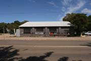
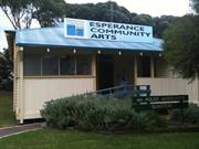
Lot 1018 Norseman Rd Chadwick
Old Cannery Arts Centre/Hunts Cannery
Youth Centre
Esperance
Goldfields
Constructed from 1948
| Type | Status | Date | Documents |
|---|---|---|---|
| State Register | Registered | 09 Feb 2016 | HCWebsite.Listing+ListingDocument, HCWebsite.Listing+ListingDocument |
| Type | Status | Date | Documents |
|---|---|---|---|
| (no listings) |
| Type | Status | Date | Grading/Management | |
|---|---|---|---|---|
| Category | ||||
| Local Heritage Survey | Adopted | 27 Apr 2021 | Some/Moderate significance | |
| Municipal Inventory | Adopted | 23 Jul 1996 | ||
Esperance Fish Cannery (fmr) is an important reminder of the efforts to rebuilt WA's economy after World War II.
The building is a single storey brick and corrugated iron utilitarian building in the Post-War International style.
The cannery was constructed in 1948 (reportably in just one week) for Daniel Samuel Hunt. It was built for the canning of fish. As a regional industry, it provided jobs for the local people as well as returned servicemen, and also contibuted to the rebuilding and reconstruction of WA's post-war economy.
| Library Id | Title | Medium | Year Of Publication |
|---|---|---|---|
| 10207 | Fishing for a living: The estuarine and beach fisheries of the Western Australian south coast. | Electronic | 1992 |
Individual Building or Group
| Epoch | General | Specific |
|---|---|---|
| Other Use | SOCIAL\RECREATIONAL | Other |
| Present Use | SOCIAL\RECREATIONAL | Other Community Hall\Centre |
| Original Use | INDUSTRIAL\MANUFACTURING | Cannery |
| Type | General | Specific |
|---|---|---|
| Wall | BRICK | Common Brick |
| Roof | METAL | Corrugated Iron |
| General | Specific |
|---|---|
| OCCUPATIONS | Manufacturing & processing |
This information is provided voluntarily as a public service. The information provided is made available in good faith and is derived from sources believed to be reliable and accurate. However, the information is provided solely on the basis that readers will be responsible for making their own assessment of the matters discussed herein and are advised to verify all relevant representations, statements and information.
Constructed from 1948
05056 Esperance Fish Cannery (fmr)
The cannery is roughly built and was compleled in one week. The building measures 18 metres square and has large wooden trusses to support the roof. It is situated on Norseman Road overlooking the Bay and in close proximity to the Tanker Jetty. The floor (concrete) in the front half of the building still slopes considerably towards the sea. There was originally a large drain here as the fish were tipped onto the floor and hosed down etc and effluent ran straight out to the sea.
A contemporary opinion of the time was that Dan Hunt built the cannery to forestall the entry of 'snap freeze' operations into the area. Hunt thought it worthwhile to build this cannery in 1948. Herring, garfish, salmon and sardines were processed. Much of this was brought in from the eastern fishing grounds over very poor roads. Fisheries Road is named due to this. A road was made through the bush with a Bren Gun Carrier as far as Israelite Bay. A Stuart tank was then used to go over the sand hills to the beach. After only one year operations ceased due to insufficient supplies of fish. The fishing industry in Esperance seems to go through this same process. still with insufficient stocks offish. The building is now an excellent Arts Centre with fine facilities as extra studios have been built.
Integrity: Walls, trusses, half floor, some original windows, other windows enlarged Modifications: Internal walls, wooden floor in half of the building.
Good
| Ref ID No | Ref Name | Ref Source | Ref Date |
|---|---|---|---|
| Jimmy Wills; "Shire Records". |
| Owner | Category |
|---|---|
| Shire of Esperance | Local Gov't |
This information is provided voluntarily as a public service. The information provided is made available in good faith and is derived from sources believed to be reliable and accurate. However, the information is provided solely on the basis that readers will be responsible for making their own assessment of the matters discussed herein and are advised to verify all relevant representations, statements and information.
Lot 1018 Norseman Rd Chadwick
Esperance
Goldfields
| Type | Status | Date | Documents |
|---|---|---|---|
| (no listings) |
| Type | Status | Date | Documents |
|---|---|---|---|
| (no listings) |
| Type | Status | Date | Grading/Management | |
|---|---|---|---|---|
| Category | ||||
| Municipal Inventory | Adopted | 23 Jul 1996 | ||
05056 Esperance Fish Cannery (fmr)
Tree
| Epoch | General | Specific |
|---|---|---|
| Original Use | PARK\RESERVE | Park\Reserve |
| Present Use | PARK\RESERVE | Park\Reserve |
This information is provided voluntarily as a public service. The information provided is made available in good faith and is derived from sources believed to be reliable and accurate. However, the information is provided solely on the basis that readers will be responsible for making their own assessment of the matters discussed herein and are advised to verify all relevant representations, statements and information.
The unusual twisted tree is of heritage value. It is a reminder of the natural environment and of a natural phenomenon. The tree has been growing under stress.
The interesting feature of this tree is its twisted limb. The tree is a Eucalyptus platypus, and is situated 6 - 8 metres from the Cannery Arts Centre in a prominent position.
Very good
| Reserve | Lot/Location | Plan/Diagram | Vol/Folio |
|---|---|---|---|
| 34219 | Lot 912 |
This information is provided voluntarily as a public service. The information provided is made available in good faith and is derived from sources believed to be reliable and accurate. However, the information is provided solely on the basis that readers will be responsible for making their own assessment of the matters discussed herein and are advised to verify all relevant representations, statements and information.
Stokes Inlet Rd, Stokes Inlet via Coomalbidgup
Esperance
Goldfields
| Type | Status | Date | Documents |
|---|---|---|---|
| (no listings) |
| Type | Status | Date | Documents |
|---|---|---|---|
| (no listings) |
| Type | Status | Date | Grading/Management | |
|---|---|---|---|---|
| Category | ||||
| Register of the National Estate | Registered | 20 May 2003 | ||
| Register of the National Estate | Interim | 20 May 2003 | ||
Large Conservation Region
| Epoch | General | Specific |
|---|---|---|
| Present Use | PARK\RESERVE | Park\Reserve |
| Original Use | OTHER | Other |
This information is provided voluntarily as a public service. The information provided is made available in good faith and is derived from sources believed to be reliable and accurate. However, the information is provided solely on the basis that readers will be responsible for making their own assessment of the matters discussed herein and are advised to verify all relevant representations, statements and information.
Lot 500 Murray Road Dalyup
Lot 500 on Plan 73450
Dempsters' Mainbenup Sheep Dip
Dempsters' Sheep Dip
Esperance
Goldfields
| Type | Status | Date | Documents |
|---|---|---|---|
| (no listings) |
| Type | Status | Date | Documents |
|---|---|---|---|
| (no listings) |
| Type | Status | Date | Grading/Management | |
|---|---|---|---|---|
| Category | ||||
| Local Heritage Survey | Adopted | 27 Apr 2021 | Some/Moderate significance | |
Historic Site
| Epoch | General | Specific |
|---|---|---|
| Original Use | FARMING\PASTORAL | Other |
| Present Use | VACANT\UNUSED | Vacant\Unused |
| Type | General | Specific |
|---|---|---|
| Wall | CONCRETE | Other Concrete |
| Other | STONE | Other Stone |
This information is provided voluntarily as a public service. The information provided is made available in good faith and is derived from sources believed to be reliable and accurate. However, the information is provided solely on the basis that readers will be responsible for making their own assessment of the matters discussed herein and are advised to verify all relevant representations, statements and information.
Constructed from 1903
It is significant in exhibiting particular aesthetic characteristics. It is significant in the evolution or pattern of the history of the local district. It has demonstrable potential to yield information that will contribute to an understanding of the natural or cultural history of the local district.
Little is recorded about this site, however a limited oral history survives, and the fact that it is commonly referred to as the “Dempsters’ Sheep Dip” indicates an association with the Dempster Brothers.(1297) In 1864, the Dempster Brothers had established their first homestead in the area to the northeast of this site a little under a mile away which was known as Mainbenup, although the conditions at this site were less favourable for living when compared with their Esperance Bay holdings and what we now know today as Dempster Homestead, the first stage of which was built later in 1867.(1298) Dipping at that time was a common enough practice for treating ‘scab’, ticks and other ailments in sheep, and a sheep dip of some kind would likely have been constructed in this area circa the 1864 settlement period, however this particular ‘island’ design does not appear to have been commonly used in Australia until circa the 1900’s.(1299, 1300) The absence of this pronounced and easily recognisable feature on any of the early surveys indicates that construction took place during the latter time period, and an article published in 1903 seems to support this, stating that the “...Messrs Dempster Bros... [have] just completed a large and up-to-date sheep dip”, though the exact site of this is not recorded with the article simply referring to their expansive Esperance holdings.(1301) For further information see below - Place No. 12 https://www.esperance.wa.gov.au/local-heritage-survey
Integrity: N/A Authenticity: High
Fair
| Reserve | Lot/Location | Plan/Diagram | Vol/Folio |
|---|---|---|---|
| Lot 500 | 73450 | 2867/195 |
This information is provided voluntarily as a public service. The information provided is made available in good faith and is derived from sources believed to be reliable and accurate. However, the information is provided solely on the basis that readers will be responsible for making their own assessment of the matters discussed herein and are advised to verify all relevant representations, statements and information.
Andrew & Dempster Sts Esperance
In Old Esperance Primary School Grounds/RSL Building
Esperance
Goldfields
Constructed from 1897, Constructed from 1896
| Type | Status | Date | Documents |
|---|---|---|---|
| (no listings) |
| Type | Status | Date | Documents |
|---|---|---|---|
| (no listings) |
| Type | Status | Date | Grading/Management | |
|---|---|---|---|---|
| Category | ||||
| Local Heritage Survey | Adopted | 27 Apr 2021 | Some/Moderate significance | |
| Municipal Inventory | Adopted | 23 Jul 1996 | ||
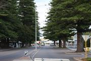
18402 Esperance RSL Building, Norfolk Island Pine Trees and War Memorial
Tree
| Epoch | General | Specific |
|---|---|---|
| Present Use | OTHER | Other |
| Original Use | OTHER | Other |
| General | Specific |
|---|---|
| DEMOGRAPHIC SETTLEMENT & MOBILITY | Settlements |
This information is provided voluntarily as a public service. The information provided is made available in good faith and is derived from sources believed to be reliable and accurate. However, the information is provided solely on the basis that readers will be responsible for making their own assessment of the matters discussed herein and are advised to verify all relevant representations, statements and information.
Constructed from 1896, Constructed from 1897
The tall Norfolk Pine trees lining the streets of Esperance are an impressive feature of the town. The Municipal Council planted 12 trees in Dempster Street, from Andrew to James Streets. in 1897. A photo dated 1915 shows some trees surviving. A street plaque says '1902'. If a tree died. it was replaced by another. These were grown at various times from 1896-1904-1915-1920-1929.
Three trees, one Norfolk Pine, one Sugar Gum and one unknown species, were planted on the corner of Dempster and Andrew Streets in 1896. The Norfolk Pine survived and is outside the present day Australia Post building which is on the site of the first Post and Telegraph building. The other Norfolk Pine trees were planted in 1897.
Integrity: All
Good
| Ref ID No | Ref Name | Ref Source | Ref Date |
|---|---|---|---|
| CJ Daws; " |
| Owner | Category |
|---|---|
| Shire of Esperance | Local Gov't |
This information is provided voluntarily as a public service. The information provided is made available in good faith and is derived from sources believed to be reliable and accurate. However, the information is provided solely on the basis that readers will be responsible for making their own assessment of the matters discussed herein and are advised to verify all relevant representations, statements and information.
23 Andrew St Esperance
Cnr Dempster & Andrew Sts
Esperance
Goldfields
Constructed from 1895 to 1896
| Type | Status | Date | Documents |
|---|---|---|---|
| (no listings) |
| Type | Status | Date | Documents |
|---|---|---|---|
| (no listings) |
| Type | Status | Date | Grading/Management | |
|---|---|---|---|---|
| Category | ||||
| (no listings) | ||||
Individual Building or Group
| Epoch | General | Specific |
|---|---|---|
| Present Use | Transport\Communications | Comms: Post or Telegraph Office |
| Original Use | Transport\Communications | Comms: Post or Telegraph Office |
| Type | General | Specific |
|---|---|---|
| Roof | METAL | Corrugated Iron |
| Wall | STONE | Granite |
This information is provided voluntarily as a public service. The information provided is made available in good faith and is derived from sources believed to be reliable and accurate. However, the information is provided solely on the basis that readers will be responsible for making their own assessment of the matters discussed herein and are advised to verify all relevant representations, statements and information.
29 Andrew St Esperance
Esperance
Goldfields
Constructed from 1963 to 1996
| Type | Status | Date | Documents |
|---|---|---|---|
| (no listings) |
| Type | Status | Date | Documents |
|---|---|---|---|
| (no listings) |
| Type | Status | Date | Grading/Management | |
|---|---|---|---|---|
| Category | ||||
| Anglican Church Inventory | YES | 31 Jul 1996 | ||
Individual Building or Group
| Epoch | General | Specific |
|---|---|---|
| Original Use | RELIGIOUS | Housing or Quarters |
| Original Use | RELIGIOUS | Church, Cathedral or Chapel |
| Original Use | RELIGIOUS | Church Hall |
| Present Use | RELIGIOUS | Church Hall |
| Present Use | RELIGIOUS | Housing or Quarters |
| Type | General | Specific |
|---|---|---|
| Roof | TILE | Cement Tile |
| Wall | BRICK | Common Brick |
| Roof | METAL | Zincalume |
| General | Specific |
|---|---|
| SOCIAL & CIVIC ACTIVITIES | Religion |
This information is provided voluntarily as a public service. The information provided is made available in good faith and is derived from sources believed to be reliable and accurate. However, the information is provided solely on the basis that readers will be responsible for making their own assessment of the matters discussed herein and are advised to verify all relevant representations, statements and information.
Balladonia-Mt Ragged Rd Esperance
Gauroojendinya
Esperance
Goldfields
Constructed from 1874
| Type | Status | Date | Documents |
|---|---|---|---|
| (no listings) |
| Type | Status | Date | Documents |
|---|---|---|---|
| (no listings) |
| Type | Status | Date | Grading/Management | |
|---|---|---|---|---|
| Category | ||||
| Municipal Inventory | Adopted | 23 Jul 1996 | ||
| Local Heritage Survey | Adopted | 27 Apr 2021 | Some/Moderate significance | |
| Name | Type | Year From | Year To |
|---|---|---|---|
| Ponton Bros & John Sharpe | Architect | - | - |
Historic site
| Epoch | General | Specific |
|---|---|---|
| Present Use | OTHER | Other |
| Original Use | FARMING\PASTORAL | Other |
| Original Use | GOVERNMENTAL | Reservoir or Dam |
| Type | General | Specific |
|---|---|---|
| Wall | EARTH | Other Earth |
| General | Specific |
|---|---|
| OCCUPATIONS | Grazing, pastoralism & dairying |
This information is provided voluntarily as a public service. The information provided is made available in good faith and is derived from sources believed to be reliable and accurate. However, the information is provided solely on the basis that readers will be responsible for making their own assessment of the matters discussed herein and are advised to verify all relevant representations, statements and information.
Constructed from 1874
Pine Hill is a granite rock set in native pines and eucalypt woodlands, forming the catchment for an earth dam. Close to the rock are yards (timber), a stone watering trough, a mud house with stone fireplace, and a shed, all built in 1874. Also visible is a stone baker's oven built in the same year. Two graves are on the site. They are those of Tim McCoy, a teamster from Balladonia. and Billy Kerwood, traveller. The dates are unknown. but can be estimated around the late 1880s. The place was also used for watering camels.
After the Ponton Bros and Sharpe established Point Malcom in 1873, Pine Hill was their first settlement inland. It was used continuously until the discovery of Balladouia in 1879. It was also the first meeting place with the local Aboriginal tribe (Mulba's) who travelled to Balladonia with them. The house there was no longer needed by the 1890s but the dam and country were used by all travellers until the closing of the telegraph station at Israelite Bay. It was also oused by woodcutters .
Integrity: Not a lot
Dam- Good Condition. Buildings- poor condition
| Name | Type | Year From | Year To |
|---|---|---|---|
| Ponton Bros & John Sharpe | Architect | 1874 | - |
| Owner | Category |
|---|---|
| CALM | State Gov't |
This information is provided voluntarily as a public service. The information provided is made available in good faith and is derived from sources believed to be reliable and accurate. However, the information is provided solely on the basis that readers will be responsible for making their own assessment of the matters discussed herein and are advised to verify all relevant representations, statements and information.
Cape Le Grand Rd Esperance
Esperance
Goldfields
| Type | Status | Date | Documents |
|---|---|---|---|
| (no listings) |
| Type | Status | Date | Documents |
|---|---|---|---|
| (no listings) |
| Type | Status | Date | Grading/Management | |
|---|---|---|---|---|
| Category | ||||
| Register of the National Estate | Registered | 21 Mar 1978 | ||
Landscape
| Epoch | General | Specific |
|---|---|---|
| Original Use | PARK\RESERVE | Park\Reserve |
| General | Specific |
|---|---|
| DEMOGRAPHIC SETTLEMENT & MOBILITY | Racial contact & interaction |
| OCCUPATIONS | Grazing, pastoralism & dairying |
| DEMOGRAPHIC SETTLEMENT & MOBILITY | Aboriginal Occupation |
| PEOPLE | Early settlers |
This information is provided voluntarily as a public service. The information provided is made available in good faith and is derived from sources believed to be reliable and accurate. However, the information is provided solely on the basis that readers will be responsible for making their own assessment of the matters discussed herein and are advised to verify all relevant representations, statements and information.
Castletown Qys Esperance
Foreshore at the end of Chaplin Street
Esperance Land Co./Hampton Plains Town Jetty
Newtown Jetty
Esperance
Goldfields
Constructed from 1890 to 1895
| Type | Status | Date | Documents |
|---|---|---|---|
| (no listings) |
| Type | Status | Date | Documents |
|---|---|---|---|
| RHP - Does not warrant assessment | Current | 25 Jul 2003 |
| Type | Status | Date | Grading/Management | |
|---|---|---|---|---|
| Category | ||||
| Local Heritage Survey | Adopted | 27 Apr 2021 | Some/Moderate significance | |
| Municipal Inventory | Adopted | 23 Jul 1996 | ||
| Port-related Structures Survey | Completed | 31 Oct 1995 | ||
| Name | Type | Year From | Year To |
|---|---|---|---|
| Esperance Proprietary Co. | Architect | - | - |
| Mr A B Wright (extensions) | Architect | - | - |
Historic site
| Epoch | General | Specific |
|---|---|---|
| Original Use | Transport\Communications | Water: Jetty |
| Present Use | Transport\Communications | Water: Jetty |
| Type | General | Specific |
|---|---|---|
| Other | TIMBER | Other Timber |
| General | Specific |
|---|---|
| TRANSPORT & COMMUNICATIONS | River & sea transport |
This information is provided voluntarily as a public service. The information provided is made available in good faith and is derived from sources believed to be reliable and accurate. However, the information is provided solely on the basis that readers will be responsible for making their own assessment of the matters discussed herein and are advised to verify all relevant representations, statements and information.
Constructed from 1895, Constructed from 1896
This was an early sea loading and unloading facility in Esperance. thus the remaining structure has historic value and is considered an important Esperance landmark Prior to the jetty being built provisions were ferried to shore by small boats, Over the years it has disappeared - some naturally and some with human help.
The Newtown Jetty was situated in Esperance Bay along Castletown Quays and Eastern end of Chaplin Street. Approximately 29 piles remain from the original structure. with some seven cross top beams,
Integrity: Very Little Modifications: Extended in 1896 by Mr AB Wright
Very Poor
| Name | Type | Year From | Year To |
|---|---|---|---|
| Mr A B Wright (extensions) | Architect | 1896 | - |
| Esperance Proprietary Co. | Architect | 1895 | - |
| Ref ID No | Ref Name | Ref Source | Ref Date |
|---|---|---|---|
| "Esperance Times". | 12/9/1896 | ||
| "Esperance Chronicle". | 13.3.1896 | ||
| "Esperance Chronicle". | May 1896. | ||
| "Esperance Times". | 19/9fI896. | ||
| J Rintou; "History of Esperance 1792-1947". | |||
| "Esperance Chronicle". | 2lfI lfI896. |
| Owner | Category |
|---|---|
| Crown Land | State Gov't |
This information is provided voluntarily as a public service. The information provided is made available in good faith and is derived from sources believed to be reliable and accurate. However, the information is provided solely on the basis that readers will be responsible for making their own assessment of the matters discussed herein and are advised to verify all relevant representations, statements and information.
Cnr Dempster & James Sts Esperance
1. In front of Post Office - Andrew/Dempster St 2. Behind RSL - Andrew St 3. Behind Haslams - Andrew St
RSL Park, Old Tennis Courts
Esperance
Goldfields
Constructed from 1896
| Type | Status | Date | Documents |
|---|---|---|---|
| (no listings) |
| Type | Status | Date | Documents |
|---|---|---|---|
| (no listings) |
| Type | Status | Date | Grading/Management | |
|---|---|---|---|---|
| Category | ||||
| (no listings) | ||||
Landscape
| Epoch | General | Specific |
|---|---|---|
| Other Use | PARK\RESERVE | Park\Reserve |
This information is provided voluntarily as a public service. The information provided is made available in good faith and is derived from sources believed to be reliable and accurate. However, the information is provided solely on the basis that readers will be responsible for making their own assessment of the matters discussed herein and are advised to verify all relevant representations, statements and information.
Cnr Dempster & Kemp Sts, Village Museum Esperance
Museum Park Period Village
Esperance
Goldfields
Constructed from 1897
| Type | Status | Date | Documents |
|---|---|---|---|
| (no listings) |
| Type | Status | Date | Documents |
|---|---|---|---|
| (no listings) |
| Type | Status | Date | Grading/Management | |
|---|---|---|---|---|
| Category | ||||
| Municipal Inventory | Adopted | 23 Jul 1996 | ||
| Local Heritage Survey | Adopted | 27 Apr 2021 | Some/Moderate significance | |
| Library Id | Title | Medium | Year Of Publication |
|---|---|---|---|
| 9772 | Museum Park period village Esperance, WA. Heritage Walk Trail. | Brochure | 207 |
Individual Building or Group
| Epoch | General | Specific |
|---|---|---|
| Present Use | COMMERCIAL | Shop\Retail Store {single} |
| Original Use | GOVERNMENTAL | Police Station or Quarters |
| Type | General | Specific |
|---|---|---|
| Wall | TIMBER | Other Timber |
| Roof | METAL | Tin |
| General | Specific |
|---|---|
| SOCIAL & CIVIC ACTIVITIES | Law & order |
This information is provided voluntarily as a public service. The information provided is made available in good faith and is derived from sources believed to be reliable and accurate. However, the information is provided solely on the basis that readers will be responsible for making their own assessment of the matters discussed herein and are advised to verify all relevant representations, statements and information.
Constructed from 1927
The building has been well preserved by being placed in Museum Park. It is an example of relocation usefulness in that it now serves as a shop,
This timber weatherboard house is a typical 1920s building/home, Set on stumps, originally paperbark, it has a semi closed in front porch and a wide pitched roof which overhangs the verandah.
Integrity: Most
Good
| Owner | Category |
|---|---|
| Shire of Esperance | Local Gov't |
This information is provided voluntarily as a public service. The information provided is made available in good faith and is derived from sources believed to be reliable and accurate. However, the information is provided solely on the basis that readers will be responsible for making their own assessment of the matters discussed herein and are advised to verify all relevant representations, statements and information.
Cnr Connolly & Stewart Sts Esperance
Esperance
Goldfields
Constructed from 1870
| Type | Status | Date | Documents |
|---|---|---|---|
| (no listings) |
| Type | Status | Date | Documents |
|---|---|---|---|
| (no listings) |
| Type | Status | Date | Grading/Management | |
|---|---|---|---|---|
| Category | ||||
| Municipal Inventory | Adopted | 23 Jul 1996 | ||
| Local Heritage Survey | Adopted | 27 Apr 2021 | Some/Moderate significance | |
Historic site
| Epoch | General | Specific |
|---|---|---|
| Original Use | FARMING\PASTORAL | Other |
| Present Use | FARMING\PASTORAL | Other |
| General | Specific |
|---|---|
| OCCUPATIONS | Grazing, pastoralism & dairying |
This information is provided voluntarily as a public service. The information provided is made available in good faith and is derived from sources believed to be reliable and accurate. However, the information is provided solely on the basis that readers will be responsible for making their own assessment of the matters discussed herein and are advised to verify all relevant representations, statements and information.
Constructed from 1870
The weU is one of the few relics of the Dempster era available at this time. It is an excellent example of drystone well construction. The 14 metre trough is typical of watering points of the 19th and early 20th centuries. Its historic significance, state of preservation and proximity to the Great Ocean Drive enhance its heritage value.
Stony well was adjacent and west of the Old Fourth Beach Road and approximately half a mile from Second Beach (Blue Haven). It is said it was used for watering stock In the 1920s there was good grass in the area and it was a favoured haunt of local domestic dairy herds. Over time the well silted up and was filled in during the early 1950s as it was a hazard to stock.
Integrity: Trough-80%. Well-filled in. Partial collapse of upper courses.
Well- Fair Trough- Good
| Name | Type | Year From | Year To |
|---|---|---|---|
| Dempster Brothers | Architect | 1870 | - |
| Ref ID No | Ref Name | Ref Source | Ref Date |
|---|---|---|---|
| A Canning; "Field Book". | 1896 |
| Owner | Category |
|---|---|
| Peter Bowman Nominees Pty Ltd | Other Private |
This information is provided voluntarily as a public service. The information provided is made available in good faith and is derived from sources believed to be reliable and accurate. However, the information is provided solely on the basis that readers will be responsible for making their own assessment of the matters discussed herein and are advised to verify all relevant representations, statements and information.
Council Pl Esperance
Esperance
Goldfields
Constructed from 1981
| Type | Status | Date | Documents |
|---|---|---|---|
| (no listings) |
| Type | Status | Date | Documents |
|---|---|---|---|
| (no listings) |
| Type | Status | Date | Grading/Management | |
|---|---|---|---|---|
| Category | ||||
| Municipal Inventory | Adopted | 23 Jul 1996 | ||
| Local Heritage Survey | Adopted | 27 Apr 2021 | Some/Moderate significance | |
| Name | Type | Year From | Year To |
|---|---|---|---|
| Tsigulis & Zuvela Pty Ltd | Architect | - | - |
Individual Building or Group
| Epoch | General | Specific |
|---|---|---|
| Present Use | SOCIAL\RECREATIONAL | Other Community Hall\Centre |
| Original Use | SOCIAL\RECREATIONAL | Other Community Hall\Centre |
| Type | General | Specific |
|---|---|---|
| Wall | BRICK | Common Brick |
| Roof | METAL | Other Metal |
| General | Specific |
|---|---|
| SOCIAL & CIVIC ACTIVITIES | Sport, recreation & entertainment |
This information is provided voluntarily as a public service. The information provided is made available in good faith and is derived from sources believed to be reliable and accurate. However, the information is provided solely on the basis that readers will be responsible for making their own assessment of the matters discussed herein and are advised to verify all relevant representations, statements and information.
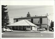
Constructed from 1981
The Esperance Civic Centre is an important building in the life of the local community. It is used as an entertainment centre, and provides a venue for large group functions.
Situated to the west of the Shire Offices, and flanked by landscaped native gardens, the Esperance Civic Centre is a face brick building topped by a prominant metal, flat topped roof structure. A curved roadway provides vehicle access to the front door of the building.
Integrity: All
Very Good
| Name | Type | Year From | Year To |
|---|---|---|---|
| Tsigulis & Zuvela Pty Ltd | Architect | 1981 | - |
| Owner | Category |
|---|---|
| Shire of Esperance | Local Gov't |
This information is provided voluntarily as a public service. The information provided is made available in good faith and is derived from sources believed to be reliable and accurate. However, the information is provided solely on the basis that readers will be responsible for making their own assessment of the matters discussed herein and are advised to verify all relevant representations, statements and information.
Cnr Dempster & James Sts Esperance
(Moved here in 1970 from a location further south).
Esperance
Goldfields
Constructed from 1924
| Type | Status | Date | Documents |
|---|---|---|---|
| (no listings) |
| Type | Status | Date | Documents |
|---|---|---|---|
| (no listings) |
| Type | Status | Date | Grading/Management | |
|---|---|---|---|---|
| Category | ||||
| Municipal Inventory | Adopted | 23 Jul 1996 | ||
| Local Heritage Survey | Adopted | 27 Apr 2021 | Considerable significance | |
| Statewide War Memorial Survey | Completed | 01 May 1996 | ||
| Name | Type | Year From | Year To |
|---|---|---|---|
| W H G Hearn (Gunner) | Architect | - | - |
Historic site
| Epoch | General | Specific |
|---|---|---|
| Present Use | MONUMENT\CEMETERY | Monument |
| Original Use | MONUMENT\CEMETERY | Monument |
| Type | General | Specific |
|---|---|---|
| Other | STONE | Marble |
| Other | STONE | Other Stone |
| General | Specific |
|---|---|
| OUTSIDE INFLUENCES | World Wars & other wars |
This information is provided voluntarily as a public service. The information provided is made available in good faith and is derived from sources believed to be reliable and accurate. However, the information is provided solely on the basis that readers will be responsible for making their own assessment of the matters discussed herein and are advised to verify all relevant representations, statements and information.
Constructed from 1924
This obelisk has an artificial moulded flag on top which is painted in the Australian colours. It commemorates the soldiers who died in the World Wars. The slabs for the memorial were precast in Perth, and once in place the core was filled with rubble.
The tender for building this memorial was closely contested by Mr Boswell Synno!, Mr Stearne (Senior) and the successful tenderer. 'Gunner' Hearn. Mr Hearn was the plumber and undertaker in Esperance. The memorial is a tribute to those who died in the World Wars.
Integrity: All Modifications: Cement slabs, precast in Perth, core filled with rubble.
| Name | Type | Year From | Year To |
|---|---|---|---|
| WHG Hearn | Architect | 1924 | - |
| Owner | Category |
|---|---|
| Crown Land | State Gov't |
This information is provided voluntarily as a public service. The information provided is made available in good faith and is derived from sources believed to be reliable and accurate. However, the information is provided solely on the basis that readers will be responsible for making their own assessment of the matters discussed herein and are advised to verify all relevant representations, statements and information.