Local Government
Esperance
Region
Goldfields
84 Dempster St Esperance
This entry P00825 includes only the RSL Building/School (fmr) and is part of P18402 Esperance RSL Building, Norfolk Island Pines and War Memorial. P18402 was created to incorporate the additional elements.
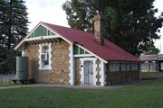
Esperance School
Original School, Road Board, Public Library
Esperance
Goldfields
Constructed from 1895
| Type | Status | Date | Documents |
|---|---|---|---|
| (no listings) |
| Type | Status | Date | Documents |
|---|---|---|---|
| (no listings) |
| Type | Status | Date | Grading/Management | |
|---|---|---|---|---|
| Category | ||||
| Local Heritage Survey | Adopted | 27 Apr 2021 | Exceptional significance | |
| Municipal Inventory | Adopted | 23 Jul 1996 | ||
| Register of the National Estate | Indicative Place | |||
| Classified by the National Trust | Recorded | 11 Jun 1973 | ||
18402 Esperance RSL Building, Norfolk Island Pine Trees and War Memorial
| Name | Type | Year From | Year To |
|---|---|---|---|
| J.D. Francis | Architect | - | - |
| Library Id | Title | Medium | Year Of Publication |
|---|---|---|---|
| 11358 | Cast iron pillar boxes of Western Australia: An early history of the J & E Ledger foundry | Book | 2015 |
Individual Building or Group
| Epoch | General | Specific |
|---|---|---|
| Present Use | SOCIAL\RECREATIONAL | RSL Hall |
| Other Use | EDUCATIONAL | Library |
| Original Use | EDUCATIONAL | Combined School |
| Style |
|---|
| Federation Arts and Crafts |
| Type | General | Specific |
|---|---|---|
| Roof | METAL | Corrugated Iron |
| Wall | STONE | Granite |
| General | Specific |
|---|---|
| SOCIAL & CIVIC ACTIVITIES | Education & science |
This information is provided voluntarily as a public service. The information provided is made available in good faith and is derived from sources believed to be reliable and accurate. However, the information is provided solely on the basis that readers will be responsible for making their own assessment of the matters discussed herein and are advised to verify all relevant representations, statements and information.
Constructed from 1896
This building is of significant heritage value due to its exellent condition with very little alteration. It is a very fine example of the architectural style for country towns. It is one of few municipal or government buildings relating to the architect/influence of George Temple Poole. It also shows the use of local building material. It has been listed by the National Trust
This small compact stone building is set in a landscaped area of pines. Built in the style of George Temple Poole buildings with decorative gables. it bas one main room and two small rooms. The four panel doors are of heavy timbers. panelled with timber used diagonally. The windows are high and are original. There is smooth painted decorative quoining on the corners and around the window frames, providing a contrast with dark stone walls.
Integrity: All. Some decorative wood strips missing. Modifications: None outside, little inside- roof painted red.
Very Good
| Name | Type | Year From | Year To |
|---|---|---|---|
| JD Francis | Architect | 1896 | - |
| Ref ID No | Ref Name | Ref Source | Ref Date |
|---|---|---|---|
| Road Board personnel | Espernnce Museum | 1904 | |
| "Letter tot he Secretary of Education". | Espernnce Museum | 1895 | |
| Photos I | 1995 |
| Owner | Category |
|---|---|
| Returned and Services league of Australia | Inc. Non-profit body |
This information is provided voluntarily as a public service. The information provided is made available in good faith and is derived from sources believed to be reliable and accurate. However, the information is provided solely on the basis that readers will be responsible for making their own assessment of the matters discussed herein and are advised to verify all relevant representations, statements and information.
68 Dempster Street Esperance
Esperance
Goldfields
| Type | Status | Date | Documents |
|---|---|---|---|
| (no listings) |
| Type | Status | Date | Documents |
|---|---|---|---|
| RHP - Does not warrant assessment | Current | 13 Nov 2020 |
| Type | Status | Date | Grading/Management | |
|---|---|---|---|---|
| Category | ||||
| (no listings) | ||||
The place includes the former Customs & Goods Shed (now the Esperance Museum), the Railway Ladies Waiting Room (1926), the Railway Booking Office (1927) and the surrounding parkland reserve.
Precinct or Streetscape
| Epoch | General | Specific |
|---|---|---|
| Original Use | GOVERNMENTAL | Customs House\Bond Store |
This information is provided voluntarily as a public service. The information provided is made available in good faith and is derived from sources believed to be reliable and accurate. However, the information is provided solely on the basis that readers will be responsible for making their own assessment of the matters discussed herein and are advised to verify all relevant representations, statements and information.
Esperance Harbour Esperance
Esperance
Goldfields
Constructed from 1897
| Type | Status | Date | Documents |
|---|---|---|---|
| (no listings) |
| Type | Status | Date | Documents |
|---|---|---|---|
| (no listings) |
| Type | Status | Date | Grading/Management | |
|---|---|---|---|---|
| Category | ||||
| Local Heritage Survey | Adopted | 27 Apr 2021 | Some/Moderate significance | |
| Municipal Inventory | Adopted | 23 Jul 1996 | ||
Other Built Type
| Epoch | General | Specific |
|---|---|---|
| Present Use | Transport\Communications | Water: Dock\Wharf Bldg or Structure |
| Original Use | Transport\Communications | Water: Other |
| Type | General | Specific |
|---|---|---|
| Other | STONE | Granite |
| General | Specific |
|---|---|
| DEMOGRAPHIC SETTLEMENT & MOBILITY | Exploration & surveying |
This information is provided voluntarily as a public service. The information provided is made available in good faith and is derived from sources believed to be reliable and accurate. However, the information is provided solely on the basis that readers will be responsible for making their own assessment of the matters discussed herein and are advised to verify all relevant representations, statements and information.
This place has historic and scientific value as the first established benchmark in the area. It is the datum for the original Admiralty charts, established either by Flinders (1802) or Combe (in Waterwitch) 1897 or others between (needs further research).
The bench mark is now situated approximately two metres below ground level (the area has been filled). A large iron tube gives access to the bench mark.
Integrity: All
Difficult to know
This information is provided voluntarily as a public service. The information provided is made available in good faith and is derived from sources believed to be reliable and accurate. However, the information is provided solely on the basis that readers will be responsible for making their own assessment of the matters discussed herein and are advised to verify all relevant representations, statements and information.
Fisheries Rd Esperance
Esperance
Goldfields
| Type | Status | Date | Documents |
|---|---|---|---|
| (no listings) |
| Type | Status | Date | Documents |
|---|---|---|---|
| (no listings) |
| Type | Status | Date | Grading/Management | |
|---|---|---|---|---|
| Category | ||||
| Register of the National Estate | Registered | 21 Mar 1978 | ||
Landscape
| Epoch | General | Specific |
|---|---|---|
| Original Use | PARK\RESERVE | Park\Reserve |
This information is provided voluntarily as a public service. The information provided is made available in good faith and is derived from sources believed to be reliable and accurate. However, the information is provided solely on the basis that readers will be responsible for making their own assessment of the matters discussed herein and are advised to verify all relevant representations, statements and information.
Forrest St Esperance
Esperance
Goldfields
Constructed from 1910
| Type | Status | Date | Documents |
|---|---|---|---|
| (no listings) |
| Type | Status | Date | Documents |
|---|---|---|---|
| (no listings) |
| Type | Status | Date | Grading/Management | |
|---|---|---|---|---|
| Category | ||||
| Fire & Rescue Service Heritage Inventory | Adopted | 30 Aug 1997 | ||
Historic Site
| Epoch | General | Specific |
|---|---|---|
| Present Use | VACANT\UNUSED | Vacant\Unused |
| Original Use | GOVERNMENTAL | Fire Station |
| General | Specific |
|---|---|
| OCCUPATIONS | Commercial & service industries |
| SOCIAL & CIVIC ACTIVITIES | Community services & utilities |
This information is provided voluntarily as a public service. The information provided is made available in good faith and is derived from sources believed to be reliable and accurate. However, the information is provided solely on the basis that readers will be responsible for making their own assessment of the matters discussed herein and are advised to verify all relevant representations, statements and information.
Lot 1 Forrest St Esperance
Esperance
Goldfields
Constructed from 1969
| Type | Status | Date | Documents |
|---|---|---|---|
| (no listings) |
| Type | Status | Date | Documents |
|---|---|---|---|
| RHP - Does not warrant assessment | Current | 30 Sep 2011 |
| Type | Status | Date | Grading/Management | |
|---|---|---|---|---|
| Category | ||||
| Fire & Rescue Service Heritage Inventory | Adopted | 30 Aug 1997 | ||
Individual Building or Group
| Epoch | General | Specific |
|---|---|---|
| Original Use | GOVERNMENTAL | Fire Station |
| Present Use | GOVERNMENTAL | Fire Station |
| Style |
|---|
| Vernacular |
| Type | General | Specific |
|---|---|---|
| Roof | METAL | Steel |
| Wall | BRICK | Common Brick |
| General | Specific |
|---|---|
| OCCUPATIONS | Commercial & service industries |
| SOCIAL & CIVIC ACTIVITIES | Community services & utilities |
This information is provided voluntarily as a public service. The information provided is made available in good faith and is derived from sources believed to be reliable and accurate. However, the information is provided solely on the basis that readers will be responsible for making their own assessment of the matters discussed herein and are advised to verify all relevant representations, statements and information.
18 Hicks St Esperance
Esperance
Goldfields
Constructed from 1979
| Type | Status | Date | Documents |
|---|---|---|---|
| (no listings) |
| Type | Status | Date | Documents |
|---|---|---|---|
| (no listings) |
| Type | Status | Date | Grading/Management | |
|---|---|---|---|---|
| Category | ||||
| Uniting Church Inventory | Completed | 01 Oct 1996 | ||
Individual Building or Group
| Epoch | General | Specific |
|---|---|---|
| Present Use | RELIGIOUS | Housing or Quarters |
| Original Use | RELIGIOUS | Housing or Quarters |
| Type | General | Specific |
|---|---|---|
| Roof | TILE | Other Tile |
| Wall | BRICK | Common Brick |
| General | Specific |
|---|---|
| SOCIAL & CIVIC ACTIVITIES | Religion |
This information is provided voluntarily as a public service. The information provided is made available in good faith and is derived from sources believed to be reliable and accurate. However, the information is provided solely on the basis that readers will be responsible for making their own assessment of the matters discussed herein and are advised to verify all relevant representations, statements and information.
Cnr James St & The Esplanade Esperance
Opposite the Esperance Museum in Esperance Bay
Esperance
Goldfields
Constructed from 1896
| Type | Status | Date | Documents |
|---|---|---|---|
| (no listings) |
| Type | Status | Date | Documents |
|---|---|---|---|
| (no listings) |
| Type | Status | Date | Grading/Management | |
|---|---|---|---|---|
| Category | ||||
| Statewide Lge Timber Str Survey | Completed | 11 Dec 1998 | ||
| Library Id | Title | Medium | Year Of Publication |
|---|---|---|---|
| 9772 | Museum Park period village Esperance, WA. Heritage Walk Trail. | Brochure | 207 |
Historic site
| Epoch | General | Specific |
|---|---|---|
| Present Use | Transport\Communications | Water: Jetty |
| Original Use | Transport\Communications | Water: Jetty |
| General | Specific |
|---|---|
| TRANSPORT & COMMUNICATIONS | River & sea transport |
This information is provided voluntarily as a public service. The information provided is made available in good faith and is derived from sources believed to be reliable and accurate. However, the information is provided solely on the basis that readers will be responsible for making their own assessment of the matters discussed herein and are advised to verify all relevant representations, statements and information.
Cnr Jane & Black St Esperance
(In Esperance Pre-Primary Grounds)
Esperance
Goldfields
Constructed from 1897
| Type | Status | Date | Documents |
|---|---|---|---|
| (no listings) |
| Type | Status | Date | Documents |
|---|---|---|---|
| (no listings) |
| Type | Status | Date | Grading/Management | |
|---|---|---|---|---|
| Category | ||||
| Municipal Inventory | Adopted | 23 Jul 1996 | ||
| Local Heritage Survey | Adopted | 27 Apr 2021 | Some/Moderate significance | |
Historic Site
| Epoch | General | Specific |
|---|---|---|
| Original Use | Transport\Communications | Water: Other |
| Present Use | Transport\Communications | Water: Other |
| General | Specific |
|---|---|
| DEMOGRAPHIC SETTLEMENT & MOBILITY | Exploration & surveying |
This information is provided voluntarily as a public service. The information provided is made available in good faith and is derived from sources believed to be reliable and accurate. However, the information is provided solely on the basis that readers will be responsible for making their own assessment of the matters discussed herein and are advised to verify all relevant representations, statements and information.
Constructed from 1897
This place has historic and scientific value. The obelisk was established by Commander Combe of the survey ship "Waterwitch" in 1897.
The survey obelisk with writing cut into the cut stone or concrete is dated 1897. It is set into the lawn of the pre-primary playground.
Integrity: All
Very Good
| Name | Type | Year From | Year To |
|---|---|---|---|
| Crew of Waterwitch | Architect | - | - |
| JWCombe RN (commander of Waterwitch) | Architect | - | - |
| Ref ID No | Ref Name | Ref Source | Ref Date |
|---|---|---|---|
| Graham Gath; "Admiralty Charts". |
| Owner | Category |
|---|---|
| Shire of Esperance | Local Gov't |
This information is provided voluntarily as a public service. The information provided is made available in good faith and is derived from sources believed to be reliable and accurate. However, the information is provided solely on the basis that readers will be responsible for making their own assessment of the matters discussed herein and are advised to verify all relevant representations, statements and information.
Loc 4 Mardabilla Esperance
includes John Paul Brooks' Grave
Balbinia Station
Balbinya Rock
Ray's Rock
Esperance
Goldfields
Constructed from 1883
| Type | Status | Date | Documents |
|---|---|---|---|
| (no listings) |
| Type | Status | Date | Documents |
|---|---|---|---|
| (no listings) |
| Type | Status | Date | Grading/Management | |
|---|---|---|---|---|
| Category | ||||
| Register of the National Estate | Indicative Place | |||
| Municipal Inventory | Adopted | 27 Mar 1997 | ||
| Local Heritage Survey | Adopted | 27 Apr 2021 | Some/Moderate significance | |
| Name | Type | Year From | Year To |
|---|---|---|---|
| Fred Stein & J P Brooks | Architect | - | - |
Historic Site
| Epoch | General | Specific |
|---|---|---|
| Original Use | FARMING\PASTORAL | Other |
| Present Use | VACANT\UNUSED | Vacant\Unused |
| Type | General | Specific |
|---|---|---|
| Wall | STONE | Limestone |
| Roof | METAL | Corrugated Iron |
| General | Specific |
|---|---|
| DEMOGRAPHIC SETTLEMENT & MOBILITY | Settlements |
This information is provided voluntarily as a public service. The information provided is made available in good faith and is derived from sources believed to be reliable and accurate. However, the information is provided solely on the basis that readers will be responsible for making their own assessment of the matters discussed herein and are advised to verify all relevant representations, statements and information.
Constructed from 1883
The place has historical significance for it's association with Alexander Forrest. The place has scientific significance for it's association with John Paul Brooks who established the station due to his exploration of the area and the scientific paper he published.
Balbinya is the name given to the area where can be found two buildings (storeshed and cottage) on 160 acres of surveyed freehold land. Cleared of trees and bush, there is a large granite rock catchment with two main dams and many smaller dams, dry stone fencing, remains of a boundary fence, an orchard with two mulberry trees. a fig tree, a rose bush, two historic graves (one marked) and many other features, including a cairn built by Alexander Forrest on an exploration trip, 10 October 1871. In all it is a beautiful place in a picturesque setting.
The area was first noted by Alexander Forrest in October 1871. The station was established by John Paul Brooks in 1883 and was run by him until his death in 1930. He published scientific papers of the area and did a lot of exploration with the Ponton Brothers and Sharpe of Pt Malcolm (Balladonia) in Ute 1870s. He was also the first linesman on the Israelite Telegraph Station. His sister, Sarah Theresa Brooks, painted pictures of Ute Israelite area and was an accomplished artist. The Dimer family of Israelite and Nanambinia ran the station as an outcamp until the late 1940s.
Integrity: The storeshed is original , the cottage rebuilt from a pile of stones Modifications: Roof removed March 1937, replaced 1991-4
Good
| Name | Type | Year From | Year To |
|---|---|---|---|
| Fred Stein & J P Brooks | Architect | 1883 | - |
| Ref ID No | Ref Name | Ref Source | Ref Date |
|---|---|---|---|
| Photos; "Esperance Express". | Esperance Museum. | 1 March 1989 | |
| D Voight; "Collection". | 1986 | ||
| A E Crocker. K Dimer. J Crocker; "Diaries and records of Nanambini a & Balladonia Station" |
| Owner | Category |
|---|---|
| VCL | State Gov't |
This information is provided voluntarily as a public service. The information provided is made available in good faith and is derived from sources believed to be reliable and accurate. However, the information is provided solely on the basis that readers will be responsible for making their own assessment of the matters discussed herein and are advised to verify all relevant representations, statements and information.
Mardabilla 10k NNE of Balbinya Stn Esperance
Includes Main dam, secondary dam and blind for shooting game & store stack
Esperance
Goldfields
Constructed from 1880
| Type | Status | Date | Documents |
|---|---|---|---|
| (no listings) |
| Type | Status | Date | Documents |
|---|---|---|---|
| (no listings) |
| Type | Status | Date | Grading/Management | |
|---|---|---|---|---|
| Category | ||||
| Municipal Inventory | Adopted | 23 Jul 1996 | ||
| Local Heritage Survey | Adopted | 27 Apr 2021 | Some/Moderate significance | |
Historic site
| Epoch | General | Specific |
|---|---|---|
| Present Use | VACANT\UNUSED | Vacant\Unused |
| Original Use | GOVERNMENTAL | Reservoir or Dam |
| Original Use | FARMING\PASTORAL | Other |
| Type | General | Specific |
|---|---|---|
| Wall | EARTH | Other Earth |
| General | Specific |
|---|---|
| TRANSPORT & COMMUNICATIONS | Droving |
This information is provided voluntarily as a public service. The information provided is made available in good faith and is derived from sources believed to be reliable and accurate. However, the information is provided solely on the basis that readers will be responsible for making their own assessment of the matters discussed herein and are advised to verify all relevant representations, statements and information.
Constructed from 1880
This was the main watering hole to the north of Balbinya station. and it would have been essential to the survival of the station Generally this is a place that remains as it would have been used. a good example of bush craftmanship and ingenuity.
There is a large granite rock used as a catchment for one main dam and several smaller dams. There are some dry stone blinds for shooting animals for meat. The purpose of another small complete construction of dry stone is unknown. No c1caring has been done so the area is still natural bushland.
Integrity: All the original fabric is intact Modifications: None
Good
| Ref ID No | Ref Name | Ref Source | Ref Date |
|---|---|---|---|
| K Kimer; "Diaries of Nanambinia Station". |
| Owner | Category |
|---|---|
| Department of Land and Surveys | State Gov't |
This information is provided voluntarily as a public service. The information provided is made available in good faith and is derived from sources believed to be reliable and accurate. However, the information is provided solely on the basis that readers will be responsible for making their own assessment of the matters discussed herein and are advised to verify all relevant representations, statements and information.
Cnr Merivale & Jim's Oven Rd Esperance
Boyatup Farm
Dunns' Farm, Dunns' Station
Esperance
Goldfields
Constructed from 1895
| Type | Status | Date | Documents |
|---|---|---|---|
| (no listings) |
| Type | Status | Date | Documents |
|---|---|---|---|
| (no listings) |
| Type | Status | Date | Grading/Management | |
|---|---|---|---|---|
| Category | ||||
| Municipal Inventory | Adopted | 23 Jul 1996 | ||
| Local Heritage Survey | Adopted | 27 Apr 2021 | Some/Moderate significance | |
Individual Building or Group
| Epoch | General | Specific |
|---|---|---|
| Present Use | FARMING\PASTORAL | Homestead |
| Original Use | FARMING\PASTORAL | Homestead |
| Type | General | Specific |
|---|---|---|
| Wall | METAL | Corrugated Iron |
| Roof | METAL | Corrugated Iron |
| General | Specific |
|---|---|
| OCCUPATIONS | Grazing, pastoralism & dairying |
This information is provided voluntarily as a public service. The information provided is made available in good faith and is derived from sources believed to be reliable and accurate. However, the information is provided solely on the basis that readers will be responsible for making their own assessment of the matters discussed herein and are advised to verify all relevant representations, statements and information.
Constructed from 1895
Nothing remains of the original house or fann buildings as they were replaced by Harry Dunn in the 1950s. A portion of the stone and cement fireplace of their replacement dwelling remained in 1993. The orchard was neglected and only a few dead fruit trees mark its location. Evidence of occupancy by the pioneer DlInn family is the well maintained grave of Henry Hatton. who die on 22.5.1924 aged 62 years. He was the brother of Mrs Mary Ann Dunn (1860-1944) and for many years he helped Andrew and Mary Dunn on their isolated fann. This grave and the yate swamp from which the family obtained water, firewood. and building scantling are the remaining link with the early settlers of the property, which is now owned by a larger pastoral and farming enterprise.
In 1882 Andrew Dunn drove 1000 sheep from York to Thomas River for Campbell Taylor. Returning to Albany he married Mary Ann Hatton in 1883. They moved to Balladonia and worked for Ponton and Sharpe in 1884. In 1885 they moved to Thomas River and he worked for Campbell Taylor as overseer. He managed the station until 1895. He selected a block at Boyatup in 1886 and moved there in 1895 and built the first stages of the house. There are anecdotal accounts of extensions to the house as the family grew to 14 children (only 13 survived). They grew vegetables, fruit and hay crops and sold grapes, onions, hay to F J Daw of Esperance. They ran cattle and sheep on leasehold and crown land. The farm was self sufficient. Proceeds from the above sales plus sale of wool. hides. dingo scalps and kangaroo skins were the main source of income. This is a good example of subsistence farming in the period 1880-1940. In its day Boyatup was a place where travellers to Israelite Bay. Pt Malcolm. Thomas River and Duke of Orleans were assured of hospitality and 'a bed for the night'. Overland telegraph linesmen were regular callers. This is an example of small scale farming in the region until modern soil technology enabled large scale less diverse operations to replace it.
Site Only
| Name | Type | Year From | Year To |
|---|---|---|---|
| Andrew Dunn | Architect | 1895 | - |
| Owner | Category |
|---|---|
| Warren | Other Private |
This information is provided voluntarily as a public service. The information provided is made available in good faith and is derived from sources believed to be reliable and accurate. However, the information is provided solely on the basis that readers will be responsible for making their own assessment of the matters discussed herein and are advised to verify all relevant representations, statements and information.
Mt Ragged Rd Esperance
Mud map of known places
Esperance
Goldfields
| Type | Status | Date | Documents |
|---|---|---|---|
| (no listings) |
| Type | Status | Date | Documents |
|---|---|---|---|
| (no listings) |
| Type | Status | Date | Grading/Management | |
|---|---|---|---|---|
| Category | ||||
| Local Heritage Survey | Adopted | 27 Apr 2021 | Some/Moderate significance | |
| Municipal Inventory | Adopted | 23 Jul 1996 | ||
Historic Site
| Epoch | General | Specific |
|---|---|---|
| Original Use | Transport\Communications | Road: Other |
| Present Use | Transport\Communications | Road: Other |
| General | Specific |
|---|---|
| DEMOGRAPHIC SETTLEMENT & MOBILITY | Settlements |
This information is provided voluntarily as a public service. The information provided is made available in good faith and is derived from sources believed to be reliable and accurate. However, the information is provided solely on the basis that readers will be responsible for making their own assessment of the matters discussed herein and are advised to verify all relevant representations, statements and information.
These watering places have social heritage. They were important in the patterns of early settlement by the white pioneers in the district. They adopted Aboriginal names for the watering places. This information came from the Dimer family. Heinrich Dimer, with a crew mate, jumped ship from the barque "Platina" in Princess Royal Harbour, Albany in June 1884. They were found walking along the beach 10 miles east of Albany by Campbell Taylor who hid them on Bald Island. Dimer worked for Taylor at 'Candynp' (Albany) and 'Lynburn' (Thomas River) before taking up his own property 'Nanambinia' north of Israelite Bay. Heinrich (Henry) Dimer married Topsy Whitehead in May 1899.
Aboriginal names were given 10 a number of walering places on MI Ragged Road. These were given 10 Pal Daniel (1960s) by Barney Dimer. The Dimer family was associaled with the Brooks family.
| Reserve | Lot/Location | Plan/Diagram | Vol/Folio |
|---|---|---|---|
| 24047 | 1019/878 |
This information is provided voluntarily as a public service. The information provided is made available in good faith and is derived from sources believed to be reliable and accurate. However, the information is provided solely on the basis that readers will be responsible for making their own assessment of the matters discussed herein and are advised to verify all relevant representations, statements and information.
Parmango Rd Esperance
Esperance
Goldfields
Constructed from 1890
| Type | Status | Date | Documents |
|---|---|---|---|
| (no listings) |
| Type | Status | Date | Documents |
|---|---|---|---|
| (no listings) |
| Type | Status | Date | Grading/Management | |
|---|---|---|---|---|
| Category | ||||
| Local Heritage Survey | Adopted | 27 Apr 2021 | Some/Moderate significance | |
| Municipal Inventory | Adopted | 23 Jul 1996 | ||
Individual Building or Group
| Epoch | General | Specific |
|---|---|---|
| Original Use | FARMING\PASTORAL | Other |
| Present Use | OTHER | Other |
| Type | General | Specific |
|---|---|---|
| Wall | STONE | Granite |
| General | Specific |
|---|---|
| OCCUPATIONS | Grazing, pastoralism & dairying |
| DEMOGRAPHIC SETTLEMENT & MOBILITY | Settlements |
This information is provided voluntarily as a public service. The information provided is made available in good faith and is derived from sources believed to be reliable and accurate. However, the information is provided solely on the basis that readers will be responsible for making their own assessment of the matters discussed herein and are advised to verify all relevant representations, statements and information.
Constructed from 1890
On Deralinya Station are a three roomed house with large fireplace and verandahs and a large storeshed. The land has been cleared parkland fashion. There are two dams with a granite rock catchment. The buildings are on high ground overlooking the dams and catchment. The main road runs past the property.
The well constructed buildings of local materials were built by a well known character of the area. George Burns Scott was a pioneer with a dam sinking plant who liked building and establishing stations and then moving on. The painter, A E Baesjou. lived there for some years as a little girl. The property was used as an outstation to Balladonia until 1936 when the roofs were removed. The last load of wool was taken out in 1920. Cattle were run there until 1936. It is a beautiful place on a main road.
Integrity: The walls are very sound. everything else has been removed. Modifications: Roof removed 1936, started being replaced 1992.
Fair
| Ref ID No | Ref Name | Ref Source | Ref Date |
|---|---|---|---|
| A E Bacsiau and K Kirner. J Crocker; "Diaries of Balladonia Station and Nanambinia Station.". |
| Owner | Category |
|---|---|
| CALM | State Gov't |
This information is provided voluntarily as a public service. The information provided is made available in good faith and is derived from sources believed to be reliable and accurate. However, the information is provided solely on the basis that readers will be responsible for making their own assessment of the matters discussed herein and are advised to verify all relevant representations, statements and information.
95 Parmango Rd Esperance
Bououborinia Dam
Esperance
Goldfields
Constructed from 1885
| Type | Status | Date | Documents |
|---|---|---|---|
| (no listings) |
| Type | Status | Date | Documents |
|---|---|---|---|
| (no listings) |
| Type | Status | Date | Grading/Management | |
|---|---|---|---|---|
| Category | ||||
| Local Heritage Survey | Adopted | 27 Apr 2021 | Some/Moderate significance | |
| Municipal Inventory | Adopted | 27 Mar 1997 | ||
| Name | Type | Year From | Year To |
|---|---|---|---|
| H Dimer | Architect | - | - |
Historic site
| Epoch | General | Specific |
|---|---|---|
| Original Use | FARMING\PASTORAL | Other |
| Present Use | FARMING\PASTORAL | Other |
| Original Use | GOVERNMENTAL | Reservoir or Dam |
| General | Specific |
|---|---|
| OCCUPATIONS | Grazing, pastoralism & dairying |
This information is provided voluntarily as a public service. The information provided is made available in good faith and is derived from sources believed to be reliable and accurate. However, the information is provided solely on the basis that readers will be responsible for making their own assessment of the matters discussed herein and are advised to verify all relevant representations, statements and information.
Constructed from 1885
On this area of land are a large granite rock of Aboriginal significance, one main dam. one smaller dam, and two fenced paddocks, used for growing hay from 1927 to 1944. Many old roads lead to and from the rock to other dams in the area. It is situated on Parmango Road. There are no fruit trees left alive in the orchard. The netting is intact but overgrown.
The dam was originally sunk to water sheep being shepherded in the area. The paddock was fenced in 1927 with rabbit proof netting. The horses that were originally put there in the 1890s to breed, were used until 1949 by the Dimer family. There are still horses to be found there today.
Integrity: The water holes are in good original condition. The fenced paddock is in bad shape but materials are still there.
Poor
| Name | Type | Year From | Year To |
|---|---|---|---|
| H Dimer | Architect | 1885 | - |
| Ref ID No | Ref Name | Ref Source | Ref Date |
|---|---|---|---|
| "Diaries of Nanambinva & Balladonia Station and decendents." |
| Owner | Category |
|---|---|
| VCL | State Gov't |
This information is provided voluntarily as a public service. The information provided is made available in good faith and is derived from sources believed to be reliable and accurate. However, the information is provided solely on the basis that readers will be responsible for making their own assessment of the matters discussed herein and are advised to verify all relevant representations, statements and information.
Pink Lake Dr Esperance
Esperance
Goldfields
Constructed from 1930
| Type | Status | Date | Documents |
|---|---|---|---|
| (no listings) |
| Type | Status | Date | Documents |
|---|---|---|---|
| (no listings) |
| Type | Status | Date | Grading/Management | |
|---|---|---|---|---|
| Category | ||||
| Municipal Inventory | Adopted | 23 Jul 1996 | ||
Individual Building or Group
| Epoch | General | Specific |
|---|---|---|
| Original Use | COMMERCIAL | Warehouse |
| Present Use | COMMERCIAL | Warehouse |
| General | Specific |
|---|---|
| OCCUPATIONS | Mining {incl. mineral processing} |
This information is provided voluntarily as a public service. The information provided is made available in good faith and is derived from sources believed to be reliable and accurate. However, the information is provided solely on the basis that readers will be responsible for making their own assessment of the matters discussed herein and are advised to verify all relevant representations, statements and information.
Constructed from 1930
E J McCarthy took a lease on Spencer Lake, called Pink Lake. He first used a building in the townsite (behind James Wharton White's residence) for the salt works. A shed was built at the lake in 1900. All works were moved there. The salt was sold in pink packets - I pound with Pink Lake Sait, E J McCarthy on the labels. Working there were Angus McLennan, Edward James McCarthy (Junior) and Moses, an Aborigine.
| Owner | Category |
|---|---|
| Lease of Land to Cheetham Salt Ltd | Other Private |
This information is provided voluntarily as a public service. The information provided is made available in good faith and is derived from sources believed to be reliable and accurate. However, the information is provided solely on the basis that readers will be responsible for making their own assessment of the matters discussed herein and are advised to verify all relevant representations, statements and information.
Pink Lake Rd Esperance
Esperance
Goldfields
Constructed from 1897
| Type | Status | Date | Documents |
|---|---|---|---|
| (no listings) |
| Type | Status | Date | Documents |
|---|---|---|---|
| (no listings) |
| Type | Status | Date | Grading/Management | |
|---|---|---|---|---|
| Category | ||||
| Municipal Inventory | Adopted | 23 Jul 1996 | ||
| Local Heritage Survey | Adopted | 27 Apr 2021 | Considerable significance | |
Other Built Type
| Epoch | General | Specific |
|---|---|---|
| Present Use | MONUMENT\CEMETERY | Cemetery |
| Original Use | MONUMENT\CEMETERY | Cemetery |
| General | Specific |
|---|---|
| PEOPLE | Early settlers |
This information is provided voluntarily as a public service. The information provided is made available in good faith and is derived from sources believed to be reliable and accurate. However, the information is provided solely on the basis that readers will be responsible for making their own assessment of the matters discussed herein and are advised to verify all relevant representations, statements and information.
Constructed from 1897
This area o fland was considered out-of-town in 1897. It was set aside as a cemetery and 14 graves which had been removed from the first cemetery were replaced in this cemetery. An avenue of trees was planted and these line a wide pathway.
This land was set aside as a cemetery after the land for the original cemetery was considered necessary for the expansion of the town facilities. The cricket club was given the land and 14 of the graves were moved to the Pink Lake Road site. The cemetery contains significant historical record of early pioneers in the Esperance district.
| Owner | Category |
|---|---|
| Shire of Esperance | Local Gov't |
This information is provided voluntarily as a public service. The information provided is made available in good faith and is derived from sources believed to be reliable and accurate. However, the information is provided solely on the basis that readers will be responsible for making their own assessment of the matters discussed herein and are advised to verify all relevant representations, statements and information.
Opp Quarry & Fisheries Rds intersection Esperance
Opposite Quarry Rd/Fisheries Rd intersection approx. 150m along boundary fence.
Esperance
Goldfields
Constructed from 1898
| Type | Status | Date | Documents |
|---|---|---|---|
| (no listings) |
| Type | Status | Date | Documents |
|---|---|---|---|
| (no listings) |
| Type | Status | Date | Grading/Management | |
|---|---|---|---|---|
| Category | ||||
| Municipal Inventory | Adopted | 23 Jul 1996 | ||
| Local Heritage Survey | Adopted | 27 Apr 2021 | Some/Moderate significance | |
Ellen Gude, Shire of Esperance, advised: "From the description it sounds a though only a portion of the wall of the cooks quarters remained when the MHI was done."
| Name | Type | Year From | Year To |
|---|---|---|---|
| James Dempster with stonemason. | Architect | - | - |
Individual Building or Group
| Epoch | General | Specific |
|---|---|---|
| Original Use | FARMING\PASTORAL | Other |
| Present Use | FARMING\PASTORAL | Other |
| General | Specific |
|---|---|
| OCCUPATIONS | Grazing, pastoralism & dairying |
This information is provided voluntarily as a public service. The information provided is made available in good faith and is derived from sources believed to be reliable and accurate. However, the information is provided solely on the basis that readers will be responsible for making their own assessment of the matters discussed herein and are advised to verify all relevant representations, statements and information.
Constructed from 1898
There were various parts to the complex: the cooks quarters, the shearing shed and the sheep dip. Of the limestone cooks quarters, only a portion of wall remains. There is evidence of a large cooking stove in the debris. The stone sheep dip has been filled in. but is probably sound.
From the 1876 to 1897 shearing took place at the Dempster woolshed on the Esplanade site. Later the surveying for developing the Esperance townsite necessitated moving the operation to another location at Wheatfield. Anecdotal accounts record that the shearers would be less influenced by liquor, which was by then readily available from hotels, and not controlled by the Dempsters. Shearing took place at Wheatfield from 1898 until the late 1920s.
Integrity: 10%
Very Poor
| Name | Type | Year From | Year To |
|---|---|---|---|
| James Dempster | Architect | 1898 | - |
| Ref ID No | Ref Name | Ref Source | Ref Date |
|---|---|---|---|
| R Erickson; "The Dempsters". |
| Owner | Category |
|---|---|
| H Lipfert - Sheep dip | Other Private |
| CALM - woolshed | State Gov't |
This information is provided voluntarily as a public service. The information provided is made available in good faith and is derived from sources believed to be reliable and accurate. However, the information is provided solely on the basis that readers will be responsible for making their own assessment of the matters discussed herein and are advised to verify all relevant representations, statements and information.
Recherche Archipelago Nature Reserve Esperance
9 k S of Cape Arid, 130 k E from Esperance 35 deg 06' S 123 deg 11' E
Isle De Milieu
Esperance
Goldfields
Constructed from 1830
| Type | Status | Date | Documents |
|---|---|---|---|
| (no listings) |
| Type | Status | Date | Documents |
|---|---|---|---|
| (no listings) |
| Type | Status | Date | Grading/Management | |
|---|---|---|---|---|
| Category | ||||
| Municipal Inventory | Adopted | 23 Jul 1996 | ||
| Local Heritage Survey | Adopted | 27 Apr 2021 | Some/Moderate significance | |
| Library Id | Title | Medium | Year Of Publication |
|---|---|---|---|
| 11794 | Beneath the colonial gaze: Modelling maritime society and cross-cultural contact on Australia's Southern Ocean frontier - the Archipelago of the Recherche, Western Australia | Heritage Study {Other} | 2016 |
Historic Site
| Epoch | General | Specific |
|---|---|---|
| Original Use | FARMING\PASTORAL | Other |
| Present Use | FARMING\PASTORAL | Other |
| Other Use | INDUSTRIAL\MANUFACTURING | Whalers or Sealers Oven |
| Type | General | Specific |
|---|---|---|
| Other | METAL | Corrugated Iron |
| General | Specific |
|---|---|
| OCCUPATIONS | Fishing & other maritime industry |
This information is provided voluntarily as a public service. The information provided is made available in good faith and is derived from sources believed to be reliable and accurate. However, the information is provided solely on the basis that readers will be responsible for making their own assessment of the matters discussed herein and are advised to verify all relevant representations, statements and information.
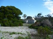
The well and fireplaces are examples of 1830s drystone work and arc all that remains of Anderson's sealing camp.
Middle Island is a large (1080 ha) picturesque island nine kilometres soulh of Cape Arid and 130 kilometres east from Esperance. It is a CALM nature reserve (Class A). From 1937 to 1958 a pastoral lease was held over the island by Alexander Chisholm of Kalgoorlie. The south coast has high cliffs while there is a long beach on the north coast. At the western end is Flinders Peak (174 metres). a large granite hill. Behind the beach is a pink saline lake approximately one kilometre across.
The notorious seal hunter (dubbed WA's only Pirate). John (Black Jack) Anderson and his crew worked from this island base. hunting seals in 1835 and 1836. Survivors from the shipwreck "Mountaineer" (1835) took refuge with the sealers for several months. The "Penguin". a Government steamer. was wrecked in 1920. The remains are close to the beach and easily accessible from Belinda Beach. which is named after the wreck of the sealer. "Belinda" (eI820).
Integrity: Well- all. Fireplaces- only part Modifications: Sheets of corrugated iron on top to protect.
Well- fair; Fireplaces- poor; Wreck - very poor.
| Ref ID No | Ref Name | Ref Source | Ref Date |
|---|---|---|---|
| "Court Declaration". | Albany Court |
| Owner | Category |
|---|---|
| CALM | State Gov't |
This information is provided voluntarily as a public service. The information provided is made available in good faith and is derived from sources believed to be reliable and accurate. However, the information is provided solely on the basis that readers will be responsible for making their own assessment of the matters discussed herein and are advised to verify all relevant representations, statements and information.
Stokes Nat Park, Fanny Bay Esperance
Moir's Fanny Cove Homestead
Esperance
Goldfields
Constructed from 1873 to 1880
| Type | Status | Date | Documents |
|---|---|---|---|
| State Register | Registered | 28 Aug 2001 | HCWebsite.Listing+ListingDocument, HCWebsite.Listing+ListingDocument |
| Type | Status | Date | Documents |
|---|---|---|---|
| (no listings) |
| Type | Status | Date | Grading/Management | |
|---|---|---|---|---|
| Category | ||||
| Classified by the National Trust | Classified | 06 Nov 1995 | ||
| Register of the National Estate | Identified Through State Process | |||
| Local Heritage Survey | Adopted | 27 Apr 2021 | Exceptional significance | |
| Municipal Inventory | Adopted | 23 Jul 1996 | ||
In State of ruin
| Library Id | Title | Medium | Year Of Publication |
|---|---|---|---|
| 5921 | Off-shears : the story of shearing sheds in Western Australia. | Book | 2002 |
| 4588 | Moir Homestead Conservation Plan. | Heritage Study {Cons'n Plan} | 2000 |
Individual Building or Group
| Epoch | General | Specific |
|---|---|---|
| Present Use | FARMING\PASTORAL | Homestead |
| Original Use | FARMING\PASTORAL | Homestead |
| Style |
|---|
| Victorian Georgian |
| Type | General | Specific |
|---|---|---|
| Other | STONE | Other Stone |
| General | Specific |
|---|---|
| OCCUPATIONS | Grazing, pastoralism & dairying |
| DEMOGRAPHIC SETTLEMENT & MOBILITY | Workers {incl. Aboriginal, convict} |
| DEMOGRAPHIC SETTLEMENT & MOBILITY | Aboriginal Occupation |
| DEMOGRAPHIC SETTLEMENT & MOBILITY | Resource exploitation & depletion |
| TRANSPORT & COMMUNICATIONS | Droving |
This information is provided voluntarily as a public service. The information provided is made available in good faith and is derived from sources believed to be reliable and accurate. However, the information is provided solely on the basis that readers will be responsible for making their own assessment of the matters discussed herein and are advised to verify all relevant representations, statements and information.
Constructed from 1888, Constructed from 1873
The Moir Fanny Cove Homestead and furm buildings were erected approximately two kilometres from Fanny Cove anchorage and about a half kilometre east of Fanny Cove. The limestone skeleton of the buildings, although in urgent need of stabilization, effectively reflect the atmosphere of such pioneer establishments. According to a National Trust report (1971) there were 5 structures: a house (similar in design to the old Dempster Homestead), woolshed, hut, forge and cast shed and remains of stock yards. Most roofs, floors, door and window frames had been removed. The kitchen range and adjacent bread oven, reflect the need for self sufficiency in the 'early days'. The smithy (forge) with its tool racks and outside wheel tyring slab was an important part of station activity. Despite poor condition the woolshed remains an interesting feature and the location of the horseworks and stockyards are clearly defined. There were remains of the wool press in the woolshed and remains of large bellows in the forge in 1971. At that time most of the buildings were occupied by bees, making detailed investigation difficult. The large 100 year old Moreton Bay fig tree and the tall palms growing up through it are impressive.
Nineteenth century pastoralists used the relatively small freehold homestead location as the hub of their extensive pastoral leases. Security of ownership of premises was assured and the sites selected were judged the best available. The Moirs of Fanny Cove cut the first track to Dundas in 1888 and later sold stores and equipment to miners landed from ships at Fanny Cove or trekking overland from Broomehill. It was also the base of their flour cartage contract to Coolgardie. The Fanny Cove Homestead saw the genesis of the branches of a family still making significant contributions to life in Esperance, Ravensthorpe and The Goldfields.
Integrity: Main building: walls, cottage walls, rafters, roof, drystone well- all excellent condition. Modifications: Original verandah removed from the homestead.
Homestead, Smithy Shed and Cottage- all quite sound
| Owner | Category |
|---|---|
| CALM | State Gov't |
This information is provided voluntarily as a public service. The information provided is made available in good faith and is derived from sources believed to be reliable and accurate. However, the information is provided solely on the basis that readers will be responsible for making their own assessment of the matters discussed herein and are advised to verify all relevant representations, statements and information.