Local Government
Gingin
Region
Avon Arc
Cowalla Rd Cowalla
Lot 465 on Plan 231047. Cowalla Road at Junction of Orange Spring Road. 48km NW of Gingin.
Whitfields
Gingin
Avon Arc
Constructed from 1851
| Type | Status | Date | Documents |
|---|---|---|---|
| Heritage List | Adopted | 17 Oct 2017 | |
| State Register | Registered | 26 May 2006 | HCWebsite.Listing+ListingDocument, HCWebsite.Listing+ListingDocument |
| Type | Status | Date | Documents |
|---|---|---|---|
| (no listings) |
| Type | Status | Date | Grading/Management | |
|---|---|---|---|---|
| Category | ||||
| Register of the National Estate | Permanent | 21 Mar 1978 | ||
| Classified by the National Trust | Classified | 11 Jun 1973 | ||
| Municipal Inventory | Adopted | 17 Oct 2017 | Category A | |
25092 North West Stock Route
Fair to good condition.
| Library Id | Title | Medium | Year Of Publication |
|---|---|---|---|
| 11916 | Cowalla and its buildings: the story of an early Moore River cattle station | Book | 2004 |
| 7943 | Cowalla Gingin. Conservation works final report. | Conservation works report | 2006 |
| 7121 | Images CD No. 33 : assessment images : Marribank/Carrolup, Cowalla Homestead Group, Barnes Theatre, Wagin Town Hall, Nungarin Roads Board, Connor's Mill. | C D Rom | 2004 |
| 6528 | Cowalla homestead : conservation management plan. | Heritage Study {Cons'n Plan} | 2003 |
| 9445 | Cowalla, Gingin. | Conservation works report | 2010 |
| 7220 | Cowalla and its buildings : the story of an early Moore River cattle station. | Book | 2004 |
Individual Building or Group
| Epoch | General | Specific |
|---|---|---|
| Original Use | FARMING\PASTORAL | Homestead |
| Present Use | FARMING\PASTORAL | Homestead |
| Style |
|---|
| Old Colonial Georgian |
| Type | General | Specific |
|---|---|---|
| Wall | EARTH | Adobe {Mud Brick} |
| Roof | METAL | Corrugated Iron |
| General | Specific |
|---|---|
| PEOPLE | Early settlers |
| TRANSPORT & COMMUNICATIONS | Mail services |
| DEMOGRAPHIC SETTLEMENT & MOBILITY | Workers {incl. Aboriginal, convict} |
| OCCUPATIONS | Grazing, pastoralism & dairying |
| TRANSPORT & COMMUNICATIONS | Droving |
| DEMOGRAPHIC SETTLEMENT & MOBILITY | Land allocation & subdivision |
This information is provided voluntarily as a public service. The information provided is made available in good faith and is derived from sources believed to be reliable and accurate. However, the information is provided solely on the basis that readers will be responsible for making their own assessment of the matters discussed herein and are advised to verify all relevant representations, statements and information.
Historic importance
Walls mud bat, floors pit sawn timber, roof now iron - originally thatch. House and 15 acres sold in 1858 to Robert de Burgh. 1903 present roof put on and jarrah matchboard ceilings run throughout. Additional rooms were added lengthwise. Old style kitchen separate from the ouse was built in 1862 - the coach house six years later. Since 1858 deBurghs have occupied the home. Now Max deBurgh and his wife live there, but W.J. deBurgh lived there till 1965. Mrs W.J. deBurgh is a descendant of Francis Whitfield (great granddaghter)
Assessment 1973 Construction 1852 (original 4 rooms) Builder: Francis Whitfield
This information is provided voluntarily as a public service. The information provided is made available in good faith and is derived from sources believed to be reliable and accurate. However, the information is provided solely on the basis that readers will be responsible for making their own assessment of the matters discussed herein and are advised to verify all relevant representations, statements and information.
Constructed from 1851
Cowalla Homestead Group is a rare intact collection of mid to late nineteenth century mud brick buildings. It was an important stopping place on the northern stock route in the nineteenth century, adjacent to a ford on the Moore River used by travellers on the route. It demonstrates the evolution of farming in the region from its initial opening up by European settlers in the 1850s to the present; and, was owned by prominent land owner Robert de Burgh who was Superintendent of the Convict Depot in Toodyay, Director of the Western Australian Bank, and employed 60 ticket of leave men from 1852 until 1873.
Located on the banks of the Moore River, the group comprises the homestead, kitchen and dairy and carriage house, and some distance toward the entry near the Cowalla Bridge, is a workers dwelling.
George and Edward Whitfield were granted 20,000 acres at Cowalla in 1850, building a 3-room mud brick house. In 1858 Robert de Burgh purchased the property and lived there. In 1863 he added to the house, and the detached kitchen and bakehouse was built. 1866, R de Burgh's son Walter took over, and after his death in 1873, his brother inlaw Henry Brockman leased the property until 1878 when Walter's brother Henry took over, In 1904, Henry's son RSM (Sid) took over, and after his death in 1946. His sons RH & JW de Burgh took over. When RH de Burgh died his son RMH (Max) inherited the property, on-selling to Joseph Matthews, a Texan, who owned it until 2002 when the de Burgh family acquired ownership again.
Integrity : High degree Authenticity : Moderate/High degree
Good
| Ref ID No | Ref Name | Ref Source | Ref Date |
|---|---|---|---|
| WJ de Burgh; "Cowall and it's buildings". | 2002 | ||
| WJ de Burgh; "The old north road". | Hesperian Press | 2002 | |
| WJ de Burgh; "Cowalla, Part 1, 2 & 3". | |||
| WJ & EM de Burgh; "The Breakaways". | St George Books | ||
| WJ de Burgh; "Neergabby". |
| Owner | Category |
|---|---|
| de Burgh Family | Other Private |
This information is provided voluntarily as a public service. The information provided is made available in good faith and is derived from sources believed to be reliable and accurate. However, the information is provided solely on the basis that readers will be responsible for making their own assessment of the matters discussed herein and are advised to verify all relevant representations, statements and information.
16 Brockman St Gingin
Cnr Brockman & Constable Streets
Gingin
Avon Arc
Constructed from 1886
| Type | Status | Date | Documents |
|---|---|---|---|
| Heritage List | Adopted | 17 Oct 2017 | |
| State Register | Registered | 27 Feb 1996 | HCWebsite.Listing+ListingDocument, HCWebsite.Listing+ListingDocument |
| Type | Status | Date | Documents |
|---|---|---|---|
| (no listings) |
| Type | Status | Date | Grading/Management | |
|---|---|---|---|---|
| Category | ||||
| Statewide Post Office Survey | Completed | 01 Mar 1992 | ||
| Classified by the National Trust | Recorded | 05 Mar 1979 | ||
| Municipal Inventory | Adopted | 17 Oct 2017 | Category A | |
Very good
| Name | Type | Year From | Year To |
|---|---|---|---|
| George Temple Poole | Architect | - | - |
Individual Building or Group
| Epoch | General | Specific |
|---|---|---|
| Present Use | Transport\Communications | Comms: Post or Telegraph Office |
| Original Use | Transport\Communications | Comms: Post or Telegraph Office |
| Present Use | RESIDENTIAL | Single storey residence |
| Style |
|---|
| Victorian Georgian |
| Type | General | Specific |
|---|---|---|
| Wall | BRICK | Rendered Brick |
| Wall | RENDER | Roughcast |
| Roof | TILE | Cement Tile |
| General | Specific |
|---|---|
| SOCIAL & CIVIC ACTIVITIES | Law & order |
| DEMOGRAPHIC SETTLEMENT & MOBILITY | Government policy |
| TRANSPORT & COMMUNICATIONS | Mail services |
| OCCUPATIONS | Technology & technological change |
| DEMOGRAPHIC SETTLEMENT & MOBILITY | Technology & technological change |
| TRANSPORT & COMMUNICATIONS | Technology & technological change |
| TRANSPORT & COMMUNICATIONS | Telecommunications |
This information is provided voluntarily as a public service. The information provided is made available in good faith and is derived from sources believed to be reliable and accurate. However, the information is provided solely on the basis that readers will be responsible for making their own assessment of the matters discussed herein and are advised to verify all relevant representations, statements and information.
Constructed from 1886
Gingin Post Office is significant as a rare example of the Colonial Government's post office building program and is the oldest extant purpose built post office in Western Australia. It represents the vigorous lobbying by the Gingin community for its construction and the associated connection to the telegraph line from Perth to Geraldton. It represents the complementary association between police and postal service in the early development of public facilities. The residence demonstrates the role and lifestyle of the postmaster at the time.
The masonry building faces Constable Street in an elevated position overlooking the town. The building is domestic in scale and design. The frontage is symmetrical with two protruding bays rooms with faceted bay windows flanking the central entry. The hipped tiled roof continues over the central entry with gablets to the flanking elements. Additions on both sides of the frontage have break pitch skillion extensions of the main roof.
The first mail service to Gingin (at WL Brockman's property) was in 1853 on the Champion Bay route. In 1854 John York set up post office at Creaton, becoming the first post master and Registrar, until 1863. Mrs Tyler, the policeman's wife, and school mistress who lived near the police paddock in the establishing town, became post mistress, and in 1864 John Cockram was contracted for the monthly mail delivery. In 1881 Mrs Hackett was Postmistress, with mail distributed through the Police station. Tenders for the Post Office quarters were called on 20 August 1886. It was constructed by Chas Smith on Police reserve land next to police station. Officially opened on 28 October 1886. Mr and Mrs Hackett resided there 1893-1914 with Mrs being the Postmistress and Mr being the police officer (until 1893). George Temple Poole was the Government Architect of the period, and his design influence is evident in Gingin Post Office and the other six that were built to the same design in that period; Pingelly, Narrogin, Wagin, Katanning, Broomehill, Mt Barker.
Integrity: High degree Authenticity: Moderate degree
Good
| Ref ID No | Ref Name | Ref Source | Ref Date |
|---|---|---|---|
| Dr I H Van Bremen; "Thesis submission for the Doctorate of Philosophy- Dept of Architecture". | UWA | 1990 |
This information is provided voluntarily as a public service. The information provided is made available in good faith and is derived from sources believed to be reliable and accurate. However, the information is provided solely on the basis that readers will be responsible for making their own assessment of the matters discussed herein and are advised to verify all relevant representations, statements and information.
Lot 500 Jones St Gingin
Plan 66821
Gingin Railway Station and Quarters (fmr)
Gingin
Avon Arc
Constructed from 1892
| Type | Status | Date | Documents |
|---|---|---|---|
| Heritage List | Adopted | 17 Oct 2017 | |
| State Register | Registered | 02 Sep 2011 | HCWebsite.Listing+ListingDocument, HCWebsite.Listing+ListingDocument |
| Type | Status | Date | Documents |
|---|---|---|---|
| (no listings) |
| Type | Status | Date | Grading/Management | |
|---|---|---|---|---|
| Category | ||||
| Municipal Inventory | Adopted | 17 Oct 2017 | Category A | |
| Classified by the National Trust | Classified | 03 Jul 1978 | ||
| Statewide Railway Heritage Surve | Completed | 01 Aug 1994 | ||
| Register of the National Estate | Permanent | 28 Sep 1982 | ||
Gingin Railway Station & Quarters is in excellent condition. However, it is feared that its current abandoned state could lead to damage from white ants and general neglect (2010).
| Library Id | Title | Medium | Year Of Publication |
|---|---|---|---|
| 12051 | Gingin Railway Station and Quarters: Lot 500 Jones Street, Gingin | Heritage Study {Cons'n Plan} | 2013 |
| 523 | Restoration of the iron roof of the Gingin railway station | Heritage Study {Other} | 1994 |
Individual Building or Group
| Epoch | General | Specific |
|---|---|---|
| Original Use | Transport\Communications | Rail: Railway Station |
| Present Use | VACANT\UNUSED | Vacant\Unused |
| Style |
|---|
| Victorian Georgian |
| Vernacular |
| Type | General | Specific |
|---|---|---|
| Roof | METAL | Corrugated Iron |
| Wall | BRICK | Face Brick |
| General | Specific |
|---|---|
| OUTSIDE INFLUENCES | Water, power, major t'port routes |
| TRANSPORT & COMMUNICATIONS | Rail & light rail transport |
| DEMOGRAPHIC SETTLEMENT & MOBILITY | Settlements |
This information is provided voluntarily as a public service. The information provided is made available in good faith and is derived from sources believed to be reliable and accurate. However, the information is provided solely on the basis that readers will be responsible for making their own assessment of the matters discussed herein and are advised to verify all relevant representations, statements and information.
Opened for passengers and goods 19 May 1891. The refreshment rooms, goods shed, crane and portion of the platform have already been demolished, but the main station building is still intact and marks one of the most significant events in the district's history.
This Excellent example of railway building is of brick and render. It has interesting iron trusses on the verandah and slightly bow windows set in square frames. The building is in good repair and is still used as a railway station. Neat brick building, painted white with iron roof. Two wings separated by waiting shelter. Two chimneys, sash windows of two panes, panelled doors - two large (illegible). The station is situated opposite the Gingin hotel.
Assessment 1978 Built for the Midland Railway c. 1891 The first Civil Engineer of the Railway Company was Mr Frank Stafford The Railway Construction Contractor was Edward Vivian Harvey Keane One of the first railway stations built by the Midland Railway Company for its new line from Midland Junction. The line to Gingin was opened for traffic by Sir William Robinson in April 1891.
This information is provided voluntarily as a public service. The information provided is made available in good faith and is derived from sources believed to be reliable and accurate. However, the information is provided solely on the basis that readers will be responsible for making their own assessment of the matters discussed herein and are advised to verify all relevant representations, statements and information.
Constructed from 1891
Gingin Railway Station & Quarters was one of the first railway stations constructed on the Midland Junction to Walkway line by the Midland Railway Company. It was constructed by prominent builder, innovative farmer and developer Friedrich Wilhelm Gustav Liebe, and is also associated with Edward Keane, a leading railway builder. It was part of the development of the Midland-Walkaway Railway that provided the essential transport for pastoral and agricultural development in the region.
The "T" shape form comprises an extensive 'frontage along the platform parallel with the railways line, and protruding gable street frontage to Jones Street. The pavilion gable roof similarly runs parallel with the railway line with gables each end and a gable feature on the street front. All other railway elements associated with the site are no longer extant.
Gingin Railway Station was constructed in 1891 by the Midland Railway Company, under Edward Keane's direction as he extended the railway line from Midland Junction through to Walkway and later to Geraldton, opening up the pastoral and agricultural land and development opportunities. The Jones family of nearby Granville ran the refreshments rooms. The railway station comprised a goods shed, refreshment rooms and a longer platform, water tanks at each end to facilitate two trains at simultaneously, and crane, all that have since been demolished. With the demise of steam trains, and later the introduction of more efficient road transport, the railway station was decommissioned in 1976. Sometime later after it had been vacant and fallen into disrepair, It was leased to the Diggins family for 21 years during which time they restored the place. The Gingin Railway Station building is now owned by the National Trust. This place is currently leased to the Gingin Lions club who have undertaken conservation work to the building and have opened to the public as a small cafe, gift shop and interpretive centre.
Integrity : Moderate degree Authenticity : Moderate degree
Very Good
| Owner | Category |
|---|---|
| R.V. & P. Diggins | Other Private |
This information is provided voluntarily as a public service. The information provided is made available in good faith and is derived from sources believed to be reliable and accurate. However, the information is provided solely on the basis that readers will be responsible for making their own assessment of the matters discussed herein and are advised to verify all relevant representations, statements and information.
15 Weld St Gingin
Lot 29 facing Edwards Street.
Railway Hotel (fmr)
Gingin
Avon Arc
Constructed from 1870 to 1886
| Type | Status | Date | Documents |
|---|---|---|---|
| Heritage List | Adopted | 17 Oct 2017 | |
| State Register | Registered | 29 Sep 1998 | HCWebsite.Listing+ListingDocument, HCWebsite.Listing+ListingDocument |
| Type | Status | Date | Documents |
|---|---|---|---|
| (no listings) |
| Type | Status | Date | Grading/Management | |
|---|---|---|---|---|
| Category | ||||
| Register of the National Estate | Permanent | 21 Oct 1980 | ||
| Classified by the National Trust | Classified | 03 May 1977 | ||
| Statewide Hotel Survey | Completed | 01 Nov 1997 | ||
| Municipal Inventory | Adopted | 17 Oct 2017 | Category A | |
Very good
Individual Building or Group
| Epoch | General | Specific |
|---|---|---|
| Original Use | COMMERCIAL | Shop\Retail Store {single} |
| Present Use | RESIDENTIAL | Two storey residence |
| Style |
|---|
| Victorian Georgian |
| Type | General | Specific |
|---|---|---|
| Wall | BRICK | Other Brick |
| Roof | TIMBER | Shingle |
| Wall | STONE | Limestone |
| General | Specific |
|---|---|
| DEMOGRAPHIC SETTLEMENT & MOBILITY | Land allocation & subdivision |
This information is provided voluntarily as a public service. The information provided is made available in good faith and is derived from sources believed to be reliable and accurate. However, the information is provided solely on the basis that readers will be responsible for making their own assessment of the matters discussed herein and are advised to verify all relevant representations, statements and information.
The site is historically significant (as the location of the Gingin store) architecturally as it contains a good example of an early large dwelling in this area and environmentally as a group of structures which, with other significant buildings defines the townsite.
Consists of a single level dwelling with a two level extension. Both portions are of Flemish bond brick construction with CGI roofing, (over shingles on the single level part of the building). The dwelling is in good condition with few alterations or additions. Detached from the house is a brick structure which was built for use as a store. Also on the site, approx 40m away from the house is a shed approximately the same age as the other buildings. The two subsidiary structures had minor alterations but are, otherwise in rasonably good condition.
Assessment 1977 Construction: single level between 1872 and 1880., two level section after 1880 and probably before 1886
This information is provided voluntarily as a public service. The information provided is made available in good faith and is derived from sources believed to be reliable and accurate. However, the information is provided solely on the basis that readers will be responsible for making their own assessment of the matters discussed herein and are advised to verify all relevant representations, statements and information.
Constructed from 1870
Railway Hotel (fmr) Dewar's House, a single-storied brick and shingle cottage (facing Weld Street) with a two-storey addition on the north side (facing Edwards Street) and a stone walled barn in the rear yard, is significant for its aesthetic values form and the colour and texture of its fabric. The landmark qualities arising from the elevated position overlooking the town. It's important for its association with Cockram and Dewar families; its contribution to the sense of place of the community; and, its role development of Gingin in its diverse roles as a home, shop and hotel.
Located on a triangular site with the west side (original) facing Weld Street and the front (north addition) to Edwards Street and the railway line, and Horan Street to the rear. A stone-wall along the Dewar and Edwards street frontages and mature plantings obscure views of the place. The elegant form has a simple hipped roof that has been reclad with shingles. Verandas at both levels have spaced timber balustrades and an elegant curved valance. The brickworks of the double frontage facing Edward Street and the single storey facing Weld Street are both detailed in reverse tone Flemish bond.
Cockram's settled in Gingin area in the late 1850s having emigrated on the Sophia. Edmund, one of the sons of the family gained a publicans licence in 1870 for the Gingin Hotel north of Lennard Brook. In 1871 he purchased lot 29 and together with his father Richard Cockram built a hotel and store, and a barn on the site. Called the Gingin Store it was successful, selling a variety of goods including men's and women's clothing. In 1880, Edmund Cockram sold up to manage the Railway Hotel in Perth, and John Dewar purchased the place, adding a substantial two-storey residence, with a large cellar, and a stable and hayloft at the rear. Facing Edwards Street, the addition overlooked the Granville Hotel (wayside inn) and the Weld Street bridge. The Railway Hotel opened in 1886. It subsequently closed down possibly due to concerns by Mrs Dewar of the effects upon their children. It became their family home. The property has remained in family ownership.
Integrity : High degree Authenticity : Moderate degree
Good
| Ref ID No | Ref Name | Ref Source | Ref Date |
|---|---|---|---|
| H Udell: "History of Gingin". p 154 & 276 |
This information is provided voluntarily as a public service. The information provided is made available in good faith and is derived from sources believed to be reliable and accurate. However, the information is provided solely on the basis that readers will be responsible for making their own assessment of the matters discussed herein and are advised to verify all relevant representations, statements and information.
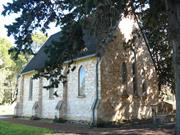
Lot 1 Weld St Gingin
Weld Street opposite the Brockman Street intersection. Lot 1 on Diagram 946.
Gingin
Avon Arc
Constructed from 1860
| Type | Status | Date | Documents |
|---|---|---|---|
| Heritage List | Adopted | 17 Oct 2017 | |
| State Register | Registered | 08 Oct 1996 | HCWebsite.Listing+ListingDocument, HCWebsite.Listing+ListingDocument |
| Type | Status | Date | Documents |
|---|---|---|---|
| (no listings) |
| Type | Status | Date | Grading/Management | |
|---|---|---|---|---|
| Category | ||||
| Municipal Inventory | Adopted | 17 Oct 2017 | Category A | |
| Classified by the National Trust | Classified | 03 Jul 1978 | ||
| Register of the National Estate | Permanent | 28 Sep 1982 | ||
| Anglican Church Inventory | YES | 31 Jul 1996 | ||
The building is in original condition.
| Name | Type | Year From | Year To |
|---|---|---|---|
| Rev George Sadler | Architect | 1862 | - |
| Library Id | Title | Medium | Year Of Publication |
|---|---|---|---|
| 4101 | Conservation Project St Lukes Anglican Church Gingin: Final Report | Heritage Study {Other} | 1999 |
| 978 | St Lukes Church Gingin: Conservation Plan | Heritage Study {Cons'n Plan} | 1995 |
| 3569 | St Luke's Anglican Church Gingin Conservation Works Stage2-Final Report | Heritage Study {Other} | 1998 |
| 3920 | Gingin Townscape Project | Report | 1991 |
Individual Building or Group
| Epoch | General | Specific |
|---|---|---|
| Present Use | RELIGIOUS | Church, Cathedral or Chapel |
| Original Use | MONUMENT\CEMETERY | Cemetery |
| Original Use | RELIGIOUS | Church Hall |
| Style |
|---|
| Vernacular |
| Victorian Free Gothic |
| Type | General | Specific |
|---|---|---|
| Roof | TIMBER | Shingle |
| Wall | STONE | Limestone |
| General | Specific |
|---|---|
| SOCIAL & CIVIC ACTIVITIES | Religion |
| DEMOGRAPHIC SETTLEMENT & MOBILITY | Settlements |
| PEOPLE | Early settlers |
This information is provided voluntarily as a public service. The information provided is made available in good faith and is derived from sources believed to be reliable and accurate. However, the information is provided solely on the basis that readers will be responsible for making their own assessment of the matters discussed herein and are advised to verify all relevant representations, statements and information.
The building and its precinct dominate the town centre and are a focus for future development activities. The most significant building in the town of Gingin. Has great historical associations for a wide area and considerable structural merit. Surrounded by the graveyard of the pioneers of the district.
St Luke’s Church of England was built in 1861. This lovely example of Gothic church architecture is built of coursed limestone. Set in it graveyard of pioneers of the district it has headmarkers of timber and stone together with its freestanding bell tower and sheltering trees. Church consecrated 22.11.1885, opened 23.2.1861. Oldest tombstone 1859 (Doncaster). Iron roof replacing shingles. Three light East window and diamond paned side windows. Embossed grisaille. The door has a massive locking key and in the porch are two arrow slit windows with white internal splays. Pew, pulpit, lectern and communion rails are local craftmanship. Font dated 1861. In 1960 service held to commemorate centenary of the Church.
Assessment 1978 Construction 1861 Opened 23.2.1861 Consecrated 22.11.1885 Oldest tombstone 1859 (Doncaster).
This information is provided voluntarily as a public service. The information provided is made available in good faith and is derived from sources believed to be reliable and accurate. However, the information is provided solely on the basis that readers will be responsible for making their own assessment of the matters discussed herein and are advised to verify all relevant representations, statements and information.
St Luke's Church, Cemetery and Belfry is significant as the first purpose-built place of worship in Gingin; and for close associations with European settlers of the Gingin district, some of whom are buried in the graveyard. The place is historically important as an example of a nineteenth century Anglican Parish Church, dating from the 1860s, set in a graveyard dating from the 1850s; and contributes to the community's sense of place as a reminder of the mid-nineteenth century development of the Ging in district and the role of religion in that development. The Church, belfry and cemetery area landmark in the setting of mature Cypress tress.
Located on the north bank of Gingin Brook, the church faces Weld Street, with an access on the north side as well, where the belfry is located. The Cemetery is located in the Weld Street frontage. A low Gothic picket fence surrounds the site. The Church is a simple rectangular form with entry porch at the west end. The steep gable roof is clad with shingles. The street frontage has a full stone gable wall with 3 stained glass windows in vertical format with gothic arched tops. A tall central window is flanked by two shorter windows. The sidewalls have steeped buttresses at regular intervals. The belfry is timber framed with a shingled hipped roof over. The path though the Cemetery from the road frontage splits in two to each side of the church.
In c.1860, the Crown allocated 12 acres of land (Pt Swan Location 265) to the Anglican Church. The stone for the church was quarried nearby. The original building did not include a vestry. A grant of 25 pounds was received on completion of the building. The Reverend George Bostock was the first chaplain, opening the church for divine service on 23 February 1861. In c.1862, Reverend George Sadler took over and built a home, remaining in Gingin until 1884. In 1862, the bell was brought from the government offices in Perth, for use by the church and the school that was utilising the church in the 1870s and 1880s. In 1899, there was concern regarding overcrowding the cemetery, and the proximity to the brook. In 1904 the Cemetery was closed except for those interred with relatives. There are many unmarked graves in the Cemetery.
Integrity : High degree Authenticity : Moderate/high degree
Good
| Ref ID No | Ref Name | Ref Source | Ref Date |
|---|---|---|---|
| H Udell: "History of Gingin". p 154 & 276 |
| Owner | Category |
|---|---|
| Perth Diocesan Trustees | Church Property |
This information is provided voluntarily as a public service. The information provided is made available in good faith and is derived from sources believed to be reliable and accurate. However, the information is provided solely on the basis that readers will be responsible for making their own assessment of the matters discussed herein and are advised to verify all relevant representations, statements and information.
Lot 2 Weld St Gingin
Lot 2 on Diagram 946. Set back a considerable distance from the church.
St Lukes Rectory
Gingin
Avon Arc
Constructed from 1898
| Type | Status | Date | Documents |
|---|---|---|---|
| Heritage List | Adopted | 17 Oct 2017 | |
| State Register | Registered | 13 Dec 1996 | HCWebsite.Listing+ListingDocument, HCWebsite.Listing+ListingDocument |
| Type | Status | Date | Documents |
|---|---|---|---|
| (no listings) |
| Type | Status | Date | Grading/Management | |
|---|---|---|---|---|
| Category | ||||
| Municipal Inventory | Adopted | 17 Oct 2017 | Category A | |
| Register of the National Estate | Permanent | 28 Sep 1982 | ||
| Anglican Church Inventory | YES | 31 Jul 1996 | ||
| Classified by the National Trust | Recorded | 03 Jul 1978 | ||
01085 St Luke's Anglican Church, Cemetery and Belfry
Timber verandah, floor largely replaced by concrete; brick addition at rear houses service areas.
Individual Building or Group
| Epoch | General | Specific |
|---|---|---|
| Present Use | RESIDENTIAL | Single storey residence |
| Original Use | RELIGIOUS | Housing or Quarters |
| Style |
|---|
| Federation Bungalow |
| Type | General | Specific |
|---|---|---|
| Roof | METAL | Corrugated Iron |
| Wall | STONE | Other Stone |
| Roof | METAL | Pressed Metal |
| Wall | TIMBER | Other Timber |
| General | Specific |
|---|---|
| SOCIAL & CIVIC ACTIVITIES | Religion |
This information is provided voluntarily as a public service. The information provided is made available in good faith and is derived from sources believed to be reliable and accurate. However, the information is provided solely on the basis that readers will be responsible for making their own assessment of the matters discussed herein and are advised to verify all relevant representations, statements and information.
Constructed from 1898
St Luke's Rectory is associated with the development of the Anglican parish in Gingin, Reverends who served the Church, and demonstrates a way of life no longer practiced.
No inspection in 2016.
The rectory is located to the northwest of the church. It was built for Ed Pritchett (for the church).
Timber verandah, floor largely replaced by concrete; brick addition at rear houses service areas.
| Ref ID No | Ref Name | Ref Source | Ref Date |
|---|---|---|---|
| H Udell: "History of Gingin". p 154 & 276 |
| Owner | Category |
|---|---|
| Perth Diocesan Trustees | Church Property |
This information is provided voluntarily as a public service. The information provided is made available in good faith and is derived from sources believed to be reliable and accurate. However, the information is provided solely on the basis that readers will be responsible for making their own assessment of the matters discussed herein and are advised to verify all relevant representations, statements and information.
2465 Mogumber Rd Mindarra
Mogumber Farm
Mogumber Mission Settlement
Moore River Native Settlement
Gingin
Avon Arc
Constructed from 1918
| Type | Status | Date | Documents |
|---|---|---|---|
| Heritage List | Adopted | 17 Oct 2017 | |
| State Register | Registered | 07 Apr 1998 | HCWebsite.Listing+ListingDocument, HCWebsite.Listing+ListingDocument |
| Type | Status | Date | Documents |
|---|---|---|---|
| (no listings) |
| Type | Status | Date | Grading/Management | |
|---|---|---|---|---|
| Category | ||||
| Aboriginal Heritage Sites Register | Permanent | |||
| Register of the National Estate | Registered | 30 May 1995 | ||
| Municipal Inventory | Adopted | 17 Oct 2017 | Category A | |
| Name | Type | Year From | Year To |
|---|---|---|---|
| A O Neville, Chief Protector of Aborigines | Architect | - | - |
| Library Id | Title | Medium | Year Of Publication |
|---|---|---|---|
| 1677 | Mogumber cemetery memorial project | Report | 1997 |
| 11658 | Moore River Native Settlement/Mogumber Mission management plan | Heritage Study {Other} | 1997 |
| 26 | Pictorial collection of the Moore River Native settlement 1917-1965 | Report | 1990 |
| 11659 | Moore River Native settlement : Heritage landscape survey and management report AND Aboricultural survey and management report (1999) | Heritage Study {Other} | 1998 |
| 4043 | Moore River Settlement Church Conservation Works Final Report | Report | 1999 |
| 4502 | Report on an assessment of cultural significance and a conservation plan for the Moore River native settlement (the Mogumber Mission and cemetery). | Heritage Study {Cons'n Plan} | 1994 |
| 7468 | The stolen generations : separation of Aboriginal children from their families. | Book | 1999 |
| 7202 | Echoes of the past : Sister Kate's Home revisited. | Book | 2002 |
| 1168 | Sort of a place like home : remembering the Moore River Native Settlement. | Book | 1993 |
| 7960 | For their own good: Aborigines and government in the south west of Western Australia 1900 - 1940. | Book | 1992 |
Individual Building or Group
| Epoch | General | Specific |
|---|---|---|
| Original Use | RESIDENTIAL | Other |
| Other Use | FARMING\PASTORAL | Other |
| Present Use | RESIDENTIAL | Other |
| Style |
|---|
| Other Style |
| Type | General | Specific |
|---|---|---|
| Roof | ASBESTOS | Other Asbestos |
| Wall | TIMBER | Weatherboard |
| Wall | STONE | Donnybrook Sandstone |
| General | Specific |
|---|---|
| PEOPLE | Early settlers |
| DEMOGRAPHIC SETTLEMENT & MOBILITY | Aboriginal Occupation |
| DEMOGRAPHIC SETTLEMENT & MOBILITY | Racial contact & interaction |
| PEOPLE | Aboriginal people |
| DEMOGRAPHIC SETTLEMENT & MOBILITY | Government policy |
| DEMOGRAPHIC SETTLEMENT & MOBILITY | Settlements |
This information is provided voluntarily as a public service. The information provided is made available in good faith and is derived from sources believed to be reliable and accurate. However, the information is provided solely on the basis that readers will be responsible for making their own assessment of the matters discussed herein and are advised to verify all relevant representations, statements and information.
Mogumber Mission (fmr) and Cemetery, a site containing the remains of buildings, structures and camping places relating to the Moore River Native Settlement (1917-1951) and to the Mogumber Methodist Mission (I951-1967), and including a gazetted cemetery, is of cultural heritage significance for the following reasons: • the place is probably the most important site in Western Australia representing government policies, social attitudes and racist theoretics towards Aboriginal people throughout the twentieth century; • the place represent the effects of the Aborigines Act 1905 on Aboriginal people from all over Western Australia; • the place was one of the main government settlements in Western Australia of Aboriginal children from all parts of the state, who were removed from their families, relocated and detained against their will between 1917 and 1951; • the place is a benchmark site for teaching the history of Aboriginal culture in Western Australia from the time before European settlement to the present; it has potential to provide valuable insights into the development of the relationship between Aboriginal and non-Aboriginal people in the region and the state and to contribute to the process of reconciliation; • the place is important to a large section of the Aboriginal community in Western Australia for cultural, religious, social and educational associations; • the cemetery is an important social and spiritual centre for the high percentage of Aboriginal families in Western Australia who have relatives buried there, and is one of the largest Aboriginal burial grounds in Austra lia; • the place is important for the ways in which traditional Aboriginal culture and language were influenced by the bringing together of people of diverse Aboriginal backgrounds from across the state; • the place is important for its association, from the 1950s, with the phase of history influenced by missions for Aboriginal people run by religious organisations; • the place is important for associations with a number of prominent members of the Aboriginal community including a number of elders and notable Aboriginal spokespersons; • the place has historic value for its associations with A.O. Neville, Chief Protector of Aborigines from 1915 to 1940; • the place is important because its aesthetic qualities evoke memories of the history of generations of Aboriginal children who lived there from 1917 to the late 1960s; the visual beauty of the setting including remnants of the settlement and mission give the place a peaceful quality which belies its history; and • the place is important for its integration of the physical remnants of the settlement with its landscape setting - the components together creating a significant cultural landscape. The aesthetic value of the setting is characterised by a feeling of the overall dominance of natural features; of particular importance is the proximity of the place to the river which also has spiritual significance for Aboriginal people. In 1996, a new house was constructed on the northern side of the entrance to the mission area. This is clearly separate from the mission buildings and is of little significance. Prior to this, however, a new toilet block was constructed on the site. In itself the building is of little significance , however it has been located within the settlement area in the approximate location of the former chapel and hospital and is consequently an intrusive element. Water tanks sited within the location of the former staff quarters are also considered intrusive to the significance of the place. Aesthetic Value The aesthetic value of the place to those associated with it, is derived from the memories that are prompted by the visual components of the place. In aesthetic terms the place is beautiful. The physical beauty is derived from the setting and the individual components that comprise the cultural environment. The remnants of the settlement and mission which remain, however, are the components which give the place aesthetic value beyond the visual beauty of the setting. The cemetery is of aesthetic significance to those associated with the history of the place and to the Aboriginal community in Western Australia. The grave markers of shell and cast iron crucifixes represent a memorial to those who died there and the tranquillity and isolation of the site serve to reinforce the poignancy that the aesthetic of the place evokes. The aesthetic value reinforces the spiritual significance to the place. The remnants of the settlement including buildings, trees, roadways and other elements remain within a dominant landscape which is characterised by natural elements including the topography of the site, river and the surrounding farmland. The aesthetic value of the setting is characterised by a recognition of the overall dominance of natural features and in particular the river. The aesthetic significance of the setting is reinforced by the pine plantation which remains the visually most dominant aspect of the settlement's history and gives a sense of peacefulness to the place. The aesthetic value of the place is due to the contributing effect of a number of element which combine to form a significant precinct. These elements include: • picturesque avenues of mature introduced species of pines and other trees that mark the street where buildings have disappeared; • the remaining structures from the settlement period including the church, isolation ward, former administration building, butchers' shop and gaol; • 'ruins ' indicating the location of former buildings, such as the Superintendent's house, dormitories, laundry and other structures no longer extant; and, • the remaining structures from the mission period including the houses, Nissen huts, swimming pool and tennis court. Historic Value The place represents the various phases of Aboriginal settlement including the traditional camping grounds adjacent to the Moore River, known as 'Palm Flats', the period of the government settlement represented by the Moore River Native Settlement from 1917 to 1951 and the mission period represented by the Mogumber Methodist Mission during the 1950s and 60s. The place not only evidences the different lifestyles and settlement patterns of Aboriginal people on the Moore River, but also the changes that have affected Aboriginal people all over the state, in particular as a result of the influences of the Aborigines Act 1905. The place is of historic significance as one of the main government settlements in Western Australia for Aboriginal people from all over the State who were relocated and detained between 1917 and 1951. The place is of historic significance for its association with the Mogumber Methodist Mission from 1951 to 1968. The place is of historic significance for association with numerous Aboriginal children from across the state who where removed from their families and grew up at Moore River. This group of people is historically significant, representing those immediately effected by government policy and community attitudes of the day. The place is of historic significance for association with a number of prominent members of the Aboriginal community over the history of the settlement from 1917 to the present including a number of elders and notable Aboriginal spokespersons such as Jack Davis. The place is of historic significance for associations with A.O. Neville, Chief Protector of Aborigines from 1915 to 1940, whose administration directly effected the lives of the residents of the Moore River Native Settlement during that period. Scientific Value The place is of scientific significance as a benchmark site for teaching the history of Aboriginal culture in Western Austral ia from the time before European settlement to the present. The place includes traditional Aboriginal camping grounds, spiritual sites and burial grounds as well as being the site of the Moore River Native Settlement and the Mogumber Methodist Mission. The place is of scientific significance for its ability to reveal information about the various aspects of Aboriginal history and culture and in particular to understand the effect the Aboriginal Act 1905 had on the Aboriginal and non-Aboriginal people of Western Australia. It has potential to provide valuable insights into the development of relation ship between Aboriginal and non-Aboriginal people in the region and the State. Social Value The place is of social significance as probably the most important site in Western Australia representing the government policies and social attitudes towards Aboriginal people throughout the twentieth century. The place represents some implementation of the racist policies of the Aborigines Act 1905 including the removal and relocation of people, the re-education of Aboriginal people and eradication of Aboriginal culture, and other associated practices. For these reasons the place is of social, cultural, scientific and educational significance to the whole community in Western Australia and presents opportunities for social and cultural interchange and reconciliation . The place is of social significance to the Aboriginal community in Western Australia. Those associated with the Moore River Native Settlement and Mogumber Methodist Mission came from many parts of Western Australia and therefore families from all parts of the state have associations with the place. The cultural, religious, social and educational associations with the place are an integral part of life for many former residents and their famil ies. The place is of social significance for the effects it had on traditional Aboriginal culture and language, both of the local area and of the whole of Western Australia. The place is of social significance to the numerous Aboriginal people from across Western Australia for whom the place provides the only memories of a childhood home. It is also significant to the high percentage of Aboriginal families who within living memory have associations with the place through family members. Association s with the place include both positive and negative experiences, perceptions and emotions. The cemetery is of social and spiritual significance to the high percentage of Aboriginal families in Western Australia who have ancestors and relatives buried there, and is one of the largest Aboriginal burial grounds in Australia. Rarity The Moore River Native Settlement was one of only two comparable examples of a settlement established by the government in the early twentieth century for the purpose of relocating Aboriginal people. The settlements were established with the aim of teaching farming practices and domestic skills for the purpose of 'civil ising' Aboriginal people for integration into the white society. The other settlement was at Carrolup Reserve near Katanning which was settled mainly by people from the south west region and was more restricted in its area of influence. Although there are a number of examples of institutions including children's homes, missions and reserves, which represent aspects of life for Aboriginal people in twentieth century Western Australia, Moore River is unique in Western Australia for its size, purpose and extent of influence. For this reason it has a high degree of rarity. Representativeness The place is representative of a highly significant phase in Aboriginal/European relations in Western Australia. It represents the effects of racist and repressive government policy on the lives of Aboriginal people in the State throughout the twentieth century. Condition The physical condition of the place has varied considerably depending largely upon the attitudes and management practices of the various superintendents or administrators. In the late I 940s the removal and/or demolition of structures from the settlement occurred followed by further loss of buildings in the 1960s and 70s after the closure of the Mogumber Methodist Mission. During the subsequent period the maintenance of the settlement has been varied. The remaining buildings from the mission period have had a program of maintenance and renovation and are in generally good condition. The buildings remaining from the settlement period include two buildings that have been renovated and several which are in fair to poor condition. Generally the condition of the site does not affect the assessed significance of the place. Integrity The majority of buildings in the settlement are no longer extant, however the remaining buildings are a good representative sample of what once existed and the landscape elements, most notably the internal 'street' remain fairly intact. At present only the Mission buildings are in use - primarily for residential and office use which is compatible with the significance of the place. The settlement buildings are not used. With care, the integrity of the place, which is high, can be sustained in the long term. Authenticity The authenticity of the Mogumber Mission (fmr) and Cemetery is high, since little has been done at the site. since the closure of the Mission. The cemetery, despite gazettal as any other common cemetery, has not been used for general burial purposes of the district. The fabric of the church, administration building and butcher's shop are of high authenticity, having had little or no modification since closure of the Mission and possibly the settlement. The detention centre and isolation block have been recently 'restored'. This work was not based on conservation principles and is not greatly intrusive although significant details in the detention centre have been removed - most notably the removal or painting over of all graffiti. Similarly, the Mission buildings have had maintenance work recently completed and these buildings are generally of moderate authenticity. The cemetery burial area is of high authenticity and was untouched during recent work on the cemetery memorial project.
'The settlement sits on a natural terrace above the Moore River from which are had panoramic views as far as the north, west and south horizons, which are formed by ridgelines of the hills opposite' . 'The Mogumber Mission (fmr) and Cemetery is located within an operational farming property, vested in and operated by the Wheatbelt Aboriginal Corporation , and formerly the 'Settlement's' farming lands. It is a rural property with extensive cover of native shrubs and trees .... Within which are located sites relating to pre contact and post-contact traditional Aboriginal use (including traditional burials), early European settler fanning, and the remains of the 'Settlement' buildings, structures and camping sites relating to the 'Settlement' period. Within the property, some distance from the 'Settlement', lies a gazetted cemetery, in which are interred many former Aboriginal residents of the 'Settlement' . The place is entered via a gravel driveway which extends past the Mission buildings to the 'Settlement' and on towards the farm. These areas form three separate groups of buildings which are described below: Mission Buildings On the northern side of the entrance driveway are three houses. The first has been recently built; the other two are sited within a large plantation of pine trees which date from the Settlement period. These are timber framed, asbestos clad buildings with zincalume roof sheeting, typical of c.l950s construction. South of the entrance driveway is a cleared sandy area with some grass covering. There are four buildings of similar c.1960s design in this location which have recently been renovated. Two are used as dormitory-style accommodation and one as an office, meeting and exhibition space. The fourth, which is closest to the road, contains a commercial kitchen and dining hall. This building has weatherboard cladding to window height and asbestos above. There is also a small store building of similar construction. They are all in good condition. Included in this group of buildings is the 'isolation block' which was constructed during the 'Settlement' period away from the other buildings. This will be described in the next section. West of the Mission buildings is a tennis court which has a bitumen surface in very poor condition and is surrounded by a high cyclone fence. On either side of the court are two Nissen huts which are clad in rusting CG! sheets and have concrete floors. There is a caravan parked on the western side of the tennis court which is currently occupied. Also on the western side of the tennis court is a recently constructed toilet block which is of steel frame construction with rendered masonry and zincalume clad walls and a curved zincalume roof. 'Settlement' Most of the buildings constructed as part of the 'Settlement' have since been demolished or removed from the site. However, enough physical evidence remains to retain a sense of the place having existed. This is primarily due to the substantial church hall which is located at the southern end of the former 'street' along which many of the structures were located. The street is defined by remaining pine trees and terminated by the site on which the Superintendent's house was located. The following physical description has been taken from the archaeological study: Church Hall 1920 'The remains of the original building on the site can be seen, they are visible under the existing building and are of stone and mortar construction. The current building is a wooden structure approximately 18m x 12m at its widest point and is an L shaped building. Its current state of preservation is good though some work could and should be carried out. The church was originally weatherboard but has been clad externally in asbestos sheeting which is in fair condition. The roof sheeting is unpainted CGI which is in fair to poor condition. Internally, the main hall is clad in horizontal timber boarding with some sections in fluted iron. The ceiling is plaster sheeting and the floor timber. A recent structural report has stated that the building appears to be structurally sound, however the finishes generally are in poor condition. Detention Block 1946 '... is of limestone and concrete construction and consists of a number of small cells and a larger communal cell. The dimensions of the building are approximately l0m x 9m with the smaller cells being approximately 2111 x 3m . Since this report, the building has been 'restored' graffiti has been removed, the walls repainted and a new roof added. Butcher 's Shop 1928 This building is timber framed with weatherboard cladding to window height. It has an unpainted CGI roof. It was, until recently, in good condition structurally, however a pine tree fell and badly damaged the western half. Girls' Dormitory constructed 1919, additions 1922, demolished c.1948? '... the building has been demolished and little remains of the original structure. The location of the Girls Dormitory can be established quite clearly, but the integrity of the site has been completely destroyed. Boys' Dormitory temporary construction 1920, ' . .. the building has been demolished and the site has been largely cleared with very little evidence of the building. From the physical survey and the information provided by existing records the location of the Boys' Dormitory can be quite clearly established.' Staff Quarters 1920 'The site has been largely demolished and much of the main buildings have been removed ... Although the main staff building has had all but the foundations for the building removed the staff building compound remains and has a number of features of interest included in it. The existence of clear gardens can still be seen and the surrounding wall itself is of great interest in demonstrating the building techniques employed at the site. The integrity of the site has been altered somewhat by the construction of a number of cement water tanks ...' Superintendent's Quarters 1918 '... situated on the premier site in the settlement with expansive view over he surrounding area and overlooking the river. The site has been cleared and little, except for a few foundation stones remain . Some landscape items, such as trees and fences also remain. Assistant's Cottage 1921 '... was located, according to departmental plans, at the north end of the main avenue on the eastern side. The cottage was at various stages improved upon and extended, however the physical site shows very little remain s in the area where the cottage should be... Dining Room & Kitchen/Bakehouse 1926 '... were located near the hall at the south west end of the settlement avenue. This site is mapped on the original plans 1926, but the area shown on the plan, when surveyed, revealed little to suggest the remains of a building at the location although there was some debris at this site.' Kinder garten c.1937 '... is positioned to the east of the main avenue in later plans. Very few remains of the buildings came from the survey of the area...' Washroom c. l 920s 'The location of this building is mapped on the original 1926 plan, however the site where it is situated has been covered with debris form the donnitory sites. Hospit al 1928 'The location of the building is extremely difficult to ascertain. Some of the later plans place the hospital to the east of the old settlement in the area which is now occupied ... it is likely that one of the current buildings is, or was built upon the hospital. Store/Office c.1949 The original building was of a wood and iron construction and its location can be clearly seen on early plans of the site on the west side of the main avenue. The site which is specified in those plans has a building of brick, stone and tile construction on the site . This later description appear to refer to the extant building which is of a domestic style, constructed from concrete block of a type commonly used in the post war period. The walls are painted. Window frames are timber casement and the roof is clad in painted CGI sheeting. Internally, the building has concrete floors. Structurally it is in good condition, however finishes are generally in fair to poor condition. Other There are various other remains of structures, generally retaining elements of floor structure and foundations only. Not all have been identified , however. Cemetery The cemetery is a gazetted burial site located away from the settlement area on the West Mogumber Road. It has a gravel access road, recently upgraded as part of a National Estate Grants Program project. This project involved landscaping around the cemetery, the construction of a memorial for the people buried there and fencing of the cemetery itself. The burial area does not have any formally marked graves, however there are some iron crosses and groups of shells. A 'ground-probing radar' survey completed in 1993 showed the number and location of burials within the cemetery and identified some bodies at 'The Elbow' site along the river. The burial area at the cemetery is covered with indigenous vegetation that is largely undisturbed. Fa rm Buildings There are numerous buildings, sheds etc, that relate to the farming but have not been discussed in this physical evidence section.
Assessment 1998 1903 Diagrams 29196 and 29198 show Swan Locations surveyed in the area with J Atkinson as 'lessee or Grantee.' 1904 '...serious allegations concerning the treatment and condition of Aborigines employed in the pastoral indust1y were creating a storm in state Parliament. This led directly to the appointment of the Roth Royal Commission in 1904 and to the proclamation of the 1905 Aborigines Act'. Roth was commissioned to report on: the administration of the Aborigines Department; Aboriginal prisoners; the distribution of relief to Aborigines; and the general treatment and condition of the state's Aboriginal popu lation. 7 Early Settlement Period 1905-1924 1905 Passing of the Aborigines Act, providing increased powers for the removal and relocation of Aborigines. The stated aims of the Act were to provide for the better protection and care of the state's Aboriginal population, but in reality it was a racist Act as it defined Aboriginality on the bases of biology, rather than identification or lifestyle. 'In fact it laid the bases for the development of repressive and coercive state control over the state's Aboriginal population. It lumped a broad range of disparate persons together in a special legal category based on vague notions of Aboriginal ancestry and lifestyle. It set up the necessary bureaucratic and legal mechanisms to control all their contacts with the wider community, to enforce the assimilation of their children and to determine the most personal aspects of their lives' The Chief Protector of Aborigines was responsible for the administration and execution of the Act. Under section 8 of the Act, he was 'the legal guardian of every aboriginal and half-caste child until such child attains the age of 16 years and had the right to remove children from their homes to missions or other institutions. 1915 A.O. Neville appointed Chief Protector of Aborigines in Western Australia. Neville was responsible for the development of the 'native settlement scheme' which 'provided a compromise between demands for the segregation of Aborigines from the wider community, the continuing need for Aboriginal labour and [a] determination to devise a solution involving an absolute minimum of expenditure. The scheme was seemingly self-contradictory based on the segregation of Aborigines on government-run farming settlements, it had as its ultimate aim their absorption into the wider community. Carrolup Reserve (reserve no. 9089 . not gazetted but reported in AD 725/1915) was established near Katanning, in the south of the State as the first 'native settlement. Throughout the early 1900s there were extensive difficulties for Aboriginal people in rural areas due to the spread of settlement, loss of traditional camping grounds and difficulties obtaining employment. As a result there was a general movement towards towns, with the greatest concentrations of Aboriginal people at Katanning and Moora. 1916 Carrolup Reserve was expanded to 10,000 acres to enable the development of a self-supporting agricultural settlement. 1917 Establishment of the Moore River Native Settlement (reserve no. 16833 GG2/I111917) at Mogumber on 9,600 acres of land, twelve of which had been cleared previously by farmers. The area was known as 'Palm Flats' and is described as 'an old meeting ground for the tribes. The land was thought to be suitable for a farm that would soon become self-sufficient, but this did not prove to be the case. Moore River was initially conceived as a settlement station for Southern and Midland Aboriginal people, but the catchment area quickly expanded to include the Eastern goldfields, Murchison, Pilbara and the Kimberleys. Although the place was established as a training farm for the Aboriginal people, their education was not confined to learning the skills of domestic servitude and labouring. Through their isolation on the settlement, the Aboriginality of the 'inmates' was controlled and trained out, and they were expected to adopt, either willingly or unwillingly, appropriate (white) forms of behaviour. Plans for the settlement drawn up and early burials are located at 'the Elbow' and north east of the cemetery. The first shelters (for the white staff) were tents. Between 1915 and 1920, expenditure on missions was cut back by half - gradually phasing them out of their role with children, who were sent instead to the settlements. Ellensbrook was the first children's mission to close in 1917. 1918 Aboriginal inmates averaged 22 in number. The first building was constructed - a cottage, used as an office, store and assistant' s room. The Superintendent's five-roomed bungalow was built (the "big house") and a camp site for the natives was selected and cleared. 1919 93 'inmates' were registered. A baker's oven was constructed, a dormitory for the young female inmates was completed along with a bake and cook house and a 'large shelter shed with a large open fireplace. During this year, new laws came into force, under which an Aboriginal person of any age, from any part of Western Australia, could be removed from his or her place or residence and interned within the reserve. 1920 By June, the population of the settlement had reached 158. This brought intensive building activity including construction of the school hall (also to be used for concerts and as a church), levelling of the street, and construction of staff quarters. Also constructed were a stable, sheds, a temporary dining room and a temporary boys' dormitory. Road works were undertaken including a small bridge across the main stream and a substantial stock yard. The settlement split its own fence posts and constructed furniture for the new school. 1921 Health problems were becoming more obvious; the doctor from Moora requested isolation and maternity wards be constructed. Fresh water was a persistent problem, despite digging numerous wells. Due to the lack of water, fresh vegetables, meat and milk were 'practically unknown'. Inmates supplemented their diet with kangaroos and fish and yabbies from the river. One acre of land was set aside for use as a cemetery (reserve no. l 7702GG 20/5/1921). Building works included repairs to the church/school hall, alteration of kitchen facilities and a new tradesman's hut and assistant's quarters. The manufacture of clothing for Aboriginal people (and other government departments) began at the settlement. 1922 Closure of the Carrolup River Native Settlement in the south and removal of most of its inhabitants to Moore River. Following concern over the water supply, an oil engine and pump had been installed to pump water from the river. Additions to the girls' dormitory, a new kitchen built next to the dining hall, the two-ward hospital and wash house and bath rooms built and a sewing room constructed. Six thousand garments were made by the women at the settlement.42 1924 More than one thousand blankets and seven thousand garments were made by the 'sewing room girls'. Reference is made to the fencing of the whole compound. The 'Boob' also appears in records. Middle Settlement Period 1925-1934 I 925 Introduction of new Superintendent John Brodie whose attitude was 'less of fatherly concern, ... and more of containment, control and full integration'. 1927 Brodie resigned following an incident where a young male inmate had been tarred and feathered. Arthur Neal took up the position and his wife took over as Matron. 'At the same time, extra funding was set aside to upgrade the settlement's farming activities. The settlement reserve was also increased in area to allow for the planting of a pine plantation by the inmates' . 1928 More than 300 people lived at the settlement (intended to house a maximum of 200 people). Over two hundred were accommodated at the settlement, while at least 100 people lived in camps on the site. Facilities included a slaughter-house and yards, butcher 's shop and a carpenter's shop. Preoccupations of the settlement supervisor relate to repairs and maintenance and the provision of better washing and sanitary facilities. The original buildings had been built from second-rate material in a short time and ablution facilities were minimal. 1929 A hospital constructed to alleviate epidemics of diseases, such as measles, pneumonia, scabies and ch ickenpox, that were exacerbated by over-crowded living conditions and poor diet. This building had two eight-bed wards, a kitchen, offices and nurses' rooms, and was built of lime and cement concrete. 1932 Policy during the Depression was to bring as many people as possible into the settlement and other institutions. The population at Moore River reached its peak at nearly 500 people.so At the same time, Government funding was slashed and living conditions that were never good deteriorated further. 1933 The Aboriginal population of Northam is taken to the settlement.s1 Late Settlement Period 1934-1951. 1934 A Royal Commission was established into Aborigines which gave a very critical account of the settlement. 1935 £500 granted by the Lotteries Commission to extend and complete the hospital. This work included a men 's ward, surgery and operating theatre, nurses ' quarters, medical ward, children's room and offices. The Lotteries Commission also financed the construction of an electricity plant. Treasury made available money to renovate all other buildings. A cow shed with yards and a lined two-roomed cottages was built. 1937 Lotteries and Treasury financed the construction of an infant's dormitory for 24 children, with a kindergarten and domestic sciences and manual training rooms for older children. Funds granted for a new;'native village'. The site was surveyed, roads and paths constructed and trees planted. Six camps for single men were re-built from camps in Geraldton. Eight two-roomed cottages were begun and thirty blocks marked out for further cottages. 1938 Six cottages, a cook house and recreation room had been constructed in the village. 1939 A 0 Neville retired as Chief Protector and is succeeded by Bray. 1940 Superintendent Paget takes over from Neal. Bate describes this as 'a period ofrapid degeneration Camp accommodation is described as: '14 single camps, to hold 2 persons each, and 6 married couples cottages, these accommodate 40 adults with a few young children. The remainder, 46 at present, are camped in old dilapidated tin humpies ... People were still being brought into the overcrowded dormitories. Those that could not speak English, or whose names were difficult to pronounce, were given new names in '... a callous and racist fashion'. 1944 An outside inspector describes that 'the whole system [was] in a deplorable condition' Aboriginal people from Moore River write to Pe1th, complaining of the terrible conditions, resulting in a backlash of discipl ine, control and suppression by the supervisors. 1946 The detention block completed, replacing the shed known as the 'Boob'.62 1948 S G Middleton, with experience in papua New Guinea, took over as Commissioner of Native Affairs, bringing 'a new era of competence and active decision-making to the Settlement.' Seventeen buildings were demolished and replaced, others were extended or altered and 'a considerable amount of sanitation work' was completed. 1951 Following public debate, Middleton closed down the Settlement, believing that isolated institutions hindered government assimilation policies. The Government had little understanding of the situation, reporting that some inmates were 'blatantly exploiting the Institution by leading a life of complete idleness, wh ilst being fed and clothed and cared for, at the expense of the Govemment. The place was handed to the Methodist Overseas Mission and 'the inmates dispersed. Mission Yea rs 1951-1968 1951 Name change to Mogumber Methodist Mission and the place is administered by the Church. This was a period of gradual rehabilitation. The quarters were abandoned and new buildings were constructed on a site east of the original Settlement. Final Years 1968 - 1968 Legislation passed allowing Aboriginal people to be counted in the census and defining Aboriginality based on identification and custom, rather than biology. The Mission closed. 1973 The cemetery is vested in the Aboriginal Lands Trust. 1989 The land is vested in the Wheatbelt Aboriginal Corporation The cemetery at Mogumber Mission is one of the largest Aboriginal burial grounds in Australia, containing over 400, mainly unmarked , graves
This information is provided voluntarily as a public service. The information provided is made available in good faith and is derived from sources believed to be reliable and accurate. However, the information is provided solely on the basis that readers will be responsible for making their own assessment of the matters discussed herein and are advised to verify all relevant representations, statements and information.
Constructed from 1918
Mogumber Mission (fmr) and Cemetery is arguably the most important site in Western Australia representing the physical embodiment of government policies, social attitudes and racist theories towards Aboriginal people throughout the twentieth century. It represents the effects of the Aborigines Act 1905 on Aboriginal people from all over Western Australia, as one of the main government settlements of Aboriginal children from all parts of the state, who were removed from their families, relocated and detained against their will between 1917 and 1951. Mogumber Mission (fmr) is a benchmark site for teaching the history of Aboriginal culture in Western Australia and has potential to provide valuable insights to contribute to the process of reconciliation. Mogumber Mission (fmr) and Cemetery is important to a large section of the Aboriginal community for cultural, religious, social and educational associations and for those who have relatives buried there in one of the largest Aboriginal burial grounds in Australia. Mogumber Mission (fmr) is important for its association, from the 1950s, with the phase of history influenced by missions for Aboriginal people run by religious organisations. It is important for associations with a number of prominent members of the Aboriginal community including a number of elders and notable Aboriginal spokespersons, and for its associations with A. 0. Neville, Chief Protector of Aborigines from 1915 to 1940.
A site containing the remains of buildings, structures and camping places. The cemetery is located some 1 kilometre west of the mission on Mogumber Road. In an area of approximately 2 acres, there are approximately 500 graves, mostly unmarked. A memorial wall has been established. The settlement sits on a natural terrace above the Moore River from which are had panoramic view as far as the north, west and south horizons, which are formed by ridgelines of the hills opposite. The place is entered via a gravel driveway which extends past the Mission buildings to the 'Settlement' and on towards the farm. These areas form three separate groups of buildings which are described below: Mission Buildings On the northern side of the entrance driveway are three houses. The first has been recently built; the other two sit within a large plantation of pine trees which date from the Settlement period. These are timber framed, asbestos clad buildings with zincalume roof sheeting, typical of c. 1950s construction. South of the entrance driveway is a cleared sandy area with some grass covering. There are four buildings of similar c. 1950s design. The one closest to the road, contains a commercial kitchen and dining hall. This building has dado weatherboard cladding and asbestos above. Included in this group of buildings is the 'isolation block' away from the other buildings. West of the Mission buildings is a tennis court and a toilet block which is of steel frame construction with rendered masonry and zincalume clad walls and a curved zincalume roof. 'Settlement' Most of the buildings constructed as part of the 'Settlement' have since been demolished or removed from the site. However, the church hall is located at the southern end of the former 'street' along which many of the structures were located. The street is defined by remaining pine trees and terminated by the site of the Superintendent's house. Church Hall 1920 Timber framed fibrocement clad. Detention Block 1946 limestone and concrete construction and consists of a number of small cells and a larger communal cell. The remnants of structures and foundations inform of the extent of the establishment. Cemetery The cemetery has a gravel access road. The burial area does not have any formally marked graves, however there are some iron crosses and groups of shells.
The Moore River Native Settlement was one of only two examples of a settlement established by the government in the early twentieth century for the purpose of relocating Western Australian Aboriginal people with the aim of preventing part Aboriginal children from associating and later breeding with full blood Aboriginal people, and to teach farming practices and domestic skills for the purpose of 'civilising' Aboriginal people for assimilation into the white society. The 1905 Aborigines Act' increased powers for the removal and relocation of Aborigines. 1915 A. 0. Neville appointed Chief Protector of Aborigines in Western Australia, developed the 'native settlement scheme': based on the segregation of Aborigines on government-run farming settlements, with ultimate aim their absorption into the wider community'. 1917 Establishment of the Moore River Native Settlement at Mogumber on 9, 600 acres of land. Through the isolation of the settlement, the Aboriginality of the 'inmates' was controlled and trained out, and they were expected to adopt, either willingly or unwillingly, appropriate (white) forms of behaviour. 1918 Aboriginal inmates averaged 22 in number. The first building was constructed - a cottage, used as an office, store and assistant's room. The Superintendent's five-roomed bungalow was built and a camp site for the natives was selected and cleared. 1919 93 'inmates' were registered. A baker's oven was constructed, a dormitory for the young female inmates was completed along with a bake and cook house and a 'large shelter shed with a large open fireplace' During this year, new laws came into force, under which an Aboriginal person of any age, from any part of Western Australia, could be removed from his or her place or residence and interned within the reserve. 1920 population had reached 158. 1922 Closure of the Carrolup River Native Settlement in the south and removal of most of its inhabitants to Moore River. 1925 Introduction of new Superintendent John Brodie whose attitude was 'less of fatherly concern, and more of containment, control and full integration. 1927 Brodie resigned following an incident where a young male inmate had been tarred and feathered. Arthur Neal took up the position and his wife took over as Matron. 1928 More than 300 people lived at the settlement (intended to house a maximum of 200 people). Facilities included a slaughter-house and yards, butcher's shop and a carpenter's shop. 1929 A hospital was constructed to alleviate epidemics of diseases, such as measles, pneumonia, scabies and chickenpox, that were exacerbated by over-crowded living conditions and poor diet. This building had two eight-bed wards, a kitchen, offices and nurses' rooms, and was built of lime and cement concrete. 1932 Policy during the Depression was to bring as many people as possible into the settlement and other institutions. The population at Moore River reached its peak at nearly 500 people. At the same time, Government funding was slashed and living conditions that were never good deteriorated further. 1933 The Aboriginal population of Northam is taken to the settlement. 1934 A Royal Commission was established into Aborigines which gave a very critical account of the settlement. 1935 The hospital was completed including a men's ward, surgery and operating theatre, nurses' quarters, medical ward, children's room and offices. A cow shed with yards and a lined two-roomed cottages was built. 1937 Infant's dormitory for 24 children, with a kindergarten, and domestic sciences and manual training rooms for older children. Funds were granted for a new 'native village'. The site was surveyed, roads and paths constructed and trees planted. Six camps for single men were re-built from camps in Geraldton. Eight two-roomed cottages were begun and thirty blocks marked out for further cottages. 1938 Six cottages, a cook house and recreation room had been constructed in the village. 1937 A O Neville retired as Chief Protector and is succeeded by Bray. Superintendent Paget takes over from Neal. Bate describes this as 'a period of rapid degeneration'. 1944 An outside inspector describes that 'the whole system [was] in a deplorable condition'. Aboriginal people from Moore River write to Perth, complaining of the terrible conditions, resulting in a backlash of discipline, control and suppression by the supervisors. 1946 The detention block completed, replacing the shed known as the 'Boob'. 1948 S G Middleton, with experience in Papua New Guinea, took over as Commissioner of Native Affairs, bringing 'a new era of competence and active decision-making to the Settlement.' Seventeen buildings were demolished and replaced, others were extended or altered. 1951 Following public debate, Middleton closed down the Settlement, believing that isolated institutions hindered government assimilation policies. The place was handed to the Methodist Overseas Mission and 'the inmates dispersed'. Mission Years 1951 -1968 1951 Name change to Mogumber Methodist Mission and the place is administered by the Church. This was a period of gradual rehabilitation. The quarters were abandoned and new buildings were constructed on a site east of the original Settlement. Final Years 1968 - 1968 Legislation passed allowing Aboriginal people to be counted in the census and defining Aboriginality based on identification and custom, rather than biology. The Mission closed. 1973 The cemetery is vested in the Aboriginal Lands Trust.
Integrity : Moderate degree Authenticity : Low/Moderate degree
Fair - ruinous
| Ref ID No | Ref Name | Ref Source | Ref Date |
|---|---|---|---|
| Holroyd; "National Estate Study". | 1978 |
| Owner | Category |
|---|---|
| Aboriginal Lands Trust | State Gov't |
This information is provided voluntarily as a public service. The information provided is made available in good faith and is derived from sources believed to be reliable and accurate. However, the information is provided solely on the basis that readers will be responsible for making their own assessment of the matters discussed herein and are advised to verify all relevant representations, statements and information.
2465 Mogumber Rd Mogumber
Mogumber Burial Site
Gingin
Avon Arc
Constructed from 1902 to 1972
| Type | Status | Date | Documents |
|---|---|---|---|
| (no listings) |
| Type | Status | Date | Documents |
|---|---|---|---|
| (no listings) |
| Type | Status | Date | Grading/Management | |
|---|---|---|---|---|
| Category | ||||
| Municipal Inventory | Adopted | 18 Oct 2005 | Category A | |
| Register of the National Estate | Registered | 14 May 1991 | ||
03618 Mogumber Mission (fmr) & Cemetery
Historic Site
| Epoch | General | Specific |
|---|---|---|
| Original Use | MONUMENT\CEMETERY | Cemetery |
| Type | General | Specific |
|---|---|---|
| Roof | TIMBER | Other Timber |
| Wall | STONE | Other Stone |
| General | Specific |
|---|---|
| DEMOGRAPHIC SETTLEMENT & MOBILITY | Settlements |
| DEMOGRAPHIC SETTLEMENT & MOBILITY | Aboriginal Occupation |
| SOCIAL & CIVIC ACTIVITIES | Cultural activities |
This information is provided voluntarily as a public service. The information provided is made available in good faith and is derived from sources believed to be reliable and accurate. However, the information is provided solely on the basis that readers will be responsible for making their own assessment of the matters discussed herein and are advised to verify all relevant representations, statements and information.
Constructed from 1972, Constructed from 1902
The cemetery is important as the resting place of so many Aboriginal people It is situated in an unspoilt piece of bush land.
A short distance north of the Mogumber West Road. It is an area of approximately two acres. There are an estimated 500 graves, mostly unmarked A parking area, path, shelters and a memorial wall have been constructed. Some graves are marked with iron crosses.
This was a cemetery of the Aboriginal people from the Methodist Mission.
| Ref ID No | Ref Name | Ref Source | Ref Date |
|---|---|---|---|
| Holroyd; "National Estate Study". | 1978 |
This information is provided voluntarily as a public service. The information provided is made available in good faith and is derived from sources believed to be reliable and accurate. However, the information is provided solely on the basis that readers will be responsible for making their own assessment of the matters discussed herein and are advised to verify all relevant representations, statements and information.
Mooliabeenee Rd Mooliabeenee
Lot 120 on Diagram 67478
Moondap
Gingin
Avon Arc
Constructed from 1870
| Type | Status | Date | Documents |
|---|---|---|---|
| Heritage List | Adopted | 17 Oct 2017 | |
| State Register | Registered | 02 Sep 1997 | HCWebsite.Listing+ListingDocument, HCWebsite.Listing+ListingDocument |
| Type | Status | Date | Documents |
|---|---|---|---|
| (no listings) |
| Type | Status | Date | Grading/Management | |
|---|---|---|---|---|
| Category | ||||
| Register of the National Estate | Permanent | 28 Sep 1982 | ||
| Classified by the National Trust | Classified | 03 Jul 1978 | ||
| Municipal Inventory | Adopted | 17 Oct 2017 | Category A | |
The building shows evidence of having been built in two stages. There is a brick outhouse.
| Library Id | Title | Medium | Year Of Publication |
|---|---|---|---|
| 5016 | Moondah Homestead, Lot 120 Mooliabeenee Road, Gingin : conservation plan. December 2000. | Heritage Study {Cons'n Plan} | 2000 |
Individual Building or Group
| Epoch | General | Specific |
|---|---|---|
| Present Use | FARMING\PASTORAL | Kitchen |
| Other Use | FARMING\PASTORAL | Homestead |
| Original Use | OTHER | Other |
| Style |
|---|
| Victorian Georgian |
| Type | General | Specific |
|---|---|---|
| Wall | BRICK | Other Brick |
| Roof | TIMBER | Shingle |
| Roof | METAL | Corrugated Iron |
| General | Specific |
|---|---|
| DEMOGRAPHIC SETTLEMENT & MOBILITY | Settlements |
| OCCUPATIONS | Grazing, pastoralism & dairying |
| DEMOGRAPHIC SETTLEMENT & MOBILITY | Land allocation & subdivision |
| PEOPLE | Early settlers |
This information is provided voluntarily as a public service. The information provided is made available in good faith and is derived from sources believed to be reliable and accurate. However, the information is provided solely on the basis that readers will be responsible for making their own assessment of the matters discussed herein and are advised to verify all relevant representations, statements and information.
This homestead, built about 1880 has French windows and displays symmetry and typical colonial elements. The brick walls, which have been painted have string courses of brick work cement rendered to a height of 3 ft. The corrugated iron roof covers shingles over pitsawn rafters. A detached kitchen block at the rear is typical of the era. Together with its garden of mature trees it is recommended to be classified. An outstanding example of a gentleman's residence. Built and occupied (until his death in 1898) by William Brockman, a son of the founder of Cheriton. The best example of a Colonial Gentleman's Residence of the 1880's remaining in the district.
Assessment 1978 Construction c.1880
This information is provided voluntarily as a public service. The information provided is made available in good faith and is derived from sources believed to be reliable and accurate. However, the information is provided solely on the basis that readers will be responsible for making their own assessment of the matters discussed herein and are advised to verify all relevant representations, statements and information.
Constructed from 1870
Moondah Homestead is significant as one of the early farming establishments in the district, and for association with the Brockman family.
Single storey three room brick house with separate kitchen and garden with mature trees, close to Moondah Brook. The building shows evidence of having been built in two stages. There is a brick outhouse.
William Locke Brockman and his wife and son were one of the first settlers in the Swan River Colony in 1830, taking up Swan Location 9 (Herne Hill) in 1832 and establishing a family residence. Attracted to Gingin area due to streams and fertility, he took up Swan Locations 96, 101 and 104, and became renowned for pedigree sheep and breeding blood horses for the Indian Army. He was the first to lease grazing land in the area and establish flocks, and also facilitated the Church of England church. On location 96 he established Ginginup Station- later named Cheriton. Moondah Homestead was located at the south end of Ginginup Station. In c.1860, Brockman's second son William was managing Moondah Homestead that bred cattle and horses up to the turn of the century. After his wife's death in c.1868 he hired Mr and Mrs John McWilliams who lived at the homestead, housekeeping and working the farm. And did so until William's death in 1898. In 1887 ownership had transferred to William's sons Edmund and Henry, and then Henry, before it transferred again in 1904, to Williams' daughter Mary Elizabeth Hare, wife of Frederick Hare, Commissioner of Police. They leased the property until moving in in 1906 after the Commissioner became the target of an assassination attempt. In 1907, the property was acquired by Walter McKenzie Grant, who on sold to neighbour John Musk, inherited by his wife Catherine in 1921. Richard Rennie owned between 1924 and 1936, adding a kitchen, after which time many owners until 1968 when the Western Australian winegrowers Association purchased and established Valencia Vineyards. After the property changed hands again in 1991, a new residence was constructed and Moondah Homestead was vacant in 2005.
| Ref ID No | Ref Name | Ref Source | Ref Date |
|---|---|---|---|
| "National Estate Study, Technics 10". page 32 | 1978 |
| Owner | Category |
|---|---|
| GA Gifford | Other Private |
This information is provided voluntarily as a public service. The information provided is made available in good faith and is derived from sources believed to be reliable and accurate. However, the information is provided solely on the basis that readers will be responsible for making their own assessment of the matters discussed herein and are advised to verify all relevant representations, statements and information.
Neergabby
The Junction
Gingin
Avon Arc
| Type | Status | Date | Documents |
|---|---|---|---|
| (no listings) |
| Type | Status | Date | Documents |
|---|---|---|---|
| (no listings) |
| Type | Status | Date | Grading/Management | |
|---|---|---|---|---|
| Category | ||||
| (no listings) | ||||
15873 North West Stock Route (fmr) Stage 1
| Library Id | Title | Medium | Year Of Publication |
|---|---|---|---|
| 2120 | Neergabby (where the brook and river meet) : a history of the Moore River and lower Gingin Brook, 1830 to 1960. | Book | 1976 |
Other Built Type
| Epoch | General | Specific |
|---|---|---|
| Original Use | OTHER | Other |
| General | Specific |
|---|---|
| TRANSPORT & COMMUNICATIONS | Droving |
This information is provided voluntarily as a public service. The information provided is made available in good faith and is derived from sources believed to be reliable and accurate. However, the information is provided solely on the basis that readers will be responsible for making their own assessment of the matters discussed herein and are advised to verify all relevant representations, statements and information.

Lot 10 Gingin Brook Rd Neergabby
Lot 10 on Diagram 96547. South of road to Gingin c.3km from turnoff on Perth-Lancelin Rd.
Old Junction Hotel
Gingin
Avon Arc
Constructed from 1874
| Type | Status | Date | Documents |
|---|---|---|---|
| Heritage List | Adopted | 17 Oct 2017 | |
| State Register | Registered | 24 Nov 2000 | HCWebsite.Listing+ListingDocument, HCWebsite.Listing+ListingDocument |
| Type | Status | Date | Documents |
|---|---|---|---|
| (no listings) |
| Type | Status | Date | Grading/Management | |
|---|---|---|---|---|
| Category | ||||
| Municipal Inventory | Adopted | 17 Oct 2017 | Category A | |
| Aboriginal Heritage Sites Register | Permanent | |||
| Statewide Hotel Survey | Completed | 01 Nov 1997 | ||
| Classified by the National Trust | Recorded | 03 Jul 1978 | ||
Building under renovation by owners and the Shire of Gingin.
| Library Id | Title | Medium | Year Of Publication |
|---|---|---|---|
| 4361 | The Old Junction Hotel Gingin Conservation Plan | Heritage Study {Cons'n Plan} | 1999 |
| 9175 | Old Juction Hotel, Gingin. | Heritage Study {Cons'n Plan} | 2008 |
| 9499 | Detailed archive record: Old Junction Hotel. | Archival Record | 2009 |
| 2120 | Neergabby (where the brook and river meet) : a history of the Moore River and lower Gingin Brook, 1830 to 1960. | Book | 1976 |
| 9882 | Old Junction Hotel Gingin: heritage assessment | Heritage Study {Other} | 1996 |
| 5401 | Old Junction Hotel Gingin, Western Australia : report on conservation works. | Conservation works report | 2001 |
| 9483 | Old Junction Hotel, Neergabby: archaeological surface survey for Heritage Council of Western Australia. | Heritage Study {Other} | 2010 |
Individual Building or Group
| Epoch | General | Specific |
|---|---|---|
| Original Use | COMMERCIAL | Hotel, Tavern or Inn |
| Present Use | RESIDENTIAL | Single storey residence |
| Style |
|---|
| Victorian Georgian |
| Type | General | Specific |
|---|---|---|
| Roof | TIMBER | Shingle |
| Wall | TIMBER | Other Timber |
| Wall | BRICK | Other Brick |
| Roof | METAL | Corrugated Iron |
| General | Specific |
|---|---|
| DEMOGRAPHIC SETTLEMENT & MOBILITY | Settlements |
| PEOPLE | Early settlers |
| OCCUPATIONS | Hospitality industry & tourism |
This information is provided voluntarily as a public service. The information provided is made available in good faith and is derived from sources believed to be reliable and accurate. However, the information is provided solely on the basis that readers will be responsible for making their own assessment of the matters discussed herein and are advised to verify all relevant representations, statements and information.
Constructed from 1874
Old Junction Hotel is significant for its landmark quality as an important surviving element at Neergabby and the social value for its use as a meeting place at a crossing point of the Moore River and with its associations with the local community and travellers. It contributes to an understanding of the settlement of the district, and is important for its historic associations with original owner Daniel King and builder Matt Wallis. Old Junction Hotel is a rare surviving example of a farmhouse/inn dating from the 1870s.
A single storey rendered masonry dwelling of modest scale in an "L' form. Located on the bank of Gingin Brook, and although close to Gingin Brook Road does not address that frontage. The "front' has a break pitch skillion veranda along the entire length with each end enclosed. There are several steel framed and clad outbuildings in the proximity, none of significance.
The Old Junction Hotel is located at the intersection of the Moore River and Gingin Brook. Daniel King and his wife built a home In the 1860s, that was damaged by floods in 1872. Matt Wallis was engaged to built another dwelling that would be suitable as an Inn. Completed in 1874, it became a successful inn and meeting place for the community. Located on the Old North Road, the dwelling also formed part of the Riverbrook property. After several changes of ownership between 1914 and 1955, Alf Grant renovated the building in 1955.
Integrity: Moderate degree Authenticity: Moderate degree
Fair
| Ref ID No | Ref Name | Ref Source | Ref Date |
|---|---|---|---|
| Holroyd; "National Estate Study". | |||
| "National Estate Study". p 6 | |||
| WJ de Burgh; "Neergabby". |
| Owner | Category |
|---|---|
| Shire of Gingin | Local Gov't |
This information is provided voluntarily as a public service. The information provided is made available in good faith and is derived from sources believed to be reliable and accurate. However, the information is provided solely on the basis that readers will be responsible for making their own assessment of the matters discussed herein and are advised to verify all relevant representations, statements and information.
Lot 10 SL 526 Neergabby
SLKm 26.26 Map 2 UF2. Old North Road Stock Route at Neergabbv over the Gingin Brook.
Junction Bridge
MRWA 4036 old
Gingin
Avon Arc
Constructed from 1863 to 1905
| Type | Status | Date | Documents |
|---|---|---|---|
| Heritage List | Adopted | 17 Oct 2017 |
| Type | Status | Date | Documents |
|---|---|---|---|
| (no listings) |
| Type | Status | Date | Grading/Management | |
|---|---|---|---|---|
| Category | ||||
| Municipal Inventory | Adopted | 17 Oct 2017 | Category A | |
| Statewide Lge Timber Str Survey | Completed | 11 Dec 1998 | ||
15873 North West Stock Route (fmr) Stage 1
Sawn timber stingers over driven timber piles, no corbels, L 68ft, W 10'6", between kerbs. The bridge spans the Gingin Brook approximately 100m south of the existing traffic on Gingin Brook Road. It is included in the Stock Route Reserve.
Superstructure replaced 1905 including halfcaps to replace fullcaps. Restored with new jarrah decking and handrails by the Shire of Gingin and the Neergabby Community Association in 2005.
| Library Id | Title | Medium | Year Of Publication |
|---|---|---|---|
| 6728 | Junction Bridge conservation plan. | Heritage Study {Cons'n Plan} | 2003 |
Historic site
| Epoch | General | Specific |
|---|---|---|
| Original Use | Transport\Communications | Road: Bridge |
| Present Use | Transport\Communications | Road: Bridge |
| Type | General | Specific |
|---|---|---|
| Other | TIMBER | Other Timber |
This information is provided voluntarily as a public service. The information provided is made available in good faith and is derived from sources believed to be reliable and accurate. However, the information is provided solely on the basis that readers will be responsible for making their own assessment of the matters discussed herein and are advised to verify all relevant representations, statements and information.
Constructed from 1863, Constructed from 1905
The bridge forms part of the Old North Road Stock Route Reserve which itself is nominated for the Shire of Gingin Municipal Inventory. Its age, construction and historic usage are all significant to the Shire heritage. It is a good example of early wooden bridges in W.A. It also complements the Neergabby precinct which includes the Old Junction Hotel and Hall which were a centre of activity in the early days when the Stock Route was a bustling thoroughfare.
Sawn timber stringers over driven timber piles, no corbels, L 68ft, W 10'6", between kerbs. The bridge spans the Gingin Brook approximately 100m south of the existing traffic on Gingin Brook Road. It is included in the Stock Route Reserve.
Superstructure replaced 1905 including halfcaps to replace fullcaps. Restored with new jarrah decking and handrails by the Shire of Gingin and the Neergabby Community Association in 2005.The bridge has the oldest surviving timber bridge piers known in WA It was built in 1863-64 at a cost of 108 pounds by R.Cousins. Drovers on the Stock Route contributed to its financing, as did the government. The bridge proved very successful, but was inundated by very high floods. It was continually in use by drovers on the Stock Route until the Midland Railway was completed in 1894, diminishing the traffic greatly. In 2002 the western end of the bridge collapsed and urgent repairs are required. Superstructure replaced 1905 including halfcaps to replace fullcaps. Restored with new jarrah decking and handrails by the Shire of Ginoin and the Neergabby Community Association in 2005.
Integrity: Moderate degree Authenticity: Moderate degree
Fair
| Ref ID No | Ref Name | Ref Source | Ref Date |
|---|---|---|---|
| WJ de Burdgh; "The Old North Road". | |||
| WJ de Burgh; "Neergabby". | |||
| "Large Timber Structures Vol 2, Section 1: Road Bridges Entry 1334". | Institute of Engineers W.A. division | 1998 |
This information is provided voluntarily as a public service. The information provided is made available in good faith and is derived from sources believed to be reliable and accurate. However, the information is provided solely on the basis that readers will be responsible for making their own assessment of the matters discussed herein and are advised to verify all relevant representations, statements and information.
Yanchep and Gingin
This is the 28km section of the route through the City of Wanneroo and Shire of Gingin from Yanchep to Neergabby. The entire route ran from Star Swamp to Walkaway.
Old North Rd, Coastal Stock Route, Old North
Stock Route, Champion Bay Stock Route
Gingin
Avon Arc
| Type | Status | Date | Documents |
|---|---|---|---|
| Heritage List | Adopted | 17 Oct 2017 | |
| State Register | Registered | 20 Apr 2004 | HCWebsite.Listing+ListingDocument, HCWebsite.Listing+ListingDocument |
| Type | Status | Date | Documents |
|---|---|---|---|
| (no listings) |
| Type | Status | Date | Grading/Management | |
|---|---|---|---|---|
| Category | ||||
| Aboriginal Heritage Sites Register | Interim | |||
| Aboriginal Heritage Sites Register | Permanent | |||
| Municipal Inventory | Adopted | 18 Oct 2005 | Category A | |
25092 North West Stock Route
| Library Id | Title | Medium | Year Of Publication |
|---|---|---|---|
| 7138 | The pathways of the drover. | Journal article | 1994 |
| 1047 | A time to keep: preserving the past for the present. | Book | 1994 |
Historic Site
| Epoch | General | Specific |
|---|---|---|
| Present Use | Transport\Communications | Road: Other |
| Original Use | Transport\Communications | Road: Other |
| General | Specific |
|---|---|
| DEMOGRAPHIC SETTLEMENT & MOBILITY | Land allocation & subdivision |
| TRANSPORT & COMMUNICATIONS | Droving |
| TRANSPORT & COMMUNICATIONS | Road transport |
| PEOPLE | Early settlers |
| OCCUPATIONS | Grazing, pastoralism & dairying |
This information is provided voluntarily as a public service. The information provided is made available in good faith and is derived from sources believed to be reliable and accurate. However, the information is provided solely on the basis that readers will be responsible for making their own assessment of the matters discussed herein and are advised to verify all relevant representations, statements and information.
The Stock Route is highly significant to the cultural heritage of the Shire of Gingin and the State of W.A. in that is was the major thoroughfare for travellers and drovers to the northern districts before the Midland Railway was completed. It is especially significant to the Neergabby precinct as it passed over the Old Junction Bridge and provided the majority of the patronage for the Junction Hotel, adding to the social and economic vibrancy of the area.
The North West Stock Route (fmr) comprises the site of the former road which is within the boundaries of the City of Wanneroo. The entire stock route site extends from Wanneroo through to Walkaway. The Stock Route runs from Walkaway in the Shire of Greenough to Star Swamp at North Beach in the metropolitan area. Stockyards were built and wells sunk along the route for use by drovers and their travelling livestock.
One of the earliest and one of the most important Stock Routes in Western Australia, being the one that linked the metropolitan area with the Champion Bay district. For 44 years, from 1850 unitil the Midland Railway was completed in 1894, it was the route by which many thousands of sheep and cattle were driven north to stock the new wool growing and breeding stations, and southward to provide meat for the Metropolis. Hundreds of horses travelled it either carrying people or packs, drawing carts or buggies, or just being driven loose to the fields of their new labours. In its later years, great numbers of camels were taken along it to cart water for the Murchison Goldfields and of course all these animals had people to drive them and guide them, find water and feed for them and protect them from the poison plants along the way.
| Ref ID No | Ref Name | Ref Source | Ref Date |
|---|---|---|---|
| Neergabby Community Association; "Old North Road Stock Route Concept Plan". | 2002 | ||
| M Connor; "National Trust Report". | 1989 | ||
| WJ de Burdgh; "The Old North Road". | |||
| D Gratte; "A Ride into History".. |
| Owner | Category |
|---|---|
| Shire of Gingin | Local Gov't |
| WA Wildlife Authority | State Gov't |
| Neeragabby Community Association (Inc) | Inc. Non-profit body |
| CALM | State Gov't |
| Waters and Rivers Commission | State Gov't |
| National Parks Authority | State Gov't |
This information is provided voluntarily as a public service. The information provided is made available in good faith and is derived from sources believed to be reliable and accurate. However, the information is provided solely on the basis that readers will be responsible for making their own assessment of the matters discussed herein and are advised to verify all relevant representations, statements and information.