Local Government
Gosnells
Region
Metropolitan
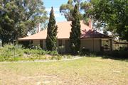
Lot 101 Homestead Rd Gosnells
City of Gosnells Museum
Orange Tree Farm Museum
Gosnells
Metropolitan
Constructed from 1912
| Type | Status | Date | Documents |
|---|---|---|---|
| State Register | Registered | 26 Feb 1999 | HCWebsite.Listing+ListingDocument, HCWebsite.Listing+ListingDocument |
| Type | Status | Date | Documents |
|---|---|---|---|
| (no listings) |
| Type | Status | Date | Grading/Management | |
|---|---|---|---|---|
| Category | ||||
| Aboriginal Heritage Sites Register | Permanent | |||
Good
| Library Id | Title | Medium | Year Of Publication |
|---|---|---|---|
| 5287 | Conservation plan for Wilkinson Homestead (Orange Tree Farm, City of Gosnells Museum) and John Okey Davis Park. | Heritage Study {Cons'n Plan} | 2001 |
Individual Building or Group
| Epoch | General | Specific |
|---|---|---|
| Present Use | EDUCATIONAL | Museum |
| Original Use | FARMING\PASTORAL | Homestead |
| Style |
|---|
| Federation Bungalow |
| Type | General | Specific |
|---|---|---|
| Roof | METAL | Corrugated Iron |
| Wall | BRICK | Common Brick |
| General | Specific |
|---|---|
| OCCUPATIONS | Rural industry & market gardening |
| DEMOGRAPHIC SETTLEMENT & MOBILITY | Settlements |
| SOCIAL & CIVIC ACTIVITIES | Cultural activities |
This information is provided voluntarily as a public service. The information provided is made available in good faith and is derived from sources believed to be reliable and accurate. However, the information is provided solely on the basis that readers will be responsible for making their own assessment of the matters discussed herein and are advised to verify all relevant representations, statements and information.
Lot 50 Canning Mills Rd Kelmscott
Address includes: Lots 51 & 52 Turner Rd, Kelmscott; Lots 400, 51 & 52 Canning Mills Rd, Roleystone; Lots 301-304 Contour Rd, Roleystone; Lot 3089 Canning Dam Rd, Ashendon. VFL. Also in City of Gosnells. The channel runs adjacent to Channel Road for 16 kms from Roleystone to Gosnells (now Martin). Registered curtilage DOES NOT include central section that runs through residential areas of Roleystone (low authenticity)
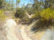
Contour Channel/Fireplaces
Two Stone Chimneys
Armadale
Metropolitan
Constructed from 1935 to 1937
| Type | Status | Date | Documents |
|---|---|---|---|
| State Register | Registered | 03 Jun 2005 | HCWebsite.Listing+ListingDocument, HCWebsite.Listing+ListingDocument |
| Type | Status | Date | Documents |
|---|---|---|---|
| (no listings) |
| Type | Status | Date | Grading/Management | |
|---|---|---|---|---|
| Category | ||||
| Municipal Inventory | Adopted | 01 Dec 2008 | Category 1 | |
| Municipal Inventory | Adopted | 01 Sep 2015 | Category 1 | |
| Classified by the National Trust | Classified | 28 Aug 1995 | ||
| Art Deco Significant Bldg Survey | Completed | 30 Jun 1994 | ||
| Aboriginal Heritage Sites Register | Recorded | |||
03830 Canning Dam
The condition of Canning Contour Channel (fmr) ranges from excellent to poor. Some sections are in good condition, with little change to the fabric since construction in 1937. However, other parts are missing or have been severely damaged through intrusion by rocks or natural bush growth from the surrounding terrain.
| Name | Type | Year From | Year To |
|---|---|---|---|
| E. W. Tindale, the Chief Engineer | Architect | - | - |
| Victor Munt and Don Munro, Resident Engineers | Architect | - | - |
| Russell (RJ) Dumas, Engineer in Charge of Construction | Architect | - | - |
| Library Id | Title | Medium | Year Of Publication |
|---|---|---|---|
| 10173 | Canning Dam: a golden era | Book | 1983 |
| 6025 | Canning contour channel : heritage assessment. | Heritage Study {Other} | 2003 |
| 10136 | Canning Dam: historical engineering marker. Unveiling ceremony 2 September 1998 | Brochure | 0 |
| 10137 | Our Dam: Canning Dam | Brochure | 1997 |
| 9984 | Perth's early water supplies. Australian Heritage Engineering Record. | Book | 1984 |
Individual Building or Group
| Epoch | General | Specific |
|---|---|---|
| Present Use | VACANT\UNUSED | Vacant\Unused |
| Original Use | GOVERNMENTAL | Other |
| Original Use | GOVERNMENTAL | Reservoir or Dam |
| Original Use | Transport\Communications | Water: Other |
| Style |
|---|
| Other Style |
| Type | General | Specific |
|---|---|---|
| Wall | STONE | Local Stone |
| Wall | CONCRETE | Other Concrete |
| General | Specific |
|---|---|
| OUTSIDE INFLUENCES | Depression & boom |
| DEMOGRAPHIC SETTLEMENT & MOBILITY | Workers {incl. Aboriginal, convict} |
| SOCIAL & CIVIC ACTIVITIES | Community services & utilities |
| OUTSIDE INFLUENCES | Water, power, major t'port routes |
This information is provided voluntarily as a public service. The information provided is made available in good faith and is derived from sources believed to be reliable and accurate. However, the information is provided solely on the basis that readers will be responsible for making their own assessment of the matters discussed herein and are advised to verify all relevant representations, statements and information.
Constructed from 1935, Constructed from 1937
The contour channels and associated structures have aesthetic value as the remains of a significant engineering construction that although man-made, sits harmoniously within the natural environment. The place is an important example of the original water transportation system and demonstrates the hard work required of the labour force during that time. The place is of significant value because of the potential of the site to contribute to the understanding of the water transportation method. The place is a rare example of a structure that was designed and constructed between 1935 & 1937 for the transportation of water. The continued use of parts of the channel as a walking path by local residents reflects its ability to interest people beyond its original function.
The contour channel comprises a series of open concrete channels connected with cast iron pipe siphons over the gullies. The channel follows the contours of the Darling Scarp between Canning Dam and Martin, and is approximately 1.5 metres wide at the base with raking sides at 45o banking up to the natural ground level. At ground level the channel is approximately 5 metres wide, with an overall depth of approximately 2 metres. Together with the channels, there are two stone chimneys and a number of associated works including stilling ponds, a flow measurement building and flume.
The Canning Contour Channel was originally a (16 kilometre long) series of water channels connected by piped sections over gullies, the only contour channel built in Western Australia for the transport of potable water. Built between 1935-37 for the Metropolitan Water Supply, Sewerage and Drainage Board, the Canning Contour Channel had a number of associated works such as the ‘stilling’ chambers and the Gosnells Screens (both 1937). The idea of an open contour water channel had first been recommended in a 1920 report, as a more economical means of conveying potable water, compared to a pipeline. In 1935, E. W. Tindale, the Director of Works for the Canning Dam construction supported this conclusion. He had seen this type of delivery system work successfully in Victoria and believed it could also work well in Western Australia. The projected cost of the Contour Channel and associated pipeline was £155,000. (The actual cost of the work was £125,000.) The Canning Contour Channel construction commenced in June 1935, under the supervision of Public Works engineers, E.H. Oldham and J.W. Allen. Until its completion in 1937, all water from the Canning Reservoir to Perth was conveyed through a 762mm pipeline from the dam to Kelmscott, and a 914mm pipeline from there to the storage reservoir at Mt Eliza in King’s Park. The pipeline to Gosnells was only a temporary measure, however. Once the rising dam wall increased the storage capacity of the partly completed reservoir and the volume of water available, the water was conveyed through the Canning Contour Channel to Gosnells, and by pipeline the rest of the way. The new contour channel followed the Canning River Valley for a distance of 16kms, to a point in the foothills above Gosnells. From there, a 1.37m pipe took the water to Cannington, where it connected with mains to Fremantle and Mt Eliza. The contour channel walls were constructed of concrete, with a base of local gravel, and were cut into the sides of the hilly terrain. In addition, a number of piped siphons were used to pass the channel water from one side of the valley to the other or to cross under existing roads. As the channel passed through thick bush and, at times, traversed extremely steep-sided valleys and gullies, access was difficult. Due to the difficult terrain, little mechanization was used in the building of the contour channel. However, light rail tracks were laid in the completed parts of the channel, to take equipment and pipes to the workface. In addition, horses and carts were used to take equipment into the areas that were not too steep. Most of the construction work was, however, carried out by workmen using the basic implements of picks, shovels and wheelbarrows, and simple pulleys, with block and tackle, were used to position the cast iron siphon pipes. The workers employed on the construction of the channel lived in camps at various places along the channel. The camps utilized tents, with few permanent built structures, except for some stone chimneys, used to dry the workers’ clothing, when required. The ‘sustenance’ workers involved in the project were drawn from the large body of unemployed men during this period of economic depression. However, many of the foremen and lead gangers were permanent Water Supply staff. In January 1937, 320 men were laid off when the channel and the pipe main were completed. Water from the Canning Dam was released into twin (parallel) ‘stilling chambers’, 200m from the dam, then passed through a flow recorder, and afterwards ran over boarded weirs into the concrete-lined open contour channel to the Gosnells screens. At this point, the water was filtered of any polluting matter, then piped to Perth. From 1954, the water was also chlorinated at the Gosnells site. The Canning Contour Channel was an integral part of the Perth water supply from the time of its completion until 1975. During the period of its operation, the maintenance of the contour channel was a daily task, for up to three gangs of workmen. Each day during the summer months, an inspector walked the full 16km length to report on its condition. If possible, problems would be dealt with on the spot. Otherwise, the location of the problem would be noted, and a team would then go in to fix any obstructions, or cracks in the concrete walls. Further maintenance work included the removal of algae, clearing vegetation from the banks on either side of the channel, and checking the stability of the land on the high side of the channel to prevent rock falls creating obstructions. From its commencement of operation, the Canning Contour Channel required constant upkeep to maintain its efficiency. For example, up to 20% of the water flowing along the channel was lost in leakage, with frequent small breaks and cracks requiring regular attention. In addition, when it rained heavily in the catchment area, dirt, bark, leaves and other matter, would pollute the water. In this case, the Gosnells Screens at the terminus of the Canning Contour Channel played an important role in cleaning the water before it entered the main pipeline to Perth. This filtering system consisted of a battery of six fine wire screens, which removed debris, including the remains of wildlife that became trapped in the swiftly flowing water of the channel. Prior to the installation of the chlorinating plant in 1954, samples of water were taken from the screening chamber weekly, and examined in the bacteriological laboratories of the Health Department. In 1950, a major disruption to Perth’s water supplies occurred, when a section of the contour channel near Araluen collapsed, and water restrictions had to be imposed on the city. Supplies were restored, by the extension of one of the existing siphons, to bypass the collapsed section of the channel. The Canning Dam was the main source for Perth’s water supply until the completion of Serpentine Dam in 1961. However, despite the vulnerability of Canning Contour Channel to malfunction, it was not until the 1973 that an alternative to this method of transporting water was introduced. At this time, the construction of a tunnel from the Canning Dam to Roleystone was commenced. In 1975, the Canning Contour Channel was decommissioned. On 17 January of that year, the newly completed Canning Tunnel was officially opened, by the Minister for Works and Housing. However, as a precaution, the Canning Contour Channel continued to be maintained in operational order, and opened to a flow of water in the summer for two years after 1975. In 2005, the Canning Contour Channel is no longer used for the transport of water, with the route now used mainly as a walking trail. There are also two stone chimneys along the route of Canning Contour Channel, the remnants of the campsites of workers on the project. The first chimney is situated 80 metres down a track from McNess Drive and 150m from the Canning Contour Channel. The track is one kilometre north of the junction between McNess Drive and the road to the north wall of the Canning Dam. The second chimney is visible from McNess Drive on the right hand side of the road whilst travelling north. The chimney is approximately 2.5kms from the junction of McNess Drive and the Canning Dam north wall road, located in a designated picnic site. There is also a third chimney located on Peet Road, 750m north of the junction of Peet Road and Brookton Hwy. It is on the left hand side of the road going north up the hill. It is clearly visible from the road as it is only about five metres from the road edge. It is opposite the junction of Mackie and Peet Roads, Roleystone. This third chimney is not included within the HCWA registered place.
Moderate High
Good
| Ref ID No | Ref Name | Ref Source | Ref Date |
|---|---|---|---|
| HCWA Assessment Documentation |
| Ref Number | Description |
|---|---|
| No.41 | MI Place No. |
| Reserve | Lot/Location | Plan/Diagram | Vol/Folio |
|---|---|---|---|
| various location |
This information is provided voluntarily as a public service. The information provided is made available in good faith and is derived from sources believed to be reliable and accurate. However, the information is provided solely on the basis that readers will be responsible for making their own assessment of the matters discussed herein and are advised to verify all relevant representations, statements and information.
Architectural accomplishment: The Contour Channel is a unique engineering scheme which uses the contours of the Darling Ranges to transport water to Perth’s water supplies. Historical Interest: The Contour Channel is part of the history of Roleystone, the Depression and the Water Board. Social Interest: The Contour Channel is a monument to the Depression Workers of the 1930s who shared a common work during hard times when employment was hard to find.
The channel followed the contours of the land through thick bush and was cut into the sides of the hills and traversed steep-sided valleys and gulleys making access very difficult. Pipe syphons were laid across the deeper valleys.
Assessment 1995 In 1935 – 37, just after the Great Depression, the 16 kilometre concrete-lined Contour Channel was constructed to convey water from Canning Dam down the Canning Valley to a point in the foothills above Gosnells. The project was used as a primary means of supplementing Perth’s service reservoirs from the Canning Dam storage. Until the Channel’s completion, water from the Canning was conveyed through a 30 inch (750mm) pipeline. Evacuation and construction of the channel required considerable ingenuity and was carried out almost entirely by hand. The backbreaking task provided work for 250 men, the majority of whom where unskilled workers receiving sustenance payments. This meant that over a siz week cycle a man would be employed for 3 ½ weeks only (for a single man)varying up to about 5 ½ weeks for married man with a large family. Those with the largest number of dependants were entitled to the most work and were stood down the least, if necessary. The men were paid only for the days they worked and had to make the payment last over any lean periods which intervened. The Channel was operational for nearly 40 years until 1975 when it was made redundant. The Channel has served as a useful walking trail for some local residents. In 1991 the WAWA requested the council commence rezoning the land from the Public Purpose Reserve to residential RF5, the zoning of the land adjacent to the reserve.
This information is provided voluntarily as a public service. The information provided is made available in good faith and is derived from sources believed to be reliable and accurate. However, the information is provided solely on the basis that readers will be responsible for making their own assessment of the matters discussed herein and are advised to verify all relevant representations, statements and information.
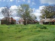
Burslem Dr Maddington
MI lists address as 14 Olga Road (122 Burslem Drive), Maddington.
Maddington Park Homestead
Gosnells
Metropolitan
Constructed from 1836
| Type | Status | Date | Documents |
|---|---|---|---|
| Heritage List | Adopted | 09 May 2017 | |
| Heritage Agreement | YES | 14 Jun 2022 | HCWebsite.Listing+ListingDocument |
| Continuing Protection Order | YES | 22 Sep 2009 | |
| State Register | Registered | 21 Sep 2001 | HCWebsite.Listing+ListingDocument, HCWebsite.Listing+ListingDocument |
| Type | Status | Date | Documents |
|---|---|---|---|
| (no listings) |
| Type | Status | Date | Grading/Management | |
|---|---|---|---|---|
| Category | ||||
| Municipal Inventory | Adopted | 13 Sep 2016 | Category 1 | |
| Register of the National Estate | Permanent | 21 Mar 1978 | ||
| Classified by the National Trust | Classified | 01 Dec 1969 | ||
Historical Society advised: Gutted by fire Foundation Day weekend 2004. Outbuildings have suffered considerably from pillage and neglect.
| Library Id | Title | Medium | Year Of Publication |
|---|---|---|---|
| 7087 | Maddington Park, Maddington : conservation plan. | Heritage Study {Cons'n Plan} | 2004 |
| 7615 | Lots 173-177 Burslem Drive Maddington : Subdivision Application. DRAFT | Heritage Study {Other} | 2005 |
| 9546 | Elsie: her life, letters and love. | Book | 1999 |
Individual Building or Group
| Epoch | General | Specific |
|---|---|---|
| Present Use | FARMING\PASTORAL | Homestead |
| Other Use | VACANT\UNUSED | Vacant\Unused |
| Original Use | RESIDENTIAL | Two storey residence |
| Original Use | FARMING\PASTORAL | Homestead |
| Style |
|---|
| Victorian Georgian |
| Type | General | Specific |
|---|---|---|
| Wall | TIMBER | Slab |
| Roof | TIMBER | Shingle |
| Wall | EARTH | Adobe {Mud Brick} |
| Roof | METAL | Corrugated Iron |
| Wall | EARTH | Wattle and Daub |
| General | Specific |
|---|---|
| DEMOGRAPHIC SETTLEMENT & MOBILITY | Settlements |
| PEOPLE | Early settlers |
| OCCUPATIONS | Rural industry & market gardening |
This information is provided voluntarily as a public service. The information provided is made available in good faith and is derived from sources believed to be reliable and accurate. However, the information is provided solely on the basis that readers will be responsible for making their own assessment of the matters discussed herein and are advised to verify all relevant representations, statements and information.
Maddington Homestead's historical attachments alone make it significant and worthy of' classification. Since before 1833 it-has been-a successful farm, making it one of the oldest in the state. It also has associations with J. Septimus Roe.
The house is apparently built of two paces of stone and now has a white plaster and a corrugated iron roof. It is set on a raised foundation and is- surrounded by a neatly-kept lawn which in turn is· enclosed · by a.hedge,_the general impression is of neatness and a seemingly well-preserved building.
Assessment 1973 Construction prior to 1833 ORIGINAL OWNER J.R. Phillips. The actualdate Phillips · acquired the property is not known but "Maddington Park" was transferred from him to a Major Wm. Nairne in 1833. Ref::"State & Position of W.A (Irwin)says "subsequently, the estate of which he (Nairne) is now in possession came into the market; finding the land was excellent and had been much improved by its owner ,Mr. J. R. Phillips who ·had also built on it a good house and office he purchased the whole, including some stock for upwards of £2,000 and commenced farming with vigour•••••••II Leased to J .Harris,Jnr. by the Estate of J.S .Roe -3,280 acres cleared and well improved with good double stone dwelling house,barn, etc. According to a Mr.S. Bishop (Accessions,State Library) a relative of his, Mr.Phillip White, lived on the farm before the Harris family. Set in an orange orchard at the end of Olga Road, the house is white plastered with corrugated iron roof. Set on raised foundation surrounded by well kept lawn and enclosed by a hedge - general impression of neat ness and seemingly well preserved. Open beams in front room replaced by plaster ceiling. One of the oldest properties in State having been built Before 1836. Taken over by James Roe, and leased .in 1879 to J .Harris Jnr.by the Estate of J.S.Roe.
This information is provided voluntarily as a public service. The information provided is made available in good faith and is derived from sources believed to be reliable and accurate. However, the information is provided solely on the basis that readers will be responsible for making their own assessment of the matters discussed herein and are advised to verify all relevant representations, statements and information.
Constructed from 1836
Maddington Homestead, a two-storey Georgian style stone house with a corrugated iron roof, a detached kitchen and dairy, a wattle and daub tack room and machinery sheds, has cultural heritage significance for the following reasons: The place is an extremely rare example of a substantial settler's house constructed in Western Australia prior to the convict era; The place is the oldest extant residence in the district and is highly valued by the community The place contributes to the community's sense of place by providing a link with the colonial development of the area The place is associated with prominent figures in the history of Western Australia and the Canning district such as John Randall Phillips, Major William Nairn, Surveyor General John Septimus Roe, Richard and Jabez White, John Liddelow and Joseph Harris and his descendants The place is associated with the earliest phases of rural development along the Canning River and with a subsequent market gardening enterprise The place illustrates the innovative and creative use of local materials to imitate those used for houses in England at the time.
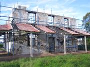
Maddington Park Homestead is in a state of ruin. The two storey house has no roof and has lost many of its walls and is now supported by scaffolding. The verandah still retains part of its corrugated iron canopy though much has been removed. Many of the battens remain in situ. The peripheral verandah is supported on square timber columns and is open with no balustrade. Due to the ruinous state of the building, it is now becoming difficult to read the place as it was designed. The fire place and prominent chimney still remain extant. The outbuildings have been retained with a small rendered brick and iron former kitchen to the north west and a wattle and daub dairy with a long open sided shed to the south west of the house. The weatherboards from the shed have been removed to the majority of the shed but evidence of retained boards can be found on the northern side of the structure. Much of the roof structure and corrugated iron cladding of the dairy remains in place though in a rusted condition. Maddington Park bounds the Canning River where the common Flooded Gums (Eucalyptus rudis) have flourished and are particularly dense. Mature trees exist in the parkland setting and extend down to the river banks. The site forms part of the Canning River environment and creates an important setting to the State Registered former Homestead.
Maddington Homestead was first settled by John Randall Phillips in 1830. Phillips chose the land along with 'Stoke Farm'. Both properties proved to have very good farming prospects. In 1833 Phillips sold Maddington Park to William Nairn, an Infantry Major. When Nairn took over the riverside property Phillips had already cleared a good amount of the land and had built a house, shed and office. Nairn became an efficient farmer and a reputable sheep breeder. Nairn had a new house, the Maddington Park Homestead, constructed. Building began c.1836 but took a number of years to complete owing to the difficulty of obtaining materials, finding craftsmen, transport and ever increasing costs. By 1840, the ground floor was only just completed. It was said that, in the end, Nairn's dream was a compulsion that wore him down. Maddington Park was the scene of early conflict between the Aboriginal people and European settlers. In 1837, two shepherds, boys of nine and eleven years, set out with Nairn's sheep to distant pastures. An altercation with two Aboriginal men led to both boys being speared. Though both recovered from their injuries, many settlers were outraged and demanded the capture of Buoyen, one of the Aboriginals involved. He was caught and brought to Maddington Park for identification by Charles Hokin, one of the shepherds. Buoyen was subsequently tried and sent to Rottnest Island for life. In 1843, Nairn mortgaged the property to Surveyor General J. S. Roe, whose family took possession of the property in 1847. It was leased and worked by a variety of people including Jabez White, John Liddelow and Joseph Harris. A 'To Let' advertisement in the Perth Gazette of 8 February 1856 described Maddington Park as: 3280 acres, extensively cleared and improved with good double stone dwelling house, large barn, stable and other buildings, cattle and cart sheds, sheep yard, garden and field enclosures and about 150 acres in and partly under cultivation. The many excellent and varied qualities of this fine estate are too well known to require comment. In 1910, the Harris family took ownership, and occupied and operated the orchard. In 1983, a fire damaged the sitting room. At the time 81-year-old Miss Amy Harris lived there. After the fire the place was then boarded up and left unoccupied. In 2001, when the Homestead was entered on the State Register of Heritage Places, it was described as being in sound condition but in need of renovation. At the time, the property was described as: [A] two-storey stone residence, nine rooms in all and a cellar. Adjacent is a wattle and daub tack room, a detached kitchen and dairy, and two corrugated iron sheds. The site is surrounded by 150 acres (60.75ha) of established market garden and orchard. A 2004 conservation report by Blackwell & Associates noted that: 'two large post mature Schinus molle - Pepper Trees flank the garden path to the north/east boundary. The trees are significant and would appear to have been planted in the early stages of the garden development'. In 2003, Maddington Park was acquired by new owners. On 6 June 2004, the Homestead was gutted by fire and on 1 March 2005, another fire destroyed several of the trees at the rear of the buildings, charred the dairy, and damaged the Pepper Trees. The current owners have subdivided the land adjoining the Homestead buildings and are considering the options for the Homestead, as part of the redevelopment of the site.
Integrity: Low Authenticity: Moderate
Very poor (ruinous)
| Ref ID No | Ref Name | Ref Source | Ref Date |
|---|---|---|---|
| McDonald & Cooper;"The Gosnells Story". | 1988 | ||
| Heritage Council P1132; " Maddington Homestead". | |||
| Notes from the McNamara’s File |
| Owner | Category |
|---|---|
| Wellington Parkland Pty Ltd | Other Private |
This information is provided voluntarily as a public service. The information provided is made available in good faith and is derived from sources believed to be reliable and accurate. However, the information is provided solely on the basis that readers will be responsible for making their own assessment of the matters discussed herein and are advised to verify all relevant representations, statements and information.