Local Government
Irwin
Region
Midwest

Cnr Brand Hwy & Bookara East Rd Bookara
Irwin
Midwest
Constructed from 1905
| Type | Status | Date | Documents |
|---|---|---|---|
| State Register | Registered | 16 Dec 2003 | HCWebsite.Listing+ListingDocument, HCWebsite.Listing+ListingDocument |
| Type | Status | Date | Documents |
|---|---|---|---|
| (no listings) |
| Type | Status | Date | Grading/Management | |
|---|---|---|---|---|
| Category | ||||
| Municipal Inventory | Adopted | 10 Mar 1998 | Category 1 A | |
| Register of the National Estate | Indicative Place | |||
| Classified by the National Trust | Classified | 10 Oct 1983 | ||
| Register of the National Estate | Nominated | 30 May 1984 | ||
| Library Id | Title | Medium | Year Of Publication |
|---|---|---|---|
| 5253 | Former Seventh Day Adventist Church building, Bookara, Western Australia : conservation plan / Eastman and Poletti Architects. | Heritage Study {Cons'n Plan} | 2002 |
Individual Building or Group
| Epoch | General | Specific |
|---|---|---|
| Present Use | VACANT\UNUSED | Vacant\Unused |
| Other Use | EDUCATIONAL | Combined School |
| Original Use | RELIGIOUS | Church, Cathedral or Chapel |
| Style |
|---|
| Victorian Georgian |
| Type | General | Specific |
|---|---|---|
| Roof | METAL | Corrugated Iron |
| Wall | STONE | Local Stone |
| General | Specific |
|---|---|
| SOCIAL & CIVIC ACTIVITIES | Education & science |
| SOCIAL & CIVIC ACTIVITIES | Religion |
This information is provided voluntarily as a public service. The information provided is made available in good faith and is derived from sources believed to be reliable and accurate. However, the information is provided solely on the basis that readers will be responsible for making their own assessment of the matters discussed herein and are advised to verify all relevant representations, statements and information.
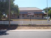
An early church of indigenous architectural character - small, simple, built of stone and corrugated iron; surviving from the original settlement at Bookara. The former church, no longer in use, and the ruins of the travellers Rest Inn opposite constitute the remains of the settlement.
Stone walls, CGI roof. A simple rectangular stone church with pitched corrugated iron roof and later timber porch entrance positioned to protect the door at the front.
Assessment 1984 Construction c. 1860's Possibly Methodist originally. The settlement of Bookara was established where the road between Irwin and the Greenough Front Flats met the inland road to the east.
This information is provided voluntarily as a public service. The information provided is made available in good faith and is derived from sources believed to be reliable and accurate. However, the information is provided solely on the basis that readers will be responsible for making their own assessment of the matters discussed herein and are advised to verify all relevant representations, statements and information.
Constructed from 1941, Constructed from 1905
Seventh Day Adventist Church (fmr), constructed in locally quarried stone and corrugated iron in the Victorian Georgian style, is of cultural heritage significance for the following reasons: notwithstanding its derelict state, the place was the first Seventh Day Adventist church to be constructed in Western Australia; the place is one of the remaining components of the historic Bookara locality, marking the southern edge of the Greenough Flats historic precinct, and together with the other buildings of the area characterised by similar building materials and forms, collectively forms a significant cultural landscape; the construction of the place in 1905 reflected the high local concentration of Seventh Day Adventists, the strong influence of their faith in the Bookara community, and their optimism in the future of their church for what was, at the time, not a widely practiced denomination within Western Australia; the construction of the place in 1905 and its later vestibule addition in1941 reflected the continuing prosperity of the Bookara region and the continuing importance of the place within the community. Its closure in 1956 is a reflection of the decline of the small rural community of Bookara; and the place has a strong association with many of the pioneering families within the wider Greenough region, including the Hollingsworth, Edwards and Stokes families, who were the founding members of the Seventh Day Adventist congregation in the Bookara region.
This simple church built in the Victorian-Georgian style has a high pitched corrugated iron gable roof with a small timber frame and asbestos clad porch to the west end of the building which has a roof of the same pitch. The church walls are of random rubble limestone construction with pointed stone to the west end. Entry to the church is via four concrete steps to double timber entry doors set in the north side of the porch. The main building has a timber floor and two tall pivot windows to each side. There is evidence of an entry door and lintel to the east wall which has been filled in with stone. 23 March 2004 The building has deteriorated since the last inspection in 1997, part of the roof is missing, the asbestos cladding on the porch has been destroyed.
This small church is the first Seventh Day Adventist Church opened in Western Australia. The building is situated half way between Greenough and Dongara on the corner of the Greenough - Dongara Road and the road east to the old North Road, directly opposite the Bookara Inn (former Traveller's Rest, Place No. 1). The stone and the land for the building was donated by the Hollingsworth family in 1903. The church was built by Jack Tetlow and the roof was put on by Mr Symonds who later married Eliza Hollingsworth. The Former Seventh Day Adventist Church, Bookara was commenced in 1905 with construction carried out by William Tetlow with assistance from his brother Arthur Tetlow and English builder Archibald Corker and his offsider Harry Symonds. It is believed that Harry Symonds, who later married Eliza Hollingsworth, was the roofer. On Saturday, 6th March 1905, the newly built Bookara Church was dedicated by Pastor L. Finster. The following day, on 7th March 1905, Pastor Finster organized the Bookara Seventh Day Adventist Company into a church. On that day twelve persons were voted in as foundation members. They were: Richard and Mary Hollingsworth; Margaret Anne Edwards (Senior); George and Hollingsworth; Eliza Jane Hollingsworth; Harry Symonds; Archibald and Rose Ann Corker; George and Rose Ann Edwards; Arthur Edwards; Edward John Edwards and Thomas A Hollingsworth. A Seventh Day Adventist primary school was started at the Bookara Church in 1908 and ran until 1915 when it was closed. Miss Markey was sent to open the church school at Bookara. She was followed by Miss Robinson . In 1909 E. Hollingsworth was granted a Missionary Teacher’s License. The vestibule (porch) was added in 1941. The use of the church for worship ceased in 1956 and the building has remained unused and unoccupied since. Victoria Location 738, including the former Traveller’s Rest Inn building, the former Seventh Day Adventist church and other buildings, was purchased by Mr. Malcolm Mackenzie in December 1965. The next owner of the property was J.A. Teasdale who purchased the land in February 1977 and sold it to Mr. Albert Henry Lenane in 1979 . Mr. Lenane subdivided the property in 1996 and an 11.7179 hectare block, on which the church occupied a small area in the northwest corner, became Lot 16, located at the corner of East Bookara Road and Brand Highway . Mr. Christopher Zalmstra and Mrs. Jennifer Zalmstra placed an offer and acceptance on the property through Kalazich Smith Real Estate, agents acting on behalf of Cababindi Nominees Pty Ltd A.C.N. 008 830 635 and Mr. Albert Lenane, on 21 April, 1997. The sale was subject to clarification of ownership of the old church situated on the property and was to form part of the sale. This process was time consuming and laborious for the vendor, but was achieved and settlement occurred on the 16 June, 1998. The current owners have a conservation plan and the place was entered into the State Register of Heritage Places on 16 December 2003 (on a permanent basis). In April 2004 the owners received a federally funded heritage conservation grant and plan to repair the stonework and reroof the building. (Source: IDHS records, letter from Seventh Day Adventist Church, Perth, HCWA Database, email from J. Zalmstra, Bookara Seventh Day Adventist Church Conservation Plan)
Integrity: High Original Fabric: Mostly intact Modifications: Minor
Poor
| Ref ID No | Ref Name | Ref Source | Ref Date |
|---|---|---|---|
| IDHS Records | |||
| AHC Reference 009671 01-02, | 30/5/1984 | ||
| B Sherwood, Eastman, Polletti, Sherwood Architects; "Bookara Seventh day Adventist Church Conservation Plan". | |||
| HCWA Database No.1240 |
| Owner | Category |
|---|---|
| CB & JM Zalmstra | Other Private |
This information is provided voluntarily as a public service. The information provided is made available in good faith and is derived from sources believed to be reliable and accurate. However, the information is provided solely on the basis that readers will be responsible for making their own assessment of the matters discussed herein and are advised to verify all relevant representations, statements and information.

Brand Hwy 3 km E of townsite Dongara
Incs. blacksmith's shop, farmhouse, cottage, store, other assoc bldgs & structures & gardens.
Osborn's, Rowland's, Mason's, Ridley's
Irwin
Midwest
Constructed from 1868 to 1891
| Type | Status | Date | Documents |
|---|---|---|---|
| State Register | Registered | 24 Nov 2000 | HCWebsite.Listing+ListingDocument, HCWebsite.Listing+ListingDocument |
| Type | Status | Date | Documents |
|---|---|---|---|
| (no listings) |
| Type | Status | Date | Grading/Management | |
|---|---|---|---|---|
| Category | ||||
| Classified by the National Trust | Classified | 02 Apr 1984 | ||
| Register of the National Estate | Nominated | 30 May 1984 | ||
| Register of the National Estate | Indicative Place | |||
| Municipal Inventory | Adopted | 10 Mar 1998 | Category 1 A | |
Good
| Name | Type | Year From | Year To |
|---|---|---|---|
| The Pell Family | Architect | - | - |
| Library Id | Title | Medium | Year Of Publication |
|---|---|---|---|
| 7770 | Old east end, Dongara, Western Australia: conservation plan. | Heritage Study {Cons'n Plan} | 2005 |
Individual Building or Group
| Epoch | General | Specific |
|---|---|---|
| Original Use | FARMING\PASTORAL | Homestead |
| Other Use | FARMING\PASTORAL | Blacksmith's Shop |
| Present Use | FARMING\PASTORAL | Cottage |
| Present Use | COMMERCIAL | Hotel, Tavern or Inn |
| Original Use | COMMERCIAL | Shop\Retail Store {single} |
| Other Use | FARMING\PASTORAL | Shed or Barn |
| Style |
|---|
| Victorian Georgian |
| Type | General | Specific |
|---|---|---|
| Roof | METAL | Corrugated Iron |
| Other | EARTH | Other Earth |
| Other | TIMBER | Tongue & Groove |
| Wall | STONE | Limestone |
| General | Specific |
|---|---|
| PEOPLE | Early settlers |
| OCCUPATIONS | Commercial & service industries |
| DEMOGRAPHIC SETTLEMENT & MOBILITY | Land allocation & subdivision |
This information is provided voluntarily as a public service. The information provided is made available in good faith and is derived from sources believed to be reliable and accurate. However, the information is provided solely on the basis that readers will be responsible for making their own assessment of the matters discussed herein and are advised to verify all relevant representations, statements and information.
Constructed from 1868
The four stone buildings comprising the Old East End have high historic significance given their connection with the early settlement of the Irwin District and their connection to the Osborn, Pell and Rowland families. The careful restoration of the buildings coupled with their setting gives the place an authentic sense of the past. In addition the prominent position of the buildings on Brand Highway adds to the character of the East End of Dongara.
OLD EAST END This is a group of four stone buildings, a corrugated iron shearing shed (reconstructed), and an open pole wagon shed (reconstructed). The stone buildings front directly on to Brand Highway and are situated about three kilometres east of the Dongara townsite. The buildings have been restored from a ruinous state between 1984 and 1992 are set in gardens with separate fenced areas which follow lot divisions. THE STORE Lot 1 Vic Loc 914 The building is set on a 1/8th of an acre lot close to the highway, with the verandah forming the road frontage. The building is of high volume with a hipped corrugated iron roof and a separate hipped verandah roof to the front (south) supported on timber posts with a concrete verandah floor. A large corbelled stone chimney punctuates the northeast aspect of the main roof. The main section is a single room some 10m by 6m with a timber ceiling set at 4m height. Interior walls of the main section are whitewashed. The front windows are large, timber framed and arched design. Set between them are double timber entry doors with an arched fanlight above. The front exterior of the building is white washed with painted quoining to the openings and corners, while a picket fence with a central picket gate runs between the verandah posts. To the rear, a large hipped skillion roof covers an area some 4m by 10m. which is of timber frame construction with CGI cladding and a pressed metal interior and ceiling. The timber windows of the frame section are awning style, a central timber plank door affords rear entry, a third entry door is situated in the centre of the main east wall. The entire lot is surrounded by a 1500mm gothic style picket fence with a centrally placed matching picket gate to the rear. FANNY'S COTTAGE Lot 2 This is a small four room stone cottage, set back some 4m from the highway. A hipped corrugated iron roof extends to cover the front (south) verandah which has a timber floor and is supported on disappearing chamfer timber posts. The verandah has timber cladding with scalloped boards to each end. There is a small stone chimney to the west elevation. There is a skillion roof to the rear which covers the two rear rooms, this also extends to the north-west to cover a small timber framed cream painted corrugated iron clad addition which serves as a bathroom. There is a central front door with double hung windows each side. Other windows are small paned and casement style. There are two rear entry doors, one placed centrally and the other close to the CGI addition. Interiorly there are no ceilings and original joinery and cupboards are intact in the sitting room. A 1m high gothic style picket fence forms the front boundary of the cottage. GERTIES FARMHOUSE Lot 21 Set back some 3m from the highway, this stone house with a steeply pitched corrugated iron gable roof which extends to cover the front (south) verandah which has a timber floor and is supported on disappearing chamfered timber posts. There is a lean-to roof to the rear with a verandah beyond and to the west. The front windows are timber framed and double hung, the rear are small, timber framed, four paned and centrally pivoted. The west verandah is enclosed with glass behind large trellis panels, the rear verandah has two large sliding glass doors with double doors between. The north east end of the rear verandah has been enclosed with cream painted corrugated iron. A 1500mm gothic style picket fence forms the front (south) and west boundary. BLACKSMITH'S SHOP Lot 21 Sited close to the south west corner of the property under a large Tuart Tree (eucalyptus gomphocephala) the Blacksmith's shop has a gable corrugated iron roof which covers the three main rooms and a lean-to to the north. The central main room, west room and lean-to are constructed of random rubble limestone. The central room and lean-to to the north house the blacksmith's forge and bellows respectively. The room to the east of the central room has timber framed and clad walls. There are two sets of double doors located in the south facade which give access to the central and west room. A small stone chimney is located at the apex of the gable of the north wall. Two sets of four paned windows are located to the east, south and north facades of the main building and to the north facade of the lean-to. Access from the rear is via a timber door to the east room. Located about half a metre of the northwest corner of the building is a 10,000 gallon (50,000 litres) stone and concrete lined under ground tank. A hipped corrugated iron roof covers the tank with timber access doors located to the north east.
EAST END HISTORY BY JOHN ROWLAND The property known as Old East End is situated on five separate lots on Victoria Location 914 which was an original Crown Grant of 9 3/4 acres made to Charles Vinier on 26 March 1878, " ..in consideration of the sum of five pounds twelve shillings and sixpence sterling". In June 1881, almost 4 acres were sold to the Osborn family, and in December 1890, 1/8th of an acre was sold to Mary Ridley. The Midland Railway Company officially took title to a resumed strip of land through the property in November 1892, and a further 1/8th of an acre was sold to Henry Looke in January 1893. The balance of Location 914, now 5 and 1/4 acres was mortgaged to Francis Pearse, merchant, in June 1900 to secure a debt of £596/14/0. On the 30 July 1904, Charles Vinier lost the final remnant of his land when the Sheriff of Western Australia transferred it to Francis Pearse under writ of Fi Fa .[1] When Vinier purchased the land in 1878, his intentions were unknown, but he did have a sitting tenant, namely William (Willie) Osborn, who, along with his wife Sarah and family, had squatted on Loc 914 in 1868 in anticipation of being able to purchase it. [2] William and Sarah had arrived in the Swan Colony in 1850. He was a blacksmith and farrier, she a seamstress, midwife and nurse.[3] William worked for a short while as blacksmith and builder at the Fremantle Gaol, and then became an employee of Major Logue as blacksmith and shepherd at his property 'Ellendale' at the Greenough, where it is recorded that he drew stores on 25 August 1853. [4]. In 1854, William Osborn is thought to have accompanied the Austin survey party into the Murchison at which time he developed an interest in mapping. In 1868, he hand drew a map of the Lower Irwin District and identified all the land owners on it.[5] By 1862, William and Sarah were employed by Lockier Burges of the 'Cattle Company' at Toodyay, transferring to the company's property 'Irwin House' in about 1866. In 1868, William Osborn successfully tendered for a three year mail contract between Perth and Northampton, with a tender price of £280 per annum. [6] It was at this time that his family squatted on Location 914, a suitable tillage lease of almost 10 acres on the main road between Dongara and Irwin some two miles east of the Dongara townsite. They constructed a two room cottage of local limestone with river mud as mortar. With the help of his eldest son, William (jnr), the postal contract was fulfilled while William (snr) and his youngest son Charles built a substantial blacksmith's shop on the property. [7] It fronted the main road and had twin forges and had a carriage room, livery room, separate room for the two bellows, as well as the main central blacksmith room. It was constructed of local limestone with river sand and lime mortar. Operation of the blacksmith's shop was recorded by Police Constable Stack when the police horse 'High Flyer' was shod by William Osborn in 1870.[8] During 1870-75, the main four room farmhouse (with central passage) was constructed. It was sited between the two room cottage and the blacksmith's shop.[9] With all these substantial improvements to Location 914, Osborn still did not own the land. As mentioned above, the land was eventually purchased by Vinier in 1878, with subdivision in 1881 when Osborn purchased four acres including all improvements on Lot 21 Location 914. In 1890, the 1/8th of an acre sold to Ridley became Lot 1. Henry Ridley was an engineer for the Midland Railway Company, and Lot 1 was purchased for his wife, Mary. This small lot had main road frontage and adjoined the east boundary of Osborn's four acres. Mary Ridley had a large single roomed stone building constructed on her lot with a timber frame and corrugated iron clad skillion at the rear. The building was intended for use as a shop and fronted directly on to the road reserve.[10] The land resumed for the right of way of the Midland Railway in 1892, bisected Location 914. Not only did the balance of Vinier's land get cut in half, but Osborn's four acres suffered the same fate. This resulted in twin pairs of gates being constructed by the Midland Railway company so that Vinier and Osborn could have independent access to their land on the opposite side of the railway line. The last subdivision by Vinier was in 1893 which was designated as Lot 0 Location 914. It was sold to Henry Looke. It adjoined the east boundary of Mary Ridley's lot and like hers had main road frontage. Vinier's last piece of land was transferred to Francis Pearse by the Sheriff of Western Australia in 1904 was Lot 19 Location 914. The Osborn family continued to make improvements of Lot 21 and in 1894 expanded the original tworoom cottage to four. This addition of two stone walled rooms was the first independent building work done by the young Charles Osborn, who had taken over the blacksmithing business following the death of his father in the same year. [11] In 1895 Charles Osborn married Eliza Pell, the seventh child of John and Esther Pell. They came from the village of Wimpole in Cambridgeshire and had arrived in Western Australia on the 'Sophia' in 1850. John Pell commenced work in Toodyay was employed by Gerald de Courcey Lefroy at his property 'Walebing' as a farm hand and shepherd. John and Esther's first child, George, was born on 15 November 1850 and was the first European child born in the Victoria Plains.[13] The Pell's had thirteen children, nine daughters and four sons. Three of their children George, Frances (Fanny) and Eliza were all connected in some way to the 'East End'. Following employment with Lefroy, John Pell worked for 'Squire' Samuel Phillips at 'Culham', Toodyay. Phillips was a partner in the Cattle Company along with Burges, Hamersley and Vigors and John Pell transferred to work at the Company's property in the Irwin District.[14] John and Esther's son George married Elizabeth Brown and they had six children. Their fifth child and first daughter was Gertrude, born on 15 August 1892. Gertrude's father died in 1894 and following the marriage of Aunt Eliza to Charles Osborn in 1895, she was fostered by them at the East End. Meanwhile another aunt of Gertrude, and Eliza's sister, Frances (Fanny) Cousins (nee Pell) was given tenancy of the original cottage at the East End, along with her seven children.[15] Gertrude continued to live with Eliza and Charles Osborn, with Charles doing less blacksmithing and more building work. Finally in 1900 the blacksmithing business was closed and Charles became a full time builder in the district. By 1912, Charles had purchased various lots on Location 318 which adjoins Location 914, and built a new home on the steep banks of the Irwin River. In the same year, Gertrude Pell, now 19, married Silas Rowland who had purchased Lot 21 from Charles Osborn in 1910. They carried out major renovations to the house. New verandahs were added, pressed metal ceilings installed, chimneys moved and rebuilt and shingle roofs replaced with corrugated iron. Silas Rowland was a grandson of Richard and Elizabeth Rowland who arrived in Western Australia from Yorkshire aboard the 'Tranby' in February 1830. The vessel had been chartered by John and Joseph Hardy and Michael and James Clarkson. Richard and Elizabeth, who were indentured servants to the Clarkson family, were married on the 'Tranby' during the voyage from England. [16] In 1917, Silas Rowland was killed in action during World War I, leaving Gertrude with two small sons. She decided to subdivide Lot 21, retaining the main house and blacksmith's shop as a farm shed and selling off the smaller original cottage. The subdivided portion was classified as Lot 2 Location 914 and was sold to Annie Mason in 1919. Annie also purchased Lot 19 from Francis Pearse. She lived in the cottage until 1951 when she sold it to Gertrude's brother, Charles Pell. Charles passed away in 1952 and left the property to his nephew John Rowland (a minor). John was Gertrude's grandson and was fostered by his grandmother following the break up of his parent's marriage in 1945. All the buildings at the East End had little maintenance from about 1925 onwards. Mrs Ridley's shop had not been a success and she sold it to the storekeeper Francis McCoo in 1892 who sold it to the Hon. Sir Edward Wittenoom in1902. In 1914 it was transferred to Samuel Joseph Fortescue Moore. Following Moore's death, his estate sold the property to Charles Sloper in 1924 and then to the storekeeper Rur Singh of Afghan descent in 1935. Following Rur's death it was purchased by Frederick and Nellie Windsor in 1950, Dorothy Fabling purchased the lot in 1953. The adjoining 1/4 acre Lot 0 was sold to Henry Looke in 1893 and purchased in 1975 by Robert fabling for undischarged rates. In 1989 both Lot 1 and Lot 0 were sold to John Rowland and Graham Grundy, thus returning all the lots of Old East End to a single owner. Gertrude Rowland continued to live in the main house on Lot 21 until 1976 when at the age of 84 she built a new bungalow home on a lot on the opposite side of the main road. Domestic animals, such as ducks and fowls were left at the old house and she tended them night and morning. The East End buildings continued to deteriorate. Mary Ridley's shop had been ravaged by fire in 1962. The original cottage was used as a stable for horses which resulted in large sections of wall being pushed down. The blacksmith shop also lost some of its walls and roof due to the pressure of overhanging tree branches. The main farmhouse suffered substantial damage to its verandahs when trees feel on to them. All buildings suffered extensive damage to timber components due to rot and termites. In 1982, John Rowland returned to the district and in 1987, in partnership with Graham Grundy, decided to try and salvage the buildings and grounds to something of their former stature. The memories of John were used in this restoration as was the vivid memory of Gertrude Rowland who lived to be 99 years old and passed away in 1991 just before the project was completed. Mary Ridley's shop was purchased from Doris Fabling in 1990, and the shop restored, while the relocation of the railway line around the property saw the return of this strip of land, originally resumed in 1892. In 1996, the complex was awarded the Western Australia Civic Design Award for Heritage Restoration. "Old East End", as the complex is now known, takes its name from the old postal address. Up to the early 1960s it was known as the East End, Dongarra. While the lots still remain as separate titles, the entire location 914 has returned to single ownership. [1] Grant No.4484 and Certificate of title Vol 3 Fol 362 [2] Personal memories of Eliza Osborn (nee Pell) 1865-1959 [3] Erickson, R., "Dictionary of WA" [4] Bain, M.A., "Ancient Landmarks", UWA Press, 1975 [5] Conserved map, held by the IDRS, gift from the Osborn family [6] Bain, M.A., "Ancient Landmarks", UWA Press, 1975 [7] Personal memories of Eliza Osborn (nee Pell) 1865-1959 [8] Dongarra Occurrence Book, P. C. Stack, 1870 [9] Personal memories of Eliza Osborn (nee Pell) 1865-1959 [10] Personal memories of Eliza Osborn (nee Pell) 1865-1959 [11] Personal memories of Eliza Osborn (nee Pell) 1865-1959 [12] Erickson, R., "Dictionary of WA' [13] Pell Family Tree [14] Personal memories of Gertrude Rowland (nee Pell) 1892-1991 [15] Personal memories of Gertrude Rowland (nee Pell) 1892-1991 [16] Johnson, George, Personal diary of 'Tranby' Voyage to WA, 1839
Integrity: High
Good
| Ref ID No | Ref Name | Ref Source | Ref Date |
|---|---|---|---|
| JV Rowlands; "Family Records". | |||
| IDHS Records | Shire of Irwin | ||
| AHC Reference 009675 01-02 | Australian Heritage Council | ||
| MA Bain; "Ancient Landmarks". | UWA Press | 1975 | |
| PC Stack; "Dongara Occurance Book". | 1870 | ||
| HCWA Database No. 1217 | State Heritage Office | ||
| R Erikson; "Dictionary of WA". |
| Owner | Category |
|---|---|
| J.V. Rowland & G. W. Grundy | Other Private |
This information is provided voluntarily as a public service. The information provided is made available in good faith and is derived from sources believed to be reliable and accurate. However, the information is provided solely on the basis that readers will be responsible for making their own assessment of the matters discussed herein and are advised to verify all relevant representations, statements and information.

Moreton Tce & Point Leander Dv Dongara
From Waldeck to Martin Streets
Irwin
Midwest
Constructed from 1906
| Type | Status | Date | Documents |
|---|---|---|---|
| State Register | Registered | 27 Feb 2004 | HCWebsite.Listing+ListingDocument, HCWebsite.Listing+ListingDocument |
| Type | Status | Date | Documents |
|---|---|---|---|
| (no listings) |
| Type | Status | Date | Grading/Management | |
|---|---|---|---|---|
| Category | ||||
| Classified by the National Trust | Classified {Trees} | |||
| Aboriginal Heritage Sites Register | Permanent | |||
| Register of the National Estate | Registered | 14 May 1991 | ||
| Aboriginal Heritage Sites Register | Interim | |||
| Municipal Inventory | Adopted | 16 Oct 1996 | Category 1 A | |
Good
| Library Id | Title | Medium | Year Of Publication |
|---|---|---|---|
| 6607 | Register of significant trees as at June 1988. | Report | 1988 |
Tree
| Epoch | General | Specific |
|---|---|---|
| Original Use | SOCIAL\RECREATIONAL | Other |
| Present Use | SOCIAL\RECREATIONAL | Other |
| General | Specific |
|---|---|
| SOCIAL & CIVIC ACTIVITIES | Community services & utilities |
| SOCIAL & CIVIC ACTIVITIES | Environmental awareness |
This information is provided voluntarily as a public service. The information provided is made available in good faith and is derived from sources believed to be reliable and accurate. However, the information is provided solely on the basis that readers will be responsible for making their own assessment of the matters discussed herein and are advised to verify all relevant representations, statements and information.
Constructed from 1906
18626 Dongara Townsite
Moreton Terrace & Point Leander Drive Fig Trees, Dongara, consisting of street plantings of Moreton Bay (Ficus macrophylla) and Point Jackson (Ficus rubiginosa) Fig Trees, has cultural heritage significance for the following reasons: the trees were planted in the main street of Dongara in 1906 and form a rare, extant example of the 'City Beautiful' philosophy that was current at the time in Western Australia, demonstrating a desire by the Irwin Roads Board to enhance the status and amenity of the town; the trees are an uncommon landscape arrangement in Western Australia, where large Ficus trees rarely form the principal street planting, exhibiting a large deeply furrowed form of the tree trunks creates a visually impressive avenue; the trees form an impressive and significant element in the historic streetscape and townscape character of Dongara; and, the trees are valued by the community as shown by the recent planting of replacement trees, ensuring continuity over time of the central focus for the town. Other elements within the curtilage, including kerbing and street paving, are of little significance.
Large spreading Moreton Bay Fig (ficus macrophylla) and Port Jackson Fig (ficus robinosa) trees line the main street of Dongara. Formerly Main Street, but renamed Moreton Terrace, it connects the historic precinct around the intersection of Waldeck Street to the Brand Highway intersection. The large root structures and spreading shady canopies are a striking feature. Trimming of the trees has been done to remove some lower branches as well as some of the central structure of the trees on the north side of the street which have power lines running through them. Recently the cables have been replaced with insulated lines so that the trees will need less pruning. Replacement trees have been planted close to the Brand Highway intersection. 2004 In 1999, replacement trees were planted along Moreton Terrace, in front of the service station, hotel car park, motel units and east of the Second School.
The trees were planted in 1906 by Robert Russ for the Irwin Roads Board. Early photographs of Moreton Terrace (former Main Street) show the small trees contained in protective timber fences. The original trees were planted some 20 metres apart. Some trees have been removed, most notably at the corner of Moreton Terrace and Point Leander Drive (corner of the Memorial Park and in front of the service station opposite as well as from the front of the Hotel and the SupaValu store. (Source: IDHS Records) Refer to Register Assessment Documentation for additional information. 2004 Seven replacement Moreton Bay Fig trees were planted along Moreton Terrace by the Dongara Denison Townscape Committee. The trees were grown from cuttings of other trees along the street by John Rowland. Mr Lionel Criddle, a long time resident of Dongara, planted one of the trees.
Integrity: High
Good
| Ref ID No | Ref Name | Ref Source | Ref Date |
|---|---|---|---|
| HCWA Database No. 4367 | State Office of Heritage | ||
| AHC 9658 | Australian Heritage Commission | ||
| IDHS Records | Shire of Irwin |
| Owner | Category |
|---|---|
| Shire of Irwin | Local Gov't |
This information is provided voluntarily as a public service. The information provided is made available in good faith and is derived from sources believed to be reliable and accurate. However, the information is provided solely on the basis that readers will be responsible for making their own assessment of the matters discussed herein and are advised to verify all relevant representations, statements and information.
A rare and significant street environment produced by the deliberate planting of street trees along the principal thoroughfare of Dongara townsite. The canopy produces a character unique to Dongara townsite
Planted in 1906, these mature trees line both sides of Moreton Terrace, the main thoroughfare, between Waldeck St and Martin St and form a complete canopy across the street.
Assessment 1983 Established . 1906
This information is provided voluntarily as a public service. The information provided is made available in good faith and is derived from sources believed to be reliable and accurate. However, the information is provided solely on the basis that readers will be responsible for making their own assessment of the matters discussed herein and are advised to verify all relevant representations, statements and information.

Point Leander Dr Dongara
REGISTRATION INCLUDES WELL AND 2 MORETON BAY FIG TREES
Irwin Roads Board Office
RSL Hall, Well & Moreton Bay Fig Trees
Irwin
Midwest
Constructed from 1910 to 1980
| Type | Status | Date | Documents |
|---|---|---|---|
| State Register | Registered | 12 Jul 2002 | HCWebsite.Listing+ListingDocument, HCWebsite.Listing+ListingDocument |
| Type | Status | Date | Documents |
|---|---|---|---|
| (no listings) |
| Type | Status | Date | Grading/Management | |
|---|---|---|---|---|
| Category | ||||
| Municipal Inventory | Adopted | 10 Mar 1998 | Category 1 A | |
| Classified by the National Trust | Classified | 05 Sep 1983 | ||
| Aboriginal Heritage Sites Register | Permanent | |||
| Register of the National Estate | Indicative Place | |||
18626 Dongara Townsite
Good
Individual Building or Group
| Epoch | General | Specific |
|---|---|---|
| Present Use | SOCIAL\RECREATIONAL | RSL Hall |
| Original Use | GOVERNMENTAL | Office or Administration Bldg |
| Style |
|---|
| Federation Free Style |
| Type | General | Specific |
|---|---|---|
| Wall | BRICK | Common Brick |
| Wall | STONE | Local Stone |
| Roof | METAL | Corrugated Iron |
| General | Specific |
|---|---|
| OUTSIDE INFLUENCES | World Wars & other wars |
| SOCIAL & CIVIC ACTIVITIES | Government & politics |
| SOCIAL & CIVIC ACTIVITIES | Community services & utilities |
This information is provided voluntarily as a public service. The information provided is made available in good faith and is derived from sources believed to be reliable and accurate. However, the information is provided solely on the basis that readers will be responsible for making their own assessment of the matters discussed herein and are advised to verify all relevant representations, statements and information.
A simple small building of significant architectural character, now eroded, built in an established style for early local government offices in the country. The building has historical importance as the original headquarters for the Roads Board. The building is an important environmental element in the town, strategically sited at the eastern end of Hunts Road and visually related to the adjacent large store on the corner of Moreton Terrace.
A simple rectangular building with brick quoins and pitched corrugated iron roof. The original front wall has been altered and the verandah across the front removed. Restored to its original condition, the building would have considerable character in the Victorian Architectural style. This would involve the removal of paint on the front wall and the erection of a verandah identical to the original.
Assessment 1983 Construction 1910 Built 1910 as Roads Board Office.
This information is provided voluntarily as a public service. The information provided is made available in good faith and is derived from sources believed to be reliable and accurate. However, the information is provided solely on the basis that readers will be responsible for making their own assessment of the matters discussed herein and are advised to verify all relevant representations, statements and information.
Constructed from 1910
18626 Dongara Townsite
Irwin Roads Board Office (fmr), has cultural heritage significance for the following reasons: the place is valued for the pleasing use of materials, scale and proportion of the building, and for the setting with the well and Moreton Bay fig trees. Together these elements form a significant element in the historic streetscape and townscape character of Dongara; the place forms a significant cultural environment associated with the early civic development of the Irwin Roads Board between 1910 and 1958, and with the town of Dongara, and contributes to the local community's sense of place; the place was constructed in 1910, to house the Roads Board of the developing Irwin River district, and was used as such up to 1958; the well was part of Dongara's first public water supply, established in 1906; the Moreton Bay fig trees, which dominate the site, are part of the larger street planting undertaken by the Roads Board in 1906, and are an early significant example of rural town beautification. The choice of species is typical of Paradise style public gardens of the period; the place is highly valued by the local community as a place of early local government. This is demonstrated by the integrity of the front verandah restoration and the ongoing use made of the place as a commercial premise; the place is valued for the variety of community uses it has housed since 1966, including an RSL meeting place, gift shop, Red Cross shop and music studio; and, the place is a representative example of a Federation vernacular regional roads board office, established in 1910, and its subsequent development.
HALL: This is a small rectangular stone building, built in Federation Free style. The corrugated iron gable roof is steeply pitched . The gable ends are clad with weatherboard. The stone work is coursed and pointed with brick quoining to openings and corners. There is a verandah to the front with an "S" curved corrugated iron roof painted in stripes, supported on timber posts. Front entry is via a timber double entry door, to the sides there are three eight paned timber framed arched windows. WELL: Situated immediately to the north of the hall, the well is of stone construction with a windlass above. MORETON BAY FIG TREES: The two large trees immediately to the south are included in this assessment.
Built of local stone, this small single room building was constructed in 1910 to house the Irwin District Roads Board Office and was used for this purpose until 1958 when minor additions were made to the Dongara Hall. To the north of the building, there is a well with a windless which was the first public water supply to the town. The two Moreton Bay Fig Trees are believed to have been planted in 1906. [See also Place No.35]. The first Irwin District Roads Board was elected in 1871 and on 21 February 1871 Samuel Fortesque Moore was elected Chairman and Francis Pearse, Honorary Secretary. The building was used for many years as the headquarters of the Dongara Returned Services League, then leased to the Dongara Red Cross Society for use as a shop. It is presently leased for use as a music studio. (Sources: "Geraldton Guardian", 17 April 1958; IDHS Records) 2004 The building was entered into the State Register of Heritage Places in 2002, it is still used as a music studio and has been maintained by the owners.
Integrity: High Modifications Verandah iron replaced and stripe painted about 1995.
Good
| Ref ID No | Ref Name | Ref Source | Ref Date |
|---|---|---|---|
| R Bunney & K Ellery; "Dongara 1839-197-". | |||
| HCWA Database No.1227 | State Office of Heritage | ||
| "Geraldton Guardian". | 17 April 1958; | ||
| AHC Reference 009650 01-02 | Australian Heritage Commission | ||
| IDHS Records |
| Owner | Category |
|---|---|
| Dongara Sub Branch, RSL | Inc. Non-profit body |
This information is provided voluntarily as a public service. The information provided is made available in good faith and is derived from sources believed to be reliable and accurate. However, the information is provided solely on the basis that readers will be responsible for making their own assessment of the matters discussed herein and are advised to verify all relevant representations, statements and information.

12 Waldeck St Dongara
Cnr Waldeck St & Moreton Tce
Dongara Methodist Church
Irwin
Midwest
Constructed from 1884
| Type | Status | Date | Documents |
|---|---|---|---|
| State Register | Registered | 21 Jan 1997 | HCWebsite.Listing+ListingDocument, HCWebsite.Listing+ListingDocument |
| Type | Status | Date | Documents |
|---|---|---|---|
| (no listings) |
| Type | Status | Date | Grading/Management | |
|---|---|---|---|---|
| Category | ||||
| Classified by the National Trust | Classified | 05 Sep 1983 | ||
| Uniting Church Inventory | Completed | 01 Oct 1996 | ||
| Register of the National Estate | Nominated | 02 Nov 1983 | ||
| Register of the National Estate | Indicative Place | |||
| Aboriginal Heritage Sites Register | Interim | |||
| Municipal Inventory | Adopted | 10 Mar 1998 | Category 1 A | |
Good
| Name | Type | Year From | Year To |
|---|---|---|---|
| Isaac Walker | Architect | - | - |
| Library Id | Title | Medium | Year Of Publication |
|---|---|---|---|
| 1041 | Dongara Uniting Church - Former Dongara Methodist Church : Conservation Plan | Heritage Study {Cons'n Plan} | 1995 |
Individual Building or Group
| Epoch | General | Specific |
|---|---|---|
| Present Use | RELIGIOUS | Church, Cathedral or Chapel |
| Original Use | RELIGIOUS | Church, Cathedral or Chapel |
| Style |
|---|
| Victorian Rustic Gothic |
| Type | General | Specific |
|---|---|---|
| Roof | METAL | Corrugated Iron |
| Wall | STONE | Limestone |
| General | Specific |
|---|---|
| SOCIAL & CIVIC ACTIVITIES | Religion |
This information is provided voluntarily as a public service. The information provided is made available in good faith and is derived from sources believed to be reliable and accurate. However, the information is provided solely on the basis that readers will be responsible for making their own assessment of the matters discussed herein and are advised to verify all relevant representations, statements and information.
a building of architectural importance, a simple stone church in a derivative form of the Victorian Gothic Revival Style; a building closer to its original appearance than the Anglican Church opposite. The building has historical significance as the original and former Methodist Church and is environmentally valuable through its contribution to the streetscape in the centre of town.
A simple stone church with high pitched corrugated asbestos cement roof in the Victorian Gothic Revival style. The original church is likely to have had a corrugated iron roof. Note: NATWA assessment shows no windows on the front of the building at the time of assessment.
Assessment 1983 Former Methodist Church Construction 1884
This information is provided voluntarily as a public service. The information provided is made available in good faith and is derived from sources believed to be reliable and accurate. However, the information is provided solely on the basis that readers will be responsible for making their own assessment of the matters discussed herein and are advised to verify all relevant representations, statements and information.
Constructed from 1884
Dongara Uniting Church, a rendered sandstone Gothic style church with fibro cement roof, has cultural heritage significance for the following reasons: -the place is important for its landmark quality on the intersection of Waldeck Street and Moreton Terrace -the place is part of a precinct of historic buildings, centred around Waldeck Street, that relates to the earliest period of Dongara's history Dongara Uniting Church, a rendered sandstone Gothic style church with fibro cement roof, has cultural heritage significance for the following reasons: -the place is important for its landmark quality on the intersection of Waldeck Street and Moreton Terrace -the place is part of a precinct of historic buildings, centred around Waldeck Street, that relates to the earliest period of Dongara's history -the place, a well composed, competent example of a sparingly decorated rural Victorian Rustic Gothic church, contributes to the aesthetic quality of the cultural environs within which it is located -the place reflects the pioneering history of the district and the growth of the town -the place, a well composed, competent example of a sparingly decorated rural Victorian Rustic Gothic church, contributes to the aesthetic quality of the cultural environs within which it is located -the place reflects the pioneering history of the district and the growth of the town
1996 Situated on a prominent corner location, this medium sized rectangular building is of rendered random rubble limestone construction. Built in Victorian Gothic Revival Style, the church has a steeply pitched corrugated iron roof. The north and south walls are buttressed and have three tall arched gothic windows. The only entrance is via double timber doors set into a small porch to the west end of the building. The porch roof has the same pitch as the main building. Original windows to the front (west) facade were filled in but were reopened in 1997. The building is presently undergoing restoration work in accordance with a conservation plan. 2004 The building has been restored and maintained in accordance with the recommendations of the conservation plan.
A building committee was formed in 1883 with the Rev. Thomas Bird as chairman. Shortly after, tenders were called and W.H. Linthorne was appointed to build the church at the contract price of £314. The Rev Bird laid the foundation stone and the two opening services held in 1884 were attended by 218 persons. The first officers of the church were F. Pearse (Society Steward), D. Brand (Chapel Steward), E.W. Clarkson and R. Pettit (Poor Stewards), John Rowland and M. Fripp (Caretaker). The first minister was the Rev. E. Holiday. (Source: Considine & Griffiths, "Conservation Plan of Dongara Uniting Church", 1995) The Uniting Church Committee received the Shire of Irwin Heritage Award in 2002 in recognition of their contribution to the conservation of the Dongara Uniting fmr. Methodist Church.
Integrity: Medium
Good
| Ref ID No | Ref Name | Ref Source | Ref Date |
|---|---|---|---|
| IDHS Records | |||
| AHC Reference 009652 01-02 | Australian Heritage Commission | ||
| Uniting Church Inventory. | Uniting Church in Australia | ||
| Considine & Griffiths, "Conservation Plan of Dongara Uniting Church". | 1995 | ||
| HCWA Database No. 1234 | State Office of Heritage | ||
| R Bunney & K Ellery; "Dongara 1839-197-". |
| Owner | Category |
|---|---|
| Uniting Church of Australia | Church Property |
This information is provided voluntarily as a public service. The information provided is made available in good faith and is derived from sources believed to be reliable and accurate. However, the information is provided solely on the basis that readers will be responsible for making their own assessment of the matters discussed herein and are advised to verify all relevant representations, statements and information.

15 Waldeck St Dongara
Cnr Church & Waldeck Sts
Irwin
Midwest
Constructed from 1884
| Type | Status | Date | Documents |
|---|---|---|---|
| State Register | Registered | 11 Dec 1998 | HCWebsite.Listing+ListingDocument, HCWebsite.Listing+ListingDocument |
| Type | Status | Date | Documents |
|---|---|---|---|
| (no listings) |
| Type | Status | Date | Grading/Management | |
|---|---|---|---|---|
| Category | ||||
| Municipal Inventory | Adopted | 10 Mar 1998 | Category 1 A | |
| Register of the National Estate | Nominated | 02 Nov 1983 | ||
| Classified by the National Trust | Classified | 05 Sep 1983 | ||
| Register of the National Estate | Registered | 22 Jun 1993 | ||
18626 Dongara Townsite
Good
| Name | Type | Year From | Year To |
|---|---|---|---|
| Francis Bird | Architect | - | - |
| Library Id | Title | Medium | Year Of Publication |
|---|---|---|---|
| 9576 | Conservation plan for St John the Baptist church, Dongara, Western Australia. | Heritage Study {Cons'n Plan} | 2010 |
| 1618 | St John the Baptist Anglican Church Dongara : conservation plan | Heritage Study {Cons'n Plan} | 1996 |
| 9792 | Window restoration at St John the Baptist Church cnr Church and Waldeck Streets, Dongara. | Conservation works report | 0 |
Individual Building or Group
| Epoch | General | Specific |
|---|---|---|
| Present Use | RELIGIOUS | Church, Cathedral or Chapel |
| Original Use | RELIGIOUS | Church, Cathedral or Chapel |
| Style |
|---|
| Victorian Free Gothic |
| Type | General | Specific |
|---|---|---|
| Wall | STONE | Limestone |
| Roof | METAL | Corrugated Iron |
| Wall | RENDER | Smooth |
| General | Specific |
|---|---|
| DEMOGRAPHIC SETTLEMENT & MOBILITY | Settlements |
| SOCIAL & CIVIC ACTIVITIES | Religion |
This information is provided voluntarily as a public service. The information provided is made available in good faith and is derived from sources believed to be reliable and accurate. However, the information is provided solely on the basis that readers will be responsible for making their own assessment of the matters discussed herein and are advised to verify all relevant representations, statements and information.
Constructed from 1884
St. John the Baptist Anglican Church has high historic and social significance for its connection to the religious life of the district. The bell also has a high historic significance given its association with the Fremantle Gaol and use at the church for many years. The prominent location, architectural style and setting of the church combine to give the place high aesthetic significance and it makes an important contribution to the character of the town. St. John the Baptist Anglican Church is the only known example of a church designed by significant colonial architect Francis Bird. The place is has a high association with the Dongara Anglican Rectory, Former (Place No.17) located on the adjoining property to the north of the church.
ST. JOHN THE BAPTIST ANGLICAN CHURCH Located on a prominent corner, the church is of stone construction with a steeply pitched corrugated iron gable roof. The stone has been painted white with dark red paint to the coping of the parapet of the gable ends and the label moulds above the four arched windows to each side of the building. A bellcote is situated at the apex of the gable at the east end of the roof and has a timber cross mounted above it. The gable end to the east features an arched recessed window with a string course below. An entry porch with the same roof pitch as the main gable has been added to the east side. The main double entry doors have been rehung to the north entrance of the porch. Four gothic arched timber framed windows are situated in the north and south walls. Some windows are lead light but most have timber sash bars with coloured and plain glass panes. There is a large leadlight window to the west facade and a small leadlight window to the entry porch east wall. The exterior walls are buttressed between each window and to the corners of the main building and entry porch. THE BELL The bell hangs from a timber cross member which is supported on two white painted timber posts. The bell is situated to the north-east of the church.
The first recorded proposal to build an Anglican Church in Dongara was in 1866 when a public meeting was held in Caleb Massingham’s cottage where Mr Waldeck proposed that a church be built and a cemetery consecrated. In 1871 Mrs S. F. Moore, newly arrived in Dongara, wrote to her father, a congregational minister in Perth, that "there is no church, no school, no anything". On her father’s advice she started a Sunday school. In 1873, Bishop Hale visited Dongara, held a confirmation service at the Irwin School and consecrated the Dongara Cemetery. The church, although without a building, progressed largely because of the efforts of Mr and Mrs S. F. Moore. Both Anglican and Methodist services were held at the Dongarra School. In 1884 the foundation stone of St. John’s was laid and the building was consecrated on 18 of June 1885 by the Right Reverend Harry Dutton. The building was designed by Mr. Bird of Perth and was constructed by William Linthorne, the furniture was made by Mr Hope. The total cost was £600. The church bell was brought from Gaol Hill, Fremantle in 1885. The stone font was installed in 1913 in memory of S. and F. Burges. The stained glass alter window was replaced in 1980 after the original was broken by a falling tree. The new window depicts St John the Baptist. The original jarrah plank floorboards were replaced in 1983.The porch to the east was added in 1984. (Sources: IDHS Records, Centennial Brochure, Bunney, R. and Ellery, K., "Dongara 1839-197-", Conservation Plan) The roof of the church was replaced in January 2005. The contractor was Charlie McClurg.
Integrity: High Modifications: Roof being replaced 01/2005
Good
| Ref ID No | Ref Name | Ref Source | Ref Date |
|---|---|---|---|
| R Bunney & K Ellery; "Dongara 1839-197-". | |||
| HCWA Database No.1212 | |||
| R Bodycoat; "Conservation Plan". | 1996 | ||
| "Centennial Brochure St Johns,". | 1984 | ||
| IDHS Records | |||
| Register of the National Estate 9647 (5/03/139/0008 03-60) | Australin Heritage Commission | 22/06/1993 |
| Owner | Category |
|---|---|
| Anglican Diocese of North West | Church Property |
This information is provided voluntarily as a public service. The information provided is made available in good faith and is derived from sources believed to be reliable and accurate. However, the information is provided solely on the basis that readers will be responsible for making their own assessment of the matters discussed herein and are advised to verify all relevant representations, statements and information.
A building of architectural importance, a simple stone church in a derivative form of the Victorian Gothic Revival style. The building has historical significance s the original and surviving Anglican Church and is environmentally valuable through its contribution to the townscape in the centre of town.
A simple stone church, now rendered externally and with corrugated iron roof. Pews are constructed from driftwood. The bell is thought to have come from the Fremantle Prison where is summoned ticket-of-leave men. Modern paintwork has reduced the integrity of the building's original appearance. The original pews, constructed locally, survive and form a significant element in the furnishing of the interior. The bell, of historical significance is a relevant part of the assessment.
Assessment 1983 Construction 1884
This information is provided voluntarily as a public service. The information provided is made available in good faith and is derived from sources believed to be reliable and accurate. However, the information is provided solely on the basis that readers will be responsible for making their own assessment of the matters discussed herein and are advised to verify all relevant representations, statements and information.

22 Waldeck St Dongara
Shire of Irwin Staff Quarters
Irwin
Midwest
Constructed from 1893 to 1998
| Type | Status | Date | Documents |
|---|---|---|---|
| State Register | Registered | 01 Oct 2002 | HCWebsite.Listing+ListingDocument, HCWebsite.Listing+ListingDocument |
| Type | Status | Date | Documents |
|---|---|---|---|
| (no listings) |
| Type | Status | Date | Grading/Management | |
|---|---|---|---|---|
| Category | ||||
| Municipal Inventory | Adopted | 16 Oct 1996 | Category 1 A | |
| Register of the National Estate | Registered | 22 Jun 1993 | ||
| Register of the National Estate | Nominated | 02 Nov 1983 | ||
| Classified by the National Trust | Classified | 02 Sep 1983 | ||
Good
| Library Id | Title | Medium | Year Of Publication |
|---|---|---|---|
| 5240 | Dongara School Master's House : conservation plan. | Heritage Study {Cons'n Plan} | 2000 |
Individual Building or Group
| Epoch | General | Specific |
|---|---|---|
| Present Use | RESIDENTIAL | Two storey residence |
| Original Use | EDUCATIONAL | Housing or Quarters |
| Style |
|---|
| Victorian Georgian |
| Type | General | Specific |
|---|---|---|
| Wall | STONE | Limestone |
| Roof | METAL | Corrugated Iron |
| General | Specific |
|---|---|
| SOCIAL & CIVIC ACTIVITIES | Education & science |
| DEMOGRAPHIC SETTLEMENT & MOBILITY | Land allocation & subdivision |
| DEMOGRAPHIC SETTLEMENT & MOBILITY | Government policy |
This information is provided voluntarily as a public service. The information provided is made available in good faith and is derived from sources believed to be reliable and accurate. However, the information is provided solely on the basis that readers will be responsible for making their own assessment of the matters discussed herein and are advised to verify all relevant representations, statements and information.
A building or architectural importance derived from earlier patterns of simple vernacular character in stone developed into a two storied town house; significant through its early association as the schoolmasters house, and environmentally important in the streetscape of this section of town.
Built 1890 an acquired to house the schoolmaster. A two storied stone house with pitched corrugated iron roof and two storied simple verandah across the whole front and onto the street boundary. The red brick addition at the rear is out of character and is not included in this assessment.
Assessment 1983 Construction 1890
This information is provided voluntarily as a public service. The information provided is made available in good faith and is derived from sources believed to be reliable and accurate. However, the information is provided solely on the basis that readers will be responsible for making their own assessment of the matters discussed herein and are advised to verify all relevant representations, statements and information.
Constructed from 1893
ASSESSMENT OF CULTURAL HERITAGE SIGNIFICANCE The criteria adopted by the Heritage Council in November 1996 have been used to determine the cultural heritage significance of the place. 11. 1 AESTHETIC VALUE Dongara School Master’s House is a good example of a well designed and executed building whose aesthetic characteristics demonstrates the growing prosperity of the town at the time. (Criterion 1.1) Dongara School Master’s House is a good example of a late Victorian Georgian style building. (Criterion 1.2) Dongara School Master’s House has notable landmark qualities. The scale and proximity to the road contribute to its landmark quality. (Criterion 1.3) Dongara School Master’s House is an important part of the historic precinct of Dongara. Its aesthetic character, together with those of the other buildings within the precinct, collectively forms a significant streetscape. (Criterion 1.4) 11. 2. HISTORIC VALUE Dongara School Master’s House reflects the prosperity of the town at the end of the nineteenth century. It is evidence of the development and consolidation of the coastal town. (Criterion 2.1) Dongara School Master’s House is important for its associations with educational activities within the district. (Criterion 2.2) Dongara School Master’s House is associated with Mr Francis Kelly, a well known local businessman, and the original owner of the place. (Criterion 2.3) * For consistency, all references to architectural style are taken from Apperly, Richard; Irving, Robert and Reynolds, Peter A Pictorial Guide to Identifying Australian Architecture: Styles and Terms from 1788 to the Present , Angus & Robertson, North Ryde, 1989. Register of Heritage Places - Assessment Documentation Dongara School Master’s House 2 01/10/2002 11. 4. SOCIAL VALUE Dongara School Master’s House is highly valued by the local community as part of both an historic and educational precinct. (Criterion 4.1) Dongara School Master’s House contributes to the sense of place of the Dongara community. (Criterion 4.2) 12. DEGREE OF SIGNIFICANCE 12. 1. RARITY Dongara School Master’s House has rarity value as an uncommon two storey stone residence located in a small mid west town utilized as a school master’s house. (Criterion 5.1) 12. 2 REPRESENTATIVENESS Dongara School Master’s House and the other heritage buildings in the precinct combine to represent the range of buildings needed to provide for the civic, social, communications, educational and religious needs of a typical small country town. (Criterion 6.2) 12. 4 INTEGRITY The building has a high degree of integrity. It continues to function to its original purpose as a residence although it was originally built as a private residence. The uses of the rooms in the original building and subsequent additions have not changed, and it is suited for continued use as a residential building. 12. 5 AUTHENTICITY The place is of moderate authenticity. Much of the original form and fabric remains, although alterations and restoration campaigns have introduced some new finishes and materials.
This is a large two storey stone house with a hipped corrugated iron roof. The front (west) side has a two storey timber verandah with a hipped corrugated iron roof. The verandah is supported on chamfered timber posts with an arched verandah frieze to the ground and first floor. A timber balustrade runs between the first floor verandah posts. Windows are timber framed double hung to the ground floor front, french doors to the first floor verandah and casement style to the side. There are two stone chimneys. A brown brick extension with a skillion corrugated iron roof has been added to the rear and a timber hipped roof patio cover beyond the extension. A picket fence, which forms the street boundary to the west and north, has had the pickets remounted upside down. CONDITION The place is generally in a good condition, with some exceptions. These include: sections of the floor to the lounge, some minor cracking to the ground floor hall walls, a small section of floorboards to the south west corner of the first floor stairwell and some of the internal and external joinery where alterations and patching has occurred. The building has experienced an ongoing problem with white ants and rising damp. Ongoing repairs and remedial work has been carried out. As a result of the programme of works carried out in 1989/90, with the assistance of a National Estate Program for $6,500 and the Shire of Irwin, the work undertaken followed the recommendations in the 1979 Feilman and Associates Architects report on the building and included repair of internal and external masonry, re-plastering, repair of timber and guttering, insertion of dampcourse, painting and electrical work.
On 1 January 1893, Mr George William Ward was appointed as Headteacher at Dongara. Previously Headteacher at Grigson’s Well School (also known as Tipperary and later Burges Siding) located approximately 10 kilometres north of York, Mr Ward moved to Dongara with his wife, Eliza (nee Hathaway) and family. During his years as Headteacher at the Dongara School, Mr Ward was assisted by pupil teachers Violet Delmage and Mary Plester as well as his own daughter, Elsie, who in 1895 was the sewing mistress. During these early years the schoolmaster was housed in private residential accommodation. However, as the years progressed this situation was not considered to be entirely satisfactory. In November 1893, the schoolmaster, Mr Ward, wrote to the Irwin Board of Education complaining about his present “unsuitable residence” which was inconveniently located at a distance of 1 1/3 miles from the school. In requesting some financial assistance towards rental, Mr Ward explained that there was an “extreme scarcity of suitable accommodation” in Dongara with none being available “except at a very high figure”, thus putting it “beyond the capabilities of the teacher to accept”. While the search continued for suitable teacher’s quarters in Dongara, it was agreed to pay the schoolmaster £1 per month allowance towards rent, given that rents were rather high in the township. One option for teacher’s accommodation which was given only brief consideration was to build quarters on the school block between the school building and the road (High Street). However, Mr Joseph Mitchell, the Secretary of the Irwin District Board of Education did not consider this to be appropriate as it would effectively destroy the little bit of playground available at the school and afford no privacy to the occupants of the quarters. A further factor against this proposal was the sloping nature of the school block itself which made it virtually impossible to find a suitable location upon which to erect the quarters. The house on Lot 38 was built by Mr Cummings for Francis Kelly in 1893 and although uncompleted, it was purchased by the Education Department in 1897 for housing for the school headmaster, the purchase price was £360. Following the completion of renovations to the building, mainly consisting of painting, which cost a total of £100, the Headteacher Mr Ward and his family moved into their new residence in May 1897. Between 1900 and 1956, numerous occupants complained of termite damage and rising damp in the house. On 2 August 1965, the quarters were divested from the Public Works Department and vested in the Government Employees’ Housing Authority under Section 17 of the Government Employees Housing Act 1964. In December 1972, the Public Works Department was advised that the Education Department no longer required the old school site, together with the schoolmaster’s quarters. In February 1974, the PWD requested that the land be revested in the Crown and the area created as a Reserve for the purpose of Recreation. Subsequently, Reserve number 33096, comprising 8,853 square metres and consisting of a former portion of Victoria Location 317 and being Lots 38 to 48 inclusive and Lot 160 on Plan 520, was officially gazetted on 31 January 1975, for the purpose of Recreation. Vested in the Shire of Irwin, the purpose of the reserve, was amended from ‘Recreation’ to ‘Recreation (Arts, Crafts and Youth Activities) and Tourist Information Centre’ on 11 July 1975. The quarters continued to be occupied by teaching staff on a temporary basis until 1977, while other accommodation was under construction for the Government Employees Housing Authority. When the Education Department finally vacated the building, all items of freestanding furniture were removed, but all other fittings, fixtures, floor coverings and window treatments were left in place. A grant was received by the Shire of Irwin under the 1989/90 National Estate Program for $6,500 for conservation works for the Dongara School Master’s House. With the Shire of Irwin matching the grant monies, the work undertaken followed the recommendations in the 1979 Feilman & Associates Architects report on the building and included repair of internal and external masonry, re-plastering, repair of timber and guttering, insertion of dampcourse, painting and electrical work. The final report submitted by the Shire of Irwin detailed the works carried out by Mr Colin Bock, Electrical Contractor and Mr Roy Butterfield, Registered Builder. In 1998 the Shire of Irwin applied to the Lotteries Commission for a $10,000 grant under the Heritage Grants Program. The application was successful and Architect Naomi Lawrance was appointed to prepare a conservation plan for Dongara School Master’s House. At present the former quarters remains vested in the Shire of Irwin and continues to be used as staff quarters. The house is of similar design and construction to the two storey house on Hunts Road. (Place No. 27). (Source: IDHS Records, Bunney, R. and Ellery, K., "Dongara 1839-197-", Naomi Lawrence, 'Dongara School Master’s House Conservation Plan’) 2004 A brick garage has been erected at the rear of the building, the street tree on the northwest aspect of the building has been removed.
Integrity: High Modifications: Brick extension to rear
Good
| Ref ID No | Ref Name | Ref Source | Ref Date |
|---|---|---|---|
| HCWA Database No. 1233 | |||
| Australian Heritage Commission 009653. | |||
| R Bunney & K Ellery; "Dongara 1839-197-". | |||
| IDHS Records | |||
| N Lawrence; "Conservation Plan- Dongara Schoolmaster's House". | Shire of Irwin | 2000 |
| Owner | Category |
|---|---|
| Shire of Irwin | Local Gov't |
This information is provided voluntarily as a public service. The information provided is made available in good faith and is derived from sources believed to be reliable and accurate. However, the information is provided solely on the basis that readers will be responsible for making their own assessment of the matters discussed herein and are advised to verify all relevant representations, statements and information.
3 Waldeck St Dongara
Tourist Centre
Irwin
Midwest
Constructed from 1870
| Type | Status | Date | Documents |
|---|---|---|---|
| State Register | Registered | 16 Dec 1994 | HCWebsite.Listing+ListingDocument |
| Type | Status | Date | Documents |
|---|---|---|---|
| (no listings) |
| Type | Status | Date | Grading/Management | |
|---|---|---|---|---|
| Category | ||||
| Register of the National Estate | Nominated | 08 Mar 1982 | ||
| Register of the National Estate | Indicative Place | |||
| Classified by the National Trust | Classified | 08 Aug 1983 | ||
| Municipal Inventory | Adopted | 10 Mar 1998 | Category 1 A | |
| Library Id | Title | Medium | Year Of Publication |
|---|---|---|---|
| 544 | Conservation Report and Outline of Scope of Works : Dongara old Police Station | Heritage Study {Other} | 1993 |
| 11704 | Conservation of Dongara Old Police Station - Final report November 1994 | Electronic | 1994 |
Individual Building or Group
| Epoch | General | Specific |
|---|---|---|
| Original Use | GOVERNMENTAL | Courthouse |
| Original Use | GOVERNMENTAL | Gaol |
| Original Use | GOVERNMENTAL | Police Station or Quarters |
| Present Use | GOVERNMENTAL | Other |
| Style |
|---|
| Victorian Georgian |
| Type | General | Specific |
|---|---|---|
| Wall | STONE | Limestone |
| Wall | METAL | Corrugated Iron |
| General | Specific |
|---|---|
| SOCIAL & CIVIC ACTIVITIES | Law & order |
| OUTSIDE INFLUENCES | Tourism |
| TRANSPORT & COMMUNICATIONS | Mail services |
This information is provided voluntarily as a public service. The information provided is made available in good faith and is derived from sources believed to be reliable and accurate. However, the information is provided solely on the basis that readers will be responsible for making their own assessment of the matters discussed herein and are advised to verify all relevant representations, statements and information.
Constructed from 1871, Constructed from 1870
18626 Dongara Townsite
Dongara Police Station (fmr) has cultural heritage significance for the following reasons: the place contributes to the streetscape of Dongara and forms part of a precinct of nineteenth century public buildings in the town; the place was the first police station built in Dongara and was the original centre of public administration for Dongara; the place is a good example of a multi-purpose complex of nineteenth century rural administration buildings; the place has had a significant role in the Dongara community. Until 1983, as a police station and, subsequently, as a tourist information office; and, the building form and materials used are representative of the construction of the period.
The buildings are of limestone rubble construction. The main building is 'L' shaped with a high pitched hipped corrugated iron roof with separate hipped surrounding verandah roof. In the rear yard there is a small gable roofed building containing the earth closets and the walls to the stables remain intact. The main building comprises a court room, police station, quarters, a day-room and three cells. The limestone walls are 600mm thick and the courtroom has corrugated iron ceilings 5500mm high. The original joinery and iron hinge bolts are intact in the cells. The verandahs are supported on timber posts with timber verandah floors. The front windows are double hung timber framed 12 pane, with one casement window to the day room. Timber doors are framed ledge and brace with double entry doors to the courtroom. A timber framed fibro sheet clad toilet block has been added to the north side.
1997 Built at a contract price of £1200 by expiree Joseph Walton in 1870-71 using ticket-of-leave labour, the building was used as a police station, courthouse, gaol, ticket of leave hiring depot, and police quarters. By 1874 the building had a lean-to addition added to the north side which served as a post and telegraph office. The native cell to the west and some of the rear yard walls were demolished in the mid 1950's. The building served as a police station, courthouse and quarters until 1983. In early 1984 the building was occupied by the Tourist Centre and between 1984 and 1987 extensive restorations were funded and carried out by the Old Police Station Restoration Committee with additional funding through a grant form the WA Heritage Committee. Currently the building is also used by the Dongara Denison Tourist Centre, the Ministry for Justice as a reporting centre and by the Irwin District Historical Society as a research office with historic displays. (Source: IDHS Records) 2004 The Irwin District Historical Society took over the lease of the building in July 2002 and opened the building as the Irwin District Museum in November that year. In July 2003 the Historical Society completed works funded by a Lotterywest grant. The grant funded conservation works to the internal walls of the cells, dayroom and research office. An infestation of termites was found in early 2004 in the north verandah. The insects were controlled by chemical application and repairs carried out to the verandah flooring, work was funded by the Department of Planning and Infrastructure. In April 2004 a Western Australian 175th Anniversary Grant was awarded to the Irwin District Historical Society for the purposes of constructing a display and storage shed. The Society received permission from the Heritage Council of WA for the structure to be sited on an area of the rear yard formerly occupied by the stables. Work commenced on this project in October 2004. In May 2004 the Shire of Irwin negotiated a management order with the Department of Planning and Infrastructure with the IDHS as lessees to the Shire. In June 2004 the IDHS received a Lotterywest grant for conservation works to fund reinstatement of the back verandah timber flooring and drainage works to the rear yard. IDHS Records.
Integrity: High
| Ref ID No | Ref Name | Ref Source | Ref Date |
|---|---|---|---|
| R Bunney & K Ellery; "Dongara 1939-197". | |||
| AHC Reference 009643 01-02 | Australian Heritage Commission | ||
| Pallassis Architects, "Conservation Plan". | 1990 | ||
| HCWA Database No. 1235 | State Office of Heritage | ||
| IDHS Records | |||
| MA Bain; "Ancient Landmarks". | UWA Press | 1975 |
| Owner | Category |
|---|---|
| Department for Planning & Infrastructure | State Gov't |
This information is provided voluntarily as a public service. The information provided is made available in good faith and is derived from sources believed to be reliable and accurate. However, the information is provided solely on the basis that readers will be responsible for making their own assessment of the matters discussed herein and are advised to verify all relevant representations, statements and information.
First Police Station in Dongara built 1870. Building has retained its original use until cells were condemned in June 1981 and prisoners transferred to Geraldton. Original centre of administration for Dongara. The building fits into the environment with quiet dignity and is held in high esteem locally.
The building comprises Court Romm, residence, Police Station and cells; a limestone building with 600mm thick walls, corrugated iron roof and wooden floors. The original corrugated iron ceilings 5.5m high remain in the Court room, kitchen, lounge and dining rooms. Thick wooden doors with iron hinge bolts remain on condemned cells. Outer walls to the original stables exist at the rear of the main building
Assessment 1983 Construction 1870 The first Police Constable was posted to Strawberry, the most eastern of the three original settlements of the Irwin Valley. When the new buildings were built at the Irwin Settlement, the Constablulary was posted there
This information is provided voluntarily as a public service. The information provided is made available in good faith and is derived from sources believed to be reliable and accurate. However, the information is provided solely on the basis that readers will be responsible for making their own assessment of the matters discussed herein and are advised to verify all relevant representations, statements and information.

7 Waldeck St Dongara
Dongara Public Library
Irwin
Midwest
Constructed from 1894 to 1997
| Type | Status | Date | Documents |
|---|---|---|---|
| State Register | Registered | 05 Nov 1999 | HCWebsite.Listing+ListingDocument, HCWebsite.Listing+ListingDocument |
| Type | Status | Date | Documents |
|---|---|---|---|
| (no listings) |
| Type | Status | Date | Grading/Management | |
|---|---|---|---|---|
| Category | ||||
| Classified by the National Trust | Classified | 05 Sep 1983 | ||
| Register of the National Estate | Permanent | 25 Mar 1986 | ||
| Municipal Inventory | Adopted | 10 Mar 1998 | Category 1 A | |
Good
| Name | Type | Year From | Year To |
|---|---|---|---|
| Public Works Dept | Architect | - | - |
| George Temple Poole | Architect | - | - |
| Library Id | Title | Medium | Year Of Publication |
|---|---|---|---|
| 11358 | Cast iron pillar boxes of Western Australia: An early history of the J & E Ledger foundry | Book | 2015 |
| 3909 | Dongara Post Office and Quarters Conservation Plan | Heritage Study {Cons'n Plan} | 1999 |
Individual Building or Group
| Epoch | General | Specific |
|---|---|---|
| Original Use | Transport\Communications | Comms: Housing or Quarters |
| Present Use | EDUCATIONAL | Library |
| Original Use | Transport\Communications | Comms: Post or Telegraph Office |
| Style |
|---|
| Federation Arts and Crafts |
| Type | General | Specific |
|---|---|---|
| Wall | STONE | Sandstone, other |
| Wall | STONE | Limestone |
| General | Specific |
|---|---|
| TRANSPORT & COMMUNICATIONS | Mail services |
| SOCIAL & CIVIC ACTIVITIES | Community services & utilities |
This information is provided voluntarily as a public service. The information provided is made available in good faith and is derived from sources believed to be reliable and accurate. However, the information is provided solely on the basis that readers will be responsible for making their own assessment of the matters discussed herein and are advised to verify all relevant representations, statements and information.
Constructed from 1894
18626 Dongara Townsite
Dongara Post Office and Quarters (fmr), a domestic scale limestone and sandstone building in the Federation Arts and Crafts style and associated underground tank, has cultural heritage significance for the following reasons: the place is an important part of the historic town precinct of Dongara. Its aesthetic character, together with the other buildings in the historic precinct, collectively form a significant streetscape; the place is a good example of a well designed and executed Public Works Department building constructed in the Federation Arts and Crafts style at the turn of the century; the place has landmark value due to its prominent location on rising ground and its domestic scale in a generous setting; the place still retains a majority of its original fabric intact and has a high degree of integrity; the place is characteristic of country post offices built at the end of the nineteenth century in terms of its simple and functional style and with its provision of attached quarters; the place was the centre of postal services and communication for the Dongara district from 1894 to 1989; and, the place has associations with Chief Architect of the Public Works Department George Temple Poole and with local builder and prominent businessman W. H. Linthorne.
Set in a high position, a concrete path with two sets of steps forms the approach to the main entrance of the place. The building is of limestone construction with a stone wing to the rear. An added larger wing of timber frame construction with fibro sheet cladding forms an 'L' with the original structure. The gable roof extends to cover verandahs to the south-east and south-west with a separate gable to the centre of the front facade of the building. The gable end has 'shadowline' fibro sheet infill and the verandah to the south-west is enclosed with louvres with an awning of ripple iron above and fibro sheet infill below. The stonework to the front (east) is of ashlar style and is finely pointed. There are two stone chimneys to the rear of the building. An awning with a corrugated iron roof supported on turned timber braces covers the three windows to the front of the building. The front windows feature rendered sills and lintels, the window to the north has a rendered lintel, sill and jamb. The corrugated iron roof was replaced with colorbond in 1997. 2004 The fibro infill to the southeast corner of the building has been removed to reopen the verandah. One of three stone pillars has been reconstructed in preparation for the reinstatement of the verandah posts.
This is the third post office in the Dongara townsite. Prior to its construction, mail was delivered to Maley's Mill and then to the Police Station. Plans were begun in 1891 and a tender price of £822/6/7 on behalf of local builder W.H. Linthorne was accepted on 12 April 1894. The post office incorporated the telegraph office and manual telephone exchange. The postal services were transferred to a new building in the Batavia Boulevard Shopping Centre in 1989. (Source: Oldham, R.& J. "George Temple Poole", p.181.) For additional history refer to the conservation plan (see Supporting Information). 2004 The building including the former staff quarters is currently owned by the Shire of Irwin and is used as a library and visitor centre.
Integrity: High
Good
| Ref ID No | Ref Name | Ref Source | Ref Date |
|---|---|---|---|
| R Bunney & K Ellery; "Dongara 1839-197-". | |||
| AHC Reference | Australian Heritage Commission | ||
| N Lawrence; "Dongara Post Office Conservation Plan". | 1999 | ||
| R & J Oldham; "Dongara 1939-197-". | |||
| HCWA Database No. 1236 | State Office of Heritage | ||
| IDHS Records |
| Owner | Category |
|---|---|
| Shire of Irwin | Local Gov't |
This information is provided voluntarily as a public service. The information provided is made available in good faith and is derived from sources believed to be reliable and accurate. However, the information is provided solely on the basis that readers will be responsible for making their own assessment of the matters discussed herein and are advised to verify all relevant representations, statements and information.
A building of architectural importance, being a representative example of public buildings of the 1870's, designed by the Superintendent if Public Works, R.R. Jewell. The sylte is typified by a use of dressed stonework, pitched gable roofs, usually in corrugated iron with overhanging eaves and decorateive timber work to gables and porches and canopies over openings. The building is significant through its use and history as a post office with attached quarters for the Post Master and has environmental importance as an element in the townscape of Dongara.
Built 1870 as the official Post Office at the Irwin settlement, to replace an earlier unofficial post office at Irwin House, further east and later at Irwin. A stone building with pitched corrugated iron roof and distinctive details to canopies, gables and porches, in the style of government buildings of this era. Unsympathetic alterations, additions and enclosures over the years have eroded the integrity of the original building.
Assessment `983 Construction 1870 Architect/builder R.R. Jewell
This information is provided voluntarily as a public service. The information provided is made available in good faith and is derived from sources believed to be reliable and accurate. However, the information is provided solely on the basis that readers will be responsible for making their own assessment of the matters discussed herein and are advised to verify all relevant representations, statements and information.

Waldeck St, cnr Brand Hwy Dongara
Irwin
Midwest
Constructed from 1894
| Type | Status | Date | Documents |
|---|---|---|---|
| State Register | Registered | 02 Jul 1993 | HCWebsite.Listing+ListingDocument |
| Type | Status | Date | Documents |
|---|---|---|---|
| (no listings) |
| Type | Status | Date | Grading/Management | |
|---|---|---|---|---|
| Category | ||||
| Municipal Inventory | Adopted | 10 Mar 1998 | Category 1 A | |
| Restrictive Covenant | YES | |||
| Register of the National Estate | Permanent | 21 Mar 1978 | ||
| Classified by the National Trust | Classified | 05 Sep 1983 | ||
18626 Dongara Townsite
Mill complex was built by Frank Pearce of Dongara to plans prepared by Henry Simon of Manchester, England. The Mill building is the only remaining structure of the original complex which comprised mill, office, steam engine housing and smoke stack, well, loading shed, receiving sheds, railway siding platform and line connection to the Midland railway. It operated until 1935. It is described as an impressive industrial structure which formerly served the surrounding farming area. Fair
| Name | Type | Year From | Year To |
|---|---|---|---|
| Simon, Henry | Architect | - | - |
| Library Id | Title | Medium | Year Of Publication |
|---|---|---|---|
| 4672 | Heritage Grants Program 1998/1999 : final report for the conservation works for Dongara Flour Mill. | Heritage Study {Other} | 2000 |
| 1087 | Dongara Flour Mill (Former Royal Steam Roller Flour Mill): Conservation Plan - Prepared for the National Trust of Australia (WA) | Heritage Study {Cons'n Plan} | 1995 |
| 9701 | Proposed restoration works. Royal Steam Roller Flour Mill Dongara, Western Australia. Final report. | Annual Report | 0 |
Individual Building or Group
| Epoch | General | Specific |
|---|---|---|
| Original Use | INDUSTRIAL\MANUFACTURING | Flour Mill |
| Present Use | INDUSTRIAL\MANUFACTURING | Flour Mill |
| Style |
|---|
| Victorian Georgian |
| Type | General | Specific |
|---|---|---|
| Wall | STONE | Limestone |
| Roof | METAL | Corrugated Iron |
| General | Specific |
|---|---|
| OCCUPATIONS | Rural industry & market gardening |
| TRANSPORT & COMMUNICATIONS | Rail & light rail transport |
| PEOPLE | Famous & infamous people |
| OCCUPATIONS | Manufacturing & processing |
This information is provided voluntarily as a public service. The information provided is made available in good faith and is derived from sources believed to be reliable and accurate. However, the information is provided solely on the basis that readers will be responsible for making their own assessment of the matters discussed herein and are advised to verify all relevant representations, statements and information.
Constructed from 1894
The Dongara Flour Mill has high historic significance given its important association with the economic and agricultural development of the Irwin District as well as its association with prominent merchant and grazier Francis Pearse. The place has high aesthetic significance, given its use of local materials, dominant scale, and siting at the main northerly entrance to the town. The Dongara Mill and surroundings have scientific significance for their potential to contribute to the better understanding of the history of the state and the district through the analysis of archaeological material from the place. The place has high social significance given the local community's commitment to its conservation.
1997 This imposing four storey rectangular building is constructed from locally quarried limestone with red brick quoining to window openings and corners. The simple corrugated iron gable roof has a small separate gable to the west side. There are finials to the gable apices and a flagpole to the apex of the small gable. The original surrounding and attached timber frame and corrugated iron clad structures have been demolished as has the brick chimney. Remains of concrete footings which supported the engines which provided power to the mill are evident to the north side of the building. 2004 The building is in a stable condition, windows and doors have been reinstated.
The Dongara Flour Mill was built in 1894 by local merchant and grazier Francis Pearse to plans supplied by Henry Simon of Manchester, England. Machinery installed at the time was a 16HP engine manufactured by Ransome, Sims and Jefferies Ltd of Ipswich, England which was the most modern technology in WA at that time. The mill was capable of producing 6 tons of flour per working day, about 7 to 8 sacks per hour. The first manager was Mr. Hare, from England, the miller was Alexander Forrest. The mill was directly connected to the Midland Railway Company line by its own siding, with much of the product being shipped to Perth and Geraldton using the line while some flour was shipped from Port Denison via the Adelaide Steam Ship Company. By 1901, the manager, Thomas Skeggs complained that there was only enough grain to keep the mill operational for six months of the year. In 1923, the mill was sold to the Victoria District Flour Milling Co. for £1325 and renamed the Dongara Mill. In 1935, economic circumstances forced the closure of the mill. During World War II, the mill was used as an army camp, much of the timber was also removed to be used for gun emplacements in the coastal dunes. With a shortage of materials, much of the internal timbers of the mill were removed following World War II. In 1949, the mill was sold to local interests, and it was again sold in 1958 and 1960. Owners V. & W. Herriman planted the olive trees on the block in about 1970. In 1975, Sir David Brand requested that the owners consider making the building available to the National Trust of WA for preservation. The building was entered into the permanent list of the Register of the National Estate in 1978 and was classified by the National Trust of WA in 1983. In 1988-89, major reconstruction of the stone fabric and reroofing was undertaken as part of Bicentennial project, with major contributions from the private sector. In 1995, the National Trust of WA commissioned a conservation plan. (Source: Pallassis Architects, "Dongara Old Mill Conservation Plan", 1996) 2004 The owners have had the property on the market for about 2 years.
Integrity: Medium
Fair
| Ref ID No | Ref Name | Ref Source | Ref Date |
|---|---|---|---|
| Australian Heritage Commission 009641 | |||
| IDHS Records | |||
| HCWA Database No. 1210 | |||
| MA Bain; "Ancient Landmarks". | UWA Press | 1975 |
| Owner | Category |
|---|---|
| National Trust of Australia (WA) | Inc. Non-profit body |
This information is provided voluntarily as a public service. The information provided is made available in good faith and is derived from sources believed to be reliable and accurate. However, the information is provided solely on the basis that readers will be responsible for making their own assessment of the matters discussed herein and are advised to verify all relevant representations, statements and information.
A rare surviving example of industrial building associated with milling based on English tradition and dating from 1890's. The mill is a four storied stone building with brick quoins to openings and pitched corrugated iron roof. The mill, now derelict was built be Frank Pearse, a prominent settler in the Dongara townsite.
Receival shed capable of holding 8000 bags. Mills own branch line connected with Midland Railway. mar hare came from England to be the mills first operator. An impressive industrial structure which formerly served the surrounding farming area.
Assessment 1983 Construction 1894, closed 1935 Plans by Henry Simon of Manchester, England
This information is provided voluntarily as a public service. The information provided is made available in good faith and is derived from sources believed to be reliable and accurate. However, the information is provided solely on the basis that readers will be responsible for making their own assessment of the matters discussed herein and are advised to verify all relevant representations, statements and information.
Loc 474 Midlands Rd Milo
comprises: Kitchen (fmr); Shearing Shed; Milking Shed; Stockyard Post, Port Macquarie Fig trees; stone wall; Post Office (fmr); Irwin House & Gravesite of John Armstrong
Irwin House
Irwin House Farm Building, Grave & Historic
Irwin
Midwest
Constructed from 1850 to 1920
| Type | Status | Date | Documents |
|---|---|---|---|
| State Register | Registered | 20 Sep 2002 | HCWebsite.Listing+ListingDocument, HCWebsite.Listing+ListingDocument |
| Type | Status | Date | Documents |
|---|---|---|---|
| (no listings) |
| Type | Status | Date | Grading/Management | |
|---|---|---|---|---|
| Category | ||||
| Register of the National Estate | Indicative Place | |||
| Municipal Inventory | Adopted | 10 Mar 1998 | Category 1 A | |
25092 North West Stock Route
Good
Individual Building or Group
| Epoch | General | Specific |
|---|---|---|
| Present Use | FARMING\PASTORAL | Homestead |
| Original Use | Transport\Communications | Comms: Post or Telegraph Office |
| Original Use | FARMING\PASTORAL | Homestead |
| Style |
|---|
| Vernacular |
| Type | General | Specific |
|---|---|---|
| Roof | METAL | Corrugated Iron |
| Wall | STONE | Limestone |
| Wall | EARTH | Adobe {Mud Brick} |
| General | Specific |
|---|---|
| TRANSPORT & COMMUNICATIONS | Mail services |
| OCCUPATIONS | Grazing, pastoralism & dairying |
This information is provided voluntarily as a public service. The information provided is made available in good faith and is derived from sources believed to be reliable and accurate. However, the information is provided solely on the basis that readers will be responsible for making their own assessment of the matters discussed herein and are advised to verify all relevant representations, statements and information.
Constructed from 1851
Irwin House Group, comprising former Kitchen (1850s), Shearing Shed (1850s), Milking Shed (1850s), Stockyard Post (1850s), Port Macquarie Fig trees (1850s-1860s), Stone Wall (1850s; c.1900s), former Post Office (1860s), Irwin House (1890; 1900s), and Gravesite of John Armstrong (1907) has cultural heritage significance for the following reasons: the place, a collection of farm buildings located in close proximity to the Irwin River, represents early European settlement and continuing pastoral activity in the Irwin region; the place is a fine example of a vernacular pastoral station group dating from the 1850s to 1920. In particular, the Kitchen (fmr), Post Office (fmr) and Shearing Shed have aesthetic value for their simple style and contribution to the character of the built farm environment, which includes Irwin House, Stone Wall, Port Macquarie Fig tree, Stockyard Post and Milking Shed, in the rural setting of red earth and grassed areas with a few scattered mature Eucalypts; the place is associated with the pastoral leaseholding of large tracts of land in the 1850s and 1860s, which were the earliest form of European settlement in the Irwin River district and opened the way for closer agricultural settlement and the establishment of rural townships; the Post Office is evidence of the sparse settlement in the area during the mid to late 19th century, when isolated farms provided small town services, such as mail and telegraph, to the surrounding region; the place is associated with The Cattle Company and its partners, the earliest European settlers in the area, and in particular several generations of the Burges family; the place contributes to understanding ways of life associated with the early establishment of the pastoral industry in the region, and its subsequent development, and contributes to the community's sense of place because of its long association with farming in the area. There are various outbuildings of little heritage significance.
The Irwin House complex consists of the former post office, former kitchen and Irwin House. FORMER POST OFFICE This simple limestone building has a gable corrugated iron roof with a single small timber framed window and three entry doors to the south facade, one of which has been filled with stone. To the west there is a stone fireplace with brick chimney above, and to the east there is a small timber framed and corrugated iron extension. An iron telegraph pole, (possibly part of the original telegraph line connecting Northam to Geraldton) is sited close to the corrugated iron extension. FORMER KITCHEN This small stone building has a hipped corrugated iron roof with two skylights located to the west and north. There are two small lean-tos to the south and east. The stone work is rendered and has random pointing. Entry doors are located to the north and west. IRWIN HOUSE This large painted brick house has a hipped corrugated iron roof which extends to cover verandahs to the south, west and north, the latter being enclosed. To the east, a large extension is enclosed with fibro and aluminium windows. There are two corbelled brick chimneys to the south and north west of the main roof. POST, Former Cattle Yards Located to the north east of the former Post Office, a large timber post is a remnant of the former breaking yards. It was located in the centre of the yards, note footholds to climb to the top. GRAVE Nearby is the grave of the first unofficial postmaster, John Armstrong.
The original two rooms of Irwin House were built in 1851 of wattle and daub on the north bank of the river and later moved up on to the hill to the present site. It was the home of Lockier Burges, and remained so after the break up of the Cattle Company in 1867. He added extensions to the house making it one of the finest homes in the area. On 1 July 1853 Irwin House became an unofficial post office and this continued until 6 September 1864 when unpaid acting post master Matthew Reardon resigned. John Armstrong, who was related to the Burges family, arrived in WA in 1883 per the "Sunbeam" and worked as postmaster at Irwin House from about 1887 until his death in 1907. He was buried beneath a tree near the original Irwin House homestead site. (Source: Bain, M.A., "Ancient Landmarks", UWA Press, Perth, 1975; IDHS Records)
Integrity: High
Good
| Ref ID No | Ref Name | Ref Source | Ref Date |
|---|---|---|---|
| MA Bain; "Ancient Landmarks". | UWA Press | 1975 | |
| IDHS Records | Shire of Irwin | ||
| AHC Reference 009666 01-01 | Australian Heritage Council | ||
| HCWA Register Documentation | State Heriatge Office | ||
| HCWA No. 12245 | State Heriatge Office |
| Owner | Category |
|---|---|
| R. Gillam | Other Private |
This information is provided voluntarily as a public service. The information provided is made available in good faith and is derived from sources believed to be reliable and accurate. However, the information is provided solely on the basis that readers will be responsible for making their own assessment of the matters discussed herein and are advised to verify all relevant representations, statements and information.

Loc 592 Leander Pnt Port Denison
Fishermen's Memorial
Point Leander Obelisk
Irwin
Midwest
Constructed from 1896 to 1979
| Type | Status | Date | Documents |
|---|---|---|---|
| State Register | Registered | 24 Apr 2003 | HCWebsite.Listing+ListingDocument |
| Type | Status | Date | Documents |
|---|---|---|---|
| (no listings) |
| Type | Status | Date | Grading/Management | |
|---|---|---|---|---|
| Category | ||||
| Classified by the National Trust | Classified | 05 Sep 1983 | ||
| Register of the National Estate | Nominated | 02 Nov 1983 | ||
| Register of the National Estate | Indicative Place | |||
| Port-related Structures Survey | Completed | 31 Oct 1995 | ||
| Municipal Inventory | Adopted | 10 Mar 1998 | Category 1 A | |
Only one obelisk remains -12/95
Historic site
| Epoch | General | Specific |
|---|---|---|
| Original Use | Transport\Communications | Water: Other |
| Present Use | MONUMENT\CEMETERY | Monument |
| Style |
|---|
| Other Style |
| Type | General | Specific |
|---|---|---|
| Other | STONE | Limestone |
| General | Specific |
|---|---|
| SOCIAL & CIVIC ACTIVITIES | Cultural activities |
| TRANSPORT & COMMUNICATIONS | River & sea transport |
This information is provided voluntarily as a public service. The information provided is made available in good faith and is derived from sources believed to be reliable and accurate. However, the information is provided solely on the basis that readers will be responsible for making their own assessment of the matters discussed herein and are advised to verify all relevant representations, statements and information.
Constructed from 1869
The Port Denison Obelisk, plaques and site of Obelisk has cultural heritage significance for the following reasons: the site has historical significance for its association with the early development of sea transport at Port Denison and is a rare historical component dating from the early days of the settlement at the Irwin River (c.1860s); the site is highly valued by the local community who consider it to be an important landmark, with its high vantage point and views of Port Denison and the coastline, and a popular tourist destination; the ruins of the second obelisk, which was demolished 1977-79 and is situated approximately one kilometre from the first, is associated with the original Port Denison and Old Irwin Jetty; the site has associations with deceased fishermen Albert and Theodore Money, Charles Swanson, Edward Joseph Foster, William Roser, Robert Allan, Maxwell Conrad Bussenschutt, Malcolm Donald Zimmerman, Robert Green and Neville Graeme Hynes; the site is of historical significance because of its commemorative associations with the sinking of the Leander (1853) and the services of John Lord Stokes and crew of the survey ship HMS Beagle (1841 – 1870); the site retains a high degree of authenticity and still features the electric wiring for the blue alignment light; and, the site has associations with Michael G. Kailis who unveiled the fisherman’s memorial plaque (1979). RECOMMENDATION: Consideration should be given to reconstructing the ruined obelisk, or at least permanently marking its site.
The Fishermen’s Memorial, former Obelisk is prominently situated at Point Leander on top of a sand hill and has a commanding view of Arurine Bay. It is of solid stone construction, standing on a stone base about three metres square. The obelisk is about 1.8 metres square at its base and about 4 metres high. The top section is pyramidal. There are several plaques attached to the structure which list the names of fishermen lost at sea between 1916 and 1977. The dedication of the memorial was recorded on a plaque unveiled by Michael Kailis on the 11th of November 1979. A third plaque commemorates the loss of the ‘Leander’ on 11/11/1858 and the ‘HMS Beagle’. The fishermen listed on the plaque to the west are: Albert & Theodore Money 1916; Charles Swanson 1944; Edward Joseph Foster, William Roser, Robert Allen, 14.2.64 LFB D34, ‘Kathy Joe’; Maxwell Conrad Bussenschutt 1/3/1964, Malcolm Donald Zimmerman, 18/11/1967; Robert Green 4/5/1976; Neville Graeme Hynes, 15/8/1977. To the west of the memorial there is another plaque set on a stone plinth which has a map showing the location of shipwrecks in the vicinity. It is believed that the second obelisk was of similar design but is now in a ruined state. 2004 The Irwin Shire Townscape Committee sought and were given approval for the installation of decking, fencing and interpretive signage around the Obelisk site. In addition the local landcare group has removed boxthorn and other weeds from the site and replanted the hillside with species of local coastal plants.
Two obelisks were built in 1869 to guide vessels through hazardous reefs into the anchorage at Port Irwin (Port Denison). The tender of Richard Sparkes was accepted, the price being £45 for the two obelisks. In 1979 a plaque was added to the obelisk at Point Leander to commemorate the loss of the vessel "Leander" in 1853. The second obelisk, situated in the sand hills, is in a ruined condition, having been demolished at the time the breakwater was constructed in 1974. (Government Gazette 21/12/1869, p. 266) (IDHS Records)
Integrity: High
Good
| Ref ID No | Ref Name | Ref Source | Ref Date |
|---|---|---|---|
| IDHS Records | Shire of Irwin | ||
| HCWA Database No.1242 | State Office of Heritage | ||
| MA Bain; "Ancient Landmarks". | UWA Press | 1975 | |
| AHC Reference 009663 01-02 | Australian Heritage Commission | ||
| "Government Gazette". p 266 | 21/12/1869 |
| Owner | Category |
|---|---|
| Shire of Irwin | Local Gov't |
This information is provided voluntarily as a public service. The information provided is made available in good faith and is derived from sources believed to be reliable and accurate. However, the information is provided solely on the basis that readers will be responsible for making their own assessment of the matters discussed herein and are advised to verify all relevant representations, statements and information.
As navigational aids to the Port Irwin anchorage, the two stone beacons are rare and historic components dating from the early days of settlement at the Irwin River.
in 1979 a palque was added to one obelisk to commemorate the loss of the 'Leander' in 1853, wrecked offshore. One beacon is now in a ruined condition
Assessment 1983 Construction 1869 Built in 1869 as stone beacons to guide vessels through hazardous reefs and sand banks in to the anchorage at Port Irwin (later Port Denison).
This information is provided voluntarily as a public service. The information provided is made available in good faith and is derived from sources believed to be reliable and accurate. However, the information is provided solely on the basis that readers will be responsible for making their own assessment of the matters discussed herein and are advised to verify all relevant representations, statements and information.

Ocean Dr Port Denison
South bank of the Irwin River
Benedictine Retreat
Denison House & Smith's Mill Site
Irwin
Midwest
Constructed from 1860 to 1944
| Type | Status | Date | Documents |
|---|---|---|---|
| State Register | Registered | 16 Dec 2003 | HCWebsite.Listing+ListingDocument, HCWebsite.Listing+ListingDocument |
| Type | Status | Date | Documents |
|---|---|---|---|
| (no listings) |
| Type | Status | Date | Grading/Management | |
|---|---|---|---|---|
| Category | ||||
| Classified by the National Trust | Classified | 09 May 1983 | ||
| Register of the National Estate | Indicative Place | |||
| Municipal Inventory | Adopted | 10 Mar 1998 | Category 1 A | |
Good
| Library Id | Title | Medium | Year Of Publication |
|---|---|---|---|
| 9756 | Dr Bartlett's residence (fmr) and surrounds Dongara, Western Australia. | Heritage Study {Cons'n Plan} | 2009 |
Individual Building or Group
| Epoch | General | Specific |
|---|---|---|
| Present Use | RESIDENTIAL | Single storey residence |
| Original Use | RESIDENTIAL | Single storey residence |
| Style |
|---|
| Federation Bungalow |
| Type | General | Specific |
|---|---|---|
| Roof | ASBESTOS | Other Asbestos |
| Wall | STONE | Limestone |
| General | Specific |
|---|---|
| SOCIAL & CIVIC ACTIVITIES | Religion |
| DEMOGRAPHIC SETTLEMENT & MOBILITY | Settlements |
| DEMOGRAPHIC SETTLEMENT & MOBILITY | Land allocation & subdivision |
This information is provided voluntarily as a public service. The information provided is made available in good faith and is derived from sources believed to be reliable and accurate. However, the information is provided solely on the basis that readers will be responsible for making their own assessment of the matters discussed herein and are advised to verify all relevant representations, statements and information.
A house of important architectural character, rendered stone walls, expansive protective verandahs and high pitched corrugated iron roofs; located on an impressive site on the banks of the Irwin River and historically significant through the association with owners of prominence, John SMith, Dr Barlett and the Benedictine Community of New Norcia.
A large stone house with verandahs, mature trees and the remnants of the original terraced gardens extending down to the river.
Assessment 1983 Construction 1859 Original owner: Dr Bartlett John Smith took up the first tillage lease, Loc 688 of 100 acres, at the mouth of the Irwin River. With financial help from J.S. Maley of Greenough, a miller, Smith built the first flour mill in Dongara on the banks of the river c. 1859. The mill, three storied and built of stone operated until the 1880's. The mill fell into disuse with a lack of port facilities and the opening of the Midland Railway and thought to have been converted to the present expansive house for a Dr Bartlett. Note that in 1894 Francis Pearse built his large steam mill at the northern edge of town on the railway. Later the property was acquired by the Benedictine Community at New Norcia and is used to the present day as a retreat house.
This information is provided voluntarily as a public service. The information provided is made available in good faith and is derived from sources believed to be reliable and accurate. However, the information is provided solely on the basis that readers will be responsible for making their own assessment of the matters discussed herein and are advised to verify all relevant representations, statements and information.
Constructed from 1944, Constructed from 1859
"Denison House" fmr. The Benedictine Retreat, fmr Dr Bartlett's Residence and site of Smith’s Mill has high historic significance given its connection to the establishment of the first flour mill on the first tillage lease in the Irwin District. Further, "Denison House" has historic significance given its association with the first medical practitioner resident in the district from the turn of the century. The place also has high aesthetic and social significance given its large scale, decorative elements and location in a prominent position on the south bank of the Irwin River. It is a highly visible landmark from the Irwin River look out.
Set in a high position above terraces on the south bank of the Irwin River, this large stone house has twin hipped asbestos roofs with separate asbestos verandahs to three sides. The rendered stone walls have raised rendered painted quoins to the openings and corners of the building. The verandahs are supported on timber posts set on small masonry piers and with decorative trim set below the fascia beam. The front (north) verandah is enhanced with a gable above the main entry which extends to the north to cover the concrete steps up to the verandah. To the south, an adjacent small concrete block building has a gable asbestos roof. The building has gothic arch windows to the west and timber framed double hung windows to the south. To the south east of the main building there is a large stone underground tank with flat corrugated iron roof. The site of the Smith's Mill is located to the south west of the main building.
SMITH'S MILL SITE Smith’s Mill was built on the first tillage lease in the Irwin District, location 688 of 100 acres, by John Smith and John Maley in 1865. It was situated on the road to Port Irwin (Port Denison) and it became the centre of commerce in the area when Smith became official postmaster for Lower Irwin on the 11 October 1866, at an annual fee of £6. The mill went into decline after shipping stopped calling at the port owing to bad anchorage and insurance companies unwilling to insure vessels coming to Port Irwin. In 1894, after the opening of the Midland Railway line and the Royal Steam Roller Flour Mill, Smith closed his mill and sold the property to Dr. George Bartlett in1897. The Benedictine Community purchased the property in 1944.. BENEDICTINE RETREAT, former DENISON HOUSE Using the stone from the mill, Dr. Bartlett built "Denison House" just west of the mill site. Footings of the mill are still visible. Dr. Bartlett ran his medical practice from "Denison House" and his wife Florence is credited with the design and construction of the terraced gardens on the banks of the river below the house, work was said to be often carried out by her under lamplight. She also operated a conservatory at the rear of the building. The property has also been owned by H.S. Good. The former "Denison House" is now owned by, and serves as a retreat for, the Benedictine Community of New Norcia, who purchased the land in February 1944. (Source: Bain, M A, "Ancient Landmarks", UWA Press, 1975 ; IDHS Records; Benedictine Community of New Norcia Archives) 2004 Location 688 was subdivided for housing in 2004, the Shire of Irwin purchased the building and some surrounding land. The building is no longer used as the Benedictine Retreat.
Integrity: High Modifications: Following subdivision new land titles are being drawn up.
Good
| Ref ID No | Ref Name | Ref Source | Ref Date |
|---|---|---|---|
| HCWA Database No. 1221 | State Office of Heritage | ||
| MA Bain; "Ancient Landmarks". | UWA Press | 1975 | |
| IDHS Records | Shire of Irwin | ||
| Documentary Evidence, Register Document. | |||
| AHC Reference 009657 01-02 | Australian Heritage Commission |
| Owner | Category |
|---|---|
| Shire of Irwin | Local Gov't |
This information is provided voluntarily as a public service. The information provided is made available in good faith and is derived from sources believed to be reliable and accurate. However, the information is provided solely on the basis that readers will be responsible for making their own assessment of the matters discussed herein and are advised to verify all relevant representations, statements and information.

260 Point Leander Dr Port Denison
Cnr St Dominics Rd & Parker St
Russ Shop (fmr)
Irwin
Midwest
Constructed from 1867 to 1969
| Type | Status | Date | Documents |
|---|---|---|---|
| State Register | Registered | 17 Oct 2003 | HCWebsite.Listing+ListingDocument, HCWebsite.Listing+ListingDocument |
| Type | Status | Date | Documents |
|---|---|---|---|
| (no listings) |
| Type | Status | Date | Grading/Management | |
|---|---|---|---|---|
| Category | ||||
| Classified by the National Trust | Classified | 05 Sep 1983 | ||
| Register of the National Estate | Indicative Place | |||
| Register of the National Estate | Nominated | 02 Nov 1983 | ||
| Municipal Inventory | Adopted | 10 Mar 1998 | Category 1 A | |
18626 Dongara Townsite
Good
| Library Id | Title | Medium | Year Of Publication |
|---|---|---|---|
| 5252 | Russ Cottage, Dongara : conservation plan. | Heritage Study {Cons'n Plan} | 2001 |
Individual Building or Group
| Epoch | General | Specific |
|---|---|---|
| Original Use | FARMING\PASTORAL | Cottage |
| Present Use | EDUCATIONAL | Museum |
| Style |
|---|
| Victorian Georgian |
| Type | General | Specific |
|---|---|---|
| Roof | ASBESTOS | Other Asbestos |
| Wall | STONE | Limestone |
| General | Specific |
|---|---|
| DEMOGRAPHIC SETTLEMENT & MOBILITY | Land allocation & subdivision |
| PEOPLE | Early settlers |
This information is provided voluntarily as a public service. The information provided is made available in good faith and is derived from sources believed to be reliable and accurate. However, the information is provided solely on the basis that readers will be responsible for making their own assessment of the matters discussed herein and are advised to verify all relevant representations, statements and information.
18626 Dongara Townsite
Russ Cottage is of cultural heritage significance for the following reasons: the place is an integral part of the historic coastal township of Dongara, an early settlement with a significant number of nineteenth century buildings remaining in the town; the place is a good example of a random rubble limestone building in the Victorian Georgian style, its simple construction demonstrating the methods used during the early development of Dongara; situated on a prominent corner at the edge of Point Leander Drive, the place is an obvious landmark, and together with other buildings within the historic precinct of Dongara, contributes to a significant streetscape; the place was constructed for the Russ family, early European settlers of the Irwin District. Assisted by ticket-of-leave labour, the place was built by Titus Russ, and was also occupied by his youngest son Robert Russ who established a shop adjacent to the cottage and a market garden on the adjoining land. Produce from the market garden was transported for sale in the Kalgoorlie goldfields during the 1890s; and, since 1971, the place has been highly valued by the local community as a museum housing items of local historic memorabilia, and contributes to the sense of place of the Dongara community.
RUSS COTTAGE: Prominently situated close to Point Leander Drive, this is a small four room cottage constructed of random rubble limestone with whitewashed walls, interior and exterior. The hipped roof is made of asbestos cement shingle. The main roof extends to cover the verandahs to the front and sides. There is a lean-to roof to the rear. Verandahs are supported on treated pine posts, floors to the verandahs and interior rooms are concrete, except the kitchen which are rammed anthill. Windows are timber framed with small pane casement to the front, double hung to the side and fixed to the rear. There are no ceilings inside the building. SITE OF RUSS SHOP: The site of Russ's shop is located to the north west of Russ Cottage on the south east corner of the St. Dominic's Road and Point Leander Drive.. 2004 Interpretive signage has been erected on a timber support on the front verandah.
Built by Titus Russ, who is believed to have brought stone to the site in a wheel barrow from the quarry south of the river [Place No. 85]. Titus Russ arrived with his brother in the colony in 1853 and moved to Dongara in the early 1860's to work for Hamersley. The Russ family occupied the cottage for many years. Robert Russ used the ground to the rear as a market garden and operated the Newsagents and store on a nearby site. Prior to being acquired by the Shire of Irwin in 1970, the building had become badly deteriorated. The restoration work was carried out by volunteers of the Irwin District Historical Society and the building was officially opened by the Premier of Western Australia, Sir David Brand in 1971. Shortly after its opening it was inundated by the Irwin River to a depth of two metres, however all artefacts had been removed to safety. The Society has operated this building as a museum since that time. (Source: IDHS Records and photograph) 2004 The museum displays were renewed in 2004 with additional interpretive signage, both interior and exterior. During this work, the timber lintel to the front room fireplace was found to be destroyed by termites and the chimney was in danger of collapse. The timber lintel was replaced with a steel galvanised lintel and repairs to the stonework were made to the chimney as well as to the rear kitchen wall, interior and exterior. A trench was dug along the rear (south) wall and filled with blue metal.
Integrity: Medium
Good
| Ref ID No | Ref Name | Ref Source | Ref Date |
|---|---|---|---|
| AHC Reference 009644 01-02 | Australian Heritage Commission | ||
| IDHS Records | Shire of Irwin | ||
| HCWA Database No. 1230 | State Office of Heritage | ||
| N Lawrence; "Russ Cottgae Conservation Plan". | 2001 |
| Owner | Category |
|---|---|
| Shire of Irwin | Local Gov't |
This information is provided voluntarily as a public service. The information provided is made available in good faith and is derived from sources believed to be reliable and accurate. However, the information is provided solely on the basis that readers will be responsible for making their own assessment of the matters discussed herein and are advised to verify all relevant representations, statements and information.

Short St Yardarino
Irwin School (fmr)
Irwin
Midwest
Constructed from 1878
| Type | Status | Date | Documents |
|---|---|---|---|
| State Register | Registered | 21 Jan 2005 | HCWebsite.Listing+ListingDocument, HCWebsite.Listing+ListingDocument |
| Type | Status | Date | Documents |
|---|---|---|---|
| (no listings) |
| Type | Status | Date | Grading/Management | |
|---|---|---|---|---|
| Category | ||||
| Municipal Inventory | Adopted | 10 Mar 1998 | Category 1 A | |
| Register of the National Estate | Nominated | 30 May 1984 | ||
| Classified by the National Trust | Classified | 05 Sep 1983 | ||
| Library Id | Title | Medium | Year Of Publication |
|---|---|---|---|
| 6503 | Former Irwin School, Shire of Irwin : conservation plan. | Heritage Study {Cons'n Plan} | 2003 |
Individual Building or Group
| Epoch | General | Specific |
|---|---|---|
| Present Use | VACANT\UNUSED | Vacant\Unused |
| Original Use | EDUCATIONAL | Combined School |
| Style |
|---|
| Victorian Georgian |
| Type | General | Specific |
|---|---|---|
| Wall | STONE | Limestone |
| Roof | TIMBER | Other Timber |
| General | Specific |
|---|---|
| SOCIAL & CIVIC ACTIVITIES | Education & science |
| SOCIAL & CIVIC ACTIVITIES | Community services & utilities |
This information is provided voluntarily as a public service. The information provided is made available in good faith and is derived from sources believed to be reliable and accurate. However, the information is provided solely on the basis that readers will be responsible for making their own assessment of the matters discussed herein and are advised to verify all relevant representations, statements and information.
Constructed from 1878
Yardarino School (ruin), a single-roomed school ruin, constructed of limestone and timber, in a rural setting, has cultural heritage significance for the following reasons: the place is rare as a single-roomed stone school constructed in the 1870s in Western Australia, albeit in ruin form, being one of only four known surviving examples of these 40-student schools constructed in the State in the mid to late 1800s, and one of only two remaining to have been built to the Public Works Department plan form 720, which was superseded in 1893; RECOMMENDATION Every effort should be made to stabilise and restore this building given its high historic and social significance. The building when restored and given its setting would be suitable as an artist’s retreat (eg writers, composers, and visual arts).
This single room random rubble stone schoolhouse has partially collapsed, with the western two-thirds of the building remaining intact. The hipped roof has a few sheets of iron still remaining, however the timber boarding indicates that the building was originally shingled. The windows are timber framed six pane, with originally three on each side. The west wall has a fireplace and an entry door set to the side.
This single room schoolhouse, built in 1878, was used as a school when enough pupils attended to employ a teacher. It was also used for marriages and baptisms by the Anglican church community around the Irwin Townsite. After it was closed as a school it was sold to I.C. Burges and was used along with the adjoining teacher’s residence for farm workers accommodation. The schoolmaster's house was accidentally burnt down in the 1950s and the school became a hay shed. (Source: Bruce Baskerville) 2004 The Shire of Irwin obtained a Lotterywest grant in late 2003 and works have been undertaken to reconstruct the school in 2004. The works are planned to include roof restoration by the end of 2004.
Integrity: High
Poor
| Owner | Category |
|---|---|
| G. & C. Gillam | Other Private |
This information is provided voluntarily as a public service. The information provided is made available in good faith and is derived from sources believed to be reliable and accurate. However, the information is provided solely on the basis that readers will be responsible for making their own assessment of the matters discussed herein and are advised to verify all relevant representations, statements and information.
Yardarino Rd Yardarino
Comprises: Homestead, Kitchen, Shepherd's Cottage, Shearers' Qtrs, Granary, Stables, Slaughterhouse (ruin) & Cottage.
Irwin
Midwest
Constructed from 1850 to 1940
| Type | Status | Date | Documents |
|---|---|---|---|
| State Register | Registered | 20 Dec 2002 | HCWebsite.Listing+ListingDocument, HCWebsite.Listing+ListingDocument |
| Type | Status | Date | Documents |
|---|---|---|---|
| (no listings) |
| Type | Status | Date | Grading/Management | |
|---|---|---|---|---|
| Category | ||||
| Municipal Inventory | Adopted | 10 Mar 1998 | Category 1 A | |
| Register of the National Estate | Indicative Place | |||
| Register of the National Estate | Nominated | 30 May 1984 | ||
| Classified by the National Trust | Classified | 02 Apr 1984 | ||
Individual Building or Group
| Epoch | General | Specific |
|---|---|---|
| Present Use | FARMING\PASTORAL | Homestead |
| Present Use | EDUCATIONAL | Museum |
| Original Use | FARMING\PASTORAL | Homestead |
| Style |
|---|
| Federation Bungalow |
| Vernacular |
| Type | General | Specific |
|---|---|---|
| Wall | BRICK | Rendered Brick |
| Wall | RENDER | Roughcast |
| Wall | BRICK | Common Brick |
| Other | TIMBER | Other Timber |
| Other | BRICK | Rendered Brick |
| Wall | STONE | Local Stone |
| Roof | METAL | Corrugated Iron |
| General | Specific |
|---|---|
| DEMOGRAPHIC SETTLEMENT & MOBILITY | Settlements |
This information is provided voluntarily as a public service. The information provided is made available in good faith and is derived from sources believed to be reliable and accurate. However, the information is provided solely on the basis that readers will be responsible for making their own assessment of the matters discussed herein and are advised to verify all relevant representations, statements and information.
Constructed from 1881
The Grange (1850s +), comprising a group of single-storey rural buildings including a Homestead in the Federation Bungalow style, Kitchen (fmr), Shepherd’s Cottage, Shearer’s Quarters, Granary, Stables, Slaughterhouse (ruin), and Grange Cottage located a kilometre south west of the main group, and showing various periods of development, has cultural heritage significance for the following reasons: the place, located in close proximity to the Irwin River, is a significant collection of farm buildings that together represent early European settlement and continuing pastoral activity in the Irwin region; the place is a fine example of a vernacular pastoral station group in the Irwin district that has developed over time since its occupation as part of The Cattle Company landholdings in the 1850s, with a picturesque rural quality enhanced by its setting of neat lawns and gravel paths within a largely open space with a backdrop of Eucalypts around much of the perimeter of the built area; the Shepherd's Cottage (1850s) provides physical evidence of the pastoral leaseholding of large tracts of land in the 1850s and 1860s, which were the earliest form of European settlement in the district and opened the way for closer agricultural settlement and the establishment of rural townships; the development of the place in the 1870s and 1880s represents the consolidation of pastoral holdings in the Irwin River region following the break-up of The Cattle Company's leaseholdings; the place is associated with The Cattle Company and its partners, in particular Samuel Pole Phillips and his son Samuel James Phillips (1869- 1920), and with William and Frances Mitchell and son Keith (1922-1955), and the Dempster family (1955- 1987); and, the place contributes to understanding ways of life associated with the early establishment of the pastoral industry, and its subsequent development, and contributes to the community's sense of place because of its long association with farming in the region. The machinery shed is a later construction and is of little significance.
This assessment covers the main house, the Grange Cottage, shepherd’s cottage, shearer’s quarters, stone and pole shed, and granary. MAIN HOUSE The main house is large and is constructed of brick with a tuckpointed brick and render finish. The complex corrugated iron main roof has a high pitch and consists of a central hipped roof with a small gable to the south-east and a large dutch gable to the north-east. The dutch gable roof is punctuated by a tall corbelled chimney. A separate verandah, which is supported on double timber posts set on tall masonry piers, runs between the gables on the east façade and continues around the south façade. The centre of the east verandah is enhanced by a gable. Windows are timber framed and casement style. The place is set in magnificent grounds with mature trees of several species located around the house. SHEPHERD’S COTTAGE Located to the west of the main house, this simple rectangular structure is constructed of lime washed random rubble stone with a timber frame and corrugated iron extension to the north. The corrugated iron gable roof has a brick chimney set above the gable and has a broken back extension that covers the verandah to the west. The verandah is supported on timber posts. Small timber windows are set into the east wall, and two entry doors are set into the west wall. Two small open vents are located in the south wall below the gable end. STONE AND POST SHED This long building is located to the west of the granary and has a low-pitched corrugated iron gable roof. Its walls are a combination of random rubble stone and corrugated iron. The north and central south section of the structure are open and supported on timber posts. Internally, there are rooms which accommodate a dairy, tack room and blacksmith’s shop. Immediately to the west of this shed are the ruins of a slaughterhouse. SHEARER’S QUARTERS This simple white washed timber frame and corrugated iron structure runs west to east and is located to the north-west of the main house. The main roof has broken back extension which forms a verandah to the north and is supported on timber posts. The quarters are accessed through five doors set into the north wall. A small timber frame and corrugated iron ablution block is located immediately to the northwest of the building. GRANARY This rectangular corrugated iron building is located to the west of the main house. It is set on concrete stumps and has timber vents set high on the north and south walls. The east wall has a loft entry door set into the gable end below which is a sliding timber door. Access to the sliding door is via timber steps to a raised deck. GRANGE COTTAGE This small cottage faces south and is of limestone and corrugated iron construction and is located to the west of the outbuildings. The cottage has four rooms, central passage and front and back verandah. The front walls, doorway and windows have brick quoining and the front bullnosed front verandah is supported on four green painted turned timber posts. The cottage is in good condition, some shade cloth covered areas are adjacent to the north and east sides. OLD ROAD A section of road about 500m north of the homestead is of limestone construction. The Shire of Irwin has made a diversion alongside the limestone section to remove traffic and the need for grading along it. It is believed this is an early example of road construction techniques used in the district, possibly ticket-of-leave workers were employed in its construction.
The location on which the Grange Homestead is located was originally part of the Cattle Company’slease. After the break up of the Company in 1867, this location became the property of S.P. Phillips. Grange Cottage is the original homestead, built about 1875. The main house was built in 1881 by Jesse Hammond, a half brother to E.W. Clarkson. At this time Hammond reported that there were 22 share farmers on the Grange lands. The Grange passed to Samuel James Phillips, who became a member of Parliament and of the Irwin Road Board. After he retired to live in Perth, the Grange was managed by Peter Healy. After the death of S.J. Phillips, it became the property of his nephew Hugh Douglas Pole Phillips who died in 1921. The property was auctioned at the Palace Hotel, Perth on 16/2/1922 and was purchased by Frances Priscilla Mitchell (nee Pearse) and James (Later Sir James Mitchell). Later the property was sold to J.P. & M. Dempster. The Dempsters lived at the homestead and managed the property until it was sold in 1987 to John Roberts of Asterik Pty Ltd. (Source: IDHS Records)
Integrity: High
Good
| Ref ID No | Ref Name | Ref Source | Ref Date |
|---|---|---|---|
| HCWA Registration Documentation | State Heritage Office | ||
| AHC Reference 009669 01-01 | Australian Heritage Council | ||
| HCWA Database No.1215 | State Heritage Office | ||
| IDHS Records | Shire of Irwin |
| Owner | Category |
|---|---|
| Asterik Pty. Ltd. | Other Private |
This information is provided voluntarily as a public service. The information provided is made available in good faith and is derived from sources believed to be reliable and accurate. However, the information is provided solely on the basis that readers will be responsible for making their own assessment of the matters discussed herein and are advised to verify all relevant representations, statements and information.
A representative example of later farmhouse, built in the 1880's and architecturally significant for its form derived from earlier models and embellished later. Historically significant for its association with early settlers from the Toodyay district, S.P. Phillips of Toodyay.
A large stone farmhouse with corrugated iron roof, comprising eleven rooms, 2 bathrooms, washroom and numerous sheds and farm buildings. A 4 roomed Overseers house and 2 cottages complete the residential group. Billiard and dining room were added later.
Assessment 1984 Construction 1880's Built in the 1880's by S.P. Phillips of 'Culham' Toodyay. Phillips first took up lease at the Irwin River in 1851
This information is provided voluntarily as a public service. The information provided is made available in good faith and is derived from sources believed to be reliable and accurate. However, the information is provided solely on the basis that readers will be responsible for making their own assessment of the matters discussed herein and are advised to verify all relevant representations, statements and information.