Local Government
Jerramungup
Region
Great Southern
2 k N of Bremer Bay
Jerramungup
Great Southern
| Type | Status | Date | Documents |
|---|---|---|---|
| (no listings) |
| Type | Status | Date | Documents |
|---|---|---|---|
| (no listings) |
| Type | Status | Date | Grading/Management | |
|---|---|---|---|---|
| Category | ||||
| Register of the National Estate | Permanent | 24 Sep 2002 | ||
| Library Id | Title | Medium | Year Of Publication |
|---|---|---|---|
| 2197 | A biological survey of the Fitzgerald Area Western Australia: final report (June 1987), Part 1. | Report | 1987 |
Large Conservation Region
| Epoch | General | Specific |
|---|---|---|
| Present Use | PARK\RESERVE | Park\Reserve |
| Original Use | PARK\RESERVE | Park\Reserve |
This information is provided voluntarily as a public service. The information provided is made available in good faith and is derived from sources believed to be reliable and accurate. However, the information is provided solely on the basis that readers will be responsible for making their own assessment of the matters discussed herein and are advised to verify all relevant representations, statements and information.
Borden-Bremer Bay Rd Bremer Bay
Off Bremer Bay Rd, near corner of John St.
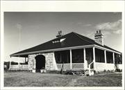
Bremer Bay Telegraph Station
Jerramungup
Great Southern
Constructed from 1896
| Type | Status | Date | Documents |
|---|---|---|---|
| (no listings) |
| Type | Status | Date | Documents |
|---|---|---|---|
| RHP - Does not warrant assessment | Current | 24 Sep 2004 |
| Type | Status | Date | Grading/Management | |
|---|---|---|---|---|
| Category | ||||
| Register of the National Estate | Registered | 25 Mar 1986 | ||
| Classified by the National Trust | Classified | 23 Aug 1979 | ||
| Register of the National Estate | Interim | 25 Mar 1986 | ||
| Municipal Inventory | Adopted | 17 Jul 1997 | Category 1 | |
Sound - external only
Individual Building or Group
| Epoch | General | Specific |
|---|---|---|
| Present Use | RESIDENTIAL | Single storey residence |
| Original Use | Transport\Communications | Comms: Post or Telegraph Office |
| Type | General | Specific |
|---|---|---|
| Wall | BRICK | Other Brick |
| Roof | METAL | Corrugated Iron |
| General | Specific |
|---|---|
| TRANSPORT & COMMUNICATIONS | Telecommunications |
This information is provided voluntarily as a public service. The information provided is made available in good faith and is derived from sources believed to be reliable and accurate. However, the information is provided solely on the basis that readers will be responsible for making their own assessment of the matters discussed herein and are advised to verify all relevant representations, statements and information.
Constructed from 1896
The dwelling is significant for the following reasons: The telegraph station has considerable architecture and historical significance. Its style is particularly Australian and blends well with the environment. It is built of local stone in a random rubble wall and originally covered in corrugated iron and has verandas on all sides. It has an interesting entrance and ballustrading. Also it was one of the stations that linked the west coast with the south and is important for the early history of the area.
The large former telegraph station and post office now a Single storey Residence, stone portico, stone chimneys, timber frammed double hung windows, symmetrical facade.
Extent of Original Fabric: 90%
Good
| Owner | Category |
|---|---|
| J Garnett | Other Private |
This information is provided voluntarily as a public service. The information provided is made available in good faith and is derived from sources believed to be reliable and accurate. However, the information is provided solely on the basis that readers will be responsible for making their own assessment of the matters discussed herein and are advised to verify all relevant representations, statements and information.
Fitzgerald River National Park, off Devils Creek Rd Bremer Bay
1.5km north of Bremer Bay
Jerramungup
Great Southern
Constructed from 1858 to 1940
| Type | Status | Date | Documents |
|---|---|---|---|
| State Register | Registered | 29 May 2009 | HCWebsite.Listing+ListingDocument, HCWebsite.Listing+ListingDocument |
| Type | Status | Date | Documents |
|---|---|---|---|
| (no listings) |
| Type | Status | Date | Grading/Management | |
|---|---|---|---|---|
| Category | ||||
| Municipal Inventory | Adopted | 17 Jul 1997 | Category 1 | |
| Register of the National Estate | Indicative Place | |||
| Classified by the National Trust | Classified | 25 Jul 1989 | ||
The original 1858 cottage and its 1940s addition were restored in 1973, and are generally in good condition. The roof of the barn was never replaced and now the barn is in very poor condition. It was solidly constructed; however a great deal of the fabric has been lost, including the stolen roof sheeting, roof framing and floor structure. While approximately 50% of the walling has collapsed, a great deal of the stone is extant on site.
Individual Building or Group
| Epoch | General | Specific |
|---|---|---|
| Original Use | FARMING\PASTORAL | Homestead |
| Present Use | RESIDENTIAL | Single storey residence |
| Style |
|---|
| Victorian Georgian |
| Type | General | Specific |
|---|---|---|
| Wall | STONE | Other Stone |
| Roof | METAL | Corrugated Iron |
| General | Specific |
|---|---|
| OCCUPATIONS | Rural industry & market gardening |
| PEOPLE | Early settlers |
| DEMOGRAPHIC SETTLEMENT & MOBILITY | Immigration, emigration & refugees |
| OCCUPATIONS | Grazing, pastoralism & dairying |
| DEMOGRAPHIC SETTLEMENT & MOBILITY | Racial contact & interaction |
| OUTSIDE INFLUENCES | Tourism |
| DEMOGRAPHIC SETTLEMENT & MOBILITY | Land allocation & subdivision |
This information is provided voluntarily as a public service. The information provided is made available in good faith and is derived from sources believed to be reliable and accurate. However, the information is provided solely on the basis that readers will be responsible for making their own assessment of the matters discussed herein and are advised to verify all relevant representations, statements and information.
Constructed from 1858, Constructed from 1940
The dwelling is significant for the following reasons: Historically the homestead is of importance for its association with pioneers John Wellstead and John Hassell. It is believed that the house was built by Wellstead about 1870 on his homestead block there and later was included in John Hassell’s pastoral lease. Hassell used Quaalup as an outstation of his Jerramungup property and for some years, c. 1890’s, his sheep on that part of the lease were shorn at Quaalup. The stone shearing shed no longer remains. Restoration has been carried out sympathetically and the building remains as a good example of the use of local materials and early methods of construction. Situated near the mouth of the Gairdner River and adjacent to the Fitzgerald National Park it is important in the environment.
Quaalup Homestead Group, near Bremer Bay is a property of 15.47 hectares located close to the Gairdner River. The property is one of a small number of adjacent lots that are in private ownership within the Fitzgerald River National Park. Quaalup Homestead Group, near Bremer Bay, comprises a single-storey quartzite stone house with a corrugated iron roof (1858, 1940), the remains of a quartzite barn (1858-70s) remains of cottage (date unknown), livestock enclosure (date unknown) and grave (1927).
The original 1858 cottage and its 1940s addition were restored in 1973, and are generally in good condition. The roof of the barn was never replaced and now the barn is in very poor condition. It was solidly constructed; however a great deal of the fabric has been lost, including the stolen roof sheeting, roof framing and floor structure. While approximately 50% of the walling has collapsed, a great deal of the stone is extant on site.
Extent of Original Fabric: 90%
Good
| Owner | Category |
|---|---|
| Department for Conservation and Land Management | State Gov't |
This information is provided voluntarily as a public service. The information provided is made available in good faith and is derived from sources believed to be reliable and accurate. However, the information is provided solely on the basis that readers will be responsible for making their own assessment of the matters discussed herein and are advised to verify all relevant representations, statements and information.
The Esplanade Bremer Bay
Jerramungup
Great Southern
| Type | Status | Date | Documents |
|---|---|---|---|
| (no listings) |
| Type | Status | Date | Documents |
|---|---|---|---|
| (no listings) |
| Type | Status | Date | Grading/Management | |
|---|---|---|---|---|
| Category | ||||
| Municipal Inventory | Adopted | 17 Jul 1997 | Category 2 | |
Individual Building or Group
| Epoch | General | Specific |
|---|---|---|
| Original Use | RESIDENTIAL | Single storey residence |
| Present Use | RESIDENTIAL | Single storey residence |
| Type | General | Specific |
|---|---|---|
| Roof | METAL | Corrugated Iron |
| Wall | TIMBER | Other Timber |
| General | Specific |
|---|---|
| DEMOGRAPHIC SETTLEMENT & MOBILITY | Settlements |
This information is provided voluntarily as a public service. The information provided is made available in good faith and is derived from sources believed to be reliable and accurate. However, the information is provided solely on the basis that readers will be responsible for making their own assessment of the matters discussed herein and are advised to verify all relevant representations, statements and information.
The dwelling is significant for the following reasons: One of the original dwellings constructed in Bremer Bay townsite.
Single storey brick construction with a corrrugated iron roof.
Extent of Original Fabric: 50%
Fair
| Owner | Category |
|---|---|
| M Krogdahl | Other Private |
This information is provided voluntarily as a public service. The information provided is made available in good faith and is derived from sources believed to be reliable and accurate. However, the information is provided solely on the basis that readers will be responsible for making their own assessment of the matters discussed herein and are advised to verify all relevant representations, statements and information.
Wellstead Rd Bremer Bay
Pt Henry Peninsula
Jerramungup
Great Southern
| Type | Status | Date | Documents |
|---|---|---|---|
| (no listings) |
| Type | Status | Date | Documents |
|---|---|---|---|
| (no listings) |
| Type | Status | Date | Grading/Management | |
|---|---|---|---|---|
| Category | ||||
| Municipal Inventory | Adopted | 17 Jul 1997 | Category 2 | |
11696 Wellsteads' Homestead Group
Individual Building or Group
| Epoch | General | Specific |
|---|---|---|
| Original Use | FARMING\PASTORAL | Homestead |
| Type | General | Specific |
|---|---|---|
| Roof | METAL | Corrugated Iron |
| Wall | STONE | Other Stone |
| General | Specific |
|---|---|
| TRANSPORT & COMMUNICATIONS | Technology & technological change |
This information is provided voluntarily as a public service. The information provided is made available in good faith and is derived from sources believed to be reliable and accurate. However, the information is provided solely on the basis that readers will be responsible for making their own assessment of the matters discussed herein and are advised to verify all relevant representations, statements and information.
Constructed from 1858, Constructed from 1970
The dwelling is significant for the following reasons: The original homestead built by John Wellstead.
Extent of Original Fabric: 90%
Good
| Owner | Category |
|---|---|
| WM Wellstead | Other Private |
This information is provided voluntarily as a public service. The information provided is made available in good faith and is derived from sources believed to be reliable and accurate. However, the information is provided solely on the basis that readers will be responsible for making their own assessment of the matters discussed herein and are advised to verify all relevant representations, statements and information.
Wellstead Rd, Point Henry Peninsula Bremer Bay
Mount Joy
Wellstead's Station; Peppermint Grove
Jerramungup
Great Southern
Constructed from 1857 to 1884
| Type | Status | Date | Documents |
|---|---|---|---|
| State Register | Registered | 17 Oct 2008 | HCWebsite.Listing+ListingDocument, HCWebsite.Listing+ListingDocument |
| Type | Status | Date | Documents |
|---|---|---|---|
| (no listings) |
| Type | Status | Date | Grading/Management | |
|---|---|---|---|---|
| Category | ||||
| Municipal Inventory | Adopted | 17 Jul 1997 | Category 2 | |
Good
| Library Id | Title | Medium | Year Of Publication |
|---|---|---|---|
| 11720 | The Wellstead legacy | Video | |
| 9585 | Wellsteads' homstead: conservation works to barn, final report, July 2010. | Conservation works report | 2010 |
Individual Building or Group
| Epoch | General | Specific |
|---|---|---|
| Present Use | FARMING\PASTORAL | Other |
| Original Use | FARMING\PASTORAL | Homestead |
| Style |
|---|
| Victorian Georgian |
| Type | General | Specific |
|---|---|---|
| Roof | METAL | Corrugated Iron |
| Wall | STONE | Other Stone |
| General | Specific |
|---|---|
| DEMOGRAPHIC SETTLEMENT & MOBILITY | Settlements |
| PEOPLE | Local heroes & battlers |
| DEMOGRAPHIC SETTLEMENT & MOBILITY | Racial contact & interaction |
| TRANSPORT & COMMUNICATIONS | Technology & technological change |
| DEMOGRAPHIC SETTLEMENT & MOBILITY | Workers {incl. Aboriginal, convict} |
| OUTSIDE INFLUENCES | Tourism |
| OCCUPATIONS | Grazing, pastoralism & dairying |
| PEOPLE | Early settlers |
| DEMOGRAPHIC SETTLEMENT & MOBILITY | Land allocation & subdivision |
This information is provided voluntarily as a public service. The information provided is made available in good faith and is derived from sources believed to be reliable and accurate. However, the information is provided solely on the basis that readers will be responsible for making their own assessment of the matters discussed herein and are advised to verify all relevant representations, statements and information.
Constructed from 1857, Constructed from 1884
11696 Wellsteads' Homestead Group
The dwelling is significant for the following reasons: The original house built for settlement and farming at Bremer Bay by the Wellstead family.
A substantial complex of mostly granite construction buildings including two homesteads, separate buildings known as the Boys' Room and the Girls' Room (converted from sheep pens), workshops, wool barn and shearing shed with associated engine room, and stables, built in the 19th century, with a rebuilt granite cottage on the site of the first building (1850), and more recent farm and Museum buildings, together with a large collection of artefacts, dating from the mid-19th century, continuing in the family of the original owner, John Wellstead.
Extent of Original Fabric: 5%
Poor
This information is provided voluntarily as a public service. The information provided is made available in good faith and is derived from sources believed to be reliable and accurate. However, the information is provided solely on the basis that readers will be responsible for making their own assessment of the matters discussed herein and are advised to verify all relevant representations, statements and information.
72 Cameron Rd Jerramungup
6 kms east of townsite 72 Cameron Rd, Jerramungup
Hassell Homestead and Barn
Jerramungup
Great Southern
Constructed from 1848
| Type | Status | Date | Documents |
|---|---|---|---|
| (no listings) |
| Type | Status | Date | Documents |
|---|---|---|---|
| RHP - To be assessed | Current | 13 Aug 2004 |
| Type | Status | Date | Grading/Management | |
|---|---|---|---|---|
| Category | ||||
| Classified by the National Trust | Recorded | 08 Jun 1976 | ||
| Register of the National Estate | Indicative Place | |||
| Municipal Inventory | Adopted | 17 Jul 1997 | Category 1 | |
• The place is associated with the settlement and development of Jerramungup.
• The place is an example of a small original homestead in a rural area.
• The place is closely associated with the Hassell family.
Stone walls Corrugated iron roof Front verandah has collapsed House is small (possible only 4 rooms or less) House faces adjacent Gairdener River.
The Shire of Jerramungup Municipal Inventory states: ‘The old stone house with nearby store and barn was built by the Hassells (1859-61) and used by the family until the erection of the new house in 1906. No longer habitable but capable of being preserved without further deterioration these buildings are mainly of historical interest. Jerramungup, as the Hassells used to call the property – was taken up by John Hassell in 1849 and was one of the best known stations in the south of Western Australia. Mentioned in the journals of a number of explorers and remained in the ownership of the Hassell family for over 100 years, until bought for War Service land settlement in 1951.’
Integrity- Moderate Authenticity- High
Poor
| Name | Type | Year From | Year To |
|---|---|---|---|
| Hassell, John | Architect | - | - |
Individual Building or Group
| Epoch | General | Specific |
|---|---|---|
| Present Use | FARMING\PASTORAL | Homestead |
| Other Use | FARMING\PASTORAL | Shed or Barn |
| Original Use | FARMING\PASTORAL | Homestead |
| Style |
|---|
| Victorian Georgian |
| Type | General | Specific |
|---|---|---|
| Wall | STONE | Other Stone |
| Roof | METAL | Corrugated Iron |
| General | Specific |
|---|---|
| OCCUPATIONS | Grazing, pastoralism & dairying |
This information is provided voluntarily as a public service. The information provided is made available in good faith and is derived from sources believed to be reliable and accurate. However, the information is provided solely on the basis that readers will be responsible for making their own assessment of the matters discussed herein and are advised to verify all relevant representations, statements and information.
Constructed from 1848
The dwelling is significant for the following reasons: The old stone house with nearby store and barn was built by the Hassells (1859-61) and used by the family until the erection of the new house in 1906. No longer habitable but capable of being preserved further without deterioration there buildings are mainly of historical interest. Jerramungup – as the Hassells used to call the property – was taken up by John Hassell in 1849 and was one of the best known stations in the south of W.A. – mentioned in the journals of a number of explorers and remained in the ownership of the Hassell family for over 100 years (until brought for War Service land Settlement in 1951).
Extent of Original Fabric; 70%
Good
| Owner | Category |
|---|---|
| R Parsons | Other Private |
This information is provided voluntarily as a public service. The information provided is made available in good faith and is derived from sources believed to be reliable and accurate. However, the information is provided solely on the basis that readers will be responsible for making their own assessment of the matters discussed herein and are advised to verify all relevant representations, statements and information.
Gordon Inlet Rd Jerramungup
Part Lot 2132 on DP 414180 and part lot 2131 on DP 240398 and part reserve 32666
Jerramungup
Great Southern
| Type | Status | Date | Documents |
|---|---|---|---|
| (no listings) |
| Type | Status | Date | Documents |
|---|---|---|---|
| RHP - Does not warrant assessment | Current | 11 Mar 2022 |
| Type | Status | Date | Grading/Management | |
|---|---|---|---|---|
| Category | ||||
| (no listings) | ||||
Two sites comprising multiple beach shacks. The shack at site one is a small open structure with fishing facilities and is constructed alongsite inlet. There are multiple structures at site two which vary in size, including modern amenities, security and living facility. Site two is located alongside the beach.
Individual Building or Group
| Epoch | General | Specific |
|---|---|---|
| Original Use | SOCIAL\RECREATIONAL | Other |
| Present Use | SOCIAL\RECREATIONAL | Other |
| Type | General | Specific |
|---|---|---|
| Wall | METAL | Tin |
| Wall | TIMBER | Other Timber |
| Wall | METAL | Steel |
| Other | CONCRETE | Other Concrete |
This information is provided voluntarily as a public service. The information provided is made available in good faith and is derived from sources believed to be reliable and accurate. However, the information is provided solely on the basis that readers will be responsible for making their own assessment of the matters discussed herein and are advised to verify all relevant representations, statements and information.
Cnr Lancaster & Memorial R ds Jerramungup
high school is 2 Lancaster Road BDD 10-1-12
Jerramungup
Great Southern
Constructed from 1958
| Type | Status | Date | Documents |
|---|---|---|---|
| (no listings) |
| Type | Status | Date | Documents |
|---|---|---|---|
| (no listings) |
| Type | Status | Date | Grading/Management | |
|---|---|---|---|---|
| Category | ||||
| Municipal Inventory | Adopted | 17 Jul 1997 | Category 3 | |
Individual Building or Group
| Epoch | General | Specific |
|---|---|---|
| Original Use | EDUCATIONAL | Combined School |
| Present Use | EDUCATIONAL | Combined School |
| Type | General | Specific |
|---|---|---|
| Wall | TIMBER | Other Timber |
| Roof | METAL | Corrugated Iron |
| General | Specific |
|---|---|
| SOCIAL & CIVIC ACTIVITIES | Education & science |
This information is provided voluntarily as a public service. The information provided is made available in good faith and is derived from sources believed to be reliable and accurate. However, the information is provided solely on the basis that readers will be responsible for making their own assessment of the matters discussed herein and are advised to verify all relevant representations, statements and information.
Constructed from 1958
The dwelling is significant for the following reasons: First school built to service the district
Extent of Original Fabric: 70%
Good
| Owner | Category |
|---|---|
| Dept of Educaton | State Gov't |
This information is provided voluntarily as a public service. The information provided is made available in good faith and is derived from sources believed to be reliable and accurate. However, the information is provided solely on the basis that readers will be responsible for making their own assessment of the matters discussed herein and are advised to verify all relevant representations, statements and information.
8 Lancaster Rd Jerramungup
Jerramungup
Great Southern
| Type | Status | Date | Documents |
|---|---|---|---|
| (no listings) |
| Type | Status | Date | Documents |
|---|---|---|---|
| (no listings) |
| Type | Status | Date | Grading/Management | |
|---|---|---|---|---|
| Category | ||||
| Uniting Church Inventory | Completed | 01 Oct 1996 | ||
Individual Building or Group
| Epoch | General | Specific |
|---|---|---|
| Original Use | RELIGIOUS | Housing or Quarters |
| Present Use | RELIGIOUS | Housing or Quarters |
| Type | General | Specific |
|---|---|---|
| Roof | METAL | Corrugated Iron |
| Wall | BRICK | Common Brick |
| General | Specific |
|---|---|
| SOCIAL & CIVIC ACTIVITIES | Religion |
This information is provided voluntarily as a public service. The information provided is made available in good faith and is derived from sources believed to be reliable and accurate. However, the information is provided solely on the basis that readers will be responsible for making their own assessment of the matters discussed herein and are advised to verify all relevant representations, statements and information.
Memorial Rd Jerramungup
Landcare Office
Jerramungup
Great Southern
Constructed from 1953
| Type | Status | Date | Documents |
|---|---|---|---|
| (no listings) |
| Type | Status | Date | Documents |
|---|---|---|---|
| (no listings) |
| Type | Status | Date | Grading/Management | |
|---|---|---|---|---|
| Category | ||||
| Municipal Inventory | Adopted | 17 Jul 1997 | Category 2 | |
Individual Building or Group
| Epoch | General | Specific |
|---|---|---|
| Original Use | COMMERCIAL | Office or Administration Bldg |
| Present Use | COMMERCIAL | Office or Administration Bldg |
| Type | General | Specific |
|---|---|---|
| Wall | BRICK | Other Brick |
| Roof | METAL | Corrugated Iron |
| General | Specific |
|---|---|
| SOCIAL & CIVIC ACTIVITIES | Community services & utilities |
This information is provided voluntarily as a public service. The information provided is made available in good faith and is derived from sources believed to be reliable and accurate. However, the information is provided solely on the basis that readers will be responsible for making their own assessment of the matters discussed herein and are advised to verify all relevant representations, statements and information.
Constructed from 1953
The place is significant for the following reasons: The original building built for C. Cameron for the War Service Settlement Scheme.
Single storey brick construction with a corrugated iron roof.
Extent of Original Fabric: 70%
Good
| Owner | Category |
|---|---|
| Shire of Jerramungup | Local Gov't |
This information is provided voluntarily as a public service. The information provided is made available in good faith and is derived from sources believed to be reliable and accurate. However, the information is provided solely on the basis that readers will be responsible for making their own assessment of the matters discussed herein and are advised to verify all relevant representations, statements and information.
Memorial Rd Jerramungup
Jerramungup
Great Southern
Constructed from 1958
| Type | Status | Date | Documents |
|---|---|---|---|
| (no listings) |
| Type | Status | Date | Documents |
|---|---|---|---|
| (no listings) |
| Type | Status | Date | Grading/Management | |
|---|---|---|---|---|
| Category | ||||
| Municipal Inventory | Adopted | 17 Jul 1997 | Category 3 | |
Individual Building or Group
| Epoch | General | Specific |
|---|---|---|
| Original Use | GOVERNMENTAL | Town, Shire or District Hall |
| Present Use | GOVERNMENTAL | Town, Shire or District Hall |
| Type | General | Specific |
|---|---|---|
| Roof | METAL | Corrugated Iron |
| Wall | OTHER | Other Material |
| General | Specific |
|---|---|
| SOCIAL & CIVIC ACTIVITIES | Government & politics |
This information is provided voluntarily as a public service. The information provided is made available in good faith and is derived from sources believed to be reliable and accurate. However, the information is provided solely on the basis that readers will be responsible for making their own assessment of the matters discussed herein and are advised to verify all relevant representations, statements and information.
Constructed from 1958
The place is significant for the following reasons: First town hall built in Jerramungup. Built with funds raised by the community
Single storey metal and iron construction.
Extent of Original Fabric: 70%
Good
| Owner | Category |
|---|---|
| Shire of Jerramungup | Local Gov't |
This information is provided voluntarily as a public service. The information provided is made available in good faith and is derived from sources believed to be reliable and accurate. However, the information is provided solely on the basis that readers will be responsible for making their own assessment of the matters discussed herein and are advised to verify all relevant representations, statements and information.
Memorial Rd Jerramungup
Adjacent to Town Hall
Jerramungup
Great Southern
| Type | Status | Date | Documents |
|---|---|---|---|
| (no listings) |
| Type | Status | Date | Documents |
|---|---|---|---|
| (no listings) |
| Type | Status | Date | Grading/Management | |
|---|---|---|---|---|
| Category | ||||
| Statewide War Memorial Survey | Completed | 01 May 1996 | ||
11701 Jerramungup Town Hall
Historic site
| Epoch | General | Specific |
|---|---|---|
| Original Use | MONUMENT\CEMETERY | Monument |
| Present Use | MONUMENT\CEMETERY | Monument |
| Type | General | Specific |
|---|---|---|
| Other | METAL | Other Metal |
| Other | STONE | Local Stone |
This information is provided voluntarily as a public service. The information provided is made available in good faith and is derived from sources believed to be reliable and accurate. However, the information is provided solely on the basis that readers will be responsible for making their own assessment of the matters discussed herein and are advised to verify all relevant representations, statements and information.
Tobruk Rd Jerramungup
Jerramungup
Great Southern
Constructed from 1963
| Type | Status | Date | Documents |
|---|---|---|---|
| (no listings) |
| Type | Status | Date | Documents |
|---|---|---|---|
| (no listings) |
| Type | Status | Date | Grading/Management | |
|---|---|---|---|---|
| Category | ||||
| Municipal Inventory | Adopted | 17 Jul 1997 | Category 4 | |
Individual Building or Group
| Epoch | General | Specific |
|---|---|---|
| Original Use | GOVERNMENTAL | Power Station |
| Present Use | COMMERCIAL | Warehouse |
| Type | General | Specific |
|---|---|---|
| Wall | METAL | Other Metal |
| Roof | METAL | Corrugated Iron |
| General | Specific |
|---|---|
| DEMOGRAPHIC SETTLEMENT & MOBILITY | Settlements |
This information is provided voluntarily as a public service. The information provided is made available in good faith and is derived from sources believed to be reliable and accurate. However, the information is provided solely on the basis that readers will be responsible for making their own assessment of the matters discussed herein and are advised to verify all relevant representations, statements and information.
Constructed from 1963
The place is significant for the following reasons: The first power supply for Jerramungup and surrounding area.
Single storey metal and iron construction.
Extent of Original Fabric: 70%
Good
| Owner | Category |
|---|---|
| Shire of Jerramungup | Local Gov't |
This information is provided voluntarily as a public service. The information provided is made available in good faith and is derived from sources believed to be reliable and accurate. However, the information is provided solely on the basis that readers will be responsible for making their own assessment of the matters discussed herein and are advised to verify all relevant representations, statements and information.
Vasey St Jerramungup
Cnr Vasey & Truscott St
Jerramungup
Great Southern
Constructed from 2009
| Type | Status | Date | Documents |
|---|---|---|---|
| (no listings) |
| Type | Status | Date | Documents |
|---|---|---|---|
| RHP - Does not warrant assessment | Current | 28 Sep 2012 |
| Type | Status | Date | Grading/Management | |
|---|---|---|---|---|
| Category | ||||
| (no listings) | ||||
Individual Building or Group
| Epoch | General | Specific |
|---|---|---|
| Present Use | GOVERNMENTAL | Police Station or Quarters |
This information is provided voluntarily as a public service. The information provided is made available in good faith and is derived from sources believed to be reliable and accurate. However, the information is provided solely on the basis that readers will be responsible for making their own assessment of the matters discussed herein and are advised to verify all relevant representations, statements and information.
Vasey St Jerramungup
Jerramungup
Great Southern
Constructed from 1982
| Type | Status | Date | Documents |
|---|---|---|---|
| (no listings) |
| Type | Status | Date | Documents |
|---|---|---|---|
| (no listings) |
| Type | Status | Date | Grading/Management | |
|---|---|---|---|---|
| Category | ||||
| Municipal Inventory | Adopted | 17 Jul 1997 | Category 4 | |
Individual Building or Group
| Epoch | General | Specific |
|---|---|---|
| Original Use | GOVERNMENTAL | Office or Administration Bldg |
| Present Use | GOVERNMENTAL | Office or Administration Bldg |
| Type | General | Specific |
|---|---|---|
| Roof | METAL | Corrugated Iron |
| Wall | BRICK | Other Brick |
| General | Specific |
|---|---|
| SOCIAL & CIVIC ACTIVITIES | Government & politics |
This information is provided voluntarily as a public service. The information provided is made available in good faith and is derived from sources believed to be reliable and accurate. However, the information is provided solely on the basis that readers will be responsible for making their own assessment of the matters discussed herein and are advised to verify all relevant representations, statements and information.
Constructed from 1982
The place is significant for the following reasons: The first office built for the newly formed Shire of Jerramungup
Single storey brick construction with a corrugated iron roof.
Good
| Owner | Category |
|---|---|
| Shire of Jerramungup | Local Gov't |
This information is provided voluntarily as a public service. The information provided is made available in good faith and is derived from sources believed to be reliable and accurate. However, the information is provided solely on the basis that readers will be responsible for making their own assessment of the matters discussed herein and are advised to verify all relevant representations, statements and information.
Northampton to Ravensthorpe
Goes thro following LGAs: Northampton, Yalgoo, Perenjori, Dalwallinu, Wongan-Ballidu, Koorda, Dowerin, Cunderdin, Tammin, Quairading, Corrigin, Wickepin, Kulin, Dumbleyung, Kent, Gnowangerup, Jerramungup, Ravensthorpe. Almost parallel with No 1 Fence, 100 km or so further west.
Emu Barrier Fence
Corrigin
Wheatbelt
Constructed from 1906 to 1908
| Type | Status | Date | Documents |
|---|---|---|---|
| (no listings) |
| Type | Status | Date | Documents |
|---|---|---|---|
| RHP - Does not warrant assessment | Current | 25 Nov 2005 |
| Type | Status | Date | Grading/Management | |
|---|---|---|---|---|
| Category | ||||
| Municipal Inventory | Adopted | 17 Oct 2002 | Category D | |
Good - although it varies along the route
Other Built Type
| Epoch | General | Specific |
|---|---|---|
| Original Use | GOVERNMENTAL | Other |
| Present Use | GOVERNMENTAL | Other |
| Type | General | Specific |
|---|---|---|
| Other | METAL | Other Metal |
| General | Specific |
|---|---|
| OCCUPATIONS | Rural industry & market gardening |
| SOCIAL & CIVIC ACTIVITIES | Government & politics |
This information is provided voluntarily as a public service. The information provided is made available in good faith and is derived from sources believed to be reliable and accurate. However, the information is provided solely on the basis that readers will be responsible for making their own assessment of the matters discussed herein and are advised to verify all relevant representations, statements and information.
Constructed from 1907
The Rabbit Proof Fence has historic and representative cultural heritage significance. The Fence was a major attempt by the WA Government to prevent the pestilence of rabbits, an introduced animal to Australia. The Rabbit Proof Fence No.2 divides the Shire of Dumbleyung and has had a marked influence on the history of land development in the region. Names of roads in the district east of Dumbleyung reflect the effect of the Fence with Fence Rd and 125 Gate Rd being two examples. The fence, though extremely long and crossing many Local Government Areas throughout WA, had a particularly strong influence over land development patterns in Dumbleyung and is representative of early government attempts to help sustain agriculture.
In the late 19th century rabbits which were not established in WA, were recognised as a possible menace to agriculture. The rabbits were travelling from the eastern seaboard at a rate of 35 miles a year and the Western Australian Government formed a plan to try and prevent the pests entry. A decision was made to construct a rabbit proof fence from the 80 Mile Beach in the north, through the Great Sandy Desert to end at Starvation Beach near Esperance in the south. When Rabbit Proof Fence Number One was completed in 1903, it was the longest unbroken line of fence in the world. However, on its completion rabbits had already appeared west of the barrier. Another fence was therefore hurriedly erected roughly 60 miles parallel inside the first. It was built in the period between March and July 1904. The fence was constructed of jam posts placed 12 feet apart with wire netting of which the lowest 6 inches were dipped in coal tar and buried (towards the east) to prevent the rabbits from digging under. A wide clearing either side provided for a fire break and access for boundary riders. The second fence built divided the Dumbleyung district. The fence was kept in order by Government employees. Riders were employed to check the fence, using bicycles for transport. Gates in the fence needed to be opened and closed each time and location was often determined by the gate number (eg. 125 Gate Rd). The many gates made collection of water difficult for some farmers who had to travel many miles to a water supply. The first rabbit proof fence was abandoned in 1916 when it was obvious it had failed and that more time was needed maintaining the second fence. By the 1940s it was realised that the rabbit proof fence had failed but the gates were still patrolled and fines were issued if left open. This vigilance was maintained into the 1950s In 1959 the Rabbit Proof Fence Department was finally disbanded and the gates were left permanently open. At the same time myxomatosis was introduced which greatly reduced the rabbit population. Today the rabbit proof fence is still referred to as 'the fence'. Though no longer a physical divide, people still talk in terms of their community being east or west of the fence.
| Ref ID No | Ref Name | Ref Source | Ref Date |
|---|---|---|---|
| J Timperley; "Beyond the Fence: A History of Kukerin, Moluyinning and Nearby Communities". | 1996 | ||
| O'Brien Planning Consultants; "Municipal Heritage Inventory". | Shire of Dumbleyung | 1998 |
This information is provided voluntarily as a public service. The information provided is made available in good faith and is derived from sources believed to be reliable and accurate. However, the information is provided solely on the basis that readers will be responsible for making their own assessment of the matters discussed herein and are advised to verify all relevant representations, statements and information.