Local Government
Kalamunda
Region
Metropolitan
Schipp Rd Piesse Brook
on the left, just off end of schipp rd, in kalamunda national park
Kalamunda
Metropolitan
Constructed from 1910
| Type | Status | Date | Documents |
|---|---|---|---|
| (no listings) |
| Type | Status | Date | Documents |
|---|---|---|---|
| (no listings) |
| Type | Status | Date | Grading/Management | |
|---|---|---|---|---|
| Category | ||||
| (no listings) | ||||
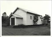
Historic Site
| Epoch | General | Specific |
|---|---|---|
| Original Use | MINING | Mining Battery |
| Present Use | PARK\RESERVE | Park\Reserve |
| Type | General | Specific |
|---|---|---|
| Wall | TIMBER | Other Timber |
| Roof | METAL | Corrugated Iron |
| General | Specific |
|---|---|
| OCCUPATIONS | Mining {incl. mineral processing} |
This information is provided voluntarily as a public service. The information provided is made available in good faith and is derived from sources believed to be reliable and accurate. However, the information is provided solely on the basis that readers will be responsible for making their own assessment of the matters discussed herein and are advised to verify all relevant representations, statements and information.
24 Boronia Rd Walliston
Ted's Shed
Kalamunda
Metropolitan
Constructed from 1925
| Type | Status | Date | Documents |
|---|---|---|---|
| (no listings) |
| Type | Status | Date | Documents |
|---|---|---|---|
| (no listings) |
| Type | Status | Date | Grading/Management | |
|---|---|---|---|---|
| Category | ||||
| Municipal Inventory | Adopted | 01 Aug 2013 | Category 2 | |
Individual Building or Group
| Epoch | General | Specific |
|---|---|---|
| Original Use | FARMING\PASTORAL | Shed or Barn |
| Present Use | FARMING\PASTORAL | Shed or Barn |
| Type | General | Specific |
|---|---|---|
| Roof | METAL | Corrugated Iron |
| Wall | METAL | Corrugated Iron |
| General | Specific |
|---|---|
| OCCUPATIONS | Rural industry & market gardening |
This information is provided voluntarily as a public service. The information provided is made available in good faith and is derived from sources believed to be reliable and accurate. However, the information is provided solely on the basis that readers will be responsible for making their own assessment of the matters discussed herein and are advised to verify all relevant representations, statements and information.
Constructed from 1930, Constructed from 1925
· The place has historic value for its association with the establishment and development of the fruit growing industry in the district. · The place has historic value for its association with local identities Archibald Sanderson and Ted Saunders. · The place has social value for the community members who have visited the building for work or purchasing feed supplies. · The place has research value as a demonstration of old work practices and techniques.
Double height galvanised iron shed with gable roof and additions to both ends. Clad in short sheet corrugated sheets. Stumped construction. No internal inspection was undertaken but it is reported that there is a well in the corner of the shed.
Level of Integrity - High; Level of Authenticity - High
Poor and failing condition. New development being constructed adjacent to he shed in the garden. This large shed was built c1925 for local builder Bill McClure for owner Archibald Sanderson (1870-1937). Sanderson was a journalist and significant landholder in the Lesmurdie district where he established an orchard and built his home, Lesmurdie House. Sanderson was active in the local community and this shed was his contribution to the Walliston Co-operative growers in the district. Originally there was a deep well in the corner of the shed and water from the well was used to make fruit cordial. In the 1930s a case mill, for the manufacture of fruit cases, was added. In the 1950s, the property was transferred to Ted Saunders who used the shed for the storage of stock feed.
| Ref ID No | Ref Name | Ref Source | Ref Date |
|---|---|---|---|
| MOV, pp 141-143 & p 148 (photo) |
| Reserve | Lot/Location | Plan/Diagram | Vol/Folio |
|---|---|---|---|
| Lot 1 | D80686 | 1971-803 |
This information is provided voluntarily as a public service. The information provided is made available in good faith and is derived from sources believed to be reliable and accurate. However, the information is provided solely on the basis that readers will be responsible for making their own assessment of the matters discussed herein and are advised to verify all relevant representations, statements and information.
280 Canning Rd Walliston
in amongst orchard trees
Kalamunda
Metropolitan
Constructed from 1905
| Type | Status | Date | Documents |
|---|---|---|---|
| (no listings) |
| Type | Status | Date | Documents |
|---|---|---|---|
| (no listings) |
| Type | Status | Date | Grading/Management | |
|---|---|---|---|---|
| Category | ||||
| (no listings) | ||||
Individual Building or Group
| Epoch | General | Specific |
|---|---|---|
| Present Use | INDUSTRIAL\MANUFACTURING | Other |
| Original Use | RESIDENTIAL | Single storey residence |
| Type | General | Specific |
|---|---|---|
| Wall | METAL | Corrugated Iron |
| Roof | METAL | Corrugated Iron |
| General | Specific |
|---|---|
| PEOPLE | Early settlers |
This information is provided voluntarily as a public service. The information provided is made available in good faith and is derived from sources believed to be reliable and accurate. However, the information is provided solely on the basis that readers will be responsible for making their own assessment of the matters discussed herein and are advised to verify all relevant representations, statements and information.
35 Grove Rd Walliston
Kalamunda
Metropolitan
Constructed from 1948
| Type | Status | Date | Documents |
|---|---|---|---|
| (no listings) |
| Type | Status | Date | Documents |
|---|---|---|---|
| (no listings) |
| Type | Status | Date | Grading/Management | |
|---|---|---|---|---|
| Category | ||||
| Municipal Inventory | Adopted | 01 Aug 2013 | Category 3 | |
Individual Building or Group
| Epoch | General | Specific |
|---|---|---|
| Present Use | RESIDENTIAL | Single storey residence |
| Original Use | Transport\Communications | Comms: Post or Telegraph Office |
| Type | General | Specific |
|---|---|---|
| Roof | METAL | Corrugated Iron |
| Wall | ASBESTOS | Fibrous Cement, flat |
| General | Specific |
|---|---|
| TRANSPORT & COMMUNICATIONS | Mail services |
This information is provided voluntarily as a public service. The information provided is made available in good faith and is derived from sources believed to be reliable and accurate. However, the information is provided solely on the basis that readers will be responsible for making their own assessment of the matters discussed herein and are advised to verify all relevant representations, statements and information.
Constructed from 1948
· The site has historic value for its association with the provision of postal services to small communities from a residence
This single storey timber framed cottage is clad with fibre cement sheeting. The hipped roof extends down to form the verandah canopy with a broken pitch over the verandah. The roof and verandah are clad in short sheet galvanised iron. The windows are aluminium framed sliding openings. An extensive carport and verandah have been constructed to the front of the house with a skillion canopy supported on cylindrical metal columns.
Mail services
Level of Integrity - None; Level of Authenticity - None
Good This site was the location of a residence that was used as a post office for the Walliston community. The residence was built by Walter Henry Morfitt (1904-1960) and his wife Ida Frances Morfitt (1905-1995). Ida Morfitt was appointed post mistress in 1950 until the closure of the post office in 1973. The residence was demolished.
| Ref ID No | Ref Name | Ref Source | Ref Date |
|---|---|---|---|
| Lewis J; "A History of Post Office int he Kalamunda Area". | Bill Shaw Award entry, | 1982 |
| Reserve | Lot/Location | Plan/Diagram | Vol/Folio |
|---|---|---|---|
| Lot 1 | D42702 | 1345-156 |
This information is provided voluntarily as a public service. The information provided is made available in good faith and is derived from sources believed to be reliable and accurate. However, the information is provided solely on the basis that readers will be responsible for making their own assessment of the matters discussed herein and are advised to verify all relevant representations, statements and information.
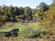
Lawnbrook Rd Walliston
Walliston Recreation Ground
Kalamunda
Metropolitan
Constructed from 1947
| Type | Status | Date | Documents |
|---|---|---|---|
| (no listings) |
| Type | Status | Date | Documents |
|---|---|---|---|
| (no listings) |
| Type | Status | Date | Grading/Management | |
|---|---|---|---|---|
| Category | ||||
| (no listings) | ||||
Individual Building or Group
| Epoch | General | Specific |
|---|---|---|
| Original Use | SOCIAL\RECREATIONAL | Other Community Hall\Centre |
| Present Use | SOCIAL\RECREATIONAL | Other Community Hall\Centre |
| Type | General | Specific |
|---|---|---|
| Wall | ASBESTOS | Fibrous Cement, flat |
| Wall | METAL | Corrugated Iron |
| Wall | TIMBER | Weatherboard |
| Roof | METAL | Corrugated Iron |
| General | Specific |
|---|---|
| SOCIAL & CIVIC ACTIVITIES | Sport, recreation & entertainment |
This information is provided voluntarily as a public service. The information provided is made available in good faith and is derived from sources believed to be reliable and accurate. However, the information is provided solely on the basis that readers will be responsible for making their own assessment of the matters discussed herein and are advised to verify all relevant representations, statements and information.
61 Lawnbrook Rd West Walliston
Carmel Methodist Church (fmr)
Kalamunda
Metropolitan
Constructed from 1915
| Type | Status | Date | Documents |
|---|---|---|---|
| (no listings) |
| Type | Status | Date | Documents |
|---|---|---|---|
| (no listings) |
| Type | Status | Date | Grading/Management | |
|---|---|---|---|---|
| Category | ||||
| Municipal Inventory | Adopted | 01 Aug 2013 | ||
| Uniting Church Inventory | Completed | 01 Oct 1996 | ||
Individual Building or Group
| Epoch | General | Specific |
|---|---|---|
| Present Use | RELIGIOUS | Church, Cathedral or Chapel |
| Original Use | RELIGIOUS | Church, Cathedral or Chapel |
| Type | General | Specific |
|---|---|---|
| Roof | METAL | Corrugated Iron |
| Wall | ASBESTOS | Fibrous Cement, flat |
| General | Specific |
|---|---|
| SOCIAL & CIVIC ACTIVITIES | Religion |
This information is provided voluntarily as a public service. The information provided is made available in good faith and is derived from sources believed to be reliable and accurate. However, the information is provided solely on the basis that readers will be responsible for making their own assessment of the matters discussed herein and are advised to verify all relevant representations, statements and information.
Constructed from 1915, Constructed from 1962
· The place has historic value for its association with early settlers the Wallis family · The site has social value for its association with the former Methodist church at this location which was the venue for many community events.
Laterite stone bench with concrete capping. Incorporates a memorial plaque to Kate and Fred Wallis.
Local heroes, religion, technology Church built 1915 in Carmel. Moved to Lawnbrook Rd site 1962
Level of Integrity - High; Level of Authenticity - High
Good This site was the location of the Methodist Church built in 1915 at a location in Carmel. The hall was relocated to this site in 1961. At the time of the relocation a stone bench seat was built in memory of early settlers Kate and Fred Wallis. The plaque on the bench reads ‘REST AWHILE. A tribute to the memory of our loved parents, Kate and Fred Wallis, 1880-1961’. Frederick Rueben Wallis (1880-1961) was an orchardist and an active community member, particularly of the Methodist church. Kate Winifred Wallis (nee Edwards) (1881-1960) brought up her five children in the Walliston district. The church has since been demolished but the bench remains.
| Ref ID No | Ref Name | Ref Source | Ref Date |
|---|---|---|---|
| Wallis P; "Memories of Walliston", | 1992 |
| Reserve | Lot/Location | Plan/Diagram | Vol/Folio |
|---|---|---|---|
| Lot 175 | P73020 | 2833-898 |
| Owner | Category |
|---|---|
| Uniting Church of Australia | Church Property |
This information is provided voluntarily as a public service. The information provided is made available in good faith and is derived from sources believed to be reliable and accurate. However, the information is provided solely on the basis that readers will be responsible for making their own assessment of the matters discussed herein and are advised to verify all relevant representations, statements and information.
98 Lawnbrook Rd West Walliston
Mr Fred Wallis' Property
Kalamunda
Metropolitan
Constructed from 1919
| Type | Status | Date | Documents |
|---|---|---|---|
| (no listings) |
| Type | Status | Date | Documents |
|---|---|---|---|
| (no listings) |
| Type | Status | Date | Grading/Management | |
|---|---|---|---|---|
| Category | ||||
| Municipal Inventory | Adopted | 01 Aug 2013 | Category 3 | |
Individual Building or Group
| Epoch | General | Specific |
|---|---|---|
| Original Use | RESIDENTIAL | Single storey residence |
| Present Use | RESIDENTIAL | Single storey residence |
| Type | General | Specific |
|---|---|---|
| Wall | TIMBER | Weatherboard |
| Roof | METAL | Corrugated Iron |
| General | Specific |
|---|---|
| OCCUPATIONS | Domestic activities |
This information is provided voluntarily as a public service. The information provided is made available in good faith and is derived from sources believed to be reliable and accurate. However, the information is provided solely on the basis that readers will be responsible for making their own assessment of the matters discussed herein and are advised to verify all relevant representations, statements and information.
Constructed from 1919
· The place has historic value for its association with the establishment and development of the district for orchards · The place has social value for the role it played in bringing the community together since 1919
Single storey rendered property with hipped and gablet corrugated metal roof. The property has been altered as the original dwelling was weatherboard. Extensive verandah supported on timber columns. Set back from the roadside in native vegetation.
Land allocation, early settlers, orchards, technology, domestic activities, horticulture
Level of Integrity - High; Level of Authenticity - Low
Good This residence was originally constructed in 1919 as the home for Frederick Rueben Wallis (1880-1961) an orchardist and an active community member, particularly in the Methodist church. Kate Winifred Wallis (nee Edwards) (1881-1960) brought up her five children in this home and established the orchard c1900. Fred Wallis was the second son of John and Emma Wallis who were the first settlers in the district in 1883. The three sons of John and Emma Wallis took up land in the area and the family were the origin of the name ‘Walliston’. The origin of the name ‘Pretoria’ for the orchard is not known. When the Wallis family lived at the property it was a social centre of the district with many sporting and social events held at the property including many garden parties, tennis and bowling matches and car rallies.
| Reserve | Lot/Location | Plan/Diagram | Vol/Folio |
|---|---|---|---|
| Lot 50 | P45866 | 1831-60 |
This information is provided voluntarily as a public service. The information provided is made available in good faith and is derived from sources believed to be reliable and accurate. However, the information is provided solely on the basis that readers will be responsible for making their own assessment of the matters discussed herein and are advised to verify all relevant representations, statements and information.
58 Mitchell Rd Walliston
Rocklea
Kalamunda
Metropolitan
Constructed from 1914
| Type | Status | Date | Documents |
|---|---|---|---|
| (no listings) |
| Type | Status | Date | Documents |
|---|---|---|---|
| (no listings) |
| Type | Status | Date | Grading/Management | |
|---|---|---|---|---|
| Category | ||||
| (no listings) | ||||
Individual Building or Group
| Epoch | General | Specific |
|---|---|---|
| Original Use | RESIDENTIAL | Single storey residence |
| Present Use | RESIDENTIAL | Single storey residence |
| Type | General | Specific |
|---|---|---|
| Roof | METAL | Corrugated Iron |
| Wall | TIMBER | Weatherboard |
| General | Specific |
|---|---|
| OCCUPATIONS | Technology & technological change |
This information is provided voluntarily as a public service. The information provided is made available in good faith and is derived from sources believed to be reliable and accurate. However, the information is provided solely on the basis that readers will be responsible for making their own assessment of the matters discussed herein and are advised to verify all relevant representations, statements and information.
110 Pomeroy Rd Walliston
Kalamunda
Metropolitan
Constructed from 1912
| Type | Status | Date | Documents |
|---|---|---|---|
| (no listings) |
| Type | Status | Date | Documents |
|---|---|---|---|
| (no listings) |
| Type | Status | Date | Grading/Management | |
|---|---|---|---|---|
| Category | ||||
| Municipal Inventory | Adopted | 01 Aug 2013 | ||
Individual Building or Group
| Epoch | General | Specific |
|---|---|---|
| Present Use | VACANT\UNUSED | Vacant\Unused |
| Original Use | RESIDENTIAL | Single storey residence |
| Type | General | Specific |
|---|---|---|
| Roof | METAL | Corrugated Iron |
| Wall | TIMBER | Weatherboard |
| General | Specific |
|---|---|
| OCCUPATIONS | Domestic activities |
This information is provided voluntarily as a public service. The information provided is made available in good faith and is derived from sources believed to be reliable and accurate. However, the information is provided solely on the basis that readers will be responsible for making their own assessment of the matters discussed herein and are advised to verify all relevant representations, statements and information.
Constructed from 1920, Constructed from 1912
· The trees have aesthetic value as a well-established and well maintained group of trees · The site has social value as the location of many social gatherings for the community since the 1920s
Significant cluster of trees planted either side of the road in the vicinity of no. 110 Pomeroy Road. The trees are native eucalypts that have grown to such an extent that their canopies now intertwine to create a striking short stretch of leafy avenue.
Technology, domestic activities, horticulture, community services 1912 - house 1920 - avenue of trees along Pomeroy Rd
Level of Integrity - High; Level of Authenticity - High
Trees - good This site was the home of Emma Wallis (nee Green) (1852-1931) who was widowed in 1911. She moved from her former home and orchard 'Orangedale' which she had established with her husband John Wallis to this property which she named ‘Woodlands’. Emma built a new house at the Pomeroy Road property and with her daughter planted the Eucalypts on the property, the most spectacular of which now form an avenue either side of Pomeroy Road. Emma Wallis established a productive orchard at this property as well as a spectacular garden that was well known in the district. The gardens were chosen as the venue for local weddings and social events. The avenue of trees planted c1920 are a remnant of the former lush garden.
| Ref ID No | Ref Name | Ref Source | Ref Date |
|---|---|---|---|
| MOV, pp.81 - 83 |
| Reserve | Lot/Location | Plan/Diagram | Vol/Folio |
|---|---|---|---|
| Lot 7 | D31752 | 1949-147 |
This information is provided voluntarily as a public service. The information provided is made available in good faith and is derived from sources believed to be reliable and accurate. However, the information is provided solely on the basis that readers will be responsible for making their own assessment of the matters discussed herein and are advised to verify all relevant representations, statements and information.
251 Stanhope Rd Walliston
Kalamunda
Metropolitan
Constructed from 1915
| Type | Status | Date | Documents |
|---|---|---|---|
| State Register | Registered | 20 Jul 2004 | HCWebsite.Listing+ListingDocument, HCWebsite.Listing+ListingDocument |
| Type | Status | Date | Documents |
|---|---|---|---|
| (no listings) |
| Type | Status | Date | Grading/Management | |
|---|---|---|---|---|
| Category | ||||
| Municipal Inventory | Adopted | 01 Aug 2013 | Category 1 | |
| Library Id | Title | Medium | Year Of Publication |
|---|---|---|---|
| 5954 | Levi Wallis cottage : final conservation works report. | Conservation works report | 2003 |
| 7588 | Levi Wallis' stables and dairy - final report : Final conservation works report | Conservation works report | 2005 |
| 5176 | Levi Wallis'Cottage : final report : interim conservation works report : grant allocation 1999/2000 / Considine and Griffiths Architects. | Heritage Study {Other} | 2001 |
| 4040 | Levi Wallis Dwelling, Walliston : conservation plan. | Heritage Study {Cons'n Plan} | 1999 |
Individual Building or Group
| Epoch | General | Specific |
|---|---|---|
| Original Use | RESIDENTIAL | Single storey residence |
| Present Use | VACANT\UNUSED | Vacant\Unused |
| Style |
|---|
| Vernacular |
| Type | General | Specific |
|---|---|---|
| Roof | METAL | Corrugated Iron |
| Wall | TIMBER | Other Timber |
| Wall | TIMBER | Slab |
| General | Specific |
|---|---|
| OCCUPATIONS | Domestic activities |
| DEMOGRAPHIC SETTLEMENT & MOBILITY | Land allocation & subdivision |
This information is provided voluntarily as a public service. The information provided is made available in good faith and is derived from sources believed to be reliable and accurate. However, the information is provided solely on the basis that readers will be responsible for making their own assessment of the matters discussed herein and are advised to verify all relevant representations, statements and information.
Constructed from 1913
The following statement is drawn from the Register entry for the inclusion of the place on the State Register of Heritage Places in 2004.
Set back from the roadside amidst a forested backdrop and open paddocks to the front. Small timber framed structure with vertical slab cladding, small timber framed casement windows, shallow pitched gable roof with short sheet corrugated galvanised iron. Rear lean-to section. Slab constructed stable block with gabled roof
Land allocation, technology, orchards, rail transport
Level of Integrity - High; Level of Authenticity - High
Good This simple cottage was built c1915 by Levi John Wallis (1874-1966). Levi’s father, John Wallis established a large orchard named ‘Orangedale’ and was an active member of the local community as a representative on the Roads Board and the Fruitgrowers association. John and Emma Wallis were the first landholders in the district and had eight children. Three sons, including Levi, took up land in the district and the area was named ‘Walliston’ in recognition of the family’s contribution. Levi Wallis was granted the land on which this cottage is located in 1895 and worked as a labourer and gardener in the district. He married Ada Morris in 1913 and the couple must have settled on this land soon after and built a basic shack to live in. This cottage was originally intended as a stable but the growing family moved in to it as apparently it was better than the shack. Levi and Ada had three children by 1916 and a fourth in 1921. Levi Wallis continued to work as a labourer finding work with the Roads Board clearing roads and later he secured employment with the Railways. The house was occupied until 1978 and then fell into disrepair. The current owners undertook conservation works in 2005 and the place is currently [2013] used for accommodation.
| Ref ID No | Ref Name | Ref Source | Ref Date |
|---|---|---|---|
| LSC No.s 192, 193, 1195 | Photographs |
| Reserve | Lot/Location | Plan/Diagram | Vol/Folio |
|---|---|---|---|
| Lot 22 | D55820 | 1535-880 |
This information is provided voluntarily as a public service. The information provided is made available in good faith and is derived from sources believed to be reliable and accurate. However, the information is provided solely on the basis that readers will be responsible for making their own assessment of the matters discussed herein and are advised to verify all relevant representations, statements and information.
150 Crystal Brook Rd Wattle Grove
Kalamunda
Metropolitan
Constructed from 1936
| Type | Status | Date | Documents |
|---|---|---|---|
| (no listings) |
| Type | Status | Date | Documents |
|---|---|---|---|
| (no listings) |
| Type | Status | Date | Grading/Management | |
|---|---|---|---|---|
| Category | ||||
| Municipal Inventory | Adopted | 01 Aug 2013 | Category 4 | |
Individual Building or Group
| Epoch | General | Specific |
|---|---|---|
| Present Use | RESIDENTIAL | Single storey residence |
| Original Use | RESIDENTIAL | Single storey residence |
| Type | General | Specific |
|---|---|---|
| Roof | METAL | Corrugated Iron |
| Wall | BRICK | Common Brick |
| General | Specific |
|---|---|
| OCCUPATIONS | Domestic activities |
This information is provided voluntarily as a public service. The information provided is made available in good faith and is derived from sources believed to be reliable and accurate. However, the information is provided solely on the basis that readers will be responsible for making their own assessment of the matters discussed herein and are advised to verify all relevant representations, statements and information.
Constructed from 1960, Constructed from 1937
· The place has social value for its association with an influential community member · The place has historic value as a demonstration of a cement block residence constructed at a time when building materials were scarce.
Single storey dwelling that has been much extended from the original one room weatherboard structure. The present dwelling has a low pitch hipped roof with continuing verandah to the front and side elevations, supported on timber columns.
1937 (one room - weatherboard - currently kitchen), 1939 (bedroom & passage) 1941, 1946, 1952, 1959/60 (concrete blocks), 1985-88 (brickwork, render)
Level of Integrity - High; Level of Authenticity - Moderate
Good This residence was the home of the school teacher at Wattle Grove, Mrs Wright who took up the position as school teacher at the Wattle Grove School which was built in 1940. The dates of her employment have not been established. She was active in the community and Parents and Citizens association. The residence is constructed of concrete blocks which were used during the World War II and immediately afterwards when building materials for private owners were difficult to obtain.
| Reserve | Lot/Location | Plan/Diagram | Vol/Folio |
|---|---|---|---|
| Lot 2 | D12253 |
This information is provided voluntarily as a public service. The information provided is made available in good faith and is derived from sources believed to be reliable and accurate. However, the information is provided solely on the basis that readers will be responsible for making their own assessment of the matters discussed herein and are advised to verify all relevant representations, statements and information.
42 Crystal Brook Rd Wattle Grove
south side of crystal brook rd, to east of brentwood rd
Kalamunda
Metropolitan
Constructed from 1950
| Type | Status | Date | Documents |
|---|---|---|---|
| (no listings) |
| Type | Status | Date | Documents |
|---|---|---|---|
| (no listings) |
| Type | Status | Date | Grading/Management | |
|---|---|---|---|---|
| Category | ||||
| (no listings) | ||||
Individual Building or Group
| Epoch | General | Specific |
|---|---|---|
| Present Use | RESIDENTIAL | Single storey residence |
| Original Use | RESIDENTIAL | Single storey residence |
| Type | General | Specific |
|---|---|---|
| Wall | ASBESTOS | Fibrous Cement, flat |
| General | Specific |
|---|---|
| OCCUPATIONS | Domestic activities |
This information is provided voluntarily as a public service. The information provided is made available in good faith and is derived from sources believed to be reliable and accurate. However, the information is provided solely on the basis that readers will be responsible for making their own assessment of the matters discussed herein and are advised to verify all relevant representations, statements and information.
80 Crystal Brook Rd Wattle Grove
Kalamunda
Metropolitan
Constructed from 1940
| Type | Status | Date | Documents |
|---|---|---|---|
| (no listings) |
| Type | Status | Date | Documents |
|---|---|---|---|
| (no listings) |
| Type | Status | Date | Grading/Management | |
|---|---|---|---|---|
| Category | ||||
| (no listings) | ||||
Historic Site
| Epoch | General | Specific |
|---|---|---|
| Present Use | RESIDENTIAL | Single storey residence |
| Original Use | COMMERCIAL | Shop\Retail Store {single} |
| General | Specific |
|---|---|
| OCCUPATIONS | Domestic activities |
This information is provided voluntarily as a public service. The information provided is made available in good faith and is derived from sources believed to be reliable and accurate. However, the information is provided solely on the basis that readers will be responsible for making their own assessment of the matters discussed herein and are advised to verify all relevant representations, statements and information.
10 Gavour Rd Wattle Grove
Kalamunda
Metropolitan
Constructed from 1930 to 1931
| Type | Status | Date | Documents |
|---|---|---|---|
| (no listings) |
| Type | Status | Date | Documents |
|---|---|---|---|
| (no listings) |
| Type | Status | Date | Grading/Management | |
|---|---|---|---|---|
| Category | ||||
| (no listings) | ||||
Individual Building or Group
| Epoch | General | Specific |
|---|---|---|
| Original Use | INDUSTRIAL\MANUFACTURING | Other |
| Present Use | INDUSTRIAL\MANUFACTURING | Other |
| Type | General | Specific |
|---|---|---|
| Roof | METAL | Corrugated Iron |
| Wall | ASBESTOS | Fibrous Cement, flat |
| Wall | TIMBER | Weatherboard |
| General | Specific |
|---|---|
| OCCUPATIONS | Rural industry & market gardening |
This information is provided voluntarily as a public service. The information provided is made available in good faith and is derived from sources believed to be reliable and accurate. However, the information is provided solely on the basis that readers will be responsible for making their own assessment of the matters discussed herein and are advised to verify all relevant representations, statements and information.
47 Gavour Rd Wattle Grove
Kalamunda
Metropolitan
Constructed from 1930
| Type | Status | Date | Documents |
|---|---|---|---|
| (no listings) |
| Type | Status | Date | Documents |
|---|---|---|---|
| (no listings) |
| Type | Status | Date | Grading/Management | |
|---|---|---|---|---|
| Category | ||||
| (no listings) | ||||
Individual Building or Group
| Epoch | General | Specific |
|---|---|---|
| Original Use | RESIDENTIAL | Single storey residence |
| Present Use | RESIDENTIAL | Single storey residence |
| General | Specific |
|---|---|
| OCCUPATIONS | Domestic activities |
This information is provided voluntarily as a public service. The information provided is made available in good faith and is derived from sources believed to be reliable and accurate. However, the information is provided solely on the basis that readers will be responsible for making their own assessment of the matters discussed herein and are advised to verify all relevant representations, statements and information.
639 Welshpool Rd Wattle Grove
Kalamunda
Metropolitan
Constructed from 1940
| Type | Status | Date | Documents |
|---|---|---|---|
| (no listings) |
| Type | Status | Date | Documents |
|---|---|---|---|
| (no listings) |
| Type | Status | Date | Grading/Management | |
|---|---|---|---|---|
| Category | ||||
| Municipal Inventory | Adopted | 01 Aug 2013 | Category 3 | |
| Library Id | Title | Medium | Year Of Publication |
|---|---|---|---|
| 10008 | Wattle Grove..the beginning.. | Book | 0 |
| 6604 | The changing face of Kalamunda : a collection of old and new photographs. Volume 1. | Book | 1982 |
| 10007 | Cocoa and lamingtons. | Book | 2004 |
Individual Building or Group
| Epoch | General | Specific |
|---|---|---|
| Original Use | EDUCATIONAL | Primary School |
| Present Use | EDUCATIONAL | Primary School |
| Type | General | Specific |
|---|---|---|
| Wall | BRICK | Common Brick |
| Roof | TILE | Cement Tile |
| General | Specific |
|---|---|
| SOCIAL & CIVIC ACTIVITIES | Education & science |
This information is provided voluntarily as a public service. The information provided is made available in good faith and is derived from sources believed to be reliable and accurate. However, the information is provided solely on the basis that readers will be responsible for making their own assessment of the matters discussed herein and are advised to verify all relevant representations, statements and information.
Constructed from 1990, Constructed from 1940
· The place has historic value for its association with the development of the Wattle Grove are in the period following World War II. · the place has social value for its demonstration of the change in school facilities from 1940 to 2011 · The place has social value for the many members of the community who have attended the school since 1940.
Single storey brick and tile range. Lower face brick elevations with rendered upper sections. Rendered brick chimneys with corbelling. Large multi-paned sash windows arranged as single openings and groups of five with corrugated bullnose style canopies over the windows. No longer used as a school. Grounds overgrown.
1952 (2nd classroom), 1959 (2 classrooms & staffroom), 1990s (new library building)
Level of Integrity - Low; Level of Authenticity - Moderate
Fair The Wattle Grove Primary School was built on this site in 1940 replacing an earlier school building built in 1915. The single roomed school built in 1940 included a verandah and in 1952 an additional school room was constructed following in 1959 with two more rooms and in 1990 a separate library building. The growth in the facilities in the post-world War II period is indicative of the growth of Wattle Grove in this period. Many of the new residents were migrants settling in Australia after relocating from Europe. The district has continued to grow and a new school was built on a different site in 2011.
| Ref ID No | Ref Name | Ref Source | Ref Date |
|---|---|---|---|
| "Wattle Grove, History & Reflections, 1915-1985" |
| Reserve | Lot/Location | Plan/Diagram | Vol/Folio |
|---|---|---|---|
| Lot 3385 | D9819 R38228 | LR3005-790 |
| Owner | Category |
|---|---|
| Education Department | State Gov't |
This information is provided voluntarily as a public service. The information provided is made available in good faith and is derived from sources believed to be reliable and accurate. However, the information is provided solely on the basis that readers will be responsible for making their own assessment of the matters discussed herein and are advised to verify all relevant representations, statements and information.
790 Welshpool Rd Wattle Grove
opp wandilla nursery
Kalamunda
Metropolitan
Constructed from 1925
| Type | Status | Date | Documents |
|---|---|---|---|
| (no listings) |
| Type | Status | Date | Documents |
|---|---|---|---|
| (no listings) |
| Type | Status | Date | Grading/Management | |
|---|---|---|---|---|
| Category | ||||
| Municipal Inventory | Adopted | 21 Jul 1997 | Category 4 | |
| Municipal Inventory | Adopted | 01 Aug 2013 | Category 4 | |
Individual Building or Group
| Epoch | General | Specific |
|---|---|---|
| Present Use | RESIDENTIAL | Single storey residence |
| Original Use | RESIDENTIAL | Single storey residence |
| Style |
|---|
| Federation Bungalow |
| Type | General | Specific |
|---|---|---|
| Wall | TIMBER | Weatherboard |
| Roof | METAL | Corrugated Iron |
| General | Specific |
|---|---|
| OCCUPATIONS | Manufacturing & processing |
This information is provided voluntarily as a public service. The information provided is made available in good faith and is derived from sources believed to be reliable and accurate. However, the information is provided solely on the basis that readers will be responsible for making their own assessment of the matters discussed herein and are advised to verify all relevant representations, statements and information.
Constructed from 1925
· The place has historic value for its association with the establishment and development of the poultry industry in Wattle Grove · The place has historic value for its association with early settlers in the district, the Archer family
A small timber framed and weatherboard cottage of asymmetric plan form. The recessed section forms the verandah to the front elevation accessed by a single timber door to a hallway and double French doors into living accommodation. Timber framed sash and casement windows. Square bay window to the front elevation is a later addition with fibro panelling below the windows. Hipped and gabled roof with separate verandah canopy below the open eaves. A brick extension has been added to the rear of the original cottage.
Poultry farming, technology
Level of Integrity - Moderate; Level of Authenticity - Moderate
Fair This residence built in 1925 was the home of the Archer family who established a poultry farm on the property. The poultry farm was the earliest and most successful farm of it is type in the district. Charles Joseph Archer regularly advertised his produce throughout the 1930s and 1940s.
| Ref ID No | Ref Name | Ref Source | Ref Date |
|---|---|---|---|
| Taylor J; "Foothills Connection". |
| Reserve | Lot/Location | Plan/Diagram | Vol/Folio |
|---|---|---|---|
| Lot 300 | D83603 | 1948-669 |
This information is provided voluntarily as a public service. The information provided is made available in good faith and is derived from sources believed to be reliable and accurate. However, the information is provided solely on the basis that readers will be responsible for making their own assessment of the matters discussed herein and are advised to verify all relevant representations, statements and information.
831 Welshpool Rd Wattle Grove
Kalamunda
Metropolitan
| Type | Status | Date | Documents |
|---|---|---|---|
| (no listings) |
| Type | Status | Date | Documents |
|---|---|---|---|
| RHP - Assessed - Below Threshold | Current | 08 Dec 2017 |
| Type | Status | Date | Grading/Management | |
|---|---|---|---|---|
| Category | ||||
| (no listings) | ||||
Tree
This information is provided voluntarily as a public service. The information provided is made available in good faith and is derived from sources believed to be reliable and accurate. However, the information is provided solely on the basis that readers will be responsible for making their own assessment of the matters discussed herein and are advised to verify all relevant representations, statements and information.
Welshpool Rd East Wattle Grove
Road reserve
Kalamunda
Metropolitan
| Type | Status | Date | Documents |
|---|---|---|---|
| (no listings) |
| Type | Status | Date | Documents |
|---|---|---|---|
| (no listings) |
| Type | Status | Date | Grading/Management | |
|---|---|---|---|---|
| Category | ||||
| Municipal Inventory | Adopted | 28 May 2019 | Category 3 | |
Tree
| General | Specific |
|---|---|
| SOCIAL & CIVIC ACTIVITIES | Environmental awareness |
| TRANSPORT & COMMUNICATIONS | Road transport |
This information is provided voluntarily as a public service. The information provided is made available in good faith and is derived from sources believed to be reliable and accurate. However, the information is provided solely on the basis that readers will be responsible for making their own assessment of the matters discussed herein and are advised to verify all relevant representations, statements and information.
The following statement is drawn from the State Heritage Office Assessment documentation prepared in 2017. Avenue of Lemon Scented Gums, Wattle Grove, consisting of two lines of Lemon Scented Gums (Corymbia citriodora) lining the southern carriageway of Welshpool Road East for a distance of 450m, with one line of approximately 18 trees along the median strip and another line of trees of 17 trees along the southern road reserve, has cultural heritage significance for the following reasons: • the place is a visually pleasing vista of Eucalypts along Welshpool Road East, which contributes to the community's sense of place. • the place is associated with the post-WWII practice of Main Roads of planting trees in roadside verges and median strips, which was influenced by the Tree Society of Western Australia.
The Avenue of Lemon Scented Gums, Wattle Grove consists of two lines of Lemon Scented Gums (Corymbia citriodora) lining the southern (westbound) carriageway of Welshpool Road East for a distance of 450m, with one line of approximately 18 trees along the median strip and another line of trees of 17 trees along the southern road reserve. The trees are 15m apart and were roughly planted in pairs on either side of the original alignment of Welshpool Road East. The trees are in good health, and considered to mostly be the same age. Visually, the trees are all approximately the same size with spreading canopies over the southern portion of Welshpool Road East. Together the trees form a substantial avenue for cars travelling west along Welshpool Road East, lining the road for a distance of approximately 450 m.
The settlement of the City of Kalamunda was small and scattered until the 1890s when a railway line was established and the area became a popular holiday and market garden area with small communities dotted along the railway line. In the new century the Kalamunda area continued to develop into a popular tourism destination, and residential area for weekend living. The flat lands at the base of the Darling Range were still largely used for agriculture and the small farming community at Wattle Grove formed a Progress Association in 1912. This group was active in representations to the Darling Roads Board, the preceding organisation of the current City of Kalamunda. The goals of the organisation as stated in The West Australian, 2 August 1912, p.3, were: a) The speedy completion of Welshpool Road b) The construction of feeder roads c) The establishment of a school d) The commencement of a bi-weekly postal service e) The construction of a meeting hall f) Promotion of the district. Throughout the 1920s and 1930s infrastructure such as electricity and transport networks were further developed to throughout the Kalamunda district. In the post war period, Wattle Grove remained largely rural but underwent modest subdivision and development. At this time Welshpool Road extended in a straight alignment from Welshpool to the small cluster of orchards at the base of the foothills near Lesmurdie. In 1954, land was resumed adjacent to Welshpool Road at the Canning end of Welshpool Road to service a new railway depot and direct heavy vehicles away from local traffic. Land was also resumed to improve the roads leading to tourist destinations such as the nearby Lesmurdie Falls. A deviation along the Wattle Grove section of Welshpool Road was planned in 1956. In August 1958, land was resumed by Main Roads for this purpose, with the new road route published in January 1959 and formally declared in October the same year. The new deviation was named Welshpool Road East, with the remaining original section of Welshpool Road renamed Crystal Brook Road. At this time a line of Lemon Scented Gums (Corymbia citriodora) was planted by Main Roads along either side of the road reserve. Aerial imagery in 1965 shows the trees were planted about 15m apart and in pairs on either side of the road. Street trees in urban areas had been planted from early on in the colony's development with a preference for exotic trees in the 19th century. Over time, there was a general shift towards the propagation and planting of more native species. After WWI, the demand for Australian and native species increased, and the State Nursery at Hamel provided these and other species for rural and ornamental uses, with continued distribution to government bodies, including the Railways, Municipalities and Roads Boards, and the Zoological Gardens. This trend continued after WWII, and the by this time eucalypts constituted the majority of trees distributed by the Hamel Nursery. Main Roads Western Australia had been in the practise of conserving trees within road reserves since 1949, and in 1953 road reserves were expanded to better allow the government body to engage in such conservation and revegetation. By the mid-1950s this had become a policy of actively planting trees in road reserves to better promote road verges. Don Aitken, Commissioner of Main Roads at this time, was a noted member of the Tree Society, which in 1961 had written to Main Roads to suggest that a 'Tree Expert' be appointed to the department to assist in the planting of trees in median strips. Conversations between the Tree Society and Main Roads at this time focussed on tree planting on median strips along Canning Highway and within Guildford. By 1968, Main Roads had formally appointed a horticultural officer to manage strip plantings. The planting of the avenue of Lemon Scented Gums, Wattle Grove is reputed to have been instigated by Patrick Moran, the Secretary of the Darling Range Road Board and later the City of Kalamunda, to provide an entry statement into the hills region and provide refuge for local wildlife. No further specific information has been found on the Darling Range Road Board's role in this specific group of trees, however it is known that the Board was in the practice of planting exotic tree specifies along town streets during the inter-war period, switching to Australian native species in the 1970s. It has also been suggested that the planting of the lemon scented gums was linked to notable town planner and architect Margaret Feilman, who is associated with a number of culturally significant urban landscapes in the state, however research by the State Heritage Office has not been able to substantiate this connection. Sometime between 1985 and 1995, Welshpool Road East was duplicated when an eastbound carriageway was constructed to the north of the original road, which then became the westbound carriageway. The lemon scented gums that had formed the northern half of the original avenue were retained in the median strip between the two carriageways. In November 2016, the City of Kalamunda approved the construction of a Place of Worship at Lot 36 (831) Welshpool Road East, Wattle Grove. As part of the development, access to the site required the construction of a turning lane which required the felling of 13 of the mature Lemon Scented Gums. Significant community opposition was expressed to the City of Kalamunda over the proposed felling of the trees and alternate methods of accessing the site are currently [2018] being considered. Expressions of the community concern over the issue included a community meeting, petition of approximately 10,000 signatures, a Facebook page which has 1500 followers, several items in the local press and a fundraising campaign. A feature of the commentary by the community has been the role of the trees as an entry statement to the City of Kalamunda. The Avenue of Lemon Scented Gums, Wattle Grove was referred to the State Heritage Office for assessment in November 2017 and was considered below threshold for inclusion on the State Register of Heritage Places.
Generally good
This information is provided voluntarily as a public service. The information provided is made available in good faith and is derived from sources believed to be reliable and accurate. However, the information is provided solely on the basis that readers will be responsible for making their own assessment of the matters discussed herein and are advised to verify all relevant representations, statements and information.