Local Government
Kalamunda
Region
Metropolitan
Carinyah Rd Canning Mills
Carinyah Rd, Canning Mills
Korung National Park
Kalamunda
Metropolitan
| Type | Status | Date | Documents |
|---|---|---|---|
| (no listings) |
| Type | Status | Date | Documents |
|---|---|---|---|
| (no listings) |
| Type | Status | Date | Grading/Management | |
|---|---|---|---|---|
| Category | ||||
| (no listings) | ||||
Historic Site
This information is provided voluntarily as a public service. The information provided is made available in good faith and is derived from sources believed to be reliable and accurate. However, the information is provided solely on the basis that readers will be responsible for making their own assessment of the matters discussed herein and are advised to verify all relevant representations, statements and information.
This information is provided voluntarily as a public service. The information provided is made available in good faith and is derived from sources believed to be reliable and accurate. However, the information is provided solely on the basis that readers will be responsible for making their own assessment of the matters discussed herein and are advised to verify all relevant representations, statements and information.
Cnr Canning Mills & Canning Rd Canning Mills
Kalamunda
Metropolitan
| Type | Status | Date | Documents |
|---|---|---|---|
| (no listings) |
| Type | Status | Date | Documents |
|---|---|---|---|
| (no listings) |
| Type | Status | Date | Grading/Management | |
|---|---|---|---|---|
| Category | ||||
| Municipal Inventory | Adopted | 01 Feb 2013 | Category 1 | |
Historic site
| Epoch | General | Specific |
|---|---|---|
| Present Use | Transport\Communications | Road: Other |
| Original Use | Transport\Communications | Road: Other |
| Type | General | Specific |
|---|---|---|
| Other | STONE | Granite |
| General | Specific |
|---|---|
| TRANSPORT & COMMUNICATIONS | Road transport |
This information is provided voluntarily as a public service. The information provided is made available in good faith and is derived from sources believed to be reliable and accurate. However, the information is provided solely on the basis that readers will be responsible for making their own assessment of the matters discussed herein and are advised to verify all relevant representations, statements and information.
Constructed from 1921
· The place has aesthetic value as an excellent example of road making techniques in the late 19th century. Its simple robust form has survived with little intervention. · The place has historic value as it is associated with the establishment of Canning Mills and its community which made a significant contribution to the district.
Stone cobbled road extending along the edge of Canning Mill Road for approximately 300m. Formal edge with random rubble as the roadway surface. In good condition, compacted but the material is clearly visible.
Mail services, technology, telecommunications Moved to History Village in 1975
Level of Integrity - High; Level of Authenticity - High
Good Little information has been found relating to the original of this road. It is assumed that it was constructed in the 1890s to serve the growing industry and community at Canning Mills.
| Ref ID No | Ref Name | Ref Source | Ref Date |
|---|---|---|---|
| Documents | Local Studies Collection | ||
| CFK Vol. 1, | Photographs | Local Studies Collection |
| Reserve | Lot/Location | Plan/Diagram | Vol/Folio |
|---|---|---|---|
| Within Canning Mills Road Reserve |
| Owner | Category |
|---|---|
| Kalamunda Shire Council | Local Gov't |
This information is provided voluntarily as a public service. The information provided is made available in good faith and is derived from sources believed to be reliable and accurate. However, the information is provided solely on the basis that readers will be responsible for making their own assessment of the matters discussed herein and are advised to verify all relevant representations, statements and information.
Hardinge Rd Canning Mills
map 2, 87.C10, UG4 LGA informed that the bridge can only be acessed via a 4x4 track or by foot along the Mason and Bird Heritage Trail.
Hardinge Road Timber Tramway Bridge
Munday Brook Bridge
Kalamunda
Metropolitan
Constructed from 1894 to 1989
| Type | Status | Date | Documents |
|---|---|---|---|
| (no listings) |
| Type | Status | Date | Documents |
|---|---|---|---|
| RHP - To be assessed | Current | 15 Dec 2005 |
| Type | Status | Date | Grading/Management | |
|---|---|---|---|---|
| Category | ||||
| Classified by the National Trust | Permanent | 12 Jun 1989 | ||
| Classified by the National Trust | Classified | 12 Jun 1989 | ||
| Statewide Lge Timber Str Survey | Completed | 11 Dec 1998 | ||
| Municipal Inventory | Adopted | 01 Aug 2013 | ||
· The place is rare as a small scale timber bridge in Western Australia. · The place is valued by the community as it forms part of a recognised heritage trail.
Timber foot bridge over the Munday Brook. The bridge was restored in 1989. The bridge is a full timber pile driven bridge, The jarrah and wandoo timber piles underneath the decking are original. The Original timber decking has been replaced. It is not longer used by the tramway or road traffic. It is used as a footbridge for the Mason Bird Heritage trail. One of the timber piles is believed to exhibit a convict workers mark.
Built by the Mason Bird Company timber millars in 1871/1872. It was built to continue the road used to haul timber as part of a tramway system to transport timber to the timber mills. The tramway was the second railway built in Western Australia (the first being at Vasse in 1860). It was located from the Company timber mill at Carmel through the Bickley Valley to a company landing at the Canning River. The track was made of jarrah rails set in jarrah sleepers. Teams of horses pulled the wagons. The Mason Bird Company was a major employer of timber workers from 1864 to 1882. Its exports were significant to the early development of Western Australia. It is believed to be one of the oldest all timber pile driven bridges in Australia. The bridge is an important feature along the Mason Bird Heritage Trail.
High
Good - was restored in 1989.
| Library Id | Title | Medium | Year Of Publication |
|---|---|---|---|
| 6605 | Register of historic sites. | Report | 1988 |
| 7592 | Mason & Bird Heritage Trail : retracing one of Western Australia's oldest timber routes. | Brochure | 1988 |
| 2322 | The Mason and Bird Timber Company 1862 to 1882. | Book | 1978 |
Historic site
| Epoch | General | Specific |
|---|---|---|
| Original Use | Transport\Communications | Road: Bridge |
| Present Use | Transport\Communications | Road: Other |
| Type | General | Specific |
|---|---|---|
| Other | TIMBER | Other Timber |
| General | Specific |
|---|---|
| TRANSPORT & COMMUNICATIONS | Road transport |
This information is provided voluntarily as a public service. The information provided is made available in good faith and is derived from sources believed to be reliable and accurate. However, the information is provided solely on the basis that readers will be responsible for making their own assessment of the matters discussed herein and are advised to verify all relevant representations, statements and information.
Constructed from 1872, Constructed from 1864
· The trail has historic value for its association with the Mason Mill which was the first industry in the district which lead to the establishment of a community in Carmel. · The trail has aesthetic value as a trail through a relatively undisturbed stretch of state forest. · The bridge has research value as a rare example of a tram track constructed of timber.
Bituminised track through native bushland joining Masonmill Road and the Bickley Outdoor Recreation Camp following the route of the former Mason and Bird tramway. On the trail is a bridge constructed of rough-hewn timber. The bridge is a solid framework including four sets of braced legs/columns standing in the river with the timber deck supported on the frame. The timber deck includes timber rails. Extends across the stream with timber boards and rails remaining
Road transport, rail transport, timber
Level of Integrity - Moderate; Level of Authenticity - Moderate
Good In the early 1860s Benjamin Mason, a merchant of Perth, established a timber station on the Canning River at Mason's Landing. Timber from the surrounding area was pit-sawn and then transported on flat-bottomed barges via the Canning and Swan rivers to Fremantle or Perth. Realizing the limited potential that the area held compared to the thick stands of jarrah available in the Darling Range, Mason applied for a licence to cut timber near Bickley Brook, in what is today the suburb of Carmel. Upon obtaining his permit in 1864 Mason built his second timber mill, the Hills Station (also known as Mason's Mill). In 1870 Benjamin Mason took Francis Bird, a young architect newly arrived from England, as a partner. Bird put some £25,000 into the business and is considered to have been the designer of the timber tramway which stretched from Mason's Landing to the Hills Station. The 14km track was built by convict labour and took seven months to complete, at an estimated cost of £300 per mile. The tramway was opened by Governor Weld on February 8th, 1872, and was the second railway to be opened in the State. Part of the tramway included a timber bridge over the Bickley Brook. The timber from Mason's Mill was used in a variety of projects throughout Perth and surrounds. The company was one of the largest in the state but struck financial difficulties and was dissolved. The track ceased to be used as a tramway c1882. The track was known as 'Hardinge Road' after Thomas Henry Hardinge who owned property nearby. Evidence of the former track were still visible in the 1970s and a walk trail was established in 1988 as a bicentennial project. As part of the project the bridge was restored with the assistance of community groups, local businesses and the combined efforts of the City of Gosnells and the Shire of Kalamunda. The trail includes several other sites that are relevant to the development of the district and community of Kalamunda.
| Ref ID No | Ref Name | Ref Source | Ref Date |
|---|---|---|---|
| "Seniors News", p.19, | Canning Community Newspaper | ||
| Slee J & Shaw W; "Cala-Munda- A Home in the Forest". | 1979 |
| Reserve | Lot/Location | Plan/Diagram | Vol/Folio |
|---|---|---|---|
| Lot 916 | P215052; R18463 | LR3127-72; LR3127 |
| Owner | Category |
|---|---|
| Water Corporation | State Gov't |
This information is provided voluntarily as a public service. The information provided is made available in good faith and is derived from sources believed to be reliable and accurate. However, the information is provided solely on the basis that readers will be responsible for making their own assessment of the matters discussed herein and are advised to verify all relevant representations, statements and information.
550 Canning Rd Carmel
carmel rose farm
Kalamunda
Metropolitan
Constructed from 1890
| Type | Status | Date | Documents |
|---|---|---|---|
| (no listings) |
| Type | Status | Date | Documents |
|---|---|---|---|
| (no listings) |
| Type | Status | Date | Grading/Management | |
|---|---|---|---|---|
| Category | ||||
| Municipal Inventory | Adopted | 01 Aug 2013 | ||
Historic Site
| Epoch | General | Specific |
|---|---|---|
| Original Use | MONUMENT\CEMETERY | Grave |
| Present Use | MONUMENT\CEMETERY | Grave |
| General | Specific |
|---|---|
| OUTSIDE INFLUENCES | Depression & boom |
This information is provided voluntarily as a public service. The information provided is made available in good faith and is derived from sources believed to be reliable and accurate. However, the information is provided solely on the basis that readers will be responsible for making their own assessment of the matters discussed herein and are advised to verify all relevant representations, statements and information.
Constructed from 1895, Constructed from 1894
· The site has historic and social value for its association with the early settlement of the district and the difficulties encountered by settlers.
The fig trees that originally marked the location of the graves have been removed. There is no discernible evidence of the graves but they are situated close to fruit trees to the south-east of the driveway.
Level of Integrity - None; Level of Authenticity - None
N/A This site was the location of graves for three daughters of Arthur and Annie Gibbs. Arthur Lacey Gibbs and Annie Burton married in Cannington in 1892. They settled in the vicinity of Mason Mill at a farmhouse near the current site and had a daughter Muriel in 1892. In the following three years they had three more daughters who all died shortly after birth: 1893 Daisy aged 2 days, 1894 May aged 2 hours and in 1895 Amelia aged 1 day. The couple had two more daughters in the following two years before Arthur Gibbs died in 1898. Annie left the property with her three young daughters, Violet, Myrtle and Arthurina, to return to her family in Cannington where she took up a position as the postmistress in the town. The location of the graves was marked for many years by two large trees on a slope near the former homestead. These trees have been removed but the site is still known by local residents although there is now no evidence of the graves.
| Ref ID No | Ref Name | Ref Source | Ref Date |
|---|---|---|---|
| Coate K; "LOnely Graves". | 1980 | ||
| Coate Y; "Lonely Graves of WA & Burials at Sea" | 1986 |
| Reserve | Lot/Location | Plan/Diagram | Vol/Folio |
|---|---|---|---|
| Lot 8 | D82671 | 1940-661 |
This information is provided voluntarily as a public service. The information provided is made available in good faith and is derived from sources believed to be reliable and accurate. However, the information is provided solely on the basis that readers will be responsible for making their own assessment of the matters discussed herein and are advised to verify all relevant representations, statements and information.
680 Canning Rd Carmel
Lot 101
Kalamunda
Metropolitan
| Type | Status | Date | Documents |
|---|---|---|---|
| (no listings) |
| Type | Status | Date | Documents |
|---|---|---|---|
| (no listings) |
| Type | Status | Date | Grading/Management | |
|---|---|---|---|---|
| Category | ||||
| Municipal Inventory | Adopted | 01 Feb 2013 | Category 4 | |
Individual Building or Group
| Style |
|---|
| Vernacular |
This information is provided voluntarily as a public service. The information provided is made available in good faith and is derived from sources believed to be reliable and accurate. However, the information is provided solely on the basis that readers will be responsible for making their own assessment of the matters discussed herein and are advised to verify all relevant representations, statements and information.
Constructed from 1965
· The place has historic significance for its association with the expansion of the fruit industry in the region and for the role of the Giumelli family in the development of the district.
Single storey industrial premises of timber framed construction with fibro panelling, corrugated iron panelling and roofing. The range consists of various units, each with large windows and single or double door accesses. In addition there are barn like storage facilities of similar construction towards the end of the units.
High
| Reserve | Lot/Location | Plan/Diagram | Vol/Folio |
|---|---|---|---|
| Lot 101 | P51023 | 2698-323 | |
| Lot 101 | P51023 | 2698/323 |
This information is provided voluntarily as a public service. The information provided is made available in good faith and is derived from sources believed to be reliable and accurate. However, the information is provided solely on the basis that readers will be responsible for making their own assessment of the matters discussed herein and are advised to verify all relevant representations, statements and information.
700 Canning Rd Carmel
Rosedale, Shinglewood Flat
Kalamunda
Metropolitan
Constructed from 1890
| Type | Status | Date | Documents |
|---|---|---|---|
| (no listings) |
| Type | Status | Date | Documents |
|---|---|---|---|
| (no listings) |
| Type | Status | Date | Grading/Management | |
|---|---|---|---|---|
| Category | ||||
| Municipal Inventory | Adopted | 01 Aug 2013 | Category 4 | |
Individual Building or Group
| Epoch | General | Specific |
|---|---|---|
| Present Use | FARMING\PASTORAL | Other |
| Original Use | FARMING\PASTORAL | Other |
| Type | General | Specific |
|---|---|---|
| Roof | METAL | Corrugated Iron |
| Wall | TIMBER | Weatherboard |
| General | Specific |
|---|---|
| OCCUPATIONS | Rural industry & market gardening |
This information is provided voluntarily as a public service. The information provided is made available in good faith and is derived from sources believed to be reliable and accurate. However, the information is provided solely on the basis that readers will be responsible for making their own assessment of the matters discussed herein and are advised to verify all relevant representations, statements and information.
Constructed from 1890
· The place has historic value for its association with the Owen family who made a significant contribution to the establishment and development of the community in Pickering Brook.
The house facing Caning Road is not the original cottage constructed in c.1890. The current house was constructed in the 1950s and is of timber framed construction with weatherboard and fibre cement sheet cladding. The hipped and gabled roof is clad in short sheet corrugated iron (painted green) with a tall red brick chimney constructed up the west elevation. Windows are timber framed casement openings. The dwelling is asymmetric in plan form with a gabled projecting wing to the eastern half of the façade with a verandah across the remaining section of the front elevation. The verandah canopy is formed by the continuation of the main roof, with the verandah incorporating timber decking, low level balustrade, timber columns and additional lattice panelling. Additional rooms have been constructed to the east elevation. The house is set within native planting and is open to the road.
Land allocation, orchards, early settlers, local heroes
Level of Integrity - Moderate; Level of Authenticity - Moderate
Poor to fair This property was acquired by Edward Owen (1851-1944) and his son Oliver Edward Owen (1875-1964) in 1893. Edward and Mary Owen with their daughter Edith, and son Oliver arrived in Western Australia on the “Otago” on June 4, 1886. Originally from a farming family in Berriew, Wales, Edward had been a tailor in Harrow, England. On arriving in W.A. Edward set up his tailoring business in a shop in North Fremantle. The family lived in Guildford for a short time, and in Victoria Park, and at one stage Edward ran a dairy in Cannington. In 1893 the family, now with another son, Arthur (1889-1973) took up a grant at Monument Hill, Upper Canning . This was later known as Pickering Brook, but is now in the Carmel postal area. Here the family developed a mixed orchard, and later Edward and Mary ran a guest-house. Edward transferred his dairy to the property and continued to conduct his tailoring business from the property, having quite a clientele among the local timber workers, as well as customers who came up from Perth. The initial trees planted on the Owen property in 1895 demonstrate a diversity of planting. 'Twelve orange trees including 1 Washington navel, 1 Australian navel, 4 lemons, 1 persimmon, 1 mulberry, 6 figs, 20 grapevines, 1 cherry, 6 loquats, 10 pears (including Bartletts), a few plums and the rest apples of several varieties plus some strawberries. Within two years about 5 acres had been planted with 1 olive and 5 almonds being included. Apples and pears of several varieties predominated'. Oliver Owen married Mary Ellen Passmore in 1897 and they had six children. Three generations of the Owen family worked on the property including the guest house. The Owen family were instrumental in the establishment of the orchard industry in the Pickering Brook district and subsequent descendants have continued to make a contribution to the community. The cottage on the property was built by Ray Owen, Oliver's son in the 1950s. The remains of a house built by Oliver Owen from the remnants of the former wooden tramway are no longer extant. The origin of the name "Shinglewood Flat", which has been applied to this property, has not been determined.
| Ref ID No | Ref Name | Ref Source | Ref Date |
|---|---|---|---|
| Mitchell J; "Western Australia for the Settler". pp.92 & 93 | Perth | 1919 | |
| "Newspaper Article" p.7 | The Western Mail" | 18.2.1911 | |
| Keast J; "Ancient Orchard Architecture". | Bill Shaw Award entry, | 1989 |
| Reserve | Lot/Location | Plan/Diagram | Vol/Folio |
|---|---|---|---|
| Lot 100 | P51023 | 2698-322 |
This information is provided voluntarily as a public service. The information provided is made available in good faith and is derived from sources believed to be reliable and accurate. However, the information is provided solely on the basis that readers will be responsible for making their own assessment of the matters discussed herein and are advised to verify all relevant representations, statements and information.
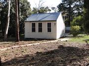
101 Carmel Rd Carmel
Heidelberg School
Scouts Meeting Hall
Kalamunda
Metropolitan
Constructed from 1923, Constructed from 1904
| Type | Status | Date | Documents |
|---|---|---|---|
| State Register | Registered | 05 Nov 1999 | HCWebsite.Listing+ListingDocument, HCWebsite.Listing+ListingDocument |
| Type | Status | Date | Documents |
|---|---|---|---|
| (no listings) |
| Type | Status | Date | Grading/Management | |
|---|---|---|---|---|
| Category | ||||
| Municipal Inventory | Adopted | 01 Aug 2013 | Category 1 | |
Carmel Primary School (fmr), a timber-framed, weatherboard and corrugated iron single-roomed school building (1904) and associated timber and corrugated iron shelter shed (1923) in a native bushland setting. The place is a rare example of a single roomed timber school building, located on its original site and in its original bushland setting, in the Perth metropolitan area.
| Name | Type | Year From | Year To |
|---|---|---|---|
| Public Works Department | Architect | - | - |
| Library Id | Title | Medium | Year Of Publication |
|---|---|---|---|
| 1172 | The changing face of Kalamunda : a collection of old and new photographs. Volume 2. | Book | 1987 |
Individual Building or Group
| Epoch | General | Specific |
|---|---|---|
| Original Use | EDUCATIONAL | Primary School |
| Present Use | SOCIAL\RECREATIONAL | Other |
| Type | General | Specific |
|---|---|---|
| Roof | METAL | Corrugated Iron |
| Wall | TIMBER | Weatherboard |
| General | Specific |
|---|---|
| SOCIAL & CIVIC ACTIVITIES | Education & science |
This information is provided voluntarily as a public service. The information provided is made available in good faith and is derived from sources believed to be reliable and accurate. However, the information is provided solely on the basis that readers will be responsible for making their own assessment of the matters discussed herein and are advised to verify all relevant representations, statements and information.
Constructed from 1904
The following statement is drawn from the Register Entry for the place used for its inclusion on the State Register of Heritage Places in 1999.
Very small single storey structure of timber framed construction with weatherboard cladding and a steep pitched roof clad in corrugated iron. The front elevation is dominated by three tall timber framed sash windows of 2-over-2 style. The roof is gabled in form with a lower sweep of the rear roof. The enclosed space incorporates a sash window matching the front windows whilst the rear section incorporates shallow high level windows. Further high level windows are inserted into the side (west) elevation. There are additional structures located around the site but the site is predominantly grassed with surrounding native vegetation. A flagstone pavements leads from the scout hall to Carmel Road incorporating the names and dates of the teachers of the school up to Margaret (Meg) Cooke, 1971.
Education, technology, sport and recreation, local heroes
Level of Integrity - High; Level of Authenticity - High
Good This former school building was constructed in 1904 to a standard design provided by the Public Works Department of WA. The builder, F. W. Box constructed the school building for £300. The school was built following requests to the Education Department from the local residents. In a report in the local press in 1903 it was stated that 15 to 20 children were in need of schooling in addition to 'youths' who would gladly attend night school. In 1905, the teachers quarters was built adjacent to the school room by builder M. MacKesy for £226 18s 8d. This building was again designed by the Public Works Department. During World War One the name of the school was changed to Carmel School in accordance with the policy which saw the name of the settlement Heidelberg removed from the public records. The school operated until 1990 and since that time has been used as a community resource. Currently [2013] the place is used as a scout hall.
| Ref ID No | Ref Name | Ref Source | Ref Date |
|---|---|---|---|
| "A Line on Kalamunda" | |||
| "Carmel Primary School 1904-1989". | Carmel Primary School P&C | 1989 |
| Reserve | Lot/Location | Plan/Diagram | Vol/Folio |
|---|---|---|---|
| Lot 101 | P109525 | LR3116-471 |
| Owner | Category |
|---|---|
| DOLA | State Gov't |
This information is provided voluntarily as a public service. The information provided is made available in good faith and is derived from sources believed to be reliable and accurate. However, the information is provided solely on the basis that readers will be responsible for making their own assessment of the matters discussed herein and are advised to verify all relevant representations, statements and information.
152 Carmel Rd Carmel
Kalamunda
Metropolitan
Constructed from 1940
| Type | Status | Date | Documents |
|---|---|---|---|
| (no listings) |
| Type | Status | Date | Documents |
|---|---|---|---|
| (no listings) |
| Type | Status | Date | Grading/Management | |
|---|---|---|---|---|
| Category | ||||
| Municipal Inventory | Adopted | 01 Aug 2013 | Category 4 | |
Individual Building or Group
| Epoch | General | Specific |
|---|---|---|
| Original Use | RELIGIOUS | Church, Cathedral or Chapel |
| Present Use | SOCIAL\RECREATIONAL | Other Community Hall\Centre |
| Type | General | Specific |
|---|---|---|
| Wall | ASBESTOS | Fibrous Cement, flat |
| Wall | ASBESTOS | Fibrous Cement, corrugated |
| General | Specific |
|---|---|
| SOCIAL & CIVIC ACTIVITIES | Religion |
This information is provided voluntarily as a public service. The information provided is made available in good faith and is derived from sources believed to be reliable and accurate. However, the information is provided solely on the basis that readers will be responsible for making their own assessment of the matters discussed herein and are advised to verify all relevant representations, statements and information.
Constructed from 1940, Constructed from 1950
· The place has social value for the members of the community who have attended the venue since its construction
Timber framed structure with fibre cement sheet cladding and stumped construction. A lower level entrance is constructed to the north elevation with a recent concrete and brick ramp addition. Gable roof with colorbond cladding. Windows are metal framed. Skillion roof shade structure projecting from the front elevation.
Technology, religion, sport and recreation
Level of Integrity - Low; Level of Authenticity - Moderate
Fair This hall was built by the Plymouth Brethren Community to provide a place for their regular meetings. The design and construction of the hall was undertaken by their members. The Plymouth Brethren had a strong community in the district until the 1960s. Since then the community transferred the ownership of the property to the Shire of Kalamunda and the hall provides for a range of community purposes.
| Reserve | Lot/Location | Plan/Diagram | Vol/Folio |
|---|---|---|---|
| Lot 23 | P202241 | 1539-687 |
| Owner | Category |
|---|---|
| Kalamunda Shire Council | Local Gov't |
This information is provided voluntarily as a public service. The information provided is made available in good faith and is derived from sources believed to be reliable and accurate. However, the information is provided solely on the basis that readers will be responsible for making their own assessment of the matters discussed herein and are advised to verify all relevant representations, statements and information.
26 Carmel Rd Carmel
Kalamunda
Metropolitan
Constructed from 1920
| Type | Status | Date | Documents |
|---|---|---|---|
| (no listings) |
| Type | Status | Date | Documents |
|---|---|---|---|
| (no listings) |
| Type | Status | Date | Grading/Management | |
|---|---|---|---|---|
| Category | ||||
| (no listings) | ||||
Individual Building or Group
| Epoch | General | Specific |
|---|---|---|
| Original Use | RESIDENTIAL | Single storey residence |
| Present Use | RESIDENTIAL | Single storey residence |
| Type | General | Specific |
|---|---|---|
| Wall | TIMBER | Weatherboard |
| Roof | METAL | Corrugated Iron |
| General | Specific |
|---|---|
| OCCUPATIONS | Rural industry & market gardening |
This information is provided voluntarily as a public service. The information provided is made available in good faith and is derived from sources believed to be reliable and accurate. However, the information is provided solely on the basis that readers will be responsible for making their own assessment of the matters discussed herein and are advised to verify all relevant representations, statements and information.
52 Carmel Rd Carmel
Kalamunda
Metropolitan
Constructed from 1900
| Type | Status | Date | Documents |
|---|---|---|---|
| (no listings) |
| Type | Status | Date | Documents |
|---|---|---|---|
| (no listings) |
| Type | Status | Date | Grading/Management | |
|---|---|---|---|---|
| Category | ||||
| (no listings) | ||||
Individual Building or Group
| Epoch | General | Specific |
|---|---|---|
| Present Use | RESIDENTIAL | Single storey residence |
| Other Use | Transport\Communications | Comms: Post or Telegraph Office |
| Original Use | RESIDENTIAL | Single storey residence |
| Type | General | Specific |
|---|---|---|
| Wall | TIMBER | Weatherboard |
| Roof | METAL | Corrugated Iron |
| General | Specific |
|---|---|
| TRANSPORT & COMMUNICATIONS | Mail services |
This information is provided voluntarily as a public service. The information provided is made available in good faith and is derived from sources believed to be reliable and accurate. However, the information is provided solely on the basis that readers will be responsible for making their own assessment of the matters discussed herein and are advised to verify all relevant representations, statements and information.
60 Carmel Rd Carmel
Rutherglen
Kalamunda
Metropolitan
Constructed from 1910
| Type | Status | Date | Documents |
|---|---|---|---|
| (no listings) |
| Type | Status | Date | Documents |
|---|---|---|---|
| (no listings) |
| Type | Status | Date | Grading/Management | |
|---|---|---|---|---|
| Category | ||||
| Municipal Inventory | Adopted | 01 Aug 2013 | Category 4 | |
Individual Building or Group
| Epoch | General | Specific |
|---|---|---|
| Present Use | RESIDENTIAL | Two storey residence |
| Other Use | Transport\Communications | Comms: Post or Telegraph Office |
| Original Use | RESIDENTIAL | Two storey residence |
| Type | General | Specific |
|---|---|---|
| Wall | TIMBER | Weatherboard |
| Roof | METAL | Corrugated Iron |
| General | Specific |
|---|---|
| TRANSPORT & COMMUNICATIONS | Mail services |
This information is provided voluntarily as a public service. The information provided is made available in good faith and is derived from sources believed to be reliable and accurate. However, the information is provided solely on the basis that readers will be responsible for making their own assessment of the matters discussed herein and are advised to verify all relevant representations, statements and information.
Constructed from 1910
· The place has historic value for its association with the provision of postal services in remote communities · The place has social value as a meeting place for the community when it served as the post office
Predominantly single storey timber framed building with weatherboard cladding and a gabled roof. The building is single storey to the street elevation and two storeys to the rear overlooking the valley. The dwelling is set below road level with timber framed sash windows, single glazed and timber door with small skillion canopy supported on timber brackets and columns. The main roof extends out to the side elevation creating the verandah area. To the rear, there is a double height elevation with balcony. The house has been much extended utilising similar construction details to the original section.
Mail services, orchards
Level of Integrity - None; Level of Authenticity - Moderate
Good This residence was used as the local post office for the Carmel District in the period 1915-1920. At this time the location was known as 'Green's Siding". The post office was managed by the resident of the house Mr C. A. Ingram from a small office located on the verandah of the house. The property was later acquired by William and Vera Roberts who continued to operate the property as an orchard and named the property 'Rutherglen'. The property is currently [2013] used as a winery and has undergone major alterations and additions.
| Ref ID No | Ref Name | Ref Source | Ref Date |
|---|---|---|---|
| Lewis J; "A History of Post Office int he Kalamunda Area". | Bill Shaw Award entry, | 1982 |
| Reserve | Lot/Location | Plan/Diagram | Vol/Folio |
|---|---|---|---|
| Lot 268 | P250047 | 1670-548 |
This information is provided voluntarily as a public service. The information provided is made available in good faith and is derived from sources believed to be reliable and accurate. However, the information is provided solely on the basis that readers will be responsible for making their own assessment of the matters discussed herein and are advised to verify all relevant representations, statements and information.
210 Glenisla Rd Carmel
WA Missionary College
Kalamunda
Metropolitan
Constructed from 1906
| Type | Status | Date | Documents |
|---|---|---|---|
| (no listings) |
| Type | Status | Date | Documents |
|---|---|---|---|
| (no listings) |
| Type | Status | Date | Grading/Management | |
|---|---|---|---|---|
| Category | ||||
| Municipal Inventory | Adopted | 21 Jul 1997 | Category 4 | |
| Library Id | Title | Medium | Year Of Publication |
|---|---|---|---|
| 1172 | The changing face of Kalamunda : a collection of old and new photographs. Volume 2. | Book | 1987 |
Individual Building or Group
| Epoch | General | Specific |
|---|---|---|
| Original Use | EDUCATIONAL | Combined School |
| Present Use | EDUCATIONAL | Combined School |
| Type | General | Specific |
|---|---|---|
| Wall | BRICK | Common Brick |
| Roof | TILE | Cement Tile |
| General | Specific |
|---|---|
| SOCIAL & CIVIC ACTIVITIES | Education & science |
This information is provided voluntarily as a public service. The information provided is made available in good faith and is derived from sources believed to be reliable and accurate. However, the information is provided solely on the basis that readers will be responsible for making their own assessment of the matters discussed herein and are advised to verify all relevant representations, statements and information.
Constructed from 1986
Opened by a layman. Though there was always a chapel on the site, this church is open to the public. Reinforces religious presence on site.
Light brick, with front porch with pillars. Colorbond roof rises to mock bell tower with small steeple of different green. Paved path all round. Plain glass windows, with padded benches. Lectern, but no dais. Very attractive building. Fits into landscape
Religion, technology
Integrity: Good
Good
| Ref ID No | Ref Name | Ref Source | Ref Date |
|---|---|---|---|
| ALK, 1978;SDA archives - 291-7420 | SDA Archives |
| Owner | Category |
|---|---|
| Australian Conference Association Ltd | Church Property |
This information is provided voluntarily as a public service. The information provided is made available in good faith and is derived from sources believed to be reliable and accurate. However, the information is provided solely on the basis that readers will be responsible for making their own assessment of the matters discussed herein and are advised to verify all relevant representations, statements and information.
210 Glenisla Rd Carmel
Kalamunda
Metropolitan
Constructed from 1932 to 1960
| Type | Status | Date | Documents |
|---|---|---|---|
| (no listings) |
| Type | Status | Date | Documents |
|---|---|---|---|
| RHP - To be assessed | Current | 09 May 2003 |
| Type | Status | Date | Grading/Management | |
|---|---|---|---|---|
| Category | ||||
| (no listings) | ||||
10417 Carmel Adventist College, Orchard, Packing Shed & Chapel
The place has associations with the Sanitarium Health Food Factory and has operated as a factory for this company from 1932 to 2003.
The place appears to be one of only a few industrial sites in the Carmel area, in particular those associated with the manufacture of food.
The place is representative of an industrial group of buildings built during the 1930s in the Inter War Stripped Classical style.
This has significance to the people who have worked there from 1932 up to the present day.
The site comprises a factory and office. The factory is located at the rear of the property (western end). It is a brick industrial building with a sawtooth CGI roof. The sawtooth roofed portion of the building was built in 1960. To Glenisla Road is the brick office, which is designed in the Inter War Stripped Classical style.
The factory and associated office was constructed in Carmel for the Sanitarium Health Food Company in 1932. Designed by engineers, Harry Tempest and W. George Thrift, the purpose of the factory was the manufacture of wheat flake biscuits. Sanitarium products had actually been available for sale in WA since the turn of the twentieth century. The factory was extended in 1932 to incorporate two mills and an additional cooker. Later, a ramp was built next to the railway line to allow deliveries of bulk wheat directly from train to truck, and in 1960 the factory was extended. In 2003, the factory is still in operation.
High
Good
| Name | Type | Year From | Year To |
|---|---|---|---|
| Harry Tempest & W George Thrift | Architect | - | - |
Individual Building or Group
| Epoch | General | Specific |
|---|---|---|
| Present Use | INDUSTRIAL\MANUFACTURING | Other |
| Original Use | INDUSTRIAL\MANUFACTURING | Other |
| Style |
|---|
| Inter-War Stripped Classical |
| Type | General | Specific |
|---|---|---|
| Roof | METAL | Corrugated Iron |
| Wall | BRICK | Common Brick |
| General | Specific |
|---|---|
| OCCUPATIONS | Manufacturing & processing |
This information is provided voluntarily as a public service. The information provided is made available in good faith and is derived from sources believed to be reliable and accurate. However, the information is provided solely on the basis that readers will be responsible for making their own assessment of the matters discussed herein and are advised to verify all relevant representations, statements and information.
211 Glenisla Rd Carmel
halfway down east slope of hill behind od carmel college dairy
Kalamunda
Metropolitan
Constructed from 1909
| Type | Status | Date | Documents |
|---|---|---|---|
| (no listings) |
| Type | Status | Date | Documents |
|---|---|---|---|
| (no listings) |
| Type | Status | Date | Grading/Management | |
|---|---|---|---|---|
| Category | ||||
| (no listings) | ||||
Historic Site
| Epoch | General | Specific |
|---|---|---|
| Original Use | VACANT\UNUSED | Vacant\Unused |
| Present Use | MONUMENT\CEMETERY | Grave |
| Type | General | Specific |
|---|---|---|
| Other | STONE | Marble |
| General | Specific |
|---|---|
| DEMOGRAPHIC SETTLEMENT & MOBILITY | Settlements |
This information is provided voluntarily as a public service. The information provided is made available in good faith and is derived from sources believed to be reliable and accurate. However, the information is provided solely on the basis that readers will be responsible for making their own assessment of the matters discussed herein and are advised to verify all relevant representations, statements and information.
Masonmill Rd Carmel
Kalamunda
Metropolitan
Constructed from 1891
| Type | Status | Date | Documents |
|---|---|---|---|
| State Register | Registered | 07 Dec 2007 | HCWebsite.Listing+ListingDocument, HCWebsite.Listing+ListingDocument |
| Type | Status | Date | Documents |
|---|---|---|---|
| (no listings) |
| Type | Status | Date | Grading/Management | |
|---|---|---|---|---|
| Category | ||||
| Municipal Inventory | Adopted | 01 Aug 2013 | Category 1 | |
Victoria Reservoir (fmr) is in fair condition. Structurally, the concrete in the dam is of poor quality and has a history of leakage. In 1988 the Water Authority decided that the dam did not have acceptable levels of safety under modern design criteria for flood and earthquake loadings. The concrete in the dam was of such poor quality that the dam could not be adequately rehabilitated. Nevertheless the remains of the dam and its surrounding setting are well maintained.
| Library Id | Title | Medium | Year Of Publication |
|---|---|---|---|
| 7592 | Mason & Bird Heritage Trail : retracing one of Western Australia's oldest timber routes. | Brochure | 1988 |
| 9984 | Perth's early water supplies. Australian Heritage Engineering Record. | Book | 1984 |
Historic site
| Epoch | General | Specific |
|---|---|---|
| Present Use | GOVERNMENTAL | Reservoir or Dam |
| Original Use | GOVERNMENTAL | Reservoir or Dam |
| Style |
|---|
| Other Style |
| Type | General | Specific |
|---|---|---|
| Wall | CONCRETE | Other Concrete |
| General | Specific |
|---|---|
| SOCIAL & CIVIC ACTIVITIES | Community services & utilities |
| OUTSIDE INFLUENCES | Water, power, major t'port routes |
This information is provided voluntarily as a public service. The information provided is made available in good faith and is derived from sources believed to be reliable and accurate. However, the information is provided solely on the basis that readers will be responsible for making their own assessment of the matters discussed herein and are advised to verify all relevant representations, statements and information.
Constructed from 1891
The present dam was constructed in the early 1900s, just upstream from the original dam on the Darling Scarp. The new dam was the first to use roller compact concrete in its construction. Today the dam sits within National Park with walkways to the dam, around it and across the high retaining wall. The remaining section of the original dam is lower down the scarp close to the processing plant.
Water storage schemes, technology 1891 (orig. dam) 1991 (new dam)
Level of Integrity - High; Level of Authenticity - High
Good Victoria Reservoir was completed in 1891 and was Perth’s first permanent public water supply. The demand for a reliable water source became more imperative following the completion of the Zig Zag railway line to the hills in 1891. The reservoir was constructed by private contractor Edward Keane in association with Melbourne based firm Neil McNeil and Co. The fully arched gravity wall construction was built by manual labour and opened in October 1891 by a party of dignitaries led by Alexander Forrest, Mayor of Perth. Mrs Lila Keane, wife of Edward Keane, turned the valve to supply Perth with its reticulated water. Almost immediately there were problems with the quality and quantity of water from the Victoria Reservoir. Problems that were exacerbated by the increasing population in Perth as a result of the gold boom of the 1890s. The dam structure was repaired in 1912 and in 1939 the right spillway was closed off. Major renovations were undertaken in 1966 but the quality and size of the dam wall construction led to the decision in 1989 to replace the dam wall. The first water was stored in the new Victoria Dam during the 1991 winter, the system coming ‘on-line’ in November 1991. A plaque on the site records an official opening by the Minister for Water Resources, Ernie Bridge, MLA, on 22 November 1991. Also in attendance was Victoria Williams, the great-great-grand- daughter of Lila Keane, who performed the original opening ceremony in 1891. The remnants of the original wall are still in situ approximately 500 metres downstream of the new dam wall.
| Ref ID No | Ref Name | Ref Source | Ref Date |
|---|---|---|---|
| ALK, p.44; | |||
| LSC No.s: 304, 1025, 1026, 1073; | Photographs | WA Water Coproration | |
| LSC - pamphletts |
| Reserve | Lot/Location | Plan/Diagram | Vol/Folio |
|---|---|---|---|
| Lot 3071 | R47881 | Various |
| Owner | Category |
|---|---|
| Water Corporation | State Gov't |
This information is provided voluntarily as a public service. The information provided is made available in good faith and is derived from sources believed to be reliable and accurate. However, the information is provided solely on the basis that readers will be responsible for making their own assessment of the matters discussed herein and are advised to verify all relevant representations, statements and information.
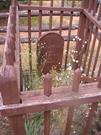
20 Masonmill Rd Carmel
On the WAWA access road to the Victoria Reservoir, sth of mason's mill. GPS co-ordinates are noted as 41247E, 6455716N but no datum was supplied.
Kalamunda
Metropolitan
Constructed from 1960, Constructed from 1876
| Type | Status | Date | Documents |
|---|---|---|---|
| State Register | Registered | 09 Oct 2009 | HCWebsite.Listing+ListingDocument, HCWebsite.Listing+ListingDocument |
| Type | Status | Date | Documents |
|---|---|---|---|
| (no listings) |
| Type | Status | Date | Grading/Management | |
|---|---|---|---|---|
| Category | ||||
| Municipal Inventory | Adopted | 01 Aug 2013 | Category 1 | |
Weston Grave, Carmel is in good condition as a result of regular dedicated maintenance by the Weston family, spanning six generations. There is no evidence of termite or fire damage. At a site inspection in March 2008, one of the railings from the outer fence showed possible termite damage. However, the Weston family subsequently repaired this.
Historic site
| Epoch | General | Specific |
|---|---|---|
| Present Use | MONUMENT\CEMETERY | Grave |
| Original Use | MONUMENT\CEMETERY | Grave |
| Style |
|---|
| Other Style |
| Type | General | Specific |
|---|---|---|
| Other | TIMBER | Other Timber |
| General | Specific |
|---|---|
| DEMOGRAPHIC SETTLEMENT & MOBILITY | Workers {incl. Aboriginal, convict} |
| DEMOGRAPHIC SETTLEMENT & MOBILITY | Settlements |
This information is provided voluntarily as a public service. The information provided is made available in good faith and is derived from sources believed to be reliable and accurate. However, the information is provided solely on the basis that readers will be responsible for making their own assessment of the matters discussed herein and are advised to verify all relevant representations, statements and information.
Constructed from 1896
Well maintained gravestone and surroundings off Masonmill Road on the approach to Victoria Dam. The headstone is surrounded by timber fencing around the extent of the gravesite with the grave being further enclosed by bush timber fencing. The wider extent of the gravesite is enclosed by wire mesh fencing, enclosing native and introduced planting. A firebreak extends around the site separating it from the remainder the bushland.
Settlements, timber 19/1/1896
Level of Integrity - High; Level of Authenticity - High
Good Two day old Francis Weston died on 19th January 1876 and was buried at this site by parents Mary and Richard Weston. Richard Philip and Mary Christina Weston were the first of the Weston family to settle in this district in 1875. They lived at Carmel near Mason and Bird's Mill for two years. Richard was a wheelwright carpenter. He later became the first land holder of Pickering Brook taking up 250 acres below the present golf course, and established the "Springdale" orchard. He was a pioneer orchardist and mill owner and mill-worker in this area. Francis was the first born of eleven children, 8 of whom survived. As a carpenter, Richard Weston made the coffin, carved the headboard for the gravesite and the railings around the grave and thereafter regularly cleared around the gravesite to prevent it being destroyed by bushfire. When he moved to Pickering Brook, he rode there regularly to keep it in order and safe from fire, until he died in 1922. For the next forty years Gregory Weston, the seventh son of Richard and Mary's eleven children, also rode on horseback to maintain it. This tradition was continued by his son, Neil. Neil's two daughters Marilyn (Rollings) and Jill (Della Franca) and their children and grand-children are looking after it now [2013]. The outer railings of bush timber were installed in the 1960s by family members as a further preventative measure. The grave was included in the State Register of Heritage Places in 2009.
| Ref ID No | Ref Name | Ref Source | Ref Date |
|---|---|---|---|
| LSC No.s 289, 290, 361, 1011 | Photographs | ||
| McNamara, F; "Kalamunda of the Dreamtime", | Perth | 1961 | |
| CHF, Perth, | 1979 |
| Reserve | Lot/Location | Plan/Diagram | Vol/Folio |
|---|---|---|---|
| Lot 3071 | R47881, plan 36440 | SHO survey 10486 |
| Owner | Category |
|---|---|
| Water Corporation | State Gov't |
This information is provided voluntarily as a public service. The information provided is made available in good faith and is derived from sources believed to be reliable and accurate. However, the information is provided solely on the basis that readers will be responsible for making their own assessment of the matters discussed herein and are advised to verify all relevant representations, statements and information.
50 Masonmill Rd Carmel
bush on west edge of bickley brook, orig. extending into rose nursey land
Kalamunda
Metropolitan
Constructed from 1864
| Type | Status | Date | Documents |
|---|---|---|---|
| (no listings) |
| Type | Status | Date | Documents |
|---|---|---|---|
| (no listings) |
| Type | Status | Date | Grading/Management | |
|---|---|---|---|---|
| Category | ||||
| Municipal Inventory | Adopted | 01 Aug 2013 | ||
Historic Site
| Epoch | General | Specific |
|---|---|---|
| Original Use | FORESTRY | Timber Mill |
| Present Use | VACANT\UNUSED | Vacant\Unused |
| General | Specific |
|---|---|
| OCCUPATIONS | Timber industry |
This information is provided voluntarily as a public service. The information provided is made available in good faith and is derived from sources believed to be reliable and accurate. However, the information is provided solely on the basis that readers will be responsible for making their own assessment of the matters discussed herein and are advised to verify all relevant representations, statements and information.
Constructed from 1864
· The site has historic value for its association with the first industry in the hills district and the role it played in opening up the area to settlement.
An axle at the Rose Gardens on Masonmill Road is on display together with an interpretation panel are the only remnants of the Mill, there are no physical remains. The site of the former mill is regenerated forest and is the start of the Mason Bird Walk trail near the junction of Masonmill Road and the access road to the Victoria Reservoir.
Timber, road and rail transport, innovators, settlements
Level of Integrity - Little; Level of Authenticity - None
This site was the location of the mill and associated buildings established by Benjamin Mason, a merchant of Perth. In the early 1860s Mason established a timber station on the Canning River at Mason's Landing. Timber from the surrounding area was pit-sawn and then transported on flat-bottomed barges via the Canning and Swan Rivers to Fremantle or Perth. Realizing the limited potential that the area held compared to the thick stands of jarrah available in the Darling Range, Mason applied for a licence to cut timber near Bickley Brook, in what is today the suburb of Carmel. Upon obtaining his permit in 1864 Mason built his second timber mill, the Hills Station (also known as Mason's Mill). At one time the mill was a thriving concern, employing a total male workforce of 138 (1% of the male population of the state at the time), 40 horses and 80 bullocks. In 1876 it was reported that 'the timber yard at the Hill Station abounds with huge logs, and an average of 6 bullock teams are daily employed in hauling at the mill'. At the peak years of production the mill produced 20,000 feet of timber per day. Due to the number of accidents on the tramway, and other transportation problems which made the deliveries unreliable, the business of Mason, Bird and Co. was forced into bankruptcy in 1882. The machinery and building materials from the site were sold or reused and there is little evidence of the former structures on the site. Some elements have been collected and displayed at the nearby commercial Rose Nursery.
| Ref ID No | Ref Name | Ref Source | Ref Date |
|---|---|---|---|
| CHF Chapters 1 & 2. | |||
| "Employers of Ticket-of-Leave Men". | WABI records on microfilm, State Archives, |
| Reserve | Lot/Location | Plan/Diagram | Vol/Folio |
|---|---|---|---|
| Lot 312 | P300697 | 1953-566 |
| Owner | Category |
|---|---|
| Water Corporation | State Gov't |
This information is provided voluntarily as a public service. The information provided is made available in good faith and is derived from sources believed to be reliable and accurate. However, the information is provided solely on the basis that readers will be responsible for making their own assessment of the matters discussed herein and are advised to verify all relevant representations, statements and information.
75 Moffett Rd Carmel
Kalamunda
Metropolitan
Constructed from 1927
| Type | Status | Date | Documents |
|---|---|---|---|
| (no listings) |
| Type | Status | Date | Documents |
|---|---|---|---|
| (no listings) |
| Type | Status | Date | Grading/Management | |
|---|---|---|---|---|
| Category | ||||
| Municipal Inventory | Adopted | 01 Aug 2013 | Category 3 | |
Individual Building or Group
| Epoch | General | Specific |
|---|---|---|
| Present Use | RESIDENTIAL | Single storey residence |
| Original Use | RESIDENTIAL | Single storey residence |
| Type | General | Specific |
|---|---|---|
| Wall | TIMBER | Weatherboard |
| Roof | METAL | Corrugated Iron |
| General | Specific |
|---|---|
| PEOPLE | Early settlers |
This information is provided voluntarily as a public service. The information provided is made available in good faith and is derived from sources believed to be reliable and accurate. However, the information is provided solely on the basis that readers will be responsible for making their own assessment of the matters discussed herein and are advised to verify all relevant representations, statements and information.
Constructed from 1927
· The place has historic value for its association with one of the first settlers and orchardists in the district. · The place has aesthetic value as an expression of a simple weatherboard home built in the inter war period.
Single storey timber framed cottage with weatherboard and fibre cement sheet cladding. The roof is hipped in form, continuing down to form the verandah canopy albeit at a shallower angle than the main roof, both sections are clad with corrugated iron. Red brick chimneys. All windows are casements and metal framed. Two mature trees are located in front of the house.
Early settlers, orchards, technology
Level of Integrity - Moderate; Level of Authenticity - Moderate
Fair John Moffett (1882-1958) was born in Ireland and arrived in WA in 1910. In 1916, he bought this 25 acre property in Carmel and established an orchard. He worked first as a sleeper cutter and labourer for the Darling Range Road Board. The sleepers were used in the Zig Zag Railway. In 1925, he married Margaret Farr and they had two daughters but sadly Margaret died in 1929 aged only 25 years. John married Margaret's sister, Mary in 1931 and they had a son. The property is still associated with the Moffett family who were one of the first families in the district.
| Ref ID No | Ref Name | Ref Source | Ref Date |
|---|---|---|---|
| Wallis P; "Memories of Walliston", | 1992 |
| Reserve | Lot/Location | Plan/Diagram | Vol/Folio |
|---|---|---|---|
| Lot 344 | D86226 | 1995-800 |
This information is provided voluntarily as a public service. The information provided is made available in good faith and is derived from sources believed to be reliable and accurate. However, the information is provided solely on the basis that readers will be responsible for making their own assessment of the matters discussed herein and are advised to verify all relevant representations, statements and information.
29 Morton Rd Carmel
ruin on hillside
Kalamunda
Metropolitan
Constructed from 1906
| Type | Status | Date | Documents |
|---|---|---|---|
| (no listings) |
| Type | Status | Date | Documents |
|---|---|---|---|
| (no listings) |
| Type | Status | Date | Grading/Management | |
|---|---|---|---|---|
| Category | ||||
| Municipal Inventory | Adopted | 01 Aug 2013 | Category 4 | |
Individual Building or Group
| Epoch | General | Specific |
|---|---|---|
| Present Use | RESIDENTIAL | Single storey residence |
| Original Use | RESIDENTIAL | Single storey residence |
| Type | General | Specific |
|---|---|---|
| Roof | METAL | Corrugated Iron |
| Wall | TIMBER | Weatherboard |
| General | Specific |
|---|---|
| OCCUPATIONS | Domestic activities |
This information is provided voluntarily as a public service. The information provided is made available in good faith and is derived from sources believed to be reliable and accurate. However, the information is provided solely on the basis that readers will be responsible for making their own assessment of the matters discussed herein and are advised to verify all relevant representations, statements and information.
Constructed from 1906
· The place has historic value for its association with the early settlement of the district
Timber framed cottage with weatherboard and slab cladding. Gabled corrugated iron roof. Evidence of openings but no remnant doors or windows. Freestanding oven/chimney adjacent to the cottage of brick construction.
Early settlers, technology, domestic
Level of Integrity - Low; Level of Authenticity - Low
Poor This ruin is the remnant of the home built by Ernest John Mason (1875-1948). Ernest married Flora Jane Oysten (1880-1943) in 1897 and they had eight children. Ernest purchased this property and built a modest home on the site in 1906. He worked as a teamster in the Pickering Brook area and the couple lived in the area for all their married life. The portion of the building which remains is the kitchen which is believed to have been built by Flora Mason after the completion of the main body of the residence.
| Ref ID No | Ref Name | Ref Source | Ref Date |
|---|---|---|---|
| Mansfiled C; "Mum and the Kids'. | Australian Garden Journal. |
| Reserve | Lot/Location | Plan/Diagram | Vol/Folio |
|---|---|---|---|
| Lot 1 | D3593 | 1561-576 |
This information is provided voluntarily as a public service. The information provided is made available in good faith and is derived from sources believed to be reliable and accurate. However, the information is provided solely on the basis that readers will be responsible for making their own assessment of the matters discussed herein and are advised to verify all relevant representations, statements and information.
18 Union Rd Carmel
Kalamunda
Metropolitan
Constructed from 1922
| Type | Status | Date | Documents |
|---|---|---|---|
| (no listings) |
| Type | Status | Date | Documents |
|---|---|---|---|
| (no listings) |
| Type | Status | Date | Grading/Management | |
|---|---|---|---|---|
| Category | ||||
| Municipal Inventory | Adopted | 01 Aug 2013 | Category 3 | |
Individual Building or Group
| Epoch | General | Specific |
|---|---|---|
| Original Use | RESIDENTIAL | Single storey residence |
| Present Use | RESIDENTIAL | Single storey residence |
| Type | General | Specific |
|---|---|---|
| Wall | TIMBER | Weatherboard |
| General | Specific |
|---|---|
| DEMOGRAPHIC SETTLEMENT & MOBILITY | Land allocation & subdivision |
This information is provided voluntarily as a public service. The information provided is made available in good faith and is derived from sources believed to be reliable and accurate. However, the information is provided solely on the basis that readers will be responsible for making their own assessment of the matters discussed herein and are advised to verify all relevant representations, statements and information.
Constructed from 1922, Constructed from 1930
· The place has historic value for its association with early settlers in the Carmel district. · The place has historic value for its association with blacksmith Alexander Mitchell who practiced his trade at this site.
Double height timber framed shed with corrugated iron cladding to the walls and roof. The roof is single pitched with the rear elevation being higher than the front elevation. Two large entrances are positioned in the side and the street facing elevation. Concrete floor.
Land allocation, early settlers, orchards, nurseries, religion c.1930 (addition of 2ndhand cottage); 1976 (restoration from near derelict state)
Level of Integrity - Considerable; Level of Authenticity - Moderate
Fair Alexander and Kate Mitchell were married in 1913 and moved to Carmel in c1922 to take up this property. Alexander Mitchell practiced his trade as a blacksmith in the yard before building a smithy and garage. A basic cottage was built for the family and it has been added to over the years obscuring the original two rooms.
| Ref ID No | Ref Name | Ref Source | Ref Date |
|---|---|---|---|
| "Carmel Primary School 1904-1989". pp. 21, 22, 28. | Carmel P&.C, |
| Reserve | Lot/Location | Plan/Diagram | Vol/Folio |
|---|---|---|---|
| Lot 10 | P202203 | 211-51A |
This information is provided voluntarily as a public service. The information provided is made available in good faith and is derived from sources believed to be reliable and accurate. However, the information is provided solely on the basis that readers will be responsible for making their own assessment of the matters discussed herein and are advised to verify all relevant representations, statements and information.