Local Government
Kalgoorlie-Boulder
Region
Goldfields
118-120 Burt St Boulder
Cnr Brookman St
Kalgoorlie-Boulder
Goldfields
Constructed from 1908
| Type | Status | Date | Documents |
|---|---|---|---|
| State Register | Registered | 19 Aug 1994 | HCWebsite.Listing+ListingDocument, HCWebsite.Listing+ListingDocument |
| Type | Status | Date | Documents |
|---|---|---|---|
| (no listings) |
| Type | Status | Date | Grading/Management | |
|---|---|---|---|---|
| Category | ||||
| Municipal Inventory | Adopted | 09 Jul 2001 | Category 1 | |
| Classified by the National Trust | Classified | 19 Nov 1993 | ||
| Register of the National Estate | Permanent | 21 Mar 1978 | ||
00172 Burt Street Precinct
| Name | Type | Year From | Year To |
|---|---|---|---|
| A Oswold Wilson | Architect | - | - |
| Library Id | Title | Medium | Year Of Publication |
|---|---|---|---|
| 3419 | Goatcher Drop Curtain : conservation treatment report. | Report | 1997 |
| 9397 | Boulder Town Hall - final report | Conservation works report | 2009 |
| 9238 | Boulder Town Hall - final report. | Conservation works report | 2009 |
| 5591 | Boulder Town Hall (& fmr Council Chambers), cnr Burt and Brookman Streets, Boulder : conservation plan. | Heritage Study {Cons'n Plan} | 2002 |
| 10073 | Boulder Town Hall, cnr Burt and Brookman Streets, Boulder. | Heritage Study {Cons'n Plan} | 2012 |
| 5213 | Future use options for the Kalgoorlie & Boulder town halls : final report / APP Projects, Ferguson Architects & Ron Bodycoat on behalf of the City of Kalgoorlie-Boulder. | Report | 2001 |
Individual Building or Group
| Epoch | General | Specific |
|---|---|---|
| Original Use | GOVERNMENTAL | Town, Shire or District Hall |
| Present Use | GOVERNMENTAL | Town, Shire or District Hall |
| Style |
|---|
| Federation Free Classical |
| Type | General | Specific |
|---|---|---|
| Roof | METAL | Corrugated Iron |
| Wall | STONE | Local Stone |
| Wall | BRICK | Common Brick |
| General | Specific |
|---|---|
| SOCIAL & CIVIC ACTIVITIES | Government & politics |
This information is provided voluntarily as a public service. The information provided is made available in good faith and is derived from sources believed to be reliable and accurate. However, the information is provided solely on the basis that readers will be responsible for making their own assessment of the matters discussed herein and are advised to verify all relevant representations, statements and information.
Constructed from 1908
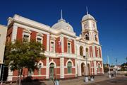
Boulder Town Hall has aesthetic value, being a notable example of the Gold Boom Federation Free Classical style in Western Australia. The imposing form of Boulder Town Hall, complete with tall clock tower prominently located at the intersection of Burt and Brookman Streets, has some significance as the focal point of Boulder township since 1908. The quality of the interior details, particularly the pressed metal proscenium arch and ceiling of the hall, is of some significance. The drop-curtain, painted by Phil W. Goatcher, is a rare surviving example of his artwork in Western Australia, adding to the aesthetic value of the hall interior. As an imposing and substantial public building, Boulder Town Hall has historic value as evidence of the prosperity experienced in the Eastern Goldfields at the turn of the century. The scale and stature of the building reflects the confidence of Boulder's civic leaders in the continued prosperity and growth of their town. Boulder Town Hall has social value as the administrative, civic and social centre of Boulder for over 80 years. Despite the town's administrative amalgamation with Kalgoorlie, the Boulder Town Hall's social role, and value, continues. Boulder Town Hall is representative of administrative and civic buildings constructed in West Australian towns due to the economic stimulus provided by the 1890s gold boom. Statement of Significance: Boulder Town Hall has cultural significance for the following reasons: - the place is an impressive example of an administrative and civic building designed in the Federation Free Classical style; - the Goatcher curtain, an important work of scenic art, is an integral part of the Town Hall's elaborately detailed interior; and, - the place has historic and social significance associated with the development of Boulder, a West Australian goldfields town.
Boulder Town Hall is an imposing brick and stone building with clock tower at street corner, comprising municipal offices and council chambers, library, town hall, and 8 dressing rooms. The hall stage measures 42' x 32' (13m x 9.8m). The lofty hall is 70' long, 55' wide and 32' high (21.5m x 17m x 9.8m). A gallery runs around the sides of the hall, which also has a mechanical sliding roof. The exuberant interior detailing of the building reflects the pride, confidence and new wealth of the goldfields community, as well as contemporary aesthetic values. The proscenium arch and the elaborately patterned ceiling, both fashioned in pressed metal, are impressive examples of the range of building materials available in Western Australia, as a result of the goldrush. Boulder Town Hall is an exemplar of the Federation Free Classical style of architecture: "Free classical was a style well suited to express the confidence that accompanied the dynamic growth of settlements in Western Australia following the discovery of gold at Coolgardie and Kalgoorlie. Buildings in this idiom erected in the 1890s and early 1900s in Perth, Fremantle and the goldfields towns convey the ebullient confidence of these boom years at a time when the eastern states were suffering from depression, drought and industrial unrest. Many architects from the eastern states moved to Western Australia at this time and played an important role in the establishment and development of its towns, cities and suburbs" (Apperly et al, 1989: 104-107). In 1988, the Shire of Boulder received $7,500 towards the restoration of the Town Hall. This work, carried out by Engineer G. J. Looten, included: steel strapping to the two most easterly walls, removal of tie bars from the southern section of a wall in the ladies toilet (which had been installed some years earlier in an unsuccessful attempt to stabilise this section of the building), and rendering and repainting of the affected walls (details of the restoration work, including photographs, are held on Heritage Council of WA file). Despite this restoration work to the walls, there is evidence of renewed movement in the stonework in a number of places This may be attributed to the daily blasting at the nearby open pit. There is also evidence of rising damp.
The following is an extract from a brochure prepared for the opening of the Hall on 23 June 1908: "Boulder Town Hall was constructed for the Boulder Municipal Council at a cost of £11,200 by Mr. Octavius Stubbs, of Perth, to the plans and specifications of Mr A. Oswold Wilson, of Boulder. The block of Buildings comprises Municipal Offices and Council Chambers, a Library (both public and subscription) and a Theatre, with an up-to-date modern stage. The Hall is 70 ft long by 55 ft wide, by 32 ft clear height from floor to ceiling. A large gallery runs right round the Hall, which is lofty and well ventilated, with numerous exits and escape doors. A mechanical sliding roof has been constructed, and this can be opened or closed as desired. The stage has been constructed with a view to the accommodation of the most modern scenery, the stage mechanism having been specially designed by Mr Black, Chief Mechanist at His Majesty's Theatre, Perth. The dimensions of the stage are 42 ft by 34 ft deep behind the proscenium walls, and 39 ft deep to the footlights. The stage has a clear height of 45 ft to the gridiron, and has the usual fly galleries on three sides, scene dock, stage loft, etc. The Drop Curtain, which is a scene of 'The Bay of Naples', and an exterior set scene, are by the well known scenic artists, Phil W. Goatcher & Son, of Perth". The lighting in the buildings was designed by Mr H. G. Alder, Manager of the Boulder Municipal Electric Light Station. A special feature was made of the Hall lighting, the stage being illuminated with 275 lights of 16 c.p. each. The foundation stone of Boulder Town Hall was laid by Phillip Collier, Esq., M.L.A., on 13 November 1907 (information held on Heritage Council of WA file). It was opened by the Governor, Admiral Sir Frederick Bedford on 23 June 1908 (Boulder's Hidden Secrets, 1993). Despite the glowing description, at the time of the tender there was some local resistance to the construction of the building. 'Even though the tender has been accepted certain of the ratepayers think that an injunction could be obtained to stop the new building from being proceeded with' (WAMBEJ, 31 August 1907: 20). However, by the time of completion, the opening of the Town Hall and Council Chambers was a cause for celebration in Boulder. 'Flags were flying from the principal business places, and lines of bunting were stretched across Burt-street from in front of the Race Club offices and from the Court Hotel and the Mechanics' Institute' (Kalgoorlie Miner, 24 June 1908: 2). A great number of ordinary citizens turned out to be involved in the opening of the hall. It had been noted with appreciation by the mayor that such interest had been shown. However, there was insufficient room inside the hall for all the people present to be included in the actual ceremony. The Governor was presented with a souvenir gold key, manufactured by Messrs. Mazzuchelli & Downes, bearing an inscription that recorded the details of the event. The presence of the Governor at the opening ceremony indicates the significance of the occasion and the importance of the building in the town's development. Once inside the building, '...the stage was decorated with pot plants, and looked very attractive...' the mayor stepped forward to address the gathering. In his speech he outlined the background events that led to the eventual construction of the Town Hall. 'He was very pleased to be able to say that the successful competitor was their local architect, Mr A.O. Wilson, which proved that not only did Boulder turn out good gold but good architects also' (Kalgoorlie Miner, 24 June 1908: 2). The workmanship of the contractor is reflected in a comment in Western Australian Mining, Building and Engineering Journal in September 1908, 'The erection of the Boulder Town Hall was carried out so well by the contractor, Mr O. Stubbs, that during the three months' period of maintenance practically nothing had to be done to the building' (WAMBEJ, 28 September 1908: 20). Once Boulder Town Hall had been officially declared open, the musical section of the function commenced. The festivities surrounding the opening of the Hall continued for a number of days with further musical performances being held at the Hall, including choral singing and culminating with a grand ball. Many celebrities have since performed at the Hall, including Dame Nellie Melba, Eileen Joyce, Peter Dawson, Joan Sutherland and Jill Periman. The wonderful acoustic properties of the hall have attracted many comments over the years (Boulder's Hidden Secrets, 1993). Following the amalgamation of the Kalgoorlie and Boulder Town Councils in 1989, there was a rationalisation of Council activities and subsequently the functions of Boulder Town Hall changed. The hall continues to be the focus of social and cultural activities within the community, however the former council offices are now used as an art gallery and exhibition space. A major feature of the building is the drop curtain, 'The Bay of Naples', painted by Phil W. Goatcher (1851 - c.1931), a scene painter of world renown. Goatcher arrived in Melbourne in 1867, aboard the Dover Castle, having apprenticed himself to a Liverpool shipping company. However, he took leave and walked to the Ballarat goldfields to join relatives. Finding little success he left Australia seeking employment in America and Britain. During the 1870s and 1880s, he acquired a considerable reputation in the USA as a scenic artist, his specialty being drop-curtains (painted canvas cloths lowered during a performance to mask scene changes) and drop scenes (painted cloths in lieu of flats). Goatcher returned to Australia in 1890, painting scenery for J. C. Williamson's theatrical productions in Melbourne, before moving to Western Australia in 1906, in search of a drier climate. Goatcher, with his son James, established a successful painting and decorating business in West Perth. The original subject of the Boulder curtain was the Rock of Gibraltar, however Goatcher subsequently altered it to the Bay of Naples to please the Italian goldfields community (Ivan King, HMT archivist, has a photograph of the original Gibraltar scenic curtain). The scenic curtain, an integral part of the internal decoration of Boulder Town Hall, is the only known example of Goatcher's scenic painting in Western Australia. Other examples of Goatcher's art are to be found in the chapel of St Gertrude's School, New Norcia, All Saints' Church, Collie and St John's Church, Fremantle (Hough, 1991: 98-99). The Insurance Plans for Boulder c. 1900 illustrate that Lot 888 had a Council Chambers building made of wood.
Integrity: High Authenticity: High
| Name | Type | Year From | Year To |
|---|---|---|---|
| A.O. Wilson | Architect | 1908 | - |
| Mr Black (stage) | Architect | - | - |
| Ref ID No | Ref Name | Ref Source | Ref Date |
|---|---|---|---|
| Hough, D; "‘Remembrance of Scenes Past’" | The Bulletin | 15 October.1991 | |
| "Boulder's Hidden Secrets Golden Footsteps – Join us for a Walk through Boulder as it was at the Turn of the Century". | Kalgoorlie | 1993 | |
| "Newspaper Article". p.2 | Kalgoorlie Miner | 24 June 1908 |
| Owner | Category |
|---|---|
| City of Kalgoorlie-Boulder | Local Gov't |
This information is provided voluntarily as a public service. The information provided is made available in good faith and is derived from sources believed to be reliable and accurate. However, the information is provided solely on the basis that readers will be responsible for making their own assessment of the matters discussed herein and are advised to verify all relevant representations, statements and information.
134 Burt St Boulder
Masonic Hall
Kalgoorlie-Boulder
Goldfields
Constructed from 1901
| Type | Status | Date | Documents |
|---|---|---|---|
| Heritage Agreement | YES | 24 Apr 2012 | HCWebsite.Listing+ListingDocument |
| State Register | Registered | 12 Dec 1997 | HCWebsite.Listing+ListingDocument, HCWebsite.Listing+ListingDocument |
| Type | Status | Date | Documents |
|---|---|---|---|
| (no listings) |
| Type | Status | Date | Grading/Management | |
|---|---|---|---|---|
| Category | ||||
| Municipal Inventory | Adopted | 09 Jul 2001 | Category 1 | |
| Classified by the National Trust | Classified | 06 Sep 1976 | ||
| Register of the National Estate | Permanent | 21 Mar 1978 | ||
| Library Id | Title | Medium | Year Of Publication |
|---|---|---|---|
| 5812 | Photographic record of the additions and caretakers dwelling at the rear of the Boulder Masonic Lodge, Burt Street, Boulder. | Report | 2002 |
| 9885 | Boulder Masonic Temple | Heritage Study {Cons'n Plan} | 2011 |
| 9977 | Boulder Masonic Lodge - adaptation. | Archival Record | 2012 |
Individual Building or Group
| Epoch | General | Specific |
|---|---|---|
| Present Use | SOCIAL\RECREATIONAL | Masonic Hall |
| Original Use | SOCIAL\RECREATIONAL | Masonic Hall |
| Style |
|---|
| Federation Academic Classical |
| Type | General | Specific |
|---|---|---|
| Roof | METAL | Corrugated Iron |
| Wall | BRICK | Common Brick |
| General | Specific |
|---|---|
| SOCIAL & CIVIC ACTIVITIES | Institutions |
This information is provided voluntarily as a public service. The information provided is made available in good faith and is derived from sources believed to be reliable and accurate. However, the information is provided solely on the basis that readers will be responsible for making their own assessment of the matters discussed herein and are advised to verify all relevant representations, statements and information.
Constructed from 1901, Constructed from 1902
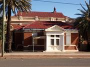
Assessment of Significance: Masonic Temple is typical of the Federation Academic Classical style of architecture common throughout the goldfields during the gold boom. The building with its moulded exterior enhanced by its central porch makes a contribution to the streetscape. Its streetscape value has been diminished by its front boundary fence. (Criterion 1.1) The construction of Masonic Temple is closely associated with the rapid population growth in the eastern goldfields at the turn-of-the-century. (Criterion 2.2) From the day of its opening, the place has been held in high regard by the local Masonic fraternity. Masonic Temple is representative of the Federation Academic Classical style built for modest sized public architecture. (Criterion 6.1) Statement of Significance: Masonic Temple, a single -storey Federation Academic Classical style brick building, has cultural heritage significance for the following reasons: - the place makes a contribution to the streetscape with its moulded exterior enhanced by its central porch; - the place is closely associated with the rapid population growth in the eastern goldfields at the turn-of-the-century; - the place is an expression of community wealth and prominence; and, - from the day of its opening, the place has been held in high regard by the local Masonic fraternity. A timber framed and corrugated-iron clad caretaker's quarters at the rear of the site is not included in this assessment.
Masonic Temple is a medium-sized building built in the Federation Academic Classical style (Apperly et al, 1989: 100-103) set back from the street alignment. This style was used to express community wealth and prominence and is common throughout the goldfields which grew and prospered following the discovery of gold in the early 1890s. The front elevation is framed by two established date palms and the building is surrounded by gravel. The exterior walls are constructed of red fair-faced bricks laid in Flemish bond on a small rendered plinth. The building has a projecting facade bay and a central porch which is a feature of the exterior. The building is symmetrical about a well proportioned porch. Although enclosed, the porch is reminiscent of a classical temple front with Tuscan columns at its front corners that sit on a rendered platform, and a Doric entablature with a triglyph and metope frieze. The porch is crowned with a triangular pediment featuring a painted 'T' square and compass, the emblem of the masons, set against a rendered background. Either side of the porch, the breakfront has rectangular windows, the panes of which are now painted over. The roof is hipped and covered with corrugated iron with metal roof vents and timber bracketed eaves. The height of the walls is broken by a rendered sill and string course. The sill course extends to the main wall. The projecting bay stands in front of the wall to the temple room. The wall is built in matching brickwork and is embellished with rendered decorative treatment. The wall has end pilasters, blind windows and a rendered parapet with an Italianate balustrade. The parapet conceals a hipped roof with vented gablets and two small lanterns. The blind windows have a semi-circular arched head, with decorative infill, supported on pilasters. A sheet metal fence added across the front boundary restricts visibility of the facade and diminishes its streetscape value. The interior of the porch features tessellated floor tiles, four leaded and stained glass windows with centre motifs, and a pressed metal ceiling. The timber panelled door is an addition. The interior of the building comprises a central hall with two ante-rooms on the west, and an ante-room and store room on the east. The hall leads to the main temple room, and a supper room behind. Entrance to the hall is through a doorway with a semi-circular fanlight, for which the glazing is now missing. The hall features an archway supported by square pilasters with a pronounced keystone and a moulded soffit, tall skirting boards, ceiling roses, and painted walls in blue hues to represent the blue lodgeship. Pressed metal ceilings and roses have been used to decorate the ante-rooms. The timber floorboards have been covered with carpet. The interior treatment of the temple room is highly elaborate. The metal ceiling is multi-coloured and heavily embossed with an ornate cornice and four large roses. Three pendant lights illuminate the central space which is covered by a patterned carpet. The centre pendant features the letter 'G' for God. The south wall is strengthened with brick piers with a double-hung sash window and awning fanlight between each pier. The windows are now boarded over and furnished with red velvet curtains. At the centre of the east wall is a small archway supported by square pilasters with capitals. The archway has been enclosed. A raised podium extends across the east wall. The podium is covered with a large black and white chequered patterned linoleum. An organ and carved timber furniture in a grand style for the master, past master, immediate post master, deacons, secretary, treasurer, wardens and inner guard add to the grandeur of the interior. The original entrance to the temple room was through double-doors at the end of the hall. The doors have been fixed shut and the new entrance is through an existing door in the ante-room on the west side of the hall. The walls of the supper room are also strengthened with engaged piers with a window in between, but lack the ornamentation of the temple room. All window panes have been covered. A storeroom has been added behind the temple room (date of the addition is unknown) and c.1990, a kitchen was added to the supper room. The timber framed additions are externally clad in corrugated iron and the kitchen is internally clad with fibro-cement linings. The additions are at a lower level to the original building. With the exception of rising damp, the building is in good condition. An apron of blue metal has been placed around the building against the exterior walls in an attempt to increase moisture soakage (discussion with Master Keith Edwards, 1 March 1996). Vandals have damaged the windows on the west elevation. At the rear of the site is a timber framed ripple-iron clad, single-storey caretaker's quarters. The building, which is in very poor condition, does not form part of this assessment.
Masonic Temple is a one-storey brick and iron building, constructed in 1901-02 to provide meeting facilities for the growing number of Freemasons in the Boulder area. On 27 February 1900, the Grand Lodge of Western Australia was "regularly formed, assembled and properly dedicated to the work of the Ancient, Free and Accepted Masonry …" (Grand Lodge of WA of Ancient, Free and Accepted Masons, 1950: 5). The formation of a Grand Lodge, local and supreme, marked the attainment of autonomous government in matters Masonic. The first Lodge in Western Australia had been established in 1843. Growth was slow, until the 1880s when progress started to became more rapid. The increase in the number of lodges reflects the more prosperous conditions prevailing in the colony. The first impact of the gold discoveries boom also hastened the movement to establish lodges in the older settled areas. By October 1899, there were 35 lodges in existence, owing allegiance to the Grand Lodge of England. Both the Kalgoorlie and Boulder Lodges were formed in 1897 (Grand Lodge of WA of Ancient, Free and Accepted Masons, 1950: 7). On Wednesday, 11 December 1901, the foundation stone for Masonic Temple was laid. Mr M. McKay Hopkins was the architect and Mr J.V. Miles the builder. The Western Argus noted the event: "On Wednesday December 11 1901, the foundation stone was laid by the Boulder Masonic Lodge. Visiting brethren from many centres were present in considerable numbers. The Most Worshipful, the Grand Master, the Hon. J.W. Hackett arrived from Perth and a procession was formed to march to the site. Unaffiliated brethren followed with the architect, Bro. M.M. Hopkins, next carrying plans of the hall. On arrival at the site the procession opened and allowed the Grand Lodge Officers to march between the files to the dais. ...Before lowering the [memorial] stone the Grand Secretary read the inscription: 'This stone was laid on December 11 A.L. 1901, by the Hon. J.W. Hackett, M.L.C., M.W.K.M., W.A. Freemasons. Frank Mitchell W.M.; Tobert Hay Sect; M.McKay Hopkins, Architect; J.V. Miles, Builder'. A phial containing a list of officials, copies of the Kalgoorlie Miner and Evening Star and coins of the realm were placed underneath the stone which was lowered and declared to be truly laid. Corn, wine and oil were then poured over it and the building was solemnly consecrated by the Grand Chaplain. The architect, Bro. Hopkins, presented his plans, and the M.W.G.M., after inspecting them, ordered him to proceed with the construction of the building without loss of time" (Western Argus, 17 December 1901: 18). In 1998, although membership is decreasing, Masonic Temple continues to be used for its original purpose. The Insurance Plans for Boulder c. 1900 illustrate that Lot 204 was occupied by the Masonic Hall.
Integrity: High Authenticity: High
Good
| Name | Type | Year From | Year To |
|---|---|---|---|
| M. Hopkins | Architect | 1901 | 1902 |
| Ref ID No | Ref Name | Ref Source | Ref Date |
|---|---|---|---|
| "Grand Lodge of Western Australia of Ancient, Free and Accepted Masons (1950) Golden Jubilee History 1900-1950, ". p.5,7 | Paterson Brokensha, Perth. | 1950 | |
| "Newspaper Article". p.18 | Western Argus | 17 December 1901 |
This information is provided voluntarily as a public service. The information provided is made available in good faith and is derived from sources believed to be reliable and accurate. However, the information is provided solely on the basis that readers will be responsible for making their own assessment of the matters discussed herein and are advised to verify all relevant representations, statements and information.
72 Burt St Boulder
Boulder Court House (fmr)
Kalgoorlie-Boulder
Goldfields
Constructed from 1898, Constructed from 1900, Constructed from 1905
| Type | Status | Date | Documents |
|---|---|---|---|
| State Register | Registered | 09 Oct 2009 | HCWebsite.Listing+ListingDocument, HCWebsite.Listing+ListingDocument |
| Type | Status | Date | Documents |
|---|---|---|---|
| (no listings) |
| Type | Status | Date | Grading/Management | |
|---|---|---|---|---|
| Category | ||||
| Municipal Inventory | Adopted | 09 Jul 2001 | Category 1 | |
| Register of the National Estate | Permanent | 21 Oct 1980 | ||
| Classified by the National Trust | Classified | 19 Jul 1977 | ||
00172 Burt Street Precinct
10(a) Importance in demonstrating the evolution or pattern of Western Australia’s history;
Together the timber-framed corrugated iron clad Boulder Police Station and Quarters and the substantial masonry Court House, demonstrate the evolution of civic buildings on the goldfields of Western Australia during the late nineteenth and early twentieth centuries, with temporary or insubstantial buildings typically replaced with permanent brick and stone structures as populations increased and towns developed (historic value).
Boulder Police Station, Quarters and Court House (fmr) demonstrates the development of Boulder and its subsequent population increase in the 1890s spurred on by the gold rush, which necessitated improved and permanent law enforcement and justice facilities to address growing crime, as well as other public offices (historic value).
Boulder Police Station, Quarters and Court House (fmr) reflects the work of the Public Works Department, namely John Grainger and Hillson Beasley, in providing public services throughout the state, in this case policing, justice and banking facilities and water supply to the eastern goldfields (historic value).
The Boulder Court House (fmr), with its 1905 extension to accommodate the Post Office Savings Bank, is associated with the provision of banking services in regional areas, and provided these services until c.2010, by which time it was known as the Commonwealth Bank. These additions are reflective of the Western Australian government practice of reusing and adapting civic buildings for other purposes (historic value).
Boulder Court House (fmr) is associated with the administration and maintenance of the Goldfields Water Supply in Boulder in the early twentieth century, a significant scheme that was of fundamental importance to the mining industry in the eastern goldfields (historic value).
10(b) Importance in demonstrating rare, uncommon or endangered aspects of Western Australia’s heritage;
Initially conceived as a temporary solution to law and order demands in Boulder, the former Boulder Police Station is a rare extant example of a c.1890s timber-framed police station building constructed by the Public Works Department as a standard transportable building designed with adaptations for the climatic conditions of the eastern goldfields (rarity value).
Together the timber-framed corrugated iron clad Boulder Police Station and Quarters and the substantial masonry Court House are a rare extant example of what was a once common progression from temporary timber or canvas structures to substantial brick or stone as populations increased and goldfields developed during the late nineteenth and early twentieth centuries (rarity vale).
10(c) Potential to yield information that will contribute to an understanding of Western Australia’s history;
Boulder Police Station, Quarters and Court House (fmr) has potential to contribute to a wider understanding of the operations of the justice system in regional Western Australia, particularly regarding the provision of law and order services in the goldfields (scientific value).
Boulder Police Station, Quarters and Court House (fmr) provides information on the development and use of standard plans for government buildings, including police and judicial facilities, by the Public Works Department across the state, with both being relatively intact examples of their type and in this case designed with consideration of the eastern goldfield’s climatic conditions (scientific value).
10(d) Its importance in demonstrating the characteristics of a broader class of places;
Boulder Police Station, Quarters and Court House (fmr) contains two key elements to maintain law and order in society and together represent the practices and physical elements that were established during the late nineteenth and early twentieth centuries in the eastern goldfields to address growing crime in the region, and the subsequent supply of other public services (historic value).
Boulder Police Station and Quarters (fmr) reflects the late nineteenth century practice of incorporating residential functions with public buildings, blending civic and residential scale architectural elements in a vernacular style (historic value).
10(e) Any strong or special meaning it may have for any group or community because of social, cultural or spiritual associations;
Boulder Police Station, Quarters and Court House (fmr) formed part of the civic centre in Boulder and delivered necessary facilities to residents, and as such provides a significant sense of place for the local and wider community (social value).
Boulder Police Station, Quarters and Court House (fmr) is still valued by the local community being used as a meeting space for a variety of community groups, including the Goldfields Brass Band and the Eastern Goldfields Prospector’s Association (social value).
10(f) Its importance in exhibiting particular aesthetic characteristics valued by any group or community;
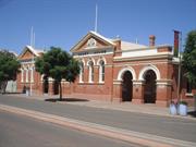
Boulder Court House (fmr) is a fine example of a government building in the Federation Free Classical architectural style. The building forms an integral part of Burt Street, the main commercial street in Boulder, and with its distinct architectural expression and picturesque arrangement of gables and arched arcades, contributes to the community’s sense of place (aesthetic value).
Boulder Police Station and Quarters (fmr) demonstrates an austere simplicity in its architectural scale and form and expresses a vernacular aesthetic which is quite common in regional Western Australia (aesthetic value).
10(g) Any special association it may have with the life or work of a person, group or organisation of importance in Western Australia’s history;
Boulder Police Station, Quarters and Court House (fmr) are both examples of the work of John Grainger and Hillson Beasley, who were members of a notable group of architects in the Public Works Department responsible for a significant number of public buildings in the 1890s and 1900s, during a period of unprecedented development in Western Australia (historic value).
The former Court House, with its 1905 Goldfields Water Supply office addition, is associated with the administration and maintenance of the Goldfields Water Supply Scheme, which was integral to the development of the eastern goldfields, as well as the development of agricultural areas and towns along the Scheme’s route. The Court House (fmr) is also associated with the operations of the Post Office Savings Bank, later becoming the Commonwealth Bank of Australia, from 1905 to c.2010 (historic value).
What is significant? Boulder Police Station, Quarters and Court House (fmr) is a discontiguous precinct comprising the single-storey timber and corrugated iron former Police Station and Quarters (1898) and the single-storey masonry and corrugated iron Federation Free Classical style former Court House (1900; 1905), both designed by the Public Works Department to provide law and order services in Boulder. Elements that contribute to the significance of the place include (but are not limited to): - The form and fabric of the Boulder Police Station and Quarters (fmr) comprising a single-sotrey vernacular building of timber-framed construction with corrugated iron cladding to the walls and roof (1898) - The form and fabric of the Boulder Court House (fmr) comprising the single-storey brick and stone Court House (1900) in the Federation Free Classical architectural style and brick former Goldfields Water Supply Office and Savings Bank additions (1905). The brick ablutions block (c.1961), timber-framed ancillary buildings (post-1963), pre-fabricated building extension (post-1963), contemporary fencing and gates, and peppercorn tree to the rear of the Boulder Court House do not contribute to the significance of the place. The infill cladding enclosing the rear verandah, steel-framed shed to the rear (c.2007), ablutions block (c.2007), and contemporary garrison fencing to the Boulder Police Station and Quarters, do not contribute to the significance of the place. How is it significant? The place is of historic, scientific, rarity, social and aesthetic value and satisfies the following factors relevant to cultural heritage significance: A. importance in demonstrating the evolution or pattern of Western Australia’s history; B. importance in demonstrating rare, uncommon or endangered aspects of Western Australia’s heritage; C. potential to yield information that will contribute to an understanding of Western Australia’s history; D. importance in demonstrating the characteristics of a broader class of places; E. strong or special meaning it has for any group or community because of social, cultural or spiritual associations; F. importance in exhibiting particular aesthetic characteristics valued by any group or community; G. special association it has with the life or work of a person, group or organisation of importance in Western Australia’s history. Why is it significant? Boulder Police Station, Quarters and Court House (fmr) is of historic and rarity value, demonstrating the evolution of civic buildings on the goldfields of Western Australia during the late nineteenth and early twentieth centuries, in which temporary or insubstantial buildings were usually replaced with permanent brick and stone structures as population increased. The place is an uncommon example of their type, representing these two phases of development (Factors A and B). The Police Station and Quarters has rarity value as an extant example of a c.1890s timber-framed police station designed by the Public Works Department as a standard transportable police station in the late nineteenth century, that included climatic adaptations suitable for the eastern goldfields (Factor B). Boulder Police Station, Quarters and Court House (fmr) is of historic value, representing the growth of Boulder and its subsequent population increase in the 1890s spurred on by the gold rush, which required improved and permanent law enforcement and justice facilities to address growing crime, along with other public offices, that were provided by the Public Works Department (Factors A and G). Boulder Police Station, Quarters and Court House (fmr) is of historic and scientific value, containing two key elements of maintaining law and order in society, and has the potential to contribute to a wider understanding of the operations of the justice system in regional Western Australia, particularly with regard to the provision of services established in the goldfields in the late nineteenth and early twentieth centuries (Factors C and D).
Boulder Police Station, Quarters and Court House (fmr) is a discontiguous precinct comprising a single-storey timber and corrugated iron former Police Station building (1898) and a single-storey steel-framed shed (c.2007); and a single-storey masonry and corrugated iron Federation Free Classical style Court House building (1900; 1905), and associated outbuildings including a brick ablutions block (c.1961), a prefabricated extension (post-1963), and a shed (post-1963).
Boulder Police Station & Quarters (fmr) is in fair-good condition, with evidence of ongoing care and maintenance to the place, but with deterioration as can be expected for a building of this age and construction type. Some of the window glazing is broken, but openings are protected with infill material to prevent weather ingress. Internally, the fabric is generally in good condition. Boulder Court House (fmr) is in fair-good condition. The building has some significant rising damp issues throughout, with fretting and damage to external render and face brickwork evident, as well as damage to internal plaster finishes and timber joinery affected by damp.
| Name | Type | Year From | Year To |
|---|---|---|---|
| Hillson Beasley | Architect | - | - |
| John Grainger | Architect | - | - |
| Library Id | Title | Medium | Year Of Publication |
|---|---|---|---|
| 2505 | Report on an assessment of cultural heritage significance and a conservation plan for the former Boulder Courthouse, Boulder, Western Australia. | Heritage Study {Cons'n Plan} | 1992 |
Individual Building or Group
| Epoch | General | Specific |
|---|---|---|
| Present Use | COMMERCIAL | Office or Administration Bldg |
| Original Use | GOVERNMENTAL | Courthouse |
| Present Use | COMMERCIAL | Bank |
| Style |
|---|
| Federation Free Classical |
| Type | General | Specific |
|---|---|---|
| Wall | STONE | Other Stone |
| Wall | BRICK | Common Brick |
| Roof | METAL | Corrugated Iron |
| General | Specific |
|---|---|
| SOCIAL & CIVIC ACTIVITIES | Community services & utilities |
| SOCIAL & CIVIC ACTIVITIES | Law & order |
| OUTSIDE INFLUENCES | Water, power, major t'port routes |
| Governing | Law, Order and Defence |
| DEMOGRAPHIC SETTLEMENT & MOBILITY | Settlements |
| Infrastructure | Development Settlements & Services |
| OCCUPATIONS | Mining {incl. mineral processing} |
| Economy | Mining and Mineral Resources |
| DEMOGRAPHIC SETTLEMENT & MOBILITY | Depression & boom |
This information is provided voluntarily as a public service. The information provided is made available in good faith and is derived from sources believed to be reliable and accurate. However, the information is provided solely on the basis that readers will be responsible for making their own assessment of the matters discussed herein and are advised to verify all relevant representations, statements and information.
Constructed from 1900
The place has intrinsic aesthetic characteristics, including aspects of the classical style that are of high aesthetic value. The building exhibits creative excellence and achievement through its beauty and proportions and the degree of unity of its materials, design and scale. The building makes a positive contribution to the significance of Burt Street. The building is an example of the Police court of its period illustrating the historic development of administration of the law in the State. The place has a strong association with the development of the Eastern Goldfields, in particular, the Eastern Goldfields Water Supply Scheme. The building has a relatively strong association with the historic personage, Warden J. M. Finnerty, and his notable jurisdiction in the Eastern Goldfields. The building is an important example of the work of a notable group of individually known architects of the Public Works Department whose works were of significant quality and influence within a critical phase of development of the State's culture. The building provides a notable example of a particular and significant architectural stylistic trend, ie. the free Classical style of the period, that distinguishes it from other such examples.
The main building incorporates a courtroom and associated offices constructed with random (ie. uncoursed) ashlar (ie. shaped stone) walls and timber-framed, corrugated galvanised iron clad roof, built in 1900, in the Federation Free Classical style. The building is enfolded and faced on all but the rear side with brick walled additions, built c. 1905. Arches and pediments in brick joined by a parapet were added in 1906, creating unity. The additions were built to house the Boulder branch offices of the State Bank and Eastern Goldfields Water Supply. The State Bank is a forerunner of present occupant, the Commonwealth Bank, and the courtroom and Water Supply offices now house community organisations. The site has an addition to the Bank and several detached outbuildings which are not included in this description of elements.
The Insurance Plans for Boulder c. 1900 illustrate that Lot 659 had two buildings constructed of brick. On the corner was the Post Office, and facing Burt Street was one building incorporating the Savings Bank (forerunner to the present Commonwealth Bank), the Court House and Goldfields Water Supply. There is no foundation stone as Government buildings were constructed by the Government Architect of the time.
Integrity: Moderate Authenticity: High
Good
| Name | Type | Year From | Year To |
|---|---|---|---|
| Hillson Beasley | Architect | 1900 | - |
| John Grainger PWD | Architect | 1900 | - |
| Owner | Category |
|---|---|
| Department of Planning & Infrastructure | State Gov't |
This information is provided voluntarily as a public service. The information provided is made available in good faith and is derived from sources believed to be reliable and accurate. However, the information is provided solely on the basis that readers will be responsible for making their own assessment of the matters discussed herein and are advised to verify all relevant representations, statements and information.
Lot 3603 Burt St Boulder
Reserve Details: No. 6662 (Railway) Certificate of Title (Volume / Folio): 3034 / 798
Subway Bridge
Kalgoorlie-Boulder
Goldfields
| Type | Status | Date | Documents |
|---|---|---|---|
| (no listings) |
| Type | Status | Date | Documents |
|---|---|---|---|
| (no listings) |
| Type | Status | Date | Grading/Management | |
|---|---|---|---|---|
| Category | ||||
| Municipal Inventory | Adopted | 09 Jul 2001 | Category 1 | |
04639 Boulder Railway Station, Subway & Loopline
Other Built Type
| Epoch | General | Specific |
|---|---|---|
| Present Use | Transport\Communications | Rail: Other |
| Original Use | Transport\Communications | Rail: Other |
| Type | General | Specific |
|---|---|---|
| Other | BRICK | Other Brick |
| Other | METAL | Other Metal |
| Other | METAL | Steel |
| General | Specific |
|---|---|
| TRANSPORT & COMMUNICATIONS | Rail & light rail transport |
This information is provided voluntarily as a public service. The information provided is made available in good faith and is derived from sources believed to be reliable and accurate. However, the information is provided solely on the basis that readers will be responsible for making their own assessment of the matters discussed herein and are advised to verify all relevant representations, statements and information.
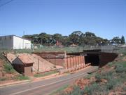
Assessment of Significance: Each element within the place (comprising the Boulder Railway Station, Subway and Loopline), is valued for its individual aesthetic characteristics, and together they form a significant group. (Criteria 1.1 & 1.3) The architectural features in the brick construction of the Boulder Subway walls are aesthetically pleasing. (Criterion 1.2) The places that comprise Boulder Railway Station, Subway and Loopline each have a landmark setting in the Boulder townsite or in the goldfields vista surrounding the town. Boulder Railway Station Building is a landmark associated with the approach drive, and the Rotunda is a pleasing element within the picturesque Park setting in front of Boulder Station. The Boulder Subway is a distinctive element in Boulder and is a marker between the town and the goldfields beyond. The war memorial by Porcelli is a fine example of his work. (Criterion 1.3) The places that make up Boulder Railway Station, Subway and Loopline represent a series of markers along the Loopline Railway line and provide a significant visual aesthetic and contribute to the cohesiveness of the cultural environment associated with the Loopline Railway. (Criterion 1.4) The construction and subsequent operation of Boulder Railway Station, Subway and Loopline was a result of the successful ongoing exploitation of the Eastern Goldfields, and in particular the Golden Mile. The Loopline operated between 1897 and 1976. (Criterion 2.1) Boulder Railway Station, Subway and Loopline provides a fine example of the transport infrastructure of the Eastern Goldfields during the 1880s and 1890s in Western Australia when large numbers of workers, heavy machinery, ore and timber had to be moved efficiently between mines, townships and transport depots. (Criteria 2.1 & 2.2) The Boulder Railway Station and Boulder Subway are representative of the growth of Boulder as the major residential and support and service centre of the Golden Mile mining tenements. (Criterion 2.2) The riveted plate bridge girder of the Boulder Subway demonstrates technical expertise in its construction. (Criterion 2.4) The riveted plate bridge girder construction of the Boulder Subway demonstrates technical expertise. It was built before the advent of modern welding techniques and is significant in representing steel fabrication techniques of the early 1900s. (Criterion 3.3) The structural competence and architectural achievement of the Boulder Subway, together with the central Pedestrian Subway to the roadway below and the railway above, is of considerable significance in demonstrating the expertise of the time in responding to transport requirements. (Criterion 3.3) Boulder Railway Station, Subway and Loopline is valued by the local and wider community for its ongoing railway associations, its connection with Boulder's gold boom past, and for its considerable aesthetic and landscape appeal. Its importance to the community is demonstrated by the formation of the Golden Mile Loopline Railway Society which operates the line as a tourist attraction, and by the occupation of Boulder Railway Station Building by the Goldfields Historical Society from 1976 to c. 1995. (Criterion 4.1) Boulder Railway Station, Subway and Loopline contributes to the local and wider community's sense of place as a significant reminder of the 1880s and 1890s goldrushes in Western Australia. (Criterion 4.2) The Boulder Subway provides the only known example in the State of a subway built to its particular specifications, in particular regarding length, the number of tracks and the roadway carried by the bridge. The use of brick faced parapet beams and semi-circular floor troughing is unique in Western Australia. (Criterion 5.1) The riveted girder construction, gravity brick abutments and retaining walls of Boulder Subway represent a nineteenth century form of construction that is now obsolete and is becoming increasingly rare in Western Australia as subways are gradually being replaced to meet town planning and railway requirements. (Criterion 5.2) Boulder Railway Station, Subway and Loopline, and associated elements which assist in understanding the place, represent a unique example of what was a typical turn of the century goldfields railway system. (Criterion 6.2) Statement of Significance: Boulder Subway has cultural heritage significance for the following reasons: - the place provides a fine remnant example of the transport infrastructure of the Eastern Goldfields during the 1880s and 1890s in Western Australia, when large numbers of workers, heavy machinery, ore and timber had to be moved efficiently between mines, townships and transport depots; - the construction of the place was a result of the successful exploitation of the Eastern Goldfields, and in particular the Golden Mile. The Loopline operated from 1897 to 1976; - Boulder Subway provides the only known example in the State of a subway built to its particular specifications and demonstrates technical expertise in the riveted plate bridge girder construction. The use of brick faced parapet beams and semi-circular floor troughing is unique in Western Australia; - the riveted girder construction, gravity brick abutments and retaining walls of Boulder Subway represent a nineteenth century form of construction that is now obsolete and becoming increasingly rare in Western Australia; - the place contributes to the local and wider community's sense of place as a significant reminder of the 1880s and 1890s goldrushes in Western Australia. It is also valued by the various groups interested in conserving and promoting Western Australia’s railway heritage; and, - the Boulder Railway Station and Boulder Subway illustrate the importance of Boulder city as a major residential, and support and service centre, of the Golden Mile mining tenements at the turn of the century.
Less than a few hundred metres north of the Boulder Railway Station, at the end of the platform, is the Boulder Subway. It is a complex structure with a brick Pedestrian Subway parallel with the railway lines, a road Subway in Burt Street, at right angles to the railway line, and seven railway lines over the top, of which only three are still operational. A vehicle crash rail has been installed adjacent to the footpath through the subway. The central Pedestrian Subway slopes down from the original island platform. It is a ramped open tunnel down to the Burt Street road level. The entire construction is a substantial series of brick gravity mass retaining walls laid in English bond. The Boulder Subway walls are also constructed in brick. There are fretting bricks in evidence, particularly on the north west facing wall, and efflorescence, on the north east wall of the Subway. The railway support is a riveted steel bridge. It is a series of steel plate girders with the rail and ballast supported by steel troughing on the plate girders. The deck is in two sections, one each side of the Pedestrian Subway access. The eastern section of the deck, approximately 15 metres long, originally carried a road. It is supported by rolled steel longitudinal girders. The west end which carried the railway is fabricated riveted plate girders with lighter steel, semi-circular troughing. Girders and rivets are in an advanced state of corrosion and the residual strength cannot be properly assessed without dismantling the bridge decks. Under the Subway, there is still evidence of the original tram connections fixed under the steel girders. Venting elements are also still in place in the brick walls. The brick pump house is still in situ on the east side of the Subway. The railway track is laid with rails of a size and shape especially provided for the WAGR (58lbs/yd WAR) and is in reasonable condition. This rail type has been obsolete for many years (Bruce James, Chairman, Heritage Panel, Institution of Engineers of Australia, correspondence to HCWA dated 24 November 1999 - HCWA File R4639. This rail was also used to construct the Kalgoorlie-Leonora Railway and a slightly modified rail was adopted as a WAGR standard for use in many parts of the system, including the Northam to Kalgoorlie Railway and the Norseman to Esperance section of the Esperance railway). The railway also features a number of timber box culverts in reasonable condition (Bruce James, Chairman, Heritage Panel, Institution of Engineers of Australia, correspondence to HCWA dated 24 November 1999 - HCWA File R4639. These were a WAGR standard in common use but have been fully replaced on operating railway lines). Comparative Information: The construction of the Boulder Subway is typical of WAGR subway construction of the time, but its length of approximately 75 metres makes it one of the longest, if not the longest, in the State. The rivet construction, gravity brick abutments and retaining walls of the Subway represent a nineteenth and early twentieth century form of construction that is now obsolete. Other examples are in the Perth metropolitan area, but these are gradually being replaced to meet the changing requirements of town planning and railway axle roads. For example, the Hay Street subway in Subiaco has recently been removed. The Subway is also unique in the use of brick faced parapeted beams and semi-circular floor troughing, rather than the usual trapesoidal shape (Bruce James, Chairman, Heritage Panel, Institution of Engineers of Australia, correspondence to HCWA dated 24 November 1999 - HCWA File R4639).
All the work on the Boulder Railway Station was completed by June 1903. Boulder Railway Station Buildings comprised the main Station Building (or station house; extant), the lamp room, and the latrines building (extant) on the 'up' platform, and a shelter house on the 'down' (island) platform. An overhead footbridge connected the two platforms just north of the main Station Building. Another footbridge south of the platforms provided access over all lines from the western (Boulder) side of the Station Reserve to the eastern (mines) side. The footing remains of the latter footbridge are extant. At the Burt Street (northern) end of the Station platforms, a road Subway allowed road traffic to pass under the railway line. A Pumping Station kept the Subway dry enough for traffic, and a Pedestrian Subway provided access from Burt Street up to the island platform with a connecting Underpass to the 'up' platform. There was another Underpass connecting the two platforms at the southern end of the station (plan of layout of Boulder Railway Station yard, CCE 4476; Eastern Goldfields Railway, Kalgoorlie Boulder Duplication, Boulder Station buildings plans, EEL Plan No. 5511, 1902, Drawings No. 2-6). The Stationmaster's house (extant) was constructed north of the Boulder Subway on a corner of the Station Reserve that was later annexed as Lot 3166 (Boulder City Station plan, EEL Plan No. 6957, 7 July 1909; Certificate of Title Vol. 3034, Fol. 798, 23 June 1993). The construction of the Boulder Subway divided the station yard in two. Originally, the Boulder Station yard had consisted of a single large wedge-shaped area on Hamilton Street between Forrest Street, at the southern end, and Wittenoom Street, at the northern end (Site plan of Boulder Station reserve prior to construction of Subway and existing station building, EEL Plan No. 6552). The Boulder Subway was designed to allow road traffic, particularly trams, to pass under the railway line. A tramway through the streets of Kalgoorlie and Boulder had been mooted as early as 1897, but the conflicting interests of Kalgoorlie Municipal Council, Kalgoorlie Roads Board, and Boulder Municipal Council, as well as the trade unions, brought delays. The Government was also concerned about a tramway competing with the Boulder Railway line. Nevertheless, Premier John Forrest believed that the difference in speeds and frequency of stops between a steam train and an electric street-car would make them complementary rather than competitive (Webb, 1993: 538). The first tramways were laid in Kalgoorlie in 1900, authorised by the Kalgoorlie Tramways Act of that year (Kalgoorlie Tramways Act 1900, 5 December 1900, Statute No. 43, 1900). The first trams ran on the Kalgoorlie lines on 2 May 1902 (Goldfields Magazine, 13 May 1993: 3). That year, the route was extended, and then duplicated in 1904 (Kalgoorlie Tramways Act, Amendment Act 1902, Statute No. 10, 1902, and Amendment Act 1904, Statute No. 5, 1904). The Boulder Municipal Council was slower in getting a tramway system in Boulder, hoping to encourage residents to patronise local commercial ventures rather than shop in Kalgoorlie. However, the fact that residents already had access to the Loopline to travel to Kalgoorlie made the argument redundant. The tramways were laid along Lane Street and through the Boulder Subway in 1903 and, in January 1904, the Boulder Tramways Act was passed (Boulder Tramways Act, 1904, Statute No. 2, 1904). Even before the tramway was running in Boulder, railway revenue was being effected by the competition, as reported in the Government Railways 1903 Annual Report. "During the year the competition with the Kalgoorlie Electric Tramway Co for the Boulder line traffic was keen, and caused shrinkage in our receipts for this line. Reduced fares and improved service gave satisfactory results, but only temporary. As soon as the electric trams run right into Boulder City our service will hardly pay" (Report on the workings of the Government Railway and the Roebourne-Cossack Tramway, June 1903, in Votes and Proceedings of the Parliament of WA, 1903, Paper No. 30: 18). The Railways department was correct in its forecast. From 1904, the Loopline began to lose money and services were curtailed, although it was claimed that the trains still ran every half hour, day and night (Webb, 1993: 538; Morris, 1984: 29-30). Trams ran along the main streets of both Kalgoorlie and Boulder, and through the Subway to the mines and the Boulder Block, which had developed as a commercial and recreational area in the heart of the mining tenements. While the Loopline may not have been profitable for the Government Railways, it was still a busy railway system. One of the requirements for operating the mines was timber, and from as early as 1898, timber companies, such as Millar Bros, leased land in the Boulder Station yard and constructed their own sidings. Timber for fuel was needed to generate electricity for lighting and power, to run the electric trams, to power the steam driven winders that hauled ore to the surface and to heat the furnaces in which the gold ore was roasted. Structural timber was also required for the shafts and passageways of the underground mines. Before the advent of the Goldfields Pipeline, water was condensed for drinking and for use in the steam train boilers, again requiring large supplies of timber. After the Goldfields Pipeline was completed between Mundaring and Kalgoorlie, timber was needed to fuel the eight steam-powered pumping stations along the pipeline route (Gunzberg and Austin, 1997: 163). After 1919, a number of companies involved in wood collecting operations concentrated on the area south of Lakeside, and Kamballie was the main depot where the wood wagons were left for distribution by WAGR to the mines and other users on the Loopline. The wood companies built 'woodlines' (railway tracks into the bush), moving them to a new area when the current area was cut out. Wood was cut in the area until about 1964, when diesel power began to take over (Gunzberg and Austin, 1997: Chapter 9). A 1952 map shows sidings from Boulder Station to the wood stacks at the Kalgoorlie Power Corporation site at the end of Hamilton Street (WAGR, Kalgoorlie Power Corporation sidings, Plan No. 41148, 1952). As well as transporting timber, and goods and machinery to the mines, and ore to Fremantle, the trains on the Loopline were used by the miners. The changing of the shifts saw thousands of men transported back and forth within a short space of time, with trains passing through Boulder Railway Station every few minutes at change of shift. Sixty trains, each up to ten carriages in length, provided the service (Uhe, 1994). Children travelling to Sunday School picnics at Lakeside were carried on a special train that ran around the Loopline collecting passengers on the way. Another benefit of the Loopline was felt by courting couples, who could catch the 8.30pm train at Boulder Railway Station, travel the Loop in comfort and in the dim light of the oil lamps, and be home by 10pm (Morris, 1984: 29-30). Passenger services on the Brown Hill Loop were discontinued in 1931, after all the houses in the area had either been dismantled or abandoned due to the Depression. The section closed completely in 1937. This left the Boulder City Loop and the mines line still operating. In 1952 the trams were replaced by buses, and by 1954 the rail service on the remaining Loopline was reduced to two passenger trains a day to Boulder and a goods train to Kamballie (Uhe, 1994). West Australian Government Railways had always had the problem of running a narrow gauge rail system while the rest of the rail link with the eastern states was standard gauge. The two systems met at Parkeston, 4 kms east of Kalgoorlie, where everything had to be manually transferred from one system to the other. In 1966, the standard gauge line was finally extended to Fremantle, and the narrow gauge system was phased out. The Loopline Railway was narrow gauge. Although emphasis was shifting to road transport, considered to more efficient than the railway as it reduced handling time and costs, Westrail did not cease operation of the Loopline until 1976. The Loopline Preservation Group was formed to retain the line and the remaining stations, and the Golden Mile Loopline Railway Society arranged to lease the line from Westrail to run as a tourist operation. In the late 1980s, new mining technology resulted in the development of the Super Pit open-cut mining operation. Since 1989, the Super-Pit operation has spread to the extent where very little remains of the Loopline. The original lease of the Loopline extended from Golden Gate to Trafalgar station, the next station on the line past Kamballie, but the operable section of line has since been reduced to that between Golden Gate and Kamballie (Westrail/Golden Mile Loopline Railway Society Lease, 1982). In April 1996, Westrail commissioned a structural investigation of the Boulder Subway, with a view to extending the operating life of the two tracks operated by the Loopline Railway Society (BSD Consultants, 1996). In 1999, the Golden Mile Loopline Railway Society, the Kalgoorlie-Boulder City Council and Kalgoorlie Consolidated Gold mines Pty Ltd began working on a ‘Loopline Heritage Restoration Project Plan’. The plan is considered imperative to the Loopline remaining a viable operation and to improve the facilities it provides as a tourist attraction in Kalgoorlie-Boulder. The central focus of the plan aims to recreate an important original aspect of the Loopline; ie. a rail connection between Boulder Station and Hannan Street (Presentation to Development Committee on 22 February 2000 - HCWA File P 4639). The Golden Mile Loopline Railway Society and Kalgoorlie Consolidated Gold Mines signed the agreement for the Loopline Heritage Restoration Project on 30 March 2000 (Kalgoorlie Miner, 31 March 2000: 3). Kalgoorlie Consolidated Gold Mines are funding the $1.5 million project in return for the removal of a section of the line that traverses part of a planned open cut mining area. The funding will go towards a loopline trust, restoration works to Boulder Subway and Station and future construction programs (Kalgoorlie Miner, 31 March 2000: 3). In 2000, the Boulder Station Buildings are occupied solely by the Golden Mile Loopline Railway Society, from which they run their tourist operation. The Society has recently constructed a shed for the use of restoring railway rolling stock. Their current lease on the Loopline buildings and line runs until 2003.
Integrity: Moderate to High Authenticity: High
Poor
| Ref ID No | Ref Name | Ref Source | Ref Date |
|---|---|---|---|
| Plan No. 41148 | Kalgoorlie Power Corporation sidings | WAGR | 1952 |
| Owner | Category |
|---|---|
| Westrail | State Gov't |
This information is provided voluntarily as a public service. The information provided is made available in good faith and is derived from sources believed to be reliable and accurate. However, the information is provided solely on the basis that readers will be responsible for making their own assessment of the matters discussed herein and are advised to verify all relevant representations, statements and information.
Hamilton St Boulder
Boulder Lot 2665 REGISTERED AS PART OF 4639 ALSO PART OF 172
Kalgoorlie-Boulder
Goldfields
Constructed from 1946
| Type | Status | Date | Documents |
|---|---|---|---|
| (no listings) |
| Type | Status | Date | Documents |
|---|---|---|---|
| RHP - Does not warrant assessment | Current | 19 Dec 2002 |
| Type | Status | Date | Grading/Management | |
|---|---|---|---|---|
| Category | ||||
| (no listings) | ||||
04639 Boulder Railway Station, Subway & Loopline
Corrugated iron roof and walls with a small front porch with a pitched gable roof. Internal timber floors, walls and ceilings of plasterboard; internal cladding contains asbestos. The place was demolished in about 2003.
Originally built by R.A.A.F at Boulder Aerodrome, it was later purchased by the CWA for $460.00 relocated. It officially repopened as the CWA Hall on 14 May 1947. It continued to be used by CWA until about 2002.
Individual Building or Group
| Epoch | General | Specific |
|---|---|---|
| Present Use | Transport\Communications | Air: Other |
| Original Use | Transport\Communications | Air: Other |
| SOCIAL\RECREATIONAL | CWA Hall |
This information is provided voluntarily as a public service. The information provided is made available in good faith and is derived from sources believed to be reliable and accurate. However, the information is provided solely on the basis that readers will be responsible for making their own assessment of the matters discussed herein and are advised to verify all relevant representations, statements and information.
Hamilton St Boulder
Address includes: Lot 561 Hamilton St, Boulder. Includes: Section of Loopline Railway Line, Boulder Station Goods Shed, Boulder Station, Buildings, Platforms & Pedestrian Subway; Boulder Subway & Pumping Station, Boulder Station Park, Rotunda & War Memorial
Kalgoorlie-Boulder
Goldfields
Constructed from 1897 to 1903
| Type | Status | Date | Documents |
|---|---|---|---|
| State Register | Registered | 13 Jul 2001 | HCWebsite.Listing+ListingDocument, HCWebsite.Listing+ListingDocument |
| Type | Status | Date | Documents |
|---|---|---|---|
| (no listings) |
| Type | Status | Date | Grading/Management | |
|---|---|---|---|---|
| Category | ||||
| Municipal Inventory | Adopted | 09 Jul 2001 | Category 1 | |
| Municipal Inventory | Adopted | 09 Jul 2001 | Category 1 | |
| Statewide War Memorial Survey | Completed | |||
| Classified by the National Trust | Classified | 08 Jul 1996 | ||
| Register of the National Estate | Registered | 21 Oct 1980 | ||
| Library Id | Title | Medium | Year Of Publication |
|---|---|---|---|
| 9390 | Boulder subway | Conservation works report | 2009 |
| 5995 | Boulder Railway Station, Subway and Loopline : conservation management plan. | Heritage Study {Cons'n Plan} | 2003 |
| 9839 | The day Boulder rocked! 20th April 2010 | Book | 2011 |
| 8060 | Bridge 5303 Boulder subway, Fimiston Street, Boulder. Structural investigation and report on current condition and load carrying capacity. | Report | 2004 |
| 6541 | City of Kalgoorlie-Boulder Town Planning Scheme No. 1 Amendment No. 53 : Railway Reserve for the Golden Mile Loopline Tourist Railway, Burt Street, Boulder to Hannan Street, Kalgoorlie. | Legislation | 2003 |
| 11358 | Cast iron pillar boxes of Western Australia: An early history of the J & E Ledger foundry | Book | 2015 |
Precinct or Streetscape
| Epoch | General | Specific |
|---|---|---|
| Original Use | Transport\Communications | Rail: Other |
| Original Use | Transport\Communications | Rail: Railway Station |
| Style |
|---|
| Federation Free Classical |
| Type | General | Specific |
|---|---|---|
| Other | METAL | Steel |
| Wall | BRICK | Common Brick |
| Other | METAL | Bronze |
| General | Specific |
|---|---|
| DEMOGRAPHIC SETTLEMENT & MOBILITY | Resource exploitation & depletion |
| TRANSPORT & COMMUNICATIONS | Rail & light rail transport |
This information is provided voluntarily as a public service. The information provided is made available in good faith and is derived from sources believed to be reliable and accurate. However, the information is provided solely on the basis that readers will be responsible for making their own assessment of the matters discussed herein and are advised to verify all relevant representations, statements and information.
Constructed from 1903
Assessment of Significance: Each element within the place is valued for its individual aesthetic characteristics, and together they form a significant group. (Criteria 1.1 & 1.3) The places that comprise Boulder Railway Station, Subway and Loopline each have a landmark setting in the Boulder townsite or in the goldfields vista surrounding the town. Boulder Railway Station Building is a landmark associated with the approach drive, and the Rotunda is a pleasing element within the picturesque Park setting in front of Boulder Station. The Boulder Subway is a distinctive element in Boulder and is a marker between the town and the goldfields beyond. The war memorial by Porcelli is a fine example of his work. (Criterion 1.3) The places that make up Boulder Railway Station, Subway and Loopline represent a series of markers along the Loopline Railway line and provide a significant visual aesthetic and contribute to the cohesiveness of the cultural environment associated with the Loopline Railway. (Criterion 1.4) The construction and subsequent operation of Boulder Railway Station, Subway and Loopline was a result of the successful ongoing exploitation of the Eastern Goldfields, and in particular the Golden Mile. The Loopline operated between 1897 and 1976. (Criterion 2.1) Boulder Railway Station, Subway and Loopline provides a fine example of the transport infrastructure of the Eastern Goldfields during the 1880s and 1890s in Western Australia when large numbers of workers, heavy machinery, ore and timber had to be moved efficiently between mines, townships and transport depots. (Criteria 2.1 & 2.2) The Boulder Railway Station and Boulder Subway are representative of the growth of Boulder as the major residential and support and service centre of the Golden Mile mining tenements. (Criterion 2.2) Boulder Railway Station, Subway and Loopline is valued by the local and wider community for its ongoing railway associations, its connection with Boulder's gold boom past, and for its considerable aesthetic and landscape appeal. Its importance to the community is demonstrated by the formation of the Golden Mile Loopline Railway Society which operates the line as a tourist attraction, and by the occupation of Boulder Railway Station Building by the Goldfields Historical Society from 1976 to c. 1995. (Criterion 4.1) Boulder Railway Station, Subway and Loopline contributes to the local and wider community's sense of place as a significant reminder of the 1880s and 1890s goldrushes in Western Australia. (Criterion 4.2) Of the original railway stations constructed on the Loopline Railway, Boulder Railway Station is the only complex remaining extant. (Criterion 5.1) Boulder Railway Station, Subway and Loopline, and associated elements which assist in understanding the place, represent a unique example of what was a typical turn of the century goldfields railway system. (Criterion 6.2) Statement of Significance: Boulder Railway Station has cultural heritage significance for the following reasons: - the place provides a fine remnant example of the transport infrastructure of the Eastern Goldfields during the 1880s and 1890s in Western Australia, when large numbers of workers, heavy machinery, ore and timber had to be moved efficiently between mines, townships and transport depots; - the construction of the place was a result of the successful exploitation of the Eastern Goldfields, and in particular the Golden Mile. The Loopline operated from 1897 to 1976; - the place contributes to the local and wider community's sense of place as a significant reminder of the 1880s and 1890s goldrushes in Western Australia. It is also valued by the various groups interested in conserving and promoting Western Australia’s railway heritage; - the Boulder Railway Station and Boulder Subway illustrate the importance of Boulder city as a major residential, and support and service centre, of the Golden Mile mining tenements at the turn of the century; and, - of the original railway stations constructed on the Golden Mile Loopline Railway, Boulder Railway Station is the only one remaining extant. The Loopline Railway comprises the section of railway between Wittenoom Street and Forrest Street, via Dunlop Cross, Boulder City, Forrest Street and Ivanhoe Cross. The remainder of the Loopline runs between Forrest Street and Wittenoom Street, through Kamballie and Golden Gate railway stations. The section of the loop between Kamballie and Golden Gate via Horseshoe, Fimiston and Hainault, is no longer extant, having been removed in the excavation of the Super Pit. Steel framed and clad sheds, recently constructed within the Boulder Railway Station reserve, are considered to have no cultural heritage significance. The associated Stationmaster’s House is considered to have a little cultural heritage significance due to recent works which have compromised the degree of authenticity and integrity.
Boulder Railway Station, Subway and Loopline (1897-1903), consists of the remains of a turn of the century, narrow gauge railway complex, comprising: a section of the Loopline Railway Line (1897 & 1902); Boulder Station Goods Shed (1898); Boulder Station Buildings, Platforms and Pedestrian Subway (1903); Boulder Subway and Pumping Station (1903); and Boulder Station Park, Rotunda and Memorial (c.1903; 1920), and the footing remains of the larger of the two pedestrian overbridges which were built at Boulder Station. Boulder Railway Station, Subway and Loopline is located within a railway reserve which traverses a section of the Kalgoorlie-Boulder goldfields. The remainder of the Loopline runs between Forrest Street and Wittenoom Street, through Kamballie and Golden Gate railway stations. Some rail tracks exist beyond each of those stations. Boulder Railway Station Building and the adjacent toilet building are on the main platform. Approximately 100 yards south east of the platform, the concrete footing remains of the pedestrian overpass are still evident. Opposite the Railway Station the stone walls of the island platform are evident. North of the Station Building, the original Goods Shed remains in-situ. At the northern end of the Boulder Railway Station is the Subway construction taking Burt Street under the railway line. South of the Boulder Railway Station, the Loopline Railway sweeps around in a north-easterly direction towards the next station on the line, which is Kamballie. At Kamballie Station the 200 metre long island platform is still intact and a station building still remains. North of Boulder Railway Station, the Loopline sweeps around to the east and the next station is Golden Gate. At Golden Gate Station, the remains of the brick Pedestrian Underpass are still in place in the centre of the 200 metre island platform. The Boulder Railway Station is the point of the departure of the Loopline Tourist Railway. The railway tracks are operational between Kamballie and Golden Gate and the train traverses the route daily. The Boulder Railway Station Building is a single story brick structure with a hipped corrugated iron roof with gable features and a break pitch verandah along the platform. The building is entered from the south end, which is the first point of arrival on the one way circular approach road. At the entry gate, the toilet building is on the right, and the Station Building on the left. On the front of the Station Building, the roof overhang is strutted from corbelled brickwork. Around the east side of the Station Building, the bitumen platform stretches northwards. The original verandah posts with four-strut structure are in place at regular intervals along the platform. The Station Building is constructed of Coolgardie face brick in an English bond. Three course header arches are in place above the window and door openings. The double hung sash windows have rendered sills, and the public windows have bars shaped into an arch, reflecting the arch over the entrance door. The four panelled external doors have fanlights above. The interior of the station building is a series of rooms with most having access to the platform. The rooms all inter connect, some of them having new openings to facilitate the connections. The original 0.135m floorboards, the architraves, skirtings and some ceilings are still in place. Several rooms in the building have been refurbished with gyprock ceilings. The original main entry is at the north end of the building. The building is in fair to good condition, although the stumps and floor in the south west corner have subsided, and there is evidence of termite activity. The Boulder Railway Station building has retained a moderate to high degree of integrity and authenticity. The toilet building is at the south end of the Station platform. It is a brick and iron construction, and has concrete floors throughout. The roof is gabled with horizontal board infills above the brick walls, which are laid in English bond. The entries into each of the mens' and ladies' toilets are open arched doorways, although the arches have been bricked in. The internal toilet facilities have up to date fittings and fixtures. Brick privacy walls have been constructed around each door opening. The building evidences change in the external fabric, showing an infilled door opening. The condition of the building is good, and it continues to function as originally intended, so it has retained a high degree of integrity. It has a moderate degree of authenticity. Further south, beyond the end of the platform, are the remnants of the concrete footings of the passenger over bridge. The island platform of the Boulder Railway Station complex is still evident along its entire length. There are no buildings remaining on the island platform, and no obvious remnants of any buildings. Both the Railway Station platform and the island platform are stone construction with a concrete edge. The island platform is in poor condition, the bitumen is no longer in place. On the east side of the platform, there are recently constructed steel framed and clad sheds which do not form part of this assessment although they are within the railway reserve. Across the railway lines, to the north east of the Railway Station, is the original 1898 Goods Shed. It is a timber framed corrugated iron clad structure with a skillion roof sloping towards the rail line. On the east, high side, a series of louvred vents are in place in the wall. The Goods Shed was inaccessible during the site investigation.
: Boulder Railway Station, Subway and Loopline (1897-1903), consists of the remains of a turn of the century, narrow gauge railway complex, comprising a section of the Loopline Railway Line (1897 & 1902); Boulder Station Goods Shed (1898); Boulder Station Buildings, Platforms and Pedestrian Subway (1903); Boulder Subway and Pumping Station (1903); Kamballie Station (1903); and Boulder Station Park, Rotunda and Memorial (c.1903; 1920), and the footing remains of the larger of the two pedestrian overbridges which were built at Boulder Station. Westrail operation of the line ceased in 1976. Since that time, the Loopline has been operated as a tourist railway by the Golden Mile Loopline Railway Society. The Loopline has been considerably shortened since 1989, by the encroaching Super Pit mine operations. In June 1893, Paddy Hannan and his partners discovered alluvial gold 30 miles (48 kms) north-east of Coolgardie. A camp, known as Hannan's Find, quickly developed at the site, with bough huts and hessian and canvas structures erected along the edge of the track from Coolgardie. Many of these structures housed businesses to serve the prospectors who flocked to the area. Later that year, William Brookman and Sid Pearce located gold reefs three miles south of Hannan's Find, at what was to become Boulder and the Golden Mile. On 4 September 1894, Hannan's Find was declared the townsite of Kalgoorlie (Webb, 1993: 91; King, 1995: 15; Laurie, 1995: 2-4). It was another two years, on the 4 December 1896, before the camp at Boulder was declared a town site. Both towns grew rapidly, with most of the miners living at Boulder, largely because it was closer to their place of work on the Golden Mile at a time when there was no public transport (Webb, 1993: 416). The discovery of gold at Southern Cross and the subsequent declaration of the area as the Yilgarn goldfield in 1888 had prompted the State Government to commence construction of a railway to serve the area. The line, known as the Yilgarn Railway, began at the head of the Eastern Railway at Northam (the name 'Yilgarn Railway' was replaced with 'Eastern Goldfields Railway' in 1899-1900 (WAGR annual report, 1900: 2), and included, at that time, the lines from Northam to Kalgoorlie, the Boulder Railway, and Kalgoorlie to Kanowna and Menzies). Before the line had reached Southern Cross however, the Coolgardie, and then Kalgoorlie, gold finds were made, and the railway line was extended, reaching Kalgoorlie in September 1896 (Gunzberg and Austin, 1997: 207; Le Page, n.d.: 221-225; Webb, 1993: 293). Mine management on the Golden Mile wanted direct access to the railway, as did the town of Boulder. Servicing the mines was considered a lucrative proposition, and a number of proposals were put to the Kalgoorlie Municipal Council for construction of a private line from Kalgoorlie to the Golden Mile. The Government did not want private railway lines constructed so it immediately arranged for the Public Works Department to construct an 'ore tramway' to the mines instead. The tramway was in all effects a railway line, but was called a tramway until the appropriate legislation could be passed for its legal establishment as a railway line (Webb, 1993: 532-533; Gunzberg and Austin, 1997: 206). The Department of Public Works Annual Report for 1896-97 stated that the survey had been completed for the Kalgoorlie-Boulder tramway during the financial year, and the line of 8 miles (14 km) was expected to be completed and open for traffic about the beginning of November 1897 (Department of Public Works, annual report to 30 June 1897, in 'Votes and Proceedings of the Parliament of WA', 1897, Paper No. 26: 49, 54). The tramway opened on 8 November, although not completely finished, and immediately proved popular (Western Australian Government Railways, annual report to 30 June 1898, in 'Votes and Proceedings of the Parliament of WA', 1898, Paper No. 41: 40). "The number of passengers carried over the Boulder ore tramway is increasing daily, and last week the total number carried was 9,000. The traffic is so heavy that it is probable within a few weeks the line between the Boulder and the Main Reef siding will be finished and the trams run regularly to the Boulder and then on around the mines and back to Kalgoorlie. This round trip would greatly increase the number who could avail themselves of the service especially if stopping places are built on the Great Boulder Perseverance mine, and the crossing over the rails on the Queen West mine near the Eclipse. Already hundreds are availing themselves of the dustless trams to come into Kalgoorlie instead of driving in, and with the contemplated extension of the service there is no doubt the traffic will be quadrupled" (Coolgardie Miner, 29 November 1897: 4). The legislation - the Kalgoorlie-Gnumballa Lake and Boulder Townsite Loop Railways Act 1897 - was assented to on 23 December (Kalgoorlie-Gnumballa Lake and Boulder Townsite Loop Railways Act, 1897, Statute No. 18, 1897). The Act authorised the construction of a railway from Kalgoorlie to Gnumballa Lake (later referred to as Hannan's Lake, and later still as Lakeside), and a loop railway from the line to the Boulder townsite (map showing the layout of the line). In the beginning there were no sidings or platforms on the line for the benefit of passengers, who simply got on or off wherever the train stopped (Webb, 1993: 533). The first station 'building' at Boulder is claimed to have been a D-wagon, from which the stationmaster ran the station operations, and in which he also slept (Webb, 1993: 533). The facilities were improved over the next few months, but they were still of an 'economical' nature, as seen by the Department of Public Works' description of the Boulder Railway in its 1898 annual report: "Commenced originally in 1897 as a tramway, to give facilities to the mines between Kalgoorlie and Hannan's Lake, this line has, owing to the phenomenal development of the Boulder City and the mines in the neighbourhood, expanded into a first-class railway - well, yet economically, equipped throughout. The line itself consists of a direct line to Hannan's Lake with a loop to Boulder City, and is in all 8 miles. At various points along the route, wayside stations, with platforms and shelter sheds, have been provided to meet the requirements of passenger traffic. In accordance with the original intention, ie., affording facilities to the rich mines along the route and enabling them to get their machinery, as well as fuel, on to the ground, to allow of cheap transport of rich telluride ores, etc to the seaboard for treatment, branch sidings off the main lines have been made to the following mines, and at the cost of the companies interested, viz - Lake View, Australia, Boulder Perseverance, Ivanhoe, Great Boulder Proprietary, and Golden Horseshoe, also to Hannan's Lake Crushing Company's Battery. The whole of the work was carried out Departmentally" (Department of Public Works, annual report to 30 June 1898, in 'Votes and Proceedings of the Parliament of WA', 1898, Paper No. 42: 59). WAGR took over maintenance of Boulder Railway from the Railway Construction Branch of the PWD on 1 February 1898 (Western Australian Government Railways, annual report to 30 June 1898, in 'Votes and Proceedings of the Parliament of WA', 1898, Paper No. 41: 21). Almost before the first section of the Loopline was completed, there was a need to extend it to cater for the estimated 10,000 people living on the eastern side of the Golden Mile tenements. The Brown Hill Loop Kalgoorlie-Gnumballa Lake Railway Act, was assented to on 5 December 1900 (Brown Hill Loop Kalgoorlie-Gnumballa Lake Railway Act, 1900, Statute No. 41, 1900). This provided for a loop on the opposite side of the line to the Boulder City loop, from Hannan Street station at one end to Kamballie station at the other, passing through Brown Hill, a total distance of about 4 miles (7.25km) (map showing layout of the line). Construction of the Brown Hill Loopline was carried out by the PWD, and WAGR took over maintenance of the line on 17 March 1902. There were four stopping places on the Brown Hill loop: Croesus, Hill End and Trafalgar, which were all sidings, and Brown Hill, which was a booking station (Report on the workings of the Government Railway and the Roebourne-Cossack Tramway, June 1902, in 'Votes and Proceedings of the Parliament of WA’, 1902, Paper No. 24: 47-48). By mid 1900, duplication of the Kalgoorlie-Boulder-Kamballie section of the Loopline was under way to alleviate congestion on the line. As part of the duplication, more substantial station buildings and facilities were planned (Government Railways and Tramways, annual report to 30 June 1900, in 'Votes and Proceedings of the Parliament of WA’, 1900, Paper No. 35: 2, 17). The 1901, Government Railways and Tramways annual report listed: "Works - permanent way, earthworks, fencing, gates, interlocked signals, subways, station buildings and quarters at Hannan Street and Golden Gate, etc… Station buildings and quarters at Kallaroo, Boulder City and Kamballie (not yet commenced)" (Government Railways and Tramways, annual report to June 1901, in 'Votes and Proceedings of the Parliament of WA’, 1901, Paper No. 41: 21). The tender for Golden Gate station buildings was awarded to Alex Moir in July 1901, with a price of £1,966 1s (Western Australian Government Gazette, 12 July 1901: 2724). The Boulder Subway had also been commenced, but there were problems. "At Boulder City a subway 30 feet wide, under the full extent of the station yard, estimated to cost £10,800 is provided for, and the approach thereto is complete. The work has been suspended under your [the Government's] instructions. Representations have been made that the subway as proposed will not meet the requirements" (Government Railways and Tramways, annual report to June 1901, in 'Votes and Proceedings of the Parliament of WA’, 1901, Paper No. 41: 21). The problems appear to have been quickly dealt with, however, as the Government Railways 1902 annual report states: "Many improvements have been effected on the section Kalgoorlie-Boulder, chiefest amongst them being the Boulder City Subway, Station Buildings etc, at Golden Gate and Hannan St" (Report on the workings of the Government Railway and the Roebourne-Cossack Tramway, June 1902, in 'Votes and Proceedings of the Parliament of WA’, 1902, Paper No. 24: 48). Contracts for Kamballie and Boulder railway station buildings were awarded in 1902. Alex Moir won both contracts. The Kamballie contract was awarded in April (£1,878 16 s 4d), and the Boulder contract in September (£3,478 16s 5d) (Western Australian Government Gazette, 11 April 1902: 1389 & 26 September 1902: 3917). M. Mackesy won the Boulder Station 'overway footbridge and approaches' contract in October, with a price of £1,004 5s 9d (Western Australian Government Gazette, October 1902: 4108; WAGR, EEL Plan No. 5511, 1902). Stockyards were also built in Boulder Railway Station yard in the 1901-02 financial year. The Goods Shed is shown on an early plan of Boulder Station yard, and was probably part of the 1898 improvements made to the Loopline facilities (Site plan of Boulder Station reserve prior to construction of Subway and existing station building, EEL Plan No. 6552). All the work was completed by June 1903, as recorded in the Government Railways annual report of that year: "Improvements - Boulder City - station buildings and station master's house, overhead footbridge connecting 'up' and 'down' platforms, fencing and gates 'up' platform, and new 'up' road [rail track]. Kamballie - station buildings and station master's house. Golden Gate - subway. Hannan Street - subway. Brown Hill Loop - overhead bridge, Boulder Road crossing on Boulder Railway, overhead bridge for road and tram traffic." (Report on the workings of the Government Railway and the Roeburne-Cossack Tramway, June 1903, in 'Votes and Proceedings of the Parliament of WA’, 1903, Paper No. 30: 30). Boulder Railway Station Buildings comprised the main Station Building (or station house; extant), the lamp room, and the latrines building (extant) on the 'up' platform, and a shelter house on the 'down' (island) platform. An overhead footbridge connected the two platforms just north of the main Station Building. Another footbridge south of the platforms provided access over all lines from the western (Boulder) side of the Station Reserve to the eastern (mines) side. The footing remains of the latter footbridge are extant. The tramways were laid along Lane Street and through the Boulder Subway in 1903 and, in January 1904, the Boulder Tramways Act was passed (Boulder Tramways Act, 1904, Statute No. 2, 1904). Even before the tramway was running in Boulder, railway revenue was being effected by the competition, as reported in the Government Railways 1903 Annual Report. "During the year the competition with the Kalgoorlie Electric Tramway Co for the Boulder line traffic was keen, and caused shrinkage in our receipts for this line. Reduced fares and improved service gave satisfactory results, but only temporary. As soon as the electric trams run right into Boulder City our service will hardly pay" (Report on the workings of the Government Railway and the Roebourne-Cossack Tramway, June 1903, in 'Votes and Proceedings of the Parliament of WA', 1903, Paper No. 30: 18). The Railways department was correct in its forecast. From 1904, the Loopline began to lose money and services were curtailed, although it was claimed that the trains still ran every half hour, day and night (Webb, 1993: 538; Morris, 1984: 29-30). Trams ran along the main streets of both Kalgoorlie and Boulder, and through the Subway to the mines and the Boulder Block, which had developed as a commercial and recreational area in the heart of the mining tenements. While the Loopline may not have been profitable for the Government Railways, it was still a busy railway system. One of the requirements for operating the mines was timber, and from as early as 1898, timber companies, such as Millar Bros, leased land in the Boulder Station yard and constructed their own sidings. Timber for fuel was needed to generate electricity for lighting and power, to run the electric trams, to power the steam driven winders that hauled ore to the surface and to heat the furnaces in which the gold ore was roasted. Structural timber was also required for the shafts and passageways of the underground mines. Before the advent of the Goldfields Pipeline, water was condensed for drinking and for use in the steam train boilers, again requiring large supplies of timber. After the Goldfields Pipeline was completed between Mundaring and Kalgoorlie, timber was needed to fuel the eight steam-powered pumping stations along the pipeline route (Gunzberg and Austin, 1997: 163). After 1919, a number of companies involved in wood collecting operations concentrated on the area south of Lakeside, and Kamballie was the main depot where the wood wagons were left for distribution by WAGR to the mines and other users on the Loopline. The wood companies built 'woodlines' (railway tracks into the bush), moving them to a new area when the current area was cut out. Wood was cut in the area until about 1964, when diesel power began to take over (Gunzberg and Austin, 1997: Chapter 9). A 1952 map shows sidings from Boulder Station to the wood stacks at the Kalgoorlie Power Corporation site at the end of Hamilton Street (WAGR, Kalgoorlie Power Corporation sidings, Plan No. 41148, 1952). As well as transporting timber, and goods and machinery to the mines, and ore to Fremantle, the trains on the Loopline were used by the miners. The changing of the shifts saw thousands of men transported back and forth within a short space of time, with trains passing through Boulder Railway Station every few minutes at change of shift. Sixty trains, each up to ten carriages in length, provided the service (Uhe, 1994). Children travelling to Sunday School picnics at Lakeside were carried on a special train that ran around the Loopline collecting passengers on the way. Another benefit of the Loopline was felt by courting couples, who could catch the 8.30pm train at Boulder Railway Station, travel the Loop in comfort and in the dim light of the oil lamps, and be home by 10pm (Morris, 1984: 29-30). Passenger services on the Brown Hill Loop were discontinued in 1931, after all the houses in the area had either been dismantled or abandoned due to the Depression. The section closed completely in 1937. This left the Boulder City Loop and the mines line still operating. In 1952 the trams were replaced by buses, and by 1954 the rail service on the remaining Loopline was reduced to two passenger trains a day to Boulder and a goods train to Kamballie (Uhe, 1994). West Australian Government Railways had always had the problem of running a narrow gauge rail system while the rest of the rail link with the eastern states was standard gauge. The two systems met at Parkeston, 4 kms east of Kalgoorlie, where everything had to be manually transferred from one system to the other. In 1966, the standard gauge line was finally extended to Fremantle, and the narrow gauge system was phased out. The Loopline Railway was narrow gauge. Although emphasis was shifting to road transport, considered to more efficient than the railway as it reduced handling time and costs, Westrail did not cease operation of the Loopline until 1976. The Loopline Preservation Group was formed to retain the line and the remaining stations, and the Golden Mile Loopline Railway Society arranged to lease the line from Westrail to run as a tourist operation. The Kalgoorlie-Boulder Historical Society occupied part of the Boulder Railway Station House as a display centre. In the late 1980s, new mining technology resulted in the development of the Super Pit open-cut mining operation. Since 1989, the Super-Pit operation has spread to the extent where very little remains of the Loopline. The original lease of the Loopline extended from Golden Gate to Trafalgar station, the next station on the line past Kamballie, but the operable section of line has since been reduced to that between Golden Gate and Kamballie (Westrail/Golden Mile Loopline Railway Society lease, 1982). In 1996, the Historical Society moved out of the Boulder Railway Station and into the old power station nearby. In April that year, Westrail commissioned a structural investigation of the Boulder Subway, with a view to extending the operating life of the two tracks operated by the Loopline Railway Society (BSD, 1996). In 1999, the Golden Mile Loopline Railway Society, the Kalgoorlie-Boulder City Council and Kalgoorlie Consolidated Gold Mines Pty Ltd began working on a ‘Loopline Heritage Restoration Project Plan’. The plan is considered imperative to the Loopline remaining a viable operation and to improve the facilities it provides as a tourist attraction in Kalgoorlie-Boulder. The central focus of the plan aims to recreate an important original aspect of the Loopline; ie. a rail connection between Boulder Station and Hannan Street (Presentation to Development Committee on 22 February 2000, HCWA File P4639). The Golden Mile Loopline Railway Society and Kalgoorlie Consolidated Gold Mines signed the agreement for the Loopline Heritage Restoration Project on 30 March 2000 (Kalgoorlie Miner, 31 March 2000: 3). Kalgoorlie Consolidated Gold Mines are funding the $1.5 million project in return for the removal of a section of the line that traverses part of a planned open cut mining area. The funding will go towards a loopline trust, restoration works to Boulder Subway and Station and future construction programs (Kalgoorlie Miner, 31 March 2000: 3). In 2000, the Boulder Station Buildings are occupied solely by the Golden Mile Loopline Railway Society, from which they run their tourist operation. The Society has recently constructed a shed for the use of restoring railway rolling stock. Their current lease on the Loopline buildings and line runs until 2003.
Integrity: Moderate to High Authenticity: High
| Name | Type | Year From | Year To |
|---|---|---|---|
| PWD | Architect | 1903 | - |
| Ref ID No | Ref Name | Ref Source | Ref Date |
|---|---|---|---|
| Plan No. 41148 | Kalgoorlie Power Corporation sidings, | WAGR | 1952 |
| Webb M; "Golden Destiny: The Centenary History of Kalgoorlie-Boulder and the Eastern Goldfields of Western Australia". p. 91, 532-533 | City of Kalgoorlie-Boulder | 1993 | |
| File P4639 | Presentation to Development Committe | HCWA | 22 February 2000, |
| "Railway Dept Annual; Report". | WAGR | 1898 | |
| King N; "The Voice of the Goldfields: 100 Years of the Kalgoorlie Miner,". p.15 | Kalgoorlie Miner | 1995 | |
| Uhe, P; "Survey of Railway Heritage in Western Australia". | National Trust of Australia (WA), Perth. | 1994 | |
| "Newspaper Article". p.4 | Coolgardie Miner | 29 November 1897 | |
| Gunzberg, A. and Austin, J.; ") Rails Through the Bush". p.163, 206 | Light Railway Research Society of Australia, Melbourned. | 1997 | |
| Laurie, K; "Hannan Street, Kalgoorlie: Our Golden Heritage: a Heritage Walk Along Hannan Street". p.2-4 | Kalgoorlie-Boulder Tourist Centre WA and A Government of Western Australia | 1995 | |
| 'Votes and Proceedings of the Parliament of WA', Paper No. 41: p. 21,40 | WA Governent | 1898 | |
| 'Votes and Proceedings of the Parliament of WA', Paper No. 30. p.18 | WA Governent | 1903 | |
| "Newspaper Article". .3 | Kalgoorlie Miner, | 31 March 2000 |
| Owner | Category |
|---|---|
| Westrail | State Gov't |
| City of Kalgoorlie-Boulder | Local Gov't |
This information is provided voluntarily as a public service. The information provided is made available in good faith and is derived from sources believed to be reliable and accurate. However, the information is provided solely on the basis that readers will be responsible for making their own assessment of the matters discussed herein and are advised to verify all relevant representations, statements and information.

200 Lane St Boulder
cnr Wittenoom & Lane Sts a lot bounded by Wittenoom, Lane, Moran and Brookman Streets
Boulder Central School, Central Primary Sch
Greater Boulder School, Boulder City Sch
Kalgoorlie-Boulder
Goldfields
Constructed from 1898 to 1899
| Type | Status | Date | Documents |
|---|---|---|---|
| State Register | Registered | 02 Sep 1998 | HCWebsite.Listing+ListingDocument, HCWebsite.Listing+ListingDocument |
| Type | Status | Date | Documents |
|---|---|---|---|
| (no listings) |
| Type | Status | Date | Grading/Management | |
|---|---|---|---|---|
| Category | ||||
| Municipal Inventory | Adopted | 09 Jul 2001 | Category 1 | |
| Register of the National Estate | Indicative Place | |||
| Classified by the National Trust | Recorded | 07 Dec 1970 | ||
| Name | Type | Year From | Year To |
|---|---|---|---|
| Victor F H Box, teacher & Head of Educ Dept | Architect | - | - |
| Hillson Beasley | Architect | - | - |
| George Temple Poole | Architect | - | - |
| John Grainger | Architect | - | - |
| Library Id | Title | Medium | Year Of Publication |
|---|---|---|---|
| 3204 | Historic Kalgoorlie Boulder Schools - Preliminary Heritage Assessments | Heritage Study {Other} | 1997 |
Individual Building or Group
| Epoch | General | Specific |
|---|---|---|
| Present Use | EDUCATIONAL | Primary School |
| Original Use | EDUCATIONAL | Primary School |
| Style |
|---|
| Federation Arts and Crafts |
| Type | General | Specific |
|---|---|---|
| Wall | STONE | Local Stone |
| Wall | BRICK | Face Brick |
| General | Specific |
|---|---|
| SOCIAL & CIVIC ACTIVITIES | Education & science |
This information is provided voluntarily as a public service. The information provided is made available in good faith and is derived from sources believed to be reliable and accurate. However, the information is provided solely on the basis that readers will be responsible for making their own assessment of the matters discussed herein and are advised to verify all relevant representations, statements and information.
Constructed from 1899, Constructed from 1898
Boulder Primary School is a fine, well built Federation Arts and Crafts style building, set in an open landscape and with many important internal features. (Criterion 1.1) Boulder Primary School contributes to the core of well designed buildings that make up Boulder's cohesive visual identity. (Criterion 1.3) Boulder Primary School is indicative of the development of a settled community after the early years of the Eastern Goldfields goldrush and is associated with the development and rapid growth of primary schools in the Eastern Goldfields from the late 1890s. (Criterion 2.2) The first Arbor Day celebrations in the Eastern Goldfields were held at Boulder Primary School in 1899 and some of the trees planted on that day are still on the site. (Criterion 2.2) Boulder Primary School is associated with George Temple Poole, John Grainger and Hillson Beasley, who were responsible for many of the State's public buildings as Chief Government Architects. (Criterion 2.3) Numerous notable teachers and students are also associated with the place. These include students Norman and Cyril Murphy (Rhodes scholars), Griff Richards (editor of The West Australian 1914-1920), Rica Erickson (artist, author, historian), Joe Lugg (scientist), Nancy Lee (actress) and teacher Victor F. H. Box (who later became Head of the Education Department). (Criterion 2.3) Boulder Primary School has social significance as it engenders a sense of place and continuity for the people of Boulder, generations of whom commenced their education there. (Criterion 4.1) Boulder Primary School is unusual in that the building's pattern of growth is easily legible in the changing finishes and the treatment of detail over time. (Criterion 5.1) Boulder Primary School is representative of the development and rapid growth of primary schools in the Eastern Goldfields and is one of the most complex examples of its type. (Criterion 6.2) The place is representative of the schools designed by Government Architects George Temple Poole, John Grainger and Hillson Beasley. (Criterion 6.2) Statement of Significance: Boulder Primary School, a stone and face brick school building in the Federation Arts and Crafts style, has cultural heritage significance for the following reasons: - the place is a fine, well built Federation Arts and Crafts style building, set in an open landscape, that contributes to Boulder's cohesive visual identity; - the place is the only permanent Government primary school building in Boulder and is associated with the prominent Government Chief Architects George Temple Poole, John Grainger and Hillson Beasley; - the place is socially important as a building which engenders a sense of place and continuity for the people of Boulder, generations of whom commenced their educated there; - the place is representative of the development and rapid growth of primary schools in the Eastern Goldfields and is one of the more complex examples of its type; and, - the place is associated with a number of notable teachers and students. Other buildings on the site are considered to have little heritage significance and the unsympathetic introduction of air conditioning is considered to be intrusive. Alterations to some of the classroom accommodation in early 1998 to provide offices and a reception area are intrusive. The landscape setting is typical of many schools throughout Western Australia and is not especially significant.
Boulder Primary School is built in the Federation Arts and Crafts style (Apperly et al, 1989). For a discussion of the physical evidence, refer to Considine et al (1997). Boulder Primary School has a moderate to high degree of authenticity, although many areas have been extensively remodelled and extended. The stonework is deteriorating in several locations at the lower levels, mostly below the damp-proof course and mortar is being lost from the joints where they are not protected by verandahs. Poor maintenance has also contributed to the deterioration of the fabric. A programme of repairs to rectify many of these defects was carried out in early 1998.
Integrity: High Authenticity: Moderate to High
Fair
| Name | Type | Year From | Year To |
|---|---|---|---|
| George Temple-Poole (PWD) | Architect | - | - |
| Assistant Hillson Beasley (PWD) | Architect | 1898 | 1899 |
| John Grainger (PWD) | Architect | 1898 | 1899 |
| Owner | Category |
|---|---|
| Education Department | State Gov't |
This information is provided voluntarily as a public service. The information provided is made available in good faith and is derived from sources believed to be reliable and accurate. However, the information is provided solely on the basis that readers will be responsible for making their own assessment of the matters discussed herein and are advised to verify all relevant representations, statements and information.
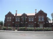
49 Moran St Boulder
Rosewood House
Kalgoorlie-Boulder
Goldfields
Constructed from 1905
| Type | Status | Date | Documents |
|---|---|---|---|
| State Register | Registered | 29 Sep 1998 | HCWebsite.Listing+ListingDocument, HCWebsite.Listing+ListingDocument |
| Type | Status | Date | Documents |
|---|---|---|---|
| (no listings) |
| Type | Status | Date | Grading/Management | |
|---|---|---|---|---|
| Category | ||||
| Register of the National Estate | Permanent | 21 Oct 1980 | ||
| Classified by the National Trust | Classified | 06 Jun 1978 | ||
| Municipal Inventory | Adopted | 09 Jul 2001 | Category 1 | |
St Joseph's Convent is a two-storeyed red brick çresidential building with stucco ornamentation çand corrugated galvanised iron roof, built in ç1905. The Victorian gothic architectural çcharacter is typical of ecclesiastic buildings of çthis period (AHC).
| Name | Type | Year From | Year To |
|---|---|---|---|
| Roman Catholic Church | Architect | - | - |
Individual Building or Group
| Epoch | General | Specific |
|---|---|---|
| Original Use | RELIGIOUS | Monastery or Convent |
| Present Use | RELIGIOUS | Monastery or Convent |
| Style |
|---|
| Federation Gothic |
| Type | General | Specific |
|---|---|---|
| Roof | METAL | Corrugated Iron |
| Wall | BRICK | Common Brick |
| General | Specific |
|---|---|
| SOCIAL & CIVIC ACTIVITIES | Education & science |
| SOCIAL & CIVIC ACTIVITIES | Religion |
This information is provided voluntarily as a public service. The information provided is made available in good faith and is derived from sources believed to be reliable and accurate. However, the information is provided solely on the basis that readers will be responsible for making their own assessment of the matters discussed herein and are advised to verify all relevant representations, statements and information.
Constructed from 1905
Assessment of Significance: St Joseph's Convent is a fine example of Federation Gothic architecture enhanced by its decorative brickwork, fenestration and roof detailing. The addition of a metal fence along the front boundary restricts the visibility of the facade diminishing its streetscape value. (Criterion 1.1) St Joseph's Convent is a landmark in Moran Street as a most imposing and decorative structure which contributes strongly to the visual character of the streetscape. (Criterion 1.4) St Joseph's Convent is a feature of the development of the Catholic school system in Western Australia and in the Goldfields in particular. Its establishment reflected the needs of an increasing Catholic population in the Goldfields during the 1890s and 1900s. (Criteria 2.1 & 2.2) St Joseph's Convent was established by the Sisters of St Joseph of the Sacred Heart, founded by Mary McKillop. The place is closely associated with the teaching work and life of the Western Australian Order, known as the Black Josephites, who broke from the Mother body of the Order in Sydney. (Criterion 2.3) St Joseph's Convent is closely associated with those pupils and teachers who attended the school during its ninety-two year history, including personages such as concert pianist Eileen Joyce. (Criterion 2.3) St Joseph's Convent is highly valued by the Sisters of St Joseph of the Sacred Heart for being a place for their teaching activities in the Boulder area and as a centre for the Order, their life and spirituality. (Criterion 4.1) St Joseph's Convent is highly valued by the number of students and teachers who attended during the ninety-two years it functioned as a school. (Criterion 4.1) St Joseph's Convent is significant for its aesthetic, religious, educational and social associations to the Catholic community and to the wider Kalgoorlie-Boulder community and, as a result, contributes to these communities' sense of place. (Criterion 4.2) St Joseph's Convent is representative of Federation Gothic architecture commonly adopted for ecclesiastic purposes. (Criterion 6.1) St Joseph's Convent is representative of a building built in the early twentieth century to serve religious and educational purposes. (Criterion 6.2) Statement of Significance: St Joseph's Convent, a large Federation Gothic, two-storey brick convent, has cultural heritage significance for the following reasons: - the place is a fine example of Federation Gothic ecclesiastic architecture; - the place contributes strongly to the visual character of Moran Street as an imposing and decorative structure; - the place is closely associated with the teaching work and life of the Black Josephites, the Western Australian Order of the Sisters of St Joseph of the Sacred Heart, which was founded by Mary McKillop; - the place is representative of the development of the Catholic School system in Western Australia, and the Eastern Goldfields in particular, during the late 1800s and early 1900s; and, - the place is valued for its aesthetic, religious, educational and social associations by the Catholic community and the wider Kalgoorlie-Boulder community and, as a result, contributes to these communities' sense of place.
St Joseph's Convent is a two-storey red brick structure on the north side of Moran Street built in the Federation Gothic style (Apperly et al, 1989: 120-123). The building was built to accommodate the Sisters of the Order of the Josephites. Adjacent is All Hallows Church (c.1900), smaller in size and in similar style and materials to the convent. The convent was likely to have been built at the same time as the church as the ornamentation on the church is the same as that on the convent. Federation Gothic style is typical of ecclesiastic buildings of this period, examples include St John of God Hospital Convent (1905), Kalgoorlie, St Mary's Roman Catholic Church (1902) Kalgoorlie, St Andrew's Church (1905) Perth, St Patrick's Basilica and St Patrick's Presbytery (1900, 1916) Fremantle, and St Brigid's Convent (Fmr) (c.1881), Northbridge. Moran Street, Boulder contains St Matthew's Anglican Church (date the church was built is unknown) and St George's Church (c.1890) but are in different styles to St Joseph's Convent and its adjacent church (Hocking Planning and Architecture, 1995). St Joseph's Convent is most imposing and decorative structure of the ecclesiastic buildings in Moran Street. The building is set back from the street alignment with a lawned forecourt. Remnant garden is on the east side of the building, while the rear and west sides are non-landscaped except for some shrubbery in close proximity to the building. The entrance is approached along a narrow path of concrete paving slabs which broadens at the entrance. Concrete paths wrap the periphery of the building. The addition of a metal fence along the front boundary restricts the visibility of the facade diminishing its streetscape value. The building is 'L' - shaped in plan, approximately 27.5 metres long, and approximately 11 metres wide extending to approximately 14.6 metres wide at the north-west corner. The building is orientated east-west with the main entrance facing Moran Street to the south. The facade is symmetrical about a central entrance bay with a small single-storey vestry projecting from the east side. The pitched roof has pronounced brick gables and Dutch gables. The roof is now covered with red painted corrugated iron but it is believed to have originally been covered with slate. Remnants of the slate covering can been seen on the vestry. The roof lacks ornamentation other than tall heavily corbelled rendered brick chimneys, decorative timber bargeboards and louvred vents to the gablets which are visible from the north. The underside of the roof projection is supported on corbelled brick dentils. The exterior walls are faced-brick in English bond. The main feature of the exterior of the building is three projecting bays to the facade. The external corners of these bays and the corners of the building are strengthened by corbelled buttresses. The buttresses are accentuated by rendered copings, now painted. The three bays extend beyond the height of the exterior walls to form stepped gables which are decorated with rendered copings. The eastern bay has a single-storey projection to contain the altar of an oratory. The exterior walls of the projection feature a heavily moulded and rendered battlemented parapet to conceal the roof behind. The vestry on the east side is in matching style to the main building with a gable end and buttressed corners. The main entrance to the building is set in the centre of the central bay flanked by the buttresses and is crowned by a steep gable which is slightly proud of the face of the exterior wall. This gable is finished with a moulded rendered coping and finial at the apex. The doorway is within a brick lancet archway recessed to feature a brick intrados highlighted with tuck-pointing. The arch also features a small voussoirs of a single round brick arch. The fanlight contains timber tracery. The fanlight is believed to have contained leaded and stained glass. A rendered shield is above the fanlight. The fenestration is paired recessed lancet windows between each bay at the ground and first floor level. The lancets contain two light casements and lancet fanlights. The panes are decorated with leaded and stained glass, with the exception of the upper-storey casements which have been replaced with plain glass (other glazing has been replaced with obscure glass). All the windows have painted rendered sills, and are crowned with decorative hood mouldings. The voussoirs of the doorways on the north wall (rear) are tuck-pointed, some are now fully or partly rendered. The reveals of the windows are moulded to match the entrance. The oratory window consists of three conjoined narrow lancet windows supported on fine rendered columns with capitals. The windows are covered with louvres. A wide verandah and timber balcony extend across the rear of the building roofed with a lean-to covered in corrugated iron, and supported on timber posts. A simple timber frieze decorates the underside of the balcony roof. Fibro-cement sheets now provide balustrade infill panels and a skirt below the balcony floor. Evidence remains of the location of the original handrail on the balcony roof posts. The interior comprises a large kitchen and refectory, a laundry, two sitting rooms, a vestry and oratory on the ground floor level, and several bedrooms, two bathrooms and living areas on the upper level. The building interior is impressive in its expansive space, due to its high ceilings, and intricate detailing. Decorative plaster and timber mouldings, and pressed metal ceilings are features, in particular, the intricately painted embossed metal ceiling, cornice and frieze to the entrance hallway and oratory. A hallway forms the entrance to the convent which connects to a wide passage that runs the length of the building at the rear. This passage is approached from the entrance hallway under a corbelled lancet archway decorated with a plaster hood mould and leaded and a stained glass fanlight. At the end of the hall is a carved jarrah staircase which leads to the upper floor bedrooms. A very small office is under the stair landing. On both sides of the entrance hallway is a sitting room featuring fireplaces with timber and marble chimney pieces and iron grates. At the western end of the passage is the refectory and access to the kitchen and to the verandah. The laundry at the north-east corner is an addition and is accessed from the verandah. At the eastern end of the passage is the oratory which gives access to the vestry on the east side (access to the vestry was restricted but is believed to have a jarrah panelled ceiling). A raised altar, framed by a wide arch, is housed within the bay of the oratory. The altar is framed by two niches. On the upper level is a central passage that extends the length of the building. The sisters' bedrooms (11 in total) are small sized and are mainly on the south side of the passage. Bathrooms, living areas and a few bedrooms are on the north side. The passage has three lancet arches each decorated with plaster hood moulds. A laundry has been added behind the sitting room on the north-east corner of the building. The laundry is timber framed externally clad with fibro-cement lining (date the laundry was built is not known). At the west side of the site is a metal clad shed, recently erected. Over the years, sun protective hoods have been fitted above the windows, the bathrooms have been modernised, and an external stair has been added to provide egress from the upper level. Exposed pipes and air-conditioning units are evident on the external walls and lattice screens have been installed to the verandah. Light weight partitions and cupboards have been added to the living areas. Suspended fluorescent lights have been installed throughout and timber floorboards have been covered in carpet. Evidence on the northern exterior wall of the kitchen, including old plumbing fixtures and pipes, suggests that a room, perhaps a laundry, was once attached to the rear of the kitchen. There is evidence of dampness which may be due to ineffective stormwater disposal, and some cracking to walls which may also be due to the above. The roof covering may require attention in parts but as a whole the building appears in a sound condition.
The Catholic Archdiocese of Perth was established in 1846, with Dr John Brady, formerly of NSW, as Bishop (Catholic Church, n.d.: 22). In the same year, the Sisters of Mercy came to Perth and established the first Catholic primary school in Western Australia. This was soon followed by a secondary school for girls (Neal, 1979: 126). Other Catholic primary schools were opened and run by lay teachers. Public funds were provided for both Catholic and government primary schools and only secondary schools charged school fees (the students in these Catholic schools came from various denominations, and included Protestant children). In 1856, Governor Kennedy, a Protestant Irishman, put in place an education system whereby the government would only provide funds for its own primary schools. It could be suggested that this was a deliberate attempt to try and diminish the influence of the Catholic school system, however, tuition fees were still paid and support was given to fund-raising activities, especially for building projects. In 1871, Governor Weld introduced the Elementary Education Act that made school attendance compulsory and also gave denominational schools public funding, 50% of the funds, which were available to public schools. These funds ceased with the introduction of the Assisted Schools Abolition Act 1895. However, during the intervening years, religious groups, such as the Catholic Church, had the financial security to be able to expand their school systems (Neal, 1979: 132-147). Other factors which contributed to this expansion of the independent school system were the general growth of the population and wealth caused by the State’s gold rush, widespread community recognition of the quality of these schools, and the arrival of a number of different religious orders who also took on teaching work (Neal, 1979: 132-147). The Sisters of the St Joseph of the Sacred Heart, founded by Mary McKillop and Father Julian Woods in South Australia in 1866, arrived in Perth in October 1887. The Sisters who came to Perth, Ursula Tynan, Mechtilde McNamara, Irene Ryan and Camilla Ryan, were experienced teachers and had come at the invitation of Bishop Matthew Gibney to set up a school in the mining district of Northampton (Foale, 1995: 21). In August 1888, there were 87 children on the school role (including Protestants), while at the local Government school only 33 were enrolled (Foale, 1995: 21). Led by Sister Ursula, the Western Australian Josephites, split from the mother body in Sydney. Although they continued to be called the Sisters of St Joseph of the Sacred Heart, they adopted back habits instead of the brown usually worn. This led to the Sisters becoming known as the Black Josephites (Foale, 1995: 39). In April 1896, Mother Ursula’s only two postulates, Martha Postans and Magdalen Tuohy, took their perpetual vows. However, by this time, the lead mining in Northampton was in decline and, as a result, many families were leaving the area, taking with them their school age children. Elsewhere, the numbers of Catholic children were rapidly increasing in areas that did not have, as yet, a school. In late 1896, Bishop Gibney asked the Sisters to make the Eastern Goldfields their new sphere of influence. The three Sisters left Northampton in January 1897 and arrived in Boulder in 1897 (Foale, 1995: 34 & 42). In 1896, the twin settlements of Kalgoorlie-Boulder had a population of approximately 20 000, with men outnumbering women two to one. While Kalgoorlie had begun to establish a range of services including hotels, breweries and newspapers, there were only a few permanent buildings in Boulder, South Boulder and Kamballie. Most people still lived in hessian tents or rough wood and iron humpies (Foale, 1995: 35). Many of the prospectors and miners were Catholics and by 1901, approximately one third of all Catholics in Western Australia (about 40 000 in total) were living in the Eastern Goldfields (Foale, 1993: 35). Bishop Gibney appointed Father James Duff to Coolgardie in 1894, and the first recorded Mass was held in a hessian tent in April of that year. Gibney also sent Sisters from the St John of God Order to the Goldfields to care for the sick and dying. They arrived before the Josephites in March 1896. The Sisters established hospitals at Kalgoorlie and Coolgardie and opened the first Catholic school in Kalgoorlie in February 1897, and a second in South Kalgoorlie in October 1897 (Foale, 1995: 46). In September 1896, a community meeting was held to discuss the provision of a school for the 45 children in the Great Boulder area. In October, the community decided to establish a convent school in the area. St Joseph’s school, Kamballie was built near the Great Boulder mine. The arrival of the three Josephites from Northampton coincided with the opening of the building on 7 February 1897 (Foale, 1995: 46 & 47). The Sisters quickly made it known that they would teach all branches of education, including music, and would accept children from all denominations (Foale, 1995: 47). When the numbers of children became too large for these three Sisters to manage, they employed lay teachers to assist them. In 1898 and 1890, the Josephites in Boulder were joined by one English and thirteen Irish postulants (Foale, 1995: 49). By this time, they had a second school at All Hallows in Boulder City. However, the arrival of the new Sisters stretched the resources of the Order and Sisters were forced to beg for money and goods (Foale, 1995: 50). By 1905, the Josephites had five schools in the Goldfields. These were St Joseph’s, Kamballie (moved to South Boulder 1908); All Hallows, Boulder City (destroyed by cyclone 1903); St Brigid’s, Brown Hill (1899); St Joseph’s, Kanowna (1905, which became the Order’s first branch convent); and St Ursula’s, Trafalgar (1905) (Foale, 1995: 53). The Josephites had initially been accommodated in hessian tents until a wood and iron convent was built for them in Wittenoom Street, Boulder. Although this building was severely damaged by the cyclone in December 1903, it became a temporary school for the children as All Hallows had been completely destroyed by the cyclone (Foale, 1995: 47 & 54). Money, which the Sisters had collected for the construction of a new convent, was instead used to fund the erection of a new church-school. This new school, renamed All Hallows, was finished in March 1904 (Foale, 1995: 54). Tenders for the building of the convent were initially given at a cost of £4,200 and higher. The committee of Catholic Church parishioners who were supervising the building's construction chose not to accept any of these tenders. Instead, they appointed the Catholic Church's Clerk of Works, M Carey, to carry out the work. Carey had built St Mary's Roman Catholic Church in Kalgoorlie in 1902 (Kalgoorlie Miner, 20 September 1905). T H Cunningham was the architect of the building and Carey also supervised local tradesmen such as painter Mr Harvey and plasterer J Williams (Kalgoorlie Miner, 20 September 1905). On 20 January 1905, Bishop Gibney laid the foundation stone for the long awaited new convent. Over 5 000 people were present at the ceremony and the collection for the new building amounted to £550, which was quite remarkable considering that twelve months earlier a collection had taken place for a new school. St Joseph’s Convent was completed in September 1905. On 24 September 1905, the Convent was officially opened and blessed by Father Keogh. A number of alterations and changes to the design of the building were made, ballooning out the cost of the convent's construction. In the end, the convent cost £4,000, £200 less the lowest tender that was originally received. After its completion, about half the money spent was still owed by the Catholic Church (Foale, 1995: 54-55). The new convent building was a far cry from the hessian tents that the Sister's lived in when they arrived in Kamballie. The Kalgoorlie Miner announced that the building marked 'a very distinct advance in the architecture of Boulder City’ (Kalgoorlie Miner, 20 September 1905). It went on to state: “the new convent is designed to meet all the developments that the most sanguine Boulderite could reasonably hope for, and judging by appearances it has been built to last as long as Boulder will last” (Kalgoorlie Miner, 20 September 1905). Besides the living and work rooms that accommodated the Sisters, the design of St Joseph's Convent also included a large pupil's dormitory. bathroom and living areas in the upper storey. Although the convent was not officially opened until the 24 September, an opening celebration took place on the 20 September 1905. The celebrations included a torchlight procession by children who attended the Sisters of St Joseph schools at All Hallow's, Kamballie, Trafalgar and Brown Hill Schools, and a school children's bazaar and fancy fair. Other entertainment included the sports, pastimes, songs and dances from Ireland. This included 'a real Irish Turf fire', Irish moss and heather, Irish flanks and yanks of yarn, lace, Irish paintings of Irish scenery and growing shamrocks (Kalgoorlie Miner, 20 September 1905). St Joseph's Convent, Boulder was classified by the National Trust on 6 June 1978 and on 21 October 1980, was also included on the Register of the National Estate. On 18 September 1992, St Joseph's Convent, Crown Reserve 3900, was interim listed on the Western Australia's Register of Heritage Places. In 1994, a memorial was lodged by the Heritage Council of Western Australia on the Crown Land Reserve relating to St Joseph's Convent, Boulder. St Joseph’s Convent functioned as a school-convent from 1905 to 1996, at which time the convent was closed after the last Josephite had left. Although the Sisters of St Joseph are still located in Boulder, at 43 Moran Street. Other Catholic communities include the Sisters of Mercy, the Little Sisters of the Poor and the Christian Brothers. In 1997, parish priest Father Steve Durkin reported that the convent building would be sold after the church had failed to find a practical use for the building (Kalgoorlie Miner, 15 August 1997: 3). The auction was held on 17 September 1997 and the convent was sold for $320 000 to Boulder locals Michael and Judith McKay (Kalgoorlie Miner, 18 September 1997: 3). In the process of readying the land for auction, the Crown Reserve land was cancelled and a Crown Grant was granted on 9 July 1997 to the Roman Catholic Archbishop. On 20 October 1997, the land was transferred to new owners Michael Wayne and Judith Ann McKay. However, the memorial to the land was not noted and the Heritage Council is currently in the process of rectifying the anomaly, by lodging a new memorial (HCWA files, St Joseph’s Convent, Kalgoorlie-Boulder, File No. P0190). In 1997/1998, St Joseph's Convent is currently being renovated by Michael and Judith McKay. A new swimming pool has been installed in the rear grounds of the site and general landscaping has taken place. The metal fence on the front boundary of the building was replaced with a fence of brick pillars and iron infill. The building is in the process of being painted and cracks in the plaster walls are being patched. The owners are also replacing the drainage on the site, fixing the downpipes and gutters. The new owners' long term plans for the site are to establish a bed and breakfast. St Joseph's Convent has been renamed 'Rosewood House' by the McKays.
Integrity: Low Authenticity: High
Good
| Name | Type | Year From | Year To |
|---|---|---|---|
| Roman Catholic Church | Architect | - | - |
| Ref ID No | Ref Name | Ref Source | Ref Date |
|---|---|---|---|
| "Newspaper Article". | Kalgoorlie Miner | 20 September 1905 | |
| Foale, M. T. RSJ ; "The Josephites Go West: The Sisters of St Joseph in Western Australia 1887-1920". p. 34, 35 39, 42, 46-47, 49, 53, 54, 55 | The Josephites Go West: The Sisters of St Joseph in Western Australia 1887-1920 | 1995 | |
| "Newspaper Article". | Kalgoorlie Miner | 18 September 1997 | |
| Apperly, R., Irving, R. and Reynolds, P; "A Pictorial Guide to Identifying Australian Architecture: Styles and Terms from 1788 to the Present". | Angus & Robertson | 1989 | |
| Neal, W. (ed.) ; "Education in Western Australia". | University of Western Australia Press, Perth. | 1979 |
| Owner | Category |
|---|---|
| Roman Catholic Church | Church Property |
This information is provided voluntarily as a public service. The information provided is made available in good faith and is derived from sources believed to be reliable and accurate. However, the information is provided solely on the basis that readers will be responsible for making their own assessment of the matters discussed herein and are advised to verify all relevant representations, statements and information.
Piesse St Boulder
Cnr Lane St
Police Quarters and Lock-Up
Transport Centre, E Goldfields Vol Task force
Kalgoorlie-Boulder
Goldfields
Constructed from 1898
| Type | Status | Date | Documents |
|---|---|---|---|
| (no listings) |
| Type | Status | Date | Documents |
|---|---|---|---|
| (no listings) |
| Type | Status | Date | Grading/Management | |
|---|---|---|---|---|
| Category | ||||
| Classified by the National Trust | Recorded | 06 Jun 1978 | ||
| Register of the National Estate | Indicative Place | |||
| Municipal Inventory | Adopted | 09 Jul 2001 | Category 2 | |
00179 Boulder Police Station, Quarters and Court House (fmr)
Individual Building or Group
| Epoch | General | Specific |
|---|---|---|
| Original Use | GOVERNMENTAL | Police Station or Quarters |
| Present Use | COMMERCIAL | Office or Administration Bldg |
| Type | General | Specific |
|---|---|---|
| Roof | METAL | Corrugated Iron |
| Wall | TIMBER | Other Timber |
| General | Specific |
|---|---|
| SOCIAL & CIVIC ACTIVITIES | Law & order |
| SOCIAL & CIVIC ACTIVITIES | Community services & utilities |
This information is provided voluntarily as a public service. The information provided is made available in good faith and is derived from sources believed to be reliable and accurate. However, the information is provided solely on the basis that readers will be responsible for making their own assessment of the matters discussed herein and are advised to verify all relevant representations, statements and information.
Constructed from 1898
00179 Boulder Police Station, Quarters and Court House (fmr)
The place historic value as it is identifiable with the growth of the mining population in Boulder and is a demonstration of the form of small regional police lock-ups built in the gold boom.
: A single-storey structure with a prominent hipped roof which extends to cover an encircling verandah. Interior linings and finishes have been replaced. Little evidence of its original use is evident.
This place was the site of the Boulder Police Quarters and Lock-Up. Boulder was the first area to demand that a prison be built on the goldfields (Boulder's Hidden Secrets, 1993).
Integrity: Moderate Authenticity: Moderate
Good
| Name | Type | Year From | Year To |
|---|---|---|---|
| PWD | Architect | 1898 | - |
| Ref ID No | Ref Name | Ref Source | Ref Date |
|---|---|---|---|
| "Boulder's Hidden Secrets Golden Footsteps – Join us for a Walk through Boulder as it was at the Turn of the Century". | 1993 |
| Owner | Category |
|---|---|
| WA Police | State Gov't |
This information is provided voluntarily as a public service. The information provided is made available in good faith and is derived from sources believed to be reliable and accurate. However, the information is provided solely on the basis that readers will be responsible for making their own assessment of the matters discussed herein and are advised to verify all relevant representations, statements and information.
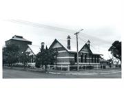
253 Piesse St Boulder
Cnr Brookman St
Boulder Tech School, Boulder High School
Goldfieds SpecEduc Centre(Lorna Mitchell Scl)
Kalgoorlie-Boulder
Goldfields
Constructed from 1905
| Type | Status | Date | Documents |
|---|---|---|---|
| State Register | Registered | 26 Feb 1999 | HCWebsite.Listing+ListingDocument, HCWebsite.Listing+ListingDocument |
| Type | Status | Date | Documents |
|---|---|---|---|
| (no listings) |
| Type | Status | Date | Grading/Management | |
|---|---|---|---|---|
| Category | ||||
| Classified by the National Trust | Recorded | 01 May 1977 | ||
| Register of the National Estate | Indicative Place | |||
| Municipal Inventory | Adopted | 09 Jul 2001 | Category 1 | |
| Name | Type | Year From | Year To |
|---|---|---|---|
| Hillson Beasley | Architect | - | - |
| J Adams, 1st Supt | Architect | - | - |
| John Grainger | Architect | - | - |
Individual Building or Group
| Epoch | General | Specific |
|---|---|---|
| Original Use | EDUCATIONAL | Technical School |
| Present Use | GOVERNMENTAL | Office or Administration Bldg |
| Style |
|---|
| Federation Arts and Crafts |
This information is provided voluntarily as a public service. The information provided is made available in good faith and is derived from sources believed to be reliable and accurate. However, the information is provided solely on the basis that readers will be responsible for making their own assessment of the matters discussed herein and are advised to verify all relevant representations, statements and information.
Constructed from 1905
Assessment of Significance: Kalgoorlie School of the Air is a well proportioned and executed example of Federation Arts and Crafts architecture applied to a school building. It is significant for its expansive hip and gable roof, red face-brickwork enlivened with string courses, fenestration and robust timber detailing which constitute the elevations to Brookman and Piesse Streets. The rear elevation is more modest as it was intended to have additions attached to it. (Criterion 1.1) Kalgoorlie School of the Air is a competent design from Hillson Beasley’s time at the Public Works Department and displays qualities typical of Beasley’s high standards. Planning and elevations are well resolved and the detailed elements are of a high order, particularly the joinery elements of the gables and porches. (Criterion 1.2) Kalgoorlie School of the Air contributes to the aesthetic qualities of the built environment in central Boulder. It is an integral part of a group of places of aesthetic value which contribute to the character of central Boulder. (Criterion 1.4) Kalgoorlie School of the Air is the earliest of the remaining purpose built technical education buildings in Kalgoorlie-Boulder and probably the oldest of this class in the State. Earlier technical schools began their operation in existing buildings. It is significant in relation to the introduction of technical education. (Criterion 2.1) Kalgoorlie School of the Air is significant for its close associations with J. F. Lynch, the second superintendent of the Technical School who went on to become Director of Kalgoorlie School of Mines, then Superintendent of Technical Education and with Mrs Lorna Mitchell, special educationalist. (Criterion 2.3) Kalgoorlie School of the Air was the fourth School of the Air and continues to operate as a school of the air. The building has been adapted in a variety of ways and a study of the place in detail has the potential to yield information on the development of the facilities that are required to provide school of the air services. (Criterion 3.1) Kalgoorlie School of the Air has been highly valued by the community for its educational associations from the time of its role in technical education through its present role as Kalgoorlie School of the Air. (Criterion 4.1) Kalgoorlie School of the Air is closely associated with the core area of the Boulder town centre and as part of the group of places in the centre contributes to the community's sense of place. (Criterion 4.2) Kalgoorlie School of the Air is the only remaining example of a Technical Education building from the Gold Rush period in the Eastern goldfields. It is possibly the oldest extant Technical Education building in the State. (Criterion 5.1) Kalgoorlie School of the Air is characteristic of the Federation Arts and Crafts style of architecture applied to an educational building. Its planning is a conventional program for its time and is representative of a mainstream form. (Criterion 6.1) Kalgoorlie School of the Airis important as a fine, representative example of a small technical school. (Criterion 6.1) Kalgoorlie School of the Air is representative of the work of Hillson Beasley's school designs and of the requirements of Technical Education at the turn of the twentieth century. (Criterion 6.2) Kalgoorlie School of the Air is representative of the development and rapid growth of educational institutions in the Eastern Goldfields from the late 1800's. (Criterion 6.2) Statement of Significance: Kalgoorlie School of the Air, the former Boulder Technical School, a gabled single storeyed, red face-brick school building in the Federation Arts and Craft style has cultural heritage significance for the following reasons: - the place is significant as one of the first purpose built Technical Schools in the State; - the place is an historic building which retains a high degree of authenticity and integrity in good condition; - the place is a competent and representative example of the school design work of prominent Government Architects John Grainger and Hillson Beasley; - the place has aesthetic value as a well-built and finely designed Federation Arts and Crafts building; - the place is associated with F. J. Lynch, the second Superintendent, who later became Superintendent of Technical Education in 1929 serving in that capacity until 1942; - the place is a fine representative example of a small technical school; - the place engenders a sense of place and continuity for the people of Boulder, generations of whom were educated there; - the place is representative of the development and rapid growth of educational institutions in the Eastern Goldfields and is one of a small number of technical educational institutions developed in Boulder; and, - Kalgoorlie School of the Air , the fourth established in Western Australia, forms an important educational and communication link in remote areas around Kalgoorlie. Other elements on the site have little cultural heritage significance. These include the lavatory block, pergolas, perimeter fencing, bitumen paving and soft landscaping elements.
Kalgoorlie School of the Air is gabled iron roof single storeyed, red face-brick school building in the Federation Arts and Craft style (Apperly et al, 1989). Kalgoorlie School of the Air is just out of the Boulder City centre to the north of the Boulder Town Hall, which faces on to Burt Street, the main city street. It is located close to the core of the city centre and is an integral part of the historic core of the centre and in relation to a number of other minor domestic structures which were constructed in the last few years of the nineteenth century. The site, like most of Boulder is flat and is made up of reactive soils. The streets surrounding the site are broad with eight metre roads set in generous road reserves and the streets have well spaced plantings of Queensland box trees (Lephostorum conferta). The buildings comprise the original school building and a toilet block from the Inter-War period and shelters. Kalgoorlie School of the Air is close to the Brookman Street and Piesse Street boundaries. The site has a replacement galvanised tubular steel and chainlink fence to the street boundaries. The original fences were post rail and chainlink to the Brookman Street elevation and a close boarded picket fence to the Piesse Street elevation. The grounds are bitumen paved with areas of lawn to the east of the building and plantings of Cypressus and Erithryna to the edges and in the lawn areas. The lawned area to the east also contains various Eucalyptus species. Immediately around the building is an air drain filled with granite chippings. This in turn is surrounded by bitumen and concrete paving adjacent to all elevations. Kalgoorlie School of the Air is a rectangular plan building. It has an eccentrically located entrance which leads to the administration rooms and via a hallway to a central corridor onto which all the rooms discharge. The exterior of the building is simply expressed in brick, render, joinery and iron in the Federation Arts and Crafts style. The street elevations are organised around steeply pitched gables which are richly decorated with robustly detailed joinery, gable vents and roughcast render. The walls are made of well burnt local bricks with render bands at plinth, sill and window head height. The wall plane is articulated where the gables occur and the windows are tall slender combinations of double hung windows and awning lights. The roof is steeply pitched and is clad with custom orb profile Colorbond steel. The roofscape is enriched by tall brick and render chimneys. The gables are bracketed off the walls with short timber consoles. One of the Brookman Street gables has the entry set beneath it. The entry is accentuated by the inclusion of rectangular pilasters, a broad set of steps and bracketed awning. The joinery work to the awning follows in the same styling as the joinery in the gables. The rear of the building is more utilitarian and the southern end of this elevation was designed to allow a further addition along Piesse Street to be made. This addition was never realised and the straight joints to a potential connecting corridor is the only physical evidence that remains of this intention. The overall composition of the elements of the elevations, the colouring of the bricks and the detailing of the joinery is a robust rendering of the Federation Arts and Crafts style. The entrance hall is modest and passes staff accommodation to the north and a former classroom to the south. The hall links into the central corridor off which all rooms are linked. The central two classrooms have had their corridor walls removed to form a large hall space in the 1962 works, when the toilets were also modified and a kitchen installed in the original library. All classrooms have either corner fireplaces or fireplaces located along the centre of the outer wall, combining elements of Poole and Beasley’s classroom design principles. The exterior of the building remains close to its original form with only the school fencing modifies and some minor alterations to fenestration on the eastern facade where two toilets were introduced into one of the earlier rooms. The interior has been altered to a minor degree in the two southern rooms, but all other rooms have been altered to suit the needs of Kalgoorlie School of the Air. Other historic structures such as the workshops and 1906 blacksmith’s shop which were located on the eastern side of the building were removed in 1962, and most of the original fittings seem to have been removed from this point onwards. A shelter shed on the northern boundary has also been removed. Kalgoorlie School of the Air has been regularly maintained and following minor works in 1997/8 is in reasonable condition, by and large reflecting its original design intent. A number of structural problems caused by the reactive soils have been treated and there are areas of eroded brickwork in the brick plinth which remain of concern. There is a brick and iron toilet block to the east of the school building and this remains in near original condition externally. It is not part of the original concept, but is functionally related to the school and visually unobtrusive. Kalgoorlie School of the Air is in good condition. Maintenance has been regular and effective and recent conservation works have stabilised a number of structural and damp related concerns. Although Kalgoorlie School of the Air no longer serves its intended purpose as a technical education school, it remains in use as an educational facility, though not one to which students frequent. Its role is now a resource base for education to remote areas. This use is compatible with its heritage values. The exterior of the building remains little altered since it was constructed and most of the room plans are in the same form as they were originally conceived. Some adaptation for the purposes of running the place has been made.
Kalgoorlie School of the Air, a brick and stucco building with a corrugated iron roof in the Federation Arts and Crafts Style was built as the Boulder Technical School in 1905, to plans designed by the Public Works Department. It is located on Reserve 8883-253 on the corner of Piesse and Brookman Streets, Boulder. The building sits close to the south west edge of the site and is set in an open lawned and bitumen paved landscape. Technical education classes in Western Australia were started in Perth and Fremantle as evening schools in 1898. These evening classes were organised by local committees assisted by Government Grants and funded by enrolment fees. There were 760 on the rolls in 1898 (Education Department Report, 1899, Vol. 1, No. 15: 42). From 1900, technical evening classes were held at the Boys’ State Schools in Boulder and Kalgoorlie, run by local management boards. In 1904 the administration of the Boulder City evening classes was handed over to the Education Department (Lawson, n.d.). The School of Mines was set up in the Exhibition Building in Coolgardie and transferred to its own campus in Kalgoorlie in 1904, the same year that Boulder Technical School was established in temporary accommodation (Smith, 1995: 26). Boulder Technical School was a branch school of Perth Technical School. By 1911, there were five technical schools in the Goldfields and six others in Perth and regional centres. Boulder Technical School, a purpose-built technical school, was constructed in 1905 at a cost of £3,393. The design was a combination of work by John Grainger and Hillson Beasley. Grainger was frequently ill or away on duties and the final hand in many designs was that of Hillson Beasley. Designs were drawn by draftsmen WW and WBH (Hardwick) (PWDWA 429 Microfiche ‘School of the Air’). The Kalgoorlie Miner described the opening, which took place in June 1906: “Boulder Technical School - this building has been erected at a cost of £3,393 pounds being constructed of brick with cement dressings. The accommodation provided consists of two lecture-rooms, two class-rooms, chemical and physical laboratories, director's library, instructor's room, dark-room, offices and conveniences. In a detached block are workshops for carpentry, plumbing and metalworking. Electric light is installed throughout” (historical notes supplied by CAMS taken from CAMS records. CAMS Premise No. 3092; and Kalgoorlie Miner, 6 August 1947). The first head was Mr J. Adams. His title was Superintendent. The initial enrolment was 60 students but demand was so great that the term closed with 185 (National Trust of Australia (WA) notes supplied by CAMS on disc). Classes in dressmaking, photography and mathematics featured along side carpentry, blacksmithing, and metalwork. Continuation classes were also available. Mr J. Lynch succeeded Mr Adams in 1907. After 1907, rapid expansion of classes took place in trade courses, commerce and women’s arts until the depression years (Lawson, n.d.). In 1911, the staff consisted of Lynch; S. Vine Hall, Instructor in Mechanical Drawing; Frank Glenister, Instructor in Typewriting; T. M. Ede, Instructor in Book Keeping and Accountancy; Sydney Martin, Assistant Instructor in Book Keeping and Accountancy; Sophia Knowles, Instructor in Dresscutting and Millinery; W. H. Frick, Instructor in Ordinary Subjects and Arithmetic and Mensuration; R. D. Lemmon, Instructor in Carpentry; P. W. Swainson, Instructor in Plumbing; and, Frank Mitchell Instructor in Blacksmithing. In 1913, additions were made to the Workshop Block to cater for changes either in the curriculum or enrolment (PWDWA 1637?). Circa 1914, Lynch became Director of the Kalgoorlie School of Mines and was replaced by David Thompson . Thompson only had the title of Officer-in-Charge, so there must have been some sort of scaling back, perhaps due to war time emergency. Thompson retained his position for 15 years, until 1930 (National Trust of Australia (WA) notes supplied by CAMS on disc). The war has a significant impact on the number of staff and students and the amount of money available for maintenance. The Apprentices Act of 1918 attempted to preserve places for servicemen to return, while continuing normal operations of the school. The 1920 report of the Royal Commission into education in Western Australia, presented by Peter Board of NSW, criticised the technical education provided in the State, indicating that too much commercial and office type courses were being delivered. Premier Mitchell also reintroduced fees for non vocational students. The 'general education' courses were severely reduced as a consequence. Finance was also cut for maintenance. Education was narrowed to a more technical bias. In 1925, the Collier Government introduced day-release training for workers. This occurred in the employers' time and at their expense, but difficulties with implementing this policy this meant by 1929, only 64% of trades were complying. Neither employers or unions were happy with the concept and technical education fell into disrepute. Meanwhile in Boulder, under the direction of Thompson, Sheet Metalworking, Commercial Law and Auditing, English, Mechanical Drawing and Shorthand were added to the subjects available in 1926. However, Carpentry, Blacksmithing, Plumbing and Ordinary Subjects were no longer taught. Allen retired from Head of Technical Education in 1928. Lynch was transferred to Perth and became Superintendent of Technical Education in 1929. Back at Boulder, Leon Zeffert, the Commercial Master who followed Thompson in 1930 was appointed 'Principal'. His task was made difficult with the onset of the Great Depression and consequent Western Australian Government cutbacks. Continuing education classes at Perth Technical School were discontinued and preparatory technical classes were substituted. It is probable that similar changes were made in Boulder. The drop in enrolments during the Depression almost caused the closure of Boulder Technical School (Lawson, n.d.). There was a temporary freeze on staffing, building and purchase of equipment. Mr Whitton B.A. replaced Zeffert as the Principal of Boulder Technical School and drawings for proposed new workshops were made c. 1933 (PWDWA 1071, 1933). Slow post-Depression recovery influenced the education policy of successive Labour Governments between 1933 and 1947. A goldmining boom, led by Claude de Bernales, lessened the adverse economic effects in Western Australia somewhat. Improvements in enrolments at the Boulder Technical School began to take place from 1935, and the school became known as the Eastern Goldfields Technical School (Lawson, n.d.). In 1940, Stacey Turner A.I.F.A. became principal and during his term in office, the school's activities were expanded by the addition of self supporting classes in dresscutting and pre-apprenticeship classes (National Trust of Australia (WA) notes supplied by CAMS on disc). Additions were made to the carpenter's shop (PWDWA 29417). The years of World War II saw a modest expansion of the school, as military personnel took advantage of the availability of technical education (Lawson, n.d.). Lynch retired as Superintendent of Technical Education in 1942, and was succeeded by Leslie W. Phillips (Phillips [from Victoria] had studied at the University of London at the time of the introduction of the National Certificate and Diploma courses). Phillips prepared a report on the State's technical training needs that was implemented. He favoured the introduction of Associateship & Diploma courses. Legislation was passed by the Western Australian Parliament in 1943, which extended compulsory education to 15 years of age. The Commonwealth Reconstruction and Training Scheme was also instituted throughout Australia about this time. The WA committee, chaired by Phillips, reported in 1944. These events all had a bearing on what was taught at Boulder and the equipment and facilities required. Following World War II, Mr R. N. Lawson B.A. became principal. The school's activities expanded to include a full time dressmaking course and day classes for engineering apprentices. It played an important part in the Commonwealth Reconstruction Training Scheme with a total enrolment of 800 students (National Trust of Australia (WA) notes supplied by CAMS on disc). The Kalgoorlie Hippodrome had to be used as an annexe to cope with the increase in enrolments. Day classes in carpentry, plumbing, sheet-metal work and boilermaking were introduced in 1945; engineering was introduced the following year (Lawson, n.d.). PWD Drawing 1071/39 shows the block plan of Kalgoorlie School of the Air at this time. In 1947, W. (George) Hayman was Acting Superintendent of Technical Education. His report 'Development of Technical Education in Western Australia' changed the direction of this branch of the Education Department. The emphasis on supplementing 'trade' training for apprentices was replaced with the ambition to provide full-time technical and academic courses for vocations. These were classed as Associateship, Diploma and Certificate courses of four, three or less years, as well as some secondary education. A diagram of the structure in force is shown in the Technical Education Handbook of 1948. In 1947, a new technical school was established midway between Kalgoorlie and Boulder and many of the trade courses were transferred to the new site (Lawson, n.d.). This transfer left commercial and domestic arts, together with general technical courses at the Boulder site. Part-time courses were provided for those already in employment. They included Diploma, Certificate, Trade and special courses (the specific courses available at Boulder has not been investigated). Hayman became Superintendent of Technical Education in 1949, and remained in that position until 1962. Hayman oversaw the implementation of the reforms he had signalled in his earlier report. As part of this implementation, the Boulder Technical School became Boulder High School. Whether this was a new name for the courses that were being taken or a new use for a now obsolete building following an amalgamation is uncertain. From 1952, the building housed the Boulder High School, a three year technical type school offering a Commercial Junior Course, with a Home Science course for first and second year classes. An 'opportunity class' was also established (CAMS file notes). The block Plan of the School in 1955, is held in the CAMS collection. However, the building was no longer suitable for the requirements placed on it and when the new wing at Eastern Goldfields High School was completed in 1962, the two schools amalgamated, with activities centred at the Eastern Goldfields High School. Drawings were made to convert Boulder Technical School for use as a 'Slow Learners Occupation Centre', primarily for those affected by the Rubella epidemics of a few years earlier. These were undertaken in 1962/3. Further repairs and renovation took place in 1969/70, by which time the building was known as the 'Special Education Centre' (PWDWA Att. to 150305). Whether this is merely a strategic change of name or a change of focus has not been established. By 1977, when it was Recorded by the National Trust of Western Australia, the Special Education Centre was under the direction of Mrs Lorna Mitchell, a former Coolgardie Primary pupil and Eastern Goldfields High School student. It was sometimes referred to as the 'Lorna Mitchell Centre'. In 1991, the building became 'Kalgoorlie School of the Air '. The first school of the air in Western Australia was established in 1957, to cater for correspondence pupils in remote areas. The fourth School of the Air commenced in Kalgoorlie in 1962. This was the precursor to the current school, located in the former Boulder Technical School, which became Kalgoorlie School of the Air . In 1997, minor works were undertaken to provide production standard studios in former classrooms and in 1998 minor works were undertaken to stabilise the structure and replace damaged brickwork.
Integrity: High Authenticity: High
Good
| Name | Type | Year From | Year To |
|---|---|---|---|
| John Grainger (PWD) | Architect | 1905 | - |
| J Adams, 1st Supt | Architect | - | - |
| Hillson Beasley, (PWD) | Architect | 1905 | - |
| Ref ID No | Ref Name | Ref Source | Ref Date |
|---|---|---|---|
| Lawson, R; Eastern Goldfields Technical School in Jubilee Brochure". | Technical Education Branch, Education Department of Western Australia. | Undated | |
| 071/39 | Drawing | PWD |
| Owner | Category |
|---|---|
| Education Department | State Gov't |
This information is provided voluntarily as a public service. The information provided is made available in good faith and is derived from sources believed to be reliable and accurate. However, the information is provided solely on the basis that readers will be responsible for making their own assessment of the matters discussed herein and are advised to verify all relevant representations, statements and information.
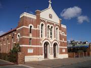
36-38 Piesse St Boulder
Residences (Units) 36-38 Piesse Street
Kalgoorlie-Boulder
Goldfields
Constructed from 1904
| Type | Status | Date | Documents |
|---|---|---|---|
| State Register | Registered | 30 Jun 1995 | HCWebsite.Listing+ListingDocument, HCWebsite.Listing+ListingDocument |
| Type | Status | Date | Documents |
|---|---|---|---|
| (no listings) |
| Type | Status | Date | Grading/Management | |
|---|---|---|---|---|
| Category | ||||
| Municipal Inventory | Adopted | 09 Jul 2001 | Category 1 | |
| Classified by the National Trust | Recorded | 02 Aug 1971 | ||
| Register of the National Estate | Indicative Place | |||
| Name | Type | Year From | Year To |
|---|---|---|---|
| James Hine (Hine & Selby) | Architect | - | - |
Individual Building or Group
| Epoch | General | Specific |
|---|---|---|
| Present Use | RELIGIOUS | Church, Cathedral or Chapel |
| Original Use | RELIGIOUS | Church, Cathedral or Chapel |
| Style |
|---|
| Federation Free Classical |
| Type | General | Specific |
|---|---|---|
| Wall | BRICK | Common Brick |
| Roof | METAL | Corrugated Iron |
| General | Specific |
|---|---|
| SOCIAL & CIVIC ACTIVITIES | Religion |
This information is provided voluntarily as a public service. The information provided is made available in good faith and is derived from sources believed to be reliable and accurate. However, the information is provided solely on the basis that readers will be responsible for making their own assessment of the matters discussed herein and are advised to verify all relevant representations, statements and information.
Constructed from 1903
Assessment of Significance: Queen's Methodist Church demonstrates a bold simplicity and a restrained use of religious symbols and decorative motifs combined with a flat two dimensional quality, unusual in church design at the turn-of-the-century; Despite its present condition, Queen's Methodist Church is an important building in the local streetscape, and is regarded by the community as a Boulder landmark. (Criterion 1.3) The construction and size of Queen's Methodist Church is closely associated with the rapid population growth in the eastern goldfields, at the turn of the century. The name of the church reflects the respect felt by the community for the British monarchy in Australia at the time. The site has some historic value as a place of continuous religious worship since 1897 to the mid 1970s. (Criterion 2.2) Queen's Methodist Church is the only known work by Hine in the goldfields, and is a significant example of the several churches he designed in Western Australia, between 1895 and 1915. (Criterion 2.3) Queen's Methodist Church has some social significance as an important focus for religious and social life in Boulder. For many years the church was renowned as a centre of musical culture in the eastern goldfields. (Criterion 4.1) The church is held in high regard by the community; being listed in the town planning scheme as a place of heritage value, and being the subject of a petition of some four hundred signatures in 1993. (Criterion 4.1) Constructed of Coolgardie brick, Queen's Methodist Church was the first brick church in Boulder, and is the only known work undertaken by Hine and Selby in the eastern goldfields. (Criterion 5.1) Statement of Significance: Queen's Methodist Church has cultural significance for the following reasons: - Queen's Methodist Church is of unusual design, exhibiting a bold simplicity, weighty assertiveness, and restrained use of religious motifs atypical of gothic revival churches of the 1900s. The modelling of the load bearing brickwork, vertical expression of the semicircular arched openings, and gabled parapet facade are important elements of this bold design; - built in the midst of the gold boom, the place is large for a Methodist church and is closely identified with the growth of the mining population in Boulder. The naming of the church in honour of Queen Victoria reflects the strong ties of the community to the British monarchy; - for many years Queen's Methodist Church was an important focus for religious, social and musical culture in the eastern goldfields; and, - Queen's Methodist Church is held in high regard by the local community for its landmark quality and historical associations.
Queen's Methodist Church is located on Piesse Street, Boulder. 'It rests on 2 000 square metres of land and has no graveyard' (petition addressed to City of Kalgoorlie-Boulder, 9 August 1993). The church is a prominent building in an otherwise low scale streetscape: the two storey gabled facade, with projecting religious motif, provides a distinctive skyline feature. Kalgoorlie Miner reported the church as having a 'satisfying harmonious front, rising high up to a cross, strongly buttressed walls with high windows heavily leaded in a chaste and attractive design...' (Kalgoorlie Miner, 16 November 1993: 3). The building is rectangular in plan, '96 (ft) x 46 (ft) in the clear' and symmetrical along its long axis (Kalgoorlie Miner, 30 September 1903: 4). It has load bearing brick walls, a rendered dado plinth, and a corrugated iron covered roof, concealed from the street by a gabled parapet. The front and side walls are articulated into rectangular vertical bays, while the front wall is divided by horizontal stucco bands, which express window and door openings. The church is characterised by its eclectic combination of romanesque and gothic elements. While the stepped buttresses and gabled portico's over the two front doors reflect some gothic attributes, the over all design symmetry, structural expression of the load bearing walls, and gabled parapet with semicircular arched motif, reflect a more romanesque flavour. In 1961, the church interior was severely altered. The sloping floor of the church was levelled, being raised in the back half and lowered at the front, with steps installed between the two levels. A full height stud wall was constructed to divide the community space at the rear of the church from the religious activities at the front. In the community area half height stud partitioning divided the north eastern area into five small rooms. The sill height of windows along this wall was lowered to allow more light into these new rooms. A new exit door was built into the western wall. The original planning of the interior can still be identified; however ,the alterations have greatly diminished the original character of the interior space. At the time of sale in 1986, the West Australian reported the high curved jarrah ceilings as a feature of the church, even though the full height partition disrupts the space. The article also noted that the church altar and pews were removed after the church was closed (West Australian, 1 September 1986: 70). The interior has been greatly altered with the adaptive re-use of the place as apartments.
The first church at 38 Piesse Street, Boulder, was a corrugated iron structure, built in 1897, and named the Queen's Methodist Church. The name of the church was chosen to celebrate the 60th anniversary of the reign of Queen Victoria (National Trust of Australia (WA), Queen's Methodist Church Boulder, assessment exposition, August 1982). However, within a few years it was recognised that a more substantial church building was required to accommodate the rapidly growing Methodist population in Boulder. In September 1903, the Methodist Church (WA) accepted the tender of £2,939 from Ellis, Pitman and Tottendell for a brick church to seat 750 people (National Trust of Australia (WA), Queen's Methodist Church Boulder, assessment exposition, August 1982). The Kalgoorlie Miner noted that in the new church 'space has been allowed for seating accommodation for 750 people', and the Western Argus described the church as having '..the largest ground floor area of any Methodist Church in the State' (Kalgoorlie Miner, 30 September 1903: 4; Western Argus, 8 March 1904: 15). A public ceremony to unveil the memorial tablets (in lieu of the usual foundation stone laying), took place on 28 October 1903 (Kalgoorlie Miner, 30 September 1903: 4). The tablets can be seen high up on the frontage of the church, facing Piesse Street. Mr I. W. Goss and Cr Fred Mitchell, two of the oldest members of the Boulder Church, were entrusted with the duty of unveiling the tablets. The Mayor of Kalgoorlie (Mr N. Keenan) and the Mayor of Boulder (Mr W. T. Rabbish) were among the guests and speakers at the unveiling (Kalgoorlie Miner, 29 October 1903: 4). The official opening of the Queen's Methodist Church took place on 6 March 1904. As described in the Western Argus: "the opening commenced with a morning service and was followed by celebrations and services throughout the day. "Special features of the service were the splendid choral music and orchestral accompaniments. There were about 100 well trained singers on the platform... " (Western Argus, 8 March 1904: 15). Queen's Methodist Church was designed by James Hine, a partner in the Perth architectural firm Hine and Selby. Hine and Selby designed a range of domestic and commercial buildings in Perth, as well as several non-conformist churches, including Congregational Church, Subiaco (1905), additions to Methodist Church, Maylands (1905), and St Andrews (Presbyterian) Church (1906), St George's Terrace, Perth (Considine and Griffiths, 1995). However, Queen's Methodist Church is their only known work in the goldfields. Built of Coolgardie bricks, Queen's Methodist Church was the first brick church in Boulder (National Trust of Australia (WA), Queen's Methodist Church Boulder, assessment exposition, August 1982). The appearance of Queen's Methodist Church is unusual by comparison to the more traditional form of parish churches at the time. While most churches were built in a Gothic Revival style, characterised by vigorous three-dimensional modelling of forms and details, the massing and form, and in particular the facade of Queen's Methodist Church is strikingly different in its two dimensional bold simplicity. The overall image was more like a local hall than a church. This design was not typical of the church designs of Hine and Selby, although some of this bold simplicity is also evident in the unusual proportions of St Andrew's Church, Perth. For many years Queen's Methodist Church was noted as the centre of music culture in the Eastern Goldfields. An article in the Kalgoorlie Miner recording the celebrations of the diamond jubilee of Queen's Methodist Church in 1963, described the church as, 'a centre of great activity, ...known for its hymn - singing congregations' (Kalgoorlie Miner, 16 November 1963: 3). The article noted 'the significant contribution this church has made to the life of the goldfields' and commented on its renowned musical past. The diamond jubilee festivities were reported to be 'a worthy tribute to Queen's renowned musical past' (Kalgoorlie Miner, 16 November 1963: 11). In 1961, the interior layout of the Queen's Methodist Church was severely altered. Rather than use one large open space, the congregation requires separate spaces to accommodate church services, a hall, small class rooms and a kitchen. These interior alterations were designed by Perth architect K. Broadhurst and a quote of £4,500 from builder T. D. Scott was accepted. When the alterations were completed, the old 'tin church' which had been used as a hall and Sunday School was dismantled (National Trust of Australia (WA), Queen's Methodist Church Boulder, assessment exposition, August 1982). Queen's Methodist Church was closed in December 1975, as a part of the rationalisation of church properties following the amalgamation of the non-Conformist Churches to form the Uniting Church. In December 1978, the property was bought by a local politician, Mr Graeme Campbell (Labour MHR for Kalgoorlie), to save the church from demolition. Eight years later (1986), the building was advertised for sale at the price of $30 000, and eventually sold to Ms N Hall (West Australian, 1 September 1986: 70). Due to a number of factors, little work was done on the place to maintain it. In 1991, an article in the Kalgoorlie Miner stated '…the building's oregon pine ceiling was being destroyed by rain and pigeon droppings and its interior walls were covered in graffiti' (Kalgoorlie Miner, 24 July 1991: 2. The reference to the oregon pine ceiling is incorrect; the ceiling is lined with jarrah boarding). In 1993, a petition of some 400 signatures was presented to City of Kalgoorlie-Boulder, and a copy forwarded to the Minister for Heritage, requesting that the place be repaired and upgraded 'for the protection of the residents and the beautification of our city ...' (petition addressed to City of Kalgoorlie-Boulder, 9 August 1993). In 1994, Queen's Methodist Church was sold to M. D. Glendinning and Tanvier Pty Ltd for $80,000, who proposed to convert the place for residential use. The scheme involved the restoration of the church, the restoration of its fabric and conversion to eight residential units within the church, with an additional six units at the rear. This work has been completed. The Insurance Plans for Boulder c. 1900 illustrate the brick Queen's Methodist Church with Lot 35 occupying a Hall made of iron, and Lot 36 having a shed, a dwelling, and several outbuildings, all made of iron. Also on Lot 36 facing Piesse Street were two iron sheds one being for Mann Bootmaker and the other for Goss Undertaker, both with verandahs over the footpath.
Integrity: Low Authenticity: Low
Good
| Name | Type | Year From | Year To |
|---|---|---|---|
| James Hine (Hine & Selby) | Architect | 1903 | - |
| Ref ID No | Ref Name | Ref Source | Ref Date |
|---|---|---|---|
| "Newspaper Article". p.4 | Kalgoorlie Miner | 30 September 1903 | |
| "Newspaper Article". p.4 | Kalgoorlie Miner | 29 October 1903 | |
| "Newspaper Article". p1 | Kalgoorlie Miner | 16 November | |
| "Newspaper Article". p.15 | Western Argus | 8 March 1904 | |
| Considine and Griffiths Architects Pty Ltd ; "Former Charles Street Mission Methodist Chapel and Methodist Church Conservation Plan.". | Considine and Griffiths Architects Pty Ltd | 1995 |
| Owner | Category |
|---|---|
| Various | UNKNOWN |
This information is provided voluntarily as a public service. The information provided is made available in good faith and is derived from sources believed to be reliable and accurate. However, the information is provided solely on the basis that readers will be responsible for making their own assessment of the matters discussed herein and are advised to verify all relevant representations, statements and information.
Railway St Broad Arrow
On orig railway reserve, directly in front of Broad Arrow Tavern
Kalgoorlie-Boulder
Goldfields
Constructed from 1897 to 1995
| Type | Status | Date | Documents |
|---|---|---|---|
| State Register | Registered | 20 Sep 2002 | HCWebsite.Listing+ListingDocument, HCWebsite.Listing+ListingDocument |
| Type | Status | Date | Documents |
|---|---|---|---|
| (no listings) |
| Type | Status | Date | Grading/Management | |
|---|---|---|---|---|
| Category | ||||
| Municipal Inventory | Adopted | 09 Jul 2001 | Category 1 | |
Other Built Type
| Epoch | General | Specific |
|---|---|---|
| Original Use | Transport\Communications | Rail: Water Tower |
| Present Use | OTHER | Other |
| Type | General | Specific |
|---|---|---|
| Other | CONCRETE | Concrete Slab |
| Other | TIMBER | Log |
| Wall | METAL | Cast Iron |
| General | Specific |
|---|---|
| TRANSPORT & COMMUNICATIONS | Rail & light rail transport |
This information is provided voluntarily as a public service. The information provided is made available in good faith and is derived from sources believed to be reliable and accurate. However, the information is provided solely on the basis that readers will be responsible for making their own assessment of the matters discussed herein and are advised to verify all relevant representations, statements and information.
Constructed from 1897, Constructed from 1995
Assessment of Significance: Railway Water Tower, Broad Arrow is highly valued by the Goldfields community as an identifiable built representation of the railway presence that was previously in the town. (Criterion 1.1) Railway Water Tower, Broad Arrow has a landmark setting in the Broad Arrow town. It is dominant in the vista west from the Kalgoorlie-Menzies Road. It is integral within, and contributes to, the townscape and character of Broad Arrow. (Criterion 1.2) Railway Water Tower, Broad Arrow, together with the adjacent Broad Arrow Tavern and two dwellings, forms a unique cultural environment that is the township of Broad Arrow. (Criterion 1.4) Railway Water Tower, Broad Arrow was part of the extensive Eastern Goldfields railway system that enabled the successful exploitation of the gold deposits in the region. The place illustrates the importance of the railway system in this process and in the development of the supporting townships. (Criterion 2.1) Railway Water Tower, Broad Arrow is an example of a water supply system fashioned to fit prevailing conditions and environment. The place illustrates the difficulties of providing steam-powered rail transport over long distances in Western Australia. (Criterion 2.2) Railway Water Tower, Broad Arrow is one of three remaining elements that represents the original railway presence in Broad Arrow and dates to the inception of the railway through Broad Arrow in 1897-8. (Criterion 2.2) Railway Water Tower, Broad Arrow has been associated with the Water Corporation in providing a reticulated water supply to the residents of Broad Arrow since c. 1990, and as such is one of a small number of railway water tanks still in use in the State. (Criterion 2.3) Railway Water Tower, Broad Arrow contributes significantly to the local community and wider district’s sense of place for its aesthetic appeal, and as a reminder of Broad Arrow's early railway and goldmining history. The desire to retain the tank as part of the local water supply scheme, despite its deteriorating condition, is indicative of this. (Criterion 4.2) Statement of Significance: Railway Water Tower, Broad Arrow, a 25,000 gallon (113 kL) square cast iron water tank, constructed in sections, on a thirteen foot (4 metre) timber pole stand, has cultural heritage significance for the following reasons: - the place was part of the extensive Eastern Goldfields railway system, which enabled the successful exploitation of the gold deposits in the region, and illustrates the importance of the railway system in this process and in the development of the supporting townships; - the desire to retain the tank as part of the local water supply scheme indicates that the place is highly valued by the Goldfields community as the last remaining identifiable built representation of the railway presence dating from 1897; - the place is an example of a water supply system fashioned to fit prevailing conditions and environment. The place illustrates the difficulties of providing steam-powered rail transport over long distances in Western Australia. Since c. 1990, its use by the Water Corporation to provide a water supply to the township of Broad Arrow is an innovative extension of its original purpose; - the place has a landmark setting in the Broad Arrow town. It is dominant in the vista west from the Kalgoorlie-Menzies Road. Together with the adjacent Broad Arrow Tavern and two dwellings, the place forms a unique cultural environment that is the township of Broad Arrow; and, - the place is one of a small number of railway tank stands still in use in the State, although this water no longer serves railway purposes. The tank itself can no longer be used to store water. A fibreglass water tank is situated within the original cast iron tank.
Railway Water Tower, Broad Arrow is located within the original railway reserve on the west side of the main street in Broad Arrow, directly in front of the Broad Arrow Tavern. There is no physical association with the existing railway line, which is located some distance east of the tavern. Railway Water Tower, Broad Arrow is a significant element within the Broad Arrow town, being the tallest of the four structures that make up the settlement. The place is centrally located within a flat gravelled area, approximately 100 metres west of the tavern. Railway Water Tower, Broad Arrow was built to a standard WAGR design. The square cast iron tank is typical of the tanks usually constructed on the main lines. The tank is supported by a square grid of three bush timber posts along each edge, comprising three rows of three posts. The posts may be original. Some are weathered, although this appears to be superficial. The posts are supported by bed logs of sawn timber on concrete foundations. The bed logs comprise milled timbers with steel plate connections bolted to the posts. The concrete foundations have chamfered edges, and appear to be original fabric. Each of the bed logs and foundations extend the length of three posts aligned north south. Milled timber cross bracing on the stand is not original fabric. The tank platform comprises a series of pairs of milled timber bearers aligned north south, corresponding with the bed logs below, supporting sets of double joists, on which the tank is located. Timber angle brackets between the bearers and joists and the posts, have been inserted around the perimeter of the tank platform. The square tank comprises a number of cast iron panels welded together. The corners of the tank are rounded. There are cracks in the tank, with a serious vertical crack evident on the northwest corner. The steel and iron water pipe and fittings are still in place beneath the tank. The steel ladder remains in place, although a flat iron covering on the lower sections prevents access. A steel platform and railing is in place at the top of the ladder. The separate internal water tank was not visible from ground level inspection.
Railway Water Tower, Broad Arrow is a 25,000 gallon (113 kl) square cast iron water tank on a thirteen foot (4 metre) timber pole stand. The place is situated on Broad Arrow Lot 587, gazetted Reserve 4836 as a railway reserve (DOLA, Reserves Index Enquiry). Railway Water Tower, Broad Arrow was constructed in 1897 or 1898, by railway contractors Smith and Timms to provide water for the steam engines on the Kalgoorlie-Menzies line. Circa 1990, it was taken over by the Water Corporation to provide a water supply for the town. A fibreglass tank was fitted inside the cast iron tank c. 1995. The discovery of gold at Southern Cross and the subsequent declaration of the area as the Yilgarn goldfield in 1888, prompted the State Government to commence construction of a railway to service the area. The line, initially known as the Yilgarn and later the Eastern Goldfields railway, began at Northam (The name ‘Yilgarn Railway’ was replaced with ‘Eastern Goldfields Railway’ in 1899-1900 [WAGR Annual Report, 1900: 2). The line reached Southern Cross on 1 July 1894, and was opened to Kalgoorlie in September 1896. Gold was discovered north of Kalgoorlie at Broad Arrow in 1893, and the Broad Arrow goldfield was gazetted on 11 November 1896. A line from Kalgoorlie to Menzies was begun in August 1897, and reached Broad Arrow on 6 November that year. The line to Menzies was opened on 23 March 1898, and was handed over to the government on 13 February 1899. The railway provided efficient transport of mining machinery, timber, food and other goods that had previously relied on camels and horses (Gunzberg and Austin, 1997: 207 & 229). Smith and Timms were the contractors for the Kalgoorlie-Menzies section of the Eastern Goldfields line. Henry Teesdale Smith and Joseph Timms, both from Victoria, had built railway lines in Tasmania and New South Wales before arriving in Western Australia in the early 1890s. Their first contract in the State was for the Boyanup-Busselton line in 1893, followed by the Kalgoorlie-Menzies and Kalgoorlie-Kanowna lines, and the York-Greenhills line. Smith was General Manager of Millars Timber Co until 1907, having started with the company in Victoria as a railway contractor in 1874, and was MLA for Wellington from 1901-1904. Despite his other interests, he and Timms continued to build railways, including the Port-Hedland-Marble Bar line (1909-1911), and other lines in South Australia and New South Wales (Gunzberg and Austin, 1997: 229-230). The town of Broad Arrow developed rapidly, as was usual with goldmining settlements. The first shelters of canvas and hessian were soon replaced with timber and iron buildings as the importance of the gold finds was confirmed. The railway buildings were constructed of stone and brick. Broad Arrow was gazetted a municipality in 1897. The town had a Resident Magistrate, mining registrar, hospital, three churches, Salvation Army Hall, chemist, two banks, a stock exchange, police station, post office, two breweries, a cordial factory, eight hotels, six grocery stores and two drapery, blacksmith and bakers' shops. Broad Arrow provided administrative and public facilities for the population employed in the mines, including the smaller mining areas of Smithfield, Black Flat, White Flag, Grant's Patch and Ora Banda (Ware, n.d.: 1976). One of the major issues for the goldmining districts, and the railways which supported them, was the supply of water. Large amounts of good quality water were required for mining operations, the operation of railway steam engines, and for the use of the population. Water storage dams, called 'tanks', were constructed by the Mines Department and by railway contractors. The dams were fed from large catchment areas, often utilising the natural landforms of the area. Tenders were called by the Public Works Department Water Supply Division for the construction of one such dam at Broad Arrow in 1897 (Western Australian Government Gazette, 9 April 1897: 622). This provided water for the growing township, the mining operations and the operation of the railway (Western Australian Government Railways and Tramways Annual Report, 1905/06: 74). The Broad Arrow dam held over 10,000,000 gallons (2,200 kl). Water was pumped from the dam by a steam pump (Western Australian Government Railways and Tramways Annual Report, 1900: 57). Railway Water Tower, Broad Arrow was most likely constructed by the railway contractors, Smith and Timms, during construction of the Kalgoorlie-Menzies line. The place was built to a standard WAGR plan, and water was supplied from the Broad Arrow dam. Railway Water Tower, Broad Arrow was part of the wider system of over 100 dams and tanks managed by WAGR along its many kilometres of railway line (WAGR Annual Report 1905/06: 74; WAGR standard drawings, CCF 27893, 13 ft tank stand for a 25,000 gallon engine water tank and EEL 2873, engine water tank 25,000 gallons. Note: no separate tenders for the construction were located). Railway Water Tower, Broad Arrow was situated at the southeastern end of the Broad Arrow railway yard. The railway reserve comprised a station building about 80 feet (24.4 metres) in length with a 350 foot (106.6 metre) passenger platform, goods shed, station master's house, and at least three two-room platelayer's cottages. The station building and the railway employee's residences were all constructed of stone (WAGR plan, Kalgoorlie-Menzies railway, EEL NO. 5199, undated). Broad Arrow was a major stop on the Kalgoorlie-Menzies line, with a refreshment room provided at the station, especially important when the line was extended to Leonora in 1903. A site plan, dated 1901, indicates a proposal to relocate Railway Water Tower, Broad Arrow to a more central position in the railway yard. The relocation did not take place, according to the current position of the structure in relation to the streets and the town (WAGR plan, Broad Arrow, EEL 5248, 22 November 1901; photograph, 1989, in Barber, 1998: 39). The boom period for gold production was between 1893 and 1906. As early as 1903, population numbers were declining. That year, the Broad Arrow and Paddington councils amalgamated. By 1909, gold production had dropped considerably and the population had declined further. In 1910, the amalgamated councils became the Broad Arrow Road Board District. The State batteries that serviced the smaller mines in the district had closed by 1917. In 1925, Broad Arrow Road Board was absorbed by Kalgoorlie Road Board, and services at the railway station were downgraded with the removal of the resident station master (Ware, 1976; Webb, 1993: 606-607). Railway Water Tower, Broad Arrow supplied water to the steam engines on the Kalgoorlie-Leonora line until the introduction of diesel engines in the 1950s. The diesel engines were first put into service on the Eastern Goldfields and Northern railways which ran through the dryer areas of the State (Higham, 1971: 15). In the 1960s, the issue of rail gauge standardisation was finally addressed. At Parkeston, 4 kms east of Kalgoorlie, the narrow Western Australian gauge line met the standard gauge line from the east. Freight was transferred here from one line to the other, and through passengers transferred at Kalgoorlie station. Construction of the standard gauge line from Perth to Parkeston began in 1962, and the first standard gauge train ran to Fremantle in November 1966 (WAGR, 1975: 7-8). Freight services continued on the Kalgoorlie-Leonora narrow gauge line to service the ongoing mining operations, but the station buildings were removed. In the early 1990s, a standard gauge line was built from Kalgoorlie to Leonora. This line passed to the east of the narrow gauge line. The narrow gauge line tracks were removed from the old railway reserve. Although Broad Arrow and surrounding districts have been subject to continued mining, with the mineral boom in the 1950s and 1960s and more recent open pit mining, the workers for these operations commute from Kalgoorlie and Boulder. Very little remains of the original town of Broad Arrow (Ware, 1976; Webb, 1993: 606-607; Barber, 1998). The water supply dams, which usually provided good quality water, were taken over for use by the Country Water Supply in a number of districts. Circa 1990, the Water Corporation provided Broad Arrow residents with a reticulated water supply, utilising Railway Water Tower, Broad Arrow. Water supplied from the dam to the tank was fed by gravity to the individual services. Following later problems with the turbidity of the dam water it was decided to transport water by road from Kalgoorlie, two to three times a week as needed. The deteriorating condition of the cast iron tank, however, required that another tank be provided. While the initial proposal was to remove the cast iron tank and install a new fibreglass tank on the tower, the local community requested that Railway Water Tower, Broad Arrow be retained for aesthetic reasons. This resulted in the fibreglass tank being fitted inside the cast iron tank, c. 1995 (information provided by Chris Haynes, Water Corporation, Northam). In 1999, Reserve 4836 was subject to a resumption plan. The Reserve was cancelled and the vesting order revoked in October 2000. The Water Corporation has an informal arrangement for use of the place (information provided by Chris Haynes, Water Corporation, Northam; DOLA, Reserves Index Enquiry). In 2001, Railway Water Tower, Broad Arrow provides a reticulated water supply for Broad Arrow Tavern and two residences.
Integrity: High Authenticity: High
Fair-Good
| Ref ID No | Ref Name | Ref Source | Ref Date |
|---|---|---|---|
| Barber, S; "Changing Before Our Eyes: A Photographic Account of the Changing Face of the Westrail System 1982-1998". | PK Print, Hamilton Hill | 1998 | |
| Ware, H; "A History of Broad Arrow: 1893-1955". | 1976 | ||
| EEL NO. 5199 | "Kalgoorlie-Menzies railway Drawings/Plans". | WAGR | |
| Gunzberg, A. and Austin, J.; "Rails Through the Bush, Light Railway ". p. 229-230 | Research Society of Australia, Melbourne. | 1997 | |
| Webb, M. and A; "Golden Destiny: The Centenary History of Kalgoorlie–Boulder and the Eastern Goldfields of Western Australia". p.606-607 | City of Kalgoorlie-Boulder, Kalgoorlie. | 1993 | |
| "Annual Report, ". p.2, 57 | WAGR | 1900 |
| Owner | Category |
|---|---|
| Dep't for Planning & Infrastructure | State Gov't |
This information is provided voluntarily as a public service. The information provided is made available in good faith and is derived from sources believed to be reliable and accurate. However, the information is provided solely on the basis that readers will be responsible for making their own assessment of the matters discussed herein and are advised to verify all relevant representations, statements and information.
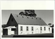
Cnr Brookman & Porter Sts Kalgoorlie
Registered as part of 1267
Kalgoorlie-Boulder
Goldfields
Constructed from 1895
| Type | Status | Date | Documents |
|---|---|---|---|
| (no listings) |
| Type | Status | Date | Documents |
|---|---|---|---|
| (no listings) |
| Type | Status | Date | Grading/Management | |
|---|---|---|---|---|
| Category | ||||
| Classified by the National Trust | Classified | 08 Mar 1976 | ||
| Register of the National Estate | Interim | 21 Mar 1978 | ||
01267 St Mary's Roman Catholic Church
Individual Building or Group
| Epoch | General | Specific |
|---|---|---|
| Present Use | VACANT\UNUSED | Vacant\Unused |
| Original Use | RELIGIOUS | Church, Cathedral or Chapel |
This information is provided voluntarily as a public service. The information provided is made available in good faith and is derived from sources believed to be reliable and accurate. However, the information is provided solely on the basis that readers will be responsible for making their own assessment of the matters discussed herein and are advised to verify all relevant representations, statements and information.
24 Brookman St Kalgoorlie
Cnr Brookman & Porter Sts
and original church site
Kalgoorlie-Boulder
Goldfields
Constructed from 1902
| Type | Status | Date | Documents |
|---|---|---|---|
| State Register | Registered | 21 Jan 1997 | HCWebsite.Listing+ListingDocument, HCWebsite.Listing+ListingDocument |
| Type | Status | Date | Documents |
|---|---|---|---|
| (no listings) |
| Type | Status | Date | Grading/Management | |
|---|---|---|---|---|
| Category | ||||
| Catholic Church Inventory | Adopted | 01 Jul 1998 | ||
| Classified by the National Trust | Classified | 08 Mar 1976 | ||
| Register of the National Estate | Interim | 21 Mar 1978 | ||
| Register of the National Estate | Registered | 21 Mar 1978 | ||
| Municipal Inventory | Adopted | 09 Jul 2001 | Category 1 | |
sound
| Library Id | Title | Medium | Year Of Publication |
|---|---|---|---|
| 5537 | St Mary's Church (1903), Kalgoorlie, Western Australia : conservation plan. | Heritage Study {Cons'n Plan} | 2002 |
Individual Building or Group
| Epoch | General | Specific |
|---|---|---|
| Original Use | RELIGIOUS | Church, Cathedral or Chapel |
| Present Use | RELIGIOUS | Church, Cathedral or Chapel |
| Style |
|---|
| Federation Gothic |
| Type | General | Specific |
|---|---|---|
| Roof | METAL | Corrugated Iron |
| Wall | BRICK | Common Brick |
| General | Specific |
|---|---|
| SOCIAL & CIVIC ACTIVITIES | Religion |
This information is provided voluntarily as a public service. The information provided is made available in good faith and is derived from sources believed to be reliable and accurate. However, the information is provided solely on the basis that readers will be responsible for making their own assessment of the matters discussed herein and are advised to verify all relevant representations, statements and information.
Constructed from 1902
Assessment of Significance: The building is a fine example of Federation Gothic ecclesiastic architecture enhanced by its finely crafted stone tracery and shafted jamb to the entrance and the rendered decorative treatment which enhances the brickwork. (Criterion 1.1) St Mary's Roman Catholic Church is a landmark in Kalgoorlie as a most imposing and decorative structure which contributes strongly to the visual character of Brookman Street. (Criterion 1.4) The church site has some historic value as a place of continuous worship since 1896, when the first Roman Catholic Church, one of the earliest in Kalgoorlie, was constructed. (Criterion 2.1) The construction of St Mary's Roman Catholic Church is closely associated with the rapid population growth in the eastern goldfields at the turn-of-the-century. (Criterion 2.2) St Mary's Roman Catholic Church is representative of tall and large-scale Federation Gothic ecclesiastic architecture. (Criterion 6.1) The additions to St Mary's Roman Catholic Church are a demonstration of the town's increasing prosperity and importance in the State. (Criterion 6.2) Statement of Significance: St Mary's Roman Catholic Church, a large, Federation Gothic style, brick and cement shingle covered church, has cultural heritage significance for the following reasons: - the place is a fine example of Federation Gothic ecclesiastic architecture; - the place is a landmark in Kalgoorlie as a most imposing and decorative structure; - the place contributes strongly to the visual character of Brookman Street; - the place is closely associated with the rapid population growth in the eastern goldfields at the turn-of-the-century; and - the church is a fine example of architectural design by Cavanagh and Cavanagh, who were responsible for the design of the majority of Catholic Church buildings in Western Australia at the turn-of-the-century. Although the adjacent parish centre, built in the 1970s, continues the long time use of this part of the site for parish purposes, it is considered of little significance.
St Mary's Roman Catholic Church is on the north-west corner of Porter and Brookman Streets and is built in the Federation Gothic style (Apperly et al, 1989: 120-123). The building is tall and large in scale. Adjacent is the parish centre built on the site of the original church constructed in 1896 (the date the original church was demolished is unknown, but National Trust of Australia (WA) documentation indicates the building was in existence in 1973). The building is in a bituminised setting with a carpark on the north side. An iron palisade fence on a brick plinth with brick piers extends the length of the boundaries of Brookman and Porter Streets. The building is cruciform in plan, with porticos to the northern and southern transept, and a nave conventionally orientated east-west with a polygonal apse. A tower and font allowed for in the design were not constructed. The red Coolgardie brick building has tall walls supported by corbelled buttresses at regular centres around the building (two buttresses on the south elevation are constructed to accommodate additions). At the corners of the building the corbelled buttresses are extended above the gables to form turrets. The corbels of the buttresses are accentuated by rendered small gables. The building has a rendered plinth which is ornamentally moulded, and the underside of the roof is finished with a rendered frieze consisting of dentils and small arches. There are tall lancet windows between each buttress. The building has a high-pitched gable roof with rendered gable ends and cement copings. The roof, originally covered with slate, is covered with cement shingles. The roof lacks ornamentation other than the rendered turrets at the gable ends, small decorative roof vents, and a rendered cross that decorates the apex of each gable. The walls are face brick laid in English bond. The nave is five bays long and the transepts one bay wide. The window in each bay of the nave contains two-light lancets with decorative plate tracery and a central top light, and defined by rendered reveals crowned with hood moulds. The detailing is typical of early English design and reminiscent of Castle Hall, Winchester. The transept gables and the western entrance have lancet windows grouped in five lights with bar tracery. The transepts feature small triple lancet windows. The windows are defined by rendered reveals crowned with hood moulds. The windows contain stained and leaded glass and the lower panes have pivot sashes. The exterior of the polygonal apse features a heavily moulded battlemented parapet that extends around the apse. The apse comprises five wide lancets, separated by buttresses that extend beyond the battlemented parapet. The lancets contain leaded and stained glass with the exception of the centre lancet which has plain glass. The windows have louvred screens secured over the windows on the exterior face. A pyramidal roof covers the apse. The entrance to the narthex features a pointed arch doorway with a shafted jamb. An ornamental masonry cross hangs above the doorway. The church interior is highly decorative. The roof is constructed of hammer beam trusses with carved timber rafters supported by rendered decorative timber brackets. The interior has timber floorboards and rendered walls. The interior of the narthex features timber panelled walls and ceiling. A carved timber stair leads to the upper gallery. The gallery is supported by timber columns and arches. The detailing is simple and elegant. The high altar is framed by two smaller altars within the transept; the altar of the Blessed Virgin on the east and the altar of the Sacred Heart on the west. The altars feature small recessed arches. The high altar is framed by a wide arch supported by a group of three columns with Corinthian capitals. The crossing features timber cross beams. The timber pews have carved tops at the aisle end. Although confessionals (on the west side of the transepts) appear on the original drawings, changes in bondwork suggest they are additions (Western Argus, 21 October 1902: 23). External window protection has been installed in recent times to protect the stained glass windows from vandalism. The windows are covered by white wire mesh, set into a light weight frame and fixed to the outside of the brickwork.
St Mary's Roman Catholic Church is an imposing brick and cement shingle covered building (the original roofing material was slate), constructed in 1902 to replace the inadequate original corrugated iron church structure built in 1896. In Kalgoorlie, all the major Christian denominations set about building substantial places of worship as soon as a congregation could be mustered. With a high percentage of early settlers either Irish born or of Irish descent, Roman Catholicism was prominent on the goldfields. Bishop Matthew Gibney made frequent visits to the goldfields. Kalgoorlie's original Catholic Church was opened on 17 March 1896, having been built at a cost of £1,081 (Webb, 1993: 551). In all, eight churches were built in the early years. They were all located within a few hundred yards of the junction of Maritana and Hannan Streets. By 1901, there were 27 churches and 15 other places of worship (Webb, 1993: 553). By the early 1900s, the original Catholic Church had become inadequate and plans were underway for the construction of a new larger church. The contract for the building was let to Mr S. Campbell of Subiaco under the supervision of joint architects Messrs Hawkins & Sprigg (Kalgoorlie) and Messrs M. F. & J. C. Cavanagh (Perth). The Western Argus reported on its progress: "Unquestionably the new church for the Roman Catholic Community, now in the course of erection, will when completed, be the most pretentious piece of ecclesiastical architecture to be seen locally. The building, which is designed in the form of a Latin Cross, is being constructed of red Coolgardie brick. Its length is 127ft. while the width across the nave is 37ft and 70ft. at the transepts. The sanctuary is finished with an apsidal end. On each side of the High Altar are two smaller ones. The Altar of the Blessed Virgin on the right and the Altar of the Sacred Heart on the left. At the back of these are the sacristy and the working sacristy, and facing the Altars on each side of the transepts are the confessionals. The style of architecture is Gothic, simple and attractive, of the decorated early English Period. In the completed design a tower and spire on the North Western angle is provided, as well as a baptistery, but at present it is not intended to carry out this part of the plans. The Western and the transept gables are to have five light windows, while the jambs, arch, Mullions, and tracery are to be of Sydney freestone. The whole will be covered by a slate roof. ... The cost of the completed design will be about £7,000" (Western Argus, 21 October 1902: 22-23). The original church remained in use, being used as the church hall until the early to mid-1970s, when it was demolished to make way for the construction of a new Parish Centre. In March 1996, the centenary of the Roman Catholic Church in Kalgoorlie was marked by the unveiling of a special stained glass window in St Mary's Roman Catholic Church by the Archbishop of Perth, the Rt. Rev. Barry James Hickey. Local artist Deborah Francis was commissioned by the Church to create the window, which reflects where the Church has come from with sections featuring old buildings and old mining activities and flora and fauna from the Goldfields region (Goldfields Magazine, 23 February 1996: 10).
Integrity: High Authenticity: High
Good
| Name | Type | Year From | Year To |
|---|---|---|---|
| Cavanagh and Cavanagh and Hawkins and Sprigg | Architect | 1902 | - |
| Ref ID No | Ref Name | Ref Source | Ref Date |
|---|---|---|---|
| Magazine Article p 10 | Goldfields Magazine | 23 February 1996 | |
| "Newspaper Article". pp. 22, 23 | Western Argus | 21 October 1902: | |
| Webb M; "Golden Destiny: The Centenary History of Kalgoorlie–Boulder and the Eastern Goldfields of Western Australia". p. 553 | City of Kalgoorlie-Boulder | 1993 |
| Owner | Category |
|---|---|
| Roman Catholic Church | Church Property |
This information is provided voluntarily as a public service. The information provided is made available in good faith and is derived from sources believed to be reliable and accurate. However, the information is provided solely on the basis that readers will be responsible for making their own assessment of the matters discussed herein and are advised to verify all relevant representations, statements and information.
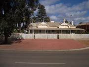
46 Brookman St Kalgoorlie
cnr Maritana St & Brookman Sts
Kalgoorlie-Boulder
Goldfields
Constructed from 1896 to 1970
| Type | Status | Date | Documents |
|---|---|---|---|
| State Register | Registered | 12 May 2000 | HCWebsite.Listing+ListingDocument, HCWebsite.Listing+ListingDocument |
| Type | Status | Date | Documents |
|---|---|---|---|
| (no listings) |
| Type | Status | Date | Grading/Management | |
|---|---|---|---|---|
| Category | ||||
| Register of the National Estate | Permanent | 21 Mar 1978 | ||
| Classified by the National Trust | Classified | 08 Mar 1976 | ||
| Municipal Inventory | Adopted | 09 Jul 2001 | Category 1 | |
| Name | Type | Year From | Year To |
|---|---|---|---|
| Henry L Brookman & Harvey Draper | Architect | - | - |
| Porter & Thomas | Architect | - | - |
| Library Id | Title | Medium | Year Of Publication |
|---|---|---|---|
| 6529 | Hannans Club, 44 Brookman Street, Kalgoorlie : conservation plan. | Heritage Study {Cons'n Plan} | 2003 |
| 11448 | Hannans Club: 44 Brookman Street, Kalgoorlie Conservation Management Strategy | Electronic | 2014 |
| 9336 | Hannans Club conservation works cnr Brookman and Maritana Street, Kalgoorlie | Conservation works report | 2009 |
Individual Building or Group
| Epoch | General | Specific |
|---|---|---|
| Present Use | SOCIAL\RECREATIONAL | Other Community Hall\Centre |
| Original Use | SOCIAL\RECREATIONAL | Other Community Hall\Centre |
| Style |
|---|
| Federation Arts and Crafts |
| Type | General | Specific |
|---|---|---|
| Roof | METAL | Corrugated Iron |
| Wall | STONE | Other Stone |
| General | Specific |
|---|---|
| SOCIAL & CIVIC ACTIVITIES | Community services & utilities |
This information is provided voluntarily as a public service. The information provided is made available in good faith and is derived from sources believed to be reliable and accurate. However, the information is provided solely on the basis that readers will be responsible for making their own assessment of the matters discussed herein and are advised to verify all relevant representations, statements and information.
Constructed from 1896 to 1970
: Assessment of Significance: Hannans Club, constructed in the Federation Arts and Craft style, has considerable aesthetic appeal, which is enhanced by the size of the building, the stone construction, the multigabled roof and its open street corner setting. (Criterion 1.1) Hannans Club demonstrates significant creative and design excellence in the 1896 partition wall in the members’ room and the 1899 billiard room design and detail. (Criterion 1.2) Hannans Club is significant in the Maritana Street streetscapes as it complements the broad street with the expansive lawned area framing the vistas. On the Brookman Street frontage, the formal entry and plantings contribute to the streetscape of the otherwise commercial area. The place makes a significant contribution to the townscape and character of the city of Kalgoorlie. (Criterion 1.3) The construction of Hannans Club was a result of the successful exploitation of the Eastern Goldfields and the continuing development of Kalgoorlie as the major administrative and commercial centre of the goldfields. (Criterion 2.1) Hannans Club was the first of three clubs established in Kalgoorlie in the 1890s. (Criterion 2.2) Hannans Club was one of the earliest substantial constructions in stone or brick in Kalgoorlie, at a time when most other buildings were still being constructed in timber and iron. (Criterion 2.2) Hannans Club was constructed as gentlemen's club. The changes that have taken place in society, and in the needs of members, have been reflected in the structural changes made to the place. (Criterion 2.2) Hannans Club was built at a time when women took a subordinate role in public life, and when middle class women were not employed outside the home. The changes that have taken place in society have been reflected in the membership of Hannans Club with the acceptance of the first female member in 1982. (Criterion 2.2) Hannans Club is associated with William Brookman and Charles de Rose who were involved in the development of the gold mining industry on the Golden Mile, and in development in the town of Kalgoorlie, and who offered to build the place. The members of Hannans Club were some of the most influential men in goldfields industrial and political life. (Criterion 2.3) The place is a fine example of the work of Kalgoorlie architects H L Brookman and Harvey Draper. (Criterion 2.3) Hannans Club is valued by the local community for its ongoing social associations, its connection with Kalgoorlie's gold boom past, and for its considerable aesthetic appeal. The place is highly valued by its members. (Criterion 4.1) Hannans Club contributes to the local and wider community's sense of place as a substantial reminder of the 1880s and 1890s gold rushes in Western Australia, as a distinctive element of the streetscape, and as a reminder of past attitudes and way of life. (Criterion 4.2) Hannans Club is a rare extant example of a fine gentlemen's club which has continued to operate since its establishment during the gold rushes in Kalgoorlie in 1896. (Criterion 6.1) Hannans Club is a fine representative example of the Federation Arts and Craft style of architecture. (Criterion 6.1) Hannans Club is a representation of the growing goldfields population and the need to establish community groups. It represents the principal characteristics of the distinctive function of a gentlemen's club, and informs of the changes that have taken place over time to accommodate the changing needs of that function. (Criterion 6.2) Statement of Significance: Hannans Club, a single-storey stone (1896) and brick (1899, 1904-05, 1971) building with an iron roof, and adjacent double storey squash courts (1939, 1979), in the Federation Arts and Craft style and located on the west corner of the intersection of Maritana and Brookman Streets, Kalgoorlie, has cultural heritage significance for the following reasons: - the place was the first gentlemen's club established in Kalgoorlie and its members were some of the most influential men in goldfields industrial and political life. The place is illustrative of the cultural history of a gentlemens’ club and the response to social changes over the years; - the place is significant as a fine example of Federation Arts and Crafts style architecture. Its aesthetic appeal is enhanced by the size of the building, the stone construction, the multi-gabled roof and its open street corner setting; - the place was one of the earliest substantial constructions in stone or brick in Kalgoorlie, at a time when most other buildings were still being constructed in timber and iron, and is an example of the use of local stone; - the construction of the place is representative of the successful exploitation of the Coolgardie Goldfields and the continuing development of Kalgoorlie as the major administrative and commercial centre of the Eastern goldfields; - the place contributes to the local and wider community's sense of place as a substantial reminder of the 1880s and 1890s goldrushes, a period of growth and development, in Western Australia; and, - the place is a fine example of the work of Kalgoorlie architects H L Brookman and Harvey Draper.
Hannans Club is located on the west corner of the intersection of Maritana and Brookman Streets, one street north of Hannan Street, in Kalgoorlie. The building presents a long elevation to Maritana Street, framed by an expanse of bowling green. The building addresses the corner with a truncated gable, and the main entry is on Brookman Street. A white gothic picket fence delineates the two street boundaries except at the formal entry, which is marked by a concave curved decorative wrought iron fence either side of a central gate flanked by square timber posts. The gateway is directly aligned with the pathway that leads to the main entry of Hannans Club. The Brookman Street frontage is a level grassed area with palms planted symmetrically each side of the vehicular entry gate, and more informally along the left side of the property. The rear of the property is levelled gravel providing for informal parking and services. Hannans Club displays characteristics of the Federation Arts and Craft style (Apperly et al, 1989: 140-143). The 'in-the-round' original building was typically sited in a picturesque setting with a formal entry ('in-the-round' is a term used in Apperly et al (1989: 143) to describe buildings which are not merely facades, but whose style is applied to the whole external structure). The conspicuous roof has prominent gables, and roughcast infills. The place is typified by the art nouveau interior detailing. Regional variations of the style include corrugated iron roof and the use of local Bulla Bulling weathered granite for the construction. The 1896 section of the building forms all of the Maritana Street frontage and part of the Brookman Street frontage. This part of the structure is distinguished by the corrugated iron hipped roof with a series of four gable features including the truncated corner facing the street corner. Each gable has a roughcast infill with detailed timber barge boards and finials above the recessed stone wall of the building structure. The right gable roof on the Maritana Street frontage features a tall corbelled brick chimney (painted) central within the roof ridge. The right gable has a circular galvanised steel vent. The verandah along the two street frontages has a concrete floor and 100mm square timber posts on exposed concrete pads supporting the bullnose verandah roof. The truncated corner has a parapet sign stating 'Hannans Club Ltd'. The Maritana Street verandah is wider than the Brookman Street verandah. The original 1896 stone walls have been painted. Along the Maritana Street frontage, the gables align with the protruding bays below. Central within each of the two bays is the fireplace flanked each side by a single double hung sash window. In the recessed sections of the walls, there are two sets of French doors with fanlights. The truncated corner has a set of two double hung windows, and the front window of the Long Room, facing Brookman Street, features a bay window with a set of three windows. The other 1896 windows on that frontage, left of the front door are single double hung sashes, while later windows across the face are two sets of two double hung sashes. The left front of the Brookman Street facade is painted brick, laid in English bond, with some evidence of tuck-pointing. Around the corner new semi-glazed panelled foldadoors have been installed, and a brick extension has been added to the back bar facility. The brickwork in the extension has been laid in English bond to a height of 2.00 metres with a hardiflex infill above to align with the bullnose roof. The remainder of the external fabric of the building remains unpainted. The only original stone fabric revealed on the exterior is the rear wall of the library. There is evidence of a former opening in the wall that has been infilled with bricks, quoined into the stone wall. A corbelled chimney above suggests that a fireplace has since been installed. The 1904-05 extension is constructed in Flemish bond brickwork. There is evidence of fabric having been removed along the rear wall. The Billiard Room has a hipped roof with vented gablets on the truncated corners. The chimneys are corbelled in a similar manner to the painted 1896 chimneys on the original section of the building. The external walls of the Billiard Room are entirely face brick laid in a Flemish bond with a double corbelled course at window head height around part of the perimeter, and a section of parapet wall adjacent to the open corridor parallel with the kitchen. The windows have rendered reveals and sills. At the rear of the site, the squash courts are double-storey height. The Maritana Street facade and the wall facing the rear of the club is painted brick, and the remainder of the building is face brick. The building has a corrugated iron clad gable roof. The gable infills are hardiflex sheeting and the Maritana Street gable has retained the original 1939 vented infill. The 'front' facade shows evidence of the infill of windows and walls. The exterior brickwork of the 1939 building has external engaged piers along the side walls. Similarly the 1979 addition, constructed in long format bricks, has external engaged piers. At the formal entry into Hannans Club, on Brookman Street, a set of panelled doors with sidelights and fanlight, open into the entry lobby. The lobby has a pressed metal dado wall and a ripple iron ceiling. On the left, a fixed glazed infill panel has replaced the original door opening into the office. The original timber and glass double front doors lead into the original 1896 hallway. The walls have the original art nouveau design pressed metal dado with studded timber trim. The original ceiling has been removed and replaced with acoustic plaster panels. On the right is the Long Room. It has the same dado detail as the hallway. The ceiling is panelled in a geometric square and rectangular design with a series of square roses along the centre of the room, and a decorative cornice. The cornice detail corresponds to the centre wall indicating that the ceiling has been redone since the Long Room was extended. There are recent suspended light fittings and c.1950s ceiling mounted fluorescent tubes in place. The 0.100 metre floorboards are probable replacements. The original fireplace and black marble mantelpiece (possibly original) are in place, although the grate is face brick with a concrete hearth. The wall between the Long Room and the library is richly detailed. A central door opening (closed off) with timber detailed pediment is flanked by timber panelling above the pressed metal dado. The entire wall is detailed within a flat arch with timber pilasters either side. The top of the arch is infilled with art nouveau design stained glass panels. The library was inaccessible during the inspection for this report, but from a view through the semi glazed panel door, appeared to have the same ceiling, wall and floor details as the Long Room, and the original fireplace was operational. The door on the left of the hallway has a four paned fanlight above. The door is the original semi-glazed door with the top panels infilled with frosted glass with the Hannan's Club insignia, comprising the two initial letters, etched on each pane. The door opens into the lounge bar area. There is minimal evidence of any original fabric in the lounge bar area as a result of refurbishment in recent years. The ceiling shows the changes. Central within the space are two timber boxed structural supports. Double hung sash windows are in place across the front of the room, and recent doors with fixed fanlights have been installed in the end wall. On the left is the entry into the office. An original fireplace in the lounge bar is the only evidence of the 1896 secretary's room. On the right is an entry door into the men's toilets. Further down the hallway, is a moulded arch with a decorative fretwork timber and glass infill. Beyond the arch, is a door on the left that leads into the lounge bar. Next to that door is another door into the ladies toilet. Both doors are four panelled doors with no fanlights above. On the right is another door into the Long Room that originally opened into the original billiard room (now the Library) before the panel wall was relocated. Another moulded arch in the hallway, with a flat arch and no infill, marks the end of the original 1896 fabric. Immediately on the right is a door into the library. On the left is a corridor, which leads to a door at the end. On the right of the corridor is one of the 1904-05 card rooms. The card room is intact. It has pressed metal dado walls with a plain jarrah trim. The pressed metal design is an intricate geometric design centred around a star. The ceiling is pressed metal, and the original cornices with corner details are intact. A c.1930s ceiling fan is suspended from the centre ceiling, and modern light fittings are attached to suspended light fittings. A circular air vent is in place on the wall. The original fireplace and circular marble mantelpiece is intact insitu (unable to photograph due to the amount of material stored in the room). The next room on the right, originally another card room, has been refitted as a kitchen. It has glazed ceramic tiled walls, cement floor and a stainless steel fitout. A door accesses the rear of the building and freestanding cool rooms in that vicinity. On the left of the corridor is evidence of an 1896 window that has been closed over. A door on the left accesses the men's toilets. The 1899 Billiard Room is accessed from behind the bar in the lounge bar area, or from an external corridor alongside the kitchen, which has a door access into the area behind the bar. The entry is across a truncated corner of the L- shaped room with truncated corners. Immediately left of the entry, central within the wall, is a black marble mantelpiece around the fireplace. The floor steps down to the main level, the change signalled by an expansive flat moulded arch. The ceiling is plain plaster with a decorative cornice detail. The timber floors are covered with carpet. Along the right wall, the raised floor level area has a row of purpose built timber benches against the hard plaster wall with timber dado rail detail. Further along the right wall, is the truncated corner of the room, also with a raised floor level and signalled by a circular moulded arch. The corner has a central black marble fireplace flanked by a double hung sash window in each truncation. On the front wall of the truncated corner, the arch is flanked by a vertical format double hung sash window with ten pane sash in the top section. The glass has been painted. Left of the corner is another length of raised flooring with seating along its length. The end wall has two of the same vertical format windows. The truncated wall on the elbow of the L has an arched window detail, some of which has been boarded over. The main floor of the room has two original full size billiard tables in situ, at right angles to each other, one situated in each length of the L-shaped layout. Central above each table is a decorative recessed ceiling vent, from which billiard lighting is suspended. One table has the original square pyramidal lighting over the tables, and the other table has an unusual four light steel lighting fixture. At the rear of the Billiard Room, accessed from the left of the building, is the 1899 secretary's room, above the cellar. The original ceiling, walls and four panelled door are still in place although the room is in poor condition. The cellar, accessed from the opposite side behind the room, shows evidence of stone construction. From inside the cellar, it is possible to see the termite damage to the joists and floorboards of the secretary's room above. At the rear of Hannans Club is the double storey squash courts. The central entry at ground level is part of the 1979 fabric. It has a concrete floor, and enters into the 1979 squash court on the left, and up two steps to the 1939 court on the right. The upstairs entry is accessed by a 1979 steel staircase. The upstairs viewing area has a timber floor and what are probably the 1939 purpose built viewing seats. The courts both have timber floors, hard plaster walls to the court area, and painted face brick work above the court lines. The entire roof is a 1979 timber truss with exposed anticon sheeting. At the rear of the main building, behind the library, and adjacent to the 1939 squash court, is the 1939 shower cubicle and change rooms. The building has hard plaster walls, concrete floor curved at the wall edges, gyprock ceilings and a possible 1979 toilet and shower fitout. The original 1896 building remains largely intact. Evidence of the early extensions (1899) can be seen in the two rooms at the rear, and the Billiard Room. Further evidence of that period has been obliterated by more recent developments that have had minimal impact on the authenticity of the original fabric. The remaining fabric of the original 1896 building, the 1904-1905 extensions and the squash courts and change room (1939, 1979) have retained a high degree of authenticity.
Hannans Club is a single-storey stone, brick and iron building purpose built for use as a gentlemen's club in 1896 (the name does not have an apostrophe. See name on parapet of 1986 building, and King, 1996). Constructed to a design by Kalgoorlie architects H. L. Brookman and Harvey Draper, the place displays characteristics of Federation Arts and Craft style (Apperly, 1989: 140-143). The original construction was of stone, while major extensions carried out in 1899 were in brick. Numerous other changes have been made to the place over the years. Later additions included a bowling green (1905) and two squash courts (1939 & 1979). In June 1893, Paddy Hannan and his partners discovered alluvial gold thirty miles (48 kms) north-east of Coolgardie. A camp, known as Hannan's Find, quickly developed at the site, with bough huts and hessian and canvas structures erected along the edge of the track from Coolgardie. Many of these structures housed businesses to serve the prospectors who flocked to the area. Later that year, William Brookman and Sid Pearce located gold reefs three miles south of Hannan's Find, at what was to become Boulder. On 4 September 1894, Hannan's Find was declared the townsite of Kalgoorlie (Webb, 1993: 91; King, 1995: 15; Laurie, 1995: 2-4). Kalgoorlie grew rapidly, and most of the social life of the predominantly male population centred around the hotels, which in the early years were canvas and iron structures with primitive facilities. On 18 August 1895, Warden Maynard Jephson invited thirty-three 'leading men of the town' to a meeting 'for the purpose of forming a club', similar to those gentlemen's clubs already established in Perth. Jephson, an Oxford graduate, had been instrumental in the formation of the Coolgardie Club (1894-1916) when he was Mining Registrar at Coolgardie for a short time (King, 1996: 2-6). At the meeting, held on 19 August, it was decided that 'a club shall be formed to be called The Hannans Club', controlled by a limited liability company, The Hannans Club Pty. Ltd (King, 1996: 4). Charles de Rose and William Brookman offered to build suitable premises and lease them to the Club at an annual rental of ten percent of the capital cost. Brookman had acquired Lots 99 and 100, on the corner of Brookman and Maritana streets, from the Union Bank, which had purchased the lots at the first Kalgoorlie land sale, but had then built bank premises in Hannan Street. Title to both lots was transferred to de Rose in 1896, and later to the joint ownership of both men (C/T Vol. 68, Fol. 195 & 196, 26 July 1895, 7 August 1895, 27 August 1896 & 3 January 1898). Architects H. L. Brookman and Harvey G. Draper were commissioned to draw up plans for Hannans Club. Draper is recorded as practising at Kalgoorlie between 1897 and 1906, but Brookman is not listed in the Post Office Directory for Kalgoorlie. He is listed at the Weld Chambers, Perth in 1895, and at Ord Street, West Perth in 1898. His association with Draper may have been confined to Hannans Club (Morison, 1895-1910). Harvey Draper also designed the Classroom Block (1906) of Christian Brothers College, Kalgoorlie. The contractor engaged on Hannans Club, J. Pringle, began construction early in October 1896. The building was priced at £3,500, and was sited on Lot 100 (King, 1996: 9-10). Hannans Club was officially opened on 28 May 1896 with 27 members. "The opening of the Hannan's Club in Brookman Street, Kalgoorlie was celebrated on Thursday afternoon 28 May 1896. A large number of members assembled to take part in the proceedings… The President [Mr H. M. Jephson] occupied the chair... Both the visitors and the members were delighted with the club premises, which are the finest in the Colony, with the exception of the Weld Club. The building, which forms quite an architectural feature, is situated on a corner of Maritana & Brookman Streets and is built of stone and covered with an iron roof with spacious verandahs on three sides. The bays are very effectively treated mounted with gables and filled in with rough casting. The main entrance is from the front and opens into a 7ft hall, to the right is placed the Members Room 30ft x 20ft, enhanced by a very ornamental tile grate and marble mantelpiece. Adjoining is the billiard room 42ft x 20ft, providing for two tables, well lighted by two skylights and French casement doors. If required these rooms can be thrown into one by removing the parallel portions dividing them. On the other wing is conveniently arranged a stranger's room, secretary's room, card rooms, bar and bathroom. Below the bar there is a large cellar 20ft x 12ft. The building was erected from designs by Messrs Brookman and Draper, architects of Exchange Buildings, Kalgoorlie. The work was carried out by Mr. J. Pringle, contractor. Now that the adjoining block of land has been secured it is intended at once to erect stone quarters for the servants, lay down a tennis court and enclose the ground on three sides with an iron fence and the front with ornamental pickets" (Kalgoorlie Miner, 30 May 1898: 2). A fence of six to eight feet (size varies) was constructed, effectively shutting out prying eyes for the next ninety years. The servants quarters, however, were built in timber (not extant) (King, 1996: 15). When Hannans Club opened, staff comprised a secretary, chief steward, two waiters and a billiard marker. The first secretary was sixty-two year old Captain Arthur Mecham, son of landed Irish gentry. He had served in the British army at Crimea and was later aide-de-camp to Sir William Robinson when he was Governor of South Australia and Western Australia (King, 1996: 19-20). By November 1897, Hannans Club had 288 ordinary, and 279 honorary, members, made up of mine managers, company directors, bank managers, solicitors, doctors, accountants, sharebrokers and other professionals. Most members of the Kalgoorlie Stock Exchange were members of Hannans Club, and many of Kalgoorlie's streets are named for early members, among them: W. Brookman, H. G. Parsons, R. Hamilton, J. Wilson, R. Varden, A. King, S. E. Hocking, H. M. Butler, G. H. Nethercott, Z. E. Lane and W. R. P. Marmion (King, 1996: 2). Members of Hannans Club usually stayed at the Weld Club when in Perth, apparently believing that both clubs catered for 'men of some standing in the community', a criterion for membership of Hannans Club for many years (King, 1996: 21). Representatives of certain occupations were not admitted as members of the club. In 1937, a member of three years standing was asked to resign when he obtained a publican's licence, and it was 1950 before a person holding a publican's licence was granted membership (King, 1996: 119). In the 1890s, the growing number of members soon put a strain on the capacity of the building. Because the property was still leased from Brookman and de Rose, the Club did not want to spend money on extensions (King, 1996: 21, 40-41, 82). The adjoining Lot 101, which had been bought at the second Kalgoorlie land auction by A. J. Monger for £850 as a possible warehouse site, had been purchased by The Hannans Club Pty Ltd for £950 in July 1897 (C/T Vol. 85, Fol. 97, 11 June 1896 & 7 July 1897). The Club decided to commission architects Porter & Thomas to prepare plans for a separate building on the land. The plans included a new billiard room, secretary's room, storeroom and cellar. A loan for £1,500 was arranged with the Union Bank and the contract for the work was awarded to George Sara, with a price of £1,389-10-0. The new building was constructed in brick, and was designed to take an upper storey. An open passageway was left between the new building and the original building on Lot 100 (King, 1996: 40-42). As well as the new construction, repairs and alterations to the stone building were carried out, the cost of £493 being shared by the Club and the owners. The alterations included enlarging the members room (later called the smoking room and then the Long Room) by moving the partition down a few feet into the old billiard room. The smaller area became a writing and reading room (later called the Library). All the work was completed by the end of 1899 (King, 1996: 40-42). In 1900, two slate-topped English billiard tables were installed in the new Billiard Room, and an interesting system of 'ventilators' was designed to protect them. The ventilators consisted of long tunnels of galvanised iron that fed fresh air under the billiard tables to prevent condensation from damaging them (King, 1996: 49). Around this time, card playing was extremely popular and more space was always being sought by the players. To provide it, the bar room was first replaced with a servery. This was followed by the removal of the servery to a back room to allow the whole bar room to be used by the card players. A final alteration resulted in a partition being erected in the Library. In 1903, a new Secretary's room was constructed on Lot 101, the verandah was extended around the building as far as the commencement of the Billiard Room, and the office was enlarged (King, 1996: 48). In July 1904, The Hannans Club Pty Ltd purchased Hannans Club and land for £2,800 (C/T Vol. 221, Fols. 24 & 25 & Vol. 309, Fol. 46, 7 September 1904; King, 1996: 60). This led to a small flurry of work on the stone building. The verandah on the east side was widened, new ceilings were erected in the Library and the Long Room to match the earlier moved partition panel, and two new card rooms were built. This latter item no doubt resulted in the removal of the temporary partition in the Library which had been put in to accommodate the card players. The bowling green on Lot 99, the corner lot, was established and officially opened on 8 November 1905 (King, 1996: 71). While women were not admitted as members to Hannans Club, they did attend social activities at the place. Garden parties, an annual ball, and lawn tennis afternoons on a court set up on the bowling green, were well patronised (King, 1996: 73-93). The Club's finances were adversely affected by World War One, the depressed situation of the goldfields in the mid 1920s, and the Depression. The situation improved slightly in the late 1930s, and Hannans Club was painted inside and out (exterior of the stone building only). The kitchen, which had been established on a portion of the back verandah, was lined with plasterboard, new curtains and carpets were fitted, and septic sewerage installed. A squash court was constructed at the rear of Hannans Club, with shower cubicles and change rooms at the end of the east verandah. The court was opened in June 1939 (King, 1996: 121-134). The squash courts were well used by RAF members during World War Two, but rarely used afterwards. A squash club was established in the town and the court rented out to them. Membership fees were increased to twelve guineas for town members and six guineas for country members. Finances were still tight, however, and two stewards were retrenched in 1952. In 1953, Hannans Club hosted the 5th Empire Mining and Metallurgical Congress buffet dinner and dance, and in 1962 hosted the visiting English cricket team. In 1969, Hannans Club had a record 474 honorary members, mostly connected to mining and exploration companies working in the area. The following year there were 50 new members as a result of the nickel boom, but the main revenue supporting the Club was its bar sales (King, 1996: 140-190). In 1970, with a confidence engendered by the nickel boom, the Club commissioned architects Oldham, Boas, Ednie-Brown to draw up plans for the redevelopment of Hannans Club. The plans included residential units, a swimming pool and garden court, new centrally located kitchen, and a general upgrade of bar and function facilities. The residential units were to be situated on Lot 102, which the Club also owned and on which was situated a house occupied by the Manager of Hannans Club. Bank finance of $25,000 was arranged for the first stage of the work, which consisted of renovations to the bar, and new furnishings and air-conditioning. The work on the bar connected the two buildings (1896 and 1899) for the first time. The cost of the work was over budget by $6,000 and no further redevelopment was carried out. The Club was having trouble at this time financing minor work that was required by the Licensing Court, such as replacing the floor coverings in the kitchen. In 1974, the Club sold Lot 102 to the Mines Department for $16,000 (King, 1996: 204-208). In order to trade out of trouble, the Club encouraged companies to hold functions at Hannans Club, and emphasis shifted from the place operating as a mining club to a commercial club, with more relaxed membership rules. The Hannans Club and the Kalgoorlie Squash Club amalgamated and the male squash club members became members of Hannans Club. A new squash court was erected on the southern side of the existing court in 1979, at a cost of $28, 983. By the end of that year, however, with gold trading on the open market, the price of gold rose and the goldfields were set for another boom (King, 1996: 210-222). In 1978, Hannans Club was placed on the Register of the National Estate. An architectural assessment of the place by the Western Australian Heritage Committee was carried out in 1983, with the view to getting a grant for maintenance and repair work. In the final event, a grant was not applied for, but some of the maintenance and repair work recommended in the report was addressed. Major renovations were also carried out to the bar (King, 1996: 237-240; Molyneux and Associates, 1993). In 1988, the place was re-roofed at a cost of $34,000 (King, 1996: 247, 265). Since 1980, four of the five Club secretaries have been female, and on 16 December 1982, the first female member was admitted to Hannans Club (King, 1996: vii, 236). There had never been anything in the original constitution barring female members, but the general consensus had always been that men did not want their wives at the Club except for the social events. With the changing social situation came a changed approach. Some time between 1983 and 1987, the high fence protecting Hannans Club from the gaze of passers by was reduced in height by half. Many people discovered the existence of Hannans Club for the first time. Those who knew of it referred to it as the Mafia Club, not because they thought it was run by the Mafia, but because its members were perceived as the powerful decision makers of the town (King, 1996: 247, 265). In July 1995, membership fees were raised from $185 to $215 for town members and $100 to $120 for country members. There were then 210 town, and 110 country, members. In the 1990s, Hannans Club is in a sound financial situation. The place is the venue for seminars, meetings, private parties, conferences and other functions, including weddings. These functions are usually held in the Long Room. Barbecues are held on the lawn, previously the bowling green. In 1994, plans were put forward to enlarge and upgrade the kitchen facilities to assist in catering for the functions, but in 1999 this has still to be done (King, 1996: 257-274; Kalgoorlie Town Planning Committee meeting, 13 June 1994; physical evidence).
Integrity: High Authenticity: High
Fair - Good
| Name | Type | Year From | Year To |
|---|---|---|---|
| Porter & Thomas | Architect | - | - |
| H. L. Brookman and Harvey G. Draper | Architect | - | - |
| Ref ID No | Ref Name | Ref Source | Ref Date |
|---|---|---|---|
| Laurie, K; "Hannan Street, Kalgoorlie: Our Golden Heritage: a Heritage Walk Along Hannan Street". p.2-4 | Kalgoorlie-Boulder Tourist Centre WA and A Government of Western Australia | 1995 | |
| King, N; "The Hannans Club: The First 100 Years, 1896-1996," p.2-6, 9-10, 19-21, 40-41, 48, 82 119, 121-134, 210-222, 237, 247-265, | The Hannans Club, Kalgoorlie | 1996 | |
| "Newspaper Article". | Kalgoorlie Miner | 30 May 1898 | |
| Webb M; "Golden Destiny: The Centenary History of Kalgoorlie-Boulder and the Eastern Goldfields of Western Australia". p. 91 | City of Kalgoorlie-Boulder | 1993 |
| Owner | Category |
|---|---|
| The Hannan's Club Ltd | Other Private |
This information is provided voluntarily as a public service. The information provided is made available in good faith and is derived from sources believed to be reliable and accurate. However, the information is provided solely on the basis that readers will be responsible for making their own assessment of the matters discussed herein and are advised to verify all relevant representations, statements and information.
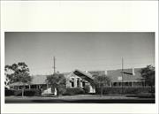
24 Dugan St Kalgoorlie
cnr Dugan & Cassidy Sts
Kalgoorlie-Boulder
Goldfields
Constructed from 1900
| Type | Status | Date | Documents |
|---|---|---|---|
| State Register | Registered | 29 Sep 1998 | HCWebsite.Listing+ListingDocument, HCWebsite.Listing+ListingDocument |
| Type | Status | Date | Documents |
|---|---|---|---|
| (no listings) |
| Type | Status | Date | Grading/Management | |
|---|---|---|---|---|
| Category | ||||
| Municipal Inventory | Adopted | 09 Jul 2001 | Category 1 | |
| Classified by the National Trust | Recorded | 21 Oct 1973 | ||
| Name | Type | Year From | Year To |
|---|---|---|---|
| John Grainger PWD | Architect | - | - |
| George Temple Poole PWD | Architect | - | - |
| Hillson Beasley PWD | Architect | - | - |
| Library Id | Title | Medium | Year Of Publication |
|---|---|---|---|
| 3204 | Historic Kalgoorlie Boulder Schools - Preliminary Heritage Assessments | Heritage Study {Other} | 1997 |
Individual Building or Group
| Epoch | General | Specific |
|---|---|---|
| Original Use | EDUCATIONAL | Primary School |
| Present Use | EDUCATIONAL | Primary School |
| Style |
|---|
| Federation Arts and Crafts |
| Type | General | Specific |
|---|---|---|
| Roof | METAL | Corrugated Iron |
| Wall | STONE | Other Stone |
| General | Specific |
|---|---|
| SOCIAL & CIVIC ACTIVITIES | Education & science |
This information is provided voluntarily as a public service. The information provided is made available in good faith and is derived from sources believed to be reliable and accurate. However, the information is provided solely on the basis that readers will be responsible for making their own assessment of the matters discussed herein and are advised to verify all relevant representations, statements and information.
Constructed from 1897, Constructed from 1912
Assessment of Significance: Kalgoorlie Primary School has aesthetic value as a complex of two fine Federation Arts and Crafts buildings in an open landscape setting. (Criterion 1.1) Kalgoorlie Primary School is representative of the development and rapid growth of primary schools in the Eastern Goldfields following the first gold discoveries in the mid-1890s. The place was the first Government primary school building in Kalgoorlie. (Criterion 2.2) Kalgoorlie Primary School is associated with Government Architects George Temple-Poole, John Grainger and Hillson Beasley, who were responsible for many of the era's public buildings. (Criterion 2.3) Kalgoorlie Primary School is also associated with a number of notable teachers and students, including student Wallace Kyle, who later became Governor of Western Australia. (Criterion 2.3) Kalgoorlie Primary School is valued by the people of Kalgoorlie for providing a sense of place and for its educational and social associations. (Criteria 4.1 and 4.2) Kalgoorlie Primary School is one of the most architecturally complex school buildings of its era. The place is also unusual in that the school's pattern of growth over time is highly legible in the finishes and details. (Criterion 5.2) Kalgoorlie Primary School is representative of the development and rapid growth of primary schools in the Eastern Goldfields. (Criterion 6.2) Kalgoorlie Primary School is representative of the school design work of Government Architects George Temple-Poole, John Grainger and Hillson Beasley. (Criterion 6.2) Statement of Significance: Kalgoorlie Primary School, comprising the Senior School and Infants' School, two single-storey stone school buildings with gabled roofs in the Federation Arts and Crafts style, has cultural heritage significance for the following reasons: - the place has aesthetic value as a complex of two fine Federation Arts and Crafts buildings in an open landscape setting; - the place was the first Government school building in Kalgoorlie and is associated with Government Architects George Temple-Poole, John Grainger and Hillson Beasley, and former student, Wallace Kyle, Governor of Western Australia; - the place provides a sense of place to the people of Kalgoorlie, generations of whom commenced their education there; - the place is representative of the development and rapid growth of primary schools in the Eastern Goldfields and is one of the more complex examples of its type. The finishes and internal design fit-out of the administration area of the Senior School, and the air conditioning in the Infants' School, are considered to be intrusive. Other buildings on the site are considered to have little heritage significance.
: Some re-modelling has occurred, particularly in the entry area of the Senior School. For a discussion of the physical evidence, refer to Considine et al, 1997.
For a discussion of the documentary evidence, refer to Considine et al, 1997.
Integrity: High Authenticity: Moderate to High
Fair
| Name | Type | Year From | Year To |
|---|---|---|---|
| Hillson Beasley (PWD) | Architect | - | - |
| John Grainger (PWD) | Architect | - | - |
| George Temple Pool (PWD) | Architect | 1897 | - |
| Owner | Category |
|---|---|
| Education Department | State Gov't |
This information is provided voluntarily as a public service. The information provided is made available in good faith and is derived from sources believed to be reliable and accurate. However, the information is provided solely on the basis that readers will be responsible for making their own assessment of the matters discussed herein and are advised to verify all relevant representations, statements and information.
45-47 Dugan St Kalgoorlie
Residences, 45 & 47 Dugan Street
Kalgoorlie-Boulder
Goldfields
Constructed from 1898 to 1994
| Type | Status | Date | Documents |
|---|---|---|---|
| State Register | Registered | 12 May 2000 | HCWebsite.Listing+ListingDocument, HCWebsite.Listing+ListingDocument |
| Type | Status | Date | Documents |
|---|---|---|---|
| (no listings) |
| Type | Status | Date | Grading/Management | |
|---|---|---|---|---|
| Category | ||||
| Register of the National Estate | Permanent | 21 Mar 1978 | ||
| Classified by the National Trust | Classified | 06 Sep 1976 | ||
| Municipal Inventory | Adopted | 09 Jul 2001 | Category 1 | |
Individual Building or Group
| Epoch | General | Specific |
|---|---|---|
| Present Use | RESIDENTIAL | Conjoined residence |
| Original Use | RESIDENTIAL | Conjoined residence |
| Style |
|---|
| Victorian Tudor |
| Type | General | Specific |
|---|---|---|
| Roof | METAL | Corrugated Iron |
| Wall | BRICK | Common Brick |
| General | Specific |
|---|---|
| OCCUPATIONS | Domestic activities |
This information is provided voluntarily as a public service. The information provided is made available in good faith and is derived from sources believed to be reliable and accurate. However, the information is provided solely on the basis that readers will be responsible for making their own assessment of the matters discussed herein and are advised to verify all relevant representations, statements and information.
Constructed from 1898
Assessment of Significance: Residences, 45 & 47 Dugan Street has aesthetic value as a fine and rare example of the Victorian Tudor style of architecture adapted for the Goldfields. (Criterion 1.1) Residences, 45 & 47 Dugan Street is a distinctive pair of semi-detached buildings in the streetscape and contributes to the identity of Dugan Street and to the townscape character of the town of Kalgoorlie. (Criterion 1.3) The construction of Residences, 45 & 47 Dugan Street in 1898, illustrates the rapid development of the town as an outcome of the prosperity resulting from the exploitation of the Eastern Goldfields in the 1890s. (Criterion 2.1) Residences, 45 & 47 Dugan Street is representative of the third phase of early construction in Kalgoorlie between c. 1898 and 1908, when substantial brick structures were built. The place was constructed to provided much needed accommodation in the Goldfields town. (Criterion 2.2) The changing use of Residences, 45 & 47 Dugan Street from largely residential to wholly commercial, is indicative of the growth of the town of Kalgoorlie. (Criterion 2.2) Residences, 45 & 47 Dugan Street was built for William Brookman and Charles de Rose who were involved in the development of the gold mining industry on the Golden Mile, and in development in the town of Kalgoorlie. (Criterion 2.3) Residences, 45 & 47 Dugan Street is valued by the local community for its connection with Kalgoorlie's gold boom past, for its aesthetic appeal, and its rarity value as the only pair of semi-detached buildings remaining of a group of four pairs. (Criterion 4.1) Residences, 45 & 47 Dugan Street contributes to the local and wider community's sense of place as a reminder of the 1880s and 1890s goldrushes in Western Australia, a period of prosperity, population growth and development, and as a distinctive element of the streetscape. (Criterion 4.2) Of a group of four pairs of semi-detached buildings in the Victorian Tudor style built at the same time in Dugan Street, Residences, 45 & 47 Dugan Street is the only pair remaining. (Criterion 5.1) The application of the Victorian Tudor style, particularly to a pair of semi-detached buildings, is rare in the Western Australian context. (Criterion 5.1) Residences, 45 & 47 Dugan Street is a fine example of a pair of semi-detached buildings demonstrating the characteristics of Victorian Tudor style. (Criterion 6.1) The pair of semi-detached buildings represents a distinctive way of life and land use in close proximity to the commercial heart of the gold mining town of Kalgoorlie. (Criterion 6.2) Statement of Significance: Residences, 45 & 47 Dugan Street, a pair of single-storey brick and iron, semi-detached buildings constructed in 1898 in the Victorian Tudor style, has cultural heritage significance for the following reasons: - the place has aesthetic value as a very fine, rare and substantially intact example of the Victorian Tudor style of architecture adapted for the Goldfields; - the construction of the place in 1898, illustrates the rapid development of the town as an outcome of the prosperity resulting from the exploitation of the Eastern Goldfields in the 1890s; - the place was built for William Brookman and Charles de Rose who were involved in the development of the gold mining industry on the Golden Mile, and in development in the town of Kalgoorlie; - the place contributes to the local and wider community's sense of place as a reminder of the 1880s and 1890s goldrushes in Western Australia, a period of prosperity, population growth and development; and, - the place is a distinctive element of the streetscape, and is valued for its rarity as the only pair of semi-detached buildings remaining of a group of four pairs.
Residences, 45 & 47 Dugan Street is located on a level site on the south east side of Dugan Street in Kalgoorlie. It is set back from the front boundary with a front garden comprising recent plantings amongst mulch, brick paved pathways and a mature Jacaranda tree central in the front setback. The rear of the property is accessed by a right of way, and the entire rear area is bitumenised. Residences, 45 & 47 Dugan Street shows some characteristics of the Victorian Tudor style, which was predominantly residential (Apperly, 1989: 86-89). Traditional load bearing masonry construction often incorporated battlemented parapets, bay windows, and verandahs in symmetrical designs. Residences, 45 & 47 Dugan Street is a pair of single storey brick and iron buildings, divided along their length by a parapet wall along the roof ridge. The roof has been reclad with long sheets of custom orb colorbond sheeting. The roof is highlighted by three distinctive chimneys, one central over the ridge, and the others symmetrical either side. The chimney stacks are laid in face brick stretcher bond and have moulded trims including a decorative rendered relief curved element on each corner. The predominantly hipped roof has distinctive bracketed eaves, a hipped gable at centre front, and a gable on each side elevation. The gables, all have reconstructed turned timber finials. The gables are face brick and the front gable features two vertical format louvred vents with stucco moulding. Below the front gable is a rendered castellated parapet extending from the bay windows. The symmetrical frontage is divided in the centre by the parapet wall, and each side is a mirror image in plan and elevation. Central on the front elevation is the gable, battlemented parapet, and bay windows, one each side of the central wall. A verandah extends across the entire front and down each side of the building. For clarity, the left side of the building will be described. Where there are differences with the mirrored image right side, it will be noted. The face brick work of the front walls under the verandahs is laid in a Flemish bond. The side walls are laid in English bond, and there is a cement render over the bricks to sill height along the walls. Across the front facades the original tuck pointing has been painted over. Recently some of the paint has been removed. The turned posts supporting the verandah have been reconstructed, and a concrete floor has replaced the original timber verandah floor. A small gable at the end of the verandah is aligned with the front entry door. The four panelled front door has sidelights and a fanlight which no longer have the original stained glass. Two sets of original French doors also open onto the front verandah. Residences, 45 & 47 Dugan Street in its entirety has been refurbished. Floors, ceilings, skirtings, architraves, ceiling roses, and windows have been restored. New internal doors are in place, and new hardware has been installed to all the doors. The front door opens into a small entry with a door on the right. The front room has the bay window, and a corner fireplace with the original mantelpiece. A decorative flat arch decorates the bay window opening. The original ceiling rose has been retained in the new ceiling. On the left of the entry is the corridor leading to the back door, with the party wall on the right. The first room on the left has had the corridor wall removed. That wall is intact in the other unit, but a small opening has been made instead between the entry and the room. The room is otherwise intact, with restored double hung sash windows with safety glass, and restored mantelpiece. The identical mantelpiece in the other unit has been painted. The corridor has decorative archways at two positions down its length. The next room on the left down the corridor is a treatment room. The ceiling is new, the fireplace boarded, and the fitout extends above the window opening with no intrusion to the original fabric. An original wall has been removed and a new stud wall has been inserted to increase the size of the room. The mirrored plan is intact. The next two rooms on the left are refurbished but retain the original fabric. In the third room, there is no internal evidence of the external chimney. The original fabric of the place finishes at the end of the corridor. The original back door with fanlight above, opens into a recently constructed brick and iron extension. The corridor continues to the rear of the building with the kitchen, bathroom and toilet facilities along the left side of the corridor. The layout of the extension differs slightly in the other unit.
: Residences, 45 & 47 Dugan Street is a pair of single-storey brick and iron, semi-detached buildings, constructed in 1898. The place was designed by local architect D. T. Edmunds, and shows characteristics of the Victorian Tudor style adapted for the Goldfields. Residences, 45 & 47 Dugan Street was one of four semi-detached buildings, situated on adjoining lots. The other three are no longer extant, and were probably demolished in the 1970s. The place was renovated in 1994, and is occupied as a dental surgery and offices. In June 1893, Paddy Hannan and his partners discovered alluvial gold thirty miles (48 kms) north-east of Coolgardie. A camp, known as Hannan's Find, quickly developed at the site, with bough huts and hessian and canvas structures erected along the edge of the track from Coolgardie. Later that year, William Brookman and Sid Pearce located gold reefs three miles south of Hannan's Find, at what was to become Boulder. On 4 September 1894, Hannan's Find was declared the townsite of Kalgoorlie. The track from Coolgardie became the main street and was named Hannan Street (Webb, 1993: 91; King, 1995: 15; Laurie, 1995: 2-4). Housing for the miners and others who came to the district consisted of similar bough, hessian and canvas structures, which were erected wherever there was space. As the townsite grew these structures were replaced with iron and timber, and then brick houses. The supply of housing could not keep up with demand however, and land in Kalgoorlie was expensive. Among the land released for sale from the first town survey were eight lots on Dugan Street, Lots 111-118, which were purchased by William Gordon Brookman and Charles Henry de Rose in 1896 (C/T Vol. 81, Fol. 133, 14 April 1896 & Vol. 221, Fols. 4 & 5, 21 May 1901). In October 1898, the following newspaper item appeared: "A long felt want is about to be supplied in the town by the erection of a number of stone and brick cottages or villas, for leasing. Messrs Brookman and De Rose who own a large number of town blocks, have made a start in this direction by letting a contract for the erection of four semi-detached villas in Dugan Street. The contract has been secured by Messrs J. V. Mills and Co, who will make a start on the buildings on Monday. The cottages will be situated immediately opposite the State School in Dugan Street, and the first part of the work comprises four houses and it is probable a much larger number will be put in hand almost at once. Already several enquiries have been made from the architect Mr. D. T. Edmunds, from people wishing to rent the villas and two out of the four have been bespoke. There is a big demand for nicely furnished cottages within reasonable distance of the business centre of the town and no doubt sufficient inducement will be offered to Messrs Brookman and De Rose to continue building till the whole of the ground between Cassidy and Maritana Streets has been covered with dwellings (Western Argus, 13 October 1898: 15). The four pairs of semi-detached buildings constructed at this time were the only ones built on the land however. Residences, 45 & 47 Dugan Street was sited on Lot 113, third in line from the right. The date of completion is not clear. Three were occupied by 1901, and the fourth first appears in 1902 (Wise's Post Office Directories, 1989-1902). Residences, 45 & 47 Dugan Street was one of the first buildings constructed. Architect D. T. Edmunds was also responsible for the York Hotel (1900) and the City Markets (1901) on Hannan Street (King, 1995: 548, 583). William Brookman's financial affairs may have had something to do with the fact that no more residences were built on this land. His lavish lifestyle, which included a sea-going yacht, a two-storey mansion in Adelaide Terrace, a farm at Cannington, a seaside residence at Mandurah, and a coach attended by liveried footmen, left him bankrupt by 1903. Originally from Adelaide, his brother George, (later Sir George), had sent him and Sid Pearce to investigate the West Australian goldfields after the finds at Coolgardie (King, 1995: 15; King, 1996: 56-58; Webb, 1993: 247-248, 286-287). Following their discovery of the Boulder reefs, William, and partner and school friend, Charles de Rose, became big investors in Kalgoorlie property. They were also the original owners and developers of Hannans Club (1896). William Brookman left Kalgoorlie to live in Perth, and was mayor of Perth for eight months in 1900, as well as a member of the Legislative Council for the Metropolitan -Suburban Province from 29 August 1900 to 15 December 1903, when his seat was declared vacant through non-attendance. In 1904, ill and with his fortune gone, he returned to Adelaide to live with relatives until his death in 1910 at the age of forty-seven (King, 1995: 15; King, 1996: 56-58; Webb, 1993: 247-248, 286-287). Charles de Rose had returned to Adelaide to live with his wife and family about 1900, having made a substantial fortune. Both his and Brookman's affairs in Kalgoorlie were handled at that time by T. F. Brimage and Co. De Rose lived at Adelaide until his death in 1957, at the age of ninety-five (King, 1995: 15; King, 1996: 56-58; Webb, 1993: 247-248, 286-287). Occupancy of Residences, 45 & 47 Dugan Street changed rapidly in the early years. In 1902, Residences, 45 & 47 Dugan Street was occupied by dentist Ralph Potts, and James Brennan, of Brennan Brothers, merchants of Hannan Street. For a few years, from 1903, medical practitioner, G. A. Kearney occupied half of Residences, 45 & 47 Dugan Street. Tenancy of the other semi-detached residences also changed regularly, and they were often occupied by women, whose occupations are not listed. Between 1904 (when street numbering first appears) and the late 1930s, the semi-detached residences were numbered 73-87 Dugan Street. Until 1910, they were the only buildings on the block between Cassidy and Maritana Streets, except for plumber Claude Gregory, who occupied the Maritana Street corner site (Wise's Post Office Directories, 1900-1940). Most of this land was still owned by Brookman and de Rose. In 1915, three of the four pairs of semi-detached buildings, those on Lots 111-113 and including Residences, 45 & 47 Dugan Street, were purchased by Janet Fyfe Walsh (C/T Vol. 621, Fol. 180, 24 June 1915). The buildings continued to be rented out. That year, Mrs Edward Rice was running a lodging house in Residences, 45 & 47 Dugan Street, at No. 77 (45), while Edward Rice is listed as residing in the residence next door at No. 75 (43), and another lodging house was operating at No. 73 (41), run by Mrs Treloar. Mrs Rice's lodging house was still operating in Residences, 45 & 47 Dugan Street in 1920, but Edward Rice had moved on from the residence next door (Wise's Post Office Directories, 1915-1920). Nos. 87 (55) and 77 (45) were vacant in 1925, which was probably a reflection of the depressed state of the goldfields, a situation which occurred following World War One (Wise's Post Office Directories, 1925). The following year, Residences, 45 & 47 Dugan Street and its two right hand neighbours were purchased by widow Janet Johnson, and three years later by Robert Bates (C/T Vol. 621, Fol. 180, 14 October 1962 & 2 January 1929). Tenancies continued as none of the owners occupied any of the semi-detached residences. A new house appeared on the vacant land on the corner of Cassidy Street, on the far right hand side of the residences, in 1930, and by 1935, there was a house on left hand side of the group as well. The street block quickly filled up over the next five to ten years (Wise's Post Office Directories, 1930-1945; sewerage plan, January 1940, supplied by the City of Kalgoorlie-Boulder). In the late 1930s, the street numbering changed, but it still did not quite match current numbering. Residences, 45 & 47 Dugan Street was numbered 49-51 at this time (Wise's Post Office Directories, 1930-1945. It is not known when street numbering changed to the present configuration). When Robert Bates died in 1945, his wife Helen inherited Residences, 45 & 47 Dugan Street, and its neighbours on Lots 111 & 112. In 1948, the three pairs of semi-detached residences were purchased by Jessie Blackmore who was residing at 45 Dugan Street at the time (but whether this was the current No. 45 is not known) (C/T Vol. 621, Fol. 180, 19 August 1948). In 1967, title for Residences, 45 & 47 Dugan Street was transferred to a separate certificate (C/T Vol. 27, Fol. 322A, 24 May 1967). Residences, 45 & 47 Dugan Street changed hands a number of time over the ensuing years, and may have been occupied as offices in the latter years (C/T Vol. 27, Fol. 322A, 22 January 1973; 24 November 1977; 11 February 1980; 13 October 1982; 12 February 1990; 17 October 1991). In 1996, Residences, 45 & 47 Dugan Street was purchased by Peter Dawson, dentist, of Kalgoorlie who proceeded to restore the place (C/T Vol. 27, Fol. 322A, 12 March 1996). "Peter and Anthea Dawson say there was plenty of heartache involved in restoring their Victorian duplex at 45/47 Dugan Street, but it was all worth it. For six months the Kalgoorlie couple, with the help of a variety of local tradespeople, worked non-stop on the ornate dwelling built in 1898 for William Brookman and Charles De Rose, members of one of the Golden Mile's early successful syndicates. The building … is the only remaining example of a substantial attached dwelling close to the commercial centre of Hannan Street, according to City of Kalgoorlie-Boulders Municipal Heritage Inventory. Most of the original brick-and-iron building remained when the Dawsons bought it earlier this year, but it was in a poor condition. They researched the duplex's history assisted by the knowledge of local identity Rip Hayhow. Also, they followed strict Heritage Council guidelines to restore it to as close to its original condition as possible. Their first step in achieving this, Anthea said, was to bring the building "back to basics". After that, there was a wealth of work to be done, including re-pointing exterior brickwork, re-roofing the building, painting the interior and replacing the old windows with security glass. Anthea said … 'It's a credit to the local tradesmen that this building looks so good and it's also a great credit to the people who built it originally.' The duplex now hosts Peter's dental surgery on one side - coincidentally, it is believed the second person to own the building was also a dentist - and a suite of offices on the other (Goldfields Magazine, 6 September 1996: 12-13). Other work carried out in the restoration included the re-laying of all the floorboards to remove built up dirt, damp proofing treatment (not successful to date), and removal of all extensions and outbuildings at the rear (information provided by Anthea Dawson at the time of the physical inspection). While it is not correct that Residences, 45 & 47 Dugan Street was previously owned by a dentist, it was occupied by dentist Ralph Potts, in 1902, and also by a doctor for a few years between 1903 and 1910. In August 1998, Residences, 45 & 47 Dugan Street was strata titled and Lot 113 was subdivided into Lots 1 and 2. Lot 1, No. 45, is owned by Peter Dawson and occupied by him as his dental surgery. Lot 2, No. 47, is owned by Kaldent Pty Ltd and is occupied as offices. The owners share common property at the rear of the lot (Strata Plan 34464, registered 20 August 1998, C/T Vol. 2140, Fols. 155 & 156, 20 August 1998).
Integrity: Low Authenticity: High
Good
| Name | Type | Year From | Year To |
|---|---|---|---|
| Daniel T. Edmunds | Architect | 1898 | - |
| Ref ID No | Ref Name | Ref Source | Ref Date |
|---|---|---|---|
| King N; "The Voice of the Goldfields: 100 Years of the Kalgoorlie Miner,". p.15 | Hocking and Co, Kalgoorlie. | 1995 | |
| Webb M; "Golden Destiny: The Centenary History of Kalgoorlie-Boulder and the Eastern Goldfields of Western Australia". p.247-248, 286-287 | City of Kalgoorlie-Boulder | 1993 | |
| King N; "The Hannans Club: The First 100 Years, 1896-1996,". p.56-58 | The Hannans Club, Kalgoorlie. | 1996 |
This information is provided voluntarily as a public service. The information provided is made available in good faith and is derived from sources believed to be reliable and accurate. However, the information is provided solely on the basis that readers will be responsible for making their own assessment of the matters discussed herein and are advised to verify all relevant representations, statements and information.
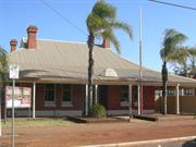
108-110 Egan St Kalgoorlie
The Kalgoorlie Country Club
Kalgoorlie-Boulder
Goldfields
Constructed from 1903
| Type | Status | Date | Documents |
|---|---|---|---|
| State Register | Registered | 17 Nov 2006 | HCWebsite.Listing+ListingDocument, HCWebsite.Listing+ListingDocument |
| Type | Status | Date | Documents |
|---|---|---|---|
| (no listings) |
| Type | Status | Date | Grading/Management | |
|---|---|---|---|---|
| Category | ||||
| Municipal Inventory | Adopted | 09 Jul 2001 | ||
The Kalgoorlie Club is in fair condition as a result of continued maintenance and care over the period of its history. The building is well cared for but is suffering from total failure of the roof drainage system, which is causing leakage through the box gutter along the spine of the building. There is also evidence of serious rising damp along the south western side of the building.
| Name | Type | Year From | Year To |
|---|---|---|---|
| Geofrey Hawkins and Sprigg | Architect | - | - |
| Library Id | Title | Medium | Year Of Publication |
|---|---|---|---|
| 7039 | Kalgoorlie Club, 108 Egan Street, Kalgoorlie : conservation plan. | Heritage Study {Cons'n Plan} | 2004 |
Individual Building or Group
| Epoch | General | Specific |
|---|---|---|
| Original Use | SOCIAL\RECREATIONAL | Other Community Hall\Centre |
| Present Use | SOCIAL\RECREATIONAL | Other Community Hall\Centre |
| Style |
|---|
| Federation Bungalow |
| Type | General | Specific |
|---|---|---|
| Wall | BRICK | Common Brick |
| Roof | METAL | Corrugated Iron |
| General | Specific |
|---|---|
| OCCUPATIONS | Hospitality industry & tourism |
| SOCIAL & CIVIC ACTIVITIES | Community services & utilities |
| DEMOGRAPHIC SETTLEMENT & MOBILITY | Depression & boom |
| SOCIAL & CIVIC ACTIVITIES | Sport, recreation & entertainment |
| OCCUPATIONS | Commercial & service industries |
This information is provided voluntarily as a public service. The information provided is made available in good faith and is derived from sources believed to be reliable and accurate. However, the information is provided solely on the basis that readers will be responsible for making their own assessment of the matters discussed herein and are advised to verify all relevant representations, statements and information.
This information is provided voluntarily as a public service. The information provided is made available in good faith and is derived from sources believed to be reliable and accurate. However, the information is provided solely on the basis that readers will be responsible for making their own assessment of the matters discussed herein and are advised to verify all relevant representations, statements and information.
115 Egan St Kalgoorlie
Kalgoorlie-Boulder
Goldfields
| Type | Status | Date | Documents |
|---|---|---|---|
| (no listings) |
| Type | Status | Date | Documents |
|---|---|---|---|
| (no listings) |
| Type | Status | Date | Grading/Management | |
|---|---|---|---|---|
| Category | ||||
| Municipal Inventory | Adopted | 09 Jul 2001 | Category 1 | |
01273 Chamber of Mines Building
Individual Building or Group
| Epoch | General | Specific |
|---|---|---|
| Original Use | COMMERCIAL | Office or Administration Bldg |
| Present Use | COMMERCIAL | Office or Administration Bldg |
| Style |
|---|
| Federation Free Classical |
| Type | General | Specific |
|---|---|---|
| Roof | METAL | Corrugated Iron |
| Wall | BRICK | Common Brick |
| General | Specific |
|---|---|
| OCCUPATIONS | Mining {incl. mineral processing} |
This information is provided voluntarily as a public service. The information provided is made available in good faith and is derived from sources believed to be reliable and accurate. However, the information is provided solely on the basis that readers will be responsible for making their own assessment of the matters discussed herein and are advised to verify all relevant representations, statements and information.
Constructed from 1899
Assessment of Significance: Chamber of Mines has some aesthetic significance for its contribution to the character of Kalgoorlie, as a turn of the century gold boom town. Chamber of Mines demonstrates the very strong association of the mining industry with the history of Kalgoorlie, and the eastern goldfields. Chamber of Mines is identified by the community as being an integral part of Kalgoorlie, and the eastern goldfields. Chamber of Mines is representative of the establishment of the mining industry in Kalgoorlie and Western Australia. Statement of Significance: Chamber of Mines has cultural significance for the following reasons: - the place contributes aesthetically to the character of Kalgoorlie; - the place demonstrates the very strong association of the mining industry with the history of Kalgoorlie and the eastern goldfields; and, - the place is identified by the community as being an integral part of Kalgoorlie and the eastern goldfields
The Heritage Council of WA does not have a current assessment of the physical evidence of the buildings on site. It is known that some internal alterations have taken place, including the replacement of ceilings and light fittings. The degree to which these alterations have impinged on the heritage of the place is yet to be assessed, but there is no indication of major disruptive work
At a meeting in September 1896, the Kalgoorlie Chamber of Mines set forth the aims and objectives of the organisation. The Chamber was established primarily to consider all questions connected with mining and to promote discussion on the subject. Members also wanted to share information and educate people about the role and importance of mining and mining matters. The Chamber of Mines Building is first mentioned in Western Argus on 25 August, 1898, when it was announced that Mr Harvey G. Draper's design for the building was accepted, and that he had been awarded the premium offered by the Chamber of ten guineas. It was also noted that Mr Draper would supervise the work (Western Argus, 25 August 1898: 20). A report on the progress of the building appeared in March 1899: "It is expected that the Chamber of Mines will in eight weeks times be in occupation of the new two storey building in Egan-street. The structure is to be of brick, with stone base, and what is being built now is designed to form part of a fairly extensive structure which the Chamber hopes to possess in the near future. For the time being, the body will be content with a one storey erection, measuring externally 50ft x 25ft. This will be divided to meet immediate needs, into a board room and two offices, with a strong room attached. The new building will furnish accommodation for a mineralogical collection of which the specimens now being gathered by the Chamber for display at the Coolgardie Exhibition, will form the nucleus. Mr J.N. Miles is the contractor for the building. The architect being Harvey G. Draper" (Western Argus, 16 March 1899). On 4 May 1899, it was reported that, 'The new brick building erected at Egan-street for the Kalgoorlie Chamber of Mines, or rather as much of the proposed building as the Chamber can at present afford, is now completed' (Western Argus, 4 May 1899: 19). This provided the Chamber with a centrally located office that enabled them to safely store their documents.
Integrity: High Authenticity: High
Good
| Name | Type | Year From | Year To |
|---|---|---|---|
| Harvey G. Draper | Architect | 1899 | - |
| Ref ID No | Ref Name | Ref Source | Ref Date |
|---|---|---|---|
| "Newspaper Article". | Western Argus | 16 March 1899 | |
| "Newspaper Article". p.19 | Western Argus | 4 May 1899 | |
| "Newspaper Article". p.20 | Western Argus | 25 August 1898 |
| Owner | Category |
|---|---|
| Chamber of Mines | Other Private |
This information is provided voluntarily as a public service. The information provided is made available in good faith and is derived from sources believed to be reliable and accurate. However, the information is provided solely on the basis that readers will be responsible for making their own assessment of the matters discussed herein and are advised to verify all relevant representations, statements and information.
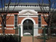
115-145 Egan St Kalgoorlie
Cnr Cassidy St
includes School of Mines and Mines
Museum
Kalgoorlie-Boulder
Goldfields
Constructed from 1895 to 1903
| Type | Status | Date | Documents |
|---|---|---|---|
| State Register | Registered | 20 Sep 1993 | HCWebsite.Listing+ListingDocument |
| Type | Status | Date | Documents |
|---|---|---|---|
| (no listings) |
| Type | Status | Date | Grading/Management | |
|---|---|---|---|---|
| Category | ||||
| Municipal Inventory | Adopted | 09 Jul 2001 | Category 1 | |
| Register of the National Estate | Permanent | 21 Mar 1978 | ||
| Classified by the National Trust | Classified | 08 Mar 1976 | ||
This building was formerly laboratory and offices çof the London and Hamburg Co. The Chamber of çMines is an unostentatious single-storey çbuilding. It has a red brick wall with stuccoed çparapet and corrugated galvanised iron verandah çfacing the street. There is a small stone wall çand hedge in front of the building. The School çof Mines and the Museum are large single storey çred brick buildings, built in a simple vernacular çstyle with corrugated galvanised iron roof and çwide verandahs. The museum has a neo-classical çentrance portico with arched gateway and çornamental pediment (N. Trust).
| Name | Type | Year From | Year To |
|---|---|---|---|
| Clarke, Arthur Edward | Architect | - | - |
| Library Id | Title | Medium | Year Of Publication |
|---|---|---|---|
| 4012 | Conservation and Museum Development Plan for Western Australian School of Mines Museum Kalgoorlie | Heritage Study {Cons'n Plan} | 1999 |
Individual Building or Group
| Epoch | General | Specific |
|---|---|---|
| Original Use | SCIENTIFIC | Laboratory or Research Station |
| Present Use | EDUCATIONAL | Museum |
| Other Use | EDUCATIONAL | Technical School |
| Original Use | COMMERCIAL | Office or Administration Bldg |
| Style |
|---|
| Federation Free Classical |
| Type | General | Specific |
|---|---|---|
| Roof | METAL | Corrugated Iron |
| Wall | BRICK | Common Brick |
| General | Specific |
|---|---|
| OCCUPATIONS | Commercial & service industries |
This information is provided voluntarily as a public service. The information provided is made available in good faith and is derived from sources believed to be reliable and accurate. However, the information is provided solely on the basis that readers will be responsible for making their own assessment of the matters discussed herein and are advised to verify all relevant representations, statements and information.
The Heritage Council of WA does not have a current assessment of the physical evidence of the buildings on site. It is known that some internal alterations have taken place, including the replacement of ceilings and light fittings. The degree to which these alterations have impinged on the heritage of the place is yet to be assessed, but there is no indication of major disruptive work.
At a meeting in September 1896, the Kalgoorlie Chamber of Mines set forth the aims and objectives of the organisation. The Chamber was established primarily to consider all questions connected with mining and to promote discussion on the subject. Members also wanted to share information and educate people about the role and importance of mining and mining matters. The Chamber of Mines Building is first mentioned in Western Argus on 25 August, 1898, when it was announced that Mr Harvey G. Draper's design for the building was accepted, and that he had been awarded the premium offered by the Chamber of ten guineas. It was also noted that Mr Draper would supervise the work (Western Argus, 25 August 1898: 20). A report on the progress of the building appeared in March 1899: "It is expected that the Chamber of Mines will in eight weeks times be in occupation of the new two storey building in Egan-street. The structure is to be of brick, with stone base, and what is being built now is designed to form part of a fairly extensive structure which the Chamber hopes to possess in the near future. For the time being, the body will be content with a one storey erection, measuring externally 50ft x 25ft. This will be divided to meet immediate needs, into a board room and two offices, with a strong room attached. The new building will furnish accommodation for a mineralogical collection of which the specimens now being gathered by the Chamber for display at the Coolgardie Exhibition, will form the nucleus. Mr J.N. Miles is the contractor for the building. The architect being Harvey G. Draper" (Western Argus, 16 March 1899). On 4 May 1899, it was reported that, 'The new brick building erected at Egan-street for the Kalgoorlie Chamber of Mines, or rather as much of the proposed building as the Chamber can at present afford, is now completed' (Western Argus, 4 May 1899: 19). This provided the Chamber with a centrally located office that enabled them to safely store their documents. Significance: Assessment of Significance: Chamber of Mines has some aesthetic significance for its contribution to the character of Kalgoorlie, as a turn of the century gold boom town. Chamber of Mines demonstrates the very strong association of the mining industry with the history of Kalgoorlie, and the eastern goldfields. Chamber of Mines is identified by the community as being an integral part of Kalgoorlie, and the eastern goldfields. Chamber of Mines is representative of the establishment of the mining industry in Kalgoorlie and Western Australia. Statement of Significance: Chamber of Mines has cultural significance for the following reasons: - the place contributes aesthetically to the character of Kalgoorlie; - the place demonstrates the very strong association of the mining industry with the history of Kalgoorlie and the eastern goldfields; and, - the place is identified by the community as being an integral part of Kalgoorlie and the eastern goldfields.
| Ref ID No | Ref Name | Ref Source | Ref Date |
|---|---|---|---|
| Western Argus |
This information is provided voluntarily as a public service. The information provided is made available in good faith and is derived from sources believed to be reliable and accurate. However, the information is provided solely on the basis that readers will be responsible for making their own assessment of the matters discussed herein and are advised to verify all relevant representations, statements and information.