Local Government
Kwinana
Region
Metropolitan
35 Kenton Way Calista
Bradford Hostel
Kwinana
Metropolitan
Constructed from 1955
| Type | Status | Date | Documents |
|---|---|---|---|
| (no listings) |
| Type | Status | Date | Documents |
|---|---|---|---|
| (no listings) |
| Type | Status | Date | Grading/Management | |
|---|---|---|---|---|
| Category | ||||
| Municipal Inventory | Adopted | 13 May 1998 | B | |
| Local Heritage Survey | Adopted | 01 Feb 2022 | B | |
Individual Building or Group
| Epoch | General | Specific |
|---|---|---|
| Original Use | HEALTH | Hospital |
| Present Use | HEALTH | Hospital |
| General | Specific |
|---|---|
| SOCIAL & CIVIC ACTIVITIES | Community services & utilities |
This information is provided voluntarily as a public service. The information provided is made available in good faith and is derived from sources believed to be reliable and accurate. However, the information is provided solely on the basis that readers will be responsible for making their own assessment of the matters discussed herein and are advised to verify all relevant representations, statements and information.
Constructed from 1955
Aesthetic Value: The former hospital building is an attractive and substantial building located in a prominent position on Kenton Way, which is characterised by its L-shaped form, weatherboard cladding, lowpitched roofs and front verandah. The former hospital building is complementary to the mostly residential streetscape of Kenton Way. Historic Value: The place has historic value as the first hospital established in the Kwinana district, following the urgent need for medical facilities for the new residential suburbs of Medina and Calista. Social Value: The place was constructed following the efforts of the Medina Residents’ Association, and has continued to function as a valuable community service. Representativeness: The building is typical of the small domestic scale maternity hospital built in the post World War Two period for the rapidly growing population of metropolitan Perth. Level of significance: Considerable
The place comprises a substantial single-storey building with an L-shaped form, located on the bend of Kenton Way. Parking facilities are located on site to the north and east of the building whilst gardens form a softer setting to the building. The building is characterised by its low pitched gable roofs clad with corrugated roof sheeting, its timber-framed walls clad with horizontal compressed fibre weatherboard, and the timber-framed verandah running the length of the west elevation, with distinctive criss-cross balustrading. A smaller verandah is located to the rear of the building, facing onto the small courtyard created by the building form. Located just south of the former hospital building is the former nurses’ quarters. The building is typical of houses constructed in the 1950s, being timber-framed and raised on stumps, with timber battens to the subfloor area, fibro cladding to the walls, and terracotta tiles to the medium-pitched gable roof. Other characteristics include the simple timber-framed entry porch and the timber-framed casement windows. The former nurses’ quarters retains its functional connection to the adjacent former hospital building, but due to refurbishment of the former hospital the visual connection has been weakened, although a common brick pier and metal panel fence front fence suggests a connection. In 2021, the place is in good condition externally, having been refurbished since 2008 including new roof and wall cladding, and the removal of sunrooms on the front verandah.
Early in January, 1955, Dr. Roe, Superintendent of Fremantle Hospital, advised that the existing facilities at Fremantle could not meet the normal hospital needs of the 10,000 residents in Rockingham and Kwinana districts. Kwinana alone had 150 maternity cases in the preceding year and the lack of medical facilities became an issue pursued by the Medina Residents’ Association. At first it appeared that the government was negotiating purchased of the Kellogg Company’s temporary construction offices, however in May it was announced that those quarters would be unsuitable and that a ten-bed maternity hospital would be built. The Medina Maternity Hospital was officially opened on 9 December 1995 by the Minister for Health, Hon. E. Nulsen, MLA. After the hospital was declared open visitors were invited to inspect the wards and nurses quarters. The hospital consisted of four wards, one with four beds, two with two beds and two with one bed. The nurses quarters were placed in a house nearby. The hospital was initially under the care of Matron Enright and Sister Enright, and the first baby was born there only five days after the official opening, to Miss Barbara Blackman. Aerial photographs from 1955 indicate that the place was originally clad in asbestos sheeting and then reroofed in green corrugated sheets in the late 1990s. This was replaced in 2003 with a white sheeting material, and again with the current grey/green colorbond sheets in 2010. There appears to have been no major changes in the original form or extent. In 2004, the place became Breathing Space, a residential treatment facility for Communicare’s Family and Domestic Violence men’s behaviour change program.
Integrity: Moderate Authenticity: High
Good
| Ref ID No | Ref Name | Ref Source | Ref Date |
|---|---|---|---|
| L Russell; "Kwinana “Third Time Lucky”, | 1979 |
This information is provided voluntarily as a public service. The information provided is made available in good faith and is derived from sources believed to be reliable and accurate. However, the information is provided solely on the basis that readers will be responsible for making their own assessment of the matters discussed herein and are advised to verify all relevant representations, statements and information.
2 Summerton Road Calista
Kwinana Golf Course, Wellard Rd
Caretaker's Cottage
Wheatfield Cottage, Stokes Cottage
Kwinana
Metropolitan
Constructed from 1850
| Type | Status | Date | Documents |
|---|---|---|---|
| (no listings) |
| Type | Status | Date | Documents |
|---|---|---|---|
| RHP - To be assessed | Current | 19 Apr 2013 |
| Type | Status | Date | Grading/Management | |
|---|---|---|---|---|
| Category | ||||
| Classified by the National Trust | Classified | 08 Jun 1998 | ||
| Local Heritage Survey | Adopted | 01 Feb 2022 | A | |
| Municipal Inventory | Adopted | 13 May 1998 | A | |
03841 East Rockingham Heritage Precinct
Good
| Library Id | Title | Medium | Year Of Publication |
|---|---|---|---|
| 11881 | Wheatfield Cottage | Heritage Study {Cons'n Plan} | 1994 |
Individual Building or Group
| Epoch | General | Specific |
|---|---|---|
| Present Use | RESIDENTIAL | Single storey residence |
| Original Use | FARMING\PASTORAL | Homestead |
| Style |
|---|
| Victorian Georgian |
| Type | General | Specific |
|---|---|---|
| Roof | METAL | Zincalume |
| Wall | STONE | Donnybrook Sandstone |
| General | Specific |
|---|---|
| DEMOGRAPHIC SETTLEMENT & MOBILITY | Settlements |
This information is provided voluntarily as a public service. The information provided is made available in good faith and is derived from sources believed to be reliable and accurate. However, the information is provided solely on the basis that readers will be responsible for making their own assessment of the matters discussed herein and are advised to verify all relevant representations, statements and information.
Constructed from 1856
Aesthetic Value: The place has aesthetic value as a modest but attractive cottage characterised by its simple form, limestone rubble walls with contrasting brick quoining, its symmetrical arrangement of door and window openings and its timber-framed verandah across the front elevation. The remaining peppercorn and mulberry trees, along with the tankstand, represent the original rural setting of the farmhouse and combine with the cottage to create pleasing environs. Historic Value: The place is associated with a number of early settlers of the district including the Smirk, Stokes and Tasker families who all occupied the place at some time. The place is associated with the settlement development of the region for farming in the mid 19th century. The place is associated with the establishment of the Kwinina Golf Club in 1959 and the changing use of the district from farming to residential. Social Value: The place is valued by the local community as evidenced by the ongoing efforts of community volunteers to retain and restore the building. The place has social value for the members of the Kwinana Golf Club and visitors who have visited the place since 1959. Level of significance: Exceptional
Wheatfield Cottage is located within the grounds of the Kwinana Golf Course accessed via a dirt road from Wellard Road. The cottage is of limestone construction with brick quoining. The place has a symmetrical frontage with two doors each flanked by window openings. The arrangement of door and window openings is reflective of the place being construcrted in stages. A timber framed skillion verandah extends across the full extent of the facade, supported on squared timber posts. The roof is hipped with corrugated galvanised iron sheeting with three masontry chimneys. The walls of the four rooms on the western end of the building (c.1856 and c.1870) are constructed of rubble stone walling, approximately 380mm thick. The walls have been rendered externally and plastered internally. The openings on the north elevation of these rooms have timber lintels. The three eastern rooms (c.1910) are constructed of limestone with quoin bricks surrounding each external opening. There is evidence of imitation ashlar work on the north elevation of these rooms. A thin render and paint finish has been applied to all the external walls. to the rear, the cottage has a further skillion roof section with different pitches to the east and west ends. Both are constructed on limestone with an open verandah area in the middle. Internally,the cottage consists of seven rooms, an entry hall dividing two of these rooms, a verandah to the north and a back verandah which is enclosed with fibro-cement cladding (c.1965). A steel-framed tank stand with a timber platform supporting a corrugated iron tank is located to the south of the cottage, while a number of mature trees are located to the west. These include a large peppercorn tree and a pair of mulberry trees. The remainder of the site is characterised by the golf course landscaping, with gum trees interspersed between the grassed areas and greens.
In 1842, Cockburn Sound Location No. 18 was granted to Marshall MacDermott, an officer in the Eighth Infantry Regiment of the British Army who was persuaded to settle in Western Australia in 1829 by the large concessions of land offered to settlers by the government. Encompassing 160 acres, it was only one small portion of the total land granted to MacDermott. The first known occupiers of the cottage were the Smirk family, who rented the property from MacDermott between c. 1855 and c. 1881, and it is believed that during this time (c.1870) Thomas Smirk extended the small cottage from two rooms into four rooms to accommodate his large family of fourteen children. In 1867, ownership of the property was transferred to James Herbert, and in 1888 was purchased by John and Alexander Forrest as an investment property. Sir John Forrest sold the property to Charles Dixon in 1902, following the death of Alexander, and in 1905 ownership was transferred to James Stokes. James Stokes is the first confirmed owner occupier of the cottage and was responsible for building three additional rooms on the eastern end of the cottage c.1910. The Stokes family occupied the property until 1917 and during this time it operated as a dairy farm. During 1917-1920, Thomas Morris, a railway employee from South Fremantle owned the property, followed by John Thorpe between 1920-1924. In 1924, the property was transferred to Frederick Tasker, and the place continued to be used as a dairy farm, then for growing pumpkins. The Tasker family continued to occupy the property until c.1957, leaving not long after it was resumed by the Public Works Act in 1953. In 1959, the Kwinana District Club opened and some maintenance was undertaken on the cottage for use as a club house. In c.1965 restoration of the cottage was carried out by volunteers with the support of the Kwinana Shire Council. The place was used as a residence for the golf course superintendent/greenkeeper since the early 1970s. Aerial photographs of the place since the mid 20th century indicates that the form and extent of the place has not changed significantly and the original cottage can still be readily determined. The roof cladding was green corrugated iron up to c2000 when it was changed to the current galvanised sheeting.
Integrity: High Authenticity: High
Good
| Ref ID No | Ref Name | Ref Source | Ref Date |
|---|---|---|---|
| Palassis Architects; " Wheatfield Cottage Conservation Plan", | Pallasis Architects | 1994 |
| Owner | Category |
|---|---|
| Town of Kwinana | Local Gov't |
This information is provided voluntarily as a public service. The information provided is made available in good faith and is derived from sources believed to be reliable and accurate. However, the information is provided solely on the basis that readers will be responsible for making their own assessment of the matters discussed herein and are advised to verify all relevant representations, statements and information.
Wellard Rd Calista
Kwinana
Metropolitan
Constructed from 1890
| Type | Status | Date | Documents |
|---|---|---|---|
| (no listings) |
| Type | Status | Date | Documents |
|---|---|---|---|
| (no listings) |
| Type | Status | Date | Grading/Management | |
|---|---|---|---|---|
| Category | ||||
| Classified by the National Trust | Classified | 02 Aug 1971 | ||
Individual Building or Group
| Epoch | General | Specific |
|---|---|---|
| Present Use | FARMING\PASTORAL | Cottage |
| Original Use | FARMING\PASTORAL | Cottage |
This information is provided voluntarily as a public service. The information provided is made available in good faith and is derived from sources believed to be reliable and accurate. However, the information is provided solely on the basis that readers will be responsible for making their own assessment of the matters discussed herein and are advised to verify all relevant representations, statements and information.
Nr Cnr Johnson/Thomas R ds Casuarina
Kwinana
Metropolitan
| Type | Status | Date | Documents |
|---|---|---|---|
| (no listings) |
| Type | Status | Date | Documents |
|---|---|---|---|
| (no listings) |
| Type | Status | Date | Grading/Management | |
|---|---|---|---|---|
| Category | ||||
| Local Heritage Survey | Adopted | 01 Feb 2022 | C | |
| Municipal Inventory | Adopted | 13 May 1998 | B | |
Historic Site
| Epoch | General | Specific |
|---|---|---|
| Present Use | VACANT\UNUSED | Vacant\Unused |
| Original Use | Transport\Communications | Road: Other |
| Type | General | Specific |
|---|---|---|
| Other | STONE | Limestone |
| General | Specific |
|---|---|
| TRANSPORT & COMMUNICATIONS | Road transport |
This information is provided voluntarily as a public service. The information provided is made available in good faith and is derived from sources believed to be reliable and accurate. However, the information is provided solely on the basis that readers will be responsible for making their own assessment of the matters discussed herein and are advised to verify all relevant representations, statements and information.
Constructed from 1920
Aesthetic Value: The remaining sections of road within bushland have aesthetic value for their contrast to the surrounding dense and built up environment. Historic Value: The place has historic value as the remains of the original road between Armadale and Rockingham, which was formalised in the 1920s to encourage the development of Rockingham as a beach resort. Research Value: The remnant portions of the road may provide evidence of former road construction or potentially have archeological finds relating to former occupants. Representativeness: The remaining road is typical of former road construction Level of Significance: Some
Portions of the original Armadale-Rockingham Road are still extant in numerous locations, and are distinguished by the remains of limestone roadbase. A number of the sections are currently functioning as bushwalk trails or informal tracks.
A road between Armadale and Rockingham began as early as the 1850s, when a winding, sandy track beginning near Key Cottage connected the two districts, however the roadway was formalised in the 1920s, when a compacted limestone base was laid. Sam Dvoretsky, Chairman of the Rockingham Road Board at this time, consistently supported the advancement of the roads leading to Fremantle, Armadale and Serpentine, knowing that these were necessary for Rockingham to develop as a desirable beach resort. The roads were also valuable adjuncts to his properties in all these areas, which by this time included Key Cottage. The alignment of the Armadale-Rockingham Road has been used as the basis for contemporary roads and currently [2021] the boundary between Orelia and Parmelia is largely on this former road alignment along Sulphur Road.
Integrity: Moderate Authenticity: Moderate
Fair
| Ref ID No | Ref Name | Ref Source | Ref Date |
|---|---|---|---|
| N Taggart; "Rockingham Looks Back". | 1984 |
This information is provided voluntarily as a public service. The information provided is made available in good faith and is derived from sources believed to be reliable and accurate. However, the information is provided solely on the basis that readers will be responsible for making their own assessment of the matters discussed herein and are advised to verify all relevant representations, statements and information.
Near Mount Brown, Beeliar Regional Park Henderson
Site of 1829-30 Clarence settlment, not to be confused with later Clarence town which is further north near Woodman Point.
Cockburn
Metropolitan
Constructed from 1829 to 1830
| Type | Status | Date | Documents |
|---|---|---|---|
| Heritage List | Adopted | 14 Jul 2011 | |
| s.79 Permit - Archaeological Excavation | YES | 19 Apr 2023 | |
| State Register | Registered | 08 Dec 2022 | HCWebsite.Listing+ListingDocument, HCWebsite.Listing+ListingDocument |
| Type | Status | Date | Documents |
|---|---|---|---|
| (no listings) |
| Type | Status | Date | Grading/Management | |
|---|---|---|---|---|
| Category | ||||
| Municipal Inventory | Adopted | 10 Apr 2014 | Category A | |
| Classified by the National Trust | Adopted | 01 Jan 2012 | ||
| Library Id | Title | Medium | Year Of Publication |
|---|---|---|---|
| 9424 | The enigma of Clarence: Woodman Point or Mount Brown? | Journal article | 2008 |
| 9812 | The land 'flow[ing]... with milk and honey': Cultural landscape changes at Peel town, Western Australia, 1829 - 1830 | Electronic | 2010 |
Historic Site
| Epoch | General | Specific |
|---|---|---|
| Original Use | RESIDENTIAL | Other |
| Present Use | PARK\RESERVE | Park\Reserve |
| General | Specific |
|---|---|
| DEMOGRAPHIC SETTLEMENT & MOBILITY | Settlements |
| PEOPLE | Early settlers |
This information is provided voluntarily as a public service. The information provided is made available in good faith and is derived from sources believed to be reliable and accurate. However, the information is provided solely on the basis that readers will be responsible for making their own assessment of the matters discussed herein and are advised to verify all relevant representations, statements and information.
(A) Clarence Cemetery has historical significance because it was the burial ground for Thomas Peel’s unsuccessful settlement at Clarence in 1830. The fate of those buried there demonstrates how harsh conditions were in the Swan River Colony for European settles in 1830. The site may have significance as an archaeological site, because nothing remains on the ground surface to indicate where the burials were situated or how many there were. Historical importance is because of the very early establishment of the burial ground when the area was first surveyed. It is probably the first cemetery or one of the first in the colony. Social importance is that of all burial grounds for their respective communities The site has both recreational and tourist importance because of its situation on high ground overlooking the coastal scenery. The history of the site demonstrates the harsh way of life and the harsh environment in the days of early settlement. When reading of the families buried there (refer: “a Colony detailed” by Ian Berryman and “Lonely Graves of Western Australia” by Yvonne & Kevin Coate) one begins to understand the development of cultural phases of the settles in the new Swan River Colony (B) Aesthetic Value The site has little aesthetic value due to the very low relief archaeological remains and moderately dense vegetation cover. Historic Value Thomas Peel’s 1830 Site is a fossilised camp dating to 1830 that shows how Western Australia’s earliest settlers adapted to a new environment. With the possible exception of the yet unsurveyed Garden Island 1829 site, it is the best well preserved early settlement camp in Western Australia. Scientific Value Thomas Peel’s 1830 Site has high scientific value. The camp’s archaeology preserve the behaviour patterns of Western Australia’s first settlers, informing about possible maladaptation and the speed of adaptation to the unknown Western Australia physical and cultural environment. The archaeological assemblage can also show whether settlers were prepared for the rigors of settlement, and what they considered their part would be in the Swan River Colony. Social Value Thomas Peel’s 1830 Site has high social value. When occupied in 1830, the camp contained about 33% of Western Australia’s population. Many of Western Australia’s present population have links with the site and the people who lived and died there. Members of the Parker, Edwards, Spice, Tuckey, Thomas, Leeder, Heard, Devenish and Meares families contribute greatly to Western Australia to this day. Rarity Thomas Peel’s 1830 Site is exceptionally rare at regional, national and international levels. Condition Thomas Peel’s 1830 Site is in excellent condition. Authenticity Thomas Peel’s 1830 Site has a very high degree of authenticity
(A) Old Historic Plan 142 (Thomas Peel’s grant near Clarence by George Smythe 1830) shows the burial ground for Clarence. Mr Ian Elliott (Dept of Land and Administration) has plotted this site onto a more recent map, which shows the site as being off Pettit Road Naval Base. Nothing now remains on the ground surface to indicate where the Clarence Cemetery could have been. As the area mapped covers a limestone outcrop, it is difficult to imagine how the graves were dug or where they might have been situated. (B) Thomas Peel’s 1830 Site is in the Beeliar Regional Park in the suburbs of Henderson and Naval Base. The 40.5-hectare area of banksia lowland and exotic vegetation contains the structural remains and discarded items of 500 men, women and children belonging to the Peel Association under the control of Thomas Peel. The material dates to 1830. Two, 15 by 15 metre areas have been examined archaeologically at the time of writing. Designated Site 1 and Site 2, the two areas contain a large collection of material remains. Accessioning of material is yet to begin, but an abridged list of the two sites’ material remains is presented below. Site 1. Site 1’s excavations unearthed a 2 by 4 metre tent pad of local limestone cobbles mortared with lime (Figure 1). A limestone and yellow brick hearth is attached to the pad’s south west corner (Figure 2). The hearth’s brick base is in two levels separated by iron sheeting. Flat limestone at each end of the hearth’s firebox suggests that bread baking also occurred in the feature. The remains of a tent pole and three cast iron tent pegs exist on the pad’s margins, while window glass was unearthed along the pad’s eastern margin. Bottle glass, the remains of an iron ash rake and a complete saltglazed stoneware blacking bottle were found on the pad and in the hearth. Extensive excavations to the pad’s north found a large collection of material. Most of this material was very small, suggestive of artefact deposition caused by sweeping material off the pad. Site 2. Site 2 comprised three areas in a 10 by 15 metre area. Area 1 consisted of partial dry stone limestone wall foundations measuring 2 by 4.5 metres (Figure 3). Excavations exposing the foundations also unearthed a layer of limestone mason’s chips, fragments of glass and ceramics and an 1827-penny. Area 2 of Site 2 has been interpreted as a structure for sleeping and living (Figure 4). A limestone and yellow brick hearth forms most of a probable timber and canvas structure’s south wall, with copper-alloy metal and timber battens used as anchors for the no longer preserved canvas. The structure’s length is 5.5 metres, but width was indeterminable. The archaeological assemblage collected from near Site 1’s limestone pad comprises beads; buttons; brass clothing hooks and eyes; two brass weights stamped with King George III’s mark; window glass – some distorted by melting; copper rod; percussion caps; gun flints; clay smoking pipe fragments and lead shot of various diameters. The lead shot, gunflints and percussion caps were unearthed within a 1 by 1 metre area. A trench about 10 metres long and 10 metres behind the pad contained items discarded by the tent’s occupants. About 1000 artefacts were recovered, including broken black glass bottle fragments; ceramic fragments of underglaze transferware (all blue in colour); creamware and yellowware bowls; a yellowware jug, many nails; an ivory domino piece; a silver chain; a brass 1820 shilling pierced with an iron nail; fragments of pig bone; barrel hoops; clay smoking pipe fragments, and brass pins. An area 32 metres square was excavated around Site 2’s structure. The following is an incomplete list of some artefacts found: five coins (two 1827 pennies, an 1827 shilling, an 1805 Irish penny and a very worn 178? penny); 32 brass thimbles, most for children’s use; c.300 brass pins; many brass clothing hooks and eyes; many brass buttons; a pair of tailor’s scissors; two iron keys; many English flint fragments; pieces of sulphur; tin container fragments; shot; seven gunflints; many clay smoking pipe fragments and glass and ceramic fragments. The fragments of English flint and sulphur are most likely associated with fire making, while the tin container fragments are probably the remains of tinderboxes. The coins were unearthed from a 1.5 by 1 metre area. Area 3 of Site 2 was the site’s cooking area. It comprises a limestone and yellow brick oven (Figure 5) measuring 3 by 1.5 metres. The excavation of heavy deposits of ash and charcoal near the oven’s throat found many nails, fragments of copper metal and pieces of glass and ceramic (some heat affected). Two sites have been excavated to completion at the time of writing. However, above surface features like low mounds of limestone and light artefact scatters at Sites 1 and 2 are also present at five other areas, strongly suggesting that well-preserved structural remains from 1830 exist nearby. In addition, artefacts with 1820 stylistic characteristics are present in small quantities over the 40-hectare area (see Site Plan 11).
Assessment A: 1990 (Cemetery Site) Assessment B: 2008 (Peel's 1830 site) (A) The burial ground off Pettit Road is a relic of Thomas Peel’s failed settlement at Clarence. The scheme suffered from bad luck and bad management. It is believed that about thirty people are buried there, all of whom died within six months of the establishment of the Clarence settlement on 1 January 1830. Most fell victim to scurvy or dysentery. The scheme was unlucky from the start, poorly provisioned and poorly led. The Clarence townsite was abandoned by 1831. Thomas peel went on to Mandurah with some of his remaining settlers and enjoyed better success. (B) Between late 1829 and early 1830, three ships containing about 500 men, women and children arrived off Western Australia’s south west coast. As part of the Peel Association lead by Thomas Peel, the settlers found land promised them in the newly established Swan River Colony already allocated to other settlers. While Peel and colony officials made arrangements regarding the allocation of new land, Peel’s group camped in sand hills fronting Cockburn Sound. There they struggled. Some were confined by indentured servant regulations inhibiting unregulated movement, while others tried making the most of what was available. All had nowhere to go. Descriptions of the camp depict individuals and family groups camped in tents, horse’s boxes and rough timber structures. Poor water, food shortages and summer heat killed 37 people already physically stressed after a four-month voyage from England. Eventually, after new land found for settlers proved poor, the group disbanded, joining other Swan River Colony settlers at Perth, Fremantle and Guildford and the Swan Valley’s agricultural allotments. By 1832, only five people remained at the camp. The camp’s dead were buried in a rectangular area marked on an 1830 map. In 1828, Thomas Peel, cousin of the Home Secretary and later British Prime Minister Robert Peel, entered into a partnership with prominent merchant Solomon Levey to establish a large scale settlement in the proposed Swan River Colony. They planned investing a large sum in the transportation of goods, equipment, livestock and labour to the Swan River Colony in return for grants of land in proportion of one acre for every one shilling sixpence expended. A 250,000-acre grant between the Swan and Canning Rivers was asked for and approved by the Colonial Office. However, to qualify for the grant, many immigrants and considerable capital assets had to arrive in the Swan River Colony by 1 November 1829. Due to delays, the first of Peel’s three ships, the Gilmore with 166 passengers, arrived six weeks late on 15 December 1829. The colony’s Lieutenant governor, James Stirling had, however, by this time granted all of Peel’s 250,000 acres to other settlers. The limited amount of fertile land on the Swan Coastal Plain, and the steady arrival of settlers since June 1829 who wanted land, forced Stirling to enforce the forfeiting clause. Peel’s late arrival meant he and his group had no privileges in the Swan River Colony, but Stirling made concessions by allowing him to select 250,000 acres from Cockburn Sound south to an inlet (Peel Inlet) and along the banks of the rivers flowing into it (the Serpentine and Murray Rivers). With nowhere to go until the making of new land allocation arrangements, the Gilmore’s passengers camped in sand hills near Mt Brown. On 12 February 1830, the Association’s second ship, the Hooghly with 176 passengers of mostly tradesmen and their families, arrived. Shortly after (14 May 1830), the Rockingham with 152 passengers arrived and then ran aground. Descriptions of the Peel town camp conditions are few but poignant. Captain George Bayly, the Hooghly’s second officer, described soon after arriving in February 1830 that most of the Gilmore’s settlers ‘get drunk everyday and lie about in the sun, so that several have been laid up with the fever’. There were many complaints by settlers to Bayly about Peel and his Association, the lack of fresh water, but the availability of too much alcohol. Bayly also mentioned that most of the Hooghly’s recently alighted passengers had congregated in their own area of Peel town that he and other settlers called Hooghly town. Bayly also describes sections of the camp: The cottages were built in a line on each side of a broad road which had been marked out by the surveyor and their fires for cooking were made in the middle of the road. Two or three carpenters and a Ship sailmarker had built themselves comfortable residences, but none of them seemed to think they were going to stay long in the place, as they found there was not much chance of employment...[t]hen I walked up to Hooghly town…a great many women and children were ill… Bayly describes an assortment of structures at Peel town, ranging from horse and cow crates converted for human use (Thomas Peel himself occupied one), houses of unspecified material covered with tarpaulins or thatched with rushes and prefabricated timber structures brought from Britain. The Dunnage family, who arrived on the Gilmore, had a ‘very pretty cottage’, most likely the ‘house in frame’ worth £248 13 shillings fourpence recorded on Dunnage’s list of imported goods. However, most settlers lived in tents and marquees ‘made by Mr Edgington of Tooley Street [London]’. Bayly produced the only visual depiction of Peel town, showing variously sized dwellings laid out with little organization on the windward side of the limestone ridge and extending to the beach and limestone cliffs. It is unclear who did the survey Bayly mentions. Roe, in the Survey Office’s monthly report, records surveying ‘Clarence’ from 25 to 31 January, but George Smythe and Henry Sutherland all produced maps dated to that year containing information about the camp’s location and site of some of its structures. Sutherland’s concentration on the coastline meant the noting of camp items only near the beach and rocky coast (like Peel’s house and store), but Smythe’s survey proceeded further in land. His map clearly shows a wide track passing between two small hills with small dwellings flanking the track and Peel’s house at the water’s edge. He records nine dwellings of unknown building material and no tents, while the graveyard and the well near Watson’s dwelling appear a later addition. By June 1830, Peel Association members were strung along the coast at Peel town, Mangles Bay (some of the people from the Rockingham that had moved from Peel’s Scheme) and near the Murray River where a small group of men assessed land. Due to continued misfortune and accident, Thomas Peel was recuperating on HMS Sulphur moored in Gage Roads, leaving Peel town’s settlers without command or advice. People’s health by this time had deteriorated further from what Bayly described. General illnesses like ophthalmia and stomach ailments were common in the Swan River Colony at this time, but the concentration of people at the camp result in greater severity. In Peel’s absence, complaints and concerns about the camp were sent to Stirling, and the resulting investigation saw the Sulphur’s surgeon, Alexander Collie, visit the site. Collie’s report examined settlers’ health, quantity and quality of food and water and the camp’s living conditions. He found about 400 people, many suffering scurvy and dysentery. He also recorded the deaths of 29 settlers, most due to dysentery and scurvy (14 and five respectively), but fatalities also due to pneumonia, childbirth complications (that claimed mother and child) and a child having died of convulsions after drinking a large quantity of alcohol. Two stillbirths are included in the 29, but not George McKenzie’s fatal spearing by Aboriginal people. Food issued from the camp’s store was sufficient but of varying quality and unavailable for the very sick, while good water had been difficult to procure until the coming of heavy rain. Collie visited the settlers’ huts, particularly those in which death had occurred, finding them ‘with a few exceptions, tolerably water proof and well ventilated, although small’. A small hospital covered with canvas existed. Collie considered that poor food and water caused much of the sickness, but ‘irregular habits’ of some of the camp’s men contributed to their deaths. He recommended growing vegetables immediately to counter scurvy. Collie found the health of the small groups at Mangles Bay and Murray River good, with the later group growing antiscorbutic plants. By August 1830, 37 of Peel town’s members were dead. Collie’s report showed Stirling that Peel was not supplying the camp’s members adequate supplies as required by indentured contracts. Despite complaints from Peel, Stirling in August 1830 released 12 families from their indentureships, and shortly after more received permission to leave. Many moved to Fremantle, Perth, Guildford and the Swan Valley, while others remained with Peel when he moved to Peel Inlet (Mandurah). By 1832, only five people remained at Peel town.
This information is provided voluntarily as a public service. The information provided is made available in good faith and is derived from sources believed to be reliable and accurate. However, the information is provided solely on the basis that readers will be responsible for making their own assessment of the matters discussed herein and are advised to verify all relevant representations, statements and information.
Constructed from 1829, Constructed from 1830
The site of early European settlement has remained undisturbed due to its bush location. It is highly valuable as it has not been built over, when comparable sites in Perth have been. Peel Town Archaeological Sites has the potential to reveal information on the colonisation of new places, the effects on the environment by a new group, adaptation to new physical and cultural 295 | P a g e environments, and understanding the mindset of an emigrating group. Peel Town Archaeological Sites is rare as a place associated with the first phases of colonisation.
Archaeological site near Mount Brown, within Beeliar Regional Park. Claimed to feature remains of the abandoned Clarence settlement of 1829-30, now called Peel Town to avoid confusion with the later and larger Clarence Town which is further north near Woodman Point. Artefacts include four collapsed limestone structures, five artefact scatters and numerous individual artefacts. Artefacts are of ceramics, glass, metal and clay. Includes a tent pad with tent pegs and pole. Clarence was one of the earliest European settlements in Perth, it was abandoned after two years. A new settlement of the same name was established further north from 1836.
Thomas Peel proposed that a township to be known as Clarence be established at Woodman Point. Early maps show the Clarence Town site occupying the area between Cockburn Sound and Lake Coogee. Peel brought 490 settlers with him from England on the Gilmore in order to establish his new colony. Owing to a series of disasters and mistiming the settlement was abandoned within three years, leaving approximately sixty graves behind. However, there is some dispute as to where exactly Western Australia’s earliest arrivals established Clarence Town in 1829. For many years it was believed the site was at Woodman Point, about 10km south of the port city. However, Notre Dame archaeologist Dr Shane Burke claims the archaeological evidence shows Clarence was at Mt Brown, about 8km south of Woodman Point. Dr Burke has unearthed many artefacts, from bottles and coins to limestone structures believed to be part of settlers’ homes. The site also contains a gravesite with what Dr Burke claims are the remains of settlers, mostly women and children, who succumbed to the harsh and isolated conditions. However, historians Pamela Statham Drew and Ruth Marchant James disagree with Dr Burke, and state that Clarence was at Woodman Point and the area Dr Burke excavated was a small settlement made by people moving away from the initial camp in 1830.
Peel Town Archaeological Sites is rare as a place associated with the first phases of colonisation.
INTEGRITY: Site only AUTHENTICITY: Site only
Site Only
| Ref ID No | Ref Name | Ref Source | Ref Date |
|---|---|---|---|
| HCWA Database No. 17868 | State Heritage Office | ||
| Register National Estate | |||
| National Trust Australia (WA) Documentation | National Trust WA |
| Owner | Category |
|---|---|
| City of Cockburn | Local Gov't |
| Alcoa of Australia Ltd | Other Private |
| Dep't for Planning & Infrastructure | State Gov't |
| Conservation Commission of Western Australia | State Gov't |
| Town of Kwinana | Local Gov't |
| Industrial Lands Development Authority | State Gov't |
This information is provided voluntarily as a public service. The information provided is made available in good faith and is derived from sources believed to be reliable and accurate. However, the information is provided solely on the basis that readers will be responsible for making their own assessment of the matters discussed herein and are advised to verify all relevant representations, statements and information.
Hope Valley
Hope Valley (General)
Kwinana
Metropolitan
| Type | Status | Date | Documents |
|---|---|---|---|
| (no listings) |
| Type | Status | Date | Documents |
|---|---|---|---|
| RHP - Does not warrant assessment | Current | 27 Sep 2019 |
| Type | Status | Date | Grading/Management | |
|---|---|---|---|---|
| Category | ||||
| Municipal Inventory | Adopted | 13 May 1998 | C | |
| Local Heritage Survey | Adopted | 01 Feb 2022 | D | |
Historic Town or district
| Epoch | General | Specific |
|---|---|---|
| Original Use | OTHER | Other |
| Present Use | OTHER | Other |
| General | Specific |
|---|---|
| PEOPLE | Early settlers |
| DEMOGRAPHIC SETTLEMENT & MOBILITY | Settlements |
This information is provided voluntarily as a public service. The information provided is made available in good faith and is derived from sources believed to be reliable and accurate. However, the information is provided solely on the basis that readers will be responsible for making their own assessment of the matters discussed herein and are advised to verify all relevant representations, statements and information.
Constructed from 1880
Aesthetic Value: A number of the buildings have individual aesthetic value, such as Postans Cottage, the de San Miguel Home, and Mortimer House, as attractive examples of buildings constructed using local building materials and skills. The various residences constructed during the mid 20th century are modest but pleasing buildings characterised by their simple forms and use of materials, and collectively contribute to the townscape of Hope Valley. Historic Value: The variety of buildings represent the gradual development of the Hope Valley area, which began with early farming around Long Swamp, followed by residential development and more intense rural industry on small blocks in the 1960s. Level of significance: Historic Site
The built environment of the Hope Valley area generally comprises a mix of buildings dating from the late 19th century and early 20th century (1880-1915), the mid 20th century (1915- 1960) and the late 20th century (1960-). Buildings from the earliest period include Postans Cottage, the de San Miguel Home, the Original Hope Valley School site and Mortimer House. The mid 20th century built environment generally comprises single storey residences located throughout the Hope Valley townsite. These homes are typically modest, timber-framed buildings clad with weatherboards or fibro cement and tiled or iron roofs. The Hope Valley Primary School also dates from the mid 20th century (although it was relocated to the current site until the 1960s) and comprises a long timber-framed building clad with timber weatherboards and a corrugated iron gable roof. Postans Shed, located adjacent to the wetlands to the south of Long Swamp dates from around 1915 and comprises a red brick and iron structure. The main township of Hope Valley comprises modest brick and tile residences, the majority of which date from the late 20th century. Some of the residences are set back from the street, on larger lots associated with rural production. The Hope Valley Hall, located next to the school on McLaren Avenue, is constructed of cream and brown bricks. There is a simple cream brick church situated on the corner of Armstrong and McLaren Avenue, also dating from the late 20th century.
During the 1880s, the Cockburn district expanded in population, with a small community established south of the ten-mile well between 1880 and 1886. The community came to be known as Hope Valley, probably named by its first settler, George Postans. Settlers were attracted by the red sandy loam and the black peat-like clay adjacent to the shallow freshwater lake known as Long Swamp. The settlers planted vegetables on the lake’s damp fringes and, where necessary, irrigated the land by channels, which spread outwards from the water’s edge. Early settlers who joined George Postans in farming the area included; Angel de San Miguel, who married George Postans’ step-daughter, Mary, and had a farm on the northwest corner of Long Swamp; John Mortimer, who married George Postans’ eldest daughter, Emma, and then settled on 40 acres at the southern end of Long Swamp; the Armstrong family, who farmed land south of Mt Brown, as well as a large lot, Lot 7/1514, being the areas where the town of Hope Valley is now located. During the period 1953-1963, the land which was originally purchased by the Armstrong brothers, Lot 7/1514, was resumed and subdivided to open the area up for housing. Between this time and 1970, more housing was built in the area, as well as the Hope Valley Primary School and the Hope Valley Community Hall. Growth of the town during the subsequent decades meant an expansion of its extent, to create the current Hope Valley township. (Source: Palassis Architects, Hope Valley Wattleup Redevelopment Project – European Heritage Study, 2003)
Integrity: Moderate Authenticity: Moderate
Good
| Ref ID No | Ref Name | Ref Source | Ref Date |
|---|---|---|---|
| Palassis Architects; "Hope Valley Wattleup Redevelopment Project – European Heritage Study", | 2003 |
This information is provided voluntarily as a public service. The information provided is made available in good faith and is derived from sources believed to be reliable and accurate. However, the information is provided solely on the basis that readers will be responsible for making their own assessment of the matters discussed herein and are advised to verify all relevant representations, statements and information.
Cnr Abercrombie & Hope Valley Rds Hope Valley
Moine
Mortimer House
Kwinana
Metropolitan
Constructed from 1913 to 1930
| Type | Status | Date | Documents |
|---|---|---|---|
| (no listings) |
| Type | Status | Date | Documents |
|---|---|---|---|
| RHP - Assessed - Below Threshold | Current | 17 Dec 1998 |
| Type | Status | Date | Grading/Management | |
|---|---|---|---|---|
| Category | ||||
| Municipal Inventory | Adopted | 13 May 1998 | B | |
| Local Heritage Survey | Adopted | 01 Feb 2022 | D | |
Individual Building or Group
| Epoch | General | Specific |
|---|---|---|
| Original Use | RESIDENTIAL | Single storey residence |
| Present Use | VACANT\UNUSED | Vacant\Unused |
| Style |
|---|
| Victorian Georgian |
| Type | General | Specific |
|---|---|---|
| Roof | TIMBER | Shingle |
| Roof | METAL | Corrugated Iron |
| Wall | BRICK | Rendered Brick |
| Wall | STONE | Limestone |
| General | Specific |
|---|---|
| PEOPLE | Early settlers |
This information is provided voluntarily as a public service. The information provided is made available in good faith and is derived from sources believed to be reliable and accurate. However, the information is provided solely on the basis that readers will be responsible for making their own assessment of the matters discussed herein and are advised to verify all relevant representations, statements and information.
Constructed from 1913, Constructed from 1892
Historic value: The site is associated with early settlers the Mortimer family who built the former residence. Level of significance: Historic Site.
house has been demolished.
An early Hope Valley settler was John William Mortimer, whose father, James Taylor Mortimer, had arrived in 1842 as a juvenile from a British correctional facility, sent to the Swan River Colony to boost the labour force. After working on a pearling lugger at Broome, in 1880, John Mortimer married George Postans’ eldest daughter, Emma, then nineteen years of age. After their marriage, the couple lived in Fremantle, selling milk from a few cows and saving for land. In 1884, John and Emma Mortimer acquired Cockburn Sound Location 305, comprising 40 acres of land on the southern end of Long Swamp. Once settled at Hope Valley, John and Emma began the task of clearing their land for a market garden, supporting themselves and their nineteen children (two of whom died young) by cutting jarrah ‘knees’ for shipbuilders and splitting sheoak shingles. In 1886, the Mortimers purchased an additional 100 acres of land (Lot 7/1525) on the northern and eastern boundaries of his Lot 305. With such a large family, the Mortimer’s were undoubtedly concerned with the provision of education in the Hope Valley area and in 1894, John Mortimer donated two acres of Lot 305 as a site for a school. The school was built that same year by John Mortimer and George Postans and was attended by their children, as well as the de San Miguel children. In 1911, Margaret O’Connell came to Hope Valley as a teacher, and by 1913 was married to James Mortimer, the third of John and Emma’s children. Soon after James and Margarets' marriage, the Mortimer House was built for them by family members, located on land near where George Postans’ Location 241 and John Mortimer’s Lot 7/1525 shared a common boundary. A subdivision of the area in 1915 shows that the land belonged to the Colonization Assurance Corporation of England, with neither George Postans or John Mortimer holding title to the land on which Mortimer’s House was situated. The title for the land, being Lots 578 and 603 (being part of Cockburn Sound Location 16), was eventually transferred to Helene Margaret Mortimer in 1921. The house was constructed with rubble limestone and had a timber shingle roof (most likely the work of John Mortimer), with the rims of wagon wheels apparently used in the windows. The shingle roof was most likely removed during the 1940s, when ownership of the place was transferred numerous times. In 1958, Lot 578 was subdivided, the resultant parcel totalling 16 acres and encompassing the homestead building. The place had numerous owners in the subsequent decade, including Dr. Edwin Alexander Dewar, who kept trotting horses on the property, and the Diamond family, who began restoring the place in the 1990s. In 1997 the place was transferred to Alcoa. With regard to the name of the place, Mortimer’s House is also referred to as ‘Moine’. As it was a large home by local standards, and its position on a rise gave it prominence, visitors to the district often asked whose house it was. James Mortimer would reply “moine”, his pronunciation of ‘mine’.
Integrity: High Authenticity: Moderate
demolished
| Ref ID No | Ref Name | Ref Source | Ref Date |
|---|---|---|---|
| L Russell; "Kwinana “Third Time Lucky”, | 1979 | ||
| Palassis Architects: "Heritage Farm, Hope Valley, Archival Documentation", | 1998 |
This information is provided voluntarily as a public service. The information provided is made available in good faith and is derived from sources believed to be reliable and accurate. However, the information is provided solely on the basis that readers will be responsible for making their own assessment of the matters discussed herein and are advised to verify all relevant representations, statements and information.
Anketell Rd Hope Valley
Kwinana
Metropolitan
Constructed from 1920 to 1921
| Type | Status | Date | Documents |
|---|---|---|---|
| (no listings) |
| Type | Status | Date | Documents |
|---|---|---|---|
| RHP - Does not warrant assessment | Current | 27 Sep 2019 |
| Type | Status | Date | Grading/Management | |
|---|---|---|---|---|
| Category | ||||
| Municipal Inventory | Adopted | 13 May 1998 | C | |
| Local Heritage Survey | Adopted | 01 Feb 2022 | C | |
Other Built Type
| Epoch | General | Specific |
|---|---|---|
| Original Use | Transport\Communications | Road: Bridge |
| Present Use | Transport\Communications | Road: Bridge |
| General | Specific |
|---|---|
| TRANSPORT & COMMUNICATIONS | Road transport |
This information is provided voluntarily as a public service. The information provided is made available in good faith and is derived from sources believed to be reliable and accurate. However, the information is provided solely on the basis that readers will be responsible for making their own assessment of the matters discussed herein and are advised to verify all relevant representations, statements and information.
Constructed from 1921
12125 Mandogalup Townsite
Historic Value: The place is associated with the Peel Estate drainage project, which involved draining lowland swamps to open up new tracts of land for farming. Social Value: The place is a well-known crossing of the main Mandogalup drain, once characterised by its white-painted timber structure, and contributes to the community’s sense of place. Representativeness: the decision to build a drainage scheme to establish agricultural land over existing swamps demonstrates the prevailing view of the Inter War period which prioritised agricultural land over the existing wetlands. Level of significance: Some.
The place comprises a simple road bridge crossing the open drain that extends southwest from Mandogalup. Culverts on either side of the bridge have been constructed with laterite stone and concrete and incorporate sloping buttresses. Dense planting enclosed by steel railing block to the view of the culvert from the southern side of the road. On the north side, the culvert extends approximately 6 metres along the length of the drain, lining the inner banks. A concrete circular channel runs beneath the road, providing free flow for water in the drain. The drain, constructed during the Inter-War period, can be clearly seen on either side of Anketell Road, comprising narrow but deep drains characterised by their mounded earth banks.
The area east of Mandogalup was the starting point for the Peel Estate drainage project which commenced in the 1920s, whereby lowland swamps were drained to reveal more fertile soil than the surrounding dry land could provide. The drains were designed by engineer-incharge, Richard Anketell, and the main drain started east of Mandogalup, passing through Beenyup, The Spectacles, Bollard Bulrush Swam, Baldivis and Folly Pool, onto Mandurah where it discharged into the sea. The crossing at Anketell Road, known as White Bridge, was most likely first constructed in the 1920s as part of the Drainage scheme works, and was originally a timber bridge, 18 metres long and painted white, explaining its name. The earlier bridge structure was replaced by the existing stone and concrete culvert construction in the 1960s.
Integrity: High Authenticity: Low
Good
| Ref ID No | Ref Name | Ref Source | Ref Date |
|---|---|---|---|
| L Russell; "Kwinana “Third Time Lucky”, | 1979 |
| Owner | Category |
|---|---|
| Crown Land | UNKNOWN |
This information is provided voluntarily as a public service. The information provided is made available in good faith and is derived from sources believed to be reliable and accurate. However, the information is provided solely on the basis that readers will be responsible for making their own assessment of the matters discussed herein and are advised to verify all relevant representations, statements and information.
25 Armstrong Rd Hope Valley
Kwinana
Metropolitan
Constructed from 1959
| Type | Status | Date | Documents |
|---|---|---|---|
| (no listings) |
| Type | Status | Date | Documents |
|---|---|---|---|
| RHP - Does not warrant assessment | Current | 28 Jun 2002 |
| Type | Status | Date | Grading/Management | |
|---|---|---|---|---|
| Category | ||||
| (no listings) | ||||
12124 Hope Valley Area Townsite
Individual Building or Group
| Epoch | General | Specific |
|---|---|---|
| Present Use | RESIDENTIAL | Single storey residence |
| Original Use | RESIDENTIAL | Single storey residence |
This information is provided voluntarily as a public service. The information provided is made available in good faith and is derived from sources believed to be reliable and accurate. However, the information is provided solely on the basis that readers will be responsible for making their own assessment of the matters discussed herein and are advised to verify all relevant representations, statements and information.
36 Armstrong Rd Hope Valley
Kwinana
Metropolitan
Constructed from 1950
| Type | Status | Date | Documents |
|---|---|---|---|
| (no listings) |
| Type | Status | Date | Documents |
|---|---|---|---|
| RHP - Does not warrant assessment | Current | 28 Jun 2005 |
| Type | Status | Date | Grading/Management | |
|---|---|---|---|---|
| Category | ||||
| (no listings) | ||||
12124 Hope Valley Area Townsite
Individual Building or Group
| Epoch | General | Specific |
|---|---|---|
| Original Use | RESIDENTIAL | Single storey residence |
| Present Use | RESIDENTIAL | Single storey residence |
This information is provided voluntarily as a public service. The information provided is made available in good faith and is derived from sources believed to be reliable and accurate. However, the information is provided solely on the basis that readers will be responsible for making their own assessment of the matters discussed herein and are advised to verify all relevant representations, statements and information.
Clementi Rd Hope Valley
Kwinana
Metropolitan
Constructed from 1920
| Type | Status | Date | Documents |
|---|---|---|---|
| (no listings) |
| Type | Status | Date | Documents |
|---|---|---|---|
| RHP - Does not warrant assessment | Current | 27 Sep 2019 |
| Type | Status | Date | Grading/Management | |
|---|---|---|---|---|
| Category | ||||
| Local Heritage Survey | Adopted | 01 Feb 2022 | D | |
| Municipal Inventory | Adopted | 13 May 1998 | C | |
Historic Site
| Epoch | General | Specific |
|---|---|---|
| Original Use | Transport\Communications | Comms: Post or Telegraph Office |
| Present Use | OTHER | Other |
| General | Specific |
|---|---|
| TRANSPORT & COMMUNICATIONS | Mail services |
This information is provided voluntarily as a public service. The information provided is made available in good faith and is derived from sources believed to be reliable and accurate. However, the information is provided solely on the basis that readers will be responsible for making their own assessment of the matters discussed herein and are advised to verify all relevant representations, statements and information.
Constructed from 1920
12125 Mandogalup Townsite
Historic Value: The site is valued for its association with the 1920s establishment of the farming community in the region and the subsequent Peel Estate Settlement. The site is valued for its association with the provision of mail services to the community by the state and federal government. Level of significance: Historic Site
There are no visible remains of the former post office building, although it was believed to have been constructed south of Grassy Swamp, a small wetland just north of the Large Eye of the Spectacles. This area is near the intersection of Clementi Road and Anketell Road, a section of cleared crown land.
The area of Wellard and Mandogalup was previously known as Balmanup, and was considered ideal for dairy farming and became part of the larger Peel Estate scheme. This site is understood to be the location of the first Post Office in the area constructed in the early 1920s. In the mid 1920s, the post office was relocated further east where the majority of the community services were located at the junction of Anketell Road and Mandogalup Road. The name Balmanup was gazetted in 1923 for the townsite and amended to Mandogalup in 1926. Typical of many simple and temporary buildings of the period the post office is believed to have been a small weatherboard and iron building raised on stumps.
Integrity: Low Authenticit: Low
N/A
| Ref ID No | Ref Name | Ref Source | Ref Date |
|---|---|---|---|
| Town of Kwinana MHI, | 1997 |
This information is provided voluntarily as a public service. The information provided is made available in good faith and is derived from sources believed to be reliable and accurate. However, the information is provided solely on the basis that readers will be responsible for making their own assessment of the matters discussed herein and are advised to verify all relevant representations, statements and information.
41 Hendy Rd Hope Valley
Postan's Cottage Ruins
Kwinana
Metropolitan
Constructed from 1892
| Type | Status | Date | Documents |
|---|---|---|---|
| (no listings) |
| Type | Status | Date | Documents |
|---|---|---|---|
| RHP - Assessed - Below Threshold | Current | 26 Jun 2015 | |
| RHP - To be assessed | Current | 26 Jun 2015 |
| Type | Status | Date | Grading/Management | |
|---|---|---|---|---|
| Category | ||||
| Classified by the National Trust | Classified | 03 Dec 1990 | ||
| Local Heritage Survey | Adopted | 01 Feb 2022 | A | |
| Municipal Inventory | Adopted | 13 May 1998 | A | |
25460 Postans' Cottage Group
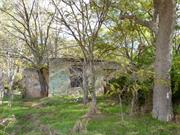
Frederick Postans’ Cottage, Hope Valley, a limestone cottage ruin and archaeological site located within a small former farming property and wetland, and built and occupied by Frederick Postans (c.1900), the son of a former convict during the early settlement of the Hope Valley area, has cultural heritage significance for the following reasons: the place has the potential to yield information contributing to a wider understanding of the European occupation of the locality and of the State, through comparison of the archaeology of the place with other archaeological and heritage sites that represent different phases of Western Australian settlement from the nineteenth to twentieth century; and the archaeology of the place is representative of archaeological deposits and surface finds associated with dwellings and farming properties from the late nineteenth and early twentieth century in Western Australia.
The place comprises the ruin of a limestone cottage surrounded by native and introduced vegetation. The east facing cottage comprises four rooms, including two with fireplaces. The kitchen contains a fireplace and a large brick oven. An addition has been added to the southern end of the cottage. No roof structure remains except in a section of the southern addition. There is considerable potential for archaeological deposits to be present across the site.
There is a high level of potential for surface and sub-surface archaeological material to be present in and around the Frederick Postans’ Cottage, Hope Valley. Archaeological material (artefacts and deposits) of this sort would be highly significant for its potential to provide information regarding the construction and occupation of Frederick Postans’ Cottage, Hope Valley. There are at least two known artefact scatters located in close proximity to Frederick Postans’ Cottage, Hope Valley. Evidence of the agricultural activities and incidental artefacts (such as nails, implements, personal items) might also be expected to be found the areas frequented by the Postans family. Areas of moderate archaeological potential include the surrounds of Hendy Road Swamp, former garden beds, including self-sown plantings, and the tracks and surrounds.
Ruin
| Library Id | Title | Medium | Year Of Publication |
|---|---|---|---|
| 6820 | Hope Valley Wattleup redevelopment project : master plan. | Report | 2003 |
Individual Building or Group
| Epoch | General | Specific |
|---|---|---|
| Present Use | VACANT\UNUSED | Vacant\Unused |
| Original Use | RESIDENTIAL | Single storey residence |
| Type | General | Specific |
|---|---|---|
| Wall | STONE | Limestone |
| General | Specific |
|---|---|
| PEOPLE | Early settlers |
| DEMOGRAPHIC SETTLEMENT & MOBILITY | Settlements |
| OCCUPATIONS | Rural industry & market gardening |
This information is provided voluntarily as a public service. The information provided is made available in good faith and is derived from sources believed to be reliable and accurate. However, the information is provided solely on the basis that readers will be responsible for making their own assessment of the matters discussed herein and are advised to verify all relevant representations, statements and information.
Constructed from 1882
Aesthetic Value: The place has aesthetic value as a picturesque ruin of a limestone cottage dating from the 1880s and the remnants are representative of a simple, limestone rural cottage of modest proportions, built using local materials. Historic Value: The place is associated with George and Harriet Postans, early settlers who established Hope Valley as an area for market gardening, and who are believed to have named the area. The place reflects the expansion of settlement in the Hope Valley area during the turn of the century. Scientific Value: The place has potential archaeological value in revealing the way of life of early settlers in an isolated rural community. Rarity The place is rare as an example of an early dwelling in the Hope Valley area. representativeness: The remnants of the structures are representative of simple, limestone rural cottages of modest proportions, built using local materials. Level of Significance: Exceptional
The site was not accessed in 2021. A description of the site in 2015 stated Frederick Postans' Cottage comprised a limestone cottage in ruinous condition, situated to the southwest of Long Swamp, on a gentle northeast slope above an un-named and mostly dry swamp. Evidence of the extent of the Postans farm remains in the form of fence posts to both the east and west of the cottage. Mature and newly seeded exotic trees, including Cape Lilacs, surround the cottage and are growing within its walls. The form of the four room cottage with two chimneys remains, although walls are deteriorating. Facing east, the limestone to the front façade is dressed and the window openings to this façade retain evidence of the limestone sills and arched lintels. There is an additional room with a separate entrance to the south and evidence of a former wall extending to the east. The limestone wall to the former front verandah is evident in parts. Some timber framing remains extant to door and window openings, but is largely deteriorated due to fire damage. No roof structure remains. There is a high level of potential for surface and sub-surface archaeological material to be present in and around the Frederick Postans’ Cottage, Hope Valley. Archaeological material (artefacts and deposits) of this sort would be highly significant for its potential to provide information regarding the construction and occupation of Frederick Postans’ Cottage, Hope Valley. There are at least two known artefact scatters located in close proximity to Frederick Postans’ Cottage, Hope Valley. Evidence of the agricultural activities and incidental artefacts (such as nails, implements, personal items) might also be expected to be found the areas frequented by the Postans family. Areas of moderate archaeological potential include the surrounds of Hendy Road Swamp, former garden beds, including self-sown plantings, and the tracks and surrounds.
George Postans arrived in Western Australia as a convict aboard the Scindian in 1850. Convicted of housebreaking at 16, he received his ticket-of-leave by 1851. Postans married Harriet Green, widow of Edwin, in 1854 and was granted a full pardon in 1858. Postans worked in the Murray District and Pinjarra as a labourer, small farmer, and bricklayer. In the 1850s, he jointly worked on a farm in North Dandalup of 15 acres with his friend, William Pollard. He is also recorded as having employed five ticket-of-leave men in Toodyay, which may also have been while working with William Pollard. By 1880 he and his wife had saved enough to settle their large family, by then numbering fifteen, on 100 acres of land in what was to become Hope Valley. A plan of the property in a surveyor’s field book (name of surveyor illegible) is dated August 1880. The plan, drawn to scale, shows a 100 acre block of land attributed to George Postans, with two fields, one approximately 10 acres and ‘under cultivation’ in the southern half of the allotment. The survey plan was drawn during the very early settlement of the allotment, prior to the official transfer of title of land to George Postans in 1882. There are two other small features noted on the plan, in approximately the middle of the block, which may illustrate the presence of a dwelling or other structures. In 2014, descendants of the Postans and de San Miguel families identified an extant structure located at 233 Hope Valley Road (Lot 241, P245456) as the original Postans’ homestead, built by George Postans. This structure corresponds with the general location of the Postans’ Homestead indicated in the 1880 plan. In 1900, 28 acres of the original Cockburn Sound Location 241 allotment was transferred to George and Harriet’s son Frederick.40 George Postans retained the remaining 72 acres, in addition to the extra 100 acres he acquired in 1887. Frederick Postans’ Cottage, Hope Valley is located in the south-western corner of the property located at 41 Hendy Road. In 2014, descendants of the Postans and de San Miguel families identified this structure as Frederick Postans’ cottage, built circa 1900.
Integrity: Moderate Authenticity: Moderate
Ruinous
| Ref ID No | Ref Name | Ref Source | Ref Date |
|---|---|---|---|
| Palassis Architects; "Hope Valley Wattleup Redevelopment Project, European Heritage Study". | Pallasis Architects | 2003 |
| Owner | Category |
|---|---|
| Town of Kwinana | Local Gov't |
This information is provided voluntarily as a public service. The information provided is made available in good faith and is derived from sources believed to be reliable and accurate. However, the information is provided solely on the basis that readers will be responsible for making their own assessment of the matters discussed herein and are advised to verify all relevant representations, statements and information.
233 Hope Valley Rd Hope Valley
Kwinana
Metropolitan
| Type | Status | Date | Documents |
|---|---|---|---|
| (no listings) |
| Type | Status | Date | Documents |
|---|---|---|---|
| RHP - Does not warrant assessment | Current | 22 Feb 2019 |
| Type | Status | Date | Grading/Management | |
|---|---|---|---|---|
| Category | ||||
| (no listings) | ||||
The Postans’ Cottage Group, Hope Valley, comprises a limestone cottage ruin and archaeological site located within a small former farming property and wetland, and built and occupied by Frederick Postans (c.1900), and the remains of an earlier cottage, constructed in the 1880s by his farther, George Postans, a former convict during the early settlement of the Hope Valley area. The place has the potential to yield information contributing to a wider understanding of the European occupation of the locality and of the State, through comparison of the archaeology of the place with other archaeological and heritage sites that represent different phases of Western Australian settlement from the nineteenth to twentieth century; and the archaeology of the place is representative of archaeological deposits and surface finds associated with dwellings and farming properties from the late nineteenth and early twentieth century in Western Australia.
George Postans' Cottage is the site located within a small former farming property and wetland, thought to have been built and occupied by George Postans, a former convict and his family, in approximately 1882, as part of the early settlement of the Hope Valley area. It is not currently known how much of the original cottage remains. Frederick Postans’ Cottage, Hope Valley, a limestone cottage ruin and archaeological site located within a small former farming property and wetland, and built and occupied by Frederick Postans (c.1900), the son of a former convict during the early settlement of the Hope Valley area, has cultural heritage significance for the following reasons: the place has the potential to yield information contributing to a wider understanding of the European occupation of the locality and of the State, through comparison of the archaeology of the place with other archaeological and heritage sites that represent different phases of Western Australian settlement from the nineteenth to twentieth century; and the archaeology of the place is representative of archaeological deposits and surface finds associated with dwellings and farming properties from the late nineteenth and early twentieth century in Western Australia.
George Postans arrived in Western Australia as a convict aboard the Scindian in 1850. Convicted of housebreaking at 16, he received his ticket-of-leave by 1851.15 Postans married Harriet Green, widow of Edwin, in 1854 and was granted a full pardon in 1858. Postans worked in the Murray District and Pinjarra as a labourer, small farmer, and bricklayer. In the 1850s, he jointly worked on a farm in North Dandalup of 15 acres with his friend, William Pollard. He is also recorded as having employed five ticket-of-leave men in Toodyay, which may also have been while working with William Pollard. By 1880 he and his wife had saved enough to settle their large family, by then numbering fifteen, on 100 acres of land in what was to become Hope Valley. A plan of the property in a surveyor’s field book (name of surveyor illegible) is dated August 1880. The plan, drawn to scale, shows a 100 acre block of land attributed to George Postans, with two fields, one approximately 10 acres and ‘under cultivation’ in the southern half of the allotment. The survey plan was drawn during the very early settlement of the allotment, prior to the official transfer of title of land to George Postans in 1882. There are two other small features noted on the plan, in approximately the middle of the block, which may illustrate the presence of a dwelling or other structures. In 2014, descendants of the Postans and de San Miguel families identified an extant structure located at 233 Hope Valley Road (Lot 241, P245456) as the original Postans’ homestead, built by George Postans. This structure corresponds with the general location of the Postans’ Homestead indicated in the 1880 plan. In 1900, 28 acres of the original Cockburn Sound Location 241 allotment was transferred to George and Harriet’s son Frederick.40 George Postans retained the remaining 72 acres, in addition to the extra 100 acres he acquired in 1887. Frederick Postans’ Cottage, Hope Valley is located in the south-western corner of the property located at 41 Hendy Road. In 2014, descendants of the Postans and de San Miguel families identified this structure as Frederick Postans’ cottage, built circa 1900.
There is a high level of potential for surface and sub-surface archaeological material to be present in and around the Frederick Postans’ Cottage, Hope Valley. Archaeological material (artefacts and deposits) of this sort would be highly significant for its potential to provide information regarding the construction and occupation of Frederick Postans’ Cottage, Hope Valley. There are at least two known artefact scatters located in close proximity to Frederick Postans’ Cottage, Hope Valley. Evidence of the agricultural activities and incidental artefacts (such as nails, implements, personal items) might also be expected to be found the areas frequented by the Postans family. Areas of moderate archaeological potential include the surrounds of Hendy Road Swamp, former garden beds, including self-sown plantings, and the tracks and surrounds.
Individual Building or Group
| Epoch | General | Specific |
|---|---|---|
| Original Use | FARMING\PASTORAL | Cottage |
| Type | General | Specific |
|---|---|---|
| Wall | STONE | Limestone |
| General | Specific |
|---|---|
| PEOPLE | Early settlers |
| DEMOGRAPHIC SETTLEMENT & MOBILITY | Settlements |
| OCCUPATIONS | Rural industry & market gardening |
This information is provided voluntarily as a public service. The information provided is made available in good faith and is derived from sources believed to be reliable and accurate. However, the information is provided solely on the basis that readers will be responsible for making their own assessment of the matters discussed herein and are advised to verify all relevant representations, statements and information.
Lot 339 Hope Valley Rd Hope Valley
Kwinana
Metropolitan
Constructed from 1886
| Type | Status | Date | Documents |
|---|---|---|---|
| (no listings) |
| Type | Status | Date | Documents |
|---|---|---|---|
| (no listings) |
| Type | Status | Date | Grading/Management | |
|---|---|---|---|---|
| Category | ||||
| Local Heritage Survey | Adopted | 01 Feb 2022 | A | |
| Municipal Inventory | Adopted | 13 May 1998 | A | |
| Library Id | Title | Medium | Year Of Publication |
|---|---|---|---|
| 6820 | Hope Valley Wattleup redevelopment project : master plan. | Report | 2003 |
Individual Building or Group
| Epoch | General | Specific |
|---|---|---|
| Present Use | FARMING\PASTORAL | Other |
| Original Use | RESIDENTIAL | Single storey residence |
| Present Use | RESIDENTIAL | Single storey residence |
| Original Use | FARMING\PASTORAL | Other |
| General | Specific |
|---|---|
| OCCUPATIONS | Rural industry & market gardening |
This information is provided voluntarily as a public service. The information provided is made available in good faith and is derived from sources believed to be reliable and accurate. However, the information is provided solely on the basis that readers will be responsible for making their own assessment of the matters discussed herein and are advised to verify all relevant representations, statements and information.
Constructed from 1886
Aesthetic Value: The remaining limestone structures have aesthetic value as picturesque, but extremely modest buildings constructed using local materials and methods. Historic Value: The place is associated with Angel and Mary de San Miguel, early settlers in the Hope Valley area who constructed the limestone buildings and operated market gardens from the site. The place reflects the expansion of settlement in the Hope Valley area before the turn of the century. Research value: The place has potential archaeological value in revealing the way of life of early settlers in an isolated rural community. representativeness: The remaining structure is typical of simple stone cottages built in the region in the mid 20th century. Level of significance: Exceptional
The place comprises three early limestone structures, one of which has been subsumed by the timber weatherboard residence constructed over it, and two others, both free-standing, located among the other sheds and farm structures that comprise the property. The main residence is a single-storey painted weatherboard and iron dwelling, rectangular in plan, with a low-pitched gable roof. Internally, the original limestone walls of a much earlier structure forms a central core, which has been extended on all sides to the depth of one room. There are two other small limestone structures located to the southeast of the main residence. The southernmost structure comprises a single room approximately 4m2, with random rubble walls, a door and remnant porch to the west, a chimney to the north, and a single timberframed window opening to the south. This structure appears to be the earliest on the property. The other limestone structure is a larger single-room shed, with coursed limestone walls, sections of which have been rendered, and a timber-framed skillion roof clad with corrugated iron. A rough-hewn timber tankstand is situated to the north of the limestone buildings. And there are two timber-framed iron sheds located to the east of the site. Vegetation in the immediate vicinity of the buildings includes a number of mature Cape Lilac trees, remnant fruit trees, and mature tuart trees.
Born in northern Spain in 1848, Angel de San Miguel arrived in Western Australia in 1869 as an orphan with the party of Bishop Salvado, and went to work at the monastery and farm at New Norcia. Only one week after his arrival at New Norcia, Miguel disappeared from the community and made his way south to Fremantle. It was to be some years before the monks knew of his fate. In 1880, it is thought that he moved to Hope Valley and found work with George Postans. That same year he married Mary Postans, the step-daughter of George Postans. In 1886, Miguel was issued with the title to Location 339, comprising 100 acres on the northwest corner of Long Swamp and southeast of Mt Brown. On this land he built a small dwelling for his family. Information from the 'Welcome Walls' of the WA Museum states that de San Miguel's original occupation was a stone mason therefore it is probable he built this family home. Some time later, Angel de San Miguel increased his land holdings by purchasing Lot 66/2123 of 150 acres, just a little north of his earlier purchase, Lot 339. Angel and Mary Miguel together produced a family of 14 children, one of whom died in infancy. Angel and Mary de San Miguel retired from the farm c1919 and settled in Fremantle. It is presumed other family members continued the farm although further research is required. Aerial photographs from the mid 1950s indicate that until the 1970s, the land adjacent to the cottage was still under cultivation. By the 1990s, there was no evidence of farming on this property or nearby properties. Since the 2010s, the land around the cottage has been progressively cleared. The cottage is still in evidence with the roof cladding in a poor condition.
Integrity: Moderate Authenticity: Moderate
Poor
| Ref ID No | Ref Name | Ref Source | Ref Date |
|---|---|---|---|
| L Russell; "Kwinana “Third Time Lucky”, | 1979 | ||
| Palassis Architects; "Hope Valley Wattleup Redevelopment Project – European Heritage Study", | 2003 |
This information is provided voluntarily as a public service. The information provided is made available in good faith and is derived from sources believed to be reliable and accurate. However, the information is provided solely on the basis that readers will be responsible for making their own assessment of the matters discussed herein and are advised to verify all relevant representations, statements and information.
Lot 339 Hope Valley Rd Hope Valley
Kwinana
Metropolitan
| Type | Status | Date | Documents |
|---|---|---|---|
| (no listings) |
| Type | Status | Date | Documents |
|---|---|---|---|
| (no listings) |
| Type | Status | Date | Grading/Management | |
|---|---|---|---|---|
| Category | ||||
| Municipal Inventory | Adopted | 13 May 1998 | A | |
| Local Heritage Survey | Adopted | 01 Feb 2022 | A | |
| Library Id | Title | Medium | Year Of Publication |
|---|---|---|---|
| 6820 | Hope Valley Wattleup redevelopment project : master plan. | Report | 2003 |
Landscape
| Epoch | General | Specific |
|---|---|---|
| Original Use | PARK\RESERVE | Park\Reserve |
| Present Use | PARK\RESERVE | Park\Reserve |
| General | Specific |
|---|---|
| SOCIAL & CIVIC ACTIVITIES | Sport, recreation & entertainment |
This information is provided voluntarily as a public service. The information provided is made available in good faith and is derived from sources believed to be reliable and accurate. However, the information is provided solely on the basis that readers will be responsible for making their own assessment of the matters discussed herein and are advised to verify all relevant representations, statements and information.
Aesthetic Value: The place has aesthetic value as a natural swamp, which has retained much of its surrounding bushland. Historic Value: The place formed the basis for the early settlement of the Hope Valley area, its soils and moisture attracting many early settlers including the Postans, de San Miguel and Mortimer families. Scientific Value: As part of the Beeliar Regional park, the place is a component of one of the most important systems of lakes and wetlands remaining in the Perth metropolitan area. In particular, the wetland is important as a summer feeding area for waterbirds. Representativeness: The remaining wetland is representative of the indigenous fauna and landscape prior to farming. Level of significance: Exceptional
Long Swamp is located to the north of the junction of Hope Valley Road and McLaren Avenue, Hope Valley. The associated wetlands extend to the south of Hope Valley Road in the area bounded by Hendy Road to the west and Abercrombie Road to the east. Long Swamp is part of the Beeliar Regional Park and lies within the Spearwood dune system at the southern end of the western chain of lakes. Long Swamp comprises an ephemeral wetland which covers an area of approximately 10 hectares, most of which is covered with reeds and paperbarks. It is surrounded by a dense fringe of swamp paperbark on the southern and eastern sides, and a mixed stand of swamp paperbark and paperbarks on the northern side. The central open area is inundated in winter and spring. At the margins of the open area samphire occurs, associated with swamp paperbark, and a small area of jointed twig-rush is situated in the deepest most permanently wet, part of the swamp. It is a summer feeding area for waterbirds and supports a variety of bush birds.
During the 1880s, the Cockburn District expanded in population, with a small community established south of the ten mile well between 1880 and 1886. This community came to be known as Hope Valley, probably named by its first settler, George Postans. Settlers were attracted to the red sandy loam and the black peat-like clay adjacent to the shallow freshwater lake known as Long Swamp. The indigenous name for this feature has not been found in this research The settlers planted vegetables on the lake’s damp fringes and, where necessary, irrigated the land by channels, which spread outwards from the water’s edge.
Integrity: Moderate Authenticity: Moderate
Good
| Ref ID No | Ref Name | Ref Source | Ref Date |
|---|---|---|---|
| Palassis Architects; "Hope Valley Wattleup Redevelopment Project – European Heritage Study". | 2003 |
This information is provided voluntarily as a public service. The information provided is made available in good faith and is derived from sources believed to be reliable and accurate. However, the information is provided solely on the basis that readers will be responsible for making their own assessment of the matters discussed herein and are advised to verify all relevant representations, statements and information.
Cnr Hope Valley Rd & McLaren Av Hope Valley
Kwinana
Metropolitan
Constructed from 1894
| Type | Status | Date | Documents |
|---|---|---|---|
| (no listings) |
| Type | Status | Date | Documents |
|---|---|---|---|
| (no listings) |
| Type | Status | Date | Grading/Management | |
|---|---|---|---|---|
| Category | ||||
| Municipal Inventory | Adopted | 13 May 1998 | B | |
| Local Heritage Survey | Adopted | 01 Feb 2022 | D | |
| Library Id | Title | Medium | Year Of Publication |
|---|---|---|---|
| 6820 | Hope Valley Wattleup redevelopment project : master plan. | Report | 2003 |
Historic Site
| Epoch | General | Specific |
|---|---|---|
| Present Use | EDUCATIONAL | Primary School |
| Original Use | EDUCATIONAL | Primary School |
| General | Specific |
|---|---|
| SOCIAL & CIVIC ACTIVITIES | Education & science |
This information is provided voluntarily as a public service. The information provided is made available in good faith and is derived from sources believed to be reliable and accurate. However, the information is provided solely on the basis that readers will be responsible for making their own assessment of the matters discussed herein and are advised to verify all relevant representations, statements and information.
Constructed from 1894
Historic Value: The place is associated with both the Postans and Mortimer families, early settlers in the Hope Valley area who made significant contributions, individually and collectively, to the development of the district, including the construction of the Hope Valley School. The place is associated with the establishment and development of the Hope Valley region. Social value: The place is valued by the community as the site of the original Hope Valley School, as evidenced by the placement of a commemorative plaque honouring the achievements of the early pioneers who established the school. Level of significance: Historic site .
A granite monolith is all that remains to mark the former site of the Hope Valley School. The rock is approximately 1 metre high and is set back approximately 4 metres from the roads edge, immediately adjacent to a tuart tree growing in the road reserve. The rock is clearly visible from the Hope Valley Road and is fixed with a plaque that reads ‘Hope Valley School Site – The school building was constructed about 1894 by George Postans (approximately 20 years after the Hope Valley Townsite was first settled), on land donated by John Mortimer. The first teacher employed at the school was E. Kershaw. The building was demolished by the State Energy Commission of W.A. in the 1950s’. A time capsule was placed under a memorial stone at the edge of the site by students of a later Hope Valley Primary School to mark the closure of their school in 2003.
In 1884, John and Emma Mortimer acquired Cockburn Sound Location 305, comprising 40 acres of land on the southern end of Long Swamp. Once settled at Hope Valley, John and Emma began the task of clearing their land for a market garden, supporting themselves and their nineteen children (two of whom died young) by cutting jarrah ‘knees’ for shipbuilders and splitting sheoak shingles. In 1886, the Mortimers purchased an additional 100 acres of land (Lot 7/1525) on the northern and eastern boundaries of his Lot 305. With such a large family, the Mortimer’s were undoubtedly concerned with the provision of education in the Hope Valley area and in 1894, John Mortimer donated two acres of Lot 305 as a site for a school. The school was built that same year by John Mortimer and George Postans and was attended by their children, as well as the de San Miguel children. The first teacher listed at the school was E. Kershaw, then the following year, 1895, J. Thompson was shown as teacher, although the school was listed as ‘Provisional’. In Education Department records, the school is not listed at all in the next two years, however in 1898 both Walter and Hannah Burns were listed as teachers. In the eight years from 1902, there were eight different teachers at Hope Valley School. In 1911, Margaret O’Connell came to Hope Valley as a teacher, and by 1913 was married to James Mortimer, the third of John and Emma’s children. Margaret Mortimer taught at the school continuously until 1924. The Hope Valley School continued to operate until the end of 1927, and a new Hope Valley school was opened on a different site in 1934. In the early 1950s, the land on which the original Hope Valley School was situated was resumed by the State Electricity Commission, with another parcel of land on Armstrong Road provided in exchange. The original school building on the site was demolished for the construction of an electrical sub-station. It is understood Hope Valley Primary School, which documentary sources suggest was known for a time as the Naval Base Primary School, moved to the Armstrong Road-McLaren Avenue site in the early 1960s. Timber framed classroom blocks may have been relocated to this new site as the re-use of facilities was a common practice at the time. In the early 2000s, the redevelopment of Hope Valley and Wattleup for mixed industrial and commercial uses and the relocation of residences away from the area by the State Government, contributed to declining school enrolments and the closure of the Hope Valley Primary School at the end of 2003. Some of the school buildings were relocated out to the Magenup Community Centre at Wandi and re-opened in November 2006.
Integrity: Low Authenticity: Low
Site Only
| Ref ID No | Ref Name | Ref Source | Ref Date |
|---|---|---|---|
| Palassis Architects; "Hope Valley Wattleup Redevelopment Project – European Heritage Study:. | 2003 |
This information is provided voluntarily as a public service. The information provided is made available in good faith and is derived from sources believed to be reliable and accurate. However, the information is provided solely on the basis that readers will be responsible for making their own assessment of the matters discussed herein and are advised to verify all relevant representations, statements and information.
233 Hope Valley Road Hope Valley
Kwinana
Metropolitan
Constructed from 1882
| Type | Status | Date | Documents |
|---|---|---|---|
| (no listings) |
| Type | Status | Date | Documents |
|---|---|---|---|
| RHP - To be assessed | Current | 26 Jun 2015 |
| Type | Status | Date | Grading/Management | |
|---|---|---|---|---|
| Category | ||||
| (no listings) | ||||
25460 Postans' Cottage Group
George Postans' Cottage is the site located within a small former farming property and wetland, thought to have been built and occupied by George Postans, a former convict and his family, in approximately 1882, as part of the early settlement of the Hope Valley area. It is not currently known how much of the original cottage remains.
George Postans arrived in Western Australia as a convict aboard the Scindian in 1850. Convicted of housebreaking at 16, he received his ticket-of-leave by 1851.15 Postans married Harriet Green, widow of Edwin, in 1854 and was granted a full pardon in 1858. Postans worked in the Murray District and Pinjarra as a labourer, small farmer, and bricklayer. In the 1850s, he jointly worked on a farm in North Dandalup of 15 acres with his friend, William Pollard. He is also recorded as having employed five ticket-of-leave men in Toodyay, which may also have been while working with William Pollard. By 1880 he and his wife had saved enough to settle their large family, by then numbering fifteen, on 100 acres of land in what was to become Hope Valley. A plan of the property in a surveyor’s field book (name of surveyor illegible) is dated August 1880. The plan, drawn to scale, shows a 100 acre block of land attributed to George Postans, with two fields, one approximately 10 acres and ‘under cultivation’ in the southern half of the allotment. The survey plan was drawn during the very early settlement of the allotment, prior to the official transfer of title of land to George Postans in 1882. There are two other small features noted on the plan, in approximately the middle of the block, which may illustrate the presence of a dwelling or other structures. In 2014, descendants of the Postans and de San Miguel families identified an extant structure located at 233 Hope Valley Road (Lot 241, P245456) as the original Postans’ homestead, built by George Postans. This structure corresponds with the general location of the Postans’ Homestead indicated in the 1880 plan.
ruin
Individual Building or Group
| Epoch | General | Specific |
|---|---|---|
| Original Use | RESIDENTIAL | Single storey residence |
| Present Use | VACANT\UNUSED | Vacant\Unused |
| General | Specific |
|---|---|
| DEMOGRAPHIC SETTLEMENT & MOBILITY | Settlements |
| PEOPLE | Early settlers |
| OCCUPATIONS | Rural industry & market gardening |
This information is provided voluntarily as a public service. The information provided is made available in good faith and is derived from sources believed to be reliable and accurate. However, the information is provided solely on the basis that readers will be responsible for making their own assessment of the matters discussed herein and are advised to verify all relevant representations, statements and information.
Cnr Chisham & Meares Av Kwinana
Kwinana
Metropolitan
Constructed from 1974
| Type | Status | Date | Documents |
|---|---|---|---|
| (no listings) |
| Type | Status | Date | Documents |
|---|---|---|---|
| (no listings) |
| Type | Status | Date | Grading/Management | |
|---|---|---|---|---|
| Category | ||||
| Fire & Rescue Service Heritage Inventory | Adopted | 30 Aug 1997 | ||
Individual Building or Group
| Epoch | General | Specific |
|---|---|---|
| Present Use | GOVERNMENTAL | Fire Station |
| Original Use | GOVERNMENTAL | Fire Station |
| General | Specific |
|---|---|
| SOCIAL & CIVIC ACTIVITIES | Community services & utilities |
This information is provided voluntarily as a public service. The information provided is made available in good faith and is derived from sources believed to be reliable and accurate. However, the information is provided solely on the basis that readers will be responsible for making their own assessment of the matters discussed herein and are advised to verify all relevant representations, statements and information.
Kwinana Railway Marshalling Yards Kwinana
Koojedda Signal Box, Kwinana Box 'B'
Kwinana Railway Yard Signal Cabin
Kwinana
Metropolitan
Constructed from 1959 to 1967
| Type | Status | Date | Documents |
|---|---|---|---|
| State Register | Registered | 13 Jul 2001 | HCWebsite.Listing+ListingDocument, HCWebsite.Listing+ListingDocument |
| Type | Status | Date | Documents |
|---|---|---|---|
| (no listings) |
| Type | Status | Date | Grading/Management | |
|---|---|---|---|---|
| Category | ||||
| Classified by the National Trust | Classified | 11 Jun 2001 | ||
| Statewide Railway Heritage Surve | Completed | 01 Mar 1994 | ||
| Municipal Inventory | Adopted | 13 May 1998 | A | |
| Local Heritage Survey | Adopted | 01 Feb 2022 | A | |
Individual Building or Group
| Epoch | General | Specific |
|---|---|---|
| Original Use | Transport\Communications | Rail: Other |
| Present Use | Transport\Communications | Rail: Other |
| Style |
|---|
| Other Style |
| Type | General | Specific |
|---|---|---|
| Wall | ASBESTOS | Fibrous Cement, corrugated |
| Wall | TIMBER | Other Timber |
| Other | METAL | Steel |
| Wall | ASBESTOS | Other Asbestos |
| Roof | ASBESTOS | Fibrous Cement, corrugated |
| General | Specific |
|---|---|
| TRANSPORT & COMMUNICATIONS | Rail & light rail transport |
| TRANSPORT & COMMUNICATIONS | Technology & technological change |
This information is provided voluntarily as a public service. The information provided is made available in good faith and is derived from sources believed to be reliable and accurate. However, the information is provided solely on the basis that readers will be responsible for making their own assessment of the matters discussed herein and are advised to verify all relevant representations, statements and information.
Constructed from 1959, Constructed from 1967
Aesthetic Value: The place has landmark value by virtue of its distinct form, elevated position and prominent location adjacent to Rockingham Road. Historic Value: The place is one of the few surviving signal cabins in Western representative of the multitude of signal cabins that were once common across the Western Australian Government Railways system. The place has historic links with the development of the Kwinana Industrial Area, particularly the Marshalling Yards which were instrumental in the transportation of goods in and out of Kwinana. Scientific Value: The place has scientific value as a geological site, and is believed to have been identified by the Geological Society of Australia (WA) in 1979 as one of the most significant geological sites in the metropolitan area. Representativeness: the signal box is representativeness of the methods used in the second half of the 20th century in rail transport. level of significance: Exceptional
The Kwinana Signal Box comprises an elevated signal cabin with an enclosed stairway and two floors, located within the Kwinana marshalling yards, adjacent to the Rockingham Road overpass. It is isolated from other buildings on the site, being immediately adjacent to the tracks, although two small buildings are located at its base, housing the relays and a standby power unit. The building is elevated upon steel supports, modular with braced trusses, allowing views across the rail tracks as well as over the road bridge. Most of the building is clad with asbestos sheeting, including the skillion roof, which overhangs on each side to form wide eaves that are lined with timber battens. The building has a number of small windows, some of which have louvres. At the upper level there are windows on all sides. The stairway, located on the southwest corner of the building, is semi-enclosed and of metal construction, with a painted finish. The signal cabin comprises two rooms; the lower floor, called the interlocking room, houses the mechanical and electro-mechanical equipment; the top floor is called the operating floor of the signal cabin. In 2021, the place is extant, with evidence of deteriorating building elements, vandalism and graffiti.
The Kwinana Railway Marshalling Yard was established in response to the development of industry in the area. Construction of earthworks for the yard and siding access commenced in April 1966 to ensure that the railway was ready for haulage of iron ore from Koolyanobbing to Kwinana that was due to commence in 1967. Train movements were expected to reach a level that would require a road bridge over the railway to replace the ground level Thomas Road, as well as extensive signalling in the yard itself. A small temporary signal box was installed at the Thomas Road end of the yard, but once the roadbridge was planned it was realised that visibility would be obscured. There was a clear need for a high level signal cabin containing a large lever frame to be insitu before the completion of the Rockingham Road overpass in 1967. The replacement signal box came from the recently redundant old Eastern Railway, in particular the Koojedda servicing depot, which had a relatively new signal cabin. The cabin was built there in 1959 (for a cost of £3,920) to replace the original 1936 cabin, and was constructed by Esslemont & Co. to the same design as the new Perth ‘A’ cabin adjacent to Melbourne Road in Perth. The new cabin at Koojedda had been opened in June 1959 when earlier signals were replaced by a modern three-aspect colour light signalling system. The relocation of the cabin, which was carried out in a period of less than 6 weeks due to the urgent timeframes, was most likely undertaken by WAGR itself and was in place by April 1967. Officially the signal cabin was known as Kwinana Box ‘B’ as the title ‘A’ was already given to an enclosed ground frame located at the Wellard end of the yard.
Integrity: High Authenticity: High
Good
| Ref ID No | Ref Name | Ref Source | Ref Date |
|---|---|---|---|
| Heritage Council of Western Australia,; "Assessment Documentation # 03112 Kwinana Signal Box", | State Heritage Office |
| Owner | Category |
|---|---|
| Crown Land | UNKNOWN |
This information is provided voluntarily as a public service. The information provided is made available in good faith and is derived from sources believed to be reliable and accurate. However, the information is provided solely on the basis that readers will be responsible for making their own assessment of the matters discussed herein and are advised to verify all relevant representations, statements and information.
Pace Rd Kwinana
Pace Road Memorial
Kwinana
Metropolitan
Constructed from 1957
| Type | Status | Date | Documents |
|---|---|---|---|
| (no listings) |
| Type | Status | Date | Documents |
|---|---|---|---|
| (no listings) |
| Type | Status | Date | Grading/Management | |
|---|---|---|---|---|
| Category | ||||
| Statewide War Memorial Survey | Completed | 01 May 1996 | ||
Historic site
| Epoch | General | Specific |
|---|---|---|
| Present Use | MONUMENT\CEMETERY | Monument |
| Original Use | MONUMENT\CEMETERY | Monument |
| Type | General | Specific |
|---|---|---|
| Other | STONE | Local Stone |
| Other | METAL | Other Metal |
| General | Specific |
|---|---|
| OUTSIDE INFLUENCES | World Wars & other wars |
This information is provided voluntarily as a public service. The information provided is made available in good faith and is derived from sources believed to be reliable and accurate. However, the information is provided solely on the basis that readers will be responsible for making their own assessment of the matters discussed herein and are advised to verify all relevant representations, statements and information.