Local Government
Mandurah
Region
Peel
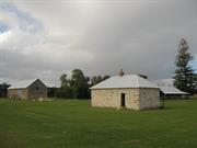
495 Estuary Rd Dawesville
Lot 102 on Plan 10569
Dawes House
Mandurah
Peel
Constructed from 1913
| Type | Status | Date | Documents |
|---|---|---|---|
| Heritage List | Adopted | 27 May 2014 | |
| State Register | Registered | 02 Sep 1997 | HCWebsite.Listing+ListingDocument, HCWebsite.Listing+ListingDocument |
| Type | Status | Date | Documents |
|---|---|---|---|
| (no listings) |
| Type | Status | Date | Grading/Management | |
|---|---|---|---|---|
| Category | ||||
| Aboriginal Heritage Sites Register | Recorded | |||
| Municipal Inventory | Adopted | 27 May 2014 | Category 1 | |
Individual Building or Group
| Epoch | General | Specific |
|---|---|---|
| Present Use | FARMING\PASTORAL | Homestead |
| Style |
|---|
| Vernacular |
| Type | General | Specific |
|---|---|---|
| Wall | STONE | Limestone |
| Roof | METAL | Corrugated Iron |
| General | Specific |
|---|---|
| DEMOGRAPHIC SETTLEMENT & MOBILITY | Settlements |
| OCCUPATIONS | Grazing, pastoralism & dairying |
This information is provided voluntarily as a public service. The information provided is made available in good faith and is derived from sources believed to be reliable and accurate. However, the information is provided solely on the basis that readers will be responsible for making their own assessment of the matters discussed herein and are advised to verify all relevant representations, statements and information.
Constructed from 1913 to 1918
• Has a landmark quality within the local environment because of its prominent location on an elevated site. • Has a close association with the development of the fishing and fish canning industries in the Mandurah region. • Associated with the Dawe family, one of the first families to settle in the area. • Contributes to the community's sense of place by demonstrating evidence of the once thriving commercial fishing industry in the region. • It is rare and has survived relatively unchanged since construction through the continuous ownership and occupation by one family for most of the twentieth century.
A single-storey stone and timber dwelling with a corrugated iron roof and an adjacent water tower and stone cellar. The property overlooks the Peel Harvey Estuary. It has six rooms, interior floors of jarrah and a front jarrah gable. A cement floor veranda surrounds the whole building. A 2.5 metre deep limestone buttery is located on the southern side of the house.
Louis Dawe was a South Australian tinsmith who came to Mandurah to become involved in the fish canning industry. He was employed in the Tuckey Brothers’ Peel Inlet Preserving Works and later settled and began canning fish at Pleasant Grove. He took over a building used as a fish cannery by the Leighton brothers, who had both tragically drowned. The cannery was a simple lean-to adjacent to the original homestead with a smokehouse constructed of wattle and daub. Dawe built a weatherboard school on the Ward’s property at Pleasant Grove in 1907 for the 15 or so children in the area. Mrs Edith Tuckey rode out there daily from Mandurah to teach the pupils. In 1913 Dawe left Pleasant Grove to build Allandale at what is now called ‘Dawesville’, approximately 10 miles south of Mandurah. The homestead was built from local limestone. Here Dawe established a second fish cannery in a factory built from weatherboard and corrugated iron, and also kept bee hives for honey. A jetty was also constructed into the estuary. The cannery was destroyed by Cyclone Alby and the jetty has been demolished. Commercial fish canning ceased at Allandale in 1930 when it became more lucrative to send the fish fresh to Perth. Louis Dawe’s son, Allan, remained at Allandale for some 70 years. The property was sold in 1996 and is currently being restored.
Authenticity : High
Good
| Ref ID No | Ref Name | Ref Source | Ref Date |
|---|---|---|---|
| Jill Burgess "Mandurah: Water Under the Bridge" | Town of Mandurah | 1988 |
| Owner | Category |
|---|---|
| CME Engineering | Other Private |
This information is provided voluntarily as a public service. The information provided is made available in good faith and is derived from sources believed to be reliable and accurate. However, the information is provided solely on the basis that readers will be responsible for making their own assessment of the matters discussed herein and are advised to verify all relevant representations, statements and information.
Apollo Pl & Picaroon Pl Halls Head
Graveyard is on Cnr Finistere Island Retreat & Picaroon Place
Mandurah
Peel
Constructed from 1860 to 1881
| Type | Status | Date | Documents |
|---|---|---|---|
| State Register | Registered | 30 May 2000 | HCWebsite.Listing+ListingDocument, HCWebsite.Listing+ListingDocument |
| Type | Status | Date | Documents |
|---|---|---|---|
| (no listings) |
| Type | Status | Date | Grading/Management | |
|---|---|---|---|---|
| Category | ||||
| (no listings) | ||||
Mandurah Historical Society advises "The farm's outbuildings including the single men's quarters, stables are basically intact but the shed has been demolished." With respect to the graveyard: "The limestone wall that surrounds the graves has fallen down and needs repairing."
| Library Id | Title | Medium | Year Of Publication |
|---|---|---|---|
| 6713 | Sutton's Farm, Apollo Place, Halls Head, Mandurah : conservation plan. | Heritage Study {Cons'n Plan} | 2004 |
| 5299 | Specification of work to be formed and materials to be used in the conservation works to Sutton Farm, Apollo Place, Mandurah. | Conservation works report | 2001 |
| 4115 | Sutton Farm Heritage Precinct, Old Coast Road Mandurah : heritage conservation report. | Heritage Study {Other} | 1995 |
| 7397 | Sutton's Farm, Apollo Place, Halls Head : specification. | Heritage Study {Other} | 2005 |
| 7197 | Sutton's farm and graveyard : Heritage Council presentation, 18 January 2005. | C D Rom | 2005 |
Individual Building or Group
| Epoch | General | Specific |
|---|---|---|
| Original Use | FARMING\PASTORAL | Homestead |
| Original Use | MONUMENT\CEMETERY | Grave |
| Present Use | VACANT\UNUSED | Vacant\Unused |
| Style |
|---|
| Victorian Georgian |
| Type | General | Specific |
|---|---|---|
| Roof | TILE | Other Tile |
| Wall | STONE | Limestone |
| General | Specific |
|---|---|
| DEMOGRAPHIC SETTLEMENT & MOBILITY | Workers {incl. Aboriginal, convict} |
| OCCUPATIONS | Grazing, pastoralism & dairying |
This information is provided voluntarily as a public service. The information provided is made available in good faith and is derived from sources believed to be reliable and accurate. However, the information is provided solely on the basis that readers will be responsible for making their own assessment of the matters discussed herein and are advised to verify all relevant representations, statements and information.
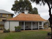
7 Leighton Rd Halls Head
Lot 173 on Plan 17616
Mandurah
Peel
Constructed from 1833
| Type | Status | Date | Documents |
|---|---|---|---|
| Heritage List | Adopted | 27 May 2014 | |
| State Register | Registered | 07 Apr 1995 | HCWebsite.Listing+ListingDocument, HCWebsite.Listing+ListingDocument |
| Type | Status | Date | Documents |
|---|---|---|---|
| (no listings) |
| Type | Status | Date | Grading/Management | |
|---|---|---|---|---|
| Category | ||||
| Register of the National Estate | Permanent | 21 Mar 1978 | ||
| Classified by the National Trust | Classified | 11 Jun 1973 | ||
| Municipal Inventory | Adopted | 27 May 2014 | Category 1 | |
| Name | Type | Year From | Year To |
|---|---|---|---|
| Hall, Henry | Architect | - | - |
| Library Id | Title | Medium | Year Of Publication |
|---|---|---|---|
| 11358 | Cast iron pillar boxes of Western Australia: An early history of the J & E Ledger foundry | Book | 2015 |
| 8781 | Hall's cottage Mandurah. | Heritage Study {Cons'n Plan} | 2007 |
| 1698 | Assessment of significance of Hall's Cottage Leighton Road Mandurah. | Report | 1992 |
Individual Building or Group
| Epoch | General | Specific |
|---|---|---|
| Present Use | EDUCATIONAL | Museum |
| Original Use | FARMING\PASTORAL | Homestead |
| Style |
|---|
| Old Colonial Georgian |
| Type | General | Specific |
|---|---|---|
| Wall | STONE | Local Stone |
| General | Specific |
|---|---|
| DEMOGRAPHIC SETTLEMENT & MOBILITY | Settlements |
This information is provided voluntarily as a public service. The information provided is made available in good faith and is derived from sources believed to be reliable and accurate. However, the information is provided solely on the basis that readers will be responsible for making their own assessment of the matters discussed herein and are advised to verify all relevant representations, statements and information.
Constructed from 1832
• A local landmark and tourist attraction. • Has a close association with a number of people who contributed to the early development of Mandurah. • Illustrates the lifestyle of the early European settlers. • Demonstrates the style of architecture that was adopted by early settlers in the Mandurah area.
Hall’s Cottage is one of the earliest homesteads in the district typifying the very earliest dwellings constructed by European settlers in the early years after the Swan River Colony was founded. Constructed of local limestone and originally roofed with hand-split sheoak shingles, the five-roomed cottage demonstrates simplicity of construction and design.
The cottage (was also known as ‘Dedallamup’) was built by Henry Hall as the home for his family, who came to Western Australia in the Protector in February 1830. Henry Hall was the Squire of Shakerstone Manor in Leicestershire and upon arrival in the Colony his extensive cargo entitled him to a land grant of some 16,594 acres south of the mouth of the Harvey River, and 200 acres on the western bank of the inlet opposite Peel Town. Unfortunately the land proved infertile, and after several years of hardship their first home and its contents were destroyed by fire. It was then, that Hall’s Cottage was built, probably with the assistance of tradesmen and servants brought out by Hall from England. Further misfortune led the family to move to Perth in 1836, and Henry Hall to return to England in 1841 to acquire capital. At this time the cottage was leased to Thomas Watson, Mandurah’s first mail contractor and an inn keeper. Later occupants included John Sutton and his family (1843), Henry Hastings Hall (Henry Edward Hall’s son - 1867-1871), and Henry Sutton, John Sutton’s son. Henry Sutton made some improvements to the building for the accommodation of travellers. After Henry Sutton’s death in 1921 the property was transferred to Joseph Cooper in 1923, and from 1925 when the Sutton family vacated Hall’s Cottage, it was rented out. On the completion of maintenance work in 1967 the Junior Farmers organisation used it as their headquarters, and in 1972 the Mandurah Historical Society moved in, opening the building to the public as a district museum in 1975.
Authenticity : High (Restored)
Good
| Name | Type | Year From | Year To |
|---|---|---|---|
| Henry Hall | Architect | - | - |
| Ref ID No | Ref Name | Ref Source | Ref Date |
|---|---|---|---|
| Mandurah Historical Society papers | |||
| File Number 5/12/053/0001 | Register of the National Database |
| Owner | Category |
|---|---|
| City of Mandurah | Local Gov't |
This information is provided voluntarily as a public service. The information provided is made available in good faith and is derived from sources believed to be reliable and accurate. However, the information is provided solely on the basis that readers will be responsible for making their own assessment of the matters discussed herein and are advised to verify all relevant representations, statements and information.
Old Coast Rd Mandurah
Lot 6
Mandurah
Peel
| Type | Status | Date | Documents |
|---|---|---|---|
| (no listings) |
| Type | Status | Date | Documents |
|---|---|---|---|
| (no listings) |
| Type | Status | Date | Grading/Management | |
|---|---|---|---|---|
| Category | ||||
| Municipal Inventory | Adopted | 15 Jul 1997 | Category 1 | |
03078 Sutton's Farm & Graveyard
Individual Building or Group
| Epoch | General | Specific |
|---|---|---|
| Present Use | VACANT\UNUSED | Vacant\Unused |
| Original Use | FARMING\PASTORAL | Homestead |
| Type | General | Specific |
|---|---|---|
| Roof | TILE | Terracotta Tile |
| Wall | STONE | Limestone |
| General | Specific |
|---|---|
| PEOPLE | Aboriginal people |
This information is provided voluntarily as a public service. The information provided is made available in good faith and is derived from sources believed to be reliable and accurate. However, the information is provided solely on the basis that readers will be responsible for making their own assessment of the matters discussed herein and are advised to verify all relevant representations, statements and information.
Constructed from 1870, Constructed from 1881
Sutton’s Farm is of high historical significance. It is associated with the Suttons and the Coopers, some of the earliest pioneering European families in the Mandurah district. Although the original homestead has been heavily modified, the farm’s outbuildings, including single men’s quarters, stables and shed, are basically intact and provide valuable insight into farming life and practices, as well as building methods and materials used in Mandurah in the 19th century. Various farm machines and implements located on the property enhance this significance. The Sutton family graveyard, which was once on the property but is now separated, is also high historical and cultural significance, providing valuable information about the fates of three of the Sutton family members. Sutton’s Farm was also the location of Winjan’s Camp, the home of a well-known Aboriginal leader in the district, George Winjan, who was also a mediator between the black and white communities. The Winjan Corporation hopes to rejuvenate Winjan’s Camp, signifying the importance of this site to Mandurah’s local Aboriginal population. A very tall Norfolk Pine adjacent to the homestead building is believed to have been planted around 1890 and is now around 20 metres high. It is one of the oldest introduced trees in the district, and has for many years been used as a beacon for both travellers and locals.
Farm comprises a modified 11-room homestead and associated farm buildings including barn/stables and single men’s quarters (1870). It was situated on prime farm land stretching from Halls Head to Falcon, 9 km south. The homestead is limestone with walls 18 inches thick and pit sawn timber. It was originally roofed with shingles and had an 8 foot verandah right around the building, but over the years the shingles have been replaced by tiles and the verandah widened and bricked in in parts. A stand of nine very old olive trees is adjacent to the homestead, and a more recent chicken coop to the rear. Old farm machinery and tools in situ. A stock race is still standing but is overgrown with grass. The graves associated with the farm are now separated by canals, but remain a feature of a small park within the Halls Head canal development. The surrounding original limestone wall is in poor condition in part, but appropriately weathered for its age, as are the trees that shelter and frame the graves. Parts of the farm can be seen from this graveyard. Winjan’s camp was also on Sutton’s Farm. This site is currently being assessed by the Australian Heritage Commission.
The homestead was built by Henry Sutton. The farm was bought by Joseph Cooper in 1924 but was still managed by the Sutton family. Tony and Hal Sutton bought back the farm in 1949 and continued to farm it until it was sold to Esplanade Developments Ltd in 1977. From the 1930s to the 1950s, football was also played on one of the farm’s paddocks when the paddock near Hackett Street became too boggy. Large trees on the farm were cleared for the purpose, however an old Norfolk Island pine tree on the property is still one of Mandurah’s arboreal landmarks. The owners of the farm have commissioned a preliminary conservation assessment, and the Heritage Council advised in January 1999 that it would be conducting a formal assessment, acting on a previous referral.
Fair
| Ref ID No | Ref Name | Ref Source | Ref Date |
|---|---|---|---|
| Ronald Richards "Mandurah and the Murray: a sequel to the history of the old Murray District of Western Australia" | Shire of Murray and City of Mandurah | 1993 |
| Owner | Category |
|---|---|
| Esplanade Pty Ltd trading as Cedar Woods Properties | Other Private |
This information is provided voluntarily as a public service. The information provided is made available in good faith and is derived from sources believed to be reliable and accurate. However, the information is provided solely on the basis that readers will be responsible for making their own assessment of the matters discussed herein and are advised to verify all relevant representations, statements and information.
1-3 Picaroon Pl Mandurah
Mandurah
Peel
| Type | Status | Date | Documents |
|---|---|---|---|
| (no listings) |
| Type | Status | Date | Documents |
|---|---|---|---|
| (no listings) |
| Type | Status | Date | Grading/Management | |
|---|---|---|---|---|
| Category | ||||
| Municipal Inventory | Adopted | 15 Jul 1999 | Category 1 | |
03078 Sutton's Farm & Graveyard
Historic Site
| Epoch | General | Specific |
|---|---|---|
| Original Use | MONUMENT\CEMETERY | Cemetery |
| Present Use | MONUMENT\CEMETERY | Cemetery |
| Type | General | Specific |
|---|---|---|
| Wall | STONE | Limestone |
| General | Specific |
|---|---|
| DEMOGRAPHIC SETTLEMENT & MOBILITY | Settlements |
This information is provided voluntarily as a public service. The information provided is made available in good faith and is derived from sources believed to be reliable and accurate. However, the information is provided solely on the basis that readers will be responsible for making their own assessment of the matters discussed herein and are advised to verify all relevant representations, statements and information.
The Sutton family graveyard, which was once on the property but is now separated, is also high historical and cultural significance, providing valuable information about the fates of three of the Sutton family members. Recommendations for Management: Preserve the graveyard and provide appropriate protection for the site.
The graves associated with the farm are now separated by canals, but remain a feature of a small park within the Halls Head canal development. The surrounding original limestone wall is in poor condition in part, but appropriately weathered for its age, as are the trees that shelter and frame the graves. Parts of the farm can be seen from this graveyard. Winjan’s camp was also on Sutton’s Farm.
Fair
| Ref ID No | Ref Name | Ref Source | Ref Date |
|---|---|---|---|
| Ronald Richards "Mandurah and the Murray: a sequel to the history of the old Murray District of Western Australia" | Shire of Mrray and city of Mandurah | 1993 |
| Owner | Category |
|---|---|
| City of Mandurah | Local Gov't |
This information is provided voluntarily as a public service. The information provided is made available in good faith and is derived from sources believed to be reliable and accurate. However, the information is provided solely on the basis that readers will be responsible for making their own assessment of the matters discussed herein and are advised to verify all relevant representations, statements and information.