Local Government
Manjimup
Region
South West
Balbarrup Rd Balbarrup
5 k from Dingup House
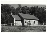
St. Thomas' Church
Manjimup
South West
Constructed from 1895 to 1898
| Type | Status | Date | Documents |
|---|---|---|---|
| Heritage List | Adopted | 08 Dec 2016 | |
| State Register | Registered | 23 Nov 2001 | HCWebsite.Listing+ListingDocument, HCWebsite.Listing+ListingDocument |
| Type | Status | Date | Documents |
|---|---|---|---|
| (no listings) |
| Type | Status | Date | Grading/Management | |
|---|---|---|---|---|
| Category | ||||
| Aboriginal Heritage Sites Register | Interim | |||
| Classified by the National Trust | Classified | 07 Sep 1987 | ||
| Register of the National Estate | Nominated | 09 Aug 1988 | ||
| Register of the National Estate | Identified Through State Process | |||
| Municipal Inventory | Adopted | 10 Jul 1997 | Category A+ | |
Sound condition with only minor vandalism damage
| Library Id | Title | Medium | Year Of Publication |
|---|---|---|---|
| 5189 | St Thomas' Church, Dingup : final report : a report on the conservation works funded under the Heritage Grants Program 1999/2000 to St Thomas' Church, Dingup. | Heritage Study {Other} | 2001 |
| 4019 | St Thomas' Church at Dingup Conservation Plan | Heritage Study {Cons'n Plan} | 1999 |
Individual Building or Group
| Epoch | General | Specific |
|---|---|---|
| Present Use | EDUCATIONAL | Combined School |
| Original Use | RELIGIOUS | Church, Cathedral or Chapel |
| Other Use | GOVERNMENTAL | Office or Administration Bldg |
| Style |
|---|
| Vernacular |
| Type | General | Specific |
|---|---|---|
| Wall | STONE | Local Stone |
| Roof | METAL | Corrugated Iron |
| General | Specific |
|---|---|
| SOCIAL & CIVIC ACTIVITIES | Religion |
| DEMOGRAPHIC SETTLEMENT & MOBILITY | Settlements |
| SOCIAL & CIVIC ACTIVITIES | Education & science |
| DEMOGRAPHIC SETTLEMENT & MOBILITY | Technology & technological change |
| OCCUPATIONS | Timber industry |
| TRANSPORT & COMMUNICATIONS | River & sea transport |
This information is provided voluntarily as a public service. The information provided is made available in good faith and is derived from sources believed to be reliable and accurate. However, the information is provided solely on the basis that readers will be responsible for making their own assessment of the matters discussed herein and are advised to verify all relevant representations, statements and information.
Constructed from 1894, Constructed from 1895
Representativeness, Rarity, Aesthetic, Social, Scientific and Historic
· Rural setting; · Prominent streetscape value; · Single storey; · Rectangular with apse added at front; · Soapstone walls with cement grouting; · High pitched corrugated iron roof; · Gothic arched windows; · Fireplace and chimney at rear of building; · Prominent timber cross on roof, and; · Timber post and rail fence surrounds church. For a more detailed description refer to: Palassis Architects, ‘St Thomas’ Church at Dingup, Conservation Plan’, prepared for Manjimup Historical Society on behalf of the Anglican Diocese of Bunbury, June 1999.
The church at Dingup was built in 1894-5 by Thomas Giblett, the eldest son of John and Ann Giblett who were the first settlers in the Manjimup district. The Giblett family had taken up land at Balbarrup in 1862. Thomas and his wife Maria lived on a property at Dingup, 4km south of the church (Refer Dingup Homestead, Central Ward). The stone for the church was quarried from the Giblett family property at Balbarrup with broad axes and saws. The blocks of stone were then transported by bullock wagons to the church site. The building was completed and licensed for use as a church by Bishop C.O.L Riley on 25 June 1895. It was extended by the addition of an apse in 1897/8. The church was also used as a schoolhouse around 1903, with the teacher living at Dingup House. The building has a fireplace and chimney probably due to its dual function as a school. It was only consecrated as St Thomas Church much later in 1923. Important conservation work was carried out on the building in recent times. This was funded by community donations, grants from the Shire of Manjimup and through the 1999/2000 heritage Grants Program of the Heritage Council of WA.
Integrity: Very Good Authenticity: Very Good
Good
| Ref ID No | Ref Name | Ref Source | Ref Date |
|---|---|---|---|
| Bennit C: "L0ocal History" | Dingup House | ||
| Palassis Architects: "St Thomas’ Church at Dingup, Conservation Plan’, prepared by Palassis Architects for the Manjimup Historical Society on behalf of the Anglican Diocese of Bunbury". | 1999 | ||
| Register of Heritage Places – Assessment Documentation, | HCWA | ||
| Heritage and Conservation Professionals: "Shire of Manjimup Municipal Heritage Inventory". | Shire of Manjimup | 1995 Adopted 1997 | |
| Berry C: "The history, landscape and heritage of the Warren district". | Manjimup Historical Society | 1987 |
| Owner | Category |
|---|---|
| Anglican Diocese | Church Property |
This information is provided voluntarily as a public service. The information provided is made available in good faith and is derived from sources believed to be reliable and accurate. However, the information is provided solely on the basis that readers will be responsible for making their own assessment of the matters discussed herein and are advised to verify all relevant representations, statements and information.
Lot 13814 Balbarrup Rd Balbarrup
Reserve 864
Manjimup
South West
| Type | Status | Date | Documents |
|---|---|---|---|
| Heritage List | Adopted | 08 Dec 2016 |
| Type | Status | Date | Documents |
|---|---|---|---|
| RHP - Does not warrant assessment | Current | 27 Sep 2019 |
| Type | Status | Date | Grading/Management | |
|---|---|---|---|---|
| Category | ||||
| Municipal Inventory | Adopted | 10 Jul 1997 | Category B | |
11424 Two Cemeteries
Other Built Type
| Epoch | General | Specific |
|---|---|---|
| Original Use | MONUMENT\CEMETERY | Cemetery |
| Present Use | MONUMENT\CEMETERY | Cemetery |
This information is provided voluntarily as a public service. The information provided is made available in good faith and is derived from sources believed to be reliable and accurate. However, the information is provided solely on the basis that readers will be responsible for making their own assessment of the matters discussed herein and are advised to verify all relevant representations, statements and information.
Constructed from 1882
11424 Two Cemeteries
Rarity, Aesthetic, Social and Historic
· There are 19 graves recorded in this cemetery which is situated on the side of a river valley; · The cemetery has a few exotic trees but is otherwise grassed, and; · The boundaries of the cemetery are well defined by a steel fence.
This cemetery was the original cemetery in the Manjimup Shire. It holds the ancestors of the early white settlers of this district. There is a plaque noting the names and dates of interment of the 19 people buried at the cemetery. It is thought the other Balbarrup Cemetery was opened because people thought the original burial place was too close to a water course. The last burial notes were in 1926. Refer to 16.4 for more historical notes
Integrity: Very High Authenticity: Very High
Good
| Ref ID No | Ref Name | Ref Source | Ref Date |
|---|---|---|---|
| Heritage and Conservation Professionals: "Shire of Manjimup Municipal Heritage Inventory". | Shire of Manjimup | 1995 Adopted 1997 |
| Owner | Category |
|---|---|
| Shire of Manjimup | Local Gov't |
This information is provided voluntarily as a public service. The information provided is made available in good faith and is derived from sources believed to be reliable and accurate. However, the information is provided solely on the basis that readers will be responsible for making their own assessment of the matters discussed herein and are advised to verify all relevant representations, statements and information.
Ballbarrup & Perup Rds Balbarrup
Loc near Balbarrup Post Office cairn
Manjimup
South West
| Type | Status | Date | Documents |
|---|---|---|---|
| (no listings) |
| Type | Status | Date | Documents |
|---|---|---|---|
| (no listings) |
| Type | Status | Date | Grading/Management | |
|---|---|---|---|---|
| Category | ||||
| (no listings) | ||||
Other Built Type
| Epoch | General | Specific |
|---|---|---|
| Present Use | MONUMENT\CEMETERY | Cemetery |
| Original Use | MONUMENT\CEMETERY | Cemetery |
| General | Specific |
|---|---|
| PEOPLE | Early settlers |
This information is provided voluntarily as a public service. The information provided is made available in good faith and is derived from sources believed to be reliable and accurate. However, the information is provided solely on the basis that readers will be responsible for making their own assessment of the matters discussed herein and are advised to verify all relevant representations, statements and information.
Perup Rd Balbarrup
Balbarrup Post Office Cairn
Manjimup
South West
| Type | Status | Date | Documents |
|---|---|---|---|
| (no listings) |
| Type | Status | Date | Documents |
|---|---|---|---|
| (no listings) |
| Type | Status | Date | Grading/Management | |
|---|---|---|---|---|
| Category | ||||
| Municipal Inventory | Adopted | 10 Jul 1997 | Category C | |
Historic Site
| Epoch | General | Specific |
|---|---|---|
| Present Use | Transport\Communications | Comms: Post or Telegraph Office |
| Original Use | Transport\Communications | Comms: Post or Telegraph Office |
| General | Specific |
|---|---|
| TRANSPORT & COMMUNICATIONS | Mail services |
This information is provided voluntarily as a public service. The information provided is made available in good faith and is derived from sources believed to be reliable and accurate. However, the information is provided solely on the basis that readers will be responsible for making their own assessment of the matters discussed herein and are advised to verify all relevant representations, statements and information.
Constructed from 1964
· The cairn is situated on the outside of a private property; · In the background of the cairn there is a very old tree marking the site of the first Giblett homestead; · The cairn is made from granite stone which is course faced and laid in a random pattern; · The cairn contains the old millstone from the flour mill first operated by the Giblett family; · The commemoration plaque is brass, and; · The cairn rise to a peak at the top.
The cairn on the site of the former post office is a commemoration to John and Ann Giblett who settled on this property in June 1861. It also marked the 100 years of continuous service of the Balbarrup Post Office which John Giblett started in January 1864. The post office was run by the Dawson family from 1909 to October 1963 when it was closed. The cairn is also has a historical connection as it contains the millstone from the former flour mill at Balbarrup. There is some confusion about a building at the house nearby. Next to the residence is an old building that the tenant of the property said was used as the Post Office when the old one was demolished. Heritage TODAY has found no anecdotal or written evidence to support this claim. However, an opening in the wall of the building and the size and design of the building all suggest it was used as a post office at some stage. Refer to 16.4 for more historical notes
Excellent
| Ref ID No | Ref Name | Ref Source | Ref Date |
|---|---|---|---|
| http://www.dli.wa.gov.au/corporate.nsf/web/History+of+country+to wn+names+-+m | |||
| Heritage Today edit: "Notes from National Trust Files" | National Trust of Australia WA | ||
| Heritage and Conservation Professionals: "Shire of Manjimup Municipal Heritage Inventory". | Shire of Manjimup | 1995 Adopted 1997 |
This information is provided voluntarily as a public service. The information provided is made available in good faith and is derived from sources believed to be reliable and accurate. However, the information is provided solely on the basis that readers will be responsible for making their own assessment of the matters discussed herein and are advised to verify all relevant representations, statements and information.
Lot 425 Perup Rd Balbarrup
Res 10572
Manjimup
South West
| Type | Status | Date | Documents |
|---|---|---|---|
| Heritage List | Adopted | 08 Dec 2016 |
| Type | Status | Date | Documents |
|---|---|---|---|
| (no listings) |
| Type | Status | Date | Grading/Management | |
|---|---|---|---|---|
| Category | ||||
| Municipal Inventory | Adopted | 10 Jul 1997 | Category B | |
11424 Two Cemeteries
Other Built Type
| Epoch | General | Specific |
|---|---|---|
| Original Use | MONUMENT\CEMETERY | Cemetery |
| Present Use | MONUMENT\CEMETERY | Cemetery |
This information is provided voluntarily as a public service. The information provided is made available in good faith and is derived from sources believed to be reliable and accurate. However, the information is provided solely on the basis that readers will be responsible for making their own assessment of the matters discussed herein and are advised to verify all relevant representations, statements and information.
Constructed from 1905
11424 Two Cemeteries
Representativeness, Aesthetic, Social and Historic
· This cemetery is located not far from the original pioneer cemetery, and; · It is set close to the road with a steel fence around it.
This cemetery was opened when the Pioneer Cemetery was deemed to close to a water source and had to be closed. Many of the ancestors of the original families are buried here. Though this cemetery is now also deemed closed pioneer families can still apply to be buried near family relatives. Refer to 16.4 for more historical notes
Integrity: Very High Authenticity: Very High
Fair
| Ref ID No | Ref Name | Ref Source | Ref Date |
|---|---|---|---|
| Heritage and Conservation Professionals: "Shire of Manjimup Municipal Heritage Inventory". | Shire of Manjimup | 1995 Adopted 1997 |
| Owner | Category |
|---|---|
| Shire of Manjimup | Local Gov't |
This information is provided voluntarily as a public service. The information provided is made available in good faith and is derived from sources believed to be reliable and accurate. However, the information is provided solely on the basis that readers will be responsible for making their own assessment of the matters discussed herein and are advised to verify all relevant representations, statements and information.
off Beedalup Rd Beedelup National Park
Manjimup
South West
| Type | Status | Date | Documents |
|---|---|---|---|
| (no listings) |
| Type | Status | Date | Documents |
|---|---|---|---|
| (no listings) |
| Type | Status | Date | Grading/Management | |
|---|---|---|---|---|
| Category | ||||
| Municipal Inventory | Adopted | 28 Aug 2008 | Category Natural Heritage (NH) | |
Landscape
| Epoch | General | Specific |
|---|---|---|
| Original Use | OTHER | Other |
This information is provided voluntarily as a public service. The information provided is made available in good faith and is derived from sources believed to be reliable and accurate. However, the information is provided solely on the basis that readers will be responsible for making their own assessment of the matters discussed herein and are advised to verify all relevant representations, statements and information.
Aesthetic, Rarity, Social and Representativeness
• Natural heritage site with high aesthetic value; • Located in the Beedelup National Park; • 18 km from Pemberton off the Vasse Highway; • Beedelup Falls drop a total of 106 metres; • The falls spread over a series of rocky cascades; • Particularly spectacular after the winter rains, and; • Foot bridges( including a suspension bridge and timber decking) give good access to view and photograph the falls.
The Beedelup Falls is a natural heritage site with high aesthetic value. It is located in the Beedelup National Park a 1500 ha area of dense karri forest which surrounds Beedelup Brook , featuring Beedelup Falls. Located 18 km from Pemberton off the Vasse Highway, the falls are particularly spectacular after the winter rains. The falls drop a total of 106 metres, spread over a series of rocky cascades. Some nearby foot bridges including a suspension bridge and timber decking give good access to view and photograph the falls. The Beedelup Falls are one of the many outstanding natural features to be seen along the Bibbulman Track, which is a world class walking trail extending nearly 1000km from Kalamunda to Albany. The idea for the track was first floated by Geoff Schafer in 1972. He was keen to encourage city dwellers to ‘go bush’. With support from the Forests Dept and seven years of planning and construction, the track was finally opened in 1979 as part of the WA 150th year celebrations. It was named in recognition of the pre-European inhabitants of the area, the Bibbulman people. In 1987 the track was overhauled, and the distinctive Waugal symbol was used for the track markers. The early 1990s saw the major revamping and realignment of the track, after extensive consultation and collaboration between government, business and community sectors. The upgrade also involved numerous school groups, community groups and individuals. The track was officially re-opened in 1995. The new track stretches nearly 1000k through a wide variety of jarrah, marri, karri, wandoo and tingle forests, interspersed with sections of coastal peppermint and heathlands. It traverses some of the most beautiful and wild areas of the South West, offering facilities unrivalled on any long trail in Australia. Thousands of people use the track each year, most people walking in stages of a couple of days each, while some earn the distinguished title of ‘End-to Enders’ for completing the track in one session. The Bibbulman Track is a valuable economic and natural heritage asset for the South West area, with a significant portion of it being in the Shire of Manjimup.
Integrity: Good Authenticity: Good
Good
| Ref ID No | Ref Name | Ref Source | Ref Date |
|---|---|---|---|
| Internet sites – Beedelup Falls; Bibbulman Track |
| Owner | Category |
|---|---|
| Dept of Environment and Conservation | State Gov't |
This information is provided voluntarily as a public service. The information provided is made available in good faith and is derived from sources believed to be reliable and accurate. However, the information is provided solely on the basis that readers will be responsible for making their own assessment of the matters discussed herein and are advised to verify all relevant representations, statements and information.
Broke
South of Fisherman Track, D'Entrecasteaux National Park
Manjimup
South West
Constructed from 1975
| Type | Status | Date | Documents |
|---|---|---|---|
| (no listings) |
| Type | Status | Date | Documents |
|---|---|---|---|
| RHP - To be assessed | Current | 24 Jun 2016 |
| Type | Status | Date | Grading/Management | |
|---|---|---|---|---|
| Category | ||||
| (no listings) | ||||
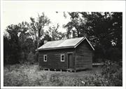
16177 Huts, D'Entrecasteaux National Park
• Mottram Hut is a good representative example of a former drover’s hut located in the southwest of the state that is associated with the early development of the pastoral industry.
• Mottram Hut is part of a collection of modest vernacular structures, constructed using simple techniques and materials which have developed as a response to the basic requirements for shelter in remote areas along the southwest coast of Western Australia.
• Mottram Hut is valued by the Mottram family who constructed the hut in 1975, on the family’s original pastoral lease, and who have continued to use and maintain the hut until the present day.
Mottram Hut is located in the area to the southeast of Broke Inlet. It is constructed of vertical sheets of corrugated iron on a bush timber structural frame and has a low pitched corrugated iron roof. There are no windows or doors, but a timber awning shutter is located on one side of the structure. The hut is open on one side in the manner typical of droving huts of the area, with a fireplace with a large, corrugated iron chimney on the open side. There is a system for collecting rainwater from the roof into a tank adjacent to the hut. There is a large water storage tank on one side. Internally the Hut is unlined with an earth floor. There is a rudimentary bathroom.
The following documentary evidence is based on the Heritage Assessment: Huts in the D’Entrecasteaux National Park, prepared for the Department of Conservation and Land Management, by Heritage and Conservation Professionals, February 2000. The D’Entrecasteaux National Park is associated with the early European use of southern coastal areas in Western Australia, for both pastoral leases and coastal recreation. Leases for cattle grazing were granted to European settlers, including the Bussells (from Vasse) and Scotts (from Nannup). Cattle were moved to coastal areas for summer grazing before returning to their inland properties. There are 62 squatters’ huts located throughout D’Entrecasteaux National Park. Some of the older huts were built by pastoralists who brought cattle to the coast for summer grazing and by the former Forests Department for staff involved in forest assessment or staffing fire lookouts. However, families or groups of friends currently use the majority of the huts on a private basis, with few available to the public. The first Mottram lease was established in 1873 at the mouth of the Meerup River. In the 1900’s a 1600ha lease was run between Mottram Lake (now known as Lake Maringup) and the beach at Coodamurrup. Another lease of 400ha was also held at Broke Inlet and 1200ha at Cliffy Head (known as Banksia Flats Station) During the early years, a hut was built closer to the mouth of the Broke Inlet for use during musters. When the South West Highway was built, cattle were driven by horses along this road to Crystal Springs and Banksia Flats Station. In later years, cattle were trucked to Crystal Springs and then driven into the station by horses. Mottram Hut was built in 1975 by the Mottram family as a drover’s hut, used for shelter during summer coastal grazing practices on the original lease. The hut was constructed to replace an existing drover’s hut located on Banksia Beach, a few kilometres away, which was not suitable due to the windy conditions. Cattle were driven from the home property located near Manjimup to Banksia Flats Station in the summer months via horseback. The cattle were grazed until mustering in June when they were returned to the farm. The Mottram’s continued to practice summer coastal grazing until 1989 when the adjoining D’Entrecasteaux National Park was extended to include the Banksia Flats Station. Following this, no animals were allowed to cross the National Park, therefore, blocking access to the coast. The Mottram family undertook a formal agreement with CALM which gave them access to and use of Mottram Hut until 2015. D’Entrecasteaux National Park was gazetted in 1978. Included within the Park boundaries were a number of different leaseholds and reserves as well as vacant crown land. The various leases and reserves implied different forms of land use, but all pastoral leases, for example, were resumed by CALM (DPAW) on creation of the Park. In 1980, legislation was introduced to provide means to remove shacks from public land for environmental reasons. In 1983, State Cabinet endorsed a position paper on coastal planning and management in Western Australia. The report set out broad policies for coastal areas and included a policy that indicated that squatter settlements were not considered acceptable. Squatter shacks that have been retained in the D’Entrecasteaux National Park were the subject of a study completed in December 2000 by Heritage and Conservation Professionals (a study which excluded Donnelly River Mouth). Management strategies for some of these huts maintain them as shelter and accommodation for park visitors, but also allow owners to use the huts, and have a locked section for their personal items. A previous management plan for D’Entrecasteaux National Park allowed lifetime leases to the hut owners near the mouth of the Donnelly River. However, lifetime leases were determined illegal and the hut owners indicated that they did not wish to be bound by the conditions of a 1987 management plan that precluded them selling or transferring ownership of the huts. In 1990, the hut owners negotiated new occupancy licences for their huts. In 2016, the owners are continuing to negotiate their role as custodians of the hut and surrounds.
Good
Individual Building or Group
| Epoch | General | Specific |
|---|---|---|
| Original Use | FARMING\PASTORAL | Other |
| Original Use | SOCIAL\RECREATIONAL | Other |
| Style |
|---|
| Vernacular |
| Type | General | Specific |
|---|---|---|
| Wall | TIMBER | Weatherboard |
| Roof | METAL | Corrugated Iron |
| General | Specific |
|---|---|
| TRANSPORT & COMMUNICATIONS | Droving |
This information is provided voluntarily as a public service. The information provided is made available in good faith and is derived from sources believed to be reliable and accurate. However, the information is provided solely on the basis that readers will be responsible for making their own assessment of the matters discussed herein and are advised to verify all relevant representations, statements and information.
Broke Inlet Rd Broke Inlet (Broke)
Manjimup
South West
| Type | Status | Date | Documents |
|---|---|---|---|
| (no listings) |
| Type | Status | Date | Documents |
|---|---|---|---|
| (no listings) |
| Type | Status | Date | Grading/Management | |
|---|---|---|---|---|
| Category | ||||
| Municipal Inventory | Adopted | 28 Aug 2008 | Category C | |
Historic site
| Epoch | General | Specific |
|---|---|---|
| Original Use | OTHER | Other |
This information is provided voluntarily as a public service. The information provided is made available in good faith and is derived from sources believed to be reliable and accurate. However, the information is provided solely on the basis that readers will be responsible for making their own assessment of the matters discussed herein and are advised to verify all relevant representations, statements and information.
Constructed from 1950
Historic, Representativeness and Aesthetic
· Coastal bushland setting; · Located close to inlet; · One of a group of simple cottages; · Small rustic cottage; · Timber frame with weatherboard cladding; · Gabled roof - corrugated iron, and; · Corrugated iron extensions.
Broke Inlet is highly valued today for its environmental and scenic attributes. There is debate about the origins of the name. It has been linked to Brockman, Broke and Brooks. An early mention of Broke Inlet was by explorer Nairn Clark who in 1841 declared that the area was fine sheep country. There is also mention made of a hut built in 1846 by three men who caught and salted fish for the Mauritius Island market. This was perhaps earliest signs of the commercial fishing activity which has continued in the inlet since the 1950s. In 1861 the explorer William Henry Graham witnessed hunting with fire by the Murrum people in the area. He and his companions joined in the wallaby hunt, successfully catching three wallabies. In the 1880s the Muirs, who were pastoralists at Deeside, had a lease on the coast between the Gardner River and Broke Inlet. They would drive the cattle down Deeside Coast Road each year for summer grazing. The cattle were left there from January to June. Refer to Muirs Hut, Coastal Ward; Bolganup Slab Hut, West Ward; and Deeside Homestead, East Ward. Broke Inlet is the location for a group of cottages and shacks, occupied by a group of commercial fisherman who have been fishing in the Inlet, some since the 1950s. One of these cottages is called ‘Judy’s Hut’. The long term future of the settlement and fishermen is currently under question. Refer to 16.5 for more historical notes
Integrity: Fair Authenticity: Fair
Fair
| Ref ID No | Ref Name | Ref Source | Ref Date |
|---|---|---|---|
| Crawford, P., and I: "Contested Country: A History of the Northcliffe Area WA". | UWA Press | 2003 |
This information is provided voluntarily as a public service. The information provided is made available in good faith and is derived from sources believed to be reliable and accurate. However, the information is provided solely on the basis that readers will be responsible for making their own assessment of the matters discussed herein and are advised to verify all relevant representations, statements and information.
Windy harbour Road Callcup
D’Entrecasteaux National Park
Manjimup
South West
| Type | Status | Date | Documents |
|---|---|---|---|
| (no listings) |
| Type | Status | Date | Documents |
|---|---|---|---|
| (no listings) |
| Type | Status | Date | Grading/Management | |
|---|---|---|---|---|
| Category | ||||
| Municipal Inventory | Adopted | 28 Aug 2008 | Category Natural Heritage (NH) | |
Landscape
This information is provided voluntarily as a public service. The information provided is made available in good faith and is derived from sources believed to be reliable and accurate. However, the information is provided solely on the basis that readers will be responsible for making their own assessment of the matters discussed herein and are advised to verify all relevant representations, statements and information.
Social and Civic
The Yeagerup Dunes are shifting dunes, about 10kms long. Apparently the ‘shifting’ dunes were noticed as early as the 1930s. Conservator T N Stoate was concerned about sand dunes moving and recommended a marram grass planting exercise. This was done in 1937 and 1938 by groups of sustenance workers, with little or no success.
Site
| Ref ID No | Ref Name | Ref Source | Ref Date |
|---|---|---|---|
| Crawford, P., and I.; "Contested Country: A History of the Northcliffe Area WA". | University of Western Australia Press | 2003 |
| Owner | Category |
|---|---|
| Dept of Environment and Conservation | State Gov't |
This information is provided voluntarily as a public service. The information provided is made available in good faith and is derived from sources believed to be reliable and accurate. However, the information is provided solely on the basis that readers will be responsible for making their own assessment of the matters discussed herein and are advised to verify all relevant representations, statements and information.
793 Stirling Rd Channybearup
9km north west of Pemberton.
Pemberton Forest Stay
Manjimup
South West
Constructed from 1939 to 1950
| Type | Status | Date | Documents |
|---|---|---|---|
| (no listings) |
| Type | Status | Date | Documents |
|---|---|---|---|
| RHP - Assessed - Below Threshold | Current | 01 Apr 2016 |
| Type | Status | Date | Grading/Management | |
|---|---|---|---|---|
| Category | ||||
| (no listings) | ||||
Fair to good.
Individual Building or Group
| Epoch | General | Specific |
|---|---|---|
| Original Use | FORESTRY | Housing or Quarters |
| Present Use | COMMERCIAL | Other |
| Type | General | Specific |
|---|---|---|
| Wall | TIMBER | Weatherboard |
| Roof | METAL | Corrugated Iron |
| General | Specific |
|---|---|
| OCCUPATIONS | Timber industry |
| DEMOGRAPHIC SETTLEMENT & MOBILITY | Settlements |
This information is provided voluntarily as a public service. The information provided is made available in good faith and is derived from sources believed to be reliable and accurate. However, the information is provided solely on the basis that readers will be responsible for making their own assessment of the matters discussed herein and are advised to verify all relevant representations, statements and information.
Collins
REGISTERED AS PART OF PEMBERTON-NORTHCLIFFE RAILWAY Sect 75 at 179.402 km Map 1 XG4; west of 150 Glauders Rd, Collins
Manjimup
South West
Constructed from 1930 to 1978
| Type | Status | Date | Documents |
|---|---|---|---|
| (no listings) |
| Type | Status | Date | Documents |
|---|---|---|---|
| (no listings) |
| Type | Status | Date | Grading/Management | |
|---|---|---|---|---|
| Category | ||||
| Statewide Lge Timber Str Survey | Completed | 11 Dec 1998 | ||
04637 Pemberton-Northcliffe Railway & Railway Station
Other Built Type
| Epoch | General | Specific |
|---|---|---|
| Present Use | Transport\Communications | Rail: Other |
| Original Use | Transport\Communications | Rail: Other |
| Type | General | Specific |
|---|---|---|
| Other | METAL | Steel |
| Other | TIMBER | Other Timber |
| General | Specific |
|---|---|
| TRANSPORT & COMMUNICATIONS | Rail & light rail transport |
This information is provided voluntarily as a public service. The information provided is made available in good faith and is derived from sources believed to be reliable and accurate. However, the information is provided solely on the basis that readers will be responsible for making their own assessment of the matters discussed herein and are advised to verify all relevant representations, statements and information.
609 Pemberton - Northcliffe Rd Collins
MI States Vasse Highway. Located near brdge over Warren River
Brockman Homestead
Manjimup
South West
Constructed from 1862
| Type | Status | Date | Documents |
|---|---|---|---|
| Heritage List | Adopted | 08 Dec 2016 |
| Type | Status | Date | Documents |
|---|---|---|---|
| RHP - To be assessed | Current | 13 Aug 2004 |
| Type | Status | Date | Grading/Management | |
|---|---|---|---|---|
| Category | ||||
| Municipal Inventory | Adopted | 10 Jul 1997 | Category B | |
| Classified by the National Trust | Classified | 23 May 1988 | ||
18746 Warren National Park
The place is a good example of a rural home in the Old Colonial Georgian architectural style.
The place has associations with the settlement of the Pemberton / Manjimup region.
The place is associated with the timber industry in the Manjimup region.
The place is a good example of a place constructed of local material and by local craftsmen in the 19th Century.
National Trust of Australia states: □ The house is built of bricks burnt at the site. □ The style of the brickwork is a mixture of Flemish and English Bond. □ It originally was roofed with Jarrah spilt shingles but now has corrugated iron. □ There are verandahs back and front. □ The joinery is the work of William Knapton.’ □ Single storey, brick and gabled tin roof □ Small panes to windows.
National Trust of Australia states: ‘Attractively situated close to the Warren River, with some of the old fruit trees from the orchard still remaining, the house was built in two sections, the first when E.R Brockman took up the land in the early 1860’s and the second about 1875, an extension to cope with his growing family. He married Capel Bussell of Cattle Chosen in 1861 and six of their nine children were born before 1875. Brockman was a leading citizen of the district, the first Chairman of the Lower Blackwood Road Board, and Warren House was an important stopping place on the road via Nannup linking the district to Busselton. The house is a good example of early homes in the area built by local workmen.’
Integrity- High Authenticity- Moderate
Sound
Individual Building or Group
| Epoch | General | Specific |
|---|---|---|
| Present Use | RESIDENTIAL | Single storey residence |
| Original Use | FORESTRY | Other |
| Original Use | RESIDENTIAL | Single storey residence |
| Original Use | RESIDENTIAL | Conjoined residence |
| Style |
|---|
| Old Colonial Georgian |
| Type | General | Specific |
|---|---|---|
| Wall | BRICK | Handmade Brick |
| Roof | METAL | Corrugated Iron |
| General | Specific |
|---|---|
| DEMOGRAPHIC SETTLEMENT & MOBILITY | Settlements |
| PEOPLE | Early settlers |
This information is provided voluntarily as a public service. The information provided is made available in good faith and is derived from sources believed to be reliable and accurate. However, the information is provided solely on the basis that readers will be responsible for making their own assessment of the matters discussed herein and are advised to verify all relevant representations, statements and information.
Constructed from 1865
Aesthetic, Historic, Rarity, Representativeness and Social
• Flat, low building set close to Warren river; • Timbered area on one side, cleared pasture land on the other; • Brick walls (bricks burnt on site); • Mixture of Flemish and English bond; • Large hipped corrugated iron roof over original shingles; • Verandah front and back under main roof; • Timber verandah posts; • Brick chimneys; • Some of the old fruit trees remain, and; • Original cattle yards constructed from post and rail fencing.
In the early 1860s Edward Revely Brockman took up land on the banks the Warren River. He married Capel Bussell in 1861 and they had nine children. This house was built for Brockman by convicts who are thought to have dug the saw pit (documented earlier) in about 1865 to provide timber for the construction of the homestead and outbuildings, which is located approx 5km north west of the sawpit. The bricks for the building were burnt on the site. The joinery is said to be the work of William Knapton. A second section of the house was built in 1875 to accommodate the growing Brockman family. The house is a good example of early homes in the area built by local workmen. Warren House was an important stopping place on the road via Nannup, linking the district to Busselton. Brockman became a leading citizen in the district, and he was the first Chairman of the Lower Blackwood Road Board. The main street in Pemberton was named after him.
Integrity: Good Authenticity: Good
Fair
| Ref ID No | Ref Name | Ref Source | Ref Date |
|---|---|---|---|
| National Trust of Australia; "Assessment Warren house". | National Trust of Australia | 1987 | |
| Heritage & Conservation Professionals; "Shire of Manjimup Municipal Heritage Inventory". | Shire of Manjimup | 1995 Adopted 1997. |
This information is provided voluntarily as a public service. The information provided is made available in good faith and is derived from sources believed to be reliable and accurate. However, the information is provided solely on the basis that readers will be responsible for making their own assessment of the matters discussed herein and are advised to verify all relevant representations, statements and information.
River Road Collins
MRWA 9395
Manjimup
South West
| Type | Status | Date | Documents |
|---|---|---|---|
| Heritage List | Adopted | 08 Dec 2016 |
| Type | Status | Date | Documents |
|---|---|---|---|
| RHP - Does not warrant assessment | Current | 11 Oct 2019 |
| Type | Status | Date | Grading/Management | |
|---|---|---|---|---|
| Category | ||||
| Municipal Inventory | Adopted | 28 Aug 2008 | Category B | |
Historic site
| Epoch | General | Specific |
|---|---|---|
| Original Use | FORESTRY | Other |
This information is provided voluntarily as a public service. The information provided is made available in good faith and is derived from sources believed to be reliable and accurate. However, the information is provided solely on the basis that readers will be responsible for making their own assessment of the matters discussed herein and are advised to verify all relevant representations, statements and information.
Aesthetic, Social and Historic
· Timber bridge, and; · Approximately 50m long.
This bridge used to be a railway bridge. There are many old railway bridges in the Shire of Manjimup that were important links in the transport of timber from the forest to the various mills situated throughout the region. River Road bridge is one of these. In 2005 the bridge is still used by hikers for on the Bibbulmun Track. The bridge is maintained for pedestrian traffic and has been adapted by the supply of a wire protective hand rail.
Integrity: Very High Authenticity: Very High
Good
This information is provided voluntarily as a public service. The information provided is made available in good faith and is derived from sources believed to be reliable and accurate. However, the information is provided solely on the basis that readers will be responsible for making their own assessment of the matters discussed herein and are advised to verify all relevant representations, statements and information.
1 Ipsen St Deanmill
Manjimup
South West
Constructed from 1914 to 1977
| Type | Status | Date | Documents |
|---|---|---|---|
| (no listings) |
| Type | Status | Date | Documents |
|---|---|---|---|
| RHP - Assessed - Below Threshold | Current | 22 Feb 2002 |
| Type | Status | Date | Grading/Management | |
|---|---|---|---|---|
| Category | ||||
| (no listings) | ||||
23451 Deanmill Townsite
It is associated with the development of the No. 1 State Saw Mill at Manjimup, later Deanmill and was constructed to a design prepared by the Public Works Department and in association
Deanmill Primary School (fmr) consists of the original, single storey timber classroom designed in the Federation Free Style with classroom and administration additions (1914, 1916 and 1956, 1961 and c.1977), timber shelter shed (1914), timber bicycle shelter shed (1945) and brick boys' & girls' toilets (1955).
with State Saw Mills as part of the development of the timber mill town.
| Name | Type | Year From | Year To |
|---|---|---|---|
| Public Works Department | Architect | - | - |
Individual Building or Group
| Epoch | General | Specific |
|---|---|---|
| Original Use | EDUCATIONAL | Primary School |
| Present Use | EDUCATIONAL | Primary School |
| Style |
|---|
| Federation Free Style |
| Type | General | Specific |
|---|---|---|
| Wall | BRICK | Common Brick |
| Wall | ASBESTOS | Fibrous Cement, weatherboard |
| Wall | TIMBER | Other Timber |
| General | Specific |
|---|---|
| SOCIAL & CIVIC ACTIVITIES | Education & science |
This information is provided voluntarily as a public service. The information provided is made available in good faith and is derived from sources believed to be reliable and accurate. However, the information is provided solely on the basis that readers will be responsible for making their own assessment of the matters discussed herein and are advised to verify all relevant representations, statements and information.
Ispen/Towie St Deanmill
Manjimup
South West
Constructed from 1913
| Type | Status | Date | Documents |
|---|---|---|---|
| Heritage List | Adopted | 08 Dec 2016 |
| Type | Status | Date | Documents |
|---|---|---|---|
| RHP - To be assessed | Current | 27 Jul 2012 |
| Type | Status | Date | Grading/Management | |
|---|---|---|---|---|
| Category | ||||
| Municipal Inventory | Adopted | 28 Aug 2008 | Category A | |
Deanmill has high aesthetic value as a historic precinct comprising a collection of relatively intact timber mill workers cottages and related buildings, including a hall and primary school. Deanmill is a substantial collection of buildings and streetscapes that collectively form a relatively intact timber town townscape. Deanmill has historic value as an integral part of State Saw Mills’ operations from 1913, and subsequently as a mill workers’ precinct under various owners until the present day (2012). Deanmill School is associated with John Todd, the youngest ever Sandover Medal winner, and later coach of the West Coast Eagles.
Deanmill is a 115-hectare mill settlement on Reserve 16355. Currently contained within the reserve area are the mill operations, a number of mill houses, the Deanmill Workers’ Club, the Deanmill Football Oval and part of the disused Deanmill Tramway. Deanmill Hall is a prominent building on corner block, with timber walls, a brick chimney and a corrugated iron gable roof. It is raised on timber stumps to allow for the sloping block. Stairs have been removed from both entrances to prevent illegal entry. Deanmill Primary School is a substantial single-storey building, in a typical Educational Department School design from the pre-WWI era. It has timber walls, brick chimneys and a corrugated iron roof. The Mill workers’ houses are of simple utilitarian design, timber and iron, with verandahs at front and rear.
Deanmill is the town that developed to hose the mill workers from State Saw Mill No.1 which was established in 1913. Deanmill was so called after Alfred Dean the first and long term manager of the mill. The mill cottages are typical of the housing supplied to workers in the early 20th century. The small scale housing and uniformity provide high streetscape value to the township. Private milling companies had been in operation long before the State Government decided to launch the State Saw Mills. Although the idea of a government timber industry had been considered in 1906, it was not until the Scaddan Government came to power that it was implemented. State Saw Mills constructed three mills in the early 1910s to cut karri sleepers for the Transcontinental Railway contract. These were named, No. 1 Mill (now Deanmill), No. 2 at Jardanup (a short distance west of No. 1, renamed ‘Jardee’ in 1924) and No. 3, 32km away at Big Brook (now Pemberton). By 1914, there were around 36 private and public mills operating throughout the state employing over 5,000 men.
Historic Town or district
| Epoch | General | Specific |
|---|---|---|
| Original Use | RESIDENTIAL | Other |
| Original Use | SOCIAL\RECREATIONAL | Trades Hall |
| Original Use | EDUCATIONAL | Primary School |
| Type | General | Specific |
|---|---|---|
| Wall | TIMBER | Weatherboard |
| General | Specific |
|---|---|
| OCCUPATIONS | Timber industry |
This information is provided voluntarily as a public service. The information provided is made available in good faith and is derived from sources believed to be reliable and accurate. However, the information is provided solely on the basis that readers will be responsible for making their own assessment of the matters discussed herein and are advised to verify all relevant representations, statements and information.
Constructed from 1912
Aesthetic, Social, Rarity, Representativeness and Historic
Deanmill Hall · Very prominent building on corner block; · Timber walls; · Raised on timber stumps to allow for sloping block; · Corrugated iron gable roof; · Brick chimney, and; · The stairs have been taken away from both entrances to prevent illegal entry. Deanmill Primary School · Substantial single storey building close to entry to the town; · Line of trees shading west side of building; · Classic Educational Department School design from pre World War I era; · Timber walls; · Brick chimneys; · Corrugated iron roof, and; · Tall timber framed windows.
Deanmill is the town that developed to hose the mill workers from State Saw Mill No.1 which was established in 1912. Deanmill was so called after Alfred Dean the first and long term manager of the mill. The mill cottages are typical of the housing supplied to workers in the early twentieth century. The small scale housing and uniformity provide high streetscape value to the township. The school with 60 pupils, opened in 1914 as a result of a petition to the Education Department by Deanmill parents. The population of students rose to 90 in the 1950s but in 1998 when the enrolments dropped as low as 12 with one teacher the parents made the decision to close the school and send their children to Manjimup. The most famous Deanmill School graduate was footballer John Todd. When the school closed the community was hoping it could be retained as a community centre (West Australian 14 December 1998) but in 2005 the school still remains unoccupied and a question about its future use is still unanswered. The Town Hall is another prominent building which though seemingly important to the community has no current function. Refer to 16.4 for more historical notes
Various
| Ref ID No | Ref Name | Ref Source | Ref Date |
|---|---|---|---|
| "Newspaper Article". | West Australian | 14 December 1998 | |
| Heritage and Conservation Professionals: "Shire of Manjimup Municipal Heritage Inventory". | Shire of Manjimup | 1995 Adopted 1997 |
This information is provided voluntarily as a public service. The information provided is made available in good faith and is derived from sources believed to be reliable and accurate. However, the information is provided solely on the basis that readers will be responsible for making their own assessment of the matters discussed herein and are advised to verify all relevant representations, statements and information.
Muirs Hwy Deeside
Hall
School
Manjimup
South West
Constructed from 1930
| Type | Status | Date | Documents |
|---|---|---|---|
| (no listings) |
| Type | Status | Date | Documents |
|---|---|---|---|
| (no listings) |
| Type | Status | Date | Grading/Management | |
|---|---|---|---|---|
| Category | ||||
| (no listings) | ||||
Individual Building or Group
| Epoch | General | Specific |
|---|---|---|
| Original Use | RELIGIOUS | Church, Cathedral or Chapel |
| Other Use | EDUCATIONAL | Combined School |
| Present Use | RELIGIOUS | Church Hall |
This information is provided voluntarily as a public service. The information provided is made available in good faith and is derived from sources believed to be reliable and accurate. However, the information is provided solely on the basis that readers will be responsible for making their own assessment of the matters discussed herein and are advised to verify all relevant representations, statements and information.
D'Entrecasteaux National Park
Manjimup
South West
Constructed from 1960
| Type | Status | Date | Documents |
|---|---|---|---|
| (no listings) |
| Type | Status | Date | Documents |
|---|---|---|---|
| RHP - Does not warrant assessment | Current | 25 Nov 2005 |
| Type | Status | Date | Grading/Management | |
|---|---|---|---|---|
| Category | ||||
| (no listings) | ||||
Individual Building or Group
| Epoch | General | Specific |
|---|---|---|
| Original Use | RESIDENTIAL | Other |
| Present Use | RESIDENTIAL | Other |
| Style |
|---|
| Vernacular |
| Type | General | Specific |
|---|---|---|
| Roof | METAL | Steel |
| Wall | METAL | Steel |
| General | Specific |
|---|---|
| SOCIAL & CIVIC ACTIVITIES | Sport, recreation & entertainment |
This information is provided voluntarily as a public service. The information provided is made available in good faith and is derived from sources believed to be reliable and accurate. However, the information is provided solely on the basis that readers will be responsible for making their own assessment of the matters discussed herein and are advised to verify all relevant representations, statements and information.
D'Entrecasteaux National Park
Coodamurrup Homestead
Moore's Hut
Manjimup
South West
Constructed from 1913
| Type | Status | Date | Documents |
|---|---|---|---|
| (no listings) |
| Type | Status | Date | Documents |
|---|---|---|---|
| RHP - To be assessed | Current | 25 Nov 2005 |
| Type | Status | Date | Grading/Management | |
|---|---|---|---|---|
| Category | ||||
| Municipal Inventory | Adopted | 10 Jul 1997 | Category C | |
16177 Huts, D'Entrecasteaux National Park
Good
Individual Building or Group
| Epoch | General | Specific |
|---|---|---|
| Present Use | RESIDENTIAL | Other |
| Original Use | RESIDENTIAL | Other |
| Style |
|---|
| Vernacular |
| Type | General | Specific |
|---|---|---|
| Roof | METAL | Corrugated Iron |
| Wall | TIMBER | Weatherboard |
| General | Specific |
|---|---|
| TRANSPORT & COMMUNICATIONS | Droving |
This information is provided voluntarily as a public service. The information provided is made available in good faith and is derived from sources believed to be reliable and accurate. However, the information is provided solely on the basis that readers will be responsible for making their own assessment of the matters discussed herein and are advised to verify all relevant representations, statements and information.
Constructed from 1913
Social, Representativeness and Historic
· Small hut, and; · Timber and corrugated iron construction.
This hut is linked to the story of cattle droving that was a major occupation in the 19th century Manjimup district. Cattle were taken from winter properties and pushed across land to summer feeding grounds on the coast. Along the way wells and huts to accommodate the drovers were constructed. The practice of droving cattle between winter and summer feeding grounds was continued until as late as the 1980s. This hut is one of a number on the Shire of Manjimup Heritage Inventory and is still used for overnight accommodation for campers. The hut is on the DEC Heritage Site Database under the name Coodamurrup Homestead. Coodamurrup lease was owned by Andrews & Brockman. The Wheatley family purchased the holding and built the hut for shelter while summer grazing there cattle. Cecil Moore was a later lease holder.
Integrity: Fair Authenticity: Good
Good
| Ref ID No | Ref Name | Ref Source | Ref Date |
|---|---|---|---|
| "Interview with Ian Wilson DEC Heritage Officer:. | 2005 | ||
| Heritage & Conservation Professionals; "Shire of Manjimup Municipal Heritage Inventory". | Shire of Manjimup | 1995 Adopted 1997. |
This information is provided voluntarily as a public service. The information provided is made available in good faith and is derived from sources believed to be reliable and accurate. However, the information is provided solely on the basis that readers will be responsible for making their own assessment of the matters discussed herein and are advised to verify all relevant representations, statements and information.
D'Entrecasteaux National Park
Manjimup
South West
Constructed from 1950
| Type | Status | Date | Documents |
|---|---|---|---|
| (no listings) |
| Type | Status | Date | Documents |
|---|---|---|---|
| RHP - To be assessed | Current | 25 Nov 2005 |
| Type | Status | Date | Grading/Management | |
|---|---|---|---|---|
| Category | ||||
| (no listings) | ||||
Individual Building or Group
| Epoch | General | Specific |
|---|---|---|
| Original Use | RESIDENTIAL | Other |
| Present Use | OTHER | Other |
| Type | General | Specific |
|---|---|---|
| Wall | METAL | Corrugated Iron |
| Roof | METAL | Corrugated Iron |
| General | Specific |
|---|---|
| SOCIAL & CIVIC ACTIVITIES | Sport, recreation & entertainment |
This information is provided voluntarily as a public service. The information provided is made available in good faith and is derived from sources believed to be reliable and accurate. However, the information is provided solely on the basis that readers will be responsible for making their own assessment of the matters discussed herein and are advised to verify all relevant representations, statements and information.
D'Entrecasteaux National Park
Crystal Springs hut and cattle yards
Manjimup
South West
Constructed from 1930
| Type | Status | Date | Documents |
|---|---|---|---|
| (no listings) |
| Type | Status | Date | Documents |
|---|---|---|---|
| RHP - To be assessed | Current | 25 Nov 2005 |
| Type | Status | Date | Grading/Management | |
|---|---|---|---|---|
| Category | ||||
| Municipal Inventory | Adopted | 10 Jul 1997 | Category C | |
16177 Huts, D'Entrecasteaux National Park
Good
Individual Building or Group
| Epoch | General | Specific |
|---|---|---|
| Present Use | RESIDENTIAL | Other |
| Original Use | RESIDENTIAL | Other |
| Style |
|---|
| Vernacular |
| Type | General | Specific |
|---|---|---|
| Wall | METAL | Corrugated Iron |
| Wall | TIMBER | Weatherboard |
| General | Specific |
|---|---|
| TRANSPORT & COMMUNICATIONS | Droving |
This information is provided voluntarily as a public service. The information provided is made available in good faith and is derived from sources believed to be reliable and accurate. However, the information is provided solely on the basis that readers will be responsible for making their own assessment of the matters discussed herein and are advised to verify all relevant representations, statements and information.
Constructed from 1930
Historic and Representativeness
· Simple construction; · Timber frame clad with corrugated iron sheets, and; · Timber cattle yard fences no longer evident.
Original leaseholder was Alec Moir, known as Moir Station for the purpose of summer coastal cattle grazing. Muirs had the pastoral lease when the hut was built. This drovers hut is one of a series of huts used by stockmen when cattle were driven to the coast each year for summer grazing by the early pioneer farmers. Farmers like the Gibletts from Manjimup and the Brockmans from Pemberton had significant herds of cattle, which were herded to the coast each year. Wheatley Coast Road and Deeside Coast Road were the original stock routes used. There are a few other known huts, one of them being Bolganup Slab Hut and cattle yards. These huts are in the D’Entrecasteaux National Park, which is managed by the Dept of Environment and Conservation (DEC). The ranger’s cottage is where the cattle yards used to be.
Integrity: Good Authenticity: Good
Poor
| Ref ID No | Ref Name | Ref Source | Ref Date |
|---|---|---|---|
| Heritage and Conservation Professionals: "Shire of Manjimup Municipal Heritage Inventory". | Shire of Manjimup | 1995 Adopted 1997 |
This information is provided voluntarily as a public service. The information provided is made available in good faith and is derived from sources believed to be reliable and accurate. However, the information is provided solely on the basis that readers will be responsible for making their own assessment of the matters discussed herein and are advised to verify all relevant representations, statements and information.