Local Government
Manjimup
Region
South West
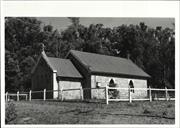
Balbarrup Rd Balbarrup
5 k from Dingup House
St. Thomas' Church
Manjimup
South West
Constructed from 1895 to 1898
| Type | Status | Date | Documents |
|---|---|---|---|
| Heritage List | Adopted | 08 Dec 2016 | |
| State Register | Registered | 23 Nov 2001 | HCWebsite.Listing+ListingDocument, HCWebsite.Listing+ListingDocument |
| Type | Status | Date | Documents |
|---|---|---|---|
| (no listings) |
| Type | Status | Date | Grading/Management | |
|---|---|---|---|---|
| Category | ||||
| Aboriginal Heritage Sites Register | Interim | |||
| Classified by the National Trust | Classified | 07 Sep 1987 | ||
| Register of the National Estate | Nominated | 09 Aug 1988 | ||
| Register of the National Estate | Identified Through State Process | |||
| Municipal Inventory | Adopted | 10 Jul 1997 | Category A+ | |
Sound condition with only minor vandalism damage
| Library Id | Title | Medium | Year Of Publication |
|---|---|---|---|
| 5189 | St Thomas' Church, Dingup : final report : a report on the conservation works funded under the Heritage Grants Program 1999/2000 to St Thomas' Church, Dingup. | Heritage Study {Other} | 2001 |
| 4019 | St Thomas' Church at Dingup Conservation Plan | Heritage Study {Cons'n Plan} | 1999 |
Individual Building or Group
| Epoch | General | Specific |
|---|---|---|
| Present Use | EDUCATIONAL | Combined School |
| Original Use | RELIGIOUS | Church, Cathedral or Chapel |
| Other Use | GOVERNMENTAL | Office or Administration Bldg |
| Style |
|---|
| Vernacular |
| Type | General | Specific |
|---|---|---|
| Wall | STONE | Local Stone |
| Roof | METAL | Corrugated Iron |
| General | Specific |
|---|---|
| SOCIAL & CIVIC ACTIVITIES | Religion |
| DEMOGRAPHIC SETTLEMENT & MOBILITY | Settlements |
| SOCIAL & CIVIC ACTIVITIES | Education & science |
| DEMOGRAPHIC SETTLEMENT & MOBILITY | Technology & technological change |
| OCCUPATIONS | Timber industry |
| TRANSPORT & COMMUNICATIONS | River & sea transport |
This information is provided voluntarily as a public service. The information provided is made available in good faith and is derived from sources believed to be reliable and accurate. However, the information is provided solely on the basis that readers will be responsible for making their own assessment of the matters discussed herein and are advised to verify all relevant representations, statements and information.
Constructed from 1894, Constructed from 1895
Representativeness, Rarity, Aesthetic, Social, Scientific and Historic
· Rural setting; · Prominent streetscape value; · Single storey; · Rectangular with apse added at front; · Soapstone walls with cement grouting; · High pitched corrugated iron roof; · Gothic arched windows; · Fireplace and chimney at rear of building; · Prominent timber cross on roof, and; · Timber post and rail fence surrounds church. For a more detailed description refer to: Palassis Architects, ‘St Thomas’ Church at Dingup, Conservation Plan’, prepared for Manjimup Historical Society on behalf of the Anglican Diocese of Bunbury, June 1999.
The church at Dingup was built in 1894-5 by Thomas Giblett, the eldest son of John and Ann Giblett who were the first settlers in the Manjimup district. The Giblett family had taken up land at Balbarrup in 1862. Thomas and his wife Maria lived on a property at Dingup, 4km south of the church (Refer Dingup Homestead, Central Ward). The stone for the church was quarried from the Giblett family property at Balbarrup with broad axes and saws. The blocks of stone were then transported by bullock wagons to the church site. The building was completed and licensed for use as a church by Bishop C.O.L Riley on 25 June 1895. It was extended by the addition of an apse in 1897/8. The church was also used as a schoolhouse around 1903, with the teacher living at Dingup House. The building has a fireplace and chimney probably due to its dual function as a school. It was only consecrated as St Thomas Church much later in 1923. Important conservation work was carried out on the building in recent times. This was funded by community donations, grants from the Shire of Manjimup and through the 1999/2000 heritage Grants Program of the Heritage Council of WA.
Integrity: Very Good Authenticity: Very Good
Good
| Ref ID No | Ref Name | Ref Source | Ref Date |
|---|---|---|---|
| Bennit C: "L0ocal History" | Dingup House | ||
| Palassis Architects: "St Thomas’ Church at Dingup, Conservation Plan’, prepared by Palassis Architects for the Manjimup Historical Society on behalf of the Anglican Diocese of Bunbury". | 1999 | ||
| Register of Heritage Places – Assessment Documentation, | HCWA | ||
| Heritage and Conservation Professionals: "Shire of Manjimup Municipal Heritage Inventory". | Shire of Manjimup | 1995 Adopted 1997 | |
| Berry C: "The history, landscape and heritage of the Warren district". | Manjimup Historical Society | 1987 |
| Owner | Category |
|---|---|
| Anglican Diocese | Church Property |
This information is provided voluntarily as a public service. The information provided is made available in good faith and is derived from sources believed to be reliable and accurate. However, the information is provided solely on the basis that readers will be responsible for making their own assessment of the matters discussed herein and are advised to verify all relevant representations, statements and information.
Collins
REGISTERED AS PART OF PEMBERTON-NORTHCLIFFE RAILWAY Sect 75 at 179.402 km Map 1 XG4; west of 150 Glauders Rd, Collins
Manjimup
South West
Constructed from 1930 to 1978
| Type | Status | Date | Documents |
|---|---|---|---|
| (no listings) |
| Type | Status | Date | Documents |
|---|---|---|---|
| (no listings) |
| Type | Status | Date | Grading/Management | |
|---|---|---|---|---|
| Category | ||||
| Statewide Lge Timber Str Survey | Completed | 11 Dec 1998 | ||
04637 Pemberton-Northcliffe Railway & Railway Station
Other Built Type
| Epoch | General | Specific |
|---|---|---|
| Present Use | Transport\Communications | Rail: Other |
| Original Use | Transport\Communications | Rail: Other |
| Type | General | Specific |
|---|---|---|
| Other | METAL | Steel |
| Other | TIMBER | Other Timber |
| General | Specific |
|---|---|
| TRANSPORT & COMMUNICATIONS | Rail & light rail transport |
This information is provided voluntarily as a public service. The information provided is made available in good faith and is derived from sources believed to be reliable and accurate. However, the information is provided solely on the basis that readers will be responsible for making their own assessment of the matters discussed herein and are advised to verify all relevant representations, statements and information.
Tynans Rd Jardee
Res 14622 Loc 13363
Teachers Quarters
Manjimup
South West
Constructed from 1954
| Type | Status | Date | Documents |
|---|---|---|---|
| (no listings) |
| Type | Status | Date | Documents |
|---|---|---|---|
| (no listings) |
| Type | Status | Date | Grading/Management | |
|---|---|---|---|---|
| Category | ||||
| Municipal Inventory | Adopted | 10 Jul 1997 | Category C | |
01506 Jardee School (fmr)
Individual Building or Group
| Epoch | General | Specific |
|---|---|---|
| Present Use | RESIDENTIAL | Single storey residence |
| Original Use | EDUCATIONAL | Housing or Quarters |
| Style |
|---|
| Federation Anglo-Dutch |
| Federation Academic Classical |
| Type | General | Specific |
|---|---|---|
| Wall | TIMBER | Other Timber |
| Roof | METAL | Corrugated Iron |
| General | Specific |
|---|---|
| SOCIAL & CIVIC ACTIVITIES | Education & science |
This information is provided voluntarily as a public service. The information provided is made available in good faith and is derived from sources believed to be reliable and accurate. However, the information is provided solely on the basis that readers will be responsible for making their own assessment of the matters discussed herein and are advised to verify all relevant representations, statements and information.
Constructed from 1954
Aesthetic and Historic
· Single storey house; · Timber walls; · Hipped corrugated iron roof; · Many changes from original, and; · Appears to be two residences joined by a walk way.
In 1854 the first steam mill of any size in the Colony was established by H Yelverton at Quindalup, near Busselton. In the early 1890s the Millar brothers saw the value of karri as a hardwood, and cut karri in the Denmark area to supply to the English and European markets. The State Government entered the arena with the establishment of the State Saw Mills at Deanmill and Big Brook (now Pemberton) after 1913. Timber production has been a major industry in the Shire of Manjimup since that time. The town site of Jardee is located in the south west region, 5 km south south west of Manjimup. The Government established a railway siding named Jardanup here in 1912, following the completion of the Bridgetown- Wilgarup railway in 1911. Jardanup was the terminus of the railway, and serviced the No. 1 State Saw Mill, built here in 1912. In 1925 the railway siding name was changed to Jardee because of confusion with Dardanup, and when the government gazetted a townsite here in 1927, it was also named Jardee. The name was proposed by the Warren Roads Board, and appears to be a made up name, derived from the Aboriginal name Jardanup, and Deeside, the name of a historic property in the district. The children of the timber workers at Jardanup were initially obliged to walk to Manjimup to attend school at that centre. This endured until John Whitecross Lyall, Manager of the Wilgarup Karri and Jarrah Mill at Jardanup arranged for the provision of a building to be used as a school. This one room school was opened on October 1912 with 21 pupils. GR Scott was the teacher. In August 1913 a purpose built school with two classrooms was built on the same school site. However, it was not until 1954 that a house was provided for teachers. Up until that time teachers boarded at various places around the town. In 1972 the school was closed and the students of Jardee were from that time on conveyed to Manjimup school by bus. The school building was purchased by the Manjimup Shire Council for community use and became a venue for the Manjimup Art Society. The teacher’s house was used to accommodate teachers appointed to Manjimup until it was eventually sold. In 2004 the school teacher’s house was privately occupied. Refer to 16.4 for more historical notes
Integrity: Moderate Authenticity: Low
Fair
| Ref ID No | Ref Name | Ref Source | Ref Date |
|---|---|---|---|
| Evans D;"Interview-History of Jardee School" | Herittage Today | 2004 | |
| http://www.dli.wa.gov.au/corporate.nsf/web/History+of+country+town+ names+-+m |
This information is provided voluntarily as a public service. The information provided is made available in good faith and is derived from sources believed to be reliable and accurate. However, the information is provided solely on the basis that readers will be responsible for making their own assessment of the matters discussed herein and are advised to verify all relevant representations, statements and information.
Lot 555 Tynans Rd Jardee
Manjimup
South West
Constructed from 1912
| Type | Status | Date | Documents |
|---|---|---|---|
| Heritage List | Adopted | 08 Dec 2016 | |
| State Register | Registered | 03 Dec 2013 | HCWebsite.Listing+ListingDocument, HCWebsite.Listing+ListingDocument |
| Type | Status | Date | Documents |
|---|---|---|---|
| (no listings) |
| Type | Status | Date | Grading/Management | |
|---|---|---|---|---|
| Category | ||||
| Municipal Inventory | Adopted | 10 Jul 1997 | Category C | |
Individual Building or Group
| Epoch | General | Specific |
|---|---|---|
| Present Use | SOCIAL\RECREATIONAL | Other Community Hall\Centre |
| Original Use | EDUCATIONAL | Combined School |
| Style |
|---|
| Vernacular |
| Type | General | Specific |
|---|---|---|
| Wall | TIMBER | Weatherboard |
| Roof | METAL | Corrugated Iron |
| General | Specific |
|---|---|
| OCCUPATIONS | Intellectual activities, arts&craft |
| SOCIAL & CIVIC ACTIVITIES | Education & science |
| SOCIAL & CIVIC ACTIVITIES | Sport, recreation & entertainment |
| SOCIAL & CIVIC ACTIVITIES | Community services & utilities |
| DEMOGRAPHIC SETTLEMENT & MOBILITY | Settlements |
This information is provided voluntarily as a public service. The information provided is made available in good faith and is derived from sources believed to be reliable and accurate. However, the information is provided solely on the basis that readers will be responsible for making their own assessment of the matters discussed herein and are advised to verify all relevant representations, statements and information.
Constructed from 1913, Constructed from 1912
Aesthetic, Historic, Representativeness and Social
The former school at Jardee is a group of buildings, which includes a 1912 single roomed school and a two roomed purpose built school opened in 1913. The 1912 building is constructed form weatherboard with a corrugated iron gabled roof. The building has porches on both sides of the building and is raised off the ground by timber stumps. The 1913 building is a well proportioned rectangular building with two classrooms. It is built from weatherboard and corrugated iron. Each room has a fireplace with a tall brick chimney. The tall many paned windows are a feature on the east side of the building. The out buildings on site include a lunch shed and male and female toilet facilities.
Jardee, originally known as Jarnadup, emerged as a timber milling settlement following the extension of the railway line from Bridgetown in 1911. This enabled a timber industry to be established in the district. The children of the timber workers at Jarnadup were initially obliged to walk to Manjimup to attend school at that centre. This endured until John Whitecross Lyall, Manager of the Wilgarup Karri and Jarrah Mill at Jarnadup arranged for the provision of a building to be used as a school. This one room school was opened on October 1912 with 21 pupils. GR Scott was the teacher. In August 1913 a purpose built school with two classrooms was built on the same school site. However, it was not until 1954 that a house was provided for teachers. In 1972 the school was closed and the students of Jardee were from that time on conveyed to Manjimup school by bus. The school building was purchased by the Manjimup Shire Council for community use and became a venue for the Manjimup Art Society. The teacher’s house was used to accommodate teachers appointed to Manjimup until it was eventually sold. In 2004 the school was not occupied or used. However the Manjimup Historical Society noted that there are plants remaining from a garden started as early as 1915. These historical notes were prepared by Dave Evans former resident and Parliament representative for the Shire of Manjimup.
Integrity: High Authenticity: Very high
The school rooms range from good to fair. The lunch shed however, is in poor condition.
| Ref ID No | Ref Name | Ref Source | Ref Date |
|---|---|---|---|
| Heritage and Conservation Professionals: "Shire of Manjimup Municipal Heritage Inventory". | Shire of Manjimup | 1995 Adopted 1997 |
This information is provided voluntarily as a public service. The information provided is made available in good faith and is derived from sources believed to be reliable and accurate. However, the information is provided solely on the basis that readers will be responsible for making their own assessment of the matters discussed herein and are advised to verify all relevant representations, statements and information.
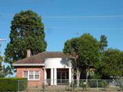
Cnr Rutherford & Moore Sts Manjimup
Manjimup
South West
Constructed from 1946
| Type | Status | Date | Documents |
|---|---|---|---|
| Heritage List | Adopted | 08 Dec 2016 | |
| State Register | Registered | 14 Dec 2001 | HCWebsite.Listing+ListingDocument, HCWebsite.Listing+ListingDocument |
| Type | Status | Date | Documents |
|---|---|---|---|
| (no listings) |
| Type | Status | Date | Grading/Management | |
|---|---|---|---|---|
| Category | ||||
| Municipal Inventory | Adopted | 10 Jul 1997 | Category A+ | |
| Aboriginal Heritage Sites Register | Interim | |||
| Classified by the National Trust | Classified | 12 Mar 2001 | ||
Good condition
| Name | Type | Year From | Year To |
|---|---|---|---|
| William Bennett | Architect | - | - |
| Nancy Allen | Architect | - | - |
| Library Id | Title | Medium | Year Of Publication |
|---|
Individual Building or Group
| Epoch | General | Specific |
|---|---|---|
| Present Use | HEALTH | Other |
| Original Use | HEALTH | Other |
| Style |
|---|
| Inter-War Stripped Classical |
| Type | General | Specific |
|---|---|---|
| Roof | TILE | Terracotta Tile |
| Wall | BRICK | Common Brick |
| General | Specific |
|---|---|
| DEMOGRAPHIC SETTLEMENT & MOBILITY | Settlements |
| SOCIAL & CIVIC ACTIVITIES | Community services & utilities |
This information is provided voluntarily as a public service. The information provided is made available in good faith and is derived from sources believed to be reliable and accurate. However, the information is provided solely on the basis that readers will be responsible for making their own assessment of the matters discussed herein and are advised to verify all relevant representations, statements and information.
Constructed from 1945, Constructed from 1946
Aesthetic, Historic, Representativeness, Social and Rarity
The Manjimup Infant Health centre (fmr) is on the corner of Rutherford and Moore St. The site comprises the clinic and a brick and tile garage. The clinic building is located centrally on the site and is set on the diagonal so the front façade faces towards the intersection of the two streets. The clinic is a single storey brick and tile building built on a domestic scale similar to houses built in the Inter-War period. It is constructed of stretcher bond brick work walls and a Marseilles patterned terracotta tile roof with lined eaves and timber windows. The main façade of the clinic is composed symmetrically with two hipped roofed wings projecting forward of the main body of the building. The main entrance to the building is central within the wall between the two wings. The entrance is housed within a semi-circular portico. Much of the architectural interest in this building is concentrated on the design of the entrance portico, which together with the symmetry of the front façade, displays a number of the characteristics of the Inter-War Stripped Classical style. Six octagonal columns support the simplified rendered entablature of the portico, bearing the words Manjimup Infant Health Centre. A simple curved balustrade runs between the columns.
These historical notes have been derived from the Heritage Places Assessment Documentation, Heritage Council Of Western Australia Compiled by Kristy Bizzaca December 2001 There was an increase in the provision of public services to the Manjimup area during the Inter-War period. This coincided with the recognition of a need for state wide infant welfare services to be set up throughout Western Australia. It was at the instigation of the Bridgetown branch of the CWA that an infant health clinic was opened at Bridgetown/ Manjimup on 29 November 1940. At the time of establishment the Bridgetown Clinic also served the Manjimup district. The Infant Health nurse based as Bridgetown travelled to the sub-centre at Manjimup one day a week to operate a clinic out of the rooms in the local CWA’s rest room (Hall). In 1943 the service was increased to two and a half days a week owing to a flourishing clinic. At some point during this growing period the Infant Health service moved from the CWA Hall to new accommodation in Brockman Street. It appears in c1943 the Manjimup Infant Health Centre became increasingly autonomous from the Bridgetown clinic. Records show that the Manjimup Infant Health Centre was administered by its own committee as early as 1941/1942. The committee was responsible for paying the Sister’s wages and the running expenses of the clinic, which included raising money for rent and maintenance costs. In January 1944 Dr Eleanor Stang, Medical Supervisor of Infant Health, visited Manjimup. Her meeting with the Infant Health nurse, Sister Page, and the Manjimup committee, stimulated the local community to raise funds for the building of a new Infant Health Centre. A baby competition was organized by the Committee and the local community supported the concept by raising over 1,400 pounds. Further money was secured form the Lotteries commission and the Manjimup Road Board. In 1944 Nancy Allen of the architectural firm of WG Bennett drew up plans for the proposed Manjimup Infant Health Centre. The building comprised the rooms of the centre and the living quarters for the nurse. In February 1945 the tender for the construction of the Infant Health Centre was awarded to builder James Rea. Records show that the Infant Health Clinic formed part of a larger civic centre to be located at the site. However, the construction of the community centre did not go ahead. The Manjimup Road Board as owners of the property became responsible for the Infant Health centre’s maintenance. The Infant Health Centre was opened to mothers on 4 February 1946. Much to the consternation of Sister Hernan the new centre was not well attended in the first few months. The new clinic was deemed to far from the hub of the town. Attempts to solve the problem included a free bus to transport mothers and their babies to this vital service. The centre was officially opened on 5 July 1946, by this time the earlier concerns of attendance seem to have died down. In 1994 the clinic was enlarged to takeover the residential facilities. It was at this stage the main entrance was changed to the north side (the former front door of the Sister’s living quarters.) In April/May 2000 the Manjimup Infant Health Clinic was relocated to a new building. It is interesting to note that the Manjimup Infant Health Clinic is still administered by a management committee, one of the few remaining clinic in WA to be operated this way. In 2005 the Infant Health Centre (fmr) was occupied and being used as a Shire office.
Integrity: Fair Authenticity: Very high
Good
| Name | Type | Year From | Year To |
|---|---|---|---|
| Nancy Allen of WG Bennett | Architect | 1944 | 1946 |
| Ref ID No | Ref Name | Ref Source | Ref Date |
|---|---|---|---|
| Apperley, R., Irving, R., Reynolds, P: "A Pictorial Guide to Identifying Australian Architecture". | Angus and Robertson, | 1989 | |
| Heritage Council Of Western Australia Register of Heritage Places Assessment Documentation | HCWA | 2001 | |
| Heritage & Conservation Professionals; "Shire of Manjimup Municipal Heritage Inventory". | Shire of Manjimup | 1995 Adopted 1997. |
| Owner | Category |
|---|---|
| Shire of Manjimup | Local Gov't |
This information is provided voluntarily as a public service. The information provided is made available in good faith and is derived from sources believed to be reliable and accurate. However, the information is provided solely on the basis that readers will be responsible for making their own assessment of the matters discussed herein and are advised to verify all relevant representations, statements and information.
Lot 12152 Karri Hill Rd Northcliffe
Tobacco Kilns
Manjimup
South West
Constructed from 1950 to 1951
| Type | Status | Date | Documents |
|---|---|---|---|
| Heritage List | Adopted | 08 Dec 2016 | |
| State Register | Registered | 20 Jan 2006 | HCWebsite.Listing+ListingDocument, HCWebsite.Listing+ListingDocument |
| Type | Status | Date | Documents |
|---|---|---|---|
| (no listings) |
| Type | Status | Date | Grading/Management | |
|---|---|---|---|---|
| Category | ||||
| Municipal Inventory | Adopted | 28 Aug 2008 | Category A+ | |
| Library Id | Title | Medium | Year Of Publication |
|---|---|---|---|
| 7923 | Tobacco grading shed, Watermark kilns, Northcliffe. | Heritage Study {Cons'n Plan} | 2006 |
| 7025 | Images CD No. 29 : assessment images : Watermark Kilns, House Briald Place, Pemberton Tramway, Church of Christ Tabernacle. | C D Rom | 2004 |
Individual Building or Group
| Epoch | General | Specific |
|---|---|---|
| Original Use | FARMING\PASTORAL | Other |
| Present Use | FARMING\PASTORAL | Other |
| Style |
|---|
| Vernacular |
| Type | General | Specific |
|---|---|---|
| Roof | METAL | Corrugated Iron |
| Wall | METAL | Other Metal |
| Roof | METAL | Zincalume |
| Wall | ASBESTOS | Other Asbestos |
| General | Specific |
|---|---|
| OUTSIDE INFLUENCES | World Wars & other wars |
| OCCUPATIONS | Rural industry & market gardening |
This information is provided voluntarily as a public service. The information provided is made available in good faith and is derived from sources believed to be reliable and accurate. However, the information is provided solely on the basis that readers will be responsible for making their own assessment of the matters discussed herein and are advised to verify all relevant representations, statements and information.
Constructed from 1950, Constructed from 1951
Historic, Aesthetic, Rarity and Scientific
Watermark Kilns, Northcliffe is a collection of former tobacco farm buildings in a farmland setting, including a framed and asbestos clad drying shed with an iron roof, framed and custom orb Colourbond clad single and twin kilns adapted for holiday accommodation with Zincalume custom orb roofs, single men’s or worker’s quarters (fmr), and a framed and asbestos clad former soldier settler’s homestead with an iron roof. These were built to standard plans as part of the development of a tobacco farm for Roy and Peg Bell, under the War Service Land Settlement Scheme in c. 1950-51. In 2000-03, the kilns and workers’ quarters have been extensively repaired and converted to farm stay accommodation by Trevor and Jeanette Hulcup. So far as possible, re-cycled materials have been employed. As the timber corner posts of the kilns had rotted off the floor plates and were sitting on the ground, with only the cladding holding the buildings up, they were jacked up and the studs and floor plates replaced as required. A new sand pad was put in and a concrete base with new floor plates bolted to it. The kiln buildings have been re-roofed, maintaining the original roof lines and the ventilation structure, with Perspex fitted in place of mesh to either side of this portion of the roof. Roof timbers were retained where possible, and also the twin ventilation slats, whose pulley mechanism was transferred from the exterior to the interior to suit the buildings’ change in use. The external corrugated iron cladding of the buildings was replaced with Colourbond of a similar gauge, and windows were fitted to each building. The former workers’ quarters were extended at either side and a veranda added to convert it to accommodation suitable for disabled access. The original fireplace was retained. In 2003, termite damage to the soldier-settler’s homestead, in particular to replacement karri beams, necessitated demolition of the fireplace and chimney, and interior stud walls and roofing timbers have been exposed for inspection and treatment to ensure removal of affected timber and eradication of the termites. In 2004, the Hulcups applied for a grant under the Heritage Grants Program 2004/05 to restore the drying/grading shed, which retained the grading bench and some of the original wall lining. The stumps have been rotting at ground level, causing the floor to slump; the interior lining has deteriorated and sections have been falling; some windows require re-glazing and window frames require replacement or repair. Subsequent to its restoration, they propose utilizing the drying shed for interpretive purposes. At some future date, they would also like to renovate the homestead so that future visitors may see the group of buildings which formed a typical War Service Land Settlement Scheme tobacco farm.
These historical notes have been taken directly from the Documentary Evidence prepared by HCWA in the Register of Heritage Places Assessment 31 January 2005. The kilns were built to standard plans as part of the development of a tobacco farm for Roy and Peg Bell, under the War Service Land Settlement Scheme in c. 1950-51. In 2000-03, the kilns and workers’ quarters have been extensively repaired and converted to farm stay accommodation by Trevor and Jeanette Hulcup. In the early 1850s, tobacco was first cultivated in the eastern colonies of Australia. In 1854, it was suggested that tobacco be cultivated in Western Australia. In 1860-62, Ralph Mews experimented with tobacco growing, and Bishop Salvado grew a crop at Victoria Plains in the early 1860s, but concluded that the high rate of tax on tobacco precluded a profitable industry. In 1863, James Morgan’s efforts at Avon Valley also came to naught. In the 1860s, the Muirs grew tobacco at Deeside, in the Warren district, mainly for medicinal purposes. During the American Civil War period, when imported tobacco leaf was in short supply, attempts were made to grow it at Hester, near Bridgetown, and also in New South Wales and Victoria, and it was also being grown in Queensland by 1884. In 1904, Peter Michelides (arr. 1901), who had prior experience in cigarette manufacture in Egypt, set up a tobacco manufacturing business in Murray Street, Perth, utilising tobacco imported from Turkey and Greece. Experimental plantings of tobacco by two ex-Victorian farmers at Waroona caught his interest, and led the Michelides family to experiment with tobacco crops at Waroona under the direction of an Egyptian grower whom they brought to Australia, but the soil and rainfall proved not to be suitable. In 1912, the government nursery at Hamel successfully grew tobacco. However, it was concluded that production would be uneconomical without the protection of import duties, and there were no further investigations into the viability of commercial production until 1923. The future site of Watermark Kilns, Northcliffe was first cleared and the first house built as part of the Group Settlement Scheme. In 1931, Nelson Location 10251, which would later become Nelson Location 12152, the site of Watermark Kilns, Northcliffe, was first registered in the ownership of Stanley Bassett.5 Details of his use of the land have not been ascertained to date, and by the post- World War Two period, it was no longer in his ownership. The Group Settlement Scheme proved to be ‘a social and financial tragedy’, and the State eventually bore a loss of more than £6.5 million. In 1923, the Agriculture Department carried out successful trial plantings of tobacco at Perth. This was followed by trial plantings at Peel Estate, Coolup, Boyanup, Bridgetown and Manjimup in November, but the first two failed, and only poor growth was obtained from the latter. In 1923-24, tobacco was grown and harvested at Manjimup by J. Murphy and J. Turner, but they experienced difficulty in curing the leaf. Samples of this tobacco was sent to tobacco manufacturer Michelides Limited in Perth, and also to Melbourne Group Settler Herbert John ‘Jack’ Limmer, who was also associated in this venture, and who established a plantation at Dixvale in 1926, where the first tobacco curing kiln in the Victoria was built. In 1928, the first crop of tobacco grown by Macedonians Nick Palasin, Tom Milentis, Vic Milentis, and Louis Mitchell failed, but thereafter they were successful in its cultivation. Macedonians would predominate in tobacco growing in Western Australia throughout its history. In 1928-29, experimentation by the Australian Tobacco Organisation also established that the soil and climate in the Manjimup district was suitable for tobacco growing. In 1930, the first commercial crop of 25 acres of tobacco was planted, which proved successful. Consequently, in 1931-32, the acreage planted increased to 348 acres, which yielded 211,230 lbs., the total value of the crop being £18,000. It was in this year that Michelides established his first tobacco plantation. These results encouraged more extensive plantings of 466 acres in 1932-33. Through the 1930s and into the World War Two period, the area under tobacco was centred around Manjimup. The initial costs of clearing the heavily forested land for tobacco planting were heavy. The crop was grown and harvested during the spring and summer months on water retentive soils. Other than Michelides’ tobacco manufacturing company’s plantations, most operations were on a small scale, with plantings ranging in area from four to 10 acres, ‘the majority worked by Southern Europeans.’ Growing tobacco was labour intensive, and often all family members would be engaged in the various tasks involved. By the late 1930s, tobacco farming in Western Australia was well established. Most of the practices which had evolved would continue through into the post World War Two period, as did the general requirements with regard to the necessary buildings. In December 1938, in an article on the harvesting and curing of tobacco leaf, the Agriculture Department’s tobacco adviser, A. Sharp, described the various buildings which were part of the operation at this period, and which were to remain much the same throughout the period in which tobacco was commercially grown in Western Australia, i.e. through to the early 1960s. The stringing shed was ‘usually a more or less temporary erection of hessian stretched over bus poles’, which was conveniently located in proximity to ‘the curing barns’, as the kilns were sometimes known. The size and number of barns was dependent on the extent of the tobacco plantation. Most in this State were small operations, of five to 15 acres, for which ‘a number of small barns, each 12 ft. by 12 ft. inside measurement, and carrying four tiers of leaf, will be found most suitable’, one barn being sufficient for each four acres of crop, whilst for larger operations, ‘barns 16 ft. by 16 ft. with four or five tiers’ would suffice for each seven acres. Sharp advised that it was preferable for the barns to be built ‘in a fairly well sheltered position on slightly sloping ground, the furnaces being built on the lower side in order to lessen the amount of excavation necessary.’ The framing of each barn should be 4ins. x 2ins. jarrah timber, ‘with wall studs set at 2 ft. centres’, the building being lined with timber, corrugated iron, asbestos-cement sheets, or re-cycled hessian bags, sewn together and cement washed, which was the cheapest option. The smaller barn would be readily heated by a single brick furnace, whilst two were recommended for a larger barn, with the flue pipes arranged as indicated in the accompanying ground plans. Drawings show the side section and sectional elevation of a 12 ft. x 12 ft. barn, with an air inlet at ground level and an open ridge ventilator at the apex, controlled from the exterior, for efficient ventilation was essential. The 16 ft. x 16 ft. barn was designed on similar lines, other than arrangement of furnaces and flues. Curing the tobacco leaf generally took three to five days, by which time the colour had been fixed and the leaf was brittle and dry. In the next stage, known as conditioning, a certain amount of moisture was re-absorbed, the optimum being a moisture content of around 12%, before the leaf was ‘bulked down’ in the bulk shed, often referred to as the drying shed, which generally included the grading shed under the same roof.14 This building was ‘a well-built shed preferably set on stumps at least two feet off the ground.’ Bulking involved making a stack, 3-4 ft. wide, where the leaf was stacked ‘with the butts to the outside’, and, as each cure was added to the stack, two or three heavy planks would be placed ‘on top to consolidate the bulk and exclude air as much as possible.’ It was recommended that the bulks be covered with hessian to protect the leaf from sunlight, and ‘later on, against excessive absorption of moisture from the air after the Autumn rains have set in.’ In March 1939, Sharp described the grading and marketing of tobacco leaf. The grading shed should be built well off the ground, and lined with either asbestos-cement sheets or other damp proof material to prevent moisture during handling leading to mould. The south wall should be fitted with ample windows for diffused light on the grading bench, which was fitted with compartments for the various grades of leaf. Grading generally took place in May-July. It was important that direct light not fall on the tobacco leaf, as its true colour cannot be judged in direct light. In 1939-40, 1,019 acres of tobacco were planted in Western Australia. After war-time restrictions limited tobacco imports, the Commonwealth urged for increased home production. The State government advanced growers £10 per acre to assist in the costs of planting and cultivation, and 1,365 acres were planted in 1940-41, of which Michelides grew 650 acres. Meanwhile, in 1943, the Commonwealth Government appointed the Rural Reconstruction Commission to examine the problems that had been faced by rural industries in the inter-war and World War Two periods. In 1944, the Commission reviewed the post-World War One soldiersettlement schemes and outlined proposals for post-World War Two reconstruction. In 1945, the War Service Land Settlement Agreement Act was passed whereby the Commonwealth would provide funds for the purchase and development of farms in a scheme to be administered by the State. Ex-servicemen were to be carefully selected and trained before taking up farming properties for development in areas and with products ‘where reasonable prospects of economic success were evident.’ The structural improvements were to be purchased by the settlers, who entered into a lease in perpetuity of the land and ground improvements, with an option to purchase the freehold. In the late 1940s, tobacco production in Western Australia increased with some growers returning to this crop after costs increased in the potato industry and with growing confidence in the stability of the tobacco industry. It was proposed to expand tobacco growing in Western Australia through the War Service Land Settlement Scheme, in the belief that it could be grown successfully beyond the Manjimup-Pemberton area, through ‘a belt embracing Busselton, Karridale, Manjimup, Northcliffe, Walpole and Denmark’ where 50 War Service tobacco farms were to be established, on Crown land, which had been previously forfeited or purchased or purchased for this purpose. After a 12 month training programme in tobacco growing, the ex-servicemen were to be allocated land to develop as a tobacco farm. In 1949, the first 20 trainees commenced at the training school at Manjimup, of whom 17 moved to farms in 1950. In 1950-52, two further training schools would be held. Some of the lots allocated to ex-servicemen, including Nelson Location 12152, had been part of the inter-war Group Settlement Scheme. The soldier-settler was provided with sufficient funding for growing his crop and living costs. After the crop was sold, these costs would be re-couped, along with re-payments on the land and machinery. Once the settler’s farm was self-supporting, its administration was to transfer from the Department of Lands and Surveys to the Rural & Industries Bank. The practices and the buildings associated with tobacco farming changed little in the post-war period, and the tobacco farm operation that would be developed, in the early 1950s, at Nelson Location 12152 by Roy and Peg Bell followed the established pattern. Ex-serviceman Roy Bell and his wife, Peg, both of whom had previous experience of farming, were living in Fremantle when they decided to take up a soldier-settlement tobacco farm. Roy moved to the training school at Manjimup, whilst Peg remained in Fremantle. At this period, Cross Hickory was the tobacco grown at Manjimup. After Peg Bell read an article about the Smith Brothers growing a new, larger leafed variety, Virginia Gold, at Nathalia in South Australia, Roy Bell wrote to them, and in reply they sent a teaspoon of seed. He would be one of the first farmers in Western Australia to plant this variety, which became widely used. After Roy Bell completed his training course, the family took up occupation of their tobacco farm at Northcliffe, at Nelson Location 12152, which he had selected ‘as it had the right soil and was well drained.’ In 1949-50, there were 68 tobacco growers. In 1950-51, including the 17 recently graduated ex-servicemen, there were 99 growers, 20 of whom were ex-servicemen, of whom seven were at Karridale and nine at Northcliffe. The total acreage under tobacco was increased from 670 acres to 930 acres. This was the first year in which tobacco was commercially grown at Northcliffe, and the nine growers harvested a total of 75 acres. In 1951-52, 1,230 acres was planted, the greatest acreage since the early 1940s. At Northcliffe, there was considerable expansion, with 24 growers, including Roy and Peg Bell, planting 199 acres. Houses provided to the soldier-settlers were timber-framed asbestos clad with an iron or asbestos roof. The Bells’ house was built on the site of the original group settler’s house, where a rose bush and a few bulbs were all that remained of the earlier garden.32 In the 1950s, a photograph shows the timber framed seed beds in the foreground, the double kiln and the drying/grading shed near by, and the single kiln and the workers’ hut a short distance away. A second photograph shows the Bell’s house, the machinery shed and the dairy shed, both of which remained from the earlier Group Settler’s farm. There is also a small shed which the Bells had re-located from beside the house to the site shown in the photograph to house Peg’s ducks. There was also the small stringing on shed, which was located between the kilns. Roy Bell ‘worked very hard to make a success of tobacco growing.’ He constructed the seed beds of timber with rolled calico tops to cover the seedlings at night. In June-July, the seed was sown. Benzol, was placed in small disks, evaporated and these measures prevented mould. At 6 ins to 8 ins. in height, about mid-October, the seedlings were planted out in the 10 acres which had been prepared, including the application of fertiliser. During the growing period, the fields were weeded, and insecticide applied to the crop until it was ready to harvest in late November, and through December-January. At this stage, many hands were required on the tobacco farm, and the Bells appreciated the assistance of numerous local dairy farmers who came to work there through to 4 p.m., when they had to return to their farms for milking. The picked leaves were placed in bags, then taken to the shed for stringing before being placed in the kilns to be cured. The temperature was raised to 50 degrees as the leaf turned from green to lemon, and ‘then fixed at that colour by raising the temperature rather quickly and holding that temperature for anything up to 50 hrs.’ Then the fires were extinguished, and the tobacco ‘allowed to take up moisture so it could be taken from the kiln to the grading shed’. Roy Bell would sleep the night in the stringing-on shed, getting up at intervals to fuel the kiln fire and check the thermometer. At ‘picanniny daylight’, he would call Peg to come and assist him in shifting the cured tobacco to the grading shed before the atmosphere became too dry. The cured tobacco was stacked and stored in bulk in the grading shed, which was simply furnished with a long table, ‘divided into small slots where each leaf was placed’ according to its grade. Four girls were employed for this task, each with her own division. There was also a heater and a press. After grading into six grades, from poorest to best, in February-April, the tobacco continued to be stored in this shed, where it was compressed into bales ready for transport to Perth for sale at auction in May. Whilst the Bells worked full-time on the farm, assisted by one or two tobacco workers accommodated in the small workers’ hut near the single kiln, other workers were mainly seasonal. They lived elsewhere and travelled to the farm when required, either on a daily basis or camping in tents at the farm. Joanne Flanagan recollects working on three tobacco farms in Karri Hill Road, including the Bells’. The farmers ‘got together’ and the workers would spend a day on each farm, before moving on to the next. Roy Bell was responsible for several further innovations in tobacco farming subsequent to his introduction of the Virginia Gold variety. He imported Guinea Gold tobacco seed from Queensland, which he grew successfully, and which at sale topped the Western Australian price record. He developed a different method of stringing. Rather than putting the tobacco leaf on sharpened wires before it was placed in the kilns, he tied it to stocks, which were safer and more easily handled. He installed kerosene heaters to the kilns, enabling him to set the temperature ‘and relax.’ By February 1955, there were eight kerosene fed kilns installed by seven growers in the Manjimup district. The Agricultural Department and notable visitors who included a South African tobacco expert, Tom Harvey, took ‘great interest’ in the Bells’ crops and innovative practices, and the Department gathered seed from the Bells’ tobacco farm. The rainfall in the Northcliffe area proved to be too variable for tobacco growing. The Bells were often concerned about even having sufficient rain water for the house through summer, and there was no irrigation for crops. Whilst Roy Bell’s care and expertise enabled the Bells to continue farming tobacco for a longer period, many of the 56 War Service Settlement tobacco farms in the Manjimup district failed by the mid-1950s, and Commonwealth support was withdrawn. Some of the farmers remained on their properties and converted to dairy farming, some transferred to other farming properties, and a number of the tobacco farms were simply left abandoned. The Scheme demonstrated that tobacco could be grown on the farms, but Thomas P. Field has suggested that due to the refusal of the soldier-settlers “to enlist their families for full-time farm work” they were “unable to provided reasonable economic returns.” Similarly, B. Giles noted that of 200 tobacco growers in 1959, only five were of British origin, and maintained ‘Australian men and their families were not prepared to work hard enough. ’ In the post-war period, filter tipped cigarettes grew in popularity. After post-war restrictions were lifted, the multi-national companies made in-roads into the Australian market with their cheaper product, and, along with the advent of flip-top cigarette boxes, reduced the economic viability of Michelides Ltd., which in turn adversely affected the Western Australian tobacco industry. In the late 1950s, tobacco buyers were increasingly critical of Western Australian tobacco leaf whose chloride content resulted in a poor burn. The Department of Agriculture carried out trials of different varieties, fertilisers, and crop rotation, but the problem persisted. In the late 1950s and early 1960s, the downward trend in sales of Western Australian tobacco continued, and less tobacco was planted each year in view of uncertainty whether the crop would be sold or rejected. By 1959, only three of the 56 original soldier-settlers were still growing tobacco. Eventually, the Bells made the decision to leave their farm. On 10 February 1960, the Minister for Lands was granted Nelson Location 12152, 107 acres one rood 17 perches in area, and was registered as the proprietor on 15 February 1960. At this date, there was no electrical power to the place as the electricity grid was not extended to Northcliffe until the 1960s. Nelson Location 12152 continued in the ownership of the Minister for Lands to 29 March 1968, when it was transferred to Philip Richard Hazelgrove, mill hand, of Northcliffe. In the same year, a caveat on the place was registered. The place was utilised for various agricultural purposes, with the kilns and grading/drying shed utilised for hay barns, storage etc. The homestead continued to be occupied as a residence by consecutive owners, who made various alterations including laying parquetry timber flooring to some rooms, enclosing verandas and sleep-outs, re-lining internal walls, installing some timber panelling, fitting a false ceiling, and building a lean-to addition at the rear. On 24 March 1976, the place was transferred to Marie Longmire, married woman, of Northcliffe, who owned the place for nearly four years. On 26 February 1980, the place was transferred to Phillip Charles Bruce, plant operator, and Judy Ann Bruce, of Manjimup, as joint tenants, who mortgaged the place to the preceding owner, Marie Longmire, now a widow. On 15 December 1983, the place was transferred to Pascoe Holdings Ltd., of Perth. On 24 June 1997, the place was transferred to Trevor John Hulcup and Jeanette Erica Hulcup, of Swanbourne. Initially, they used it as a holiday home/weekender, utilising the homestead for accommodation. It was re-stumped and a replacement hot water system was installed. They lived there until their new, permanent residence, set at a distance from the group of tobacco farm buildings, was completed in late 2002. Over a four year period, the Hulcups have undertaken various works to convert the double kiln, single kiln and workers’ quarters to farmstay accommodation, under the name Watermark Kilns, Northcliffe, at an estimated cost of $150,000.
Integrity: Moderate Authenticity: Moderate
Good
| Ref ID No | Ref Name | Ref Source | Ref Date |
|---|---|---|---|
| Register of Heritage Places Assessment | Heritage Council of WA | 2005 |
This information is provided voluntarily as a public service. The information provided is made available in good faith and is derived from sources believed to be reliable and accurate. However, the information is provided solely on the basis that readers will be responsible for making their own assessment of the matters discussed herein and are advised to verify all relevant representations, statements and information.
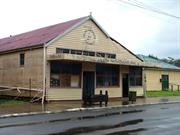
Wheatley Coast Rd Northcliffe
Giblett and Johnston’s Northcliffe Trading Co
The Northcliffe Craft Store, Environment Cent
Manjimup
South West
Constructed from 1924
| Type | Status | Date | Documents |
|---|---|---|---|
| Heritage List | Adopted | 08 Dec 2016 | |
| State Register | Registered | 28 Nov 2003 | HCWebsite.Listing+ListingDocument, HCWebsite.Listing+ListingDocument |
| Type | Status | Date | Documents |
|---|---|---|---|
| (no listings) |
| Type | Status | Date | Grading/Management | |
|---|---|---|---|---|
| Category | ||||
| Municipal Inventory | Adopted | 10 Jul 1997 | Category A+ | |
| Aboriginal Heritage Sites Register | Interim | |||
| Library Id | Title | Medium | Year Of Publication |
|---|---|---|---|
| 5511 | Store : Northcliffe : conservation management plan. | Heritage Study {Cons'n Plan} | 2002 |
| 11458 | Northcliffe Store Wheatley Coast Rd, Northcliffe | Archival Record | 2016 |
Individual Building or Group
| Epoch | General | Specific |
|---|---|---|
| Original Use | COMMERCIAL | Shop\Retail Store {single} |
| Present Use | COMMERCIAL | Shop\Retail Store {single} |
| Style |
|---|
| Vernacular |
| Type | General | Specific |
|---|---|---|
| Wall | TIMBER | Weatherboard |
| Roof | METAL | Corrugated Iron |
| General | Specific |
|---|---|
| PEOPLE | Early settlers |
| SOCIAL & CIVIC ACTIVITIES | Environmental awareness |
| DEMOGRAPHIC SETTLEMENT & MOBILITY | Settlements |
| SOCIAL & CIVIC ACTIVITIES | Community services & utilities |
| OCCUPATIONS | Timber industry |
| DEMOGRAPHIC SETTLEMENT & MOBILITY | Immigration, emigration & refugees |
| DEMOGRAPHIC SETTLEMENT & MOBILITY | Resource exploitation & depletion |
| DEMOGRAPHIC SETTLEMENT & MOBILITY | Government policy |
| DEMOGRAPHIC SETTLEMENT & MOBILITY | Land allocation & subdivision |
| OCCUPATIONS | Commercial & service industries |
This information is provided voluntarily as a public service. The information provided is made available in good faith and is derived from sources believed to be reliable and accurate. However, the information is provided solely on the basis that readers will be responsible for making their own assessment of the matters discussed herein and are advised to verify all relevant representations, statements and information.
Constructed from 1924
Historic, Aesthetic, Representativeness, Rarity and Social
· Set close to the road; · Large single storey building; · Symmetrical façade; · Corrugated iron gable roof; · Horizontal weatherboard walls with some corrugated iron cladding; · Distinctive vernacular style; · Large banks of timber framed windows (not thought to be original), AND; · Timber entry doors.
The Northcliffe Store was constructed in 1924 and continued to provide services to the town until its closure in 2001. It was built (and extended in c1925) by John Ipsen. Ipsen was employed by the State Government to construct buildings such as houses, stores and offices for group settlement administrators. The store was important as a place where the Group Settlers bought their goods particularly in the early foundation years of Northcliffe. The store originally provided accommodation for staff and single men in the rear rooms as well as functioning as a grocery store. The store has associations with William Johnston and George Giblett entrepreneurs and store keepers. William Johnston was instrumental in facilitating a settlement and store at Northcliffe through his associations with the Premier, Sir James Mitchell. George Giblett is commemorated and recognised in the name of Giblett Forest Block in the Manjimup region. The Northcliffe Store was run as a supermarket by the Richards family from 1964 to 1985. In the 1990s the store became the premises of the Environment Centre that represented a symbol of rights for citizens to support their views in the struggle to retain old growth forests. Subsequent firebombing of the premises on two occasions elevated the value of the place in the community. For a period in the late 1990s the store was used as an Arts and Crafts Shop. In 2005 the store was unoccupied. Refer to 16.2 for more historical notes
Integrity: Moderate Authenticity: High
Poor
| Ref ID No | Ref Name | Ref Source | Ref Date |
|---|---|---|---|
| Crawford, P., and I: "Contested Country: A History of the Northcliffe Area WA". | UWA Press | 2003 | |
| Northcliffe Pioneer Museum; "Northcliffe Remembers Compilation of stories and memories of life in Northcliffe". | Dynamic Press Bunbury WA | ||
| Register of Heritage Places Assessment Documentation | Heritage Council WA, | 2003 | |
| Heritage and Conservation Professionals: "Shire of Manjimup Municipal Heritage Inventory". | Shire of Manjimup | 1995 Adopted 1997 |
This information is provided voluntarily as a public service. The information provided is made available in good faith and is derived from sources believed to be reliable and accurate. However, the information is provided solely on the basis that readers will be responsible for making their own assessment of the matters discussed herein and are advised to verify all relevant representations, statements and information.
38 Brockman St Pemberton
Cnr Brockman & Dean Sts
Methodist
Manjimup
South West
Constructed from 1926
| Type | Status | Date | Documents |
|---|---|---|---|
| Heritage List | Adopted | 08 Dec 2016 |
| Type | Status | Date | Documents |
|---|---|---|---|
| (no listings) |
| Type | Status | Date | Grading/Management | |
|---|---|---|---|---|
| Category | ||||
| Uniting Church Inventory | Completed | 01 Oct 1996 | ||
| Municipal Inventory | Adopted | 10 Jul 1997 | Category B | |
11381 Pemberton Timber Mill Workers' Cottages Precinct
Individual Building or Group
| Epoch | General | Specific |
|---|---|---|
| Present Use | RELIGIOUS | Church, Cathedral or Chapel |
| Original Use | RELIGIOUS | Church, Cathedral or Chapel |
| Type | General | Specific |
|---|---|---|
| Roof | METAL | Corrugated Iron |
| Wall | ASBESTOS | Fibrous Cement, weatherboard |
| General | Specific |
|---|---|
| SOCIAL & CIVIC ACTIVITIES | Religion |
This information is provided voluntarily as a public service. The information provided is made available in good faith and is derived from sources believed to be reliable and accurate. However, the information is provided solely on the basis that readers will be responsible for making their own assessment of the matters discussed herein and are advised to verify all relevant representations, statements and information.
Constructed from 1926
Aesthetic, Historic, Representativeness and Social
• Located in prominent position in Brockman Street; • Set in cleared grassy area; • Large rectangular building; • Steeply pitched gabled roof; • Gabled entrance porch attached to front of building; • Addition with skillion roof attached to rear of building; • Corrugated iron roof; • Timber frame with fibreboard and timber weatherboard cladding; • Arched front doorway and windows on entrance porch; • Three timber framed windows on side elevation of main building, and; • Brick ramp with metal balustrade provides access to front door.
The Uniting Church is one of a group of significant heritage buildings in Brockman St, the main street of Pemberton. The 1920s was a period of growth in Pemberton. Significant buildings sprang up in the main street, Brockman St, including the Mill Workers Hall, the School, the Pemberton Hotel, the Methodist Church, and the Picture Theatre. These are still intact today, and the main street precinct has high streetscape and heritage value. In the 1970s there was a move to merge some Christian churches in Australia. On 22 June 1977 the Uniting Church was formed as a result of a union of the Congregational Church of Australia, the Methodist Church of Australia and the Presbyterian Church of Australia. As a result this church was renamed the Uniting Church. Refer to 16.6 for more historical notes
Integrity: Good Authenticity: Good
Good
| Ref ID No | Ref Name | Ref Source | Ref Date |
|---|---|---|---|
| Heritage & Conservation Professionals; "Shire of Manjimup Municipal Heritage Inventory". | Shire of Manjimup | 1995 Adopted 1997. |
| Owner | Category |
|---|---|
| Uniting Church of Australia | Church Property |
This information is provided voluntarily as a public service. The information provided is made available in good faith and is derived from sources believed to be reliable and accurate. However, the information is provided solely on the basis that readers will be responsible for making their own assessment of the matters discussed herein and are advised to verify all relevant representations, statements and information.
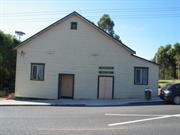
Lot 278 Brockman St Pemberton
Manjimup
South West
Constructed from 1913
| Type | Status | Date | Documents |
|---|---|---|---|
| Heritage List | Adopted | 08 Dec 2016 | |
| State Register | Registered | 15 May 1998 | HCWebsite.Listing+ListingDocument, HCWebsite.Listing+ListingDocument |
| Type | Status | Date | Documents |
|---|---|---|---|
| (no listings) |
| Type | Status | Date | Grading/Management | |
|---|---|---|---|---|
| Category | ||||
| Classified by the National Trust | Classified | 08 Jun 1998 | ||
| Aboriginal Heritage Sites Register | Interim | |||
| Municipal Inventory | Adopted | 10 Jul 1997 | Category A+ | |
| Library Id | Title | Medium | Year Of Publication |
|---|---|---|---|
| 10005 | Mill Worker's Hall. Brockman Street, Pemberton. | Heritage Study {Cons'n Plan} | 2011 |
Individual Building or Group
| Epoch | General | Specific |
|---|---|---|
| Present Use | SOCIAL\RECREATIONAL | Other Community Hall\Centre |
| Original Use | SOCIAL\RECREATIONAL | Other Community Hall\Centre |
| Style |
|---|
| Vernacular |
| Type | General | Specific |
|---|---|---|
| Wall | TIMBER | Weatherboard |
| Roof | METAL | Corrugated Iron |
| General | Specific |
|---|---|
| OCCUPATIONS | Timber industry |
This information is provided voluntarily as a public service. The information provided is made available in good faith and is derived from sources believed to be reliable and accurate. However, the information is provided solely on the basis that readers will be responsible for making their own assessment of the matters discussed herein and are advised to verify all relevant representations, statements and information.
Constructed from 1913
Aesthetic, Historic, Rarity, Representativeness and Social
The Mill Workers’ Hall is a single storey, timber framed building, containing a main hall and a lesser hall. It is located on the south-west side of Brockman Street, south of the railway line and north of Swimming Pool Road. It is one of a group of significant heritage buildings in Brockman Street. The Hall is characteristic of the town of Pemberton, and generally conforms to the jarrah timber vernacular used in the townsite. The Hall consists of a gabled main hall, aligned at right angles to the street, so that the long axis runs north-west to south-east. The hall is about 10 metres wide and 22 metres long, not counting the timber stage, which is about 740mm higher than the floor level of the main hall. The hall has a timber floor and the walls consist of timber panelling to a height of 1.5 metres above floor level, over which are plaster on lathe walls. The entrance to the hall is via a small vestibule. Leading off the main hall is a small kitchen with a servery. Toilets to the north-west corner and adjacent to a storeroom (on the other side of the vestibule) are accessed from the main hall. At the opposite end of the main hall is a stage, beyond which is a backstage area and a toilet. Timber steps in the corners of the main hall, lead up to the stage. To the rear of the main hall is the lesser hall which was added later. Access is by means of double doors located near the stage. At the rear is a veranda which was common to the lesser hall and part of the backstage area. Part of this has been enclosed and converted into a rear toilet and a small room leading onto the veranda.
European settlement in the Pemberton region began when Pemberton Wallcott took up grazing land in the area know as ‘Big Brook’ in 1862. Prior to 1910 the area between Pemberton and the coast was occupied by some of the early grazing families who began to establish farms for cattle and horses. Pemberton townsite was settled in 1912 after the establishment of the State Saw Mill No 3. The sawmills were to supply the sleepers for the Trans-Australian Railway. The timber industry which grew up provided extensive employment and accommodation was built for the workers and their families in Pemberton in the years that followed. The Mill Workers’ Hall was built around 1913. Originally erected to function as a town hall, the building was erected on land donated by the State Sawmill. It was constructed by volunteer labour using donations of prime jarrah timber. When the land was later sold to private enterprise, the hallsite was protected by a 999 year lease. By July 1914 the hall was also used as a schoolroom with 31 students. A replacement two roomed school was built close by in 1919. (A Heritage Council Assessment for the Mill Workers Cottage Precinct dates the opening of the school as 1922). The Mill Workers Hall was a major community facility, and was the venue for concerts, plays, dances, wedding receptions and meetings. It also functioned as the Red Cross blood bank. It was also the venue for the local cinema. As early as 1911 film exhibitions were brought into the rural regions of WA, and operators such as Jack Bignell, Allen Jones and Paddy Barker travelled around showing films in temporary venues, like the Mill Workers Hall. A dispute between Allen Jones and the Mill Hall Management Committee resulted in some picture shows being cancelled. Jones then decided to build the Pemberton Picture Theatre as a solution to the dispute. Ownership of the hall changed in 1961 when the Sate Saw Mill at Pemberton was sold to Hawker Siddeley Ltd. Nine years later Bunnings bought the mill complex. By 1993 the condition of the hall had deteriorated markedly. Local people rallied to raise funds and the Pemberton Mill Hall Restoration Fund was established. There was a dispute over ownership and responsibility for the upkeep of the hall, which was resolved in 1995. Bunnings gave up ownership of the hall, and promised $30,000 towards the hall restoration. The land is now under the control of the Crown. A Management Plan has been prepared, and the site is vested in the Pemberton Progress Association. Refer to 16.6 for more historical notes
Integrity: Good Authenticity: Good
Good
| Ref ID No | Ref Name | Ref Source | Ref Date |
|---|---|---|---|
| Heritage & Conservation Professionals; "Shire of Manjimup Municipal Heritage Inventory". | Shire of Manjimup | 1995 Adopted 1997. |
| Owner | Category |
|---|---|
| Department of Regional Development and Lands - State Land Services | State Gov't |
This information is provided voluntarily as a public service. The information provided is made available in good faith and is derived from sources believed to be reliable and accurate. However, the information is provided solely on the basis that readers will be responsible for making their own assessment of the matters discussed herein and are advised to verify all relevant representations, statements and information.
Brockman St, Broadway St, Karri Rise, Dean St, Kelly St, Pine St Pemberton
Includes the Pemberton Uniting Church (fmr Methodist Church)
Manjimup
South West
Constructed from 1913
| Type | Status | Date | Documents |
|---|---|---|---|
| Heritage List | Adopted | 08 Dec 2016 | |
| State Register | Registered | 28 Nov 2003 | HCWebsite.Listing+ListingDocument, HCWebsite.Listing+ListingDocument |
| Type | Status | Date | Documents |
|---|---|---|---|
| (no listings) |
| Type | Status | Date | Grading/Management | |
|---|---|---|---|---|
| Category | ||||
| Municipal Inventory | Adopted | 10 Jul 1997 | Category A+ | |
| Aboriginal Heritage Sites Register | Interim | |||
25014 Pemberton Mill & Chimney Complex
good
| Library Id | Title | Medium | Year Of Publication |
|---|---|---|---|
| 10102 | DRAFT. Conservation plan for the Pemberton Timber Mill Workers' Cottages Precinct and associated areas. | Electronic | 2012 |
| 9691 | A report on conservation works at a timber-mill worker's home at 24 Dean Street, Pemberton, Western Australia 6260. | Conservation works report | 2010 |
| 8782 | Restumping and weatherboard replacement 28 Brockman Street, Pemberton. | Report | 2007 |
| 11590 | 21 Brookman Street, Pemberton | Conservation works report | 2012 |
| 9681 | A report on conservation works at a timber mill worker's home at 7 Kelly St, Pemberton, Western Australia 6260. | Conservation works report | 2010 |
| 9962 | Restumping of 21 Brockman Street, Pemberton. A timber mill worker's home. | Conservation works report | 2012 |
| 10084 | Conservation mangement strategy for Timber Mill Worker's Cottage, 10 Kelly Street, Pemberton | Electronic | 2013 |
| 11594 | 12 Dean Street, Pemberton : re-roofing | Conservation works report | 2012 |
| 9901 | A report on conservation works at a timber-mill worker's home at 18 Karri Rise Pemberton Western Australia 6260 | Conservation works report | 2011 |
| 9690 | A report on conservation works at a timber-mill worker's home at 10 Karri Rise, Pemberton, Western Australia 6260. | Conservation works report | 2010 |
| 9753 | 8 Kelly St Pemberton. | Conservation works report | 2011 |
| 9710 | 12 Dean Street, Pemberton: conservation works final report, February 2011. | Conservation works report | 0 |
| 11591 | 10 Karri Rise, Pemberton : re-roofing | Conservation works report | 2012 |
Precinct or Streetscape
| Epoch | General | Specific |
|---|---|---|
| Present Use | FORESTRY | Housing or Quarters |
| Original Use | FORESTRY | Housing or Quarters |
| Original Use | RELIGIOUS | Church, Cathedral or Chapel |
| Original Use | RESIDENTIAL | Single storey residence |
| Original Use | EDUCATIONAL | Housing or Quarters |
| Original Use | FORESTRY | Office or Administration Bldg |
| Present Use | RESIDENTIAL | Single storey residence |
| Style |
|---|
| Inter-War California Bungalow |
| Federation Bungalow |
| Type | General | Specific |
|---|---|---|
| Roof | METAL | Corrugated Iron |
| Wall | TIMBER | Weatherboard |
| Roof | METAL | Zincalume |
| General | Specific |
|---|---|
| DEMOGRAPHIC SETTLEMENT & MOBILITY | Workers {incl. Aboriginal, convict} |
| OCCUPATIONS | Timber industry |
| DEMOGRAPHIC SETTLEMENT & MOBILITY | Settlements |
This information is provided voluntarily as a public service. The information provided is made available in good faith and is derived from sources believed to be reliable and accurate. However, the information is provided solely on the basis that readers will be responsible for making their own assessment of the matters discussed herein and are advised to verify all relevant representations, statements and information.
Constructed from 1951, Constructed from 1913
Aesthetic, Historic, Representativeness, Rarity and Social
• Located east and north-east of the Pemberton Mill; • A complex of single storey timber residences (karri); • Located in Broadway, Brockman, Dean, Pine and Kelly Streets, and Karri Rise; • Uniform streetscapes; • Rear lanes; • Uniformity of layout; • Generous back gardens; • Limited range of fencing types; • Federation Bungalow style; • Weatherboard cladding, and; • Corrugated iron roofs. 22 cottages from earlier period • Gabled roofs; • Steeply pitched roofed front verandahs; • Base four roomed construction; • Timber framed; • Panelled front doors; • Back addition under a skillion roof, and; • Brick fireplace. 20 cottages from later period • Medium pitched gabled roofs; • Full width front verandahs; • Skillion roofed back section; • Light timber construction balustrades on most verandahs; • Front walls symmetrically composed; • Centrally located panel and glazed front door; • Flanked by single or casement and fixed light windows; • Front walls clad with weatherboard with corner stops; • Side walls gabled with one or more skillions to the rear; • Wall vents; • Side windows match front windows, with sunhoods; • Aluminium framed windows on weather side, and; • Paned casement windows.
The Pemberton Mill Workers’ Cottages Precinct is a complex of single storey timber weatherboard residences , including related structures with corrugated iron roofs, in the Federation Bungalow and Inter-War Bungalow style in Pemberton, in Broadway, Brockman St, Dean St, Pine St, Kelly St and Karri Rise. The cottages were built by the State Saw Mills from C1913-1914-20, 1924-26 and C1951 to accommodate workers employed at the Big Brook (Pemberton) timber mill. The mill was erected in 1913 on Reserve 16354, held by the State Saw Mills on a 999 year lease. In 1930 a small experimental trout hatchery was built at Pemberton. This was later expanded into a more substantial hatchery which has created a successful trout business for the town. In 1932 Pemberton became the first and only town in WA to be powered by hydro-electricity. After 1945 a number of new houses were built to accommodate those returning from service in the Armed Services. The design of the houses in this era was sometimes different from those of the earlier period, although the use of karri was consistent. In the early 1990s a programme of upgrading the interior and exterior of the mill worker’s houses was commenced. Efforts to use an exterior stain were not successful, and the programme was curtailed. By 1992 the mill cottages had become recognized as ‘an historic precinct’. In 1995/97 the precinct was included in the Shire of Manjimup Municipal Heritage Inventory, recommending it for entry into the State Register of heritage Places. In Feb 2000 Bunnings Forest Products became Sotico Pty Ltd. In 2001 the Shire of Manjimup recognized the precinct’s historical and townscape significance and the recreational and tourist importance of the precinct, developing a policy to ensure that the character of the precinct as a whole was retained and the buildings within it. Planning approval is required for any demolition or removal of buildings, and for any additions and works which affect the external appearance of the buildings. Refer to 16.6 for more historical notes
Integrity: Good Authenticity: Good
Good
| Ref ID No | Ref Name | Ref Source | Ref Date |
|---|---|---|---|
| Heritage & Conservation Professionals; "Shire of Manjimup Municipal Heritage Inventory". | Shire of Manjimup | 1995 Adopted 1997. |
This information is provided voluntarily as a public service. The information provided is made available in good faith and is derived from sources believed to be reliable and accurate. However, the information is provided solely on the basis that readers will be responsible for making their own assessment of the matters discussed herein and are advised to verify all relevant representations, statements and information.
Karri Rise Pemberton
Manjimup
South West
| Type | Status | Date | Documents |
|---|---|---|---|
| Heritage List | Adopted | 08 Dec 2016 |
| Type | Status | Date | Documents |
|---|---|---|---|
| (no listings) |
| Type | Status | Date | Grading/Management | |
|---|---|---|---|---|
| Category | ||||
| Municipal Inventory | Adopted | 10 Jul 1997 | Category B | |
11381 Pemberton Timber Mill Workers' Cottages Precinct
Individual Building or Group
| Epoch | General | Specific |
|---|---|---|
| Original Use | FORESTRY | Housing or Quarters |
| Type | General | Specific |
|---|---|---|
| Roof | METAL | Other Metal |
| Wall | TIMBER | Weatherboard |
This information is provided voluntarily as a public service. The information provided is made available in good faith and is derived from sources believed to be reliable and accurate. However, the information is provided solely on the basis that readers will be responsible for making their own assessment of the matters discussed herein and are advised to verify all relevant representations, statements and information.
Constructed from 1914, Constructed from 1913
Historic, Aesthetic and Representativeness
• Elevated location in Karri Rise; • Set against backdrop of trees; • Timber frame with painted weatherboard cladding; • Half hipped gabled Colourbond roof; • Gable with timber work and finial; • Brick chimney; • Front elevation symmetrical; • Central door with timber framed windows on either side; • Bullnosed verandah under separate roof, on three sides; • Additions at the rear are in keeping with the original structure; • Timber gazebo in front garden, and; • Garage and outbuildings at side and rear.
This house was built to accommodate the first manager of State Sawmill No 2 which was built nearby in 1913/14. Close by is the The Pemberton Mill Workers’ Cottages Precinct which grew up around the mill. This is a complex of single storey timber weatherboard residences in Broadway, Brockman St, Dean St, Pine St, Kelly St and Karri Rise. The cottages were built by the State Saw Mills from C1913-1914-20, 1924-26 and C1951 to accommodate workers employed at the Big Brook (Pemberton) timber mill. The mill was erected in 1913 on Reserve 16354, held by the State Saw Mills on a 999 year lease. The first manager was William Joshua Properjohn, who was an experienced timber man. He continued with State Saw Mills until 1924. For further details about the History of the Mill, refer to the information on the Pemberton Mill Workers Cottages. Refer to 16.6 for more historical notes
Integrity: Good Authenticity: Good
Very Good
| Ref ID No | Ref Name | Ref Source | Ref Date |
|---|---|---|---|
| Heritage Council of WA; "Assessment for Mill Workers Cottage Precinct". | HCWA | 2003 |
This information is provided voluntarily as a public service. The information provided is made available in good faith and is derived from sources believed to be reliable and accurate. However, the information is provided solely on the basis that readers will be responsible for making their own assessment of the matters discussed herein and are advised to verify all relevant representations, statements and information.
Swimming Pool Rd Pemberton
Pemberton Pool
Manjimup
South West
Constructed from 1928 to 1929
| Type | Status | Date | Documents |
|---|---|---|---|
| Heritage List | Adopted | 08 Dec 2016 | |
| State Register | Registered | 01 May 2012 | HCWebsite.Listing+ListingDocument, HCWebsite.Listing+ListingDocument |
| Type | Status | Date | Documents |
|---|---|---|---|
| (no listings) |
| Type | Status | Date | Grading/Management | |
|---|---|---|---|---|
| Category | ||||
| Classified by the National Trust | Classified | 14 May 2007 | ||
| Municipal Inventory | Adopted | 10 Jul 1997 | Category B | |
| Name | Type | Year From | Year To |
|---|---|---|---|
| Pemberton Visitors Centre | Architect | - | - |
Other Built Type
| Epoch | General | Specific |
|---|---|---|
| Original Use | SOCIAL\RECREATIONAL | Other |
| Present Use | SOCIAL\RECREATIONAL | Other |
| Type | General | Specific |
|---|---|---|
| Wall | CONCRETE | Other Concrete |
| General | Specific |
|---|---|
| DEMOGRAPHIC SETTLEMENT & MOBILITY | Resource exploitation & depletion |
| SOCIAL & CIVIC ACTIVITIES | Sport, recreation & entertainment |
| OCCUPATIONS | Timber industry |
| SOCIAL & CIVIC ACTIVITIES | Community services & utilities |
This information is provided voluntarily as a public service. The information provided is made available in good faith and is derived from sources believed to be reliable and accurate. However, the information is provided solely on the basis that readers will be responsible for making their own assessment of the matters discussed herein and are advised to verify all relevant representations, statements and information.
Constructed from 1929
Aesthetic, Historic, Rarity, Representativeness and Social
Set in a natural forest environment, the swimming pool was constructed by damming One Mile Brook. There were earth walls, as well as some concrete and brick structures, forming smaller, shallower pools. The original steps and diving boards are still intact. One side of the pool is a grassy parkland. The building on the site is likely to have been a combination of changing rooms and shop/café. It is a Post-War painted brick structure with a corrugated iron roof. A steeply pitched roof covers a gabled porch section with timber gable. Timber posts support a pergola structure across the front elevation. The veranda walls are constructed of random laid local stone.
In 1928 the Pemberton Parents and Citizens’ Association sent 140 children to Bunbury for a fortnight’s holiday at a cost of £150. This gave rise to the idea that if this sum was to be spent annually, why not put it into a civic asset which be enjoyed by the whole community the year round. The idea caught on. Collections were made on Mill pay day on 4 November 1928 and workers donated 5s each, others gave generously and £58 was raised in the day. The contract to build a dam across the selected site on One Mile Brook was decided that night. By 8 February 1929 a pool, 8ft deep, provided great fun for the youngsters. The success of this initial venture led to further subscriptions and much voluntary work to build a bigger and better pool The wall was raised to 14ft. The day after the pool was filled, it was found to be empty! The water had seeped through the bank and a gap 10ft wide right down to the foundations was washed out. More work and more subscription had to be found. After four years of progress the sponsors of the project left the district and the organization fell into the doldrums. The energy was renewed when the Swimming Pool Board was formed in 1938 under new leadership. A long term plan was drawn up and annual memberships reinstituted. Swimming Carnivals and Reso trains were organized to assist finance. A steady programme of improvement commenced, with grass planning, a water scheme, boats and boat house, safety areas with concrete floors all moved towards the ultimate plan. All the time the surroundings of giant karris and undergrowth were bringing back to the Pool a natural environment. The community support for the project was remarkable. No government or Road Board money went into the project. Assistance came from the State Saw Mills in terms of Timber. By 1947 plans for bathing pavilions and the establishment of a National Fitness Camp were drawn up. In the late 1940s the pool was maintained by an annual membership of 2s 6d. The revenue was supplemented by donations from various Bodies in the town and profit on Carnivals. Its facilities and groups were open to visitors on membership terms. Between 1929 and 1990 the pool was the venue for a great deal of community activity. It fell into disrepair and disuse after that time, but in 2004 there is still some strong support for rebuilding and revitalizing the pool as a community facility.
Integrity: Good Authenticity: Good
Poor (pool) Good (building)
| Ref ID No | Ref Name | Ref Source | Ref Date |
|---|---|---|---|
| Heritage & Conservation Professionals; "Shire of Manjimup Municipal Heritage Inventory". | Shire of Manjimup | 1995 Adopted 1997. | |
| Pemberton Trout Acclimatisation Society; "Trout in the Karri Country". Souvenir Brochure | Pemberton Trout Acclimatisation Society State Tourist and Publicity Bureau | 1949 |
| Owner | Category |
|---|---|
| Shire of Manjimup | Local Gov't |
This information is provided voluntarily as a public service. The information provided is made available in good faith and is derived from sources believed to be reliable and accurate. However, the information is provided solely on the basis that readers will be responsible for making their own assessment of the matters discussed herein and are advised to verify all relevant representations, statements and information.
Pemberton to Northcliffe
Pemberton Railway Station is on Channyberrup Rd, Pemberton.
Pemberton to Northcliffe Railway
Pemberton Tramway & Railway Station
Manjimup
South West
Constructed from 1926 to 1933
| Type | Status | Date | Documents |
|---|---|---|---|
| Heritage List | Adopted | 08 Dec 2016 | |
| State Register | Registered | 07 Sep 2006 | HCWebsite.Listing+ListingDocument, HCWebsite.Listing+ListingDocument |
| Type | Status | Date | Documents |
|---|---|---|---|
| (no listings) |
| Type | Status | Date | Grading/Management | |
|---|---|---|---|---|
| Category | ||||
| Classified by the National Trust | Classified {HS} | 08 Jul 1996 | ||
| Statewide Railway Heritage Surve | Completed | 01 Mar 1994 | ||
| Municipal Inventory | Adopted | 10 Jul 1997 | Category A+ | |
| Name | Type | Year From | Year To |
|---|---|---|---|
| Public Works Dept | Architect | - | - |
| Library Id | Title | Medium | Year Of Publication |
|---|---|---|---|
| 7025 | Images CD No. 29 : assessment images : Watermark Kilns, House Briald Place, Pemberton Tramway, Church of Christ Tabernacle. | C D Rom | 2004 |
Precinct or Streetscape
| Epoch | General | Specific |
|---|---|---|
| Original Use | Transport\Communications | Rail: Other |
| Original Use | Transport\Communications | Rail: Railway Station |
| Present Use | Transport\Communications | Rail: Other |
| Style |
|---|
| Vernacular |
| Type | General | Specific |
|---|---|---|
| Other | OTHER | Other Material |
| Wall | TIMBER | Weatherboard |
| Other | METAL | Steel |
| Other | CONCRETE | Other Concrete |
| Roof | METAL | Corrugated Iron |
| Other | TIMBER | Other Timber |
| Other | TIMBER | Log |
| General | Specific |
|---|---|
| DEMOGRAPHIC SETTLEMENT & MOBILITY | Settlements |
| DEMOGRAPHIC SETTLEMENT & MOBILITY | Depression & boom |
| OCCUPATIONS | Timber industry |
| TRANSPORT & COMMUNICATIONS | Rail & light rail transport |
| OUTSIDE INFLUENCES | Tourism |
This information is provided voluntarily as a public service. The information provided is made available in good faith and is derived from sources believed to be reliable and accurate. However, the information is provided solely on the basis that readers will be responsible for making their own assessment of the matters discussed herein and are advised to verify all relevant representations, statements and information.
Constructed from 1926, Constructed from 1933
Aesthetic, Historic, Rarity, Representativeness, Scientific and Social
The Pemberton-Northcliffe Railway comprises • a standard plan timber iron railway station; • a 3ft 6ins gauge railway line, 36km long between Pemberton and Northcliffe; • seven railway bridges, and; • remains of a station platform formation and a two ton crane at Northcliffe. The line follows an irregular path, exploiting the terrain to minimize cutting and filling and making creek crossings at negotiable points. It crosses East Brook and Lefroy Brook, tributaries of the Warren River, passing to the east of the Cascades, a well known water feature. It then crosses the Warren River, and Dombakup Brook on route to Northcliffe. The line snakes through State forest and developed farmland. Sidings are located along the track at Cascades, Brockman, Yeagarup, Dombakup and Terry’s Siding. The track crosses roads in both towns and along the path, ending in Northcliffe at a platform formation to the east of the town. The track passes through areas of developed landscape, re-growth forest and bush. Native species along the track include re-growth Karri (Eucalyptus diversicolor), Marrie (Eucalyptus calophylla), Peppermint Trees, Banksias (Banksia lottoralis and grandis), Zamia, Hovea among others. Pemberton Railway Station • Located on levelled area, surrounded by shrubs and trees and grasses area; • track ladder; • Timber and iron station house with single sided awning; • Timber and iron male toilet; • Timber and iron store; • Skillion roofed corrugated iron clad goods shed with iron clad skillion roof; • Station is a rectangular building with corrugated iron gabled roof; • Situated on a low level platform; • Three rooms; • Broken back roofed verandah; • Walls clad with timber weatherboards; • Four doors with highlight windows along platform; • Two double hung sash windows, and; • Interior has timber floors, fibrous cement lined walls, ceilings and fireplaces. Northcliffe Station • All that remains is a timber construction platform formation; • Bitumen paving, and; • An iron construction two ton crane at opposite end. Tracks and Bridges • Single track on timber sleepers; • Laid on ballast through cuttings, on fill and on bridges; • Eastbrook Bridge is concrete and steel; • Bob’s Bridge (54.8m long and 7.3m high) spans water course. Timber trestle bridge with steel top comprising six spans and piled abutments clad with stone pitching; • Lefroy Bridge (37m long and 5.5m high) spans water course. Timber piled and concrete piers and abutments, steel spans and timber log beams; • Cascade Bridge (37m long and 8m high) spans water course. Timber piled and concrete piers, stone clad timber abutments, steel spans and timber log beams. Water tower to west of track supplied water to steam locomotives; • Redgum Bridge (50m long and 9m high) spans water course. Two timber construction trestles of four piles each and two concrete piers with steel spans. Timber piled abutments sheeted with stone pitching; • Warren River Bridge (127m long and up to 10m high) is most impressive bridge on line. Laid to a curve with a cross camber on deck. Traditional construction preserved. Built of timber, comprising four tall pile timber trestles, two with outrigger piles and stays, timber piled abutments with timber sheeting and stone pitching. Picturesque setting, and; • Dombakup Bridge is a timber trestle bridge with concrete abutments.
The Pemberton-Northcliffe Railway comprises a standard plan timber and iron railway station, and a 3ft 6ins gauge railway line, 36 km in length between Pemberton and Northcliffe, which include seven railway bridges. The station was built in 1926 and the railway line and bridges were constructed in 1929-33. Many of the bridges contain repair material, including concrete piers to replace trestles and steel beams to replace timber. At the Northcliffe end of the line, there is the remains of a station platform formation and a two ton crane. European settlement in the Pemberton region began when Pemberton Wallcott took up grazing land in the area know as ‘Big Brook’ in 1862. In the early 1860s Edward Reveley Brockman had established a pastoral station on the Warren in the present day Pemberton district . Prior to 1910 the area between Pemberton and the coast was occupied by some of the early grazing families who began to establish farms for cattle and horses. The history of railways in Western Australia began in the 1880s when numerous schemes were proposed for the private development of railways in the state. Two came to fruition, the Great Southern Railway connecting Beverley and Albany in 1889 and the Midland to Walkaway Railway which was delayed and finally opened in 1894. After 1890 the railway programs were extended and in 1896 the South-Western railway was extended from Bunbury to Bridgetown, leading to a new period of development in the South-West. The extension of the line to Jarnadup (later re-named Jardee) was opened in July 1911. Pemberton townsite was first settled in 1912 after the establishment of the State Saw Mill No 3. It was only officially named Pemberton in October 1925. The sawmills were to supply the sleepers for the Trans- Australian Railway. The timber industry which grew up provided extensive employment and accommodation was built for the workers and their families in Pemberton in the years that followed. The line between Jarnadup and Big Brook continued in operation, the primary purpose being to transport timber for the mills. Big Brook became a thriving mill town, with a hall, store, staff accommodation, mill workers’ cottages and single en’t huts and two boarding houses. The 1920s was a period of growth in Pemberton (Big Brook). In 1920, in the aftermath of World War One, economic conditions deteriorated in Britain. It was decided to expand the migration policy, sending 75,000 migrants to Western Australia in what became known as the Group Settlement Scheme. To service the Group Settlements it had been planned to extend the railway line from Jarnadup to Pemberton and from there through Northcliffe to Westcliffe and eventually to Albany. This did not happen until 1929-33 with the extension to Westcliffe never being implemented. In the mid-1920s group settlers requested that the government railways take over the State Saw Mill’s railway line from Jarnadup to Pemberton to provide a public service. This was agreed on condition the line would be up-graded and station facilities built prior to handover. In 1926 the Jardee-Pemberton line was re-laid with heavier rails. A large traffic office 26ft x 14ft 6ins, which included accommodation for parcels’ traffic was designed The Ladies’Waiting Room was to be a separate building. In addition there were to be a Goods Shed 3rd Class, storeroom, stationmaster’s house, trainmen’s barracks and a stock yard. The additional facilities included a timber out-of-shed, and engine shed, goods shed and railway station which were completed in May 1927. Goods and people destined for the Group Settlements at Northcliffe travelled by rail to Pemberton and then by road to Northcliffe, where a timber mill was established and also a store. In 1929 plans were drawn for the extension of the railway line from Pemberton to Northcliffe, including the necessary bridges across Eastbrook, Big Brook, the Warren River and Dombakup Brook. In May 1929 work commenced on the Pemberton-Northcliffe Railway which was 22 miles 16 chains in length. Most of the bridge plans for the railway, sometimes shown as Picton- Northcliff Sec were drawn by I Harvey and signed by J A Ellis, Engineer for Railway Construction on 7 October 1929. Utilising only cut, fill and bridges for its entire length at an estimated cost of £10,000 per mile, the line would be unique in Western Australia, and would prove to be the most expensive railway line per mile of any government built railway by the date of completion in 1933. Wandoo sleepers were used on the line, whereas jarrah sleepers were more commonly used for rail sleepers. By late 1930 Western Australia was in the depths of the Great Depression. 120 men were employed on the rail building work on a half time basis, working alternate weeks. This was a common arrangement in this period to provide work for as many workers as possible. The question of closing the project was raised, but it was decided to continue the work on a reduced basis. A dam was built to provide a permanent supply of water for the locomotives. In 2004 the site is one of the features pointed out during journeys on the Pemberton Tramway. On the main line a mixture of karri, jarrah and wandoo sleepers were used. As the cost of the project had blown out considerably, it was decided to terminate the line at Northcliffe rather than Westcliffe. In November 1933 the line was opened for traffic. In the first year of operation, the line ran at a heavy loss, and so its closure was proposed. However, prospects of the expansion of timber milling operations in the area kept the line open, only to have it prove a heavy drain on the state when the expansion did not materialize. For 50 years the line did provide an important transportation link which allowed the development of the region, bringing to it the necessary farm materials, including superphosphate, and carrying away the timber and agricultural produce of the area, as well as providing transport for people. In 1949 the Ladies’ Waiting room, the out of shed and a timber cabin oil room were removed from the Pemberton railway station complex. In 1961 the bridge across the Warren River was damaged by fire, necessitating repairs. In 1972 the engine shed was sold for $60. In December 1986 the Pemberton to Northcliffe Railway was closed to traffic. In 1987 it was leased to Mr R Pearson, trading as Pemberton Tramway Co to be developed as a tourist venture, operating as a light railway. That same year the tourist tramway was officially opened, utilizing three light-weight rail cars, custom made by Willis Light Engineering of Rivervale. The condition of the track, and the density of the terrain made the Pemberton-Northcliffe trip a day long excursion. Ownership of the company moved away from Pearson. In 1994 the railway was included in the statewide Railway Survey. In July 1996 the tramway was classified by the National Trust of Australia. It was considered ‘an engineering masterpiece, including some of the finest timber bridge construction in the State. A conservation plan was proposed, but this has not been prepared yet. Regular repairs and maintenance have been carried out as required. In July 1997 the place was included in the Shire of Manjimup Municipal Heritage Inventory and recommended for entry into the Register of Heritage Places. In 1998 the bridges were assessed and 5 of them rated as highly significant. In 2004, the Pemberton-Northcliffe Railway continues to operate as the Pemberton Tramway on a twice daily basis as far as the Warren River Bridge. Journeys to Northcliffe are seldom made. The Tramway is a well known tourist attraction in South-West with more than 30,000 visitors per annum. The Pemberton Railway Station continues in use as an office and shop for Tramway business.
Integrity: Good Authenticity: Good
Fair
| Name | Type | Year From | Year To |
|---|---|---|---|
| Public Works Department | Architect | - | - |
| Owner | Category |
|---|---|
| Westrail | State Gov't |
This information is provided voluntarily as a public service. The information provided is made available in good faith and is derived from sources believed to be reliable and accurate. However, the information is provided solely on the basis that readers will be responsible for making their own assessment of the matters discussed herein and are advised to verify all relevant representations, statements and information.
Parsons Rd Quinninup
Manjimup
South West
Constructed from 1908 to 1945
| Type | Status | Date | Documents |
|---|---|---|---|
| Heritage List | Adopted | 08 Dec 2016 | |
| State Register | Registered | 14 Dec 2001 | HCWebsite.Listing+ListingDocument, HCWebsite.Listing+ListingDocument |
| Type | Status | Date | Documents |
|---|---|---|---|
| (no listings) |
| Type | Status | Date | Grading/Management | |
|---|---|---|---|---|
| Category | ||||
| Classified by the National Trust | Classified | 02 Dec 1985 | ||
| Register of the National Estate | Indicative Place | |||
| Register of the National Estate | Nominated | 09 Aug 1988 | ||
| Municipal Inventory | Adopted | 10 Jul 1997 | Category A+ | |
Individual Building or Group
| Epoch | General | Specific |
|---|---|---|
| Original Use | RESIDENTIAL | Single storey residence |
| Present Use | FARMING\PASTORAL | Homestead |
| Original Use | FARMING\PASTORAL | Homestead |
| Style |
|---|
| Federation Bungalow |
| Type | General | Specific |
|---|---|---|
| Other | TIMBER | Other Timber |
| Roof | METAL | Corrugated Iron |
| Wall | EARTH | Pise {Rammed Earth} |
| General | Specific |
|---|---|
| OUTSIDE INFLUENCES | World Wars & other wars |
| OCCUPATIONS | Grazing, pastoralism & dairying |
| DEMOGRAPHIC SETTLEMENT & MOBILITY | Settlements |
This information is provided voluntarily as a public service. The information provided is made available in good faith and is derived from sources believed to be reliable and accurate. However, the information is provided solely on the basis that readers will be responsible for making their own assessment of the matters discussed herein and are advised to verify all relevant representations, statements and information.
Constructed from 1908, Constructed from 1909
Representativeness, Aesthetic, Rarity, Social, Scientific and Historic
St Erney’s Homestead is located west of Wheatley Coast Road at the end of Parsons Road, approximately 2.28 km from the highway. Set in a pine forest clearing, the homestead is an unusual and aesthetically pleasing composition of two elements, a pise construction Federation Bungalow gable roof building with a later Group Settlement house of timber. At the time of construction in 1908-09 mud bricks were commonly used, while pise was a rarely used technique in the State. The walls are built up in stages with a footing and first stage of pise terminating at a sand and bitumen damp proof course. The upper walls are raised over the damp proof course in stages to plate height. The gable walls are framed with split jarrah shingle cladding. The roof to this section is painted galvanized corrugated iron with rolled ridges. The house has floors and ceilings of jarrah, with casement windows and framed ledge and braced doors. A timber framed lean-to carport is attached to the northern wall. A former Group Settlement timber house with an iron roof was added at the south side in 1945, opening to the original house via an existing door. This section is a rectangular plan, gable and hipped roof four-room building also in the Federation Bungalow style. The surrounding verandahs are partly filled in to provide a further two rooms. Windows to the filled in verandah are double hung sashes. The walls are lined with painted weatherboards. To the west of the main house is a timber framed former single men’s quarter, used for storage. The homestead is surrounded by plantation pines, with a single Monkey Puzzle Pine/Bunya Pine (Auracaria auracana) located just outside the fenced area to the north east. In the garden are some significant plants and trees, including some Pepper Trees, Apple, Lemon, Weeping Willow, Kurrajong and liquid amber.
St Erney’s Homestead is located in the Warren District which was first settled in the late 1850s and 1860s by pioneer families like the Muirs, Clarkes, Mottrams, Wheatleys and Blechyndens. After the Homestead Act was passed in 1893, allowing settlers to select a free homestead farm to a maximum of 160 acres, there was a new wave of European settlers to the district. In 1898 the railway reached Bridgetown . C1908-09 Thomas Harris Parsons took up land to farm with his wife and three sons in the Upper Warren district. They each took up a homestead block of 160 acres. Together they also took up 1,000 acres on Conditional purchase, selecting good country at the confluence of three tributaries of the Warren River. Thomas Parsons then built a homestead which was named St Erney’s after St Erney Church at Landrake, Cornwall, where his wife, Edith, had been christened in 1850. By 1910 three rooms had been built, with substantial walls of pise construction on a mixture of clay, sand and ironstone foundation. A verandah and the entrance were built on the north side and skillion rooms at the south. The veranda on the north side no longer exists, and the skillion rooms were removed to make way for additions in 1945. In 1910 the railway reached Manjimup, leading to further development in the surrounding district, including the Upper Warren District. In May 1917, following the death of Thomas Parsons, his wife, Edith took over possession of the farm. The Parsons family continued to work the farm with Harold Edward Parsons and his wife (formerly a Wheatley) and family occupying the homestead. Harold’s wife established and maintained a beautiful garden around the homestead . Edith Parsons died in June 1837 and the family continued to work the farm and live there. In 1945 major additions were carried out. The addition was formerly a 1930s timber framed group settler cottage, moved from a location in Northcliffe. Harold Parsons moved to Manjimup in the 1950s, but his son Stanley and his family continued to work the farm and live in the house until 1979. Records show that St Erney’s changed ownership in 1979, and in 1985 was taken over by the Conservator of Forests as part of the extension of the Forests Department pine planting programme in the South West. In August 1972 Stanley Parsons had requested that the place be assessed by the National Trust. The place was recorded by the Trust in Dec 1972 and much later, in August 1985, was classified by the National Trust. St Erney’s was entered on the Interim Register of the State Register of Heritage Places on 24 January 1994. On 10 July 1997, the place was included in the Shire of Manjimup Municipal Heritage Inventory. The place is no longer used as the homestead of a farm, but is tenanted as a house.
Integrity: Very Good Authenticity: Very Good
Fair
| Ref ID No | Ref Name | Ref Source | Ref Date |
|---|---|---|---|
| Heritage and Conservation Professionals: "Shire of Manjimup Municipal Heritage Inventory". | Shire of Manjimup | 1995 Adopted 1997 | |
| Heritage Council of WA Assessment | Heriateg Council WA | 2001 | |
| National Trust of Australia Assessment | National Trust of Australia WA |
| Owner | Category |
|---|---|
| CALM | State Gov't |
This information is provided voluntarily as a public service. The information provided is made available in good faith and is derived from sources believed to be reliable and accurate. However, the information is provided solely on the basis that readers will be responsible for making their own assessment of the matters discussed herein and are advised to verify all relevant representations, statements and information.
222 Rockbridge Rd Upper Warren
Manjimup
South West
Constructed from 1865
| Type | Status | Date | Documents |
|---|---|---|---|
| Heritage List | Adopted | 08 Dec 2016 | |
| State Register | Registered | 13 Oct 2019 | HCWebsite.Listing+ListingDocument, HCWebsite.Listing+ListingDocument |
| Type | Status | Date | Documents |
|---|---|---|---|
| (no listings) |
| Type | Status | Date | Grading/Management | |
|---|---|---|---|---|
| Category | ||||
| Classified by the National Trust | Classified | 07 Sep 1987 | ||
| Register of the National Estate | Indicative Place | 09 Aug 1988 | ||
| Municipal Inventory | Adopted | 10 Jul 1997 | Category A | |
Rockbridge, Upper Warren, comprising a hand-split two-roomed timber slab and shingled Slab Hut (c.1870;1918), the remnants of a stone Bread Oven, and an enclosing timber post and rail Fence located in its original rural setting overlooking a tributary of the Warren River, has cultural heritage significance for the following reasons: the place is a rare extant example of a modest hand-split timber slab hut with a shingled roof originally erected in the nineteenth and early twentieth century; the place demonstrates the hardships experienced in the south-west of the State during the period and the ways that people adapted in order to survive, which involved reliance on natural resources; and, the place is a good representative example of the practice of constructing timber slab huts in the south-west of the State where timber was prolific and people sourced material directly from the natural environment.
Rockbridge, Upper Warren is timber framed and has a hand cut timber shingle roof. The roof is capped with galvanised iron which appears in fair condition, with some rusting visible. The frame comprises regularly spaced square timber posts infilled with butt jointed timber slabs, which are nailed to a timber top and bottom rail. Internally timber battens are fixed vertically over the gaps between the slabs. Slabs vary from approximately 200-400mm in width, and extend the full height of the Hut. The roof structure is comprised of a central ridge beam, rafters and collar ties, this is exposed internally. Some light can be seen coming through gaps in the timber shingles however there is no evidence of water ingress in the hut. A square galvanised iron gutter runs either side of the chimney, no downpipes are present. A rubble granite stone chimney extends from the west façade and is in good condition. A ruinous granite stone Bread Oven is located at the base of a mature tree to the west of the Hut, just beyond the fence.
By the 1870s there were many families established in the region, following the influx of convicts and ticket-of-leave men during the convict period (1850-1868), and a small local community had been established. By this time John Mottram had several large leases of land in the area, including a portion of land where Rockbridge, Upper Warren is located and it is believed a small slab hut had been established, comprising one room. An outside stone bread over may also have been erected during this time located to the west of the Slab Hut, which remains in a ruinous condition. A 1890s survey of the Nelson district shows that, in the area surrounding Rockbridge, Upper Warren, John Mottram owned or was leasing approximately 20,000 acres of land, with a very small portion under cultivation adjacent to Smith Brook and close to the area where Rockbridge, Upper Warren is extant.19 From this survey, no structures for any properties are shown, but it is likely that structures were erected on the site as someone needed to reside at the property in order to meet the conditions of ‘Conditional Purchasing’ of land. In a 1912 newspaper article John James, his brother David, and a neighbour, requested the Roads Board upgrade the road to Rockbridge, Upper Warren.20 By 1914, these roadworks were almost complete.21 In 1919, the first certificate of title was issued for the land on which the place now stands,22 indicating the land was now privately owned rather than leased. In c.1918, the eastern portion of the Slab Hut was constructed to cater for John James Mottram and his family. Clive Mottram, who lived in the place until he was about 5 years old, reminisces that the construction of the eastern portion coincided with his brother being a small child (c.1918). From this time, Rockbridge, Upper Warren was established as a pastoral enterprise, which ran dairy cattle (Guernsey/Shorthorn) and sheep (Romney Marsh). At its most productive, the farm was milking up to 130 cows per day. The milk was being transported to a butter factory in Manjimup and cream was processed on site with a cream truck collecting the product several times a week.27 The dairy industry in the State during the early twentieth century boomed as settlers in the south-west associated with the Group Settlement Scheme and private enterprises around the metropolitan area supplied dairy products to the various distribution centres; by c.1930, in a single year, upwards of 1,000 applications were applied to distribute milk. By c.1926, a new, grander farmhouse had been erected by John James to the north of the original slab hut. The family moved into the new house and the slab hut was used to accommodate workers employed on the farm. By c.1980, the place was in an almost ruinous state. However, this allowed Cliff and his son, David, to observe the construction methods that would have otherwise been hidden. The historical importance and significance of the place to the Mottram family was realised and it was decided to restore the slab hut to its original state.
Individual Building or Group
| Epoch | General | Specific |
|---|---|---|
| Original Use | RESIDENTIAL | Single storey residence |
| Present Use | RESIDENTIAL | Single storey residence |
| Type | General | Specific |
|---|---|---|
| Wall | TIMBER | Slab |
| General | Specific |
|---|---|
| DEMOGRAPHIC SETTLEMENT & MOBILITY | Settlements |
This information is provided voluntarily as a public service. The information provided is made available in good faith and is derived from sources believed to be reliable and accurate. However, the information is provided solely on the basis that readers will be responsible for making their own assessment of the matters discussed herein and are advised to verify all relevant representations, statements and information.
Constructed from 1865
Representativeness, Aesthetic, Rarity and Historic
The old house stands on a slight rise overlooking a small stream which joins the Warren River. Nearby is the twentieth century family residence. The simple rectangular building originally consists of three rooms with vertical jarrah slab walls resting on a log foundation plate with corner posts morticed into the plate. The hipped roof is constructed of timber shingles. A stone fireplace at the west end has also been restored. There are two doors and two timber framed windows in the front elevation. The house is surrounded by an old post and rail fence.
Rockbridge is the Mottram family property. John Mottram was one of a group of early pioneers who settled in a community on the Warren River just north of the Karri forest. The others were Arthur Clarke (Fern Hollow), Walter Blechynden, and Peter Wheatley (Clover Cottage). The four families were responsible for the building of nearby St Mark’s Anglican Church which was also used as a school for the local children between 1891 and 1920. This timber cottage is thought to have been built C1865, although one source suggests this is a later building replacing an earlier building closer to the river. Nearby is a more modern residence where the Mottram family currently lives. The old house was last occupied in the 1920s. During the 1990s the timber building was carefully and lovingly restored by the Mottrams in the late 1990s, and it is now a fine example of an early pioneer residence. Graham Robinson, a local builder specializing in old timber buildings, did a lot of the work. The interior has also been restored and the house has been furnished with family treasures and artefacts of the period, some of which were found on the farm. Cliff Mottram, the current owner, now 85, said he was born and lived in the house until he was about five. The family then moved into the new house in the 1920s. The old rock bridge after which the property is named, has been covered over with a causeway.
Integrity: Very Good Authenticity: Very Good
Good
| Ref ID No | Ref Name | Ref Source | Ref Date |
|---|---|---|---|
| Heritage and Conservation Professionals: "Shire of Manjimup Municipal Heritage Inventory". | Shire of Manjimup | 1995 Adopted 1997 | |
| National Trust Assessment form | National Trust of Australia WA | 1987 |
This information is provided voluntarily as a public service. The information provided is made available in good faith and is derived from sources believed to be reliable and accurate. However, the information is provided solely on the basis that readers will be responsible for making their own assessment of the matters discussed herein and are advised to verify all relevant representations, statements and information.
Wheatley Coast Rd Upper Warren
c.500m east of Wheatley Coast Rd. c.1km south of Muirs Hwy
Upper Warren School
Manjimup
South West
Constructed from 1891
| Type | Status | Date | Documents |
|---|---|---|---|
| Heritage List | Adopted | 08 Dec 2016 | |
| State Register | Registered | 14 Dec 2001 | HCWebsite.Listing+ListingDocument, HCWebsite.Listing+ListingDocument |
| Type | Status | Date | Documents |
|---|---|---|---|
| (no listings) |
| Type | Status | Date | Grading/Management | |
|---|---|---|---|---|
| Category | ||||
| Register of the National Estate | Nominated | 09 Aug 1988 | ||
| Register of the National Estate | Indicative Place | |||
| Classified by the National Trust | Classified | 07 Sep 1987 | ||
| Municipal Inventory | Adopted | 10 Jul 1997 | Category A+ | |
Individual Building or Group
| Epoch | General | Specific |
|---|---|---|
| Present Use | EDUCATIONAL | Combined School |
| Original Use | RELIGIOUS | Church, Cathedral or Chapel |
| Style |
|---|
| Vernacular |
| Type | General | Specific |
|---|---|---|
| Roof | TIMBER | Shingle |
| Wall | BRICK | Common Brick |
| Roof | METAL | Zincalume |
| General | Specific |
|---|---|
| DEMOGRAPHIC SETTLEMENT & MOBILITY | Settlements |
| SOCIAL & CIVIC ACTIVITIES | Education & science |
| SOCIAL & CIVIC ACTIVITIES | Religion |
This information is provided voluntarily as a public service. The information provided is made available in good faith and is derived from sources believed to be reliable and accurate. However, the information is provided solely on the basis that readers will be responsible for making their own assessment of the matters discussed herein and are advised to verify all relevant representations, statements and information.
Constructed from 1883
Representativeness, Aesthetic, Rarity, Social and Historic
· Building is located 700 metres off the Wheatley Coast road along a winding bush track; · Rectangular, one roomed building; · Soft clay bricks; · English bond construction; · Steeply pitched roof; · Zincalume roof over jarrah shingles; · Fireplace and chimney at one end; · Interior walls plastered; · Jarrah floor; · Timber window frames; · Timber framed entry porch; · Arched entrance opening; · Painted weatherboard cladding and zincalume roof; · Evidence of severe cracking and repairs to building; · 30 metres south of building is a timber lined well with large flitches of timber for a well cover, and; · Two rail split rail fence around the church.
The old Upper Warren School, now St Marks Anglican Church, is a memorial to the pioneers who settled in a community on the Warren River just north of the Karri forest. The earliest Upper Warren Settlers, Arthur Clarke, Walter Blechynden, John Mottram (Rockbridge) and Peter Wheatley (Clover Cottage) arranged with a ticket-of-leave builder, Jack Haines (Haynes), to erect a school at a site midway from the farms so that the children would have only about 2 miles to walk or ride. A plaque on the building indicates that the building was constructed in 1883, while the Heritage Council Assessment of 2001 quotes 1891 as the construction date. The building was also intended to serve as a church and social centre for the district. Clay for the bricks was found near the school site and bricks were made there and then carted by bullock dray to the school site, as were stones for the foundations of the building. The timber required was pit sawn nearby and jarrah shingles for the roof were split in the adjoining bush. The cost of all materials and the labour was shared between the families. A well was sunk at a short distance from the building with two timber slabs as a cover. The school was opened on 1 July 1891 with Kate Logue as schoolmistress, and an enrolment of four boys and 14 girls. The cost of the teacher’s salary was shared among the children’s parents, and each of the four families boarded the teacher for three months at a time. From the outset, the place served as both school and church, and the first wedding was celebrated there on 14 September 1891, when the Reverend J Brand married Charles Simpson and Emily Reeve, both of Deeside. The place continued to serve as both school and church until the 1920s when a new school was build and use of the place for that purpose ceased. The school desks were converted to pews by removal of the desktops and remained in use at the place. In 1929 the place was dedicated as a church, St Mark’s Anglican Church, Upper Warren. In 1955 various works were carried out , including replastering and painting of the internal walls, and fitting of a new corrugated iron roof, leaving the original shingles beneath. St Thomas Church at Dingup donated the altar as a gift to celebrate the consecration of the church in 1955. New curtains were made for the altar and the organ was donated by Stan Parsons, a descendant of the Wheatley family. The building serves as a church until the mid 1980s when regular church services at the place ceased. In 1986 a Historic Day was held, which was attended by many residents and past residents of the district. Various repair works were carried out. In September 1987 the place was classified by the National Trust and in September 1992 the place was placed on the Interim Register of the State Register of Heritage Places. In 1993 repairs and maintenance were carried out including a replacement corrugated iron roof, which left the shingles intact beneath the new roof. A ‘Back to Warren’ day was subsequently held at the place. In February 1994 a Memorial was registered on the place under the Heritage of Western Australia Act 1990. In 1997 the place was included in the Shire of Manjimup’s Municipal Heritage Inventory. In 2001 the place was maintained as far as possible by the Church Trustees. The original lectern Pews, organ and other furniture remain at the place. The place is valued by the local residents as a significant part of the history of the district and continues to be used on an occasional basis.
Integrity: Good Authenticity: Good
Fair
| Ref ID No | Ref Name | Ref Source | Ref Date |
|---|---|---|---|
| National Trust Assessment Form | National Trust of Australia WA | 1987 | |
| Heritage and Conservation Professionals: "Shire of Manjimup Municipal Heritage Inventory". | Shire of Manjimup | 1995 Adopted 1997 | |
| Heritage Council Assessment form | Heritage Council WA |
This information is provided voluntarily as a public service. The information provided is made available in good faith and is derived from sources believed to be reliable and accurate. However, the information is provided solely on the basis that readers will be responsible for making their own assessment of the matters discussed herein and are advised to verify all relevant representations, statements and information.