Local Government
Mt Marshall
Region
Wheatbelt
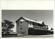
Monger St Bencubbin
Mt Marshall
Wheatbelt
Constructed from 1924 to 1968
| Type | Status | Date | Documents |
|---|---|---|---|
| (no listings) |
| Type | Status | Date | Documents |
|---|---|---|---|
| (no listings) |
| Type | Status | Date | Grading/Management | |
|---|---|---|---|---|
| Category | ||||
| Municipal Inventory | Adopted | 20 Feb 1996 | ||
Individual Building or Group
| Epoch | General | Specific |
|---|---|---|
| Original Use | EDUCATIONAL | Primary School |
| Present Use | EDUCATIONAL | Primary School |
| Type | General | Specific |
|---|---|---|
| Wall | ASBESTOS | Fibrous Cement, flat |
| Roof | METAL | Corrugated Iron |
| General | Specific |
|---|---|
| SOCIAL & CIVIC ACTIVITIES | Community services & utilities |
This information is provided voluntarily as a public service. The information provided is made available in good faith and is derived from sources believed to be reliable and accurate. However, the information is provided solely on the basis that readers will be responsible for making their own assessment of the matters discussed herein and are advised to verify all relevant representations, statements and information.
Constructed from 1924, Constructed from 1968
Earliest existing school within the shire. The second classroom addition was probably the previous Welbungin school.
long rectangular weatherboard, iron roofed building consissting of four classrooms, office, staffroom and storage areas, with verandah along north side. Separate library building is constructed from fibro-cement with iron roof.
The primary school for Bencubbin district. As the small school in the surrounding area were closed it increased in size to accommodate children from these. Contract let February 1924, completed April 11th 1924. Welbungin school added 1948, 3rd classroom 1953, ancillary room 1967 and 4th classroom added 1968.
Integrity: Intact- roof is not original. Modifications; Lining of original building and addition of three classrooms at intervals.
| Ref ID No | Ref Name | Ref Source | Ref Date |
|---|---|---|---|
| M Hardwick; "Gimlet" | 1979 |
| Owner | Category |
|---|---|
| Education Department | State Gov't |
This information is provided voluntarily as a public service. The information provided is made available in good faith and is derived from sources believed to be reliable and accurate. However, the information is provided solely on the basis that readers will be responsible for making their own assessment of the matters discussed herein and are advised to verify all relevant representations, statements and information.
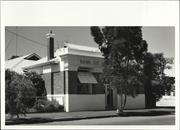
Monger St Bencubbin
Baker, Post Office
R & I Bank (fmr)
Mt Marshall
Wheatbelt
Constructed from 1923
| Type | Status | Date | Documents |
|---|---|---|---|
| (no listings) |
| Type | Status | Date | Documents |
|---|---|---|---|
| (no listings) |
| Type | Status | Date | Grading/Management | |
|---|---|---|---|---|
| Category | ||||
| Municipal Inventory | Adopted | 20 Feb 1996 | ||
| Library Id | Title | Medium | Year Of Publication |
|---|---|---|---|
| 3806 | Sandalwood Shops Bencubbin Conservation Plan | Heritage Study {Cons'n Plan} | 1998 |
Individual Building or Group
| Epoch | General | Specific |
|---|---|---|
| Original Use | INDUSTRIAL\MANUFACTURING | Bakery |
| Original Use | Transport\Communications | Comms: Post or Telegraph Office |
| Original Use | Transport\Communications | Comms: Newspaper\Publishing Bldg |
| Present Use | COMMERCIAL | Shopping Complex |
| Original Use | COMMERCIAL | Shop\Retail Store {single} |
| Original Use | COMMERCIAL | Bank |
| Type | General | Specific |
|---|---|---|
| Roof | METAL | Corrugated Iron |
| Wall | BRICK | Other Brick |
| General | Specific |
|---|---|
| OCCUPATIONS | Commercial & service industries |
This information is provided voluntarily as a public service. The information provided is made available in good faith and is derived from sources believed to be reliable and accurate. However, the information is provided solely on the basis that readers will be responsible for making their own assessment of the matters discussed herein and are advised to verify all relevant representations, statements and information.
Constructed from 1923
One of the first substantial buildings to be built in Bencubbin. Housed the first bank (West Australian bank) and post office in the Shire.
Four single storey brick shop with iron roof and verandah extending over footpath.
Integrity: Intact
Poor
| Ref ID No | Ref Name | Ref Source | Ref Date |
|---|---|---|---|
| Fh Broomehall; "Mt Marshall History". |
This information is provided voluntarily as a public service. The information provided is made available in good faith and is derived from sources believed to be reliable and accurate. However, the information is provided solely on the basis that readers will be responsible for making their own assessment of the matters discussed herein and are advised to verify all relevant representations, statements and information.
19 Monger St Bencubbin
Cnr Monger and Murray Sts
Mt Marshall
Wheatbelt
Constructed from 1922
| Type | Status | Date | Documents |
|---|---|---|---|
| (no listings) |
| Type | Status | Date | Documents |
|---|---|---|---|
| (no listings) |
| Type | Status | Date | Grading/Management | |
|---|---|---|---|---|
| Category | ||||
| Municipal Inventory | Adopted | 20 Feb 1996 | ||
Individual Building or Group
| Epoch | General | Specific |
|---|---|---|
| Present Use | RESIDENTIAL | Single storey residence |
| Original Use | RESIDENTIAL | Single storey residence |
| Type | General | Specific |
|---|---|---|
| Other | METAL | Tin |
| Roof | METAL | Corrugated Iron |
| Wall | ASBESTOS | Fibrous Cement, flat |
This information is provided voluntarily as a public service. The information provided is made available in good faith and is derived from sources believed to be reliable and accurate. However, the information is provided solely on the basis that readers will be responsible for making their own assessment of the matters discussed herein and are advised to verify all relevant representations, statements and information.
Constructed from 1922
An example of early weatherboard construction and was the residence of the local builder, plumber and "very good tradesman" and was possibly built by him. The fibro-cement section addition was the Agricultural Bank (R&I Bank), around the 1940's - anecdotal. He is mentioned in Broomhall's history of Mt Marshall as having resided at Lot 35 in 1925 and 1932. Charlie Webster built the CWA Rooms, the Roman Catholic Church and the residence for the Road Board Secretary.
An L - shaped weatherboard dwelling with iron roof. Extension of fibro-cement to right of the front door. Board floor on verandah at front and part way down one side, to the left of front door. Interior has some rooms with pressed tin ceilings and wall,s and the front fibro-cement room has interior walls of flat tin. Some doors appear to be part of original building.
Integrity: Very Little Modifications: Various at different times over 30 years.
Poor
This information is provided voluntarily as a public service. The information provided is made available in good faith and is derived from sources believed to be reliable and accurate. However, the information is provided solely on the basis that readers will be responsible for making their own assessment of the matters discussed herein and are advised to verify all relevant representations, statements and information.
43-49 Monger St Bencubbin
Mt Marshall
Wheatbelt
Constructed from 1922
| Type | Status | Date | Documents |
|---|---|---|---|
| (no listings) |
| Type | Status | Date | Documents |
|---|---|---|---|
| RHP - Does not warrant assessment | Current | 26 Nov 2010 |
| Type | Status | Date | Grading/Management | |
|---|---|---|---|---|
| Category | ||||
| Statewide Hotel Survey | Completed | 01 Nov 1997 | ||
| Municipal Inventory | Adopted | |||
Individual Building or Group
| Epoch | General | Specific |
|---|---|---|
| Present Use | COMMERCIAL | Hotel, Tavern or Inn |
| Original Use | COMMERCIAL | Hotel, Tavern or Inn |
| Type | General | Specific |
|---|---|---|
| Wall | ASBESTOS | Fibrous Cement, flat |
| Wall | BRICK | Other Brick |
| Wall | STONE | Local Stone |
| Roof | METAL | Corrugated Iron |
| General | Specific |
|---|---|
| OCCUPATIONS | Hospitality industry & tourism |
This information is provided voluntarily as a public service. The information provided is made available in good faith and is derived from sources believed to be reliable and accurate. However, the information is provided solely on the basis that readers will be responsible for making their own assessment of the matters discussed herein and are advised to verify all relevant representations, statements and information.
Constructed from 1929, Constructed from 1922
The building is one of the earliest solid construction buildings in the area and had significance as both a meeting place for residents and as a confortable place to stay for travellers.
Original building was a single storey brick with some locally quarried stone. It consisted of two bars, commercial room, several bedrooms, the usual conveniences, amnager's quarters, kitchen and dining room. At the rear were weatherboard staff quarters. 1929 additions included 20 bedrooms, 3 bathrooms and a large drawing room upstairs. Ground floor additions were a new kitchen, lounge and saloon bar. Free standing fibro cemment motel style units were added at a later date, at the rear of the two storey section.
Integrity: Most intact. Modifications: Addition of separate fibro cement motel style units at rear.
Reasonable
This information is provided voluntarily as a public service. The information provided is made available in good faith and is derived from sources believed to be reliable and accurate. However, the information is provided solely on the basis that readers will be responsible for making their own assessment of the matters discussed herein and are advised to verify all relevant representations, statements and information.
Bencubbin Hotel, Monger Street, Bencubbin has cultural heritage significance for the following reasons: It demonstrates the development and decline of rural Western Australian towns and the changing patterns and needs of commercial and leisure travellers and rural communities. It is closely associated with the Hon Edward Bertram ‘Bertie’ Johnston, former MLA for Williams Narrogin (1991-1928) and Senator for Western Australia (1929-1942), who owned the hotel, and a number of others, from the time of its construction until the end of his life in September 1942. It is closely associated with well-known Perth architect George Herbert Parry who designed the hotel and a number of others, including the Captain Stirling Hotel, which was also owned by Bertie Johnston. It forms a major landmark on Monger Street, Bencubbin and is likely to have been the only two storey commercial building constructed in the town. It is significant to the community of Bencubbin as a meeting place for residents of Bencubbin and surrounding areas and as a comfortable place to stay for travellers. ASSESSMENT OF CULTURAL HERITAGE SIGNIFICANCE Importance to the course, or pattern of our cultural or natural history: The construction and later extension of the Bencubbin Hotel reflects the development of rural Western Australian towns and the changing patterns and needs of commercial and leisure travellers. The now vacant state condition of the Bencubbin Hotel reflects the pattern of decline in rural farming and wheatbelt communities and the viability of businesses in those towns. The intention of the current owners to conserve and restore the hotel for a sustainable hospitality use reflects the significance of such buildings to the Western Australian community. Possession of uncommon, rare or endangered aspects of our cultural or natural history: The Bencubbin Hotel is likely to have been the largest, and only two storey building, in Bencubbin. Potential to yield information that will contribute to an understanding of our cultural or natural history: Importance in demonstrating the principal characteristics of a class of cultural or natural places or environments: The Bencubbin Hotel demonstrates the changing role and importance of hotels in rural and regional Western Australian towns. Importance in exhibiting particular aesthetic characteristics: The Bencubbin Hotel is a major landmark on Monger Street, Bencubbin. The Hotel appears to have been the largest and only two-storey building in Bencubbin. Importance in demonstrating a high degree of creative or technical achievement at a particular period: Strong or special association with a particular community or cultural group for social, cultural or spiritual reasons. This includes significance of a place to indigenous peoples as part of their continuing and developing cultural traditions: The Bencubbin Hotel is significant to the community of Bencubbin as a meeting place for residents of Bencubbin and surrounding areas and as a comfortable place to stay for travellers. The intention of the current owners to conserve and restore the hotel for a sustainable hospitality use reflects the significance of such buildings to the Western Australian community. Special association with the life or works of a person or groups of person, of importance in our history: The Bencubbin Hotel is closely associated with the Hon Edward Bertram Johnston, former MLA for Williams Narrogin (1991-1928) and Senator for Western Australia (1929-1942). Johnston constructed the Bencubbin Hotel and had extensive and successful business and hotel interests including the Captain Stirling Hotel, Nedlands and the Inglewood Hotel. The Bencubbin Hotel is closely associated with well-known Perth architect, George Herbert Parry who designed the original hotel and its later two storey addition. Parry was also responsible for the design, along with Marshall Clifton, of other hotels owned by Johnston, including the Captain Stirling Hotel in Nedlands and the Inglewood Hotel.
The 1997 Statewide Survey of Hotels 1829-1939 Southern Region, Western Australia describes the Bencubbin Hotel as follows: “The hotel is built on the corner of Monger Street and Padbury Street. Progressing north east along Monger Street away from the Padbury intersection are two single storey buildings followed by the two storey block. Each of these adjoining buildings are interconnected. The building nearest the intersection has a gable, corrugated iron clad, medium pitch roof with the main ridge running parallel with Monger Street and a secondary ridge carrying a gable, infilled with brick work, lining with the street wall face. A lean-to verandah roof of low pitch, supported on timber posts and separated from the main roof by a gutter line, lines the Monger Street elevation. Vented gablets spring from the body of the roof. The walls at the street elevation have a face brick dad and stucco render above. The single storey building to the west is similar with a gable roof, brick infilled gable in the line of the street wall and low pitched verandahs. The walls facing the street are of stucco render and stone work with brick quoins at the corners of the building projections. The two storey section follows the same pattern with a gabled roof with the main ridge running parallel with Monger Street and a secondary ridge carrying a gable to the gutter line of the two storey verandah which runs the width of the building. The verandah is supported on timber posts and has a sheeted balustrade at first floor level and a matching valance at ground floor level. The walls are of face brick. Behind the building are various out buildings including a row of dilapidated framed and fibro cement clad motel units.”
Assessment: 2021 Construction: 1922 Alterations/Additions: 1929 Architect/designer: George Herbert Parry The Shire of Mt Marshall’s website provides the following brief history of Bencubbin: “The land around Bencubbin was opened for selection in 1910 but the town was not gazetted until 1917, the same year the railway had reached the townsite. Prior to this time the Sandalwood pullers had been through the district and their tracks were later used for roads. Those areas that had reasonably reliable water in the form of gnamma holes or soaks, which were also used as grazing country for flocks of sheep with shepherds in the district from the late 1890s. Once the rail line came through settlement stepped up and soon there was a Post Office and other stores to service the district. Prior to this time settler travelled to Kellerberrin once or twice a year to purchase supplies. At one time Bencubbin had two general stores, fuel outlets, a butcher, baker, Post Office, Hotel and so on. As the population declined it became harder to support these businesses and slowly they have been absorbed into other businesses in town. A Police service has been present since those early days. At one time there were numerous government employees housed in Bencubbin. Railway workers, agricultural personnel, and advisors all lived and worked in the town. The social life of the community in the past centred on the dances and balls that the various organisations ran, the pictures shown in the hall by Paddy Baker and the various sports. The school has been part of community life from those very early years and continued to be an important part of the community to this day.” In 1922 Albert Johnston applied for a provisional certificate for a large hotel in Bencubbin. It is later reported that the Hotel was owned by Edward Bertram Johnston who was known as Bertie. It is likely that his name was misreported as Albert. Johnston was born in 1880 in Geraldton and became the MLA for Williams Narrogin in 1911 representing the Labor Party. He resigned in December 1915 but was re-elected in January 1916 as an Independent and became a member of the Country Party in June 1917. He remained in state politics until 1928, holding the position of Speaker briefly in 1917 and Deputy Leader of the Country Party from 1923 until 1928. In July 1929 he was elected to the Commonwealth Senate where he served until September 1942. Johnston had extensive and successful business and hotel interests, engaging Herbert Parry and Marshall Clifton to build the Captain Stirling and Inglewood Hotels in Perth. In 1942 he was accused of falsifying his income tax returns and when Parliament resumed in September he told a group of reporters and politicians that ‘you will never see me again’. He went for a swim and drowned in Port Philip Bay on 6 September 1942. A number of community members spoke in support of the Johnston’s application, agreeing that ‘a good residential hotel was Bencubbin’s most urgent need’. The proposed hotel, designed by architect G Herbert Parry, was described as ‘Dining room 34’ 6” x 18’; commercial room, 24’ x 18’; large lounge hall, 14 bedrooms, 2 bath rooms, parlours, saloon and public bars, and every modern improvement, including large sleeping out verandahs, motor garage and septic tank’. Architect George Herbert Parry (1882-1951), who always used his middle name, was born in Perth and was educated both in Perth and England. He returned to Perth in 1907 and joined the Public Works Department. The next year he joined architects MF and JC Cavanagh and in 1911 established his own practice. Parry’s father was the second Church of England Bishop in Perth and this strong connection saw him design a number of Anglican Church buildings including St Mary’s Church, South Perth; St Catherine’s, Greenough; and the Burt Memorial Hall at St George’s Cathedral. Herbert married Isla Burt in 1910. He was also responsible for numerous other non-ecclesiastical places including a number of hotels and was associated with the design of hotels in Kalamunda, Koorda and Mukinbudin as well as the Captain Stirling Hotel, Nedlands and the Inglewood Hotel. The Bencubbin Hotel opened in September 1922 ‘for the use of travellers and thirsty ones’. The proprietor was noted as Mr Grave. A Publican’s General Licence was issued to TR Polak of the Bencubbin Hotel in November 1923. Shortly after this time, newspapers refer to Fred Polak as the licensee of the hotel and in 1926 a publican’s general licence is renewed for FRL Pollack (probably a misspelling). In 1929, the hotel was owned by Senator-elect, the Hon EB Johnston. Extensions to the hotel were proposed from at least January 1929 when it was noted that works could not commence until May when it had rained and water was available. Six rooms were to be constructed at the rear of the existing hotel and which would be subsequently used for staff rooms. In March of that year it was reported that ‘Bencubbin is the outlet for an enormous area north of the Wyalkatchem – Lake Brown loop. Travellers covering this northern area make Bencubbin their base and the Hotel in consequence very often is taxed to its limit of accommodation. The extensions proposed will be double-storied and will extend west of the present building. The ground floor will include single and double bedrooms, and a new kitchen and staff dining room etc. The upper floor will be devoted to more bedrooms, and a commodious drawing room, 25 feet extend the length of the new building in front and at the rear there will be a similar balcony, eight feet wide. The total new bedrooms will be 21, providing ample accommodation for the future. Three new bathrooms and adequate other conveniences are included in the scheme. On the east side of the existing building a new saloon bar 25 feet by 33 feet wide will be built. The plans for the extensions were prepared by Mr Herbert Parry, of Perth, and tenders will be called almost immediately.’ Whilst ‘Bertie’ Johnston owned the hotel since its construction, there were was a regular changing of the guard in the hotel’s management. In 1930, Mr J Elliot, formerly of the Bencubbin Hotel, purchased the Yealering Hotel. Mr and Mrs Polak, who likely took over from Elliot, left the Bencubbin Hotel in May 1933 to take up management of another hotel. Renovations and improvements to the Bencubbin Hotel were undertaken in 1934 with the ‘newly-installed refrigerating plant in the bar…voted a real winner’. Mr and Mrs RI Nicholson had recently taken over the management of the hotel from Mr and Mrs George Chapman. Mr and Mrs V Polak took over the Bencubbin Hotel from Mr and Mrs Nicholson in July 1937 to take over a guest house in Perth. Vic Polak and his wife left the hotel in 1940 with Mr and Mrs Butler taking over the management. Other licensees and managers included: 1947 Mr and Mrs George Brown 1947 Mr and Mrs Reg Miller 1948 Mr Beaton 1954 Mr and Mrs Reg Miller returned 1964 Cornelius Van De Laar 1987 Rodney Price In July 1954 the Wheatbelt Tribune and Koorda Record noted that alterations to the Bencubbin Hotel had started. The Bencubbin Hotel was damaged during Cyclone Seroja in April 2021. Roofing materials at the north-western end of the hotel was lost and there was subsequent internal damage. Hotels in the wheatbelt and other regional and rural areas of Western Australia, have struggled to remain viable with the dwindling populations as people sold their farms, properties became larger and the number of patrons have reduced.
This information is provided voluntarily as a public service. The information provided is made available in good faith and is derived from sources believed to be reliable and accurate. However, the information is provided solely on the basis that readers will be responsible for making their own assessment of the matters discussed herein and are advised to verify all relevant representations, statements and information.
55 Monger St Bencubbin
Westpac Bank & Manager's Residence
Mt Marshall
Wheatbelt
Constructed from 1929
| Type | Status | Date | Documents |
|---|---|---|---|
| (no listings) |
| Type | Status | Date | Documents |
|---|---|---|---|
| (no listings) |
| Type | Status | Date | Grading/Management | |
|---|---|---|---|---|
| Category | ||||
| Municipal Inventory | Adopted | 20 Feb 1996 | ||
| Statewide Bank Survey | Completed | 01 Nov 1997 | ||
Individual Building or Group
| Epoch | General | Specific |
|---|---|---|
| Original Use | COMMERCIAL | Bank |
| Present Use | COMMERCIAL | Bank |
| Style |
|---|
| Inter-War Free Classical |
| Type | General | Specific |
|---|---|---|
| Roof | METAL | Corrugated Iron |
| Wall | BRICK | Other Brick |
| General | Specific |
|---|---|
| OCCUPATIONS | Commercial & service industries |
This information is provided voluntarily as a public service. The information provided is made available in good faith and is derived from sources believed to be reliable and accurate. However, the information is provided solely on the basis that readers will be responsible for making their own assessment of the matters discussed herein and are advised to verify all relevant representations, statements and information.
Constructed from 1929
First and only purpose built bank in the Shire. A substantial building in the town of Bencubbin.
Single storey brick building with iron roof. Bank premises with attached residence. Bank section consists of banking chamber, manager's office and strongroom. Residence can be accessed through manager's office, or from outside entrance and consists of lounge, dining, kitchen, plus 3 bedrooms, bathroom , toilet and laundry. It also has an enclosed verandah. There is also a brick garage and another building housing staff toilets at the rear of the block.
Integrity: Intact Modifications: Minor interior modifications of both bank and residence.
Good
This information is provided voluntarily as a public service. The information provided is made available in good faith and is derived from sources believed to be reliable and accurate. However, the information is provided solely on the basis that readers will be responsible for making their own assessment of the matters discussed herein and are advised to verify all relevant representations, statements and information.
69 & 71 Monger St Bencubbin
Mt Marshall
Wheatbelt
Constructed from 1965 to 1993
| Type | Status | Date | Documents |
|---|---|---|---|
| (no listings) |
| Type | Status | Date | Documents |
|---|---|---|---|
| (no listings) |
| Type | Status | Date | Grading/Management | |
|---|---|---|---|---|
| Category | ||||
| Municipal Inventory | Adopted | 20 Feb 1996 | ||
| Name | Type | Year From | Year To |
|---|---|---|---|
| Duncan, Stephen & Mercer | Architect | - | - |
| Colin Rule & Assoc, additions | Architect | - | - |
Individual Building or Group
| Epoch | General | Specific |
|---|---|---|
| Other Use | COMMERCIAL | Bank |
| Present Use | EDUCATIONAL | Library |
| Original Use | GOVERNMENTAL | Office or Administration Bldg |
| Present Use | EDUCATIONAL | Other |
| Present Use | GOVERNMENTAL | Office or Administration Bldg |
| Original Use | EDUCATIONAL | Library |
| Type | General | Specific |
|---|---|---|
| Roof | METAL | Corrugated Iron |
| Wall | BRICK | Other Brick |
| General | Specific |
|---|---|
| SOCIAL & CIVIC ACTIVITIES | Government & politics |
This information is provided voluntarily as a public service. The information provided is made available in good faith and is derived from sources believed to be reliable and accurate. However, the information is provided solely on the basis that readers will be responsible for making their own assessment of the matters discussed herein and are advised to verify all relevant representations, statements and information.
Constructed from 1965, Constructed from 1993
Significance as the Administration Centre for the shire and is the update of the previous small premises in the front rooms of the Shire Hall.
Rectangular brick building with flat iron roof containing the shire Offices and storeroom, archives and kitchen and toilet facilities. Also a large Council Chambers and a large separate area for the Education Resource Centre plus a small Public Library area.
Integrity: Intact Modifications: Additions
Very Good
| Name | Type | Year From | Year To |
|---|---|---|---|
| Colin Rule & Assoc, additions | Architect | - | - |
| Duncan, Stephen & Mercer | Architect | - | - |
This information is provided voluntarily as a public service. The information provided is made available in good faith and is derived from sources believed to be reliable and accurate. However, the information is provided solely on the basis that readers will be responsible for making their own assessment of the matters discussed herein and are advised to verify all relevant representations, statements and information.
82 Monger St Bencubbin
Cnr Rupe & Monger Sts
Hall, Museum & Craft Shop
Mount Marshall Shire Hall
Mt Marshall
Wheatbelt
Constructed from 1927 to 1950
| Type | Status | Date | Documents |
|---|---|---|---|
| (no listings) |
| Type | Status | Date | Documents |
|---|---|---|---|
| (no listings) |
| Type | Status | Date | Grading/Management | |
|---|---|---|---|---|
| Category | ||||
| Municipal Inventory | Adopted | 20 Feb 1996 | ||
| Register of the National Estate | Indicative Place | |||
| Name | Type | Year From | Year To |
|---|---|---|---|
| Mr Pickering | Architect | - | - |
Individual Building or Group
| Epoch | General | Specific |
|---|---|---|
| Present Use | GOVERNMENTAL | Town, Shire or District Hall |
| Original Use | GOVERNMENTAL | Office or Administration Bldg |
| Present Use | COMMERCIAL | Shop\Retail Store {single} |
| Present Use | EDUCATIONAL | Museum |
| Style |
|---|
| Inter-War Georgian Revival |
| Type | General | Specific |
|---|---|---|
| Roof | TILE | Terracotta Tile |
| Wall | BRICK | Common Brick |
| Wall | STONE | Local Stone |
| Roof | METAL | Corrugated Iron |
| Wall | CONCRETE | Reinforced Concrete |
| General | Specific |
|---|---|
| SOCIAL & CIVIC ACTIVITIES | Government & politics |
This information is provided voluntarily as a public service. The information provided is made available in good faith and is derived from sources believed to be reliable and accurate. However, the information is provided solely on the basis that readers will be responsible for making their own assessment of the matters discussed herein and are advised to verify all relevant representations, statements and information.
Constructed from 1927, Constructed from 1950
The building is the original solid constructed Road Board offices and Hall for the Mt Marshall Shire. It was the social focal point for all residents, with dances and balls, pictures and many other events being held there over the years. It was also used for Masonic Lodge meetings until they built their own hall. The Hall is now used for cabarets, theatre arts and craft market days and workshops.
The architecture is early pre-Depression, post Great War. The design was common to most Wheatbelt towns, with the Road Board Offices attached to a multi use Hall. Some early examples of stone work are evident, with excellent examples of pressed metal ceilings. Frontage has composite stone and brick walls, walls behind this are composite brick and render. Consists of entrance with Road Board office and board room off to each side, main hall with stage area and kitchen and storage room at rear. Landings and separate toilet block were added at rear after 1950.
Integrity: Most is intact Modifications: Toilets and landings added at rear - post 1950
Reasonable
| Name | Type | Year From | Year To |
|---|---|---|---|
| Mr Pickering | Architect | 1927 | - |
| Owner | Category |
|---|---|
| Shire of Mt Marshall | Local Gov't |
This information is provided voluntarily as a public service. The information provided is made available in good faith and is derived from sources believed to be reliable and accurate. However, the information is provided solely on the basis that readers will be responsible for making their own assessment of the matters discussed herein and are advised to verify all relevant representations, statements and information.
Lot 96 Monger St Bencubbin
Mt Marshall
Wheatbelt
Constructed from 1970
| Type | Status | Date | Documents |
|---|---|---|---|
| (no listings) |
| Type | Status | Date | Documents |
|---|---|---|---|
| (no listings) |
| Type | Status | Date | Grading/Management | |
|---|---|---|---|---|
| Category | ||||
| Municipal Inventory | Adopted | 20 Feb 1996 | ||
| Name | Type | Year From | Year To |
|---|---|---|---|
| John Fitzclarence | Architect | - | - |
Individual Building or Group
| Epoch | General | Specific |
|---|---|---|
| Original Use | RELIGIOUS | Church, Cathedral or Chapel |
| Present Use | RELIGIOUS | Church, Cathedral or Chapel |
| Type | General | Specific |
|---|---|---|
| Wall | TIMBER | Other Timber |
| Roof | TILE | Cement Tile |
| General | Specific |
|---|---|
| SOCIAL & CIVIC ACTIVITIES | Religion |
This information is provided voluntarily as a public service. The information provided is made available in good faith and is derived from sources believed to be reliable and accurate. However, the information is provided solely on the basis that readers will be responsible for making their own assessment of the matters discussed herein and are advised to verify all relevant representations, statements and information.
Constructed from 1970
The Seventh Day Adventist Church is strong in Mt Marshall and this is the only church built for them in the shire.
Rectangular building with high gable roof at front, for church services. Meeting room across the rear forms a T. Walls are timber framed with cream brickboard cladding, roof is dark grey cement tile. Front of the building has stained glass windows.
Integrity: Intact
Very Good
| Name | Type | Year From | Year To |
|---|---|---|---|
| John Fitzclarence | Architect | 1970 | - |
| Owner | Category |
|---|---|
| Seventh Day Adventist Church | Church Property |
This information is provided voluntarily as a public service. The information provided is made available in good faith and is derived from sources believed to be reliable and accurate. However, the information is provided solely on the basis that readers will be responsible for making their own assessment of the matters discussed herein and are advised to verify all relevant representations, statements and information.
Lot 170 Padbury St Bencubbin
Mt Marshall
Wheatbelt
Constructed from 1959
| Type | Status | Date | Documents |
|---|---|---|---|
| (no listings) |
| Type | Status | Date | Documents |
|---|---|---|---|
| (no listings) |
| Type | Status | Date | Grading/Management | |
|---|---|---|---|---|
| Category | ||||
| Municipal Inventory | Adopted | 20 Feb 1996 | ||
Individual Building or Group
| Epoch | General | Specific |
|---|---|---|
| Original Use | SOCIAL\RECREATIONAL | Masonic Hall |
| Present Use | SOCIAL\RECREATIONAL | Masonic Hall |
| Type | General | Specific |
|---|---|---|
| Wall | BRICK | Other Brick |
| Roof | METAL | Corrugated Iron |
| General | Specific |
|---|---|
| SOCIAL & CIVIC ACTIVITIES | Institutions |
This information is provided voluntarily as a public service. The information provided is made available in good faith and is derived from sources believed to be reliable and accurate. However, the information is provided solely on the basis that readers will be responsible for making their own assessment of the matters discussed herein and are advised to verify all relevant representations, statements and information.
Constructed from 1958, Constructed from 1959
Meeting place for members of the Mt Marshall Lodge No. 330 WAC built after many years of meeting in the Shire Hall.This lodge group is the only active group remaining int he Mt Marshall and adjacent shires.
Rectangular building approximate 63 m by 33m with an addition approximately 9m by 18m at one end (facing street) on the long side and toilets at the other end. Red clay brick with an iron roof, windows set high on long sides.
Integrity: Intact
Good
| Owner | Category |
|---|---|
| Mt Marshall Masonic Lodge | Inc. Non-profit body |
This information is provided voluntarily as a public service. The information provided is made available in good faith and is derived from sources believed to be reliable and accurate. However, the information is provided solely on the basis that readers will be responsible for making their own assessment of the matters discussed herein and are advised to verify all relevant representations, statements and information.
RSL Hall Bencubbin
Mt Marshall
Wheatbelt
Constructed from 1900
| Type | Status | Date | Documents |
|---|---|---|---|
| (no listings) |
| Type | Status | Date | Documents |
|---|---|---|---|
| (no listings) |
| Type | Status | Date | Grading/Management | |
|---|---|---|---|---|
| Category | ||||
| Statewide War Memorial Survey | Completed | 01 May 1996 | ||
Historic site
| Epoch | General | Specific |
|---|---|---|
| Present Use | MONUMENT\CEMETERY | Monument |
| Original Use | MONUMENT\CEMETERY | Monument |
| General | Specific |
|---|---|
| OUTSIDE INFLUENCES | World Wars & other wars |
This information is provided voluntarily as a public service. The information provided is made available in good faith and is derived from sources believed to be reliable and accurate. However, the information is provided solely on the basis that readers will be responsible for making their own assessment of the matters discussed herein and are advised to verify all relevant representations, statements and information.
S of Beacon-Kalannie Rd Cleary
Mt Marshall
Wheatbelt
| Type | Status | Date | Documents |
|---|---|---|---|
| (no listings) |
| Type | Status | Date | Documents |
|---|---|---|---|
| (no listings) |
| Type | Status | Date | Grading/Management | |
|---|---|---|---|---|
| Category | ||||
| Municipal Inventory | Adopted | 20 Feb 1996 | ||
Individual Building or Group
| Epoch | General | Specific |
|---|---|---|
| Original Use | RESIDENTIAL | Single storey residence |
| Present Use | RESIDENTIAL | Single storey residence |
| Type | General | Specific |
|---|---|---|
| Roof | METAL | Corrugated Iron |
| Wall | OTHER | Other Material |
| General | Specific |
|---|---|
| DEMOGRAPHIC SETTLEMENT & MOBILITY | Settlements |
This information is provided voluntarily as a public service. The information provided is made available in good faith and is derived from sources believed to be reliable and accurate. However, the information is provided solely on the basis that readers will be responsible for making their own assessment of the matters discussed herein and are advised to verify all relevant representations, statements and information.
A small remaining piece of the way early settlers lived when they first took up their land.
The remains of two whitewashed bag walls, with a wood stove still in place. All this is in the middle of an old shed built of timber pales and roofed with iron, the shed was used as a shearing shed while the dwelling was lived in.
Integrity: Very Little
Poor
This information is provided voluntarily as a public service. The information provided is made available in good faith and is derived from sources believed to be reliable and accurate. However, the information is provided solely on the basis that readers will be responsible for making their own assessment of the matters discussed herein and are advised to verify all relevant representations, statements and information.
S of Beacon-Kalannie Rd Cleary
Mt Marshall
Wheatbelt
| Type | Status | Date | Documents |
|---|---|---|---|
| (no listings) |
| Type | Status | Date | Documents |
|---|---|---|---|
| (no listings) |
| Type | Status | Date | Grading/Management | |
|---|---|---|---|---|
| Category | ||||
| Municipal Inventory | Adopted | 20 Feb 1996 | ||
Individual Building or Group
| Epoch | General | Specific |
|---|---|---|
| Present Use | RESIDENTIAL | Single storey residence |
| Original Use | RESIDENTIAL | Single storey residence |
| Type | General | Specific |
|---|---|---|
| Wall | BRICK | Other Brick |
| Roof | METAL | Corrugated Iron |
| General | Specific |
|---|---|
| OCCUPATIONS | Domestic activities |
This information is provided voluntarily as a public service. The information provided is made available in good faith and is derived from sources believed to be reliable and accurate. However, the information is provided solely on the basis that readers will be responsible for making their own assessment of the matters discussed herein and are advised to verify all relevant representations, statements and information.
A good example of the use of local materials to build dwellings. There are many examples if this style of building in the Mt Marshall area in various stages of repair, some homes are still occupied although updated to some degree.
Substantial dwelling built of mud brick (soil obtained from nearky), with an iron roof. Four main rooms with central hallway for access to each of these and a verandah on three sides. At rear, a storeroom, laundry and porch under a lean-to with another room extended at right angles (use unknown). A separate building beyond rear for a generating plant and a separate toilet.
Integrity: Most Modifications: Roof replacement approximately 1970's.
Poor: some walls at rear of the building are crumbling due to weathering.
This information is provided voluntarily as a public service. The information provided is made available in good faith and is derived from sources believed to be reliable and accurate. However, the information is provided solely on the basis that readers will be responsible for making their own assessment of the matters discussed herein and are advised to verify all relevant representations, statements and information.
56 Hammond Street Gabbin
Mt Marshall
Wheatbelt
Constructed from 1930
| Type | Status | Date | Documents |
|---|---|---|---|
| (no listings) |
| Type | Status | Date | Documents |
|---|---|---|---|
| RHP - To be assessed | Current | 31 Oct 2014 |
| Type | Status | Date | Grading/Management | |
|---|---|---|---|---|
| Category | ||||
| (no listings) | ||||
· The place is representative of the provision of accommodation and refreshment for the itinerant workforce in the wheatbelt during the early twentieth century, a workforce which expanded along with the expanding agricultural industry, as well as the role of women in the provision of these services to supplement household income
· The place represents the innovative and enterprising decisions taken by new immigrants to make a living in the harsh conditions of the wheatbelt during the early twentieth century · The place is testament to the enduring spirit of pioneering women in the Western Australian wheatbelt, and their capacity to make the best of the conditions they were presented with
The place is a rendered brick and iron structure with a simple lean-to verandah across the front on square timber poles. Windows are timber-framed, the majority having multiple small panes at the top. A number of doors open onto the verandah which appears to have simple gravelled/dirt flooring. No information was provided about the interior of the place in the nomination.
By the beginning of the twentieth-century Australia’s agricultural production expanded rapidly due to new and improved technology resulting in Australia becoming one of the world’s major food exporters. To support this growth, successive governments initiated assistance schemes with bonuses paid on the production of a number of agricultural products. Following the end of WWI, Australian agriculture further expanded and the ‘Government continued with its objective of establishing more of the population on the land and breaking up some of the vast 'squatter' holdings’ and ‘new areas of agriculture were established to provide returned soldiers with both a place to live and an occupation’. Unfortunately much of this latter scheme ultimately proved unsuccessful.
Poor
Individual Building or Group
| Epoch | General | Specific |
|---|---|---|
| Original Use | COMMERCIAL | Other |
| Present Use | VACANT\UNUSED | Vacant\Unused |
| Original Use | COMMERCIAL | Hotel, Tavern or Inn |
| Style |
|---|
| Vernacular |
| Type | General | Specific |
|---|---|---|
| Wall | BRICK | Common Brick |
| Roof | METAL | Corrugated Iron |
| General | Specific |
|---|---|
| PEOPLE | Local heroes & battlers |
| SOCIAL & CIVIC ACTIVITIES | Community services & utilities |
| DEMOGRAPHIC SETTLEMENT & MOBILITY | Immigration, emigration & refugees |
| TRANSPORT & COMMUNICATIONS | Rail & light rail transport |
| DEMOGRAPHIC SETTLEMENT & MOBILITY | Settlements |
| OCCUPATIONS | Hospitality industry & tourism |
This information is provided voluntarily as a public service. The information provided is made available in good faith and is derived from sources believed to be reliable and accurate. However, the information is provided solely on the basis that readers will be responsible for making their own assessment of the matters discussed herein and are advised to verify all relevant representations, statements and information.
Job Rd N of Gabbin
Near junction with Mandiga Road
Mt Marshall
Wheatbelt
Constructed from 1931
| Type | Status | Date | Documents |
|---|---|---|---|
| (no listings) |
| Type | Status | Date | Documents |
|---|---|---|---|
| RHP - Does not warrant assessment | Current | 26 Jun 2020 |
| Type | Status | Date | Grading/Management | |
|---|---|---|---|---|
| Category | ||||
| Municipal Inventory | Adopted | 20 Feb 1996 | ||
Historic site
| Epoch | General | Specific |
|---|---|---|
| Present Use | GOVERNMENTAL | Reservoir or Dam |
| Original Use | GOVERNMENTAL | Reservoir or Dam |
| Type | General | Specific |
|---|---|---|
| Roof | METAL | Corrugated Iron |
| Other | METAL | Other Metal |
| Wall | CONCRETE | Reinforced Concrete |
| General | Specific |
|---|---|
| SOCIAL & CIVIC ACTIVITIES | Community services & utilities |
This information is provided voluntarily as a public service. The information provided is made available in good faith and is derived from sources believed to be reliable and accurate. However, the information is provided solely on the basis that readers will be responsible for making their own assessment of the matters discussed herein and are advised to verify all relevant representations, statements and information.
Constructed from 1931
Gabbinning Tank and the Snake Soak Tank are situated on or near points where early explorers, sandalwooders and settlers obtained water and the building of all tanks mentioned was part of the ongoing effort to retain the small amounts of rain water that fall in the shire. Tanks of the same construction are still used at Beebeegnying, Wialki, Warkutting, Cleary, Beacon, Sand Soak and Marindo (known locally as Christe's Tank).
A round reinforced cement walled tank made by pouring the material into forms. the water is fed to the tank from a rock with retaining walls at the bottom, which then channels the water into pipes and into the tank via a header tower. The original soak which was used by explorers, sandalwooders and early settlers is nearby.
Integrity: Intact
Reasonable- leak at the base of the header.
| Owner | Category |
|---|---|
| Water Corporation | State Gov't |
This information is provided voluntarily as a public service. The information provided is made available in good faith and is derived from sources believed to be reliable and accurate. However, the information is provided solely on the basis that readers will be responsible for making their own assessment of the matters discussed herein and are advised to verify all relevant representations, statements and information.
7 Scarlett St Gabbin
Cnr Brindle & Scarlett Sts
Mt Marshall
Wheatbelt
Constructed from 1921 to 1940
| Type | Status | Date | Documents |
|---|---|---|---|
| (no listings) |
| Type | Status | Date | Documents |
|---|---|---|---|
| (no listings) |
| Type | Status | Date | Grading/Management | |
|---|---|---|---|---|
| Category | ||||
| Municipal Inventory | Adopted | 20 Feb 1996 | ||
Individual Building or Group
| Epoch | General | Specific |
|---|---|---|
| Other Use | EDUCATIONAL | Combined School |
| Present Use | SOCIAL\RECREATIONAL | Other Community Hall\Centre |
| Original Use | SOCIAL\RECREATIONAL | Other Community Hall\Centre |
| Other Use | HEALTH | Other |
| Type | General | Specific |
|---|---|---|
| Roof | METAL | Corrugated Iron |
| Wall | TIMBER | Weatherboard |
| Wall | CONCRETE | Concrete Block |
| General | Specific |
|---|---|
| SOCIAL & CIVIC ACTIVITIES | Government & politics |
This information is provided voluntarily as a public service. The information provided is made available in good faith and is derived from sources believed to be reliable and accurate. However, the information is provided solely on the basis that readers will be responsible for making their own assessment of the matters discussed herein and are advised to verify all relevant representations, statements and information.
Constructed from 1921, Constructed from 1940
The original building housed the Gabbin School in 1922, until the new school was built, and the hall was the meeting place for local residents for dances and other entertainment. Part of the original room behind the stage area was used as a Doctor's Surgery in the 1940's. In 1940 the CWA Rooms were built for meetings as a Rest Room although the Gabbin CWA was formed in 1933. The locality of Gabbin was a thriving township with a number of shops, a bank, bakery, butcher and Stock and Farm Supply Store, but the drought of 1969 saw a substantial drop in the population and therefore a lessening of the use of the services so that today there is only the Hall having very little use, the CWA still using their rooms for meetings and the school and CBH grain facility operating. The Gabbin Hall was vested in the Shire on 5th March 1952.
Original section at rear with flat iron roof and weatherboard walls attached to gable roof of the same construction weatherboard, (replaced with trimdeck in 1995). CWA rooms added to the east wall, cement block plastered walls on north, east and south walls with doors opening internally to original section, iron lean-to-roof. Interior of main hall is timber panelling on lower walls with fibrous plaster above, ceiling was burnt in the late 1970's and was not replaced, has only fish netting now to keep out leaves, board floor and raised stage area.
Integrity: Most Modifications: Replacement of w/board with trimdeck colourbond in 1995.
Poor
| Owner | Category |
|---|---|
| Shire of Mt Marshall | Local Gov't |
This information is provided voluntarily as a public service. The information provided is made available in good faith and is derived from sources believed to be reliable and accurate. However, the information is provided solely on the basis that readers will be responsible for making their own assessment of the matters discussed herein and are advised to verify all relevant representations, statements and information.
Mt Marshall
Reserve - south of Ben-Muka Road on MM Boundary Road and west of this.
Mt Marshall
Wheatbelt
Constructed from 1910, Constructed from 1911
| Type | Status | Date | Documents |
|---|---|---|---|
| (no listings) |
| Type | Status | Date | Documents |
|---|---|---|---|
| (no listings) |
| Type | Status | Date | Grading/Management | |
|---|---|---|---|---|
| Category | ||||
| Municipal Inventory | Adopted | 20 Feb 1996 | ||
Historic site
| Epoch | General | Specific |
|---|---|---|
| Present Use | GOVERNMENTAL | Other |
| Original Use | GOVERNMENTAL | Other |
| Type | General | Specific |
|---|---|---|
| Wall | STONE | Local Stone |
| General | Specific |
|---|---|
| SOCIAL & CIVIC ACTIVITIES | Community services & utilities |
This information is provided voluntarily as a public service. The information provided is made available in good faith and is derived from sources believed to be reliable and accurate. However, the information is provided solely on the basis that readers will be responsible for making their own assessment of the matters discussed herein and are advised to verify all relevant representations, statements and information.
Constructed from 1910, Constructed from 1911
Another early example of the importance of water supplies for the area and a very good example of this type of construction. Another well of the same construction but not in as good condition is the Welbungin Well built in the water course which comes from Welbungin Hill. On private property in the same area, an early farmer built several wells of this type and some of them are still in quite good condition.
Circular water storage well, built of dry rock walling on the bank of a water course. Approximately six metres deep, permanent water supply.
Integrity: Intact
Good
| Owner | Category |
|---|---|
| Water Corporation | State Gov't |
This information is provided voluntarily as a public service. The information provided is made available in good faith and is derived from sources believed to be reliable and accurate. However, the information is provided solely on the basis that readers will be responsible for making their own assessment of the matters discussed herein and are advised to verify all relevant representations, statements and information.
L side of Andrew's Tank Rd Mt Marshall
Approximately 15 kms from Bencubbin-Beacon Road.
Mt Marshall
Wheatbelt
Constructed from 1940
| Type | Status | Date | Documents |
|---|---|---|---|
| (no listings) |
| Type | Status | Date | Documents |
|---|---|---|---|
| (no listings) |
| Type | Status | Date | Grading/Management | |
|---|---|---|---|---|
| Category | ||||
| Municipal Inventory | Adopted | 20 Feb 1996 | ||
Historic site
| Epoch | General | Specific |
|---|---|---|
| Original Use | GOVERNMENTAL | Reservoir or Dam |
| Present Use | GOVERNMENTAL | Reservoir or Dam |
| Type | General | Specific |
|---|---|---|
| Roof | METAL | Corrugated Iron |
| Wall | CONCRETE | Other Concrete |
| Wall | STONE | Local Stone |
| General | Specific |
|---|---|
| SOCIAL & CIVIC ACTIVITIES | Community services & utilities |
This information is provided voluntarily as a public service. The information provided is made available in good faith and is derived from sources believed to be reliable and accurate. However, the information is provided solely on the basis that readers will be responsible for making their own assessment of the matters discussed herein and are advised to verify all relevant representations, statements and information.
Constructed from 1940
As water is a precious resource in this dry climate the catchment and retaining of water has always been an important aspect which has been addressed in various ways by the Water Authority. This tank is the only one of it's type in the shire and is therefore significant.
A large rock masonry reservoir fed by water from the larger rock higher up. The rock has a retaining wall around the bottom edge to direct the water into a cement lined sluice which then runs into the tank. A dirt bank, higher than the tank surrounds the tank on three sides.
Integrity: Mostly Intact Modifications: Earth bank around perimeter.
Reasonable: roof needs some iron replaced
| Owner | Category |
|---|---|
| Water Corporation | State Gov't |
This information is provided voluntarily as a public service. The information provided is made available in good faith and is derived from sources believed to be reliable and accurate. However, the information is provided solely on the basis that readers will be responsible for making their own assessment of the matters discussed herein and are advised to verify all relevant representations, statements and information.
Breakell Rd Mt Marshall
S of Bencubbin off the Bencubbin-Trayning Road
Mt Marshall
Wheatbelt
Constructed from 1911 to 1974
| Type | Status | Date | Documents |
|---|---|---|---|
| (no listings) |
| Type | Status | Date | Documents |
|---|---|---|---|
| (no listings) |
| Type | Status | Date | Grading/Management | |
|---|---|---|---|---|
| Category | ||||
| Municipal Inventory | Adopted | 20 Feb 1996 | ||
Other Built Type
| Epoch | General | Specific |
|---|---|---|
| Original Use | MONUMENT\CEMETERY | Grave |
| Present Use | MONUMENT\CEMETERY | Grave |
| Type | General | Specific |
|---|---|---|
| Other | METAL | Steel |
| Other | CONCRETE | Other Concrete |
| General | Specific |
|---|---|
| DEMOGRAPHIC SETTLEMENT & MOBILITY | Settlements |
This information is provided voluntarily as a public service. The information provided is made available in good faith and is derived from sources believed to be reliable and accurate. However, the information is provided solely on the basis that readers will be responsible for making their own assessment of the matters discussed herein and are advised to verify all relevant representations, statements and information.
Constructed from 1911
The grave site is significant in that Mrs Breakell was one of the first white women to live in the district. She died soon after joining her husband on the farm. The burial was on the farm because there was no cemetery in the shire at that time, Her descendants still live on the property.
Enclosure consisting of four cement corner posts with ball tops, about 1.5 m high and 25cm square. The posts ar connected by panels of link mesh wire on steel pipes. Headstone for Mrs Agnes Breakell who died on 4th November 1911, aged 48. The memorial was erected by relatives from Preston, England. Mrs Breakell's sons, Frederick Breakell (1889-1974) and Harry (Brum) Breakell (1898-1974) are also buried here.
Integrity: Intact
Reasonable
This information is provided voluntarily as a public service. The information provided is made available in good faith and is derived from sources believed to be reliable and accurate. However, the information is provided solely on the basis that readers will be responsible for making their own assessment of the matters discussed herein and are advised to verify all relevant representations, statements and information.
Off Clarke Rd Mt Marshall
Datjoin Rock N of Datjoin Well
Mt Marshall
Wheatbelt
| Type | Status | Date | Documents |
|---|---|---|---|
| (no listings) |
| Type | Status | Date | Documents |
|---|---|---|---|
| (no listings) |
| Type | Status | Date | Grading/Management | |
|---|---|---|---|---|
| Category | ||||
| Municipal Inventory | Adopted | 20 Feb 1996 | ||
Landscape
| Epoch | General | Specific |
|---|---|---|
| Present Use | OTHER | Other |
| Original Use | OTHER | Other |
| Type | General | Specific |
|---|---|---|
| Wall | OTHER | Other Material |
| General | Specific |
|---|---|
| PEOPLE | Famous & infamous people |
This information is provided voluntarily as a public service. The information provided is made available in good faith and is derived from sources believed to be reliable and accurate. However, the information is provided solely on the basis that readers will be responsible for making their own assessment of the matters discussed herein and are advised to verify all relevant representations, statements and information.
Significant for it's association with Lionel Arthur "Barney" Brockman while he evaded police in the Mt Marshall Shire May/June- September 1970..
There is only the rock overhang utilised by Barney Brockman to make a makeshift shelter for his family.
Lionel Arthur "Barney" Brockman was a parolee who spent some time evading the police in the Mt Marshall shire area in May/June to September 1970. He camped with his wife and twelve children in caves around the base if Datjoin Rock. He had various stashes of food around the area, which were stolen from local stores. He also stole vehicles in the Beacon area. In Septmeber a camp was spotted out by the emu fence. Brockman made his way back to Datjoin, which the police and helpers surrounded. When the police went in to capture him, only his wife and 10 younger children were there. Brockman and his two older sons were eventually arrested in Perejori some months later.
| Owner | Category |
|---|---|
| Water Corporation | State Gov't |
This information is provided voluntarily as a public service. The information provided is made available in good faith and is derived from sources believed to be reliable and accurate. However, the information is provided solely on the basis that readers will be responsible for making their own assessment of the matters discussed herein and are advised to verify all relevant representations, statements and information.
SW of Emu Proof Fence Mt Marshall
and some km NE of Gnargnungin Rock
Mt Marshall
Wheatbelt
| Type | Status | Date | Documents |
|---|---|---|---|
| (no listings) |
| Type | Status | Date | Documents |
|---|---|---|---|
| (no listings) |
| Type | Status | Date | Grading/Management | |
|---|---|---|---|---|
| Category | ||||
| Municipal Inventory | Adopted | 20 Feb 1996 | ||
Landscape
| Epoch | General | Specific |
|---|---|---|
| Present Use | OTHER | Other |
| Original Use | OTHER | Other |
| General | Specific |
|---|---|
| DEMOGRAPHIC SETTLEMENT & MOBILITY | Exploration & surveying |
This information is provided voluntarily as a public service. The information provided is made available in good faith and is derived from sources believed to be reliable and accurate. However, the information is provided solely on the basis that readers will be responsible for making their own assessment of the matters discussed herein and are advised to verify all relevant representations, statements and information.
Watering place recorded in the diary of John Forrest in 1869. A researcher following Forrest's expedition has positively identified this rock hole by compass readings.
Naturally occurring basin shaped depression in rock, containing water.
Integrity: Intact
Good
This information is provided voluntarily as a public service. The information provided is made available in good faith and is derived from sources believed to be reliable and accurate. However, the information is provided solely on the basis that readers will be responsible for making their own assessment of the matters discussed herein and are advised to verify all relevant representations, statements and information.