Local Government
Melville
Region
Metropolitan
4 Bombard St Ardross
Melville
Metropolitan
Constructed from 1965
| Type | Status | Date | Documents |
|---|---|---|---|
| (no listings) |
| Type | Status | Date | Documents |
|---|---|---|---|
| (no listings) |
| Type | Status | Date | Grading/Management | |
|---|---|---|---|---|
| Category | ||||
| Anglican Church Inventory | YES | 31 Jul 1996 | ||
Individual Building or Group
| Epoch | General | Specific |
|---|---|---|
| Original Use | RELIGIOUS | Church, Cathedral or Chapel |
| Present Use | RELIGIOUS | Church, Cathedral or Chapel |
| Type | General | Specific |
|---|---|---|
| Wall | BRICK | Common Brick |
| Roof | TILE | Cement Tile |
| General | Specific |
|---|---|
| SOCIAL & CIVIC ACTIVITIES | Religion |
This information is provided voluntarily as a public service. The information provided is made available in good faith and is derived from sources believed to be reliable and accurate. However, the information is provided solely on the basis that readers will be responsible for making their own assessment of the matters discussed herein and are advised to verify all relevant representations, statements and information.
Canning Hwy Ardross
REGISTERED AS PART OF 3518
Operators Building (fmr)
Melville
Metropolitan
Constructed from 1912
| Type | Status | Date | Documents |
|---|---|---|---|
| (no listings) |
| Type | Status | Date | Documents |
|---|---|---|---|
| (no listings) |
| Type | Status | Date | Grading/Management | |
|---|---|---|---|---|
| Category | ||||
| Classified by the National Trust | Classified | 03 Aug 1992 | ||
03518 Wireless Hill Park
Good.
Individual Building or Group
| Epoch | General | Specific |
|---|---|---|
| Original Use | Transport\Communications | Comms: Housing or Quarters |
| Present Use | Transport\Communications | Comms: Housing or Quarters |
| Type | General | Specific |
|---|---|---|
| Wall | BRICK | Rendered Brick |
| Roof | TILE | Other Tile |
| General | Specific |
|---|---|
| TRANSPORT & COMMUNICATIONS | Telecommunications |
This information is provided voluntarily as a public service. The information provided is made available in good faith and is derived from sources believed to be reliable and accurate. However, the information is provided solely on the basis that readers will be responsible for making their own assessment of the matters discussed herein and are advised to verify all relevant representations, statements and information.
Canning Hwy Ardross
REGISTERED AS PART OF 3518
Museum
Melville
Metropolitan
Constructed from 1912
| Type | Status | Date | Documents |
|---|---|---|---|
| (no listings) |
| Type | Status | Date | Documents |
|---|---|---|---|
| (no listings) |
| Type | Status | Date | Grading/Management | |
|---|---|---|---|---|
| Category | ||||
| Classified by the National Trust | Classified | 03 Aug 1992 | ||
03518 Wireless Hill Park
Individual Building or Group
| Epoch | General | Specific |
|---|---|---|
| Present Use | EDUCATIONAL | Museum |
| Original Use | Transport\Communications | Rail: Office or Administration Bldg |
This information is provided voluntarily as a public service. The information provided is made available in good faith and is derived from sources believed to be reliable and accurate. However, the information is provided solely on the basis that readers will be responsible for making their own assessment of the matters discussed herein and are advised to verify all relevant representations, statements and information.
Canning Hwy Ardross
REGISTERED AS PART OF 3518
SES Post and Boardroom
Melville
Metropolitan
Constructed from 1912
| Type | Status | Date | Documents |
|---|---|---|---|
| (no listings) |
| Type | Status | Date | Documents |
|---|---|---|---|
| (no listings) |
| Type | Status | Date | Grading/Management | |
|---|---|---|---|---|
| Category | ||||
| (no listings) | ||||
03518 Wireless Hill Park
Individual Building or Group
| Epoch | General | Specific |
|---|---|---|
| Original Use | GOVERNMENTAL | Other |
| Present Use | Transport\Communications | Rail: Office or Administration Bldg |
This information is provided voluntarily as a public service. The information provided is made available in good faith and is derived from sources believed to be reliable and accurate. However, the information is provided solely on the basis that readers will be responsible for making their own assessment of the matters discussed herein and are advised to verify all relevant representations, statements and information.
Canning Hwy Ardross
Melville
Metropolitan
Constructed from 1912
| Type | Status | Date | Documents |
|---|---|---|---|
| (no listings) |
| Type | Status | Date | Documents |
|---|---|---|---|
| (no listings) |
| Type | Status | Date | Grading/Management | |
|---|---|---|---|---|
| Category | ||||
| (no listings) | ||||
03823 Wireless Hill Park Museum Group
Individual Building or Group
This information is provided voluntarily as a public service. The information provided is made available in good faith and is derived from sources believed to be reliable and accurate. However, the information is provided solely on the basis that readers will be responsible for making their own assessment of the matters discussed herein and are advised to verify all relevant representations, statements and information.
Canning Hwy Ardross
Bounded clockwise by Cunningham & Hickey Sts, McCallum Cres, Davy St, Barnard St & Canning Hwy
Melville
Metropolitan
Constructed from 1912
| Type | Status | Date | Documents |
|---|---|---|---|
| Heritage List | Adopted | 16 Jun 2020 | |
| State Register | Registered | 02 Sep 1997 | HCWebsite.Listing+ListingDocument, HCWebsite.Listing+ListingDocument |
| Type | Status | Date | Documents |
|---|---|---|---|
| (no listings) |
| Type | Status | Date | Grading/Management | |
|---|---|---|---|---|
| Category | ||||
| Art Deco Significant Bldg Survey | Completed | 30 Jun 1994 | ||
| Register of the National Estate | Indicative Place | |||
| Municipal Inventory | Adopted | 17 Jun 2014 | Category A | |
| Name | Type | Year From | Year To |
|---|---|---|---|
| Hillson Beasley. | Architect | - | - |
| Library Id | Title | Medium | Year Of Publication |
|---|---|---|---|
| 3879 | Applecross Wireless Station Wireless Hill Park Ardross Conservation Plan Part 2 | Heritage Study {Cons'n Plan} | 1999 |
| 3878 | Applecross Wireless Station Wireless Hill Park Ardross Conservation Plan | Heritage Study {Cons'n Plan} | 1999 |
| 7016 | Operator's House (fmr), Applecross Wireless Station (fmr) : schedule of maintenance works. | Heritage Study {Other} | 2003 |
Urban Park
| Epoch | General | Specific |
|---|---|---|
| Original Use | Transport\Communications | Comms: Other |
| Present Use | PARK\RESERVE | Park\Reserve |
| Style |
|---|
| Other Style |
| Type | General | Specific |
|---|---|---|
| Wall | BRICK | Common Brick |
| Wall | TILE | Other Tile |
| General | Specific |
|---|---|
| TRANSPORT & COMMUNICATIONS | Telecommunications |
This information is provided voluntarily as a public service. The information provided is made available in good faith and is derived from sources believed to be reliable and accurate. However, the information is provided solely on the basis that readers will be responsible for making their own assessment of the matters discussed herein and are advised to verify all relevant representations, statements and information.
Constructed from 1912
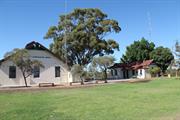
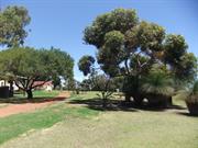
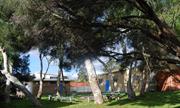
The Wireless Hill Reserve is significant on the following grounds: Aesthetic Value: The reserve is the only remaining large area of natural bushland close to the south side of the river. Historic Value: The buildings in the reserve are all linked to the operation of the now defunct Wireless Station. Social value: The reserve enhances the quality of life for the residents of Melville and it's visitors. Rarity Value: The reserve is the only remaining large area of natural bushland close to the south side of the river. Wireless Hill Park, comprising brick and tile radio operations buildings, brick and tile staff accommodation buildings, concrete tower bases, culturally modified landscape settings and urban bushland, has cultural heritage significance for the following reasons: Radio telecommunications provided one of the important links between Australia and the rest of the world at a time when these links were significant to a relatively small community in one of the most remote cities in the world; the radio communications station has played a part in the development of commercial radio broadcasting and experimental shortwave radio as well as functioning as a communications vehicle for state government instrumentalities and marine safety; it once contained all the elements of a working radio communications station from the nascent development to eventual phasing out; the place retains sufficient 1912 fabric to remain a fine example of an early radio communications station; the place was one of five main radio telecommunication stations in Australia participating in international, national, State-wide and regional radio communications and broadcasting; the mast is remembered as a highly visible and prominent landmark both by day and with its lighting at night, until decommissioned; today, the park forms the basis of a highly valued area of urban bushland.
The reserve consists of a large tract of native bushland, the original wireless station buildings remain and a network of walking paths have been established. Wireless Hill Park comprises a 41 hectare site as a landmark site of high ground, predominantly natural Banksia and jarrah woodland, with the former Wire Station Operations buildings and structures extant on the high ground of the site, including a macadamised roadway connecting the Station to four former staff houses on the low side of the site at the northwest side. The original 112 metre tall mast and guys have been removed. The anchor blocks at the base of the mast and the three anchor blocks for the guys survive, two converted to viewing platforms. Mature introduced landscape and grassed areas, car parking, access roadway and public amenities have been introduced in the vicinity of the former Station, now converted for use as a Museum of Telecommunications and associated community facilities. Interpretive material relating to the flora and fauna of the natural bushland and of the former use of the place as a Telecommunications Station, have been introduced for public education and recreation. SIGNIFICANT ITEMS: The natural bushland; the introduced mature eucalypt tree at the west side of the Museum building; the surviving structures from the former Wireless Station: - the former Operations building – now the Caretaker's Residence - the former Engine House – now the Museum - the former Store – now toilets and Meeting Room - three concrete and masonry anchor blocks, to-date two converted to viewing platforms - three concrete anchor blocks at the base of the former mast - four former staff houses at Nos. 2, 4, 6 and 8 Hickey Street - small toilet block - the macadamised roadway from the former Operations building down to the former staff houses; Heritage Trails; and interpretive material in the locality of the bushland and the former Operations building.
The Aboriginal name for Wireless Hill is ‘Yagan’s Lookout’ and has always been a significant place for communication by the Beeliar Nyoongars . Fires were used for communication, one example was signalling the movement of fish along the Swan River. Wireless Hill was a food gathering area, as well as gathering medicinal plants by the women. Telecommunication has been defined as the transmission of data-carrying signals between two points, including telegraphy, radio, telephone, television, computer networks and satellite systems. In 1912, the Federal Government built the Wireless Hill Station, one of Australia's first telecommunication stations, using Morse Code to communicate with ships off the Australian coast using a mast 112 metres tall. Known as Perth Wireless Station, the Wireless Hill Station played an important role in both World Wars, relaying messages from ship to shore. Amalgamated Wireless Australasia took over the Station in 1922, installing at that time equipment capable of monitoring signals worldwide. In 1947, Overseas Telecommunications Commission took over the Station. The Station became part of a network controlling all of Australia's external communications. The original buildings were retained following decommissioning in 1967 and closure in 1968 when the Station was vacated and the land vested in the City of Melville as a public reserve and museum of telecommunications. The original generator room was adapted as a museum, the three anchor blocks to steady the 112 metre high aerial are currently in process of conversion as viewing platforms – one block remains to be completed. Staff houses on the site were restored for ongoing residential and special community use. The site has been converted to a public park, retaining the substantial original 41 hectares of Banksia and jarrah natural bushland on the site, with grassed and landscaped areas including carparks and access roads on top of the hill around the original Station buildings. The Museum Collection is a nationally significant collection of telecommunications equipment. Community facilities have been incorporated into the parkland adjacent to and within the original buildings. The paved roadway connecting the Station down the hill to the staff houses survives, in a deteriorated condition of original fabric that is currently the focus of restoration. Professionally prepared interpretation material is located sensitively around the site to explain the significance of the natural bushland, its flora and fauna, and the original functions of the Wireless Hill Station.
Extent of Original Fabric: The reserve remains in it's original bushland form, a management strategy has been prepared to protect and maintain the reserve.
Good
| Name | Type | Year From | Year To |
|---|---|---|---|
| Hillson Beasley (PWD) | Architect | 1912 | - |
| Ref ID No | Ref Name | Ref Source | Ref Date |
|---|---|---|---|
| interpretive material on site, and pamphlets | City of Melville | ||
| Kelly Aris, Helen Burgess and Gaye Nayton;Conservation Plan Applecross Wireless Station (fmr), Wireless Hill Park, Ardross' | City of Melville | 1999 | |
| HGM Report 'Conservation and Upgrading' | May 2001 | ||
| State Register of Heritage Places Assessment documentation for Place No. 03518 'Wireless Hill Park' | Heritage Council of Western Australia | 2 September 19997. |
| Owner | Category |
|---|---|
| City of Melville | Local Gov't |
This information is provided voluntarily as a public service. The information provided is made available in good faith and is derived from sources believed to be reliable and accurate. However, the information is provided solely on the basis that readers will be responsible for making their own assessment of the matters discussed herein and are advised to verify all relevant representations, statements and information.
Canning Hwy Ardross
Bounded clockwise by Cunningham & Hickey Sts, McCallum Cres, Davy St, Barnard St & Canning Hwy REGISTERED AS PART OF 3518
Telecommunication Station (fmr)
Melville
Metropolitan
Constructed from 1912
| Type | Status | Date | Documents |
|---|---|---|---|
| (no listings) |
| Type | Status | Date | Documents |
|---|---|---|---|
| (no listings) |
| Type | Status | Date | Grading/Management | |
|---|---|---|---|---|
| Category | ||||
| Classified by the National Trust | Classified | 03 Aug 1992 | ||
| Classified by the National Trust | Classified {Lscpe} | |||
03518 Wireless Hill Park
Very good.
Individual Building or Group
| Epoch | General | Specific |
|---|---|---|
| Original Use | Transport\Communications | Comms: Other |
| Present Use | EDUCATIONAL | Museum |
| Type | General | Specific |
|---|---|---|
| Roof | TILE | Other Tile |
| Wall | BRICK | Painted Brick |
| General | Specific |
|---|---|
| SOCIAL & CIVIC ACTIVITIES | Sport, recreation & entertainment |
| TRANSPORT & COMMUNICATIONS | Telecommunications |
This information is provided voluntarily as a public service. The information provided is made available in good faith and is derived from sources believed to be reliable and accurate. However, the information is provided solely on the basis that readers will be responsible for making their own assessment of the matters discussed herein and are advised to verify all relevant representations, statements and information.
Canning Hwy Ardross
REGISTERED AS PART OF 3518
Lookout Tower
Melville
Metropolitan
Constructed from 1912
| Type | Status | Date | Documents |
|---|---|---|---|
| (no listings) |
| Type | Status | Date | Documents |
|---|---|---|---|
| (no listings) |
| Type | Status | Date | Grading/Management | |
|---|---|---|---|---|
| Category | ||||
| (no listings) | ||||
03518 Wireless Hill Park
| Library Id | Title | Medium | Year Of Publication |
|---|---|---|---|
| 7835 | A history of Wireless Hill, Melville, 1912-1967. | Heritage Study {Other} | 1993 |
Historic site
| Epoch | General | Specific |
|---|---|---|
| Original Use | Transport\Communications | Comms: Other |
| Present Use | Transport\Communications | Comms: Other |
This information is provided voluntarily as a public service. The information provided is made available in good faith and is derived from sources believed to be reliable and accurate. However, the information is provided solely on the basis that readers will be responsible for making their own assessment of the matters discussed herein and are advised to verify all relevant representations, statements and information.
Fraser Rd Ardross
Fraser Road, Point Dundas
Melville
Metropolitan
Constructed from 1897
| Type | Status | Date | Documents |
|---|---|---|---|
| (no listings) |
| Type | Status | Date | Documents |
|---|---|---|---|
| (no listings) |
| Type | Status | Date | Grading/Management | |
|---|---|---|---|---|
| Category | ||||
| (no listings) | ||||
06054 Point Dundas, Majestic Hotel Site, Boardwalk and Applecross Jetty
Historic Site
| Epoch | General | Specific |
|---|---|---|
| Other Use | COMMERCIAL | Hotel, Tavern or Inn |
| Original Use | RESIDENTIAL | Other |
| Present Use | COMMERCIAL | Hotel, Tavern or Inn |
| General | Specific |
|---|---|
| SOCIAL & CIVIC ACTIVITIES | Sport, recreation & entertainment |
This information is provided voluntarily as a public service. The information provided is made available in good faith and is derived from sources believed to be reliable and accurate. However, the information is provided solely on the basis that readers will be responsible for making their own assessment of the matters discussed herein and are advised to verify all relevant representations, statements and information.
2 Hickey St Ardross
REGISTERED AS PART OF 3518
Melville
Metropolitan
Constructed from 1912
| Type | Status | Date | Documents |
|---|---|---|---|
| (no listings) |
| Type | Status | Date | Documents |
|---|---|---|---|
| (no listings) |
| Type | Status | Date | Grading/Management | |
|---|---|---|---|---|
| Category | ||||
| (no listings) | ||||
03518 Wireless Hill Park
Very Good.
| Library Id | Title | Medium | Year Of Publication |
|---|---|---|---|
| 7835 | A history of Wireless Hill, Melville, 1912-1967. | Heritage Study {Other} | 1993 |
Individual Building or Group
| Epoch | General | Specific |
|---|---|---|
| Present Use | RESIDENTIAL | Single storey residence |
| Original Use | Transport\Communications | Comms: Housing or Quarters |
| Type | General | Specific |
|---|---|---|
| Wall | BRICK | Common Brick |
| Roof | TILE | Other Tile |
| General | Specific |
|---|---|
| TRANSPORT & COMMUNICATIONS | Telecommunications |
This information is provided voluntarily as a public service. The information provided is made available in good faith and is derived from sources believed to be reliable and accurate. However, the information is provided solely on the basis that readers will be responsible for making their own assessment of the matters discussed herein and are advised to verify all relevant representations, statements and information.
4 Hickey St Ardross
REGISTERED AS PART OF 3518
Melville
Metropolitan
Constructed from 1912
| Type | Status | Date | Documents |
|---|---|---|---|
| (no listings) |
| Type | Status | Date | Documents |
|---|---|---|---|
| (no listings) |
| Type | Status | Date | Grading/Management | |
|---|---|---|---|---|
| Category | ||||
| (no listings) | ||||
03518 Wireless Hill Park
Good.
| Library Id | Title | Medium | Year Of Publication |
|---|---|---|---|
| 7835 | A history of Wireless Hill, Melville, 1912-1967. | Heritage Study {Other} | 1993 |
Individual Building or Group
| Epoch | General | Specific |
|---|---|---|
| Present Use | RESIDENTIAL | Single storey residence |
| Original Use | Transport\Communications | Comms: Housing or Quarters |
| Type | General | Specific |
|---|---|---|
| Wall | BRICK | Common Brick |
| Roof | TILE | Other Tile |
| General | Specific |
|---|---|
| TRANSPORT & COMMUNICATIONS | Telecommunications |
This information is provided voluntarily as a public service. The information provided is made available in good faith and is derived from sources believed to be reliable and accurate. However, the information is provided solely on the basis that readers will be responsible for making their own assessment of the matters discussed herein and are advised to verify all relevant representations, statements and information.
6 Hickey St Ardross
REGISTERED AS PART OF 3518
Melville
Metropolitan
Constructed from 1912
| Type | Status | Date | Documents |
|---|---|---|---|
| (no listings) |
| Type | Status | Date | Documents |
|---|---|---|---|
| (no listings) |
| Type | Status | Date | Grading/Management | |
|---|---|---|---|---|
| Category | ||||
| (no listings) | ||||
03518 Wireless Hill Park
Good.
| Library Id | Title | Medium | Year Of Publication |
|---|---|---|---|
| 7835 | A history of Wireless Hill, Melville, 1912-1967. | Heritage Study {Other} | 1993 |
Individual Building or Group
| Epoch | General | Specific |
|---|---|---|
| Original Use | Transport\Communications | Comms: Housing or Quarters |
| Present Use | SOCIAL\RECREATIONAL | Other Community Hall\Centre |
| Type | General | Specific |
|---|---|---|
| Wall | BRICK | Common Brick |
| Roof | TILE | Other Tile |
| General | Specific |
|---|---|
| TRANSPORT & COMMUNICATIONS | Telecommunications |
This information is provided voluntarily as a public service. The information provided is made available in good faith and is derived from sources believed to be reliable and accurate. However, the information is provided solely on the basis that readers will be responsible for making their own assessment of the matters discussed herein and are advised to verify all relevant representations, statements and information.
8 Hickey St Ardross
REGISTERED AS PART OF 3518
Melville
Metropolitan
Constructed from 1912
| Type | Status | Date | Documents |
|---|---|---|---|
| (no listings) |
| Type | Status | Date | Documents |
|---|---|---|---|
| (no listings) |
| Type | Status | Date | Grading/Management | |
|---|---|---|---|---|
| Category | ||||
| (no listings) | ||||
03518 Wireless Hill Park
Very good.
| Library Id | Title | Medium | Year Of Publication |
|---|---|---|---|
| 7835 | A history of Wireless Hill, Melville, 1912-1967. | Heritage Study {Other} | 1993 |
Individual Building or Group
| Epoch | General | Specific |
|---|---|---|
| Present Use | RESIDENTIAL | Single storey residence |
| Original Use | Transport\Communications | Comms: Housing or Quarters |
| Type | General | Specific |
|---|---|---|
| Roof | TILE | Other Tile |
| Wall | BRICK | Common Brick |
| General | Specific |
|---|---|
| TRANSPORT & COMMUNICATIONS | Telecommunications |
This information is provided voluntarily as a public service. The information provided is made available in good faith and is derived from sources believed to be reliable and accurate. However, the information is provided solely on the basis that readers will be responsible for making their own assessment of the matters discussed herein and are advised to verify all relevant representations, statements and information.
30 Links Rd Ardross
Melville
Metropolitan
Constructed from 1958
| Type | Status | Date | Documents |
|---|---|---|---|
| (no listings) |
| Type | Status | Date | Documents |
|---|---|---|---|
| RHP - Assessed - Consultation (Preliminary) | Current | 30 Apr 2010 |
| Type | Status | Date | Grading/Management | |
|---|---|---|---|---|
| Category | ||||
| Municipal Inventory | Adopted | 17 Jun 2014 | Category A | |
The school is a good representative example of the secondary schools built in Western Australia during the early post World War Two period following the introduction of the Education Department's 'Co-educational Comprehensive Community High Schools' policy and subsequent changes in response to Education Department policy.
The school complex contains containing a two storey linear plan Main School Building (1957) designed in the Post-War International style, together with later additions including the Swimming Pool (1963), the Science Block (1965), Manual Arts Block (1961), Gymnasium (1969), Prevocational Centre (1969), Library (1971), the Art Building (1987) and the Performing Arts Centre (1991). The school includes a well-resolved set of Post War International style buildings in a well kept landscape setting;
Applecross Senior High School was constructed from 1957 by the Department of Education in response to dramatic population growth following World War II and the increased enrolment in Metropolitan High Schools during this period. Applecross was one of the first in a new program of High Schools to be constructed in the Metropolitan region from 1954.
| Name | Type | Year From | Year To |
|---|---|---|---|
| John Oldham - landscaping | Architect | - | - |
| Pubic Works Department | Architect | - | - |
| Library Id | Title | Medium | Year Of Publication |
|---|---|---|---|
| 9624 | Applecross Senior High School conservation plan DRAFT. | Heritage Study {Cons'n Plan} | 2010 |
| 9748 | Applecross Senior High School, Links Road, Ardross. Photographic Archive Record. | Archival Record | 2011 |
Individual Building or Group
| Epoch | General | Specific |
|---|---|---|
| Present Use | EDUCATIONAL | Secondary School |
| Original Use | EDUCATIONAL | Secondary School |
| Style |
|---|
| Post-War International |
| Type | General | Specific |
|---|---|---|
| Wall | METAL | Steel |
| Wall | METAL | Aluminium |
| Roof | METAL | Other Metal |
| Other | CONCRETE | Other Concrete |
| General | Specific |
|---|---|
| SOCIAL & CIVIC ACTIVITIES | Education & science |
This information is provided voluntarily as a public service. The information provided is made available in good faith and is derived from sources believed to be reliable and accurate. However, the information is provided solely on the basis that readers will be responsible for making their own assessment of the matters discussed herein and are advised to verify all relevant representations, statements and information.
Constructed from 1957, Constructed from 1991
The elements of cultural heritage significance are identified as the site (the location of the first Government high school in the district), the landscape as open space, and the open spaces accessible to the community. The buildings, although representative, are disparate in architectural design and not assessed to have relevant heritage value. Other high schools exist to justify entry onto the State Register of Heritage Places.
The site comprises a disparate collection of school buildings, landscape and grassed open spaces and playing fields.
Applecross Senior High School was established on the site in Ardross in 1958, much extended later from the initial post World War Two period to the 1990s, to accommodate changes in educational policy and practice by the State Government education authority. High schools had been constructed in the 1950s at Midland Junction, Mount Lawley, Armadale and Fremantle prior to the Applecross High School and its contemporaries at Hollywood and Kwinana. Applecross was developed and subdivided for residential building in the period 1890s to 1910s – intended as a 'model suburb for wealthy residents'. Development was slow, impacted by World War One and the Depression. Following World War Two, War-service housing development was introduced into the locality, increasing the resident population and the demand for new schools. The first section of Applecross Senior High School was occupied for teaching in 1958. Since that beginning, considerable additions, alterations and new built elements have been introduced onto the campus, including library, swimming pool, Science block, Manual Arts, gymnasium, prevocational centre, Performing Arts and Crafts. Applecross Senior High School attained the status of a representative, but not unique, Government high school. Some only public use of the amenities currently takes place out of school hours.
Buildings – some deterioration Landscape and site – sound.
| Name | Type | Year From | Year To |
|---|---|---|---|
| Pubic Works Department | Architect | - | - |
| John Oldham - landscaping | Architect | - | - |
This information is provided voluntarily as a public service. The information provided is made available in good faith and is derived from sources believed to be reliable and accurate. However, the information is provided solely on the basis that readers will be responsible for making their own assessment of the matters discussed herein and are advised to verify all relevant representations, statements and information.
41A McCallum Cr Ardross
Melville
Metropolitan
Constructed from 1953
| Type | Status | Date | Documents |
|---|---|---|---|
| (no listings) |
| Type | Status | Date | Documents |
|---|---|---|---|
| RHP - Does not warrant assessment | Current | 28 Feb 2014 |
| Type | Status | Date | Grading/Management | |
|---|---|---|---|---|
| Category | ||||
| (no listings) | ||||
• Baden Powell Reserve is associated with Surveyors Percy Hope and Carl Klem and their work on the Garden City principles in Perth.
• Baden Powell Reserve has been associated with the activities of the Scouting movement (and associated organisations) for over sixty years. Over that time it has maintained its status as a camping area for children and young people in an increasingly urban setting.
• The layout of the site, incorporating the campfire as the centre of the reserve, is evocative of the importance of camping and outdoor activities to the Scouts, Venturers and Rovers organisations.
• The place provides an important space for community activities for a range of groups within the City of Melville, including dog walkers and locals, and sporting and other community groups such as the Scouts, Guides, Venturers and Rovers, and contributes to the local community’s sense of place
• The place has some aesthetic value as a reserve, campsite and bird habitat within the surrounding urban environment.
The place is an internal reserve-community space at the rear of residential lots with no street frontage encompassing an area of approximately 4,797 square metres. The lot includes two narrow access laneways that extend from Collier Street and McCallum Crescent in the western and eastern corners of the block.
Archaeological evidence suggests Aboriginal people have occupied Australia for at least 65,000 years. Aboriginal people believe the connection is much longer. The City of Melville is located within the Aboriginal cultural region of Beeliar for the Whadjuk Noongar people, which remained undisrupted until 1829, with the arrival of colonists in Fremantle and the establishment of the Swan River Colony.
Urban Open Space
| Epoch | General | Specific |
|---|---|---|
| Present Use | SOCIAL\RECREATIONAL | Other Community Hall\Centre |
| Original Use | SOCIAL\RECREATIONAL | Other Community Hall\Centre |
| General | Specific |
|---|---|
| SOCIAL & CIVIC ACTIVITIES | Community services & utilities |
This information is provided voluntarily as a public service. The information provided is made available in good faith and is derived from sources believed to be reliable and accurate. However, the information is provided solely on the basis that readers will be responsible for making their own assessment of the matters discussed herein and are advised to verify all relevant representations, statements and information.
2 Mitchell St Ardross
Melville
Metropolitan
Constructed from 1950
| Type | Status | Date | Documents |
|---|---|---|---|
| (no listings) |
| Type | Status | Date | Documents |
|---|---|---|---|
| (no listings) |
| Type | Status | Date | Grading/Management | |
|---|---|---|---|---|
| Category | ||||
| Anglican Church Inventory | YES | 31 Jul 1996 | ||
Individual Building or Group
| Epoch | General | Specific |
|---|---|---|
| Present Use | RELIGIOUS | Housing or Quarters |
| Original Use | RELIGIOUS | Housing or Quarters |
| Type | General | Specific |
|---|---|---|
| Wall | BRICK | Common Brick |
| Roof | TILE | Cement Tile |
| General | Specific |
|---|---|
| SOCIAL & CIVIC ACTIVITIES | Religion |
This information is provided voluntarily as a public service. The information provided is made available in good faith and is derived from sources believed to be reliable and accurate. However, the information is provided solely on the basis that readers will be responsible for making their own assessment of the matters discussed herein and are advised to verify all relevant representations, statements and information.
3 Mitchell St Ardross
Melville
Metropolitan
Constructed from 1950
| Type | Status | Date | Documents |
|---|---|---|---|
| (no listings) |
| Type | Status | Date | Documents |
|---|---|---|---|
| (no listings) |
| Type | Status | Date | Grading/Management | |
|---|---|---|---|---|
| Category | ||||
| Anglican Church Inventory | YES | 31 Jul 1996 | ||
Individual Building or Group
| Epoch | General | Specific |
|---|---|---|
| Original Use | RELIGIOUS | Office or Administration Bldg |
| Present Use | RELIGIOUS | Office or Administration Bldg |
| Type | General | Specific |
|---|---|---|
| Roof | TILE | Cement Tile |
| Wall | BRICK | Common Brick |
| General | Specific |
|---|---|
| SOCIAL & CIVIC ACTIVITIES | Religion |
This information is provided voluntarily as a public service. The information provided is made available in good faith and is derived from sources believed to be reliable and accurate. However, the information is provided solely on the basis that readers will be responsible for making their own assessment of the matters discussed herein and are advised to verify all relevant representations, statements and information.
Wireless Hill Ardross
Melville
Metropolitan
Constructed from 1969
| Type | Status | Date | Documents |
|---|---|---|---|
| (no listings) |
| Type | Status | Date | Documents |
|---|---|---|---|
| (no listings) |
| Type | Status | Date | Grading/Management | |
|---|---|---|---|---|
| Category | ||||
| (no listings) | ||||
03518 Wireless Hill Park
Good.
Landscape
| Epoch | General | Specific |
|---|---|---|
| Original Use | SOCIAL\RECREATIONAL | Other |
| Present Use | SOCIAL\RECREATIONAL | Other |
| General | Specific |
|---|---|
| SOCIAL & CIVIC ACTIVITIES | Sport, recreation & entertainment |
| SOCIAL & CIVIC ACTIVITIES | Education & science |
This information is provided voluntarily as a public service. The information provided is made available in good faith and is derived from sources believed to be reliable and accurate. However, the information is provided solely on the basis that readers will be responsible for making their own assessment of the matters discussed herein and are advised to verify all relevant representations, statements and information.
568 Canning Hwy Attadale
PIN NO. (Landgate): 231155 Lot 62, Diagram 59333 Certificate of Title Volume 1581 Folio 755
Melville
Metropolitan
| Type | Status | Date | Documents |
|---|---|---|---|
| (no listings) |
| Type | Status | Date | Documents |
|---|---|---|---|
| (no listings) |
| Type | Status | Date | Grading/Management | |
|---|---|---|---|---|
| Category | ||||
| (no listings) | ||||
Individual Building or Group
This information is provided voluntarily as a public service. The information provided is made available in good faith and is derived from sources believed to be reliable and accurate. However, the information is provided solely on the basis that readers will be responsible for making their own assessment of the matters discussed herein and are advised to verify all relevant representations, statements and information.
Constructed from 1919
The House is important as the residence of Alfred Groves, dairy farmer and early settler in the district, and as a significant example of a large Federation style house formerly part of an extensive dairy farm.
A single-storey brick and tile house, set back from the street boundary with expansive timber-framed verandahs, high-pitched roof and tall chimneys; the former landscaped grounds are now brick-paved for onsite car parking.
Alfred Groves, dairy farmer and early settler in the locality, constructed the house on an 11 hectare property supplemented with leased properties along the foreshore of the Canning River. The house has changed in use and is now separated from the former rural land by subdivision and residential development.
Sound
This information is provided voluntarily as a public service. The information provided is made available in good faith and is derived from sources believed to be reliable and accurate. However, the information is provided solely on the basis that readers will be responsible for making their own assessment of the matters discussed herein and are advised to verify all relevant representations, statements and information.
12-38 Moreing Rd Attadale
Melville
Metropolitan
Constructed from 1938, Constructed from 1958
| Type | Status | Date | Documents |
|---|---|---|---|
| Heritage List | Adopted | 16 Jun 2020 |
| Type | Status | Date | Documents |
|---|---|---|---|
| RHP - To be assessed | Current | 28 Nov 2008 |
| Type | Status | Date | Grading/Management | |
|---|---|---|---|---|
| Category | ||||
| Municipal Inventory | Adopted | 17 Jun 2014 | Category A | |
The place is a fine example of the Inter-war Spanish Mission style in Western Australia. The place has high integrity because it has continuously housed the school’s administration. The place contributes to the history of the Sisters of Mercy and Catholic education in Western Australia at a time when metropolitan boarding facilities for country children were in high demand by rural Catholic families. The place has associations with wartime activity in Perth.
The place comprises the original school building (1938) which housed staff and borders’ quarters, school rooms and administrative centre; and chapel which was added in 1956. It is a large, three-storey, rectangular structure, displaying the Inter-war Spanish Mission style, with elements of the Inter-war Mediterranean style. The walls are constructed of brick with cement render. Round arches are used on the ground floor veranda and middle floor balcony. The roof is tiled with a medium to low pitch, with a bell tower. The chapel is attached to the administration building and has been constructed in the same Inter-war Spanish Mission style. The place is sited amongst a group of school buildings, landscaped gardens and playing fields.
In 1831, the Sisters of Mercy were founded in Dublin, Ireland, by Catherine McAuley. In 1846, the first group of sisters, led by Ursula Frayne, came from Dublin and settled in Victoria Square, Perth. The Sisters of Mercy began establishing and providing Catholic education in Perth.
| Name | Type | Year From | Year To |
|---|---|---|---|
| Edgar le B Henderson | Architect | 1938 | - |
Individual Building or Group
| Epoch | General | Specific |
|---|---|---|
| Original Use | EDUCATIONAL | Office or Administration Bldg |
| Present Use | EDUCATIONAL | Office or Administration Bldg |
| Original Use | EDUCATIONAL | Combined School |
| Style |
|---|
| Inter-War Mediterranean |
| Inter-War Spanish Mission |
| Type | General | Specific |
|---|---|---|
| Wall | BRICK | Rendered Brick |
| General | Specific |
|---|---|
| SOCIAL & CIVIC ACTIVITIES | Education & science |
| SOCIAL & CIVIC ACTIVITIES | Religion |
This information is provided voluntarily as a public service. The information provided is made available in good faith and is derived from sources believed to be reliable and accurate. However, the information is provided solely on the basis that readers will be responsible for making their own assessment of the matters discussed herein and are advised to verify all relevant representations, statements and information.
Constructed from 1956, Constructed from 1938
Santa Maria College, Administration Building and Chapel, forms part of a Catholic Girls School for Day Girls and Boarders, established in 1938 by the Sisters of Mercy Perth (Amalgamated) and continuing since that time without interruption as an educational institution. The Administration Building and Chapel comprise rendered and painted masonry buildings with Cordova tiled roofs in the Inter-War Mediterranean style, set on high ground with views to the north across the Swan River to the City of Perth. The place has cultural heritage significance for the following reasons: The Administration Building and Chapel (the place) is important historically and socially as a Catholic educational institution for girls established on this site in 1938 by the Sisters of Mercy; the place is aesthetically important as a building comprising Administration, Classrooms, former Convent, and Chapel, built in two main stages in 1938 and 1956, in the Inter-War Mediterranean style; the place is a rare building complex in the Mediterranean style of representative cream painted stucco walls, terracotta tiled roofs and decorative elements in towers, balconies with arched openings, and an elaboration of details at the principle facade, generally in Romanesque Revival style elements; and the place is important as a representative example of the architectural style in vogue in the 1930s for some churches and religious use buildings; other comparable examples are St. Columba’s Church in South Perth 1936, the Chapel at Clontarf Boys’ Town 1941, St. Peter’s Church in Victoria Park 1935, and the now demolished classroom block at the former St. Louis School in Claremont.
Santa Maria College elements, the original elements, comprise three main buildings (the Administration Building, the former Convent, and the Chapel), all joined, and constituting the prominent edifice of the College overlooking original open space onto the northern side and the Swan River beyond. The significant elements comprise the three-storey Administration Building, which was the former residential classroom block and Convent, and the College Chapel adjoining, together with the open space on the main northern front to the College. Subsequent alterations to and refurbishments of these buildings and additions at the rear to the south and to the eastern side, generally complement the original heritage fabric. The Administration Building, incorporating teaching facilities, the former Convent now part of Administration and teaching facilities, and the Chapel, are all joined physically and interconnect internally. All are of similar height and bulk, the Chapel at the western end being of a more typically religious form; the Administration and former Convent buildings are three-storey in height with recessed arcading to the north elevation at all levels to wings beyond a central pavilion and towers at the east and west extremities of the block.
Santa Maria College comprises the former Convent, Boarding and Classroom buildings completed in 1938 and currently in use and designated as Administration Building and Classrooms, and an attached Chapel at the western end constructed in 1956, the College Chapel. The building extends along a ridge of high ground overlooking the Swan River with views to the City of Perth in the distance. The Administration Building is a three-storey building rendered and cream painted externally, with orange terracotta tiled roof, recessed balconies with arched openings on three levels, and with significant Romanesque Revival details at the two principle entries. The Chapel, completed as a later addition, is attached to the western end and conforms to the same architectural style as the College and is constructed in similar materials plus the incorporation of stained glass windows. Original Classrooms extend across and out from the rear of the Administration Building, with open verandahs providing access to the Classrooms. The initial College was constructed for the Sisters of Mercy, a Catholic teaching order, for use as an educational institution for day girls and boarders. Access to the College at that time was from Moreing Road, a cleared and paved road running past the western boundary of the College site.
Physically sound.
| Name | Type | Year From | Year To |
|---|---|---|---|
| E. Le B. Henderson & Thompson – Chapel | Architect | - | - |
| E. J. Henderson – College and Convent (now Administration Building) | Architect | - | - |
| Ref ID No | Ref Name | Ref Source | Ref Date |
|---|---|---|---|
| Uren M; "The City of Melville – from bushland to expanding metropolis". | 1935 | ||
| Archives; | Santa Maria College | ||
| Bodycoat R; Santa Maria College' Heritage Assessment | City of Melville | April 2009 | |
| Cooper, W. S., and McDonald, G; "A City for All Seasons- The Story of melville". | 1989 |
| Owner | Category |
|---|---|
| Ministry of mercy Education Ltd. | Church Property |
This information is provided voluntarily as a public service. The information provided is made available in good faith and is derived from sources believed to be reliable and accurate. However, the information is provided solely on the basis that readers will be responsible for making their own assessment of the matters discussed herein and are advised to verify all relevant representations, statements and information.