Local Government
Merredin
Region
Wheatbelt

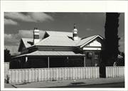
62 Barrack St Merredin
North side, mid-block, between Fifth and Bates Streets
Merredin
Wheatbelt
Constructed from 1907 to 1912
| Type | Status | Date | Documents |
|---|---|---|---|
| (no listings) |
| Type | Status | Date | Documents |
|---|---|---|---|
| (no listings) |
| Type | Status | Date | Grading/Management | |
|---|---|---|---|---|
| Category | ||||
| Municipal Inventory | Adopted | 16 Apr 1999 | Category 2 | |
| Statewide Hotel Survey | Completed | 01 Nov 1997 | ||
Good - With the exception of the front balcony, the building appears almost as constructed and has a reasonable integrity
| Name | Type | Year From | Year To |
|---|---|---|---|
| Charles Oldham & Alfred Cox | Architect | - | - |
Individual Building or Group
| Epoch | General | Specific |
|---|---|---|
| Original Use | COMMERCIAL | Hotel, Tavern or Inn |
| Present Use | COMMERCIAL | Hotel, Tavern or Inn |
| Style |
|---|
| Federation Filigree |
| Type | General | Specific |
|---|---|---|
| Wall | BRICK | Common Brick |
| Roof | METAL | Corrugated Iron |
| Other | TIMBER | Log |
| General | Specific |
|---|---|
| OCCUPATIONS | Hospitality industry & tourism |
This information is provided voluntarily as a public service. The information provided is made available in good faith and is derived from sources believed to be reliable and accurate. However, the information is provided solely on the basis that readers will be responsible for making their own assessment of the matters discussed herein and are advised to verify all relevant representations, statements and information.
Constructed from 1912
The Commercial Hotel is the last remaining accommodation hotel in the town and is of historic and social significance as a community meeting place.
One of the few two-storey buildings in the town, the hotel faces south on to the main shopping street, with a first floor cantilevered verandah. Two accommodation wings stretch back from the frontage, the eastern turning to form a central court, while the western extends further. Remaining in the front section are glassed wall and unglazed floor tiles at entrance doorways and a jarrah stair. There appears to be relatively few alterations internally.
Themes: Occupations - Hoteliers
With the exception of the front balcony, the building appears almost as constructed and has a reasonable integrity. Front balcony; addition of steel escape stair at rear; ground floor infill of central court; toilet addition on west side.
Good
| Name | Type | Year From | Year To |
|---|---|---|---|
| Charles Oldham & Alfred Cox | Architect | - | - |
| Owner | Category |
|---|---|
| Richard & Bell (Licencees) | Other Private |
This information is provided voluntarily as a public service. The information provided is made available in good faith and is derived from sources believed to be reliable and accurate. However, the information is provided solely on the basis that readers will be responsible for making their own assessment of the matters discussed herein and are advised to verify all relevant representations, statements and information.
Barrack St Merredin
West of Watson Road
Merredin
Wheatbelt
Constructed from 1945
| Type | Status | Date | Documents |
|---|---|---|---|
| (no listings) |
| Type | Status | Date | Documents |
|---|---|---|---|
| (no listings) |
| Type | Status | Date | Grading/Management | |
|---|---|---|---|---|
| Category | ||||
| Municipal Inventory | Adopted | 16 Apr 1999 | Category 4 | |
Not applicable - No evidence remains of the migrant camp
Historic Site
| Epoch | General | Specific |
|---|---|---|
| Present Use | INDUSTRIAL\MANUFACTURING | Other |
| Original Use | FARMING\PASTORAL | Other |
| Other Use | FARMING\PASTORAL | Other |
| General | Specific |
|---|---|
| PEOPLE | Early settlers |
| OUTSIDE INFLUENCES | World Wars & other wars |
This information is provided voluntarily as a public service. The information provided is made available in good faith and is derived from sources believed to be reliable and accurate. However, the information is provided solely on the basis that readers will be responsible for making their own assessment of the matters discussed herein and are advised to verify all relevant representations, statements and information.
Constructed from 1945
The site is of social and historic significance, once accommodating a large migrant camp.
The site is located on the eastern edge of the townsite, facing what was once the railway yards. Migrants were housed here (tents?) post WWII. The area is now an industrial estate.
Themes: People - Migrants Outside Influences - World War II
No evidence remains of the migrant camp.
Site Only
This information is provided voluntarily as a public service. The information provided is made available in good faith and is derived from sources believed to be reliable and accurate. However, the information is provided solely on the basis that readers will be responsible for making their own assessment of the matters discussed herein and are advised to verify all relevant representations, statements and information.
Barrack St Merredin
East of commercial centre and eastern rail crossing
Old Merredin Railway Yards
Merredin
Wheatbelt
Constructed from 1893
| Type | Status | Date | Documents |
|---|---|---|---|
| (no listings) |
| Type | Status | Date | Documents |
|---|---|---|---|
| (no listings) |
| Type | Status | Date | Grading/Management | |
|---|---|---|---|---|
| Category | ||||
| Municipal Inventory | Adopted | 16 Apr 1999 | Category 5 | |
Extant buildings are in fair to good condition The site has a low integrity in relation to what it once was
Individual Building or Group
| Epoch | General | Specific |
|---|---|---|
| Other Use | SOCIAL\RECREATIONAL | Other Community Hall\Centre |
| Original Use | Transport\Communications | Rail: Office or Administration Bldg |
| Present Use | EDUCATIONAL | Museum |
| Type | General | Specific |
|---|---|---|
| Wall | TIMBER | Weatherboard |
| Roof | METAL | Corrugated Iron |
| General | Specific |
|---|---|
| OUTSIDE INFLUENCES | World Wars & other wars |
This information is provided voluntarily as a public service. The information provided is made available in good faith and is derived from sources believed to be reliable and accurate. However, the information is provided solely on the basis that readers will be responsible for making their own assessment of the matters discussed herein and are advised to verify all relevant representations, statements and information.
Constructed from 1893
Merredin was once a significant railway town with a substantial railway work-force. The site contains remnants of prior use as railway yards and has a historical value. During World War II the Merredin Region was selected by the Army and Airforce as ideal locations for the building of stores and maintenance bases and the relocation from Perth of the 2/1st Army General Hospital. Today, the town still contains various remains of what was expected to be part of Western Australia's last stand against a Japanese invasion. Many of the items in the museum are privately owned and maintained and have come from local farmers who purchased the equipment from disposal sales in the late 50s, early 60s. The tanks were used for land clearing; the field guns became trailers and many a tin hat watered the sheep dog.
Immediately facing the entrance to the site - off Barrack Street between Duff Street and Telfer Avenue, is the single storey weatherboard and iron administration building, which has recently been re-roofed. The site contains various corrugated iron sheds, which house the museum.
Themes: Outside influence- World War II The 510 Regional Army Cadet Unit and Museum commenced operating on the site in 1994.
The site has a low integrity in relation to what it once was. The site has been much modified with all rail-lines arid some buildings removed.
Fair-Good
This information is provided voluntarily as a public service. The information provided is made available in good faith and is derived from sources believed to be reliable and accurate. However, the information is provided solely on the basis that readers will be responsible for making their own assessment of the matters discussed herein and are advised to verify all relevant representations, statements and information.
Barrack St Merredin
Air Observers Post
Atkinson's Haberdasher, Lister House
Merredin
Wheatbelt
Constructed from 1923
| Type | Status | Date | Documents |
|---|---|---|---|
| (no listings) |
| Type | Status | Date | Documents |
|---|---|---|---|
| (no listings) |
| Type | Status | Date | Grading/Management | |
|---|---|---|---|---|
| Category | ||||
| Municipal Inventory | Adopted | 16 Apr 1999 | Category 5 | |
Good - The outline of the building remains intact.
Individual Building or Group
| Epoch | General | Specific |
|---|---|---|
| Other Use | MILITARY | Other |
| Present Use | COMMERCIAL | Shop\Retail Store {single} |
| Original Use | COMMERCIAL | Shop\Retail Store {single} |
| Type | General | Specific |
|---|---|---|
| Wall | BRICK | Rendered Brick |
| Other | TIMBER | Other Timber |
| Other | METAL | Pressed Metal |
| Roof | METAL | Corrugated Iron |
| Other | METAL | Aluminium |
| General | Specific |
|---|---|
| OUTSIDE INFLUENCES | World Wars & other wars |
This information is provided voluntarily as a public service. The information provided is made available in good faith and is derived from sources believed to be reliable and accurate. However, the information is provided solely on the basis that readers will be responsible for making their own assessment of the matters discussed herein and are advised to verify all relevant representations, statements and information.
Constructed from 1923
This is the only two-storey shop in the town and the roof top was chosen for an air observer's post in WWII. For many years the building operated as Millar's Pharmacy, until May 1995, when the pharmacy relocated to larger premises and the vacated space was occupied by Atkinson's Haberdashery.
This two-storey shop faces south and is located in the main commercial street of the town. The street facade comprises a glass front at ground floor level, with a suspended awning, above and a first floor frontage with two windows divided into three vertically and two horizontally. The facade continues upward to create a parapet wall, with the words "Lister House" centrally placed near the top. The side walls at the top step down, to match the roof line. The first floor is reached via a covered stair on the west side, outside the building envelop, directly accessible from the street.
Themes: Outside Influences - World War II
The outline of the building remains intact. Modifications: Ground floor much altered; aluminium doors and windows.
Good
| Ref ID No | Ref Name | Ref Source | Ref Date |
|---|---|---|---|
| Merredin Tourist Information Centre (Inc.) |
This information is provided voluntarily as a public service. The information provided is made available in good faith and is derived from sources believed to be reliable and accurate. However, the information is provided solely on the basis that readers will be responsible for making their own assessment of the matters discussed herein and are advised to verify all relevant representations, statements and information.
Barrack St Merredin
Eastern end, south side
Agonas Flexuosa
Merredin
Wheatbelt
Constructed from 1911
| Type | Status | Date | Documents |
|---|---|---|---|
| (no listings) |
| Type | Status | Date | Documents |
|---|---|---|---|
| (no listings) |
| Type | Status | Date | Grading/Management | |
|---|---|---|---|---|
| Category | ||||
| Municipal Inventory | Adopted | 16 Apr 1999 | Category 2 | |
Good - The trees are well shaped and have a high integrity
Tree
| Epoch | General | Specific |
|---|---|---|
| Present Use | OTHER | Other |
| Original Use | OTHER | Other |
| General | Specific |
|---|---|
| DEMOGRAPHIC SETTLEMENT & MOBILITY | Settlements |
| SOCIAL & CIVIC ACTIVITIES | Community services & utilities |
This information is provided voluntarily as a public service. The information provided is made available in good faith and is derived from sources believed to be reliable and accurate. However, the information is provided solely on the basis that readers will be responsible for making their own assessment of the matters discussed herein and are advised to verify all relevant representations, statements and information.
Constructed from 1911
The peppermint trees are the result of early townscape improvement efforts and have a social and historical significance.
The peppermint trees line the edge of Barrack Street East, on the south side, within a strip of grass adjoining a car park. Agonas flexuosa occurs naturally in the south-west of Western Australia.
Themes: Social and Civic Activities - Townscape
The trees are well shaped and have a high integrity.
Good
This information is provided voluntarily as a public service. The information provided is made available in good faith and is derived from sources believed to be reliable and accurate. However, the information is provided solely on the basis that readers will be responsible for making their own assessment of the matters discussed herein and are advised to verify all relevant representations, statements and information.
Barrack St Merredin
Tourist Information Centre
Merredin
Wheatbelt
Constructed from 1975
| Type | Status | Date | Documents |
|---|---|---|---|
| (no listings) |
| Type | Status | Date | Documents |
|---|---|---|---|
| (no listings) |
| Type | Status | Date | Grading/Management | |
|---|---|---|---|---|
| Category | ||||
| Municipal Inventory | Adopted | 16 Apr 1999 | Category 4 | |
Very Good - The building is as constructed and has a very high integrity
Individual Building or Group
| Epoch | General | Specific |
|---|---|---|
| Original Use | SOCIAL\RECREATIONAL | Other Community Hall\Centre |
| Present Use | SOCIAL\RECREATIONAL | Other Community Hall\Centre |
| Type | General | Specific |
|---|---|---|
| Roof | TILE | Ceramic Tile |
| Wall | CONCRETE | Concrete Block |
| Other | METAL | Aluminium |
| General | Specific |
|---|---|
| OCCUPATIONS | Hospitality industry & tourism |
This information is provided voluntarily as a public service. The information provided is made available in good faith and is derived from sources believed to be reliable and accurate. However, the information is provided solely on the basis that readers will be responsible for making their own assessment of the matters discussed herein and are advised to verify all relevant representations, statements and information.
Constructed from 1975
The building has a social and architectural value, being well designed for its purpose and certainly well used. At the time of its construction it would have provided quite a contrast with other buildings in the town.
The building faces north onto a small grassed area adjoining Barrack Street, with its back to the railway. The coffee lounge is at the eastern end, with a glass front, the travel centre occupies the centre of the building, also with a glass front, while the toilets are at the western end, with a brick wall at the front. The roof has a single pitch northward over the coffee lounge and travel centre, extending to provide window shading and a verandah for outdoor eating, but is gabled over the toilets, which extend to the edge of the verandah.
Themes: Occupations - Tourism
The building is as constructed and has a very high integrity.
Very Good
This information is provided voluntarily as a public service. The information provided is made available in good faith and is derived from sources believed to be reliable and accurate. However, the information is provided solely on the basis that readers will be responsible for making their own assessment of the matters discussed herein and are advised to verify all relevant representations, statements and information.
Cnr Bates & Duff St s Merredin
north of town centre
Exhibition Hall
Merredin
Wheatbelt
Constructed from 1928
| Type | Status | Date | Documents |
|---|---|---|---|
| (no listings) |
| Type | Status | Date | Documents |
|---|---|---|---|
| (no listings) |
| Type | Status | Date | Grading/Management | |
|---|---|---|---|---|
| Category | ||||
| Municipal Inventory | Adopted | 16 Apr 1999 | Category 2 | |
Shire advised demolition - unsure of date or reason. Fair, but deteriorating, with some cracking in walls and buttraces; floor in need of some repair. The building has its original fabric intact and is of high integrity
| Name | Type | Year From | Year To |
|---|---|---|---|
| F. Telfer | Architect | - | - |
Individual Building or Group
| Epoch | General | Specific |
|---|---|---|
| Present Use | VACANT\UNUSED | Vacant\Unused |
| Other Use | MILITARY | Drill Hall |
| Original Use | SOCIAL\RECREATIONAL | Agricultural Hall |
| Type | General | Specific |
|---|---|---|
| Wall | CONCRETE | Concrete Block |
| Roof | METAL | Corrugated Iron |
| Other | TIMBER | Other Timber |
| Other | METAL | Aluminium |
| General | Specific |
|---|---|
| SOCIAL & CIVIC ACTIVITIES | Sport, recreation & entertainment |
This information is provided voluntarily as a public service. The information provided is made available in good faith and is derived from sources believed to be reliable and accurate. However, the information is provided solely on the basis that readers will be responsible for making their own assessment of the matters discussed herein and are advised to verify all relevant representations, statements and information.
Constructed from 1939, Constructed from 1928
The hall was constructed by the Merredin Agricultural Society, once a very strong institution in the town, giving the building a social and historic significance. The society was founded in 1918 and held its first show in 1919. The shows attracted their peak crowds in the late 1950s, early 1960s, after a two-day show was held for the first time in 1957.
The hall lies in an open area of the Recreation Ground, with the entrance road from Bates Street passing by it. The original building had a rectangular in plan and hipped roof with gablets. There were four buttraces on the end walls and seven on each side. There were four sets of double doors, one in the centre of each side. There were high windows on each of the longer sides, two between each buttrace. There is a patterned concrete block and corrugated iron, a gable-roofed addition at the northern end - the orderly room and weapons store constructed early in WWII.
Themes: Social and Civic Activities - Recreation
The building has its original fabric intact and is of high integrity.
Fair, but deteriorating, with some cracking in walls and buttraces; floor in need of some repair.
| Name | Type | Year From | Year To |
|---|---|---|---|
| F. Telfer: first Secretary Merredin Agricultural Society | Architect | - | - |
| Ref ID No | Ref Name | Ref Source | Ref Date |
|---|---|---|---|
| Barnett, Barbara "The History of Merredin" | Teachers College, Claremont |
This information is provided voluntarily as a public service. The information provided is made available in good faith and is derived from sources believed to be reliable and accurate. However, the information is provided solely on the basis that readers will be responsible for making their own assessment of the matters discussed herein and are advised to verify all relevant representations, statements and information.
Cnr Bates & Duff St s Merredin
Within Recreation Ground
Merredin
Wheatbelt
Constructed from 1930
| Type | Status | Date | Documents |
|---|---|---|---|
| (no listings) |
| Type | Status | Date | Documents |
|---|---|---|---|
| (no listings) |
| Type | Status | Date | Grading/Management | |
|---|---|---|---|---|
| Category | ||||
| Municipal Inventory | Adopted | 16 Apr 1999 | Category 2 | |
Demolition advised by local authority. Unsure of date or reason. Very Good - Because of continuous up-grading the fabric of the race track is not original, however there is a consistency and integrity in present facilities.
Other Built Type
| Epoch | General | Specific |
|---|---|---|
| Present Use | SOCIAL\RECREATIONAL | Other |
| Original Use | SOCIAL\RECREATIONAL | Other |
| Type | General | Specific |
|---|---|---|
| Wall | BRICK | Common Brick |
| Roof | METAL | Steel |
| General | Specific |
|---|---|
| SOCIAL & CIVIC ACTIVITIES | Sport, recreation & entertainment |
This information is provided voluntarily as a public service. The information provided is made available in good faith and is derived from sources believed to be reliable and accurate. However, the information is provided solely on the basis that readers will be responsible for making their own assessment of the matters discussed herein and are advised to verify all relevant representations, statements and information.
Constructed from 1930
The race track is of social significance. It occupies part of a one-hundred acre site reserved in the early 1930s, adjacent to the townsite, for recreation purposes. The high standard of facilities, including lighting and reticulation, provide a widely appreciated sporting venue for the town.
The race track is equipped with night lighting and the grass is reticulated with recycled waste water. Merredin had the first inland sewage treatment works in WA and was the first in the State to reticulate wastewater. There are associated buildings, including a grandstand.
Themes: Social and Civic Activities - Sport
Because of continuous up-grading the fabric of the race track is not original, however there is a consistency and integrity in present facilities.
Very Good
| Ref ID No | Ref Name | Ref Source | Ref Date |
|---|---|---|---|
| Barnett, Barbara "The History of Merredin" | Teachers College, Claremont |
This information is provided voluntarily as a public service. The information provided is made available in good faith and is derived from sources believed to be reliable and accurate. However, the information is provided solely on the basis that readers will be responsible for making their own assessment of the matters discussed herein and are advised to verify all relevant representations, statements and information.
Cnr Bates & Mitchell Sts Merredin
North-east Corner
Middleton's Building
Merredin
Wheatbelt
Constructed from 1930
| Type | Status | Date | Documents |
|---|---|---|---|
| (no listings) |
| Type | Status | Date | Documents |
|---|---|---|---|
| (no listings) |
| Type | Status | Date | Grading/Management | |
|---|---|---|---|---|
| Category | ||||
| Municipal Inventory | Adopted | 16 Apr 1999 | Category 2 | |
| Statewide Bank Survey | Completed | 01 Nov 1997 | ||
Good, although some cracking of render and fretting of brickwork. The external fabric of the building is intact, giving the building a high integrity.
Individual Building or Group
| Epoch | General | Specific |
|---|---|---|
| Original Use | COMMERCIAL | Bank |
| Present Use | COMMERCIAL | Office or Administration Bldg |
| Style |
|---|
| Inter-War Free Classical |
| Type | General | Specific |
|---|---|---|
| Roof | TILE | Ceramic Tile |
| Other | TIMBER | Other Timber |
| Wall | BRICK | Rendered Brick |
| General | Specific |
|---|---|
| OCCUPATIONS | Commercial & service industries |
This information is provided voluntarily as a public service. The information provided is made available in good faith and is derived from sources believed to be reliable and accurate. However, the information is provided solely on the basis that readers will be responsible for making their own assessment of the matters discussed herein and are advised to verify all relevant representations, statements and information.
Constructed from 1930
Obviously architect designed, this charming building successfully marries residential and office building forms. It makes an important townscape contribution and is of architectural significance.
The corner section of the building is symmetrically-designed around the street frontage with a central doorway and three windows onto each street - a pair of rectangular windows vertical in proportion, with a wider arched window at the end. Walls have horizontal banding in the render, with moulded keystones above openings, and provide a parapet with the roof behind. The front door has a flat canopy over. The house, which is integrated with the corner section of the building, is set back from both streets with its entrance from Bates Street. Walls of the house are brick to a coping above sill height (about half height), rendered above. Windows have brick sills, shallow arched brick on edge above and panes divided into six. -There is evidence of rising salt. The building has four tall chimneys, with a coping near the top two in the corner section and two in the house. Currently (Dec 1995) the building is occupied by T.J. Middleton, accountants (corner section) and the North Eastern Wheat belt Business Enterprise Centre (house).
Themes: Occupations - Bankers
The external fabric of the building is intact, giving the building a high integrity. Interior of corner section modernised; front door now glass and aluminium with side panel; near verandah of house filled in.
Good
This information is provided voluntarily as a public service. The information provided is made available in good faith and is derived from sources believed to be reliable and accurate. However, the information is provided solely on the basis that readers will be responsible for making their own assessment of the matters discussed herein and are advised to verify all relevant representations, statements and information.
SE Cnr Bates & Mitchell Sts Merredin
Merredin Palace Restaurant
Merredin
Wheatbelt
Constructed from 1930
| Type | Status | Date | Documents |
|---|---|---|---|
| (no listings) |
| Type | Status | Date | Documents |
|---|---|---|---|
| (no listings) |
| Type | Status | Date | Grading/Management | |
|---|---|---|---|---|
| Category | ||||
| Municipal Inventory | Adopted | 16 Apr 1999 | Category 2 | |
Good - The outline and street facades of the building remain intact and provide a high integrity
Individual Building or Group
| Epoch | General | Specific |
|---|---|---|
| Present Use | COMMERCIAL | Restaurant |
| Original Use | COMMERCIAL | Other |
| Type | General | Specific |
|---|---|---|
| Other | GLASS | Glass |
| Other | METAL | Aluminium |
| Wall | BRICK | Rendered Brick |
| Roof | METAL | Corrugated Iron |
| General | Specific |
|---|---|
| OCCUPATIONS | Commercial & service industries |
This information is provided voluntarily as a public service. The information provided is made available in good faith and is derived from sources believed to be reliable and accurate. However, the information is provided solely on the basis that readers will be responsible for making their own assessment of the matters discussed herein and are advised to verify all relevant representations, statements and information.
Constructed from 1930
This building has strong horizontal lines and dominates the adjoining road intersection. It is a good example of a purpose - designed garage and when compared with the design of modern garages it is evident how radically this activity type has changed. This building is considered to have architectural and historic significance, being constructed at a time when motoring was relatively new to Merredin and going through a growth phase.
This single-storeyed building was purpose-built as a garage abutting two street frontages, with a quarter-circle driveway at the corner. Parapet walls along the street frontages have banded decorative pilasters to create five bays to Bates Street and four bays to Mitchell Street. The top of the parapet has decorative mouldings. What was previously the workshop at the rear (now Merredin Motor Mart), on Mitchell Street, is set back from the street. Both the corner building and workshop have a consistent subdued paint scheme. There are not awnings apart from a canvas canopy above a shop entrance of recent construction.
Themes: Occupations - Motor Repair
The outline and street facades of the building remain intact and provide a high integrity
Good
This information is provided voluntarily as a public service. The information provided is made available in good faith and is derived from sources believed to be reliable and accurate. However, the information is provided solely on the basis that readers will be responsible for making their own assessment of the matters discussed herein and are advised to verify all relevant representations, statements and information.
Cnr Bates & Princess Sts Merredin
West side of road
Lion's Den
Merredin Football Club
Merredin
Wheatbelt
Constructed from 1941
| Type | Status | Date | Documents |
|---|---|---|---|
| (no listings) |
| Type | Status | Date | Documents |
|---|---|---|---|
| (no listings) |
| Type | Status | Date | Grading/Management | |
|---|---|---|---|---|
| Category | ||||
| Municipal Inventory | Adopted | 16 Apr 1999 | Category 1 | |
Fair - Despite modification recongisable the original fabric of the building is clearly providing a reasonable integrity
Individual Building or Group
| Epoch | General | Specific |
|---|---|---|
| Original Use | MILITARY | Mess or Recreation Hall |
| Present Use | SOCIAL\RECREATIONAL | Other Community Hall\Centre |
| Type | General | Specific |
|---|---|---|
| Wall | PLASTER | Fibrous Plaster Sheet |
| Roof | METAL | Corrugated Iron |
| General | Specific |
|---|---|
| OUTSIDE INFLUENCES | World Wars & other wars |
This information is provided voluntarily as a public service. The information provided is made available in good faith and is derived from sources believed to be reliable and accurate. However, the information is provided solely on the basis that readers will be responsible for making their own assessment of the matters discussed herein and are advised to verify all relevant representations, statements and information.
Constructed from 1941
Local knowledge states that this building was constructed as part of a base for counter-attack on Perth and Fremantle, should the metropolitan area have been taken by the Japanese during World War II. This conflicts with the commonly held view that if the enemy had landed in WA, Australia's defence forces would abandon the State and pull back to a line between Adelaide and Brisbane. This structure is considered to be of national importance because of its links to other war time buildings in the district.
The building is orientated east-west under a gable roof, with a northern extension at the rear under a gable roof of lesser height. There appears to have been a full width rear verandah, under a skillion roof, facing the wartime airfield to the west, which has now been filled in. At the eastern end of the building, facing Bates Street, there is a small gable roofed porch, apparently disused in favour of a side door to Princess Street and two doors at the rear near a parking area. The building has been progressively maintained with new cladding at the rear, aluminium windows and evaporative coolers being installed. The building is currently known as the "Lion's Den" because its main occupant is the Merredin Football Club, known as the Lions. There is a lion's head mural painted on the south facing slope of the roof of the building.
Themes: Outside Influences - World War II
Despite modifications recognisable the original fabric of the building is clearly providing a reasonable integrity. Modifications: Recladding at rear; toilet block addition under skillion roof north side; replacement of timber windows with aluminium installation of two evaporative coolers to ridge of roof; probably rear verandah infill.
Fair
| Ref ID No | Ref Name | Ref Source | Ref Date |
|---|---|---|---|
| Map of Merredin Townsite locating WWII Structures | Merredin Tourist & Information Centre (Inc) |
This information is provided voluntarily as a public service. The information provided is made available in good faith and is derived from sources believed to be reliable and accurate. However, the information is provided solely on the basis that readers will be responsible for making their own assessment of the matters discussed herein and are advised to verify all relevant representations, statements and information.
Bates St Merredin
REGISTERED AS PART OF 4035
Merredin
Wheatbelt
| Type | Status | Date | Documents |
|---|---|---|---|
| (no listings) |
| Type | Status | Date | Documents |
|---|---|---|---|
| (no listings) |
| Type | Status | Date | Grading/Management | |
|---|---|---|---|---|
| Category | ||||
| (no listings) | ||||
04035 Merredin Post Office Group
Individual Building or Group
| Epoch | General | Specific |
|---|---|---|
| Present Use | Transport\Communications | Comms: Housing or Quarters |
| Original Use | Transport\Communications | Comms: Housing or Quarters |
This information is provided voluntarily as a public service. The information provided is made available in good faith and is derived from sources believed to be reliable and accurate. However, the information is provided solely on the basis that readers will be responsible for making their own assessment of the matters discussed herein and are advised to verify all relevant representations, statements and information.
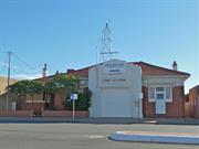
28 Bates St Merredin
Includes: Lot 168 Bates St, Merredin
Merredin
Wheatbelt
Constructed from 1920, Constructed from 1935
| Type | Status | Date | Documents |
|---|---|---|---|
| State Register | Registered | 29 Oct 2010 | HCWebsite.Listing+ListingDocument, HCWebsite.Listing+ListingDocument |
| Type | Status | Date | Documents |
|---|---|---|---|
| (no listings) |
| Type | Status | Date | Grading/Management | |
|---|---|---|---|---|
| Category | ||||
| Art Deco Significant Bldg Survey | Adopted | |||
| Fire & Rescue Service Heritage Inventory | Adopted | 30 Aug 1997 | ||
| Municipal Inventory | Adopted | 16 Apr 1999 | Category 2 | |
Good - The fabric of the building is intact providing a high integrity
| Name | Type | Year From | Year To |
|---|---|---|---|
| K C Duncan | Architect | - | - |
| Library Id | Title | Medium | Year Of Publication |
|---|---|---|---|
| 10219 | Merredin Fire Station Complex DRAFT | Heritage Study {Cons'n Plan} | 2014 |
Individual Building or Group
| Epoch | General | Specific |
|---|---|---|
| Present Use | GOVERNMENTAL | Government Residence |
| Original Use | GOVERNMENTAL | Fire Station |
| Original Use | GOVERNMENTAL | Government Residence |
| Present Use | GOVERNMENTAL | Fire Station |
| Style |
|---|
| Inter-War Stripped Classical |
| Type | General | Specific |
|---|---|---|
| Wall | BRICK | Rendered Brick |
| Wall | TIMBER | Other Timber |
| Roof | TILE | Terracotta Tile |
| Other | GLASS | Glass |
| Roof | METAL | Corrugated Iron |
| Wall | BRICK | Face Brick |
| General | Specific |
|---|---|
| SOCIAL & CIVIC ACTIVITIES | Community services & utilities |
| DEMOGRAPHIC SETTLEMENT & MOBILITY | Government policy |
| DEMOGRAPHIC SETTLEMENT & MOBILITY | Depression & boom |
This information is provided voluntarily as a public service. The information provided is made available in good faith and is derived from sources believed to be reliable and accurate. However, the information is provided solely on the basis that readers will be responsible for making their own assessment of the matters discussed herein and are advised to verify all relevant representations, statements and information.
Constructed from 1935
The building was architectural significance as a good example of a country fire station and residence.
The building is of domestic scale with a central garage, the opening emphasised by a rendered parapet wall with the words "Fire Station". On the north side of the garage is the fire station office with a pedestrian entry, flanked by windows. The house is on the south side of the garage, double fronted, with a separate entry. The door/windows to the office and the window of the front room of the house have a flat canopy over.
There is a plaque on the north side of the garage entrance, with the following inscription: "This building was erected by the WA Fire Brigades Board and opened by H.H. Harting Esq. J.P. Chairman Merredin Road Board 19 June 1935 Members of the WA Fire Brigades Board: (names) K C Duncan FRIA- Architect Perth Mortimone & Thompson- Contractor
The fabric of the building is intact providing a high integrity. Modifications: Front window to house replaced with aluminium
Good
| Name | Type | Year From | Year To |
|---|---|---|---|
| KC Duncan | Architect | - | - |
| Owner | Category |
|---|---|
| Fire and Emergency Services Authority of WA | State Gov't |
This information is provided voluntarily as a public service. The information provided is made available in good faith and is derived from sources believed to be reliable and accurate. However, the information is provided solely on the basis that readers will be responsible for making their own assessment of the matters discussed herein and are advised to verify all relevant representations, statements and information.
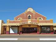
31 Bates St Merredin
East side, between Mitchell and Coronation Streets
Merredin
Wheatbelt
Constructed from 1897 to 1928
| Type | Status | Date | Documents |
|---|---|---|---|
| State Register | Registered | 31 May 1996 | HCWebsite.Listing+ListingDocument, HCWebsite.Listing+ListingDocument |
| Type | Status | Date | Documents |
|---|---|---|---|
| (no listings) |
| Type | Status | Date | Grading/Management | |
|---|---|---|---|---|
| Category | ||||
| Municipal Inventory | Adopted | 16 Apr 1999 | Category 1 | |
| Art Deco Significant Bldg Survey | Completed | |||
| Classified by the National Trust | Classified | 10 Sep 2001 | ||
Very Good - Apart from the rear addition, the building has a very high integrity
| Library Id | Title | Medium | Year Of Publication |
|---|---|---|---|
| 4887 | Cummins Theatre, Merredin : conservation plan. | Heritage Study {Cons'n Plan} | 1992 |
| 9337 | Cummins Theatre Merredin | Heritage Study {Cons'n Plan} | 2007 |
Individual Building or Group
| Epoch | General | Specific |
|---|---|---|
| Original Use | SOCIAL\RECREATIONAL | Theatre or Cinema |
| Present Use | SOCIAL\RECREATIONAL | Theatre or Cinema |
| Style |
|---|
| Other Style |
| Type | General | Specific |
|---|---|---|
| Wall | BRICK | Common Brick |
| Roof | METAL | Corrugated Iron |
| General | Specific |
|---|---|
| SOCIAL & CIVIC ACTIVITIES | Sport, recreation & entertainment |
This information is provided voluntarily as a public service. The information provided is made available in good faith and is derived from sources believed to be reliable and accurate. However, the information is provided solely on the basis that readers will be responsible for making their own assessment of the matters discussed herein and are advised to verify all relevant representations, statements and information.
Constructed from 1928, Constructed from 1992
Built in 1928, opening 11 October, Cummins Theatre is a.unique part of the town's cultural heritage. It was constructed largely of pressed bricks salvaged from several old Coolgardie hotels, and according to folklore these bricks contain three penny-weights of gold to the ton. The theatre's stage, decking and seating of imported Oregon timber were originally part of the Tivoli Theatre in Coolgardie, and the fly tower is made from imported Oregon timber. The theatre, which still houses its original ticket box, was financed,by James Cummins, the former owner of a Kalgoorlie brewery. The first tenants, William and Susan Brown, had the theatre equipped for sound production when 'talkies' were still relatively unknown. At that time, only one other theatre in Western Australia and five in Australia were equipped'to show sound films. 'The Singing Fool' with A1 Jolson was shown on 31 October, 1928, with 'Behind the Curtain' starring Myrna Loy being shown the following week. Operated for many years as a picture theatre the building.was eventually taken over by the Shire of Merredin in 1973. The theatre was restored in 1992, when a new backstage area was added. It is currently used by the local Repertory Club, established in 1933, and by visiting artists.
The main body of the theatre, behind a front parapet wall has buttraced sides. Extending forward of the theatre is the projection box above the entrance with a shop on either side abutting the street. The shops have separate doorway entrances from Bates Street but otherwise have glass window fronts with stained and patterned glass leadlight windows above. Window framing is bronze. A suspended awning over the footpath is curved in front of the theatre entrance.
There is a Bicentennial Plaque on the southern entrance pillar with the following inscription: "This theatre was built in 1928 by James Cummins largely with bricks salvaged from old Coolgardie hotels and reputed to contain three penny-weights of gold to the ton. The stage, decking and seating came from the Tivoli Theatre in Coolgardie. The theatre was one of the first in the State to be equipped with sound projection."
Apart from the rear addition, the building has a very high integrity.
Very Good
| Ref ID No | Ref Name | Ref Source | Ref Date |
|---|---|---|---|
| "Merredin Peak Heritage Trail" booklet | WA Heritage Committee | 1988 | |
| "Merredin Tourist" booklet | Merredin Tourist & Information Centre (Inc) | 1979 |
| Owner | Category |
|---|---|
| Shire of Merredin | Local Gov't |
This information is provided voluntarily as a public service. The information provided is made available in good faith and is derived from sources believed to be reliable and accurate. However, the information is provided solely on the basis that readers will be responsible for making their own assessment of the matters discussed herein and are advised to verify all relevant representations, statements and information.
33 Bates St Merredin
Homeswest Office
Merredin
Wheatbelt
Constructed from 1935
| Type | Status | Date | Documents |
|---|---|---|---|
| State Register | Registered | 11 Dec 2018 | HCWebsite.Listing+ListingDocument, HCWebsite.Listing+ListingDocument |
| Type | Status | Date | Documents |
|---|---|---|---|
| (no listings) |
| Type | Status | Date | Grading/Management | |
|---|---|---|---|---|
| Category | ||||
| Statewide Bank Survey | Completed | 01 Nov 1997 | ||
| Art Deco Significant Bldg Survey | Completed | 30 Jun 1994 | ||
| Municipal Inventory | Adopted | 16 Apr 1999 | Category 2 | |
17460 Agricultural Bank (fmr) and Manager's House (fmr), Merredin
Good
| Name | Type | Year From | Year To |
|---|---|---|---|
| State Housing Commission | Architect | - | - |
Individual Building or Group
| Epoch | General | Specific |
|---|---|---|
| Original Use | COMMERCIAL | Bank |
| Present Use | COMMERCIAL | Office or Administration Bldg |
| Style |
|---|
| Inter-War Free Classical |
| Type | General | Specific |
|---|---|---|
| Other | TIMBER | Other Timber |
| Wall | BRICK | Rendered Brick |
| Roof | METAL | Corrugated Iron |
| General | Specific |
|---|---|
| SOCIAL & CIVIC ACTIVITIES | Government & politics |
| OCCUPATIONS | Commercial & service industries |
This information is provided voluntarily as a public service. The information provided is made available in good faith and is derived from sources believed to be reliable and accurate. However, the information is provided solely on the basis that readers will be responsible for making their own assessment of the matters discussed herein and are advised to verify all relevant representations, statements and information.
Constructed from 1930, Constructed from 1972
The front facade of the building has architectural significance, being constructed at a time when there was confidence in the future of Merredin.
This single storey building in the art deco style has a symmetrical front facade with a central portico and pair of windows on both sides. Either side of two steps to the portico is a column with an Egyptian motif on the capital.
There is a plaque by the entrance, with the following inscription: "State Housing Commission Merredin Regional Office opened 23rd November 1972 by Hon. A. W. Bickerton MLA Minister for. Housing, Fisheries and Fauna Member for Pilbara. Original construction Agricultural Bank: Architects- State Housing Commission of WA Alterations Contractor- R.K. Ward & Co"
Although much altered inside and there are additions at the rear, the front facade has an integrity. 1972 internal alterations; brick additions at rear; aluminium front door.
Good
| Name | Type | Year From | Year To |
|---|---|---|---|
| State Housing Commission | Architect | - | - |
| Owner | Category |
|---|---|
| State Housing Commission | State Gov't |
This information is provided voluntarily as a public service. The information provided is made available in good faith and is derived from sources believed to be reliable and accurate. However, the information is provided solely on the basis that readers will be responsible for making their own assessment of the matters discussed herein and are advised to verify all relevant representations, statements and information.
Bates St Merredin
Offices
Merredin
Wheatbelt
Constructed from 1928
| Type | Status | Date | Documents |
|---|---|---|---|
| (no listings) |
| Type | Status | Date | Documents |
|---|---|---|---|
| (no listings) |
| Type | Status | Date | Grading/Management | |
|---|---|---|---|---|
| Category | ||||
| Statewide Bank Survey | Completed | 01 Nov 1997 | ||
Individual Building or Group
| Epoch | General | Specific |
|---|---|---|
| Present Use | COMMERCIAL | Office or Administration Bldg |
| Original Use | COMMERCIAL | Bank |
| Style |
|---|
| Inter-War Free Classical |
| Type | General | Specific |
|---|---|---|
| Wall | RENDER | Other Render |
| Roof | TILE | Ceramic Tile |
| General | Specific |
|---|---|
| OCCUPATIONS | Commercial & service industries |
This information is provided voluntarily as a public service. The information provided is made available in good faith and is derived from sources believed to be reliable and accurate. However, the information is provided solely on the basis that readers will be responsible for making their own assessment of the matters discussed herein and are advised to verify all relevant representations, statements and information.
30 Bates St Merredin
Merredin
Wheatbelt
Constructed from 1930
| Type | Status | Date | Documents |
|---|---|---|---|
| (no listings) |
| Type | Status | Date | Documents |
|---|---|---|---|
| RHP - Does not warrant assessment | Current | 12 Nov 2004 |
| Type | Status | Date | Grading/Management | |
|---|---|---|---|---|
| Category | ||||
| Art Deco Significant Bldg Survey | Completed | 30 Jun 1994 | ||
| Municipal Inventory | Adopted | 16 Apr 1999 | Category 2 | |
Good
Individual Building or Group
| Epoch | General | Specific |
|---|---|---|
| Present Use | HEALTH | Other |
| Original Use | RESIDENTIAL | Conjoined residence |
| Original Use | COMMERCIAL | Bank |
| Present Use | VACANT\UNUSED | Vacant\Unused |
| Style |
|---|
| Inter-War Free Classical |
| Type | General | Specific |
|---|---|---|
| Wall | BRICK | Rendered Brick |
| Roof | TILE | Ceramic Tile |
| General | Specific |
|---|---|
| OCCUPATIONS | Commercial & service industries |
| SOCIAL & CIVIC ACTIVITIES | Government & politics |
This information is provided voluntarily as a public service. The information provided is made available in good faith and is derived from sources believed to be reliable and accurate. However, the information is provided solely on the basis that readers will be responsible for making their own assessment of the matters discussed herein and are advised to verify all relevant representations, statements and information.
Constructed from 1930
Similar in character to the nearby Middietons Building, the building is a good example of a bank and adjoining residence.
The bank building, which.abuts the street, has a heavy sculptured front facade, with Ionic columns either side of a central doorway. Side windows flank the columns. The house is joined to the bank building but is set back from the street, with a variable roofline employing scroll finials. The house is occupied by Brian Duffy Bowen Therapist. The bank is vacant.
Themes: Occupations - Shopkeepers People - Hendy Cowan
The original building is intact to provide a high degree of integrity but the spanning wall addition detracts from the value.
Good
| Owner | Category |
|---|---|
| B. Duffy | Other Private |
This information is provided voluntarily as a public service. The information provided is made available in good faith and is derived from sources believed to be reliable and accurate. However, the information is provided solely on the basis that readers will be responsible for making their own assessment of the matters discussed herein and are advised to verify all relevant representations, statements and information.
Benson St Merredin
Merredin
Wheatbelt
Constructed from 1977
| Type | Status | Date | Documents |
|---|---|---|---|
| (no listings) |
| Type | Status | Date | Documents |
|---|---|---|---|
| RHP - Does not warrant assessment | Current | 28 Sep 2012 |
| Type | Status | Date | Grading/Management | |
|---|---|---|---|---|
| Category | ||||
| (no listings) | ||||
Fair
Individual Building or Group
| Epoch | General | Specific |
|---|---|---|
| Other Use | GOVERNMENTAL | Police Station or Quarters |
| General | Specific |
|---|---|
| SOCIAL & CIVIC ACTIVITIES | Law & order |
This information is provided voluntarily as a public service. The information provided is made available in good faith and is derived from sources believed to be reliable and accurate. However, the information is provided solely on the basis that readers will be responsible for making their own assessment of the matters discussed herein and are advised to verify all relevant representations, statements and information.
Bruce Rock - Quairading Rd Merredin
Bruce Rock - Quairading Rd, 1 Mile East of Yoting
Merredin
Wheatbelt
Constructed from 1986, Constructed from 1935
| Type | Status | Date | Documents |
|---|---|---|---|
| (no listings) |
| Type | Status | Date | Documents |
|---|---|---|---|
| RHP - Does not warrant assessment | Current | 30 Sep 2016 |
| Type | Status | Date | Grading/Management | |
|---|---|---|---|---|
| Category | ||||
| (no listings) | ||||
• The place is representative of the type of timber bridges constructed in the Wheatbelt during the 1930s and the subsequent ‘refurbishment’ of most of these in the latter part of the twentieth-century.
• It is probable the place represents an example of the use of sustenance labour for bridge construction in the Wheatbelt in the 1930s.
• It is probable the place represents government support for taking up agricultural land in the Wheatbelt from the 1900s to the 1930s as the gold boom subsided and the State’s population began to resettle in other areas, the key period for the establishment and expansion of the Wheatbelt.
• The place may represent the work of local governments in road bridge construction in the Wheatbelt.
Bridge 598, Salt River Tributary, York-Merredin Road, Pantapin comprises a road bridge with a timber superstructure on concrete abutments. The bridge measures 7 metres in length, and 8 metres in overall width. The bridge was constructed in 1935 and a concrete overlay was applied in 1986. White-painted timber and iron guard rails line both sides.
Pantapin is situated in the Wheatbelt region of Western Australia, approximately 27 kilometres northeast of Quairading. The Wheatbelt region of Western Australia wraps around the north and east side of the metropolitan area, includes the Avon Valley, and extends from Jurien Bay in the northwest, Lake King in the southeast, and the Shire of Yilgarn in the east. The area is predominantly mixed farming, namely wheat and sheep. Agricultural settlement of the region began in the Avon Valley in 1831 and, although a route from Perth to Albany was surveyed in 1830 it remained a sand track in the 1840s. In 1836 grazier Stephen Parker took up a selection at Dangin, 7 kilometres southwest of Quairading. However, it was not until 1859 that his son began to clear the land and establish the property. The town of Quairading was established in 1907 and the railway built in 1908. The area quickly developed with much of the land being taken up for farming. Initially called Ulakain, Pantapin originated as a railway siding when the Quairading to Bruce Rock line went through 1913. The site for the town was subsequently surveyed and gazetted in 1914 as Ulakine, being changed to Pantapin in 1921. After WWI British ex-service personnel were granted free passage to migrate to Australia. The result was almost 6 million hectares of land being set aside for the Soldier Settlement Scheme with the eastern Wheatbelt, and its network of railways, being identified as well-suited to this scheme. Post-WWI agricultural production in the region continued to increase albeit suffering some setbacks during the Depression as seen elsewhere. In 1935 the Commonwealth Government announced that 1 million pounds would be made available for a national program of works directed at unemployment relief. Sustenance work was subsequently undertaken in the area including the raising of the wall at Toapin Weir. According to the data held by Main Roads (Wheatbelt) Bridge 598, Salt River Tributary, York-Merredin Road, Pantapin was constructed in 1935. Following WWII the region saw increased economic growth and stability and both the State and local governments invested in infrastructure. However by the 1970s many families were forced to leave the Quairading district due to the economic downturn.
Historic site
| Epoch | General | Specific |
|---|---|---|
| Original Use | Transport\Communications | Road: Bridge |
| Present Use | Transport\Communications | Road: Bridge |
| Type | General | Specific |
|---|---|---|
| Other | METAL | Other Metal |
| Other | CONCRETE | Other Concrete |
| Other | TIMBER | Other Timber |
This information is provided voluntarily as a public service. The information provided is made available in good faith and is derived from sources believed to be reliable and accurate. However, the information is provided solely on the basis that readers will be responsible for making their own assessment of the matters discussed herein and are advised to verify all relevant representations, statements and information.

Chandler - Merredin Rd Merredin
East side of road, 5km north of Merredin
Durgutten ROck
Hunt's Campsite
Merredin
Wheatbelt
Constructed from 1864
| Type | Status | Date | Documents |
|---|---|---|---|
| (no listings) |
| Type | Status | Date | Documents |
|---|---|---|---|
| (no listings) |
| Type | Status | Date | Grading/Management | |
|---|---|---|---|---|
| Category | ||||
| Municipal Inventory | Adopted | 16 Apr 1999 | Category 2 | |
| Register of the National Estate | Indicative Place | |||
Fair
Historic Site
| Epoch | General | Specific |
|---|---|---|
| Original Use | GOVERNMENTAL | Reservoir or Dam |
| Original Use | Transport\Communications | Water: Other |
| Present Use | SOCIAL\RECREATIONAL | Other |
| Type | General | Specific |
|---|---|---|
| Other | STONE | Local Stone |
| General | Specific |
|---|---|
| DEMOGRAPHIC SETTLEMENT & MOBILITY | Exploration & surveying |
| PEOPLE | Early settlers |
This information is provided voluntarily as a public service. The information provided is made available in good faith and is derived from sources believed to be reliable and accurate. However, the information is provided solely on the basis that readers will be responsible for making their own assessment of the matters discussed herein and are advised to verify all relevant representations, statements and information.
Constructed from 1864
It was Assistant Surveyor Charles Hunt who recognised the region's pastoral potential in a series of exploratory surveys in 1864-66. In honour of his patron, Governor Hampton, Hunt named the region Hampton Plains. In the year 1866, he made his third journey into Hampton Plains; this was the biggest and best equipped he had undertaken. The party comprised four white men who were experienced bushmen, three natives and James Turner who had four pensioners and four probationer convicts under him. The convicts were to be used for road making and for the sinking of wells and making other water storages. The party established a track linking waterholes and constructed wells and dams along a route which became known as the York to Goldfields Road. The route of this expedition is marked by a series of "Hunts Wells" and "Hunts Dam" localities. Hunt's Dam in Merredin is one of those dams and is a most beautiful site. Its surrounds comprise of native bushlands, seasonal wildflowers and Durgutten rock. The area is excellent for the adventurous bush-walker and also serves as a popular picnic spot.
Themes: Population Settlement and Mobility - Exploration People - Assistant Surveyor Charles Hunt
Fair
| Ref ID No | Ref Name | Ref Source | Ref Date |
|---|---|---|---|
| "Merredin Peak Heritage Trail" booklet | WA Heritage Committee | 1988 | |
| "Merredin Tourist" booklet | Merredin Tourist & Information Centre (Inc) | 1979 | |
| Law, F.A. "The History of the Merredin District" | Merredin Road Board | 1961 |
This information is provided voluntarily as a public service. The information provided is made available in good faith and is derived from sources believed to be reliable and accurate. However, the information is provided solely on the basis that readers will be responsible for making their own assessment of the matters discussed herein and are advised to verify all relevant representations, statements and information.