Local Government
Merredin
Region
Wheatbelt
Mitchell St Merredin
Merredin District Hall
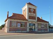
Merredin Town Hall (fmr) incl. Clock Tower Building
Road Board Office (fmr)
Merredin
Wheatbelt
Constructed from 1925 to 1993
| Type | Status | Date | Documents |
|---|---|---|---|
| State Register | Registered | 26 Feb 1999 | HCWebsite.Listing+ListingDocument, HCWebsite.Listing+ListingDocument |
| Type | Status | Date | Documents |
|---|---|---|---|
| (no listings) |
| Type | Status | Date | Grading/Management | |
|---|---|---|---|---|
| Category | ||||
| Register of the National Estate | Indicative Place | |||
| Art Deco Significant Bldg Survey | Completed | 30 Jun 1994 | ||
| Classified by the National Trust | Classified | 02 Apr 1983 | ||
| Register of the National Estate | Nominated | 30 May 1984 | ||
| Municipal Inventory | Adopted | 16 Apr 1999 | Category 2 | |
Good, although some cracking - The building that remains if of high integrity.
| Name | Type | Year From | Year To |
|---|---|---|---|
| Pickering W G | Architect | - | - |
| Library Id | Title | Medium | Year Of Publication |
|---|---|---|---|
| 10003 | Merredin Town Hall (fmr) | Heritage Study {Cons'n Plan} | 2012 |
Individual Building or Group
| Epoch | General | Specific |
|---|---|---|
| Original Use | GOVERNMENTAL | Town, Shire or District Hall |
| Present Use | SOCIAL\RECREATIONAL | Other Community Hall\Centre |
| Style |
|---|
| Inter-War Free Classical |
| Type | General | Specific |
|---|---|---|
| Roof | TILE | Aluminium Tile |
| Wall | BRICK | Common Brick |
| General | Specific |
|---|---|
| SOCIAL & CIVIC ACTIVITIES | Government & politics |
This information is provided voluntarily as a public service. The information provided is made available in good faith and is derived from sources believed to be reliable and accurate. However, the information is provided solely on the basis that readers will be responsible for making their own assessment of the matters discussed herein and are advised to verify all relevant representations, statements and information.
Constructed from 1925
As the town of Merredin grew larger and more prosperous an obvious need developed for a public meeting place and venue for social occasions. The original hall and Road Board Office, a wooden building, was opened in 1913. This event was celebrated with a Grand Ball and Banquet attended by "all of Merredin's beauty and chivalry". With the exception of the clock, which-looks a little too small, the building is well proportioned and would have been a significant addition to the town at the time of construction in 1924/5. The building is of architectural and social value.
The original wooden hall on the site was opened by the Hon. T. Bath 23 April, 1913. The hall measured 60' x 40' and cost £360. The brick and tile building that remains is the former Road Board Offices that were constructed on the property boundary in front of the hall since demolished. The building which opened 20 May, 1925 is symmetrical with the entrance at the foot of the tower and office accommodation either side. The tower has clocks on three sides, gablets on two sides and the words "MERREDIN DISTRICT HALL" centrally placed. The date "1925" appears over the entrance, beneath a curved canopy. The north side (rear) has been rendered and has a toilet block addition.
The western office section has a centrally placed foundation stone, adjoining the street, with the following inscription: "This stone was laid by W.C. Woolcar J.P.' Chairman Merredin Road Board on 16th November 1924 W.J. Cohn C.E. Secretary W. Geo Pickering, Jas R. Parker Aria WA Builder Architect" Matching the above stone is another stone in the eastern office section, with the following inscription: "The clock in this tower was erected by the residents of the district in memory of the soldiers who laid down their lives in the Great War 1914-1918. This tablet was unveiled by Brigadier - General A.J. Bessell-Browne CB CMG DSO VD (F), on 25th April 1928." By the entrance is a Bicentennial Plaque with the following inscription: "Merredin's growth after 1920 prompted the newly formed Road Board to build a public meeting place. The original wooden hall and Board Office was opened in 1913. In 1924 the chairman of the Road Board, Mr G. Woolgar, began a campaign to renovate the hall. A loan of £7,000 was raised and the front brick section of the hall was opened in May 1925.
The building that remains is of high integrity. Offices added along east wall 1944; west section remodelled 1958; wall at rear demolished January 1978; subsequent toilet block addition.
Good
| Name | Type | Year From | Year To |
|---|---|---|---|
| W. Geo Pickering (ARIA W.A.) | Architect | - | - |
| Ref ID No | Ref Name | Ref Source | Ref Date |
|---|---|---|---|
| "Merredin Tourist" brochure | Merredin Tourist & Information Centre (Inc) | 1979 | |
| "Merredin Peak Heritage Trail" booklet | WA Heritage Committee | 1988 |
| Owner | Category |
|---|---|
| Shire of Merredin | Local Gov't |
This information is provided voluntarily as a public service. The information provided is made available in good faith and is derived from sources believed to be reliable and accurate. However, the information is provided solely on the basis that readers will be responsible for making their own assessment of the matters discussed herein and are advised to verify all relevant representations, statements and information.
Muscat St , Cnr Cohn St Merredin
Old Cemetery
Merredin
Wheatbelt
| Type | Status | Date | Documents |
|---|---|---|---|
| (no listings) |
| Type | Status | Date | Documents |
|---|---|---|---|
| (no listings) |
| Type | Status | Date | Grading/Management | |
|---|---|---|---|---|
| Category | ||||
| Municipal Inventory | Adopted | 16 Apr 1999 | Category 2 | |
Good The cemetery retains the original form and has a high integrity
Other Built Type
| Epoch | General | Specific |
|---|---|---|
| Present Use | MONUMENT\CEMETERY | Cemetery |
| Original Use | MONUMENT\CEMETERY | Cemetery |
| General | Specific |
|---|---|
| SOCIAL & CIVIC ACTIVITIES | Religion |
This information is provided voluntarily as a public service. The information provided is made available in good faith and is derived from sources believed to be reliable and accurate. However, the information is provided solely on the basis that readers will be responsible for making their own assessment of the matters discussed herein and are advised to verify all relevant representations, statements and information.
The cemetery contains grave markers for many early pioneers of the district.
The cemetery is situated in a residential part of the town. It contains native trees and shrubs to provide a natural bush setting.
Themes: Social and Civic Activities - Burial People - Early Settlers
The cemetery retains its original form and has a high integrity.
Good
| Owner | Category |
|---|---|
| Shire of Merredin | Local Gov't |
This information is provided voluntarily as a public service. The information provided is made available in good faith and is derived from sources believed to be reliable and accurate. However, the information is provided solely on the basis that readers will be responsible for making their own assessment of the matters discussed herein and are advised to verify all relevant representations, statements and information.
Old York Rd Merredin
Old York/Goldfields Rd Immediately east of Chandler - Merredin Road
Cobb & Co Stopping Place
King's Campsite
Merredin
Wheatbelt
Constructed from 1889
| Type | Status | Date | Documents |
|---|---|---|---|
| (no listings) |
| Type | Status | Date | Documents |
|---|---|---|---|
| RHP - Does not warrant assessment | Current | 13 Mar 2020 |
| Type | Status | Date | Grading/Management | |
|---|---|---|---|---|
| Category | ||||
| Municipal Inventory | Adopted | 16 Apr 1999 | Category 2 | |
Poor - Little evidence remains of earlier occupation and the site has a low integrity
Historic Site
| Epoch | General | Specific |
|---|---|---|
| Other Use | Transport\Communications | Road: Other |
| Original Use | OTHER | Other |
| Present Use | SOCIAL\RECREATIONAL | Other |
| Other Use | RESIDENTIAL | Other |
| Type | General | Specific |
|---|---|---|
| Wall | CONCRETE | Concrete Block |
| General | Specific |
|---|---|
| TRANSPORT & COMMUNICATIONS | Road transport |
| DEMOGRAPHIC SETTLEMENT & MOBILITY | Settlements |
This information is provided voluntarily as a public service. The information provided is made available in good faith and is derived from sources believed to be reliable and accurate. However, the information is provided solely on the basis that readers will be responsible for making their own assessment of the matters discussed herein and are advised to verify all relevant representations, statements and information.
Constructed from 1891, Constructed from 1889
The area is of historic significance as Henry King's campsite when the area was first surveyed in 1889-90, later to become the original Merredin town site. The original townsite was officially named Merredin Peak Reserve 2914 in the Government Gazette of March 19th, 1891. However, settlers found it easier and cheaper to squat on Crown Land. Surveyor Lewis was sent to Merredin to assess the situation and recommended the survey of a town area on the north side of the railway line.
At this location the Goldfields Road has been realigned to the north some 100 m to accommodate the Merredin Golf Course which has been established on the western and northern sides of Merredin Peak. On the south side of Goldfields Road in the lee of Merredin Peak is a sheltered area where Assistant Surveyor Henry King established a camp by a water hole (one of two), when blazing a track from York to the Goldfields and conducting a comprehensive survey of the Merredin area in 1889-90. The site became a recognised stage of the journey from the coast to the Goldfields and cinders from the prospector's campfires can still be seen. The original Merredin Townsite was established in this area - a datum peg to mark the corner of Lot 1 is located approximately 20 metres north of a Bicentennial Plaque and is now marked by a slab of concrete on the 11th fairway. An old brick lined well (the second water hole) was for many years a hazard on the 11th hole and has now been filled in. Within a couple of metres of the realigned road reserve, clearly visible on the north side, is a stone and concrete wall about 1m high x 300mm wide x 10m long, said to be part of the stables of the original hotel and a stopping place for Cobb & Co coaches to the Goldfields in the 1890s. (The actual Cobb & Co staging post is believed to have been approximately 2 km west along Goldfields Road, at Whitehead's Rock.)
Themes: Population - Settlement & Mobility Transport and Communications - Road
Little evidence remains of earlier occupation and the site has a low integrity.
Poor
| Ref ID No | Ref Name | Ref Source | Ref Date |
|---|---|---|---|
| "Merredin Peak Heritage Trail" booklet | WA Heritage Committee | 1988 | |
| "Merredin Tourist" booklet | Merredin Tourist & Information Centre (Inc) | 1979 |
This information is provided voluntarily as a public service. The information provided is made available in good faith and is derived from sources believed to be reliable and accurate. However, the information is provided solely on the basis that readers will be responsible for making their own assessment of the matters discussed herein and are advised to verify all relevant representations, statements and information.
Lot 1353 Pollack Av Merredin
Opposite the end of Throssell Road, on the east side of the street.
Brewery House
Brewery Site
Merredin
Wheatbelt
Constructed from 1928
| Type | Status | Date | Documents |
|---|---|---|---|
| (no listings) |
| Type | Status | Date | Documents |
|---|---|---|---|
| (no listings) |
| Type | Status | Date | Grading/Management | |
|---|---|---|---|---|
| Category | ||||
| Municipal Inventory | Adopted | 16 Apr 1999 | Category 2 | |
| Classified by the National Trust | Classified | 02 Mar 1982 | ||
| Register of the National Estate | Indicative Place | |||
| Restrictive Covenant | YES | |||
| Register of the National Estate | Nominated | 23 Dec 1982 | ||
Good - The original fabric is intact giving the house and out-buildings a high integrity
Individual Building or Group
| Epoch | General | Specific |
|---|---|---|
| Present Use | RESIDENTIAL | Other |
| Original Use | RESIDENTIAL | Other |
| Type | General | Specific |
|---|---|---|
| Roof | METAL | Corrugated Iron |
| Wall | BRICK | Painted Brick |
| Other | TIMBER | Log |
| General | Specific |
|---|---|
| SOCIAL & CIVIC ACTIVITIES | Community services & utilities |
This information is provided voluntarily as a public service. The information provided is made available in good faith and is derived from sources believed to be reliable and accurate. However, the information is provided solely on the basis that readers will be responsible for making their own assessment of the matters discussed herein and are advised to verify all relevant representations, statements and information.
Constructed from 1928
The building group is of historical significance, with a construction date in the later 1920s, a boom period in development of the town.
The house and two out-buildings occur in a part of the town which is now sparsely developed but once contained'a brewery. (The brewery produced Kalgoorlie Bitter and Oatmeal Stout as well as its own Merredin Bitter and Westland-Lager). The house is approximately square in plan, with a verandah all around. The verandah has a rendered brick wall, with coping,-about,one metre in height.'The verandah has a battened plaster ceiling. The hipped roof has gable extensions over doorways at different heights - two to the front (north facing) and one to the street (west facing).. Gable pediments are faced with patterned pressed metal. The brick work of the house is .painted but remains unpainted on the two outbuildings - a store and garage. The garage is located on the Pollock Avenue street alignment and has a gable roof and pressed metal pediment to match the house.
Themes: People - Cummins
The original fabric is intact giving the house and out-buildings a high integrity. Although interior not inspected, there appears to be very few alterations.
Good
| Owner | Category |
|---|---|
| B&B Read | Other Private |
This information is provided voluntarily as a public service. The information provided is made available in good faith and is derived from sources believed to be reliable and accurate. However, the information is provided solely on the basis that readers will be responsible for making their own assessment of the matters discussed herein and are advised to verify all relevant representations, statements and information.
SE Cnr Railway Av & Goldfields Rd Merredin
RAAF Stores
Merredin
Wheatbelt
Constructed from 1940
| Type | Status | Date | Documents |
|---|---|---|---|
| (no listings) |
| Type | Status | Date | Documents |
|---|---|---|---|
| (no listings) |
| Type | Status | Date | Grading/Management | |
|---|---|---|---|---|
| Category | ||||
| Municipal Inventory | Adopted | 16 Apr 1999 | Category 2 | |
Fair to good - While both buildings have been modified, their original fabric is largely intact providing very high integrity. Probably the northern building is the better of the two as it retains its original roof line.
Other Built Type
| Epoch | General | Specific |
|---|---|---|
| Present Use | COMMERCIAL | Other |
| Original Use | MILITARY | Magazine or Store |
| Other Use | SOCIAL\RECREATIONAL | Other Sports Building |
| Type | General | Specific |
|---|---|---|
| Roof | METAL | Corrugated Iron |
| Wall | METAL | Corrugated Iron |
| Other | CONCRETE | Concrete Slab |
| Roof | TIMBER | Other Timber |
| General | Specific |
|---|---|
| OUTSIDE INFLUENCES | World Wars & other wars |
This information is provided voluntarily as a public service. The information provided is made available in good faith and is derived from sources believed to be reliable and accurate. However, the information is provided solely on the basis that readers will be responsible for making their own assessment of the matters discussed herein and are advised to verify all relevant representations, statements and information.
Constructed from 1940
Local knowledge states that these buildings were constructed as part of a base for counterattack on Perth and Fremantle, should the metropolitan area have been taken by the Japanese during World War II. This conflicts with the commonly held view that if the enemy had landed in WA, Australia's defence forces would abandon the State and pull back to a line between Adelaide and Brisbane. These structures are considered to be of national importance
These two massive buildings, each originally identical, approximately 100m x 80m and about 200m apart, have the traditional curved aircraft hanger appearance and were located adjacent to the wartime airfield. However, they were not used as aircraft hangers but for general storage by the RAAF. The buildings were not capable of storing aircraft - they were designed with two rows of intermediate supports and without doors at the ends. Access was via three doors on each side of each building, with a train line passing through those at the western end. The curve of the roof in the centre of each side is broken with a raised section to accommodate windows for a row of offices, which lined both sides of both buildings. Some major beams are steel but otherwise all framing is in timber. Windows to the offices were timber framed. Originally the buildings had irregular end canopies to make them look like water when viewed from the air (removed immediately post-war). The southern building.is currently occupied by Phillbourne Manufacturing Pty Ltd; the northern by Merredin Freight Lines.
Themes: Outside Influences - World War II
While both buildings have been modified, their original fabric is largely intact providing very high integrity. Probably the northern building is the better of the two as it retains its original roof line. Modifications: Wartime camouflage canopies removed; northern building has had doors added at eastern end but is otherwise close to original; southern building has had side offices removed and a south facing roof light and a steel gantry crane installed.
Fair-Good
| Ref ID No | Ref Name | Ref Source | Ref Date |
|---|---|---|---|
| Map of Merredin townsite locating WWII structures | Merredin Tourist & Information Centre (Inc) | ||
| "Merredin Tourist" booklet | Merredin Tourist & Information Centre (Inc) | 1979 |
This information is provided voluntarily as a public service. The information provided is made available in good faith and is derived from sources believed to be reliable and accurate. However, the information is provided solely on the basis that readers will be responsible for making their own assessment of the matters discussed herein and are advised to verify all relevant representations, statements and information.
South Av Merredin
Merredin
Wheatbelt
Constructed from 1973
| Type | Status | Date | Documents |
|---|---|---|---|
| (no listings) |
| Type | Status | Date | Documents |
|---|---|---|---|
| (no listings) |
| Type | Status | Date | Grading/Management | |
|---|---|---|---|---|
| Category | ||||
| Catholic Church Inventory | Adopted | 01 Jul 1998 | ||
Individual Building or Group
| Epoch | General | Specific |
|---|---|---|
| Present Use | RELIGIOUS | Church, Cathedral or Chapel |
| Original Use | RELIGIOUS | Church, Cathedral or Chapel |
| Type | General | Specific |
|---|---|---|
| Wall | BRICK | Common Brick |
| Roof | TILE | Ceramic Tile |
| General | Specific |
|---|---|
| SOCIAL & CIVIC ACTIVITIES | Religion |
This information is provided voluntarily as a public service. The information provided is made available in good faith and is derived from sources believed to be reliable and accurate. However, the information is provided solely on the basis that readers will be responsible for making their own assessment of the matters discussed herein and are advised to verify all relevant representations, statements and information.
Todd & Barrack Sts Merredin
Merredin
Wheatbelt
Constructed from 1893
| Type | Status | Date | Documents |
|---|---|---|---|
| (no listings) |
| Type | Status | Date | Documents |
|---|---|---|---|
| RHP - Assessed - Below Threshold | Current | 23 Feb 2007 |
| Type | Status | Date | Grading/Management | |
|---|---|---|---|---|
| Category | ||||
| (no listings) | ||||
The Meredin Railway Precinct consists of an extensive number of elements and therefore the condition is variable. The properties range from commercial sites to vacant railway buildings and landscaped elements. In general the condition is poor to good.
| Library Id | Title | Medium | Year Of Publication |
|---|---|---|---|
| 9808 | 18 Kitchener Road, Merredin | Conservation works report | 2011 |
Individual Building or Group
| Epoch | General | Specific |
|---|---|---|
| Original Use | Transport\Communications | Rail: Other |
| General | Specific |
|---|---|
| TRANSPORT & COMMUNICATIONS | Rail & light rail transport |
This information is provided voluntarily as a public service. The information provided is made available in good faith and is derived from sources believed to be reliable and accurate. However, the information is provided solely on the basis that readers will be responsible for making their own assessment of the matters discussed herein and are advised to verify all relevant representations, statements and information.
Lot 1503 Todd St Merredin
inc Waiting Rms, Parcels Office, Refreshment Rms, Signal Cabin, Water Tower, Platform and Waterfall On south side of railway line, between French Ave and Allenby St
Merredin Railway Station Museum
Old Railway Station
Merredin
Wheatbelt
Constructed from 1893 to 1978
| Type | Status | Date | Documents |
|---|---|---|---|
| State Register | Registered | 26 Feb 1999 | HCWebsite.Listing+ListingDocument, HCWebsite.Listing+ListingDocument |
| Type | Status | Date | Documents |
|---|---|---|---|
| (no listings) |
| Type | Status | Date | Grading/Management | |
|---|---|---|---|---|
| Category | ||||
| Municipal Inventory | Adopted | 16 Apr 1999 | Category 1 | |
| Classified by the National Trust | Classified | 08 Jul 2002 | ||
| Statewide Lge Timber Str Survey | Completed | 11 Dec 1998 | ||
| Statewide Railway Heritage Surve | Completed | 01 Mar 1994 | ||
| Register of the National Estate | Registered | 30 Jun 1992 | ||
17641 Merredin Railway Precinct
Very Good - The station buildings were constructed over about a 20 year period just after the turn of the century and have a very high integrity. Shire advises Water Fall demolished, unsure of date.
| Library Id | Title | Medium | Year Of Publication |
|---|---|---|---|
| 5134 | Conservation plan : Merredin Railway Station Group. | Heritage Study {Cons'n Plan} | 2001 |
| 11358 | Cast iron pillar boxes of Western Australia: An early history of the J & E Ledger foundry | Book | 2015 |
| 3811 | Merredin Railway Water Tower and Tank : heritage assessment. | Heritage Study {Other} | 1995 |
Individual Building or Group
| Epoch | General | Specific |
|---|---|---|
| Original Use | Transport\Communications | Rail: Railway Station |
| Present Use | EDUCATIONAL | Museum |
| Style |
|---|
| Federation Arts and Crafts |
| Type | General | Specific |
|---|---|---|
| Wall | BRICK | Face Brick |
| Wall | BRICK | Rendered Brick |
| Wall | METAL | Steel |
| Roof | TILE | Terracotta Tile |
| Wall | TIMBER | Weatherboard |
| General | Specific |
|---|---|
| DEMOGRAPHIC SETTLEMENT & MOBILITY | Land allocation & subdivision |
| SOCIAL & CIVIC ACTIVITIES | Cultural activities |
| TRANSPORT & COMMUNICATIONS | Rail & light rail transport |
This information is provided voluntarily as a public service. The information provided is made available in good faith and is derived from sources believed to be reliable and accurate. However, the information is provided solely on the basis that readers will be responsible for making their own assessment of the matters discussed herein and are advised to verify all relevant representations, statements and information.
Constructed from 1905, Constructed from 1923
01577 Merredin Railway Station Group
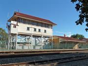
The railway line determined the final location of Merredin in 1893 and the station, built in 1895, was one of the first on the eastern railway. The first resident officer, Mr H.J. Cooper, described it as "as open shed 12 x 18 feet on a platform about 200 feet long ... (with) no shelter of any description." .He and his family 'resided' in a canvas tent. Merredin's status as a rail and commercial centre was secured when the locomotive depot at Southern Cross was shifted to Merredin in 1904. With branch lines serving both northern and southern wheatbelt areas, Merredin opened as a booking station in 1905. The station expanded to include the cellar (1906), the signal box housing 95 levers (1913), waiting rooms with a Romanesque arch (1917) and parcels office and refreshment rooms (1923). The latter were built with salmon tinted Coolgardie bricks salvaged from the Golden Gate, Hannan Street and Kallaroo Stations after the heyday of the goldrush. The railway station was converted into a museum by the Merredin Museum and Historical Society after a new station was built in 1968. The museum opened in 1978. The building group is an important collection of early railway structures and also has a social value arising from the community effort to create and operate the museum.
The building group comprises four buildings, end to end, on an island platform. Entry to the museum is from the eastern end into what was originally the parcels office (1923), later the main station building. The next building is the elevated signal box (1913), followed by a building of toilets and waiting rooms (1917) and finally refreshment rooms (1923), built in the same style as the parcels office, with a cellar (1906) used for storage of perishables and cool drinks.
There is a plaque by the museum entrance stating that renovation work carried out by the Merredin Historical Society was funded by the Department of Education Employment and Training, July 1993 - January 1994, under a local employment program.
The station buildings were constructed over about a 20 year period just after the turn of the century and have a very high integrity.
Very Good
| Ref ID No | Ref Name | Ref Source | Ref Date |
|---|---|---|---|
| "The Old Station Museum" booklet | Merredin Museum & Historical Society | undated | |
| "Merredin Tourist" booklet | undated | ||
| "Merredin Peak Heritage Trail" booklet | WA Heritage Committee | 1988 | |
| Merredin Tourist & Information Centre (Inc) |
| Owner | Category |
|---|---|
| Department of Transport | State Gov't |
This information is provided voluntarily as a public service. The information provided is made available in good faith and is derived from sources believed to be reliable and accurate. However, the information is provided solely on the basis that readers will be responsible for making their own assessment of the matters discussed herein and are advised to verify all relevant representations, statements and information.
Mukinbudin
Merredin
Wheatbelt
| Type | Status | Date | Documents |
|---|---|---|---|
| (no listings) |
| Type | Status | Date | Documents |
|---|---|---|---|
| (no listings) |
| Type | Status | Date | Grading/Management | |
|---|---|---|---|---|
| Category | ||||
| (no listings) | ||||
Other Built Type
This information is provided voluntarily as a public service. The information provided is made available in good faith and is derived from sources believed to be reliable and accurate. However, the information is provided solely on the basis that readers will be responsible for making their own assessment of the matters discussed herein and are advised to verify all relevant representations, statements and information.
Mundaring
P25251 Goldfields Water Supply Scheme is part of this place and is on the National Heritage List. Starts in Mundaring, at Mundaring Weir and travels through the Shires of Mundaring, Northam, Cunderdin, Tammin, Kellerberrin, Merredin, Westonia, Yilgarn, Coolgardie and Kalgoorlie-Boulder.
Golden Pipeline
Mundaring
Metropolitan
Constructed from 1898
| Type | Status | Date | Documents |
|---|---|---|---|
| State Register | Registered | 08 Dec 2022 | HCWebsite.Listing+ListingDocument, HCWebsite.Listing+ListingDocument |
| Type | Status | Date | Documents |
|---|---|---|---|
| (no listings) |
| Type | Status | Date | Grading/Management | |
|---|---|---|---|---|
| Category | ||||
| (no listings) | ||||
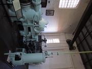
25251 Goldfields Water Supply Scheme (NHL)
• The place is an excellent example of an initiative by the Western Australian Government to provide water to the Goldfields at the turn of the century.
• The place is rare as one of the largest pipelines in Western Australia, possibly the largest that supplies water.
• The place has aesthetic value as a landmark feature extending from Mundaring to Kalgoorlie.
• The place is rare and has scientific value as an innovative engineering design and construction method of a pipeline from the early 20th Century.
• The place is rare as a long-distance water pipeline in Australia built in the early 1900’s.
The Goldfields Water Supply Scheme, demonstrates exceptional technical achievement as one of the longest overland pipeline schemes attempted in the nineteenth century, both in Australia and the world, and was recognised as an outstanding engineering achievement; The has exceptional value in demonstrating the historical importance of the provision of water to settlements along the route from Mundaring to the Eastern Goldfields, The construction and operation of the Pipeline had considerable importance in contributing to the sense of place for the people of Western Australia, and visitors to the State, as a highly valued tourist destination, the educational, cultural and aesthetic aspects of which are appreciated by history and engineering enthusiasts and teachers to this day; Individual elements of the place, including the existing interpretation associated with the Golden Pipeline Heritage Trail, museums, archaeological sites and remaining buildings and infrastructure, collectively have exceptional potential to communicate the history of the Goldfields Water Supply Scheme and its importance to Western Australia; The place is associated with a number of notable figures in Western Australian history, including the Scheme's designer CY O'Connor, State and Federal politician Lord John Forrest, the Director of the Public Works Department HW Venn and former Superintendent of Public Works, architect George Temple Poole, who each contributed to the successful completion of the Goldfields Water Supply Scheme; and The place is an exceptional example of applied science, technical excellence and innovative design, reflecting the ongoing ingenuity and innovation demonstrated by the talented and committed engineers employed by the Goldfields Water Supply Branch, Public Works Department and other iterations of the Water Corporation in the provision of water in the State. The longevity of the scheme is associated with innovators Mephan Ferguson, James Couston, engineers Norman Fernie and Reg Keating, and James Mathers.
The Goldfields Water Supply Scheme extends in a discontiguous precinct across the 560km linear water pipeline, commencing at Mundaring Weir (1902, 1951) in the Helena Valley and terminating at Mount Charlotte Reservoir (1902) in Kalgoorlie-Boulder. Comprising six extant original Steam Pump Stations (1902) at Mundaring, Cunderdin, Merredin, Yerbillon, Ghooli and Dedari; the sites of two demolished Steam Pump Stations (1902) at O’Connor and Gilgai; Reservoirs and Tanks at O’Connor, Sawyers Valley, Bakers Hill, West Northam, Cunderdin, Merredin, Yerbillon, Ghooli, Bronti, Gilgai, Koorawawalyee, Dedari, Toorak, and Bullabulling; second generation Electric Pump Station at Merredin , and other community sites, ancillary structures; equipment and machinery, archaeological sites; and discontiguous portions of the main pipeline conduit associated with the construction and operation of the Scheme from 1902 to the present.
Phase I - Construction of the Goldfields Water Supply Scheme (1898 - 1903) Phase II – Problem Solving and Agricultural Expansion (1904 - 1940) Phase III – Comprehensive Water Supply Scheme, Upgrades & Refurbishments (1946 - 2013) Phase IV - Heritage Recognition and The Golden Pipeline (1992 - 2011)
High
Good
| Name | Type | Year From | Year To |
|---|---|---|---|
| Charles Yelverton O'Connor | Architect | 1898 | 1902 |
| Library Id | Title | Medium | Year Of Publication |
|---|---|---|---|
| 6452 | Mundaring Weir Precinct masterplan : final master plan report. | Heritage Study {Other} | 2002 |
| 7358 | Conservation plan for Goldfields Water Supply Scheme. Volume II, place M : No. 8 Pumping Station, Dedari. | Heritage Study {Cons'n Plan} | 1999 |
| 11426 | Goldfields Water Supply Volume III | Heritage Study {Cons'n Plan} | 1999 |
| 4897 | Conservation plan for Karalee Rock Water Catchment (Goldfields Water Supply Scheme - place J). | Heritage Study {Cons'n Plan} | 2000 |
| 7359 | Conservation plan for Goldfields Water Supply Scheme. Volume II, place N : Bullabulling reservoir. | Heritage Study {Cons'n Plan} | 1999 |
| 9248 | Constructing Australia: Triumphs and tragedies in building a nation. | C D Rom | 2007 |
| 6390 | Pipe-dream to pipeline : the eventful life of Nathaniel W. Harper. | Book | 2001 |
| 3680 | Conservation plan for No. 3 Pumping Station, Cunderdin. | Heritage Study {Cons'n Plan} | 1998 |
| 1774 | An exploratory bibliography of the Goldfields Water Supply of Western Australia (draft). | Report | 1982 |
| 4504 | Conservation plan for Mount Charlotte Reservoir (Goldfields water supply scheme - place O). | Heritage Study {Cons'n Plan} | 2000 |
| 11762 | Goldfields Water Supply Scheme, Main conduit, Western Australia | Heritage Study {Cons'n Plan} | 2016 |
| 6788 | Conservation plan for Koorarawalyee water catchment and railway station (Draft) (Goldfields Water Supply Scheme - place U). | Heritage Study {Cons'n Plan} | 2001 |
| 9806 | Mundaring Weir water Supply interpretation precinct design. | Book | 2010 |
| 7350 | Conservation plan for West Northam regulating tanks : (Goldfields Water Supply Scheme - place T) (draft). | Heritage Study {Cons'n Plan} | 2001 |
| 7356 | Conservation plan for Goldfields Water Supply Scheme. Volume II, place I : No. 6 Pumping Station, Ghooli. | Heritage Study {Cons'n Plan} | 1999 |
| 7547 | Celebrating 100 years of the Goldfields Water Supply Scheme. | Brochure | 2003 |
| 7354 | Conservation plan for Goldfields Water Supply Scheme. Volume II, place G : No. 4 Pumping Station, Merredin. | Heritage Study {Cons'n Plan} | 1999 |
| 7351 | Conservation plan for Toorak Hill reservoir : (Goldfields Water Supply Scheme - place V) (draft). | Heritage Study {Cons'n Plan} | 2001 |
| 7352 | Conservation plan for Goldfields Water Supply Scheme. Volume II, place A : No. 1 Pumping Station Mundaring. | Heritage Study {Cons'n Plan} | 1999 |
| 7348 | Conservation plan for Sawyers Valley summit tanks : (Goldfields Water Supply Scheme - place R) (draft). | Heritage Study {Cons'n Plan} | 2001 |
| 6675 | Mundaring Weir : conservation plan (draft). | Heritage Study {Cons'n Plan} | 2000 |
| 1608 | Conservation and interpretation plan for No.1 Pumping Station Mundaring. | Heritage Study {Cons'n Plan} | 1996 |
| 5988 | Centenary of the Goldfields Water Supply Scheme 1903-2003. | Brochure | 2003 |
| 7444 | The agricultural areas, Great Southern towns and Goldfields Water Supply Scheme : souvenir to commemorate the completion of the project. | Book | 1961 |
| 10170 | The origins of the Eastern Goldfields water scheme in Western Australia: an exercise in the interpretation of historical evidence. | Book | 1954 |
| 4644 | Conservation plan for Goldfields Water Supply Scheme : volume 1. | Heritage Study {Cons'n Plan} | 1999 |
| 7357 | Conservation plan for Goldfields Water Supply Scheme. Volume II, place K : No. 7 Pumping Station, Gilgai. | Heritage Study {Cons'n Plan} | 1999 |
| 8902 | River of steel. A history of the Western Australian Goldfields and Agricultural Water Supply 1903 - 2003. | Book | 2007 |
| 7355 | Conservation plan for Goldfields Water Supply Scheme. Volume II, place H : No. 5 Pumping Station, Yerbillon. | Heritage Study {Cons'n Plan} | 1999 |
| 7353 | Conservation plan for Goldfields Water Supply Scheme. Volume II, place B : No. 2 Pumping Station, O'Connor. | Heritage Study {Cons'n Plan} | 1999 |
| 7349 | Conservation plan for Bakers Hill regulating tank : (Goldfields Water Supply Scheme - place S) (draft). | Heritage Study {Cons'n Plan} | 2001 |
| 6794 | Conservation plan for Bullabulling township and railway catchment. (draft) : a supplement to the Bullabulling Reservoir conservation plan (Goldfields Water Supply Scheme - place N). | Heritage Study {Cons'n Plan} | 2001 |
| 9899 | Mundaring Weir water supply improvement project: heritage management strategy. | Heritage Study {Other} | 2011 |
| 6326 | The golden pipeline heritage trail guide : a time capsule of water, gold and Western Australia. | Book | 2002 |
| 4693 | Goldfields Water Supply heritage project. | Book | 1999 |
| 5544 | Golden Pipeline interpretation plan. | Heritage Study {Other} | 2001 |
Other Built Type
| Epoch | General | Specific |
|---|---|---|
| Original Use | GOVERNMENTAL | Power Station |
| Present Use | GOVERNMENTAL | Pumping Station |
| Present Use | EDUCATIONAL | Museum |
| Style |
|---|
| Vernacular |
| Type | General | Specific |
|---|---|---|
| Wall | BRICK | Common Brick |
| Wall | METAL | Steel |
| Roof | METAL | Corrugated Iron |
| General | Specific |
|---|---|
| SOCIAL & CIVIC ACTIVITIES | Community services & utilities |
| DEMOGRAPHIC SETTLEMENT & MOBILITY | Technology & technological change |
| DEMOGRAPHIC SETTLEMENT & MOBILITY | Resource exploitation & depletion |
| DEMOGRAPHIC SETTLEMENT & MOBILITY | Exploration & surveying |
This information is provided voluntarily as a public service. The information provided is made available in good faith and is derived from sources believed to be reliable and accurate. However, the information is provided solely on the basis that readers will be responsible for making their own assessment of the matters discussed herein and are advised to verify all relevant representations, statements and information.
Cnr Crossland & Smith St Muntadgin
West side of street
Munty Pub
Merredin
Wheatbelt
Constructed from 1930
| Type | Status | Date | Documents |
|---|---|---|---|
| (no listings) |
| Type | Status | Date | Documents |
|---|---|---|---|
| (no listings) |
| Type | Status | Date | Grading/Management | |
|---|---|---|---|---|
| Category | ||||
| Municipal Inventory | Adopted | 16 Apr 1999 | Category 2 | |
| Statewide Hotel Survey | Completed | 01 Nov 1997 | ||
Excellent - The building is a restoration very close to the original, with a very high integrity
Individual Building or Group
| Epoch | General | Specific |
|---|---|---|
| Other Use | COMMERCIAL | Hotel, Tavern or Inn |
| Present Use | COMMERCIAL | Hotel, Tavern or Inn |
| Original Use | COMMERCIAL | Hotel, Tavern or Inn |
| Type | General | Specific |
|---|---|---|
| Wall | BRICK | Common Brick |
| Roof | METAL | Corrugated Iron |
| Other | TIMBER | Other Timber |
| General | Specific |
|---|---|
| OCCUPATIONS | Hospitality industry & tourism |
This information is provided voluntarily as a public service. The information provided is made available in good faith and is derived from sources believed to be reliable and accurate. However, the information is provided solely on the basis that readers will be responsible for making their own assessment of the matters discussed herein and are advised to verify all relevant representations, statements and information.
Constructed from 1930
The hotel has social and historical significance as the main activity centre in a remote rural community. The high quality of restoration makes this one of the best examples of inter-war hotel construction outside WA's major population centres.
The building is located on a north-west corner of the main street of Muntadgin, facing the railway line. It is the only two-storey building in the town. It comprises bars and dining facilities oh the ground floor and 11 rooms above. A wooden verandah runs full length, along Crossland Street (the main street) and'almost full length along the shorter Smith Street frontage. Along the street frontages there is a band of render in the brickwork at sill height^ on both ground arid first floors. There are four chimnies, with coping.The timber floors, stair with tapered square balusters and main bar are all original, as are the pressed metal ceilings. Wooden doors with six pane fanlights are original some of the four peine double hung windows have had the lower sash replaced with a single pane. While there has been some concession to modern requirements in wood shelving and fittings, all interior design to date has been faithful to the spirit of the original. Most restoration work is now complete - the major outstanding item the rear of the building which is not a public area.
The building was commenced in 1928 and completed in 1930. The present owners took over in July 1994 and proceeded to restore the building to as new condition.
The building is a restoration very close to the original, with very high integrity.
Excellent
| Owner | Category |
|---|---|
| Duffy-Jennings Pty Ltd | Other Private |
This information is provided voluntarily as a public service. The information provided is made available in good faith and is derived from sources believed to be reliable and accurate. However, the information is provided solely on the basis that readers will be responsible for making their own assessment of the matters discussed herein and are advised to verify all relevant representations, statements and information.
Cnr Cahill St & Great Eastern Hwy Nangeenan
Great Eastern Hwy- fmr Main St Eastern edge of town site
Merredin
Wheatbelt
Constructed from 1912
| Type | Status | Date | Documents |
|---|---|---|---|
| (no listings) |
| Type | Status | Date | Documents |
|---|---|---|---|
| (no listings) |
| Type | Status | Date | Grading/Management | |
|---|---|---|---|---|
| Category | ||||
| Municipal Inventory | Adopted | 16 Apr 1999 | Category 2 | |
Fair to poor, with white ants, but being renovated. The building is largely original and has a high integrity.
Individual Building or Group
| Epoch | General | Specific |
|---|---|---|
| Original Use | SOCIAL\RECREATIONAL | Other Community Hall\Centre |
| Present Use | SOCIAL\RECREATIONAL | Other Community Hall\Centre |
| Type | General | Specific |
|---|---|---|
| Roof | METAL | Corrugated Iron |
| Wall | STONE | Local Stone |
| Other | TIMBER | Other Timber |
| General | Specific |
|---|---|
| SOCIAL & CIVIC ACTIVITIES | Sport, recreation & entertainment |
This information is provided voluntarily as a public service. The information provided is made available in good faith and is derived from sources believed to be reliable and accurate. However, the information is provided solely on the basis that readers will be responsible for making their own assessment of the matters discussed herein and are advised to verify all relevant representations, statements and information.
Constructed from 1912
At the Nangeenan Progress ASSOC. Meeting on 19 February, 1905, a letter from the Public Works Department outlined regulations for the erection of halls and other public buildings. The Leake Government made it clear that apart from a Government Subsidy, they would have to provide their own funds. They eventually purchased bricks, but were dissatisfied with them so they were then sold and it was decided to use stone for the walls. Oregon timber was purchased for the roof and finally for the cost of 750 Pounds the Nangeenan Hall was opened on 9 August, 1913 by the Hon T.H. Bath M.L.A. The building is of social significance as the one-time community centre of Nangeenan.
The hall lies approximately 30 metres from the highway, which now occupies the alignment of the original eastern railway line. The main (stone) part of the .building has flat arched doorways on three sides, centrally placed, with two vertical windows on both sides of the doors on thè longer sides. There is some cracking over doors and windows. The north wall is timber stud, with a flat metal. lining to the hall and weatherboard lining to the kitchen, which confirms the kitchen was added later. These weatherboards and some of the floorboards have suffered damage from white ants. Roof framing employs timber trusses and an elaborate system of the rods. The current owner has been in occupation since 1994 and is restoring the building for tourist use.
Themes: Social and Civic Activities - Entertainment
The building is largely original and has a high-integrity. Modifications: Corrugated iron, kitchen addition at rear under skillion roof; two external chimneys at the back of the kitchen appear to have been built at different times.
Fair to Poor
| Ref ID No | Ref Name | Ref Source | Ref Date |
|---|---|---|---|
| "Merredin Tourist" booklet | Merredin Tourist & Information Centre (Inc) | 1979 |
| Owner | Category |
|---|---|
| Shire of Merredin | Local Gov't |
This information is provided voluntarily as a public service. The information provided is made available in good faith and is derived from sources believed to be reliable and accurate. However, the information is provided solely on the basis that readers will be responsible for making their own assessment of the matters discussed herein and are advised to verify all relevant representations, statements and information.
Off Nokaning East Rd Nokaning
14km N of Merredin
Merredin
Wheatbelt
Constructed from 1941
| Type | Status | Date | Documents |
|---|---|---|---|
| (no listings) |
| Type | Status | Date | Documents |
|---|---|---|---|
| (no listings) |
| Type | Status | Date | Grading/Management | |
|---|---|---|---|---|
| Category | ||||
| Municipal Inventory | Adopted | 16 Apr 1999 | Category 2 | |
Good - Although doors are generally missing, the fabric of each building is intact, providing high integrity.
Other Built Type
| Epoch | General | Specific |
|---|---|---|
| Original Use | MILITARY | Magazine or Store |
| Present Use | FARMING\PASTORAL | Other |
| Type | General | Specific |
|---|---|---|
| Wall | CONCRETE | Concrete Block |
| Roof | CONCRETE | Concrete Block |
| Other | CONCRETE | Concrete Block |
| General | Specific |
|---|---|
| OUTSIDE INFLUENCES | World Wars & other wars |
This information is provided voluntarily as a public service. The information provided is made available in good faith and is derived from sources believed to be reliable and accurate. However, the information is provided solely on the basis that readers will be responsible for making their own assessment of the matters discussed herein and are advised to verify all relevant representations, statements and information.
Constructed from 1941
Local knowledge states that these buildings were constructed as part of a base for counterattack on Perth and Fremantle, should the metropolitan area have been taken by the Japanese during World War II. This conflicts with the commonly held view that if the enemy had landed in WA, Australia's defence forces would abandon the State and pull.back to a line between Adelaide and Brisbane. These structures are considered to be of national importance.
There are 49 concrete storage buildings scattered over about 100 ha. These were originally constructed in the bush, for camouflage, but now sit in cleared paddocks.. It is possible to see up to eight from one point. All buildings are identical about 5m x l0m x 4m high, semi-circular in cross-section. The floor level is about a metre above ground. In the centre of one side is a door opening, formed by horizontal and vertical projections, onto a loading platform approximately 2m x 4m. Several vents protrude from the top of each building. Half a dozen or so of the buildings are used by local farmers for storage, the remainder are vacant.
Themes: Outside Influences - World War II
Although doors are generally missing, the fabric of each building is intact, providing a high integrity.
Good
| Owner | Category |
|---|---|
| Mr. Lane | Other Private |
This information is provided voluntarily as a public service. The information provided is made available in good faith and is derived from sources believed to be reliable and accurate. However, the information is provided solely on the basis that readers will be responsible for making their own assessment of the matters discussed herein and are advised to verify all relevant representations, statements and information.
Nungarin Rd Nokaning
West side of road, just north of Nokaning West Road, approx 15km north of Merredin Post office.
White Well
Merredin
Wheatbelt
Constructed from 1922
| Type | Status | Date | Documents |
|---|---|---|---|
| (no listings) |
| Type | Status | Date | Documents |
|---|---|---|---|
| (no listings) |
| Type | Status | Date | Grading/Management | |
|---|---|---|---|---|
| Category | ||||
| Municipal Inventory | Adopted | 16 Apr 1999 | Category 2 | |
Fair but deteriorating - The well is as constructed and has a high integrity
Other Built Type
| Epoch | General | Specific |
|---|---|---|
| Original Use | GOVERNMENTAL | Other |
| Original Use | Transport\Communications | Water: Other |
| Type | General | Specific |
|---|---|---|
| Wall | TIMBER | Other Timber |
| General | Specific |
|---|---|
| DEMOGRAPHIC SETTLEMENT & MOBILITY | Settlements |
| SOCIAL & CIVIC ACTIVITIES | Cultural activities |
This information is provided voluntarily as a public service. The information provided is made available in good faith and is derived from sources believed to be reliable and accurate. However, the information is provided solely on the basis that readers will be responsible for making their own assessment of the matters discussed herein and are advised to verify all relevant representations, statements and information.
Constructed from 1922
LocaL tradition is that this-was a Government well, where diggers were paid by the depth of the well, hence the incentive for building up above ground level. The well has a social significance as one of various types of water sources in the district (others being soak, rock catchment and pipeline).
The well is located immediately adjoining the Merredin-Nungarin Road and is signposted. A square timber retaining structure encloses excavated material to a height of approximately 2 m above natural ground level. The well itself is rectangular shaped and timber lined for a depth of about 7 metres. At time of inspection (December 1995) there was water in the well, at a depth of about 20 m. An iron grill covers the top of the well.
Themes: Population Settlement & Mobility - Water Source
The well is as constructed and has a high integrity.
Fair but deteriorating
This information is provided voluntarily as a public service. The information provided is made available in good faith and is derived from sources believed to be reliable and accurate. However, the information is provided solely on the basis that readers will be responsible for making their own assessment of the matters discussed herein and are advised to verify all relevant representations, statements and information.

Nukarni East Rd Nukarni
At intersection with Merredin - Nungarin Road, approx 23 km north of Merredin Post Office
Merredin
Wheatbelt
| Type | Status | Date | Documents |
|---|---|---|---|
| (no listings) |
| Type | Status | Date | Documents |
|---|---|---|---|
| (no listings) |
| Type | Status | Date | Grading/Management | |
|---|---|---|---|---|
| Category | ||||
| Municipal Inventory | Adopted | 16 Apr 1999 | Category 5 | |
Fair - Although the lines of the original building can clearly be seen, the inegrity is only fair because of additions which nevertheless have mellowed with age.
Individual Building or Group
| Epoch | General | Specific |
|---|---|---|
| Original Use | SOCIAL\RECREATIONAL | Other Community Hall\Centre |
| Present Use | SOCIAL\RECREATIONAL | Other Community Hall\Centre |
| Type | General | Specific |
|---|---|---|
| Other | METAL | Aluminium |
| Roof | METAL | Corrugated Iron |
| Wall | TIMBER | Weatherboard |
| General | Specific |
|---|---|
| DEMOGRAPHIC SETTLEMENT & MOBILITY | Settlements |
| SOCIAL & CIVIC ACTIVITIES | Sport, recreation & entertainment |
This information is provided voluntarily as a public service. The information provided is made available in good faith and is derived from sources believed to be reliable and accurate. However, the information is provided solely on the basis that readers will be responsible for making their own assessment of the matters discussed herein and are advised to verify all relevant representations, statements and information.
The building has a social significance as the one-time social centre for the surrounding community.
The hall is in a natural bush setting, facing west to the Merredin - Nungarin Road, although approached on the south side from the Nakarni East Road. The original weather-board and iron building under a Dutch Gable roof has a full width kitchen addition at the rear, under a skillion roof, with an external brick chimney. On the south side there is a clumsy fibro and iron patch addition, with an external door facing east. There is an outdoor barbecue area, fenced with corrugated fibro, on the north side.
Although the lines of the original building can clearly be seen, the integrity is only fair because of additions which nevertheless have mellowed with age. Modifications: Timber, fibro and iron kitchen with timber double hung windows addition at rear (east side); fibro and iron gable roofed porch to south side; aluminium windows.
Fair
This information is provided voluntarily as a public service. The information provided is made available in good faith and is derived from sources believed to be reliable and accurate. However, the information is provided solely on the basis that readers will be responsible for making their own assessment of the matters discussed herein and are advised to verify all relevant representations, statements and information.
Pt Hedland to Ravensthorpe
Goes through the following LGAs: Port Hedland, East Pilbara, Wiluna, Meekatharra, Cue, Mt Magnet, Yalgoo, Sandstone, Menzies, Yilgarn, Ravensthorpe, Mt Marshall, Mukinbudin, Westonia, Merredin, Narembeen, Kondinin, Kulin, Lake Grace, Quairading
Cue
Midwest
Constructed from 1906
| Type | Status | Date | Documents |
|---|---|---|---|
| (no listings) |
| Type | Status | Date | Documents |
|---|---|---|---|
| RHP - To be assessed | Current | 25 Nov 2005 |
| Type | Status | Date | Grading/Management | |
|---|---|---|---|---|
| Category | ||||
| (no listings) | ||||
The place is the longest fence in the world, extending over 1800kms.
The place is significant for its contribution to agriculture at the turn of the century.
The place is rare as a method of pest control, that was to eventually also help prevent the movement of dingoes, foxes and emus.
The Rabbit Proof Fence is the longest fence in the world and cost £250 per kilometre to construct. It was made from Saltwater paperbark posts, wire netting 42 inches wide, with a mesh not less than 1 1/2 inches, and no lighter than 17 gauge, ‘b’ grade with barbed and plain wire. Six inches of the erected wire netting was buried in the ground.
Rabbits were introduced to Geelong from England by Thomas Austin in 1859. Towards the end of the last century rabbits were known to have travelled across to Western Australia from Victoria. In 1896, Arthur Gregory Mason reported that rabbits were at least two hundred miles past the South Australian border and inside Western Australia at the town of Eucla. His recommendation to the government was to build a rabbit proof fence. After much debate and a Royal Commission, the government eventually adopted the idea of a barrier fence. In 1901 the Government Surveyor, A.W. Canning was commissioned to survey a fence line to be built to cut off the flow of rabbits entering Western Australia. Canning with only Hubert Trotman, Hassan (an Afghan Camel man) and eight camels completed the preliminary exploratory survey from Burracoppin to Starvation Boat Harbour in July and August that year. They surveyed a route for the fence and its construction began in December the same year. The fence from Starvation Boat Harbour to Burracoppin was built by contract with saltwater paperbark posts on the lower section obtained locally and other materials were shipped into starvation Boat Harbour. The fence was completed in 1906. When the fence was completed, it was the longest fence in the world, stretching from Starvation Boat Harbour, just west of Esperance in the south, to Wallal on the 80 Mile Beach in the northwest, a distance of 1822kms. Even before completion, the rabbits were past the fence and work had begun on Fences No.2 and 3. By 1908 the three fences were complete, over 3,000km of fence line in total. (See map.) Although the construction of the fences was finished, someone was needed to patrol and maintain them. Alex Crawford was appointed the first Chief Inspector of Rabbits and was required to inspect and maintain the fences. The fence was maintained by boundary riders patrolling 240km stretches of fence line with an ingenuous permanent water catchments and huts at regular intervals of 50kms. There were gates at every 32kms and trap yards for foxes and dingoes as well as rabbits every 8 kms. Grids and rabbit proof gates were constructed where the fence crossed the road. Without regular water, the use of horses to carry out the fence inspection was difficult. When camels were used, it was found that inspection of the fence was unsatisfactory from the height of a camel. Many other methods were tried such as bicycles, but this proved unsatisfactory. In 1910, a motor vehicle was purchased to carry out the inspection but was also to prove unsatisfactory. After many punctures and broken springs, it had to be towed slowly back to camp by camels. In the end the only workable solution for the inspection teams were buckboard buggies pulled by pairs of camels. Despite the best efforts to stop the rabbits at the barrier fence, it was to only slow the rabbit's migration. Erosion under the fences, holes in the wire and gates left open allowed rabbits to continue their movement west into the fertile agricultural areas. In their hundreds of thousands, they ate out pasture, ring-barked trees and devoured crops. Much of the fence is still in good repair, especially where it is used by abutting farmers as a boundary fence.
Integrity- Moderate Authenticity- High
Good - although condition varies along the route
Historic site
| Epoch | General | Specific |
|---|---|---|
| Original Use | FARMING\PASTORAL | Other |
| Present Use | FARMING\PASTORAL | Other |
| Type | General | Specific |
|---|---|---|
| Wall | METAL | Other Metal |
| General | Specific |
|---|---|
| PEOPLE | Early settlers |
This information is provided voluntarily as a public service. The information provided is made available in good faith and is derived from sources believed to be reliable and accurate. However, the information is provided solely on the basis that readers will be responsible for making their own assessment of the matters discussed herein and are advised to verify all relevant representations, statements and information.
Bruce Rock - Quairading Rd Shackleton
Bruce Rock - Quairading Rd
Merredin
Wheatbelt
Constructed from 1953
| Type | Status | Date | Documents |
|---|---|---|---|
| (no listings) |
| Type | Status | Date | Documents |
|---|---|---|---|
| RHP - Does not warrant assessment | Current | 30 Sep 2016 |
| Type | Status | Date | Grading/Management | |
|---|---|---|---|---|
| Category | ||||
| (no listings) | ||||
• The place is representative of the type of timber bridges constructed in the Wheatbelt during the 1950s and the subsequent ‘refurbishment’ of most of these in the latter part of the twentieth-century.
• The place may represent the use of European migrants in bonded labour schemes as part of Main Roads’ bridge construction gangs in the 1950s.
• The place may have some association to the damage caused by extensive clearing for new farmland in the Wheatbelt.
• The place may represent the work of local governments in road bridge construction in the Wheatbelt.
Bridge 602, Salt River, York-Merredin Road, Shackleton comprises a road bridge with a timber superstructure on concrete abutments. The bridge measures 14 metres in length, and 8 metres in overall width. The bridge was constructed in 1953 and a concrete overlay was applied in 1986. White-painted timber and iron guard rails line both sides.
Shackleton is situated in the Wheatbelt region of Western Australia, approximately 45 kilometres northeast of Quairading and 30 kilometres southwest of Bruce Rock. The Wheatbelt region of Western Australia wraps around the north and east side of the metropolitan area, includes the Avon Valley, and extends from Jurien Bay in the northwest, Lake King in the southeast, and the Shire of Yilgarn in the east. The area is predominantly mixed farming, namely wheat and sheep. Agricultural settlement of the region began in the Avon Valley in 1831 and, although a route from Perth to Albany was surveyed in 1830 it remained a sand track in the 1840s. In 1836 grazier Stephen Parker took up a selection at Dangin, 7 kilometres southwest of Quairading. However, it was not until 1859 that his son began to clear the land and establish the property. The town of Quairading was established in 1907 and the railway built in 1908. The area quickly developed with much of the land being taken up for farming. The Merredin district was settled from the 1880s, when sandalwood cutters began working the area and pastoralists began to take up leases. With the discovery of gold in the Southern Cross and Kalgoorlie/Coolgardie areas in the 1890s, transport between Perth and the goldfields was required. The Eastern Railway, which had been constructed as far as Northam in 1886, was extended to Kalgoorlie. There was a timber State Hotel at Wongan Hills but it was decided that a brick hotel should be constructed in Bruce Rock at this time as it was a larger centre, and in 1912, there were already 600 people in the Bruce Rock district. In June 1918, the East Avon Road Board became the Bruce Rock Road Board. After WWI British ex-service personnel were granted free passage to migrate to Australia. The result was almost 6 million hectares of land being set aside for the Soldier Settlement Scheme with the eastern Wheatbelt, and its network of railways, being identified as well-suited to this scheme. The 1920s were prosperous as returned soldiers and eastern states farmers were attracted to new agricultural areas and low land prices. By 1925 the rural economy was prospering and Bruce Rock’s town centre and community responded to this influx. In 1929 the Great Depression hit and many were forced to abandon their land but the rural sector made a good recovery. The 1930s saw the beginnings of mechanisation of the rural sector and small land holdings were taken over and incorporated into larger farms. After World War II the War Service Land Settlement took up blocks in the Bruce Rock area and the new generation of soldier settlers gave a renewed impetus to the Bruce Rock Road District. Infrastructure and community facilities were required and the town expanded considerably. The 1950s were prosperous and saw large-scale expansion of the wheat industry. Shackleton originated as a railway siding when the Quairading to Bruce Rock railway line opened in 1913. However, a townsite was not established there until 1951. The surrounding area had been developed privately in the preceding years. Following WWII the region saw increased economic growth and stability and both the State and local governments invested in infrastructure. However by the 1970s many families were forced to leave the Quairading district due to the economic downturn. According to the data held by Main Roads (Wheatbelt) Bridge 602, Salt River, York-Merredin Road, Shackleton was constructed in 1953.
Historic site
| Epoch | General | Specific |
|---|---|---|
| Original Use | Transport\Communications | Road: Bridge |
| Present Use | Transport\Communications | Road: Bridge |
| Type | General | Specific |
|---|---|---|
| Other | CONCRETE | Other Concrete |
| Other | METAL | Other Metal |
| Other | TIMBER | Other Timber |
This information is provided voluntarily as a public service. The information provided is made available in good faith and is derived from sources believed to be reliable and accurate. However, the information is provided solely on the basis that readers will be responsible for making their own assessment of the matters discussed herein and are advised to verify all relevant representations, statements and information.
Bruce Rock - Quairading Road Shackleton
Bruce Rock - Quairading Road
Merredin
Wheatbelt
Constructed from 1933
| Type | Status | Date | Documents |
|---|---|---|---|
| (no listings) |
| Type | Status | Date | Documents |
|---|---|---|---|
| RHP - Does not warrant assessment | Current | 30 Sep 2016 |
| Type | Status | Date | Grading/Management | |
|---|---|---|---|---|
| Category | ||||
| (no listings) | ||||
The place is representative of the type of timber bridges constructed in the Wheatbelt during the 1930s and the subsequent ‘refurbishment’ of most of these in the latter part of the twentieth-century.
The place may represent the construction of transport infrastructure to support development of new agricultural areas for ‘soldier settlers’ after WWI.
The place may represent the use of sustenance labour for bridge construction in the Wheatbelt in the 1930s.
It is probable the place represents government support for taking up agricultural land in the Wheatbelt from the 1900s to the 1930s as the gold boom subsided and the State’s population began to resettle in other areas, the key period for the establishment and expansion of the Wheatbelt.
The place may have some association to the damage caused by extensive clearing for new farmland in the Wheatbelt.
The place may represent the work of local governments in road bridge construction in the Wheatbelt.
Bridge 601, Salt River, York-Merredin Road, Shackleton comprises a road bridge with a timber superstructure on concrete abutments. The bridge measures 18 metres in length, and 8 metres in width. The bridge was constructed in 1933 and a concrete overlay was applied in 1985. Steel and iron guard rails line both sides.
Shackleton is situated in the Wheatbelt region of Western Australia, approximately 45 kilometres northeast of Quairading and 30 kilometres southwest of Bruce Rock. The Wheatbelt region of Western Australia wraps around the north and east side of the metropolitan area, includes the Avon Valley, and extends from Jurien Bay in the northwest, Lake King in the southeast, and the Shire of Yilgarn in the east. The area is predominantly mixed farming, namely wheat and sheep. Agricultural settlement of the region began in the Avon Valley in 1831 and, although a route from Perth to Albany was surveyed in 1830 it remained a sand track in the 1840s. In 1836 grazier Stephen Parker took up a selection at Dangin, 7 kilometres southwest of Quairading. However, it was not until 1859 that his son began to clear the land and establish the property. The town of Quairading was established in 1907 and the railway built in 1908. The area quickly developed with much of the land being taken up for farming. The Merredin district was settled from the 1880s, when sandalwood cutters began working the area and pastoralists began to take up leases. With the discovery of gold in the Southern Cross and Kalgoorlie/Coolgardie areas in the 1890s, transport between Perth and the goldfields was required. The Eastern Railway, which had been constructed as far as Northam in 1886, was extended to Kalgoorlie. There was a timber State Hotel at Wongan Hills but it was decided that a brick hotel should be constructed in Bruce Rock at this time as it was a larger centre, and in 1912, there were already 600 people in the Bruce Rock district. In June 1918, the East Avon Road Board became the Bruce Rock Road Board. After WWI British ex-service personnel were granted free passage to migrate to Australia. The result was almost 6 million hectares of land being set aside for the Soldier Settlement Scheme with the eastern Wheatbelt, and its network of railways, being identified as well-suited to this scheme. The 1920s were prosperous as returned soldiers and eastern states farmers were attracted to new agricultural areas and low land prices. By 1925 the rural economy was prospering and Bruce Rock’s town centre and community responded to this influx. In 1929 the Great Depression hit and many were forced to abandon their land but the rural sector made a good recovery. The 1930s saw the beginnings of mechanisation of the rural sector and small land holdings were taken over and incorporated into larger farms. After World War II the War Service Land Settlement took up blocks in the Bruce Rock area and the new generation of soldier settlers gave a renewed impetus to the Bruce Rock Road District. Infrastructure and community facilities were required and the town expanded considerably. The 1950s were prosperous and saw large-scale expansion of the wheat industry. According to the data held by Main Roads (Wheatbelt) Bridge 601, Salt River, York-Merredin Road, Shackleton was constructed in 1933. Shackleton originated as a railway siding when the Quairading to Bruce Rock railway line opened in 1913. However, a townsite was not established there until 1951. The surrounding area had been developed privately in the preceding years. Following WWII the region saw increased economic growth and stability and both the State and local governments invested in infrastructure. However by the 1970s many families were forced to leave the Quairading district due to the economic downturn.
Historic site
| Epoch | General | Specific |
|---|---|---|
| Present Use | Transport\Communications | Road: Bridge |
| Original Use | Transport\Communications | Road: Bridge |
| Type | General | Specific |
|---|---|---|
| Other | CONCRETE | Other Concrete |
| Other | METAL | Other Metal |
| Other | TIMBER | Other Timber |
This information is provided voluntarily as a public service. The information provided is made available in good faith and is derived from sources believed to be reliable and accurate. However, the information is provided solely on the basis that readers will be responsible for making their own assessment of the matters discussed herein and are advised to verify all relevant representations, statements and information.
Various
Contains the main reservoirs: Mundaring Weir (Dam) and Mount Charlotte Reservoir; the main conduit of the pipeline (including all locking bar pipe, wood stave pipe and continuously welded pipe) which stretches 560km from Mundaring in the west to Kalgoorlie in the east; the remaining six of the eight original pump stations (Nos 1, 3, 5, 6, 7 and 8) including remaining equipment; the remaining four associated holding tanks (located at Steam Pump Stations Nos, 2, 4, 7 and 8); and the four regulating tanks located at Bakers Hill, West Northam; Bullabulling and Toorak Hill.
Goldfields Water Supply Scheme (NHL)
Mundaring
Metropolitan
Constructed from 1898
| Type | Status | Date | Documents |
|---|---|---|---|
| National Heritage List | YES | 22 Jun 2011 |
| Type | Status | Date | Documents |
|---|---|---|---|
| (no listings) |
| Type | Status | Date | Grading/Management | |
|---|---|---|---|---|
| Category | ||||
| (no listings) | ||||
The Goldfields Pipeline has exceptional and unique cultural significance for the nation as one of the greatest engineering and infrastructure schemes of the late nineteenth century. It attracted worldwide attention since never before had water been pumped so far nor lifted so high. It was also the first major pipeline in the world to be constructed of steel. The Goldfields Pipeline is highly significant as a key element in the pattern of population, development, economics and resource exploitation in Western Australia and the nation. It has been the lifeline to the Eastern Goldfields gold and nickel mining province which has made an enormous contribution to the prosperity of Western Australia and the nation in turn over the past one hundred plus years. The extension of the scheme has also had a significant impact on the development of the Western Australian wheatbelt.
The pipeline component of the Goldfields Water Supply Scheme stretches 560km from Mundaring to Kalgoorlie. The terrain which the pipeline occupies is not included in the place, rather the extant fabric of the pipeline (including the remaining original steel pipes, the 1930s refurbished continuously welded pipe, 1950s replacements and concrete anchor blocks) constitute the boundary of this element of the Goldfields Water Supply Scheme. The Goldfields Water Supply Scheme is a late 19th century/early 20th century inter-basin transfer water system which extends from Mundaring Weir (Dam) in the west (approximately 41.5 km east of Perth), to Mount Charlotte Reservoir at Kalgoorlie in the east. The Scheme stretches from the Darling Ranges across the arid interior of Western Australia, a total distance of some 560 kilometres. Included are: � the main reservoirs: Mundaring Weir (Dam) and Mount Charlotte Reservoir; the main conduit of the pipeline (including all locking bar pipe, wood stave pipe and continuously welded pipe) which stretches 560km from Mundaring in the west to Kalgoorlie in the east; the remaining six of the eight original pump stations (Nos 1, 3, 5, 6, 7 and 8) including remaining equipment; � the remaining four associated holding tanks (located at Steam Pump Stations Nos, 2, 4, 7 and 8); and the four regulating tanks located at Bakers Hill, West Northam; Bullabulling and Toorak Hill.
| Library Id | Title | Medium | Year Of Publication |
|---|---|---|---|
| 11762 | Goldfields Water Supply Scheme, Main conduit, Western Australia | Heritage Study {Cons'n Plan} | 2016 |
| 11917 | Goldfields Water Supply Scheme : EPBC Act Preliminary documentation including a a response to request for further information. | Heritage Study {Other} | 2021 |
Individual Building or Group
| Epoch | General | Specific |
|---|---|---|
| Original Use | GOVERNMENTAL | Pumping Station |
| Present Use | GOVERNMENTAL | Pumping Station |
| Style |
|---|
| Vernacular |
| Type | General | Specific |
|---|---|---|
| Wall | BRICK | Common Brick |
| Roof | METAL | Steel |
| Wall | METAL | Steel |
| General | Specific |
|---|---|
| DEMOGRAPHIC SETTLEMENT & MOBILITY | Resource exploitation & depletion |
| DEMOGRAPHIC SETTLEMENT & MOBILITY | Exploration & surveying |
| DEMOGRAPHIC SETTLEMENT & MOBILITY | Technology & technological change |
This information is provided voluntarily as a public service. The information provided is made available in good faith and is derived from sources believed to be reliable and accurate. However, the information is provided solely on the basis that readers will be responsible for making their own assessment of the matters discussed herein and are advised to verify all relevant representations, statements and information.