Local Government
Murray
Region
Peel
Williams Rd Dwellingup
Murray
Peel
Constructed from 1912
| Type | Status | Date | Documents |
|---|---|---|---|
| (no listings) |
| Type | Status | Date | Documents |
|---|---|---|---|
| (no listings) |
| Type | Status | Date | Grading/Management | |
|---|---|---|---|---|
| Category | ||||
| (no listings) | ||||
After consideration it was determined that the rail line was not significant enough to warrant individual inclusion; the significance of the rail line is reflected in entries for other rail related sites such as the train station in Pinjarra.
| Library Id | Title | Medium | Year Of Publication |
|---|---|---|---|
| 6864 | Business plan for the Peel Region Tourist Railway. | Report | 2003 |
| 5429 | Proposed Western Australian timber, railway heritage and tourism precinct. | Heritage Study {Other} | 2001 |
Other Built Type
| Epoch | General | Specific |
|---|---|---|
| Present Use | Transport\Communications | Rail: Other |
| Original Use | Transport\Communications | Rail: Other |
| Type | General | Specific |
|---|---|---|
| Other | TIMBER | Log |
| General | Specific |
|---|---|
| TRANSPORT & COMMUNICATIONS | Rail & light rail transport |
This information is provided voluntarily as a public service. The information provided is made available in good faith and is derived from sources believed to be reliable and accurate. However, the information is provided solely on the basis that readers will be responsible for making their own assessment of the matters discussed herein and are advised to verify all relevant representations, statements and information.
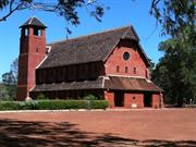
Fairbridge Rd Fairbridge
consists of: Church of the Holy Innocents & Graveyard; rectory; school house and classrooms/training rooms; laundry; pump house; staff quarters/dining room/kitchen; bakehouse; cottages (see CP for names); Principal & Asst Principal houses; dairy & dairyman's house; engineer's house; farm manager's house; office; men's quarters; refrigerator room; Scratton Memorial
Fairbridge Village
Murray
Peel
Constructed from 1920 to 1950
| Type | Status | Date | Documents |
|---|---|---|---|
| Heritage List | Adopted | ||
| State Register | Registered | 02 Jun 1998 | HCWebsite.Listing+ListingDocument, HCWebsite.Listing+ListingDocument |
| Type | Status | Date | Documents |
|---|---|---|---|
| (no listings) |
| Type | Status | Date | Grading/Management | |
|---|---|---|---|---|
| Category | ||||
| Local Heritage Survey | Adopted | 26 Mar 2020 | Category A | |
| Art Deco Significant Bldg Survey | Completed | |||
| Aboriginal Heritage Sites Register | Permanent | |||
| Restrictive Covenant | YES | |||
| Aboriginal Heritage Sites Register | Recorded | |||
| Register of the National Estate | Registered | 27 Oct 1998 | ||
| Classified by the National Trust | Classified | 04 Jul 1977 | ||
| Name | Type | Year From | Year To |
|---|---|---|---|
| Powell, Cameron & Chisholm | Architect | - | - |
| Sir Herbert Baker | Architect | - | - |
| Library Id | Title | Medium | Year Of Publication |
|---|---|---|---|
| 5446 | Report to Alcoa : Fairbridge Village Feasibility Study. | Report | 1996 |
| 7154 | The Fairbridge chapel : Sir Herbert Baker's labour of love. | Book | 2004 |
| 3796 | Former Fairbridge Farm School : conservation plan. Volumes 1 & 2. | Heritage Study {Cons'n Plan} | 1998 |
| 7257 | Good enough never is : lessons from inspirational businesses in rural Australia : a report for the Rural Industries Research and Development Corporation. | Book | 2005 |
| 2106 | Bibliography of 16mm film produced in Western Australia to 1950 from the State Film Archives of Western Australia : Vol. 2. Government and Fairbridge collections. | Book | 1993 |
| 5516 | Reroofing workshop at Fairbridge Village. | Conservation works report | 2002 |
| 7265 | Exeter Fairbridge : conservation works. | Conservation works report | 2005 |
| 9409 | Photographic record for Jenner Cottage former Fairbridge Farm School, Pinjarra. | Heritage Study {Other} | 2009 |
| 5440 | Fairbridge : style manual. | Report | 2002 |
| 9466 | Signposts: a guide for children and young people in care in WA from 1920. | Electronic | 2010 |
| 8305 | The story of Kingsley Fairbridge by himself. | Book | 1945 |
| 5439 | Fairbridge Village : interpretation plan. | Heritage Study {Other} | 2002 |
| 11672 | Fairbridge Chapel, Fairbridge | Archival Record | 2018 |
| 4023 | Fairbridge : Empire and child migration. | Book | 1998 |
Individual Building or Group
| Epoch | General | Specific |
|---|---|---|
| Original Use | RELIGIOUS | Housing or Quarters |
| Original Use | RELIGIOUS | Church, Cathedral or Chapel |
| Original Use | EDUCATIONAL | Special School |
| Present Use | SOCIAL\RECREATIONAL | Other Community Hall\Centre |
| Style |
|---|
| Inter-War Old English |
| Type | General | Specific |
|---|---|---|
| Roof | TIMBER | Shingle |
| Wall | RENDER | Other Render |
| Wall | EARTH | Pise {Rammed Earth} |
| Wall | BRICK | Common Brick |
| General | Specific |
|---|---|
| SOCIAL & CIVIC ACTIVITIES | Education & science |
| DEMOGRAPHIC SETTLEMENT & MOBILITY | Immigration, emigration & refugees |
| SOCIAL & CIVIC ACTIVITIES | Religion |
| OUTSIDE INFLUENCES | Depression & boom |
| DEMOGRAPHIC SETTLEMENT & MOBILITY | Settlements |
| OCCUPATIONS | Grazing, pastoralism & dairying |
This information is provided voluntarily as a public service. The information provided is made available in good faith and is derived from sources believed to be reliable and accurate. However, the information is provided solely on the basis that readers will be responsible for making their own assessment of the matters discussed herein and are advised to verify all relevant representations, statements and information.
Constructed from 1920
The Church of the Holy Innocents, Fairbridge House and the Old Fairbridgians Clubhouse have high cultural heritage significance in their own right. Fairbridge Village is an excellent example of the use of the Inter-War Old English architectural style. Fairbridge Village was the first of a number of similar institutions established by the Child Emigration Society and is the only remaining site where tangible evidence remains to illustrate how the institution was organised. Fairbridge Village is important for its associations with Kingsley and Ruby Fairbridge, Sir Herbert Baker, who designed the Church of the Holy Innocents, and for its associations with the architectural firm Powell, Cameron and Chisholm. Fairbridge Village has a high level of significance to members of the Old Fairbridgians' Association who continue an active involvement with the place.
The majority of buildings at Fairbridge Village are of timber frame construction with weatherboard cladding to the external walls. They were constructed with either sheoak shingles or corrugated iron roofs. Chimneys and fireplaces were generally face red brick. Internal wall linings were of vertical timber panelling to dado height with battened plasterboard above and to ceilings. Timber framed windows were mainly pairs of small paned casements. The principal residences, Heath and Fairbridge House, were of masonry and pise construction to first floor level respectively with half timbering used for the upper storey. Generally the buildings can be described as being in the Inter-War Old English style. This style is distinguished by the use of the visual attributes of English rural architecture including half timbering, small-paned casement windows, shingled roofs, tall chimneys and textured brickwork. Generally the two-storey buildings at Fairbridge Village reflect this style, while the singlestorey cottages were closer to the Western Australian vernacular architecture of the period. The main exceptions are the Old Fairbridgians Clubhouse and Church of the Holy Innocents. The Clubhouse is distinguished by the prominent Dutch gable on the front elevation of the building. The church is unusual in its style and scale using an unusual combination of elements including round arched openings, together with prominent steeply pitched shingled roofs.
Fairbridge Village is a former children’s home developed on the cottage accommodation model. Cottage homes for orphaned children were well known in Australia, and the concept had been utilised by the Salvation Army in Collie and by the Anglican Sisterhood at the Parkerville Home. However, Fairbridge Village brought the planning and building of cottage homes to a new level, one of self-supporting village, a model copied in other States. The following chronology summarises the key events in the construction of Fairbridge Village: - 1909 Kingsley Fairbridge founds Child Emigration Society in Oxford - 1912 Kingsley and Ruby Fairbridge open Fairbridge House, Blythewood - 1918 Establishment Children's Farm School Immigration Society of WA 1920 3,000 acres of Creaton Estate purchased for new farm school site - 1921 Five cottages, kitchen and store completed - 1922 Fairbridge House completed - 1922 Four classrooms constructed. - 1923 Eight more cottages completed - 1924 Kingsley Fairbridge dies - 1927 Seven more cottages; visit of Duke and Duchess of York - 1928 Principal’s Residence constructed - 1932 Church of the Holy Innocents completed; golf course begun - 1933 Old Fairbridgians Clubhouse completed - 1934 Concrete weir constructed across river to provide a swimming hole - 1935 Arthur Scratton Memorial residential building completed; Domestic Science building constructed - 1938 Staff dining room, kitchen and quarters constructed. - 1948 Renovations on site begin - 1949 First British migrant children arrive after WWII - 1950 School buildings renovated - 1954 Renovations to eighteen cottages completed - 1961 Big Brother Movement began to utilise Fairbridge; plans for new swimming pool, oval and sports pavilion completed - 1964 Visit of Queen Mother - 1965 Barnardo children stop arriving in Australia - 1973 Government restricts immigration - 1981 Fairbridge Farm School closed - 1983 Alcoa purchase site and erect memorial over Fairbridge's grave - 1989 Fairbridge WA lease the site for 44 years on a peppercorn rent - 2019 Major conservation works to Fairbridge Chapel including removal of shingles and replacement with welsh slate; demolition of Lister Cottage
High
Good
| Ref ID No | Ref Name | Ref Source | Ref Date |
|---|---|---|---|
| Heritage & Conservation Proffessionals 'Former Fairbridge Farm School Conservation Plan' | 1997 |
| Reserve | Lot/Location | Plan/Diagram | Vol/Folio |
|---|---|---|---|
| Lot 4 |
| Owner | Category |
|---|---|
| Alcoa of Australia Ltd. | Other Private |
| Fairbridge Western Australia (Inc.) | Inc. Non-profit body |
This information is provided voluntarily as a public service. The information provided is made available in good faith and is derived from sources believed to be reliable and accurate. However, the information is provided solely on the basis that readers will be responsible for making their own assessment of the matters discussed herein and are advised to verify all relevant representations, statements and information.
Fairbridge Rd Fairbridge
southern side approximately 2km from South Western Highway
Pinjarra North
Murray
Peel
Constructed from 1940
| Type | Status | Date | Documents |
|---|---|---|---|
| (no listings) |
| Type | Status | Date | Documents |
|---|---|---|---|
| (no listings) |
| Type | Status | Date | Grading/Management | |
|---|---|---|---|---|
| Category | ||||
| Municipal Inventory | Adopted | 25 Aug 2011 | Category D | |
Historic site
| Epoch | General | Specific |
|---|---|---|
| Present Use | Transport\Communications | Air: Other |
| Original Use | Transport\Communications | Air: Other |
| General | Specific |
|---|---|
| TRANSPORT & COMMUNICATIONS | Air transport |
This information is provided voluntarily as a public service. The information provided is made available in good faith and is derived from sources believed to be reliable and accurate. However, the information is provided solely on the basis that readers will be responsible for making their own assessment of the matters discussed herein and are advised to verify all relevant representations, statements and information.
Constructed from 1942
WWII Airfield has historic significance through the role the site played in Western Australia’s contribution to the war efforts in World War II.
Sealed strip, now overgrown in paddock. Part of what was once the airstrip now an access track. At the southern end stands a livestock holding pen and loading facilities; at the northern end is a loading ramp. Now disused. One strip was located on Lot 39 Fairbridge Road, whilst the other strip ran in a north-east to south-west direction immediately west of South-Western Highway. Several underground fuel tanks, including one east of the Pinjarra Railway Station (near Racecourse Road).
Was considered a major airfield with two main landing strips plus taxiing ways. Played an important role in the military history of the State. The decision to construct the airstrip was made in March 1942 after the bombing of Broome. It was to serve as a satellite airfield should the main airbase at Pearce be attacked.
Site Only
Site Only
| Ref ID No | Ref Name | Ref Source | Ref Date |
|---|---|---|---|
| Richard, R. "Murray and Mandurah" | Shire of Murray and City of Mandurah | 1993 |
| Ref Number | Description |
|---|---|
| 027 | Municipal Inventory |
| Reserve | Lot/Location | Plan/Diagram | Vol/Folio |
|---|---|---|---|
| Lot 39 |
This information is provided voluntarily as a public service. The information provided is made available in good faith and is derived from sources believed to be reliable and accurate. However, the information is provided solely on the basis that readers will be responsible for making their own assessment of the matters discussed herein and are advised to verify all relevant representations, statements and information.
Pipeline Rd Fairbridge
Lot 2464 on D 9545
Murray
Peel
| Type | Status | Date | Documents |
|---|---|---|---|
| Heritage List | Adopted |
| Type | Status | Date | Documents |
|---|---|---|---|
| (no listings) |
| Type | Status | Date | Grading/Management | |
|---|---|---|---|---|
| Category | ||||
| (no listings) | ||||
Historic Site
This information is provided voluntarily as a public service. The information provided is made available in good faith and is derived from sources believed to be reliable and accurate. However, the information is provided solely on the basis that readers will be responsible for making their own assessment of the matters discussed herein and are advised to verify all relevant representations, statements and information.
This information is provided voluntarily as a public service. The information provided is made available in good faith and is derived from sources believed to be reliable and accurate. However, the information is provided solely on the basis that readers will be responsible for making their own assessment of the matters discussed herein and are advised to verify all relevant representations, statements and information.
Cnr Old Coast Rd & Melita St Falcon
Murray
Peel
| Type | Status | Date | Documents |
|---|---|---|---|
| (no listings) |
| Type | Status | Date | Documents |
|---|---|---|---|
| (no listings) |
| Type | Status | Date | Grading/Management | |
|---|---|---|---|---|
| Category | ||||
| Municipal Inventory | Adopted | 05 Aug 1997 | Category 6 | |
Noted as demolished on 1999 MI
Individual Building or Group
| Epoch | General | Specific |
|---|---|---|
| Present Use | RESIDENTIAL | Single storey residence |
| Original Use | RESIDENTIAL | Single storey residence |
This information is provided voluntarily as a public service. The information provided is made available in good faith and is derived from sources believed to be reliable and accurate. However, the information is provided solely on the basis that readers will be responsible for making their own assessment of the matters discussed herein and are advised to verify all relevant representations, statements and information.
Constructed from 1890
The cottage was a typical example of many old homes of the late 19th century. It was constructed of limestone, with wooden floors, a large open fireplace and had a square, simple design. It was owned by prominent members of Mandurah’s fishing and water transport industries.
Limestone from the cottage was used by Falcon residents to restore the Falcon Stock Well.
Cox’s cottage is associated with the Cox brothers, Joseph and William, who were attracted to Mandurah in the 1890s by its fish canning industry. Captain Joseph Cox was well-known in Mandurah and transported goods to and from Fremantle in his boat, Seagull.
| Ref ID No | Ref Name | Ref Source | Ref Date |
|---|---|---|---|
| Ronald Richards "Mandurah and the Murray: a sequel to the history of the old Murray District of Western Australia" | Shire of Murray and City of Mandurah | 1993 |
This information is provided voluntarily as a public service. The information provided is made available in good faith and is derived from sources believed to be reliable and accurate. However, the information is provided solely on the basis that readers will be responsible for making their own assessment of the matters discussed herein and are advised to verify all relevant representations, statements and information.
This information is provided voluntarily as a public service. The information provided is made available in good faith and is derived from sources believed to be reliable and accurate. However, the information is provided solely on the basis that readers will be responsible for making their own assessment of the matters discussed herein and are advised to verify all relevant representations, statements and information.
Jarrahdale
Murray
Peel
| Type | Status | Date | Documents |
|---|---|---|---|
| (no listings) |
| Type | Status | Date | Documents |
|---|---|---|---|
| (no listings) |
| Type | Status | Date | Grading/Management | |
|---|---|---|---|---|
| Category | ||||
| (no listings) | ||||
Historic site
| Epoch | General | Specific |
|---|---|---|
| Original Use | FORESTRY | Other |
This information is provided voluntarily as a public service. The information provided is made available in good faith and is derived from sources believed to be reliable and accurate. However, the information is provided solely on the basis that readers will be responsible for making their own assessment of the matters discussed herein and are advised to verify all relevant representations, statements and information.
Mandurah
The Goegrup Lakes System is a large area and located in Mandurah and Murray LGAs
Serpentine River Wetlands
Willy's Lake (Aboriginal name) / Geogrup (MI)
Murray
Peel
| Type | Status | Date | Documents |
|---|---|---|---|
| (no listings) |
| Type | Status | Date | Documents |
|---|---|---|---|
| RHP - To be assessed | Current | 28 Nov 2008 |
| Type | Status | Date | Grading/Management | |
|---|---|---|---|---|
| Category | ||||
| Municipal Inventory | Adopted | 27 May 2014 | Category 1 | |
| Register of the National Estate | Indicative Place | |||
· The place has historic and social value to the Nyungah who have occupied the southwest of Western Australia for thousands of years.
· The place has historic value because it is a site where important events played out between the Nyungah and Europeans leading to the massacre / battle of Pinjarra.
· The place has historic importance to the development of the Swan River and Peel settlements because the water from the lake system was used in the construction of major roads connecting the region to Fremantle and to Perth and for horses to drink before motor transport.
· The place has historic value with the development of agriculture to the region where the Geogrup Lakes System was used as an important water source for livestock.
· The place holds aesthetic and scientific value for number of groups including government, school and conservation groups that use the area for ecological study purposes
· The place is socially important to a number of people who still use the Geogrup Lakes System for recreational purposes.
· The integrity and condition of the Geogrup Lakes System are representative of a place that has strong associations with humans interacting with the natural environment. This is illustrated with various important Aboriginal sites in the area; infrastructure with roads, bridges, farms and housing; previous pollution problems and the clearing of vegetation.
The Geogrup Lakes System also known as Willy’s Lake is a large open shallow wetland (max depth approx 1.5 metres) covering 1700ha containing native vegetation along its banks, riparian salt marches, streams and small islands situated in a scenic river valley. Albout 1700 ha, 50km to 65 km S of Perth, comprising the lower reaches of the Serpentine River & inc that portion of the river system that is composed of channels & open water bodies such as the Goegrup Lakes Chain, Yalbunberup Pool, Amarillo Pool & Guananup Pool & their surrounds.
Geogrup Lake was a traditional camping area where Aboriginal people constructed fish traps at the narrow ends of the creeks and engaged in traditional practices. It was also a place where European settlers and the Nyungah interacted. There was a particular violent incident involving the murder of an early settler George McKenzie who was speared near the lake. It has been suggested that this incident as well as other violent encounters ultimately prompted Governor Stirling’s decision to act at the ‘Massacre of Pinjarra’ on the 28th of October 1834.
Landscape
| Epoch | General | Specific |
|---|---|---|
| Present Use | OTHER | Other |
| Original Use | OTHER | Other |
| General | Specific |
|---|---|
| SOCIAL & CIVIC ACTIVITIES | Sport, recreation & entertainment |
| DEMOGRAPHIC SETTLEMENT & MOBILITY | Aboriginal Occupation |
This information is provided voluntarily as a public service. The information provided is made available in good faith and is derived from sources believed to be reliable and accurate. However, the information is provided solely on the basis that readers will be responsible for making their own assessment of the matters discussed herein and are advised to verify all relevant representations, statements and information.
The lake has abundant wildlife and plant life within and around its banks. It is thought to have a substantial number of significant Aboriginal sites nearby. It is a contested area; an area with significant conservation value and also facing increasing pressure from urban settlement.
A large open shallow wetland with a maximum depth of 1.5m and extensive riparian salt marshes. The lake has been classed as a seasonally inundated basin (sump land) and has high conservation management status.
It is a permanent wetland formed approximately 10000 years ago. It was highly significant to local Aboriginals as a place with significant resources in and around the lake. The richness of the lake as a resource led to conflict between the local Aboriginal people and white European settlers.
| Ref ID No | Ref Name | Ref Source | Ref Date |
|---|---|---|---|
| Register of the National Estate Database 017281 | |||
| Draft Serpentine River Management Plan | Murdoch University for Water and Rivers Commission | 1998 |
| Owner | Category |
|---|---|
| City of Mandurah | Local Gov't |
This information is provided voluntarily as a public service. The information provided is made available in good faith and is derived from sources believed to be reliable and accurate. However, the information is provided solely on the basis that readers will be responsible for making their own assessment of the matters discussed herein and are advised to verify all relevant representations, statements and information.
Peel Inlet Mandurah
Unallocated Crown Land
Mandurah
Peel
| Type | Status | Date | Documents |
|---|---|---|---|
| (no listings) |
| Type | Status | Date | Documents |
|---|---|---|---|
| RHP - Does not warrant assessment | Current | 19 Dec 2008 |
| Type | Status | Date | Grading/Management | |
|---|---|---|---|---|
| Category | ||||
| Municipal Inventory | Adopted | 27 May 2014 | Category 1 | |
| Register of the National Estate | Permanent | 15 May 1990 | ||
Large Conservation Region
| Epoch | General | Specific |
|---|---|---|
| Original Use | PARK\RESERVE | Park\Reserve |
| Present Use | PARK\RESERVE | Park\Reserve |
| General | Specific |
|---|---|
| DEMOGRAPHIC SETTLEMENT & MOBILITY | Settlements |
| TRANSPORT & COMMUNICATIONS | River & sea transport |
| DEMOGRAPHIC SETTLEMENT & MOBILITY | Aboriginal Occupation |
| SOCIAL & CIVIC ACTIVITIES | Sport, recreation & entertainment |
This information is provided voluntarily as a public service. The information provided is made available in good faith and is derived from sources believed to be reliable and accurate. However, the information is provided solely on the basis that readers will be responsible for making their own assessment of the matters discussed herein and are advised to verify all relevant representations, statements and information.
Extremely important as bird habitats. The area provides the most important estuarine bird habitat in south west Western Australia. Seventy species of bird have been recorded there including sixteen migratory species protected by international migratory bird treaties. The samphire flats and wetlands of the area support a considerable diversity of invertebrate fauna. There are thirty seven species of fish that are supported by the estuary and are an important food source for birdlife, but also have significant importance for commercial and recreational fishing. The vegetation along the banks is representative types that were once more extensive on the coastal plain.
The system is the largest estuarine ecosystem of the Swan Coastal plain.
The estuary has been a major source of food for both Aboriginal people and the early settlers. Aboriginal people gathered around the estuary tributaries at their mungahs for many years and during the latter half of the nineteenth century a commercial fishing industry was established. The inlet was also highly valued as a place of recreation for both local residents and holidaymakers. Concern regarding eutrophication saw the Dawesville Channel being constructed between the ocean and the estuary in an attempt to flush out the estuary.
| Owner | Category |
|---|---|
| Department of Environment & Conservation (Formerly CALM) | State Gov't |
This information is provided voluntarily as a public service. The information provided is made available in good faith and is derived from sources believed to be reliable and accurate. However, the information is provided solely on the basis that readers will be responsible for making their own assessment of the matters discussed herein and are advised to verify all relevant representations, statements and information.
Forest Block No 23 Marrinup
4 km North-West of Dwellingup, Marrinup
Murray
Peel
Constructed from 1943
| Type | Status | Date | Documents |
|---|---|---|---|
| Heritage List | Adopted | ||
| State Register | Registered | 04 Apr 1996 | HCWebsite.Listing+ListingDocument, HCWebsite.Listing+ListingDocument |
| Type | Status | Date | Documents |
|---|---|---|---|
| (no listings) |
| Type | Status | Date | Grading/Management | |
|---|---|---|---|---|
| Category | ||||
| Local Heritage Survey | Adopted | 26 Mar 2020 | Category A | |
| Register of the National Estate | Indicative Place | |||
Historic Site
| Epoch | General | Specific |
|---|---|---|
| Present Use | GOVERNMENTAL | Other |
| Original Use | GOVERNMENTAL | Other |
| Style |
|---|
| Other Style |
| Type | General | Specific |
|---|---|---|
| Wall | TIMBER | Other Timber |
| General | Specific |
|---|---|
| OUTSIDE INFLUENCES | World Wars & other wars |
This information is provided voluntarily as a public service. The information provided is made available in good faith and is derived from sources believed to be reliable and accurate. However, the information is provided solely on the basis that readers will be responsible for making their own assessment of the matters discussed herein and are advised to verify all relevant representations, statements and information.
Constructed from 1943
Marrinup POW Camp is the only example of a permanent specialised WWII camp constructed in Western Australia. There has been minimal development of the site for the archaeological record is still intact. Marrinup POW Camp is significant as evidence of the impact of WWII on Western Australia, Marrinup POW Camp is associated with the hundreds of men, from both the German and Italian communities, who were prisoners there.
Concrete, retained earth, large tree stumps. Foundations only - no structures. Remains of camp include: masonry foundations; concrete and retained earth foundations; latrines; garden terraces; ornamental gardens, edging, paths; fence lines and drains; tree stump which was used as base for guard towers; refuse features; bridges and stumps.
Officially called No. 16 POW Camp, Marrinup, the place was commenced in August 1943 as part of the ‘Rural Employment Without Guards Scheme’ to alleviate labour shortages. This camp was the headquarters of the Scheme in Western Australia, and was responsible for the allocation/relocation of internees to other parts of the South-West for farm placement. As per the Geneva Convention, prisoners were employed in non-war related work, such as chopping wood for hospitals, etc. Many of those interned were male residents from Harvey and Waroona, which had large Italian populations. Some immigrants had previously applied for Australian Citizenship, thus avoiding being interned. The prisoners were popular with the local people, and it has been said that some of the ‘enemy’ could be found drinking with at the Dwellingup Hotel. The Camp was enlarged in July 1944 to include an additional two guard towers. The place was closed in August 1946 and dismantled in September 1946. In the early 21st century, interpretive signage was installed by the Department of Environment and Conservation.
High
Good (as site)
| Ref ID No | Ref Name | Ref Source | Ref Date |
|---|---|---|---|
| Heritage Council of WA Assessment | Marrinup Prisoner of War Camp |
| Ref Number | Description |
|---|---|
| 037 | Municipal Inventory |
| Reserve | Lot/Location | Plan/Diagram | Vol/Folio |
|---|---|---|---|
| Forest Block 23 |
| Owner | Category |
|---|---|
| Dept of Conservation and Land Management | State Gov't |
This information is provided voluntarily as a public service. The information provided is made available in good faith and is derived from sources believed to be reliable and accurate. However, the information is provided solely on the basis that readers will be responsible for making their own assessment of the matters discussed herein and are advised to verify all relevant representations, statements and information.
End of Grey Rd Marrinup
Murray
Peel
| Type | Status | Date | Documents |
|---|---|---|---|
| Heritage List | Adopted |
| Type | Status | Date | Documents |
|---|---|---|---|
| (no listings) |
| Type | Status | Date | Grading/Management | |
|---|---|---|---|---|
| Category | ||||
| Local Heritage Survey | Adopted | 26 Mar 2020 | Category B | |
Historic Town or district
| Epoch | General | Specific |
|---|---|---|
| Present Use | VACANT\UNUSED | Vacant\Unused |
| Original Use | COMMERCIAL | Other |
| General | Specific |
|---|---|
| OCCUPATIONS | Timber industry |
This information is provided voluntarily as a public service. The information provided is made available in good faith and is derived from sources believed to be reliable and accurate. However, the information is provided solely on the basis that readers will be responsible for making their own assessment of the matters discussed herein and are advised to verify all relevant representations, statements and information.
Constructed from 1910
Marrinup Townsite (ruins) has significance as the historical site of a mill town, which were once central to the economy of the Dwellingup area.
Remains of mill town
In 1902 a horse-drawn tramway was constructed from Pinjarra to serve a sawmill at Marrinup. This line operated for about two years. The Western Australian Government Railways (WAGR) followed the alignment of this tramway when they constructed the line to Dwellingup which opened in 1910. Marrinup was the only community of any consequence between Pinjarra and Dwellingup. Millars operated a sizeable mill for varying periods between 1910 and 1930 on the north bank of Marrinup Brook. A number of weatherboard and corrugated iron houses were located at the townsite, along with a company general store. Some of the residences are still extant, having been relocated after the closing of the mill. After Millars erected the mill in 1910, there were soon 25 school-age children in the accompanying town. The Education Department proposed a ‘tent school’, but Millars supplied timber at cost price and a building was erected. Marrinup School was completed by May 1911, although it did not open until 12 November that year, with Mr G. Watson Brown as the first teacher. This building is now used as RSL Hall, Dwellingup. After 1930, the townsite appears to have been deserted. The site is currently managed by the Department of Biosecurity, Conservation and Attractions as a public camping ground (2019).
Site only
Site only
| Ref ID No | Ref Name | Ref Source | Ref Date |
|---|---|---|---|
| Richards, Ronald 'Murray and Mandurah' | Shire of Murray & City of Mandurah | 1993 |
This information is provided voluntarily as a public service. The information provided is made available in good faith and is derived from sources believed to be reliable and accurate. However, the information is provided solely on the basis that readers will be responsible for making their own assessment of the matters discussed herein and are advised to verify all relevant representations, statements and information.
545 Coolup Rd East Meelon
Lot 21, Cnr Coolup Rd East & Burnside Rd
Murray
Peel
Constructed from 1860
| Type | Status | Date | Documents |
|---|---|---|---|
| Heritage List | Adopted |
| Type | Status | Date | Documents |
|---|---|---|---|
| RHP - To be assessed | Current | 25 Jan 2006 |
| Type | Status | Date | Grading/Management | |
|---|---|---|---|---|
| Category | ||||
| Local Heritage Survey | Adopted | 26 Mar 2020 | Category B | |
The place is rare as an early colonial Homestead in the Peel Region in Western Australia.
The place is associated with the settlement and development of the Peel Region.
The place has the potential to yield scientific information as an early example of building techniques used in the 1860s.
The place is representative of a number of family farms established throughout Western Australia from the 1850s.
The place contributes to the community’s sense of place.
Burnside homestead comprises; A main residence/homestead (high pitched broken back roof) Gardeners cottage, Original caretakers cottage Blacksmith shed New double brick steel shed Other ancillary buildings for housing animals and stores. The buildings are not visible from the road and are set back with a eucalypt lined formal driveway entry. The homestead is set on the Banks of Tea Tree Brook.
‘Originally the residence of the Murray family, originally from Scotland, who first settled in the area in the 1840s. Both David Smythe Murray and his eldest son, John Gray Murray, served as Resident Magistrate and George Murray. Daivd Symthe Murray dies in 1864, but Burnside remained with the Murray family for the next 50 years.’ ‘The Murray family bought up parts of the surrounding countryside and leased huge acreages from the Crown at a small annual rental. They grazed sheep and cattle on their large runs, under the charge of Ticket-of-Leave convicts. They also successfully bred horses. The Murray family were a well-known and prosperous pioneering family of Pinjarra, especially in the Coolup / Meelon locality where they donated much of their time and money to support the local community facilities and activities and where Burnside was the social focus of the community.’ ‘In the mid 1910’s Burnside was left in the hands of the two surviving Murray sisters and although still remained a formidable property, a downward spiral was starting. In the 1920’s with the declining influence and prosperity of the Murray family with the Murray sisters having left Western Australia, Burnside was placed in the hands of managers who failed to keep the property viable. The property was auctioned in 1927 to clear the mortgage and purchased by a Mrs Hargreaves. Much of the Furniture and other artifacts of the Murray family were sold off at this time.’
Individual Building or Group
| Epoch | General | Specific |
|---|---|---|
| Original Use | RESIDENTIAL | Single storey residence |
| Present Use | RESIDENTIAL | Single storey residence |
| Style |
|---|
| Victorian Georgian |
| General | Specific |
|---|---|
| OCCUPATIONS | Grazing, pastoralism & dairying |
| DEMOGRAPHIC SETTLEMENT & MOBILITY | Land allocation & subdivision |
This information is provided voluntarily as a public service. The information provided is made available in good faith and is derived from sources believed to be reliable and accurate. However, the information is provided solely on the basis that readers will be responsible for making their own assessment of the matters discussed herein and are advised to verify all relevant representations, statements and information.
Constructed from 1860
Burnside Homestead is a significant and large early property in the Murray District and has high architectural value. Burnside Homestead is a significant early residence in the district, and is associated with David Smythe Murray, the resident magistrate. Burnside Homestead contributes to an understanding of the pattern of European settlement in the Murray District and is associated with the development of the dairying and agricultural industry in the area.
Burnside homestead comprises; - A main residence/homestead (high pitched broken back roof) - Gardeners cottage, - Original caretakers cottage - Blacksmith shed - New double brick steel shed - Ancillary buildings for housing animals and stores. The buildings are not visible from the road and are set back with a eucalypt lined formal driveway. The homestead is set on the Banks of Tea Tree Brook.
David Smythe Murray arrived in Western Australia, on board the Hero, in November 1835. He married Elizabeth Davis in September 1836, and their first child, Annie, was born in July 1837. Further children were named John, Elizabeth, Euphemie, Cecilia, David and George. The family moved from Fremantle to Mandurah in 1846, where Murray took up the post of Magistrate, succeeding Captain Singleton. In 1860, Murray purchased in the name of his son, John Gray Murray, for 40 acres of land where Burnside Homestead now stands. For this he paid £20. The application stated a house was already under construction. This residence was constructed of wattle and daub, with a rush roof, and was later destroyed by fire. Bricks for a new residence, and all outbuildings, were burnt in a kiln on the property; the timber was pit-swan; and, bolts were used, rather than nails, for securing the rafters. The walls were whitewashed. The house had fourteen rooms and a large cellar beneath the kitchen. In the 20th century (sometime after 1939), the kitchen was demolished, and the rubble used to fill in the cellar. From the outset, Burnside Homestead was intended as a ‘gentleman’s residence’ rather than a rural homestead. Murray lived in the property until his death on 3 February 1864, aged 56. John Gray succeeded his father as Resident Magistrate and held the office until 1883. The holdings were increased to several thousand acres, and the residence stocked with massive Victorian furniture. The land was used for Hereford and Aberdeen Angus cattle, thoroughbred horses, and Border Leicester sheep, as well as pigs and goats. Peacocks and swans were introduced for aesthetic reasons, and a vineyard introduced, with the wine made and stored in the cellars beneath Burnside Homestead. Aboriginal women were employed for treading the grapes. In 1893, Burnside Homestead was described as follows: Burnside is a very pretty place. The house, with its wide verandah, trailing creepers, and trim flower garden, has a very inviting appearance. One would hardly think it was the end, or nearly the end, of an Australian summer to see the many coloured blooms and bright greens of the pretty little garden. Everything about the place proclaims neatness and order, and a fondness on the part of these who live there for the amenities of country life. The vineyard is being gradually increased. This year, I am told, it is to be added to consider- ably. ... I had the pleasure of tasting the matured wine produced from this vineyard, and found it very agreeable. The orange trees at Burnside are very fine and add further testimony, if any were needed, to the suitability of the district to the citrus tribe. However, tragedy struck the family in 1901: Intelligence was received in Perth yesterday of the death, at 8 o'clock on Monday night of Mr. David Murray, of Burnside, Pinjarrah, at the age of 57 years. The announcement occasioned the deepest regret. This is the third death that has occurred in the Murray family almost within a week, the sister and brother of the deceased, Miss Frances Murray and Mr. George William Murray having both succumbed to measles on August 25. In 1908, the extent of the Murrays’ holdings were listed as: • Burnside Homestead: 740 acres of freehold and 2,405½ acres of Government leasehold. • Mowerinup: 6,606 acres of freehold, situated midway between Rockingham and Pinjarra. It had a small cottage, with 40 acres of land being cleared and fenced. • Foderans: 2,050 acres of freehold, about four miles from Burnside Homestead. In 1920, Miss Lizzie Murray returned to Scotland, and Burnside Homestead fell into a state of disrepair. For some years it was under quarantine, due to an infestation of star thistle. In 1927, the place was auctioned to clear the mortgage on the property. At the clearing sale, all the furniture and effects which the Murrays had acquired were sold. Family and official papers were apparently burned. At the auction, Burnside Homestead was purchased by Mrs Hargreaves and she undertook restoration works. It appears, however, by 1939 the place had yet again fallen into a state of disrepair. It was described by its new owner, Mrs F. Cook: [We] looked down at the big sprawling house, the long line of stables and cow sheds, the high brick barn, the brick dairy, the blacksmith’s shop, with its spiral chimney and the house where the hams were smoked. Mingled with the blue green of the gum trees, great spreading lilacs, acacias, pines, cypresses, poplars and kurrajongs trees were massed around the house... Across the road in another paddock were the woolshed, sheep dip and penning yards... [Inside the homestead, two] floors had been eaten by white ants, water had leaked through several spots in the ceilings, guttering and down pipes were rusted. Mrs Cook noted it was a ‘typical colonial house’, built of handmade bricks, painted white with a shingled roof. French doors opened onto long verdandahs. The jarrah floorboards still showed their hand-sawn origins, and the kitchen retained a large bread oven. The wine cellar under the kitchen was still extant in 1939. Mrs Cook undertook major renovations, including new plumbing, replacement flooring, cupboards, sinks and basins. One bedroom was converted into a bathroom and the verandah boards replaced. All rooms were painted in ‘pale ivory’. In 2010, extensive renovation and conservation works were undertaken, particularly to fix works completed in the 1930s and 1940s which had seen the removal of load bearing walls, causing the roof to sag. Major repairs to the wine cellar underneath the kitchen were completed at the same time. In 2019 conservation works to the blacksmith’s building are expected.
| Ref Number | Description |
|---|---|
| 039 | Municipal Inventory |
| Reserve | Lot/Location | Plan/Diagram | Vol/Folio |
|---|---|---|---|
| Lot 21 |
| Owner | Category |
|---|---|
| Phillip & Vivian McMullen | Other Private |
This information is provided voluntarily as a public service. The information provided is made available in good faith and is derived from sources believed to be reliable and accurate. However, the information is provided solely on the basis that readers will be responsible for making their own assessment of the matters discussed herein and are advised to verify all relevant representations, statements and information.
43 Kirkham Road Meelon
Kirkham House
Murray
Peel
| Type | Status | Date | Documents |
|---|---|---|---|
| Heritage List | Adopted |
| Type | Status | Date | Documents |
|---|---|---|---|
| (no listings) |
| Type | Status | Date | Grading/Management | |
|---|---|---|---|---|
| Category | ||||
| (no listings) | ||||
Individual Building or Group
| Epoch | General | Specific |
|---|---|---|
| Present Use | RESIDENTIAL | Single storey residence |
| Original Use | RESIDENTIAL | Single storey residence |
| Style |
|---|
| Federation Bungalow |
| Type | General | Specific |
|---|---|---|
| Wall | BRICK | Common Brick |
| Roof | METAL | Corrugated Iron |
This information is provided voluntarily as a public service. The information provided is made available in good faith and is derived from sources believed to be reliable and accurate. However, the information is provided solely on the basis that readers will be responsible for making their own assessment of the matters discussed herein and are advised to verify all relevant representations, statements and information.
Constructed from 1900
Riverdale is one of the earliest residences in the Coolup district and demonstrates a strong Federation architectural style, which is unusual in rural areas. Riverdale is associated with the Kirkham family, early and significant European settlers in the Coolup district.
Riverdale is a symmetrical Federation property, with two projecting gables and a verandah running the full width of the front façade. It is constructed of face bricks, said to have been made on site, and has a CGI roof and two prominent chimneys.
William and Anne Kirkham arrived in Albany, from England, in 1895. Shortly . after arrival they relocated to Coolup to establish a farm on 1,108 acres purchased from a Mr Berger. The family home, called Riverdale, was erected c.1900 with bricks made on the site. Anne Kirkham died in 1906, and William retired to Bassendean after 1916. The home, however, remained in family hands.
Good
Good
| Ref ID No | Ref Name | Ref Source | Ref Date |
|---|---|---|---|
| B. M. Gibbings & H. Madin, ‘Early Settlement in the Coolup District’ (c.1960) |
| Reserve | Lot/Location | Plan/Diagram | Vol/Folio |
|---|---|---|---|
| Lot 24 | 235002 | 1203/508 |
This information is provided voluntarily as a public service. The information provided is made available in good faith and is derived from sources believed to be reliable and accurate. However, the information is provided solely on the basis that readers will be responsible for making their own assessment of the matters discussed herein and are advised to verify all relevant representations, statements and information.
7 Murray Bend Dr Murray Bend
The Cooper Sisters' House
Yangee and Well
Murray
Peel
| Type | Status | Date | Documents |
|---|---|---|---|
| (no listings) |
| Type | Status | Date | Documents |
|---|---|---|---|
| (no listings) |
| Type | Status | Date | Grading/Management | |
|---|---|---|---|---|
| Category | ||||
| Local Heritage Survey | Adopted | 26 Mar 2020 | Category C | |
Individual Building or Group
| Epoch | General | Specific |
|---|---|---|
| Present Use | RESIDENTIAL | Single storey residence |
| Original Use | RESIDENTIAL | Single storey residence |
| Type | General | Specific |
|---|---|---|
| Wall | BRICK | Other Brick |
| Wall | TIMBER | Other Timber |
| Roof | METAL | Other Metal |
| General | Specific |
|---|---|
| DEMOGRAPHIC SETTLEMENT & MOBILITY | Settlements |
This information is provided voluntarily as a public service. The information provided is made available in good faith and is derived from sources believed to be reliable and accurate. However, the information is provided solely on the basis that readers will be responsible for making their own assessment of the matters discussed herein and are advised to verify all relevant representations, statements and information.
Constructed from 1890
Yangee is a representative weatherboard and iron cottage from the late 19th century.
A weatherboard and iron cottage, constructed c. 1890s. The lot on which the residence is situated abuts onto Murray River, with the house being located approximately 30 m from the river bank. The cottage features an unusual configuration of a four room frontage. The well is located in the south western corner of the property.
The cottage was built for the spinster sisters Mary Ann (d. 1946) and Rosa (d. 1950) Cooper, descendants of Joseph Cooper (Senior) of Redcliffe, Pinjarra. The rear of the property has been rebuilt in brick (c. 1960s).
Good
Fair
| Ref ID No | Ref Name | Ref Source | Ref Date |
|---|---|---|---|
| Fawcett, Glenys | "Historic Homes and Buildings od Pinjarra District, WA" Ravenswood Sanctuary | Date unknown. C.1995 |
| Ref Number | Description |
|---|---|
| 040 | Municipal Inventory |
| Reserve | Lot/Location | Plan/Diagram | Vol/Folio |
|---|---|---|---|
| Lot 3 |
This information is provided voluntarily as a public service. The information provided is made available in good faith and is derived from sources believed to be reliable and accurate. However, the information is provided solely on the basis that readers will be responsible for making their own assessment of the matters discussed herein and are advised to verify all relevant representations, statements and information.
Atkins Rd & South St North Dandalup
71 Atkins Rd, 71 Atkins RD, 24 South St, 26 South St & 28 South St
Murray
Peel
| Type | Status | Date | Documents |
|---|---|---|---|
| (no listings) |
| Type | Status | Date | Documents |
|---|---|---|---|
| (no listings) |
| Type | Status | Date | Grading/Management | |
|---|---|---|---|---|
| Category | ||||
| Municipal Inventory | Adopted | 25 Aug 2011 | Category C | |
Individual Building or Group
| Epoch | General | Specific |
|---|---|---|
| Original Use | Transport\Communications | Rail: Housing or Quarters |
| Present Use | RESIDENTIAL | Single storey residence |
| Type | General | Specific |
|---|---|---|
| Wall | ASBESTOS | Other Asbestos |
| Wall | METAL | Other Metal |
| Wall | TIMBER | Other Timber |
| Roof | METAL | Other Metal |
| General | Specific |
|---|---|
| TRANSPORT & COMMUNICATIONS | Rail & light rail transport |
This information is provided voluntarily as a public service. The information provided is made available in good faith and is derived from sources believed to be reliable and accurate. However, the information is provided solely on the basis that readers will be responsible for making their own assessment of the matters discussed herein and are advised to verify all relevant representations, statements and information.
Constructed from 1950, Constructed from 1910
Railway Houses, North Dandalup are associated with the railway line and station, and reflect the importance of rail transport in the history of the township.
Five residences in North Dandalup, from c. 1910's to the 1950's. Predominantly timber and iron cottages, they were constructed by the Railway Department for staff use.
The rail line reached North Dandalup in 1896, attracting new settlers and farmers to the area. Over the course of several decades from the 1910's, a number of residences were built by the Railway Department to accommodate railway workers. In 1924, the Stationmaster's house, called 'Station House', was built by Mr William Moir Doig (b. 1870, South Australia, d. 1946, Fremantle), and he relocated from Pinjarra to North Dandalup It has not yet been ascertained whether this is one of the extant properties. It is reported that a further residence was constructed in the 1950's, on Aitkins Road opposite the Dewar Road intersection (in the rail reserve). However, it appears that this structure has since been demolished.
1. High 2. High 3. High 4. Good 5. Good
1. Fair/good 2. Fair/good 3. Good/high 4. High 5. High
| Ref ID No | Ref Name | Ref Source | Ref Date |
|---|---|---|---|
| Sunday Times Newspaper | 18 May Issue | 1924 |
| Reserve | Lot/Location | Plan/Diagram | Vol/Folio |
|---|---|---|---|
| 2. Lot 280 | |||
| 3. Lot 3 | |||
| 1. Lot 280 | |||
| 4. Lot 2 | |||
| 5. Lot 33 |
This information is provided voluntarily as a public service. The information provided is made available in good faith and is derived from sources believed to be reliable and accurate. However, the information is provided solely on the basis that readers will be responsible for making their own assessment of the matters discussed herein and are advised to verify all relevant representations, statements and information.
Lot 1848 Hines Rd North Dandalup
Murray
Peel
| Type | Status | Date | Documents |
|---|---|---|---|
| (no listings) |
| Type | Status | Date | Documents |
|---|---|---|---|
| (no listings) |
| Type | Status | Date | Grading/Management | |
|---|---|---|---|---|
| Category | ||||
| Municipal Inventory | Adopted | 25 Aug 2011 | Category C | |
Individual Building or Group
| Epoch | General | Specific |
|---|---|---|
| Original Use | EDUCATIONAL | Primary School |
| Present Use | EDUCATIONAL | Primary School |
| General | Specific |
|---|---|
| SOCIAL & CIVIC ACTIVITIES | Education & science |
This information is provided voluntarily as a public service. The information provided is made available in good faith and is derived from sources believed to be reliable and accurate. However, the information is provided solely on the basis that readers will be responsible for making their own assessment of the matters discussed herein and are advised to verify all relevant representations, statements and information.
Constructed from 1952, Constructed from 1900
North Dandalup Primary School has been associated with the provision of education to children in the area since 1900. North Dandalup Primary School has social significance for former pupils, parents, and staff.
Main school buildings including the replacement 1952 building facing into a central court. Administration office, kindergarten, P&C rooms located north, with new library, undercover area and lawns to the east. Various artworks located around the grounds, as well as veggie patch, orchard and worm farm. Structures date from 1952 to 2010 and utilise various materials.
Original building constructed 1900, located in present day top car park. The building fell into disrepair in the 1940s and was later demolished and replaced in 1952. Site was donated by the Pollard family from their farm land holdings. The School has a multi-award winning biodiversity/heritage trail winding through the school.
Good
High
| Ref Number | Description |
|---|---|
| 032 | Municipal Inventory |
| Reserve | Lot/Location | Plan/Diagram | Vol/Folio |
|---|---|---|---|
| 5997 | Lot 1848 |
This information is provided voluntarily as a public service. The information provided is made available in good faith and is derived from sources believed to be reliable and accurate. However, the information is provided solely on the basis that readers will be responsible for making their own assessment of the matters discussed herein and are advised to verify all relevant representations, statements and information.
14 Kingston St North Dandalup
Murray
Peel
| Type | Status | Date | Documents |
|---|---|---|---|
| (no listings) |
| Type | Status | Date | Documents |
|---|---|---|---|
| (no listings) |
| Type | Status | Date | Grading/Management | |
|---|---|---|---|---|
| Category | ||||
| Municipal Inventory | Adopted | 25 Aug 2011 | Category C | |
Individual Building or Group
| Epoch | General | Specific |
|---|---|---|
| Original Use | RESIDENTIAL | Single storey residence |
| Present Use | RESIDENTIAL | Single storey residence |
| Type | General | Specific |
|---|---|---|
| Wall | TIMBER | Other Timber |
| Wall | OTHER | Other Material |
| Roof | METAL | Other Metal |
| General | Specific |
|---|---|
| DEMOGRAPHIC SETTLEMENT & MOBILITY | Settlements |
This information is provided voluntarily as a public service. The information provided is made available in good faith and is derived from sources believed to be reliable and accurate. However, the information is provided solely on the basis that readers will be responsible for making their own assessment of the matters discussed herein and are advised to verify all relevant representations, statements and information.
Constructed from 1948
Crockenberg's House is a representative fibro, weatherboard and iron residence demonstrating the simple construction of the post-war utility style. Crockenberg's House is associated with Ted Crockenberg, a significant figure in post-war North Dandalup.
Fibro, weatherboard and corrugated iron residence.
Frederick Herbert ('Ted') (d. 1970) Crockenberg and his wife Edith May ('Nell') (nee Nelson) (d. 1985) bought the vacant lot in 1948. Ted was third generation mill-worker, with his father and grandfather originally working at Banksiadale, and Ted for a time at Whittaker's Mill. During WWII, Ted ran the North Dandalup 'Alien's Camp' (where low risk Italians and Germans were sent after being processed at the Dwellingup POW camp). Nell worked as a nurse in Dwellingup. Ted would bring sick internees to the Dwellingup hospital, and while there, met his future wife. It is thought by some members of the Crockenberg family that a portion of the house was relocated from Whittaker's, although it is uncertain if this was the home the family inhabited at the Mill. In any event, Corckenberg House took three years to complete as building materials were in short supply post-war. The house/property itself was used for many commercial interests. From 1952, a car showroom ran from a large shed to the rear of the house. Ted sold new cars (Austin and Chrysler). Around 1957, Ted expanded and started a mechanical workshop, employing three different mechanics over the years until the workshop closed in 1969, prior to Ted's death in 1970. The property also acted as a transport depot, Ted carted wood, deliveries and agricultural products. Ted was also a 'Starting Price Bookmaker' or 'SP Bookie', an illicit bookmaker. He mainly operated from under the large tree outside of the North Dandalup Hotel (now Stud Country Tavern). He was arrested several times, and eventually ran the operation from his home. Ted ran for State Government, running for the seat of Murray as a Labour candidate during the 1960's. However, the seat was conservative, and he was unsuccessful. His daughter Cheryl Davenport, followed her father into politics, and was elected into the Upper House as the Labour member for the South Metropolitan electorate (1989-2001). After Nell's death in 1985, her son Malcolm Crockenberg took over the property and re-opened the workshop, operating an auto mechanics until 1991. The property was subdivided in 1991, with the house and main workshop remaining on one title. The current landowners, the Kunzels have owned the property since 1993.
High
Good
| Ref Number | Description |
|---|---|
| 028 | Municipal Inventory |
| Reserve | Lot/Location | Plan/Diagram | Vol/Folio |
|---|---|---|---|
| Lot 124 |
| Owner | Category |
|---|---|
| Mr & Mrs Kunzel | Other Private |
This information is provided voluntarily as a public service. The information provided is made available in good faith and is derived from sources believed to be reliable and accurate. However, the information is provided solely on the basis that readers will be responsible for making their own assessment of the matters discussed herein and are advised to verify all relevant representations, statements and information.
42 Railway Av North Dandalup
Murray
Peel
| Type | Status | Date | Documents |
|---|---|---|---|
| (no listings) |
| Type | Status | Date | Documents |
|---|---|---|---|
| (no listings) |
| Type | Status | Date | Grading/Management | |
|---|---|---|---|---|
| Category | ||||
| Municipal Inventory | Adopted | 25 Aug 2011 | Category D | |
Individual Building or Group
| Epoch | General | Specific |
|---|---|---|
| Original Use | RESIDENTIAL | Single storey residence |
| Present Use | RESIDENTIAL | Single storey residence |
| Type | General | Specific |
|---|---|---|
| Wall | TIMBER | Other Timber |
| Roof | METAL | Other Metal |
| General | Specific |
|---|---|
| DEMOGRAPHIC SETTLEMENT & MOBILITY | Settlements |
This information is provided voluntarily as a public service. The information provided is made available in good faith and is derived from sources believed to be reliable and accurate. However, the information is provided solely on the basis that readers will be responsible for making their own assessment of the matters discussed herein and are advised to verify all relevant representations, statements and information.
Constructed from 1922
Percy Matthews' House is representative of timber and iron cottages from the interwar period. Percy Matthews' House is associated with the returned soldiers housing scheme.
Timber and iron residence, with fibro extension to the rear.
Built under the returned soldiers housing scheme c. 1922 for William percy Matthews (born c. 1895, and known as Percy), son of James Matthews, and early settler to North Dandalup. Percy fought in both WWi and WWII, and the residence was built soon after he returned from war in 1919. Percy embarked from Fremantle, Western Australia, on board HMAT Port Melbourne on 30 October 1916. As part of the reinforcements for the 43rd Battalion, Percy would have partaken in bloody trench warfare in Flanders, the battle of the Messines and the Third Battle of Ypres. The house is now occupied by Percy's son, Geoff Matthews, and his wife, Merle.
Fair
Good
| Ref Number | Description |
|---|---|
| 033 | Municipal Inventory |
| Reserve | Lot/Location | Plan/Diagram | Vol/Folio |
|---|---|---|---|
| Lot 32 |
| Owner | Category |
|---|---|
| G & M Matthews | Other Private |
This information is provided voluntarily as a public service. The information provided is made available in good faith and is derived from sources believed to be reliable and accurate. However, the information is provided solely on the basis that readers will be responsible for making their own assessment of the matters discussed herein and are advised to verify all relevant representations, statements and information.
84 Railway Av North Dandalup
Murray
Peel
| Type | Status | Date | Documents |
|---|---|---|---|
| (no listings) |
| Type | Status | Date | Documents |
|---|---|---|---|
| (no listings) |
| Type | Status | Date | Grading/Management | |
|---|---|---|---|---|
| Category | ||||
| Municipal Inventory | Adopted | 25 Aug 2011 | Category C | |
Individual Building or Group
| Epoch | General | Specific |
|---|---|---|
| Present Use | RESIDENTIAL | Single storey residence |
| Original Use | RESIDENTIAL | Single storey residence |
| Type | General | Specific |
|---|---|---|
| Wall | TIMBER | Other Timber |
| Roof | TILE | Other Tile |
| General | Specific |
|---|---|
| DEMOGRAPHIC SETTLEMENT & MOBILITY | Settlements |
This information is provided voluntarily as a public service. The information provided is made available in good faith and is derived from sources believed to be reliable and accurate. However, the information is provided solely on the basis that readers will be responsible for making their own assessment of the matters discussed herein and are advised to verify all relevant representations, statements and information.
Constructed from 1926
George Matthews' House is representative of small worker's cottages constructed in the interwar period. George Matthews' House is associated with George Matthews, jockey on the 1917 Perth Cup winner, Downing Street.
Timber and tile residence, currently painted green.
Built c.1926 for £100 by George H. Matthews (born c1899), son of early North Dandalup settler, James Matthews. Currently occupied by George's son, Alan Douglas Matthews. As a jockey, George won the Perth Cup in record time in 1917, riding Downing Street. Trained by J.J. Kelly, Downing Street was owned by Geraldton identity, H. Gunner, and easily defeated the favourite, Irish Knight. George was later employed at Whittaker's Mill as a horse driver. He would drive the horses that pulled the felled trees. When the horses were retired, George was the first operator of the mechanical tractor from the Ford Corporation in the district. Prior to building George Matthews' House, George lived in one of the mill houses at Whittaker's with his wife, Ethel, and young children. It is thought that the residence was constructed by Mr. A. Brodribb, who also resided at North Dandalup.
Good
Good
| Ref ID No | Ref Name | Ref Source | Ref Date |
|---|---|---|---|
| Western mail Newspaper | 4 January Issue | 1918 | |
| West Australian Newspaper | 27 December issue | 1917 |
| Ref Number | Description |
|---|---|
| 029 | Municipal Inventory |
| Reserve | Lot/Location | Plan/Diagram | Vol/Folio |
|---|---|---|---|
| Lot 2 |
| Owner | Category |
|---|---|
| Alan Matthews | Other Private |
This information is provided voluntarily as a public service. The information provided is made available in good faith and is derived from sources believed to be reliable and accurate. However, the information is provided solely on the basis that readers will be responsible for making their own assessment of the matters discussed herein and are advised to verify all relevant representations, statements and information.
South Western Hwy North Dandalup
Murray
Peel
Constructed from 1850
| Type | Status | Date | Documents |
|---|---|---|---|
| (no listings) |
| Type | Status | Date | Documents |
|---|---|---|---|
| (no listings) |
| Type | Status | Date | Grading/Management | |
|---|---|---|---|---|
| Category | ||||
| (no listings) | ||||
Individual Building or Group
| Epoch | General | Specific |
|---|---|---|
| Original Use | FARMING\PASTORAL | Homestead |
| Present Use | FARMING\PASTORAL | Homestead |
| General | Specific |
|---|---|
| OCCUPATIONS | Grazing, pastoralism & dairying |
This information is provided voluntarily as a public service. The information provided is made available in good faith and is derived from sources believed to be reliable and accurate. However, the information is provided solely on the basis that readers will be responsible for making their own assessment of the matters discussed herein and are advised to verify all relevant representations, statements and information.
Lot 671 South Western Hwy North Dandalup
Murray
Peel
| Type | Status | Date | Documents |
|---|---|---|---|
| (no listings) |
| Type | Status | Date | Documents |
|---|---|---|---|
| (no listings) |
| Type | Status | Date | Grading/Management | |
|---|---|---|---|---|
| Category | ||||
| Municipal Inventory | Adopted | 25 Aug 2011 | Category C | |
Individual Building or Group
| Epoch | General | Specific |
|---|---|---|
| Original Use | SOCIAL\RECREATIONAL | Other Community Hall\Centre |
| Present Use | SOCIAL\RECREATIONAL | Other Community Hall\Centre |
| Type | General | Specific |
|---|---|---|
| Wall | BRICK | Other Brick |
| Roof | METAL | Other Metal |
| General | Specific |
|---|---|
| SOCIAL & CIVIC ACTIVITIES | Sport, recreation & entertainment |
This information is provided voluntarily as a public service. The information provided is made available in good faith and is derived from sources believed to be reliable and accurate. However, the information is provided solely on the basis that readers will be responsible for making their own assessment of the matters discussed herein and are advised to verify all relevant representations, statements and information.
Constructed from 1957
North Dandalup Memorial Hall has functioned as one of the centres of community activity in North Dandalup since 1957. North Dandalup Memorial Hall is associated with those citizens of the area who served in both World Wars. Dwellingup Mill is associated with the foundation of the Dwellingup townsite.
Brick and iron community hall, constructed in 1957. Various plaques are located within the Hall: 'Western Australia 150 years, North Dandalup 130 years, unveiled by Mr John Tonkin (Premier of Western Australia 1971-4) on September 15th 1979 to commemorate the 130th anniversary of the arrival of the first white settler, William Pollard, on the North Dandalup River'. 'Western Australia, North Dandalup 150 years, unveiled by Mr George Pollard descendant of the original pioneer on October 8th, 2000 to celebrate the sesquicentenary of settlement'. 'North Dandalup Memorial Hall - This hall was built by the citizens of North Dandalup & dedicated to the memory of those who gave their lives in the cause of freedom - Opened June 22nd 1957. The Hon. Sir John Ross McLarty KBE MM MLA'. 'North Dandalup Centenary: 1849 to 1949 - Unveiled by Mrs DR McLarty Granddaughter of the original Settler William Pollard at Mundup 8th October 1949'. There are also two honour boards of those who lost their lives in WWI and WWII from the North Dandalup and Keysbrook area. The North Dandalup Fire Brigade building was originally built onto the rear of the hall. The fire Brigade now has its own station building, though is on the same reserve to the north of the Hall.
North Dandalup Agricultural Hall was constructed c.1898 on the north corner of Church Street and Railway Avenue. After World War II, a local committee was formed to raise money to embark on a project to build North Dandalup Memorial Hall to replace the Agricultural Hall. There was a temporary setback when a storm blew down a portion of the brick walls while building was under way, on 22 June 1957 the hall was officially opened by the member for the district, Sir Ross McLarty. Fronting the South West Highway, Noth Dandalup Memorial Hall, is an imposing brick structure. A separate toilet block and power generator room was erected adjacent to the eastern side of the hall. Planning commenced in June 1987 to add a Bush Fire Station to the northern wall of the Hall. The plan also included the building of new toilet facilities. The extensions were opened on 3 October 1987. The original sash windows were changed for aluminium and were donated to Fairbridge for use in the upgrade of their buildings. In 1998, a patio was constructed to the rear of the Hall.
High
Good
| Ref Number | Description |
|---|---|
| 031 | Municipal Inventory |
| Reserve | Lot/Location | Plan/Diagram | Vol/Folio |
|---|---|---|---|
| R 15844 | Lot 671 |
This information is provided voluntarily as a public service. The information provided is made available in good faith and is derived from sources believed to be reliable and accurate. However, the information is provided solely on the basis that readers will be responsible for making their own assessment of the matters discussed herein and are advised to verify all relevant representations, statements and information.