Local Government
Murray
Region
Peel
South Western Hwy Pinjarra
REGISTERED AS PART OF 1762
Murray
Peel
| Type | Status | Date | Documents |
|---|---|---|---|
| (no listings) |
| Type | Status | Date | Documents |
|---|---|---|---|
| (no listings) |
| Type | Status | Date | Grading/Management | |
|---|---|---|---|---|
| Category | ||||
| Classified by the National Trust | Classified | 04 Jul 1977 | ||
| Register of the National Estate | Nominated | 19 Jul 1977 | ||
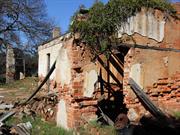
01762 Fairbridge Farm School (fmr)
| Library Id | Title | Medium | Year Of Publication |
|---|---|---|---|
| 4039 | Conservation Works to Saumerez Cottage Former Fairbridge Farm School Pinjarra | Heritage Study {Other} | 1999 |
Individual Building or Group
| Epoch | General | Specific |
|---|---|---|
| Present Use | FARMING\PASTORAL | Cottage |
| Original Use | FARMING\PASTORAL | Cottage |
This information is provided voluntarily as a public service. The information provided is made available in good faith and is derived from sources believed to be reliable and accurate. However, the information is provided solely on the basis that readers will be responsible for making their own assessment of the matters discussed herein and are advised to verify all relevant representations, statements and information.

South Western Hwy Pinjarra
Just upstream of the South West Hwy bridge South of Pinjarra traffic bridge
Murray River Weir
Murray
Peel
| Type | Status | Date | Documents |
|---|---|---|---|
| (no listings) |
| Type | Status | Date | Documents |
|---|---|---|---|
| (no listings) |
| Type | Status | Date | Grading/Management | |
|---|---|---|---|---|
| Category | ||||
| Municipal Inventory | Adopted | 29 Aug 2013 | Category D | |
Other Built Type
| Epoch | General | Specific |
|---|---|---|
| Present Use | GOVERNMENTAL | Reservoir or Dam |
| Original Use | GOVERNMENTAL | Reservoir or Dam |
| General | Specific |
|---|---|
| SOCIAL & CIVIC ACTIVITIES | Community services & utilities |
This information is provided voluntarily as a public service. The information provided is made available in good faith and is derived from sources believed to be reliable and accurate. However, the information is provided solely on the basis that readers will be responsible for making their own assessment of the matters discussed herein and are advised to verify all relevant representations, statements and information.
Constructed from 1895
Murray River Weir has historic significance as a unique part of a system to provide fresh water to Pinjarra.
Wall built across the Murray River about 1903, constructed from rocks and reinforced with timber. Can be accessed from Pioneer Memorial Park.
Only feature of its kind in the district. Located within the area of the Heritage Trail. Constructed to provide town water supply and prevent contamination by salt water.
High
Good
| Ref Number | Description |
|---|---|
| 057 | Municipal Inventory |
This information is provided voluntarily as a public service. The information provided is made available in good faith and is derived from sources believed to be reliable and accurate. However, the information is provided solely on the basis that readers will be responsible for making their own assessment of the matters discussed herein and are advised to verify all relevant representations, statements and information.
Cnr South Western Hwy & Greenlands Rd Pinjarra
Murray
Peel
| Type | Status | Date | Documents |
|---|---|---|---|
| (no listings) |
| Type | Status | Date | Documents |
|---|---|---|---|
| (no listings) |
| Type | Status | Date | Grading/Management | |
|---|---|---|---|---|
| Category | ||||
| (no listings) | ||||
Other Built Type
| Epoch | General | Specific |
|---|---|---|
| Present Use | MONUMENT\CEMETERY | Grave |
| Original Use | MONUMENT\CEMETERY | Grave |
This information is provided voluntarily as a public service. The information provided is made available in good faith and is derived from sources believed to be reliable and accurate. However, the information is provided solely on the basis that readers will be responsible for making their own assessment of the matters discussed herein and are advised to verify all relevant representations, statements and information.
Lot 9010 Sutton St Pinjarra
Cooper's Cottage
Murray
Peel
| Type | Status | Date | Documents |
|---|---|---|---|
| Heritage List | Adopted |
| Type | Status | Date | Documents |
|---|---|---|---|
| (no listings) |
| Type | Status | Date | Grading/Management | |
|---|---|---|---|---|
| Category | ||||
| Municipal Inventory | Adopted | 25 Aug 2011 | Category C | |
Individual Building or Group
| Epoch | General | Specific |
|---|---|---|
| Present Use | COMMERCIAL | Restaurant |
| Original Use | FARMING\PASTORAL | Shed or Barn |
| Type | General | Specific |
|---|---|---|
| Wall | BRICK | Other Brick |
| Roof | METAL | Other Metal |
| General | Specific |
|---|---|
| OCCUPATIONS | Rural industry & market gardening |
This information is provided voluntarily as a public service. The information provided is made available in good faith and is derived from sources believed to be reliable and accurate. However, the information is provided solely on the basis that readers will be responsible for making their own assessment of the matters discussed herein and are advised to verify all relevant representations, statements and information.
Redcliffe Barn is a good example of an early barn constructed of brick. Redcliffe Barn, Cottage & Well is associated with Joseph Cooper, who was the first European owner of the land, and who also constructed Cooper’s Mill.
Redcliffe Barn is constructed of locally burnt brick with a metal roof. The Cottage has timber cladding at the front facade with asbestos cladding at rear. The Well is thought to have been constructed in 1880, and now had a modern brick top.
Joseph Cooper arrived aboard the Warrior in 1830. With him were his wife, Elizabeth, and their children, Elizabeth, Rebecca, Joseph, and Mary Ann. By trade, Cooper was a wheelwright and blacksmith. After a period spent in Fremantle, in 1836 Cooper obtained location 13 in Pinjarra, where he established a farm he named Redcliffe. A house was built near the river and land quickly cleared. In 1843, Cooper began building a windmill at ‘Windmill Point’ (Cooleenup Island) at the mouth of the Murray River. He left the running of Redcliffe to his eldest son. Cooper died as a result of an accident in 1847. The date of construction of Redcliffe Barn has not been established, but it appears to be early. A weatherboard and asbestos cottage with a metal roof is also located on the same site. During the 1990s Redcliffe Barn was utilised as a small convenience store/café. In 2000, the Barn was converted into a bar and restaurant, with an outdoor roof extension added to the east in 2001, and addition for storage in 2006. Cooper’s Cottage was constructed in 1922 as the third Cooper family home. The cottage originally featured a detached kitchen with open fireplace and a separately detached bath house and toilet to the rear (now demolished). The Tuckey family renovated the cottage in 1971 which saw the installation of kitchen and bathroom facilities. Cooper’s Cottage was restored in 1998 by the developer of the surrounding land development and used as a craft shop and historical display relating to the Cooper family. The cottage is currently used as a private residence.
Fair
Good
| Ref ID No | Ref Name | Ref Source | Ref Date |
|---|---|---|---|
| Glenys Fawcett | Historic Homes and Building of Pinjarra District of WA, Ravenswood Sanctuary | ||
| Richards, Ronald. "The Murray District of Western Australia" | Shire of Murray | 1978 |
| Ref Number | Description |
|---|---|
| 075 | Municipal Inventory |
| Reserve | Lot/Location | Plan/Diagram | Vol/Folio |
|---|---|---|---|
| Lot 9010 (fmr Lots 13 & 9510) |
This information is provided voluntarily as a public service. The information provided is made available in good faith and is derived from sources believed to be reliable and accurate. However, the information is provided solely on the basis that readers will be responsible for making their own assessment of the matters discussed herein and are advised to verify all relevant representations, statements and information.
Williams Rd Pinjarra
Murray
Peel
| Type | Status | Date | Documents |
|---|---|---|---|
| (no listings) |
| Type | Status | Date | Documents |
|---|---|---|---|
| (no listings) |
| Type | Status | Date | Grading/Management | |
|---|---|---|---|---|
| Category | ||||
| (no listings) | ||||
Historic Site
| Epoch | General | Specific |
|---|---|---|
| Original Use | COMMERCIAL | Hotel, Tavern or Inn |
| Present Use | VACANT\UNUSED | Vacant\Unused |
| General | Specific |
|---|---|
| OCCUPATIONS | Hospitality industry & tourism |
This information is provided voluntarily as a public service. The information provided is made available in good faith and is derived from sources believed to be reliable and accurate. However, the information is provided solely on the basis that readers will be responsible for making their own assessment of the matters discussed herein and are advised to verify all relevant representations, statements and information.
Williams Rd Pinjarra
Murray
Peel
Constructed from 1865
| Type | Status | Date | Documents |
|---|---|---|---|
| (no listings) |
| Type | Status | Date | Documents |
|---|---|---|---|
| (no listings) |
| Type | Status | Date | Grading/Management | |
|---|---|---|---|---|
| Category | ||||
| (no listings) | ||||
Individual Building or Group
| Epoch | General | Specific |
|---|---|---|
| Present Use | INDUSTRIAL\MANUFACTURING | Flour Mill |
| Original Use | INDUSTRIAL\MANUFACTURING | Flour Mill |
| Type | General | Specific |
|---|---|---|
| Wall | BRICK | Handmade Brick |
| General | Specific |
|---|---|
| OCCUPATIONS | Manufacturing & processing |
This information is provided voluntarily as a public service. The information provided is made available in good faith and is derived from sources believed to be reliable and accurate. However, the information is provided solely on the basis that readers will be responsible for making their own assessment of the matters discussed herein and are advised to verify all relevant representations, statements and information.
Carrabungup Rd Point Grey
Murray
Peel
| Type | Status | Date | Documents |
|---|---|---|---|
| Heritage List | Adopted |
| Type | Status | Date | Documents |
|---|---|---|---|
| (no listings) |
| Type | Status | Date | Grading/Management | |
|---|---|---|---|---|
| Category | ||||
| Local Heritage Survey | Adopted | 26 Mar 2020 | Category B | |
Historic Site
| Epoch | General | Specific |
|---|---|---|
| Present Use | FARMING\PASTORAL | Homestead |
| Original Use | FARMING\PASTORAL | Homestead |
| General | Specific |
|---|---|
| OCCUPATIONS | Grazing, pastoralism & dairying |
This information is provided voluntarily as a public service. The information provided is made available in good faith and is derived from sources believed to be reliable and accurate. However, the information is provided solely on the basis that readers will be responsible for making their own assessment of the matters discussed herein and are advised to verify all relevant representations, statements and information.
Constructed from 1850
Culjum House has a high degree of value as, externally, it continues to demonstrate the appearance of an early homestead in the district. Culjum House is significant as an early farming homestead and is associated with the prominent Birch family.
A limestone residence.
The name 'Culjum' derives from the Aboriginal name for the areas surrounding Birchmont. Lewis Birch arrived on the Parkfield in 1841, and first settled at Australind. An apothecary, he moved to Perth and opened shops there and in Fremantle. Birch appears to have moved to the Murray District around 1845-46, and leased land from Peel. In 1850, he was granted 6,000 acres. He settled in the Culjum area, building his first homestead in an unsuitable spot (a low area subject to flood and sandflies) on Crown Grant 55. Realising the problems with this site, Birch decided to shift to a more suitable location a mile or so west, on Crown Grant 75, on which the present Culjum House is located. Dr Birch’s son, Arthur, also settled in the area, moving south to construct Birchmont Homestead.
Low
Good
| Ref ID No | Ref Name | Ref Source | Ref Date |
|---|---|---|---|
| Richards, Ronald 'The Murray District of Western Australia' | Shire of Murray | 1978 |
| Ref Number | Description |
|---|---|
| 083 | Municipal Inventory |
| Reserve | Lot/Location | Plan/Diagram | Vol/Folio |
|---|---|---|---|
| Lot 75 |
This information is provided voluntarily as a public service. The information provided is made available in good faith and is derived from sources believed to be reliable and accurate. However, the information is provided solely on the basis that readers will be responsible for making their own assessment of the matters discussed herein and are advised to verify all relevant representations, statements and information.
Ravenswood
Murray
Peel
| Type | Status | Date | Documents |
|---|---|---|---|
| (no listings) |
| Type | Status | Date | Documents |
|---|---|---|---|
| (no listings) |
| Type | Status | Date | Grading/Management | |
|---|---|---|---|---|
| Category | ||||
| (no listings) | ||||
Historic Site
| Epoch | General | Specific |
|---|---|---|
| Present Use | FARMING\PASTORAL | Homestead |
| Original Use | FARMING\PASTORAL | Homestead |
| General | Specific |
|---|---|
| OCCUPATIONS | Grazing, pastoralism & dairying |
This information is provided voluntarily as a public service. The information provided is made available in good faith and is derived from sources believed to be reliable and accurate. However, the information is provided solely on the basis that readers will be responsible for making their own assessment of the matters discussed herein and are advised to verify all relevant representations, statements and information.
32 Gibbs Cct Ravenswood
Pinjarra Road
Murray
Peel
| Type | Status | Date | Documents |
|---|---|---|---|
| Heritage List | Adopted |
| Type | Status | Date | Documents |
|---|---|---|---|
| (no listings) |
| Type | Status | Date | Grading/Management | |
|---|---|---|---|---|
| Category | ||||
| Municipal Inventory | Adopted | 29 Aug 2013 | Category B | |
Individual Building or Group
| Epoch | General | Specific |
|---|---|---|
| Original Use | FARMING\PASTORAL | Shed or Barn |
| Present Use | FARMING\PASTORAL | Shed or Barn |
| Type | General | Specific |
|---|---|---|
| Wall | BRICK | Other Brick |
| General | Specific |
|---|---|
| OCCUPATIONS | Grazing, pastoralism & dairying |
This information is provided voluntarily as a public service. The information provided is made available in good faith and is derived from sources believed to be reliable and accurate. However, the information is provided solely on the basis that readers will be responsible for making their own assessment of the matters discussed herein and are advised to verify all relevant representations, statements and information.
Ravenswood Barn is a fine example of an English style barn, and is characteristic of early European settlers’ farms. Ravenswood Barn is associated with Captain John Thomas, who is significant in the development of Ravenswood.
Large red brick construction - various types of bricks have been used at the front and side indicating reconstruction at some stage. Jarrah loft windows.
Part of the farm of Captain John Thomas (b. Wales, 1815, arr. WA 1829), who took up farming in the Kelmscott district where he was attacked by Yagan. He gave up farming shortly after to become a fisherman. He owned his own boat, the Emma, and, when this was wrecked, he built a larger schooner, the Empress. Thomas married Elizabeth (née Cooper) and they had seven children, who helped run the farming property at Ravenswood. He died in 1907. In 2009, Lot 6 was subdivided and a sales office was constructed adjacent to Ravenswood Barn. The office is to be removed upon sale of majority of land. Minor restoration works to the Barn were undertaken at this time. It has been suggested that the place was used as a Cobb & Co changing station, but no evidence has been found to support this.
High
Good
| Ref Number | Description |
|---|---|
| 085 | Municipal Inventory |
| Reserve | Lot/Location | Plan/Diagram | Vol/Folio |
|---|---|---|---|
| Lot 68 (fmr Lot 6 Lloyd Av) |
This information is provided voluntarily as a public service. The information provided is made available in good faith and is derived from sources believed to be reliable and accurate. However, the information is provided solely on the basis that readers will be responsible for making their own assessment of the matters discussed herein and are advised to verify all relevant representations, statements and information.
Lloyd Av Ravenswood
Cnr Lloyd Av & Pinjarra Rd
Murray
Peel
Constructed from 1863
| Type | Status | Date | Documents |
|---|---|---|---|
| Heritage List | Adopted |
| Type | Status | Date | Documents |
|---|---|---|---|
| (no listings) |
| Type | Status | Date | Grading/Management | |
|---|---|---|---|---|
| Category | ||||
| Municipal Inventory | Adopted | 25 Aug 2011 | Category B | |
| Register of the National Estate | Indicative Place | |||
| Statewide Hotel Survey | Completed | 01 Nov 1997 | ||
| Library Id | Title | Medium | Year Of Publication |
|---|---|---|---|
| 6596 | The Australian pub. | Book | 1966 |
Individual Building or Group
| Epoch | General | Specific |
|---|---|---|
| Original Use | COMMERCIAL | Hotel, Tavern or Inn |
| Present Use | COMMERCIAL | Hotel, Tavern or Inn |
| Style |
|---|
| Victorian Georgian |
| Type | General | Specific |
|---|---|---|
| Roof | METAL | Corrugated Iron |
| Wall | BRICK | Common Brick |
| Wall | RENDER | Other Render |
| General | Specific |
|---|---|
| OCCUPATIONS | Hospitality industry & tourism |
This information is provided voluntarily as a public service. The information provided is made available in good faith and is derived from sources believed to be reliable and accurate. However, the information is provided solely on the basis that readers will be responsible for making their own assessment of the matters discussed herein and are advised to verify all relevant representations, statements and information.
Constructed from 1863
As Ravenswood Hall, the place was one of the most substantial properties in the Murray District. Ravenswood Hotel has been operating as a hotel for more than a century. Ravenswood Hotel has high aesthetic value, and retains a great deal of ‘period charm’ despite additions and modifications over the years.
Nestled on the banks of the Murray River, the place is a large two-storey local red brick construction with iron roof. Most of the building, including additions, has been made with cream sand finish. Only the rear red brick wall can be seen in original state. The render helps the building to blend and gives old world charm.
After his previous property was damaged in the 1862 floods, Captain John Thomas constructed a large two-storey house at Ravenswood. This property was later to become Ravenswood Hotel. A watercolour of the residence (c.1870) shows a whitewashed and shingled building with formal gardens leading down to the Murray River. In 1876, Captain Thomas retired to Fremantle, leaving the residence in charge of his son, John Frederick Thomas. It has not been established exactly when the residence was first used for accommodation for traveller, but it appears likely that this was during the 1880s, and it was probably known as Ravenswood Hotel from this time. In November 1907, Alfred Edward Thomas, applied for a licence to convert the place into a wayside inn. He described the place as follows: The premises are of brick, and contain seven bedrooms, two sittings-rooms, exclusive of those required by my family. I am the current occupier and owner of the premises, which are now licensed under the name of Ravenswood Hotel, and which I intend to keep as an lnn or Public-house. Alfred died in July 1911, and after this Ravenswood Hotel was run by Amy Augusta Amelia Thomas. Around this time, the Hotel developed a reputation for being a honeymoon venue, and accounts note that this was many newly-married couple’s destination. In the 1920s, it also became known as a desirable holiday resort. In April 1936, Mrs Thomas transferred the place to Kenneth Howell Angel, a well-known air pilot. He immediately announced plans for a major refitting of the Hotel, with tennis courts, golf links, a sports ground, and a landing strip for aircraft. It is likely that the interior of many parts of the current Hotel, e.g. the private dining room, date from this time. Ravenswood Hotel has undergone a number of extensions and refits throughout the 20th century. The place was classified by the National Trust in October 1969. In 2003, a bottle shop and drive through was added to the north, along with an extension to the lounge bar.
Good
Very good
| Ref ID No | Ref Name | Ref Source | Ref Date |
|---|---|---|---|
| Richards, Ronald. "The Murray District of Western Australia" | Shire of Murray | 1978 | |
| West Australian Newspaper | 19 November 1907, p1; 1 August 1911, p.5; 19 July 1923, p.8; 18 April 1936, p.9 | 1936 | |
| Richards, Ronald "Murray and Mandurah" | Shire of Murray and City of Mandurah | 1993 |
| Ref Number | Description |
|---|---|
| 086 | Municipal Inventory |
| Reserve | Lot/Location | Plan/Diagram | Vol/Folio |
|---|---|---|---|
| Lot 65 |
This information is provided voluntarily as a public service. The information provided is made available in good faith and is derived from sources believed to be reliable and accurate. However, the information is provided solely on the basis that readers will be responsible for making their own assessment of the matters discussed herein and are advised to verify all relevant representations, statements and information.
351 Paterson Rd Ravenswood
Creaton Estate
Murray
Peel
Constructed from 1856
| Type | Status | Date | Documents |
|---|---|---|---|
| Heritage List | Adopted | ||
| State Register | Registered | 02 Sep 1997 | HCWebsite.Listing+ListingDocument, HCWebsite.Listing+ListingDocument |
| Type | Status | Date | Documents |
|---|---|---|---|
| (no listings) |
| Type | Status | Date | Grading/Management | |
|---|---|---|---|---|
| Category | ||||
| Local Heritage Survey | Adopted | 26 Mar 2020 | Category A | |
| Aboriginal Heritage Sites Register | Recorded | |||
| Register of the National Estate | Indicative Place | |||
| Classified by the National Trust | Recorded | 11 Jun 1973 | ||
Individual Building or Group
| Epoch | General | Specific |
|---|---|---|
| Present Use | VACANT\UNUSED | Vacant\Unused |
| Original Use | FARMING\PASTORAL | Shed or Barn |
| Style |
|---|
| Victorian Regency |
| Type | General | Specific |
|---|---|---|
| Wall | STONE | Local Stone |
| General | Specific |
|---|---|
| OCCUPATIONS | Grazing, pastoralism & dairying |
This information is provided voluntarily as a public service. The information provided is made available in good faith and is derived from sources believed to be reliable and accurate. However, the information is provided solely on the basis that readers will be responsible for making their own assessment of the matters discussed herein and are advised to verify all relevant representations, statements and information.
Constructed from 1856
Creaton Estate is an important historical and archaeological site. Creaton Estate is significant as a demonstration of an 1850s rural community and is associated with the establishment of Pinjarra townsite.
At Paterson Road, just north of the township of Pinjarra, are the remnants of a formal gateway denoting the former entrance to the property containing the ruins of Creaton. The land is fairly flat from the road, falling away at the rear of the site of the ruin down a levee to a watercourse, perhaps an oxbow lake, leading to the main river further away. A number of old fruit trees were apparent around the ruins, some deciduous, with several surviving citrus along the levee. A group of water tanks mounted high on stands remain arrayed along the top of the levee. The surviving ruins of Creaton still standing above ground are in a T-plan with the top of the T facing Paterson Road (running mainly north-south at this point) and the leg of the T comprising some farm sheds. The northern building (right side facing) appears to be either the smokehouse or a kitchen evidenced by the remnants of several brick vaulted ducts at floor level leading from outside through a diaphragm wall into the main room which is somewhat higher than usual. The accommodation wing extends southwards from an adjoining covered way. Construction is of handmade bricks in lime mortar with mud plaster and limewash. The roof was originally shingle later covered with galvanised corrugated iron. The ceilings varied from lathe and plaster to timber boarding, with some pressed metal sections and fittings. The wall plaster is falling away revealing the mud float and lime plastered finish coat with stone coursing raked into the surface. Lintels are sawn timber. The verandah floor appears to be compacted clay. There is a parapet wall along the main verandah. Some lathe and plaster, pressed metal and matchboard ceiling fabrications were evident in the remnant fabric. The design style is a simple form of the Victorian Regency style.
The original grant on which Creaton Ruins was built was located at the south eastern extremity of Peel's holding, Cockburn Sound Location 16. In 1839, Francis Corbet Singleton arrived onboard the Hindoo. Aged 27, Singleton brought a number of settlers and servants with him. He purchased 10,000 acres from Peel at 2/6d per acre, and set out to breed horses for sale in India. This project, however, soon failed. Singleton intended to settle his servants on small holdings with frontages to the rivers Dandalup and Murray, a system of tenant farming similar to his home county, in Ireland. By June 1839, Singleton had been appointed Justice of the Peace in Pinjarra and by 1841, he was Resident Magistrate in Pinjarra. In 1844, Singleton was appointed to the Legislative Council. Singleton's farm had become the social, economic and administrative centre in the district. Three hundred acres of the property had been cleared and fenced, barns, sheds, a horse mill (for grinding wheat produced on his 70 acres of crop land) and stockyards were built. A residence which stood close to the river was destroyed by fire in 1844, during Singleton's absence, along with all his possessions. After the fire, Singleton tried to lease the farm, and in 1848 he left the Colony for South Australia. In 1847, Anthony Cornish and Nicol Paterson formed a partnership, starting with boat hire in Fremantle, adding other businesses, flour milling, sandalwood trading, hotels and then farming. In 1853 the pair leased Singleton's farm which they later purchased in 1856 for £3,000. Cornish moved from Fremantle and commenced building another house and more barns. When completed, the house contained twelve rooms with a line of barns and outbuildings stretching out behind the house. The complex included a smoke house as well as a number of houses for tenants and labourers. At its peak, the property contained fourteen homes. Around this time, Dr Bedingfeld was appointed to the area. He lived with his family on Creaton Estate in a two-storey house called Parkfield (burned down in 1961). Ronald Richards gives the following description of Creaton Estate: [South] of the doctor's residence and immediately in front of John McLarty's old house was the Queen's Hotel; to the north was a small cottage past Cooroolyup, (then called Parkfield) and then the Creaton Homestead itself. This was quite substantial for the times, consisting of four rooms with verandahs front and back, connected by a central passageway. To this fairly common plan was added a large kitchen and sitting room which were linked by a covered way to another spacious room with a lean-to at the rear. This latter room was used as a retail store by Anthony Cornish. He also had a gallon liquor licence here and no doubt did a brisk trade. Other out-buildings were located at the rear of the house, including a smokehouse. Behind the main building was a long complex of barns, servant's quarters, blacksmith shop, etc., ... Paterson and Cornish both died around 1872, and Jane Paterson continued on at Creaton Estate, her sons William and George running the property. She died in 1896 and Creaton Estate was left to the sons. William moved to the Whitby Falls area, and George passed the property to his sons, Douglas and Frank. Douglas lived there until 1940 with the northern section of the estate coming into the possession of the Gibbs family until 1968, then the Emanuels. Presently (2018), the site is ruins only, and attempts to secure funding to conserve the place have been unsuccessful.
High
Poor (Ruins Only)
| Ref ID No | Ref Name | Ref Source | Ref Date |
|---|---|---|---|
| Richards, Ronald 'The Murray District of Western Australia' | Shire of Murray | 1978 | |
| Heritage Council of WA assessment | Creaton Ruins |
| Ref Number | Description |
|---|---|
| 084 | Municipal Inventory |
| Reserve | Lot/Location | Plan/Diagram | Vol/Folio |
|---|---|---|---|
| Lot 219 |
| Owner | Category |
|---|---|
| Lanstal Pty Ltd | Other Private |
This information is provided voluntarily as a public service. The information provided is made available in good faith and is derived from sources believed to be reliable and accurate. However, the information is provided solely on the basis that readers will be responsible for making their own assessment of the matters discussed herein and are advised to verify all relevant representations, statements and information.
Pinjarra Rd Ravenswood
Thomas Cottage
Murray
Peel
Constructed from 1863
| Type | Status | Date | Documents |
|---|---|---|---|
| (no listings) |
| Type | Status | Date | Documents |
|---|---|---|---|
| (no listings) |
| Type | Status | Date | Grading/Management | |
|---|---|---|---|---|
| Category | ||||
| Municipal Inventory | Adopted | 29 Aug 2013 | Category D | |
Individual Building or Group
| Epoch | General | Specific |
|---|---|---|
| Present Use | FARMING\PASTORAL | Cottage |
| Original Use | FARMING\PASTORAL | Cottage |
| Type | General | Specific |
|---|---|---|
| Wall | BRICK | Handmade Brick |
| Wall | RENDER | Other Render |
| Roof | METAL | Corrugated Iron |
| General | Specific |
|---|---|
| OCCUPATIONS | Grazing, pastoralism & dairying |
This information is provided voluntarily as a public service. The information provided is made available in good faith and is derived from sources believed to be reliable and accurate. However, the information is provided solely on the basis that readers will be responsible for making their own assessment of the matters discussed herein and are advised to verify all relevant representations, statements and information.
Constructed from 1863
Thomas Cottage is associated with Captain John Thomas and the establishment of Ravenswood Farm.
Cottage constructed from local red brick which has been sandstone rendered, with an iron roof and two chimneys. Set on the banks of the Murray River. The place has been extensively renovated in the 1990s, leaving little of the original fabric apparent.
Built by Captain John Thomas after the 1862 floods. The original window frames and lintels were taken from an older cottage at Ravenswood Farm. In late 1990s, approval was given to extensive renovations of the property. Original roof and beams were replaced as they’d been destroyed by white ants. Most of the original cottage was clad in asbestos, which has since been removed. Only the eastern most wing remains, which has since been modified.
Low
Good
| Ref ID No | Ref Name | Ref Source | Ref Date |
|---|---|---|---|
| Richards, Ronald. "The Murray District of Western Australia" | Shire of Murray | 1978 |
| Ref Number | Description |
|---|---|
| 087 | Municipal Inventory |
| Reserve | Lot/Location | Plan/Diagram | Vol/Folio |
|---|---|---|---|
| Lot 800 |
This information is provided voluntarily as a public service. The information provided is made available in good faith and is derived from sources believed to be reliable and accurate. However, the information is provided solely on the basis that readers will be responsible for making their own assessment of the matters discussed herein and are advised to verify all relevant representations, statements and information.
Lot 251 Old Bunbury Rd West Coolup
Gun Club
Murray
Peel
| Type | Status | Date | Documents |
|---|---|---|---|
| (no listings) |
| Type | Status | Date | Documents |
|---|---|---|---|
| (no listings) |
| Type | Status | Date | Grading/Management | |
|---|---|---|---|---|
| Category | ||||
| Local Heritage Survey | Adopted | 26 Mar 2020 | Category C | |
Individual Building or Group
| Epoch | General | Specific |
|---|---|---|
| Original Use | SOCIAL\RECREATIONAL | Agricultural Hall |
| Present Use | SOCIAL\RECREATIONAL | Other Community Hall\Centre |
| Type | General | Specific |
|---|---|---|
| Roof | METAL | Other Metal |
| Wall | METAL | Other Metal |
| General | Specific |
|---|---|
| SOCIAL & CIVIC ACTIVITIES | Sport, recreation & entertainment |
This information is provided voluntarily as a public service. The information provided is made available in good faith and is derived from sources believed to be reliable and accurate. However, the information is provided solely on the basis that readers will be responsible for making their own assessment of the matters discussed herein and are advised to verify all relevant representations, statements and information.
Constructed from 1911
West Coolup Hall, despite additions, is still a good representative example of rural halls constructed in timber and iron. West Coolup Hall has social significance as the historic focal centre for the local community.
Timber frame hall, covered in corrugated iron.
Settlement of West Coolup was slower than at East Coolup. There was school of sorts by 1897, but a formal school was not applied for until 1899. West Coolup Hall was opened in October 1911 by the local member of parliament, W. J. George. £36 18s 0d was raised by local residents, with a government contribution of £45. The Hall became the focal centre of local society, and it was the venue for celebrating the end of World War I, when ‘dancing and singing were indulged in until the small hours of the morning’. By 1928, the Hall had been extended by 24 ft (7.3 m) and now had a gymnasium and a stage. In 2010, the Hall is used by Peel Districts Pistol Club.
Good
Fair
| Ref ID No | Ref Name | Ref Source | Ref Date |
|---|---|---|---|
| Richards, Ronald "Murray and Mandurah" | Shire of Murray and City of Mandurah | 1993 | |
| West Australian Newspaper | 23 November Issue, Page 9 | 1918 |
| Ref Number | Description |
|---|---|
| 014 | Municipal Inventory |
| Reserve | Lot/Location | Plan/Diagram | Vol/Folio |
|---|---|---|---|
| Reserve 6038 | Lot 251 |
This information is provided voluntarily as a public service. The information provided is made available in good faith and is derived from sources believed to be reliable and accurate. However, the information is provided solely on the basis that readers will be responsible for making their own assessment of the matters discussed herein and are advised to verify all relevant representations, statements and information.
Lot 1367 Whittaker's Rd Whittaker
Murray
Peel
| Type | Status | Date | Documents |
|---|---|---|---|
| (no listings) |
| Type | Status | Date | Documents |
|---|---|---|---|
| (no listings) |
| Type | Status | Date | Grading/Management | |
|---|---|---|---|---|
| Category | ||||
| Municipal Inventory | Adopted | 25 Aug 2011 | Category D | |
Historic Site
| Epoch | General | Specific |
|---|---|---|
| Original Use | FORESTRY | Timber Mill |
| Present Use | VACANT\UNUSED | Vacant\Unused |
| General | Specific |
|---|---|
| OCCUPATIONS | Timber industry |
This information is provided voluntarily as a public service. The information provided is made available in good faith and is derived from sources believed to be reliable and accurate. However, the information is provided solely on the basis that readers will be responsible for making their own assessment of the matters discussed herein and are advised to verify all relevant representations, statements and information.
Constructed from 1902
Whittaker's Mill was the headquarters of Whittaker Bros, a significant timber producer whose output is linked to the development of Western Australia throughout the 20th Century. Whittaker's Mill has archaeological potential to reveal additional information regarding timber production in the first half of the 20th Century.
Although a site only, reportedly portions of the rail line up to the escarpment remain
Arthur George Whittaker founded a timber business in the early 1890s. Originally from Melbourne, his experiences in Victoria and America were incorporated in the methods and plant his company utilised. In particular, Whittaker’s interest in mechanisation was maintained and it led to production being carried out efficiently through the medium of modern machinery. One innovation at the company’s Subiaco Mill was the generation of electricity from the waste products of the mill, giving enough power to operate all the saws and machines. The company also produced prefabricated buildings in timber and asbestos which were erected throughout Western Australia. In addition to providing constructional timbers, Whittaker’s also undertook cabinet work, office fittings and sanding and polishing of floors. ‘If it's timber, see Whittakers’ was the company’s slogan. Whittaker Bros primary forest mill was situated at North Dandalup, and the first mill buildings were erected 1902. This was on the site of a Bunnings relinquished lease. Bunnings had difficulties in shifting felled timber to the rail station in North Dandalup, but Whittaker’s overcame this by constructing a spur line to the edge of the scarp and then a tramway to their storage yards adjacent to the station. Very quickly, Whittaker’s grew to house a sizeable township. In 1929, the Mill was described as follows: Whittaker’s mill nestles in the forest-clad hills above North Dandalup station, and associated with it is a fairly large village, equipped with its school, post office, store, boarding house, and public hall. The mill covers a large area, and has two steam power units of a total capacity of 120 horse power. Twelve saw benches are in use. Whittaker’s have cut out a 20,000-acre reserve, but in time to come this may reach a profitable stage again. Now they are operating on a 15,000-acre concession. The mill handles an average of about sixty logs a day. A small village also sprang out near Whittaker’s storage yards at the train station. A shop was opened around 1892 when the rail line reached the station. In 1902 the first North Dandalup Hotel was constructed, and eventually this little village became North Dandalup. By the 1930s, much of the surrounding forest had been felled. The infrastructure was ageing it was recognised that operations would wind down and the Mill soon close. Although the Mill survived the depression by reducing staff hours, rather than reducing staff numbers, the Mill finally ceased operations during WWII due to the labour shortage. On 28 November 1944, Whittaker’s Mill caught fire and extensive damage was caused to the timber-cutting machinery, which ended production by the company at North Dandalup. By 1947, Whittaker Bros were working from a new mill at Serpentine, while their Waroona operations also stepped up production.
Whittaker's Mill has archaeological potential to reveal additional information regarding timber production in the first half of the 20th Century.
Site Only
Site Only
| Ref ID No | Ref Name | Ref Source | Ref Date |
|---|---|---|---|
| Western Mail Newspaper | 12 June 1947 | ||
| Western Mail Newspaper | 7 December 1944 | ||
| West Australian Newspaper | 30 November 1944 | ||
| Western Mail Newspaper | 28th February 1929 | ||
| Richards, Ronald, 'Murray and Mandurah: a Sequel History of the Old Murray District of Western Australia' | Shire of Murray & City of Mandurah | 1993 | |
| West Australian Newspaper | 24 September 1940 |
| Ref Number | Description |
|---|---|
| 088 | Municipal Inventory |
| Reserve | Lot/Location | Plan/Diagram | Vol/Folio |
|---|---|---|---|
| Lot 1035, 695 and 1034 |
This information is provided voluntarily as a public service. The information provided is made available in good faith and is derived from sources believed to be reliable and accurate. However, the information is provided solely on the basis that readers will be responsible for making their own assessment of the matters discussed herein and are advised to verify all relevant representations, statements and information.