Local Government
Nannup
Region
South West
Barrabup
Wonnerup-Nannup Railway - North of Cambray
Nannup
South West
Constructed from 1909
| Type | Status | Date | Documents |
|---|---|---|---|
| (no listings) |
| Type | Status | Date | Documents |
|---|---|---|---|
| (no listings) |
| Type | Status | Date | Grading/Management | |
|---|---|---|---|---|
| Category | ||||
| Statewide Lge Timber Str Survey | Completed | 11 Dec 1998 | ||
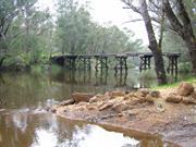
Single track over watercourse, ballasted decl 17 openings Spans 4.6m 3 log beams Piers 3 driven piles and braced trestles Abutments piled and backlined Length 78m Height 3.4m
1928, strengthening beams placed
Not in service, to be inspected
Other Built Type
| Epoch | General | Specific |
|---|---|---|
| Original Use | Transport\Communications | Rail: Other |
| Type | General | Specific |
|---|---|---|
| Other | TIMBER | Log |
| General | Specific |
|---|---|
| TRANSPORT & COMMUNICATIONS | Rail & light rail transport |
This information is provided voluntarily as a public service. The information provided is made available in good faith and is derived from sources believed to be reliable and accurate. However, the information is provided solely on the basis that readers will be responsible for making their own assessment of the matters discussed herein and are advised to verify all relevant representations, statements and information.
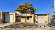
Longbottom Rd Darradup
Nannup
South West
Constructed from 1868 to 1900
| Type | Status | Date | Documents |
|---|---|---|---|
| Heritage List | Adopted | 26 Mar 2015 |
| Type | Status | Date | Documents |
|---|---|---|---|
| RHP - Does not warrant assessment | Current | 24 Sep 2004 |
| Type | Status | Date | Grading/Management | |
|---|---|---|---|---|
| Category | ||||
| Municipal Inventory | Adopted | 24 Oct 1995 | Category 1 | |
Very Good
Individual Building or Group
| Epoch | General | Specific |
|---|---|---|
| Present Use | FARMING\PASTORAL | Homestead |
| Original Use | FARMING\PASTORAL | Homestead |
| Style |
|---|
| Vernacular |
| Type | General | Specific |
|---|---|---|
| Wall | EARTH | Wattle and Daub |
| Roof | METAL | Corrugated Iron |
| General | Specific |
|---|---|
| DEMOGRAPHIC SETTLEMENT & MOBILITY | Settlements |
This information is provided voluntarily as a public service. The information provided is made available in good faith and is derived from sources believed to be reliable and accurate. However, the information is provided solely on the basis that readers will be responsible for making their own assessment of the matters discussed herein and are advised to verify all relevant representations, statements and information.
Constructed from 1868 to 1900
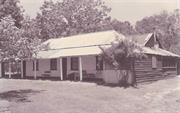
Darradup House is significant as an example of a home constructed during the early years of settlement of the Blackwood region.
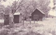
The site contains a number of timber framed structures including Darradup House an outhouse, a small cottage, shed, log structure, and several more recently constructed sheds. Darradup House is a timber framed and iron structure with a general 'T' shape floor plan with a gabled roof including prominent entrance, and surrounding skillion formed verandah. Although most external features, including weatherboard dado, and 'nosed' timber detailing to door and window frames, is consistent, the roof and plan form suggest the building has been extensively modified. The existing cottage is constructed in two sections. The front section consists of three rooms and is constructed of wattle and daub which has been cement rendered on theoutside. There are twelve pane sash windows on the front elevation. The original shingle roof has been replaced by corrugated iron. Asbestos wall linings have beenadded later. The rear section of the cottage was constructed later and is of timber framed construction with some pressed metal wall and ceiling linings.
There is some conflicting information regarding the history of Daradup House. According to information collected by the South West Heritage Taskforce in 1990, the original Darradup House constructed in 1868 by Stephen Longbottom was demolished following storm damage in 1951 and the remaining structure dates from circa 1900. However following site investigation, the style of the building and building methods and materials used indicate that at least part of the remaining structure was constructed prior to 1900. The original pastoral lease for the property dated 12/12/1894 indicates that George Longbottom held the property from Jan. 1888 to Dec. 1907. The existing cottage may have been constructed during this period.
Alterations - Various Intactness of fabric - Fair
Fair
| Ref ID No | Ref Name | Ref Source | Ref Date |
|---|---|---|---|
| SWDA information Section B | South West Heritage Taskforce | 1990 | |
| Mr Witherow (Owner) | 12/12/1894 |
| Ref Number | Description |
|---|---|
| 014 | Shire of Nannup MHI |
| Reserve | Lot/Location | Plan/Diagram | Vol/Folio |
|---|---|---|---|
| 278 | P255616 | 2081/380 |
| Owner | Category |
|---|---|
| Bianco Pty Ltd | Other Private |
This information is provided voluntarily as a public service. The information provided is made available in good faith and is derived from sources believed to be reliable and accurate. However, the information is provided solely on the basis that readers will be responsible for making their own assessment of the matters discussed herein and are advised to verify all relevant representations, statements and information.
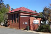
Longbottom Rd Darradup
Nannup
South West
Constructed from 1900
| Type | Status | Date | Documents |
|---|---|---|---|
| Heritage List | Adopted | 26 Mar 2015 |
| Type | Status | Date | Documents |
|---|---|---|---|
| (no listings) |
| Type | Status | Date | Grading/Management | |
|---|---|---|---|---|
| Category | ||||
| Municipal Inventory | Adopted | 24 Oct 1995 | Category 2 | |
Individual Building or Group
| Epoch | General | Specific |
|---|---|---|
| Present Use | VACANT\UNUSED | Vacant\Unused |
| Original Use | EDUCATIONAL | Combined School |
| Type | General | Specific |
|---|---|---|
| Wall | TIMBER | Weatherboard |
| Roof | METAL | Corrugated Iron |
| General | Specific |
|---|---|
| SOCIAL & CIVIC ACTIVITIES | Education & science |
This information is provided voluntarily as a public service. The information provided is made available in good faith and is derived from sources believed to be reliable and accurate. However, the information is provided solely on the basis that readers will be responsible for making their own assessment of the matters discussed herein and are advised to verify all relevant representations, statements and information.
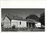
Constructed from 1900
Darradup School is of significance to the history of the development of the Nannup district. It is significant to the history of education in the south west and is a good example of a rural school from the period circa 1900.
Darradup School is constructed of timber frames and weatherboards with a corrugated iron roof.
Darradup School was the first school in the Nannup area and was established in 1900. The school was built by W. Higgins and R.G. McAtee and opened in May 1900. (Gilbert, 1973)
Alterations - Not known Intactness of fabric - Fair
Poor
| Ref Number | Description |
|---|---|
| 015 | Shire of Nannup MHI |
| Reserve | Lot/Location | Plan/Diagram | Vol/Folio |
|---|---|---|---|
| 13038 | P105832 | 1410/179 |
This information is provided voluntarily as a public service. The information provided is made available in good faith and is derived from sources believed to be reliable and accurate. However, the information is provided solely on the basis that readers will be responsible for making their own assessment of the matters discussed herein and are advised to verify all relevant representations, statements and information.
Jalbarragup Rd Jalbarragup on the Blackwood River
No 3978
Nannup
South West
Constructed from 1900
| Type | Status | Date | Documents |
|---|---|---|---|
| Heritage List | Adopted | 26 Mar 2015 | |
| State Register | Registered | 02 Jun 1998 | HCWebsite.Listing+ListingDocument, HCWebsite.Listing+ListingDocument |
| Type | Status | Date | Documents |
|---|---|---|---|
| (no listings) |
| Type | Status | Date | Grading/Management | |
|---|---|---|---|---|
| Category | ||||
| Municipal Inventory | Adopted | 24 Oct 1995 | Category 2 | |
| Classified by the National Trust | Classified | 01 Nov 1993 | ||
| Statewide Lge Timber Str Survey | Completed | 11 Dec 1998 | ||
Shire advises condition deteriorated since 1996.
| Name | Type | Year From | Year To |
|---|---|---|---|
| C S R Palmer | Architect | - | - |
Individual Building or Group
| Epoch | General | Specific |
|---|---|---|
| Present Use | VACANT\UNUSED | Vacant\Unused |
| Original Use | Transport\Communications | Road: Bridge |
| Type | General | Specific |
|---|---|---|
| Other | TIMBER | Other Timber |
| General | Specific |
|---|---|
| DEMOGRAPHIC SETTLEMENT & MOBILITY | Settlements |
| TRANSPORT & COMMUNICATIONS | Road transport |
This information is provided voluntarily as a public service. The information provided is made available in good faith and is derived from sources believed to be reliable and accurate. However, the information is provided solely on the basis that readers will be responsible for making their own assessment of the matters discussed herein and are advised to verify all relevant representations, statements and information.
Constructed from 1900
Refer to National Trust assessment.
Jalbarragup Bridge (ruin) is a now-disused turn of the century wooden river bridge. It is the only remaining turn of the century wooden bridge over the Blackwood River surviving in its original form, and one of few such bridges left in this State.
Shire advises condition deteriorated since 1996.
| Ref Number | Description |
|---|---|
| 041 | Shire of Nannup MHI |
| Owner | Category |
|---|---|
| State of WA (vested in the Shireof Nannup) | Local Gov't |
This information is provided voluntarily as a public service. The information provided is made available in good faith and is derived from sources believed to be reliable and accurate. However, the information is provided solely on the basis that readers will be responsible for making their own assessment of the matters discussed herein and are advised to verify all relevant representations, statements and information.
Black Point Rd Lake Jasper
20km from milyanup homestead, 37km from Augusta. 20km SE of Milyanup.
Nannup
South West
| Type | Status | Date | Documents |
|---|---|---|---|
| Heritage List | Adopted | 26 Mar 2015 |
| Type | Status | Date | Documents |
|---|---|---|---|
| (no listings) |
| Type | Status | Date | Grading/Management | |
|---|---|---|---|---|
| Category | ||||
| Register of the National Estate | Indicative Place | |||
| Aboriginal Heritage Sites Register | Registered | |||
| Classified by the National Trust | Classified {Lscpe} | 27 Sep 1991 | ||
| Library Id | Title | Medium | Year Of Publication |
|---|---|---|---|
| 2368 | Black Point : nomination of a geological monument for the register of the National Estate. | Book | 1991 |
Geological monument
| Epoch | General | Specific |
|---|---|---|
| Present Use | OTHER | Other |
| Original Use | OTHER | Other |
| General | Specific |
|---|---|
| SOCIAL & CIVIC ACTIVITIES | Education & science |
This information is provided voluntarily as a public service. The information provided is made available in good faith and is derived from sources believed to be reliable and accurate. However, the information is provided solely on the basis that readers will be responsible for making their own assessment of the matters discussed herein and are advised to verify all relevant representations, statements and information.
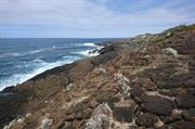
Black Point is an important outcrop of the rarely exposed Bunbury Basalt, the only post Pre-Cambrian volcanic event in the geological evolution of the Perth Basin. The basalt displays perfectly formed columnar jointing, a structure developed as a result of stresses developed when the basalt cooled and solidified in Cretaceous times. It is an important scientific research site.
The site includes two prominent cliffed headlands on the south coast of the D'Entrecasteaux National Park, about 1.1km apart. Both display spectacular exposures of the Bunbury Basalt. This formation forms part of the Perth Basin sequence and is rarely exposed at surface, though it is well known from drill intersections and geophysical studies. The formation also provides an important aquifer in the Bunbury region. The basalt shows well developed columnar cooling structures and has well developed sheet jointing. Basalt has been eroded along these joints to form a terraced outcrop. Black Point is the only site in the Perth Basin where late injection basaltic dykes occur.
| Ref Number | Description |
|---|---|
| 005 | Shire of Nannup MHI |
| Reserve | Lot/Location | Plan/Diagram | Vol/Folio |
|---|---|---|---|
| RES36996 | 311 | P52585 | LR3153-516 |
This information is provided voluntarily as a public service. The information provided is made available in good faith and is derived from sources believed to be reliable and accurate. However, the information is provided solely on the basis that readers will be responsible for making their own assessment of the matters discussed herein and are advised to verify all relevant representations, statements and information.
Sues Rd 9km from Brockman Hwy turnoff Margaret River
SLKm 9.00 Map 1, XF1 p
MRWA 3268
Sues Road Bridge over Blackwood River Sues Rd 9km from Brockman Hwy turnoff Marg
Augusta/Margaret River
South West
Constructed from 1966 to 1995
| Type | Status | Date | Documents |
|---|---|---|---|
| Heritage List | Adopted | 08 Aug 2012 |
| Type | Status | Date | Documents |
|---|---|---|---|
| RHP - To be assessed | Current | 30 Jul 2021 |
| Type | Status | Date | Grading/Management | |
|---|---|---|---|---|
| Category | ||||
| Municipal Inventory | Adopted | 01 Jul 2012 | Considerable Significance | |
| Statewide Lge Timber Str Survey | Completed | 11 Dec 1998 | ||
Historic site
| Epoch | General | Specific |
|---|---|---|
| Original Use | Transport\Communications | Road: Bridge |
| Present Use | Transport\Communications | Road: Bridge |
| Type | General | Specific |
|---|---|---|
| Other | METAL | Steel |
| Other | TIMBER | Other Timber |
This information is provided voluntarily as a public service. The information provided is made available in good faith and is derived from sources believed to be reliable and accurate. However, the information is provided solely on the basis that readers will be responsible for making their own assessment of the matters discussed herein and are advised to verify all relevant representations, statements and information.
Constructed from 1966
Sue’s Bridge is of significance: • As the tallest timber bridge in the south west (17.5m) • For the improvements it made to road access through this part of the Shire.
Length: 96.45m Spans: 16 Width: 8.64m Headroom: 17.5m Pile length (max): 21.5m Road surface: Concrete overlay
Post-War Services and Diversification (c.1945-Present) • The Closure of the Railway and Improvements to Other Transport Routes. Sues Road was named after Suzette Morrison, the wife of Forestry Officer, Ian Morrison who was in charge of the roads put in for timber assessment and logging in the 1950s.Prior to the construction of Sue’s Bridge in 1966 the only crossing at this point was a ford at what is now the nearby canoe launching area.The road was widened and sealed in 1995 to accommodate the anticipated increase in traffic for mining to the south at Beenup. The bridge was strengthened at that time by driving steel piles in behind the existing jarrah piles and adding additional cross and cantilever members.
High: The original use has been maintained. Medium: The place has had some alterations, but the original intent/character is still clearly evident
Good *Assessed from streetscape survey only
| Ref ID No | Ref Name | Ref Source | Ref Date |
|---|---|---|---|
| Interpretation panels at the Sue’s Bridge Camping and Picnic Area |
| Ref Number | Description |
|---|---|
| A11225 | LGA Site No. |
| DA-01 | MI Place No. |
| Reserve | Lot/Location | Plan/Diagram | Vol/Folio |
|---|---|---|---|
| 47670 | 5561 |
This information is provided voluntarily as a public service. The information provided is made available in good faith and is derived from sources believed to be reliable and accurate. However, the information is provided solely on the basis that readers will be responsible for making their own assessment of the matters discussed herein and are advised to verify all relevant representations, statements and information.
Nannup
Nannup
South West
Constructed from 1880
| Type | Status | Date | Documents |
|---|---|---|---|
| Heritage List | Adopted | 26 Mar 2015 |
| Type | Status | Date | Documents |
|---|---|---|---|
| (no listings) |
| Type | Status | Date | Grading/Management | |
|---|---|---|---|---|
| Category | ||||
| Municipal Inventory | Adopted | 24 Oct 1995 | Category 2 | |
Shire advises this building vacant and susceptible to vandalism & general deterioration.
Individual Building or Group
| Epoch | General | Specific |
|---|---|---|
| Present Use | VACANT\UNUSED | Vacant\Unused |
| Original Use | RESIDENTIAL | Single storey residence |
| Type | General | Specific |
|---|---|---|
| Wall | EARTH | Wattle and Daub |
| Roof | TIMBER | Shingle |
This information is provided voluntarily as a public service. The information provided is made available in good faith and is derived from sources believed to be reliable and accurate. However, the information is provided solely on the basis that readers will be responsible for making their own assessment of the matters discussed herein and are advised to verify all relevant representations, statements and information.
Constructed from 1880
Local significance, early settlement.
Cundinup House is an original wattle and daub house with shingled roof built by Heppingstone.
Derelict
| Ref Number | Description |
|---|---|
| 013 | Shire of Nannup MHI |
| Reserve | Lot/Location | Plan/Diagram | Vol/Folio |
|---|---|---|---|
| 8000 | P201567 | 1349/561 |
This information is provided voluntarily as a public service. The information provided is made available in good faith and is derived from sources believed to be reliable and accurate. However, the information is provided solely on the basis that readers will be responsible for making their own assessment of the matters discussed herein and are advised to verify all relevant representations, statements and information.
Nannup
Nannup
South West
Constructed from 1962
| Type | Status | Date | Documents |
|---|---|---|---|
| (no listings) |
| Type | Status | Date | Documents |
|---|---|---|---|
| (no listings) |
| Type | Status | Date | Grading/Management | |
|---|---|---|---|---|
| Category | ||||
| (no listings) | ||||
Historic site
| Epoch | General | Specific |
|---|---|---|
| Original Use | FORESTRY | Other |
This information is provided voluntarily as a public service. The information provided is made available in good faith and is derived from sources believed to be reliable and accurate. However, the information is provided solely on the basis that readers will be responsible for making their own assessment of the matters discussed herein and are advised to verify all relevant representations, statements and information.
| Ref Number | Description |
|---|---|
| 049 | Shire of Nannup MHI |
| Reserve | Lot/Location | Plan/Diagram | Vol/Folio |
|---|---|---|---|
| 701 | P71448 | 2776/287 |
This information is provided voluntarily as a public service. The information provided is made available in good faith and is derived from sources believed to be reliable and accurate. However, the information is provided solely on the basis that readers will be responsible for making their own assessment of the matters discussed herein and are advised to verify all relevant representations, statements and information.
Nannup
Nannup
South West
Constructed from 1900 to 1920
| Type | Status | Date | Documents |
|---|---|---|---|
| Heritage Area | Adopted | 25 Jan 2018 | |
| Heritage List | Adopted | 26 Mar 2015 |
| Type | Status | Date | Documents |
|---|---|---|---|
| RHP - To be assessed | Current | 10 Dec 2004 |
| Type | Status | Date | Grading/Management | |
|---|---|---|---|---|
| Category | ||||
| (no listings) | ||||
Precinct or Streetscape
| Epoch | General | Specific |
|---|---|---|
| Original Use | RESIDENTIAL | Other |
| Original Use | COMMERCIAL | Other |
| Type | General | Specific |
|---|---|---|
| Wall | TIMBER | Weatherboard |
| General | Specific |
|---|---|
| DEMOGRAPHIC SETTLEMENT & MOBILITY | Settlements |
| SOCIAL & CIVIC ACTIVITIES | Community services & utilities |
| OCCUPATIONS | Timber industry |
This information is provided voluntarily as a public service. The information provided is made available in good faith and is derived from sources believed to be reliable and accurate. However, the information is provided solely on the basis that readers will be responsible for making their own assessment of the matters discussed herein and are advised to verify all relevant representations, statements and information.
| Ref Number | Description |
|---|---|
| 062 | Shire of Nannup MHI |
| Owner | Category |
|---|---|
| Shire of Nannup | Local Gov't |
This information is provided voluntarily as a public service. The information provided is made available in good faith and is derived from sources believed to be reliable and accurate. However, the information is provided solely on the basis that readers will be responsible for making their own assessment of the matters discussed herein and are advised to verify all relevant representations, statements and information.
Nannup
Nannup
South West
Constructed from 1864 to 1924
| Type | Status | Date | Documents |
|---|---|---|---|
| Heritage List | Adopted | 26 Mar 2015 |
| Type | Status | Date | Documents |
|---|---|---|---|
| (no listings) |
| Type | Status | Date | Grading/Management | |
|---|---|---|---|---|
| Category | ||||
| Municipal Inventory | Adopted | 24 Oct 1995 | Category 6 | |
Individual Building or Group
| Epoch | General | Specific |
|---|---|---|
| Present Use | RESIDENTIAL | Single storey residence |
| Original Use | RESIDENTIAL | Single storey residence |
| Type | General | Specific |
|---|---|---|
| Wall | TIMBER | Other Timber |
| Wall | EARTH | Adobe {Mud Brick} |
This information is provided voluntarily as a public service. The information provided is made available in good faith and is derived from sources believed to be reliable and accurate. However, the information is provided solely on the basis that readers will be responsible for making their own assessment of the matters discussed herein and are advised to verify all relevant representations, statements and information.
Constructed from 1924, Constructed from 1864
Local significance, settlement.
House built of hand hewn timber and mud bricks fired on the site. Extended 1924
| Ref Number | Description |
|---|---|
| 070 | Shire of Nannup MHI |
| Reserve | Lot/Location | Plan/Diagram | Vol/Folio |
|---|---|---|---|
| 147 | P105963 | 1043/267 |
This information is provided voluntarily as a public service. The information provided is made available in good faith and is derived from sources believed to be reliable and accurate. However, the information is provided solely on the basis that readers will be responsible for making their own assessment of the matters discussed herein and are advised to verify all relevant representations, statements and information.
Nannup
Nannup
South West
Constructed from 1900
| Type | Status | Date | Documents |
|---|---|---|---|
| (no listings) |
| Type | Status | Date | Documents |
|---|---|---|---|
| (no listings) |
| Type | Status | Date | Grading/Management | |
|---|---|---|---|---|
| Category | ||||
| Municipal Inventory | Adopted | 24 Oct 1995 | Category 5 | |
Historic Site
| Epoch | General | Specific |
|---|---|---|
| Present Use | FARMING\PASTORAL | Other |
| Original Use | FARMING\PASTORAL | Other |
This information is provided voluntarily as a public service. The information provided is made available in good faith and is derived from sources believed to be reliable and accurate. However, the information is provided solely on the basis that readers will be responsible for making their own assessment of the matters discussed herein and are advised to verify all relevant representations, statements and information.
Constructed from 1900
Significant to the development of the pastoral industry in the State and the settlement of the Southwest.
| Ref Number | Description |
|---|---|
| 076 | Shire of Nannup MHI |
| Owner | Category |
|---|---|
| CALM | State Gov't |
This information is provided voluntarily as a public service. The information provided is made available in good faith and is derived from sources believed to be reliable and accurate. However, the information is provided solely on the basis that readers will be responsible for making their own assessment of the matters discussed herein and are advised to verify all relevant representations, statements and information.
10km south east of Nannup Nannup
Nannup
South West
Constructed from 1940
| Type | Status | Date | Documents |
|---|---|---|---|
| (no listings) |
| Type | Status | Date | Documents |
|---|---|---|---|
| (no listings) |
| Type | Status | Date | Grading/Management | |
|---|---|---|---|---|
| Category | ||||
| Municipal Inventory | Adopted | 24 Oct 1995 | Management Category D | |
Historic site
| Epoch | General | Specific |
|---|---|---|
| Original Use | FORESTRY | Other |
This information is provided voluntarily as a public service. The information provided is made available in good faith and is derived from sources believed to be reliable and accurate. However, the information is provided solely on the basis that readers will be responsible for making their own assessment of the matters discussed herein and are advised to verify all relevant representations, statements and information.

Constructed in 1940 off Tower Road in East Nannup.
This information is provided voluntarily as a public service. The information provided is made available in good faith and is derived from sources believed to be reliable and accurate. However, the information is provided solely on the basis that readers will be responsible for making their own assessment of the matters discussed herein and are advised to verify all relevant representations, statements and information.
26km south of Nannup Nannup
Biddellia Tower
Nannup
South West
Constructed from 1948
| Type | Status | Date | Documents |
|---|---|---|---|
| (no listings) |
| Type | Status | Date | Documents |
|---|---|---|---|
| (no listings) |
| Type | Status | Date | Grading/Management | |
|---|---|---|---|---|
| Category | ||||
| Municipal Inventory | Adopted | 24 Oct 1995 | Management Category D | |
Historic site
| Epoch | General | Specific |
|---|---|---|
| Original Use | FORESTRY | Other |
This information is provided voluntarily as a public service. The information provided is made available in good faith and is derived from sources believed to be reliable and accurate. However, the information is provided solely on the basis that readers will be responsible for making their own assessment of the matters discussed herein and are advised to verify all relevant representations, statements and information.
Constructed in 1948 on Dickson Road. Not currently in use.
This information is provided voluntarily as a public service. The information provided is made available in good faith and is derived from sources believed to be reliable and accurate. However, the information is provided solely on the basis that readers will be responsible for making their own assessment of the matters discussed herein and are advised to verify all relevant representations, statements and information.
Adam St Nannup
Nannup
South West
Constructed from 1966
| Type | Status | Date | Documents |
|---|---|---|---|
| (no listings) |
| Type | Status | Date | Documents |
|---|---|---|---|
| (no listings) |
| Type | Status | Date | Grading/Management | |
|---|---|---|---|---|
| Category | ||||
| Fire & Rescue Service Heritage Inventory | Adopted | 30 Aug 1997 | ||
| Municipal Inventory | Adopted | 01 Feb 1996 | Management Category D | |
Individual Building or Group
| Epoch | General | Specific |
|---|---|---|
| Present Use | GOVERNMENTAL | Fire Station |
| Original Use | GOVERNMENTAL | Fire Station |
| Type | General | Specific |
|---|---|---|
| Wall | BRICK | Common Brick |
| Roof | METAL | Corrugated Iron |
| General | Specific |
|---|---|
| SOCIAL & CIVIC ACTIVITIES | Community services & utilities |
This information is provided voluntarily as a public service. The information provided is made available in good faith and is derived from sources believed to be reliable and accurate. However, the information is provided solely on the basis that readers will be responsible for making their own assessment of the matters discussed herein and are advised to verify all relevant representations, statements and information.
Constructed from 1966
The Nannup Fire Station is constructed of common brick and weatherboard with a corrugated iron roof.
Nannup Fire Station was constructed in 1966.
Good condition
This information is provided voluntarily as a public service. The information provided is made available in good faith and is derived from sources believed to be reliable and accurate. However, the information is provided solely on the basis that readers will be responsible for making their own assessment of the matters discussed herein and are advised to verify all relevant representations, statements and information.
Lot 242 Adam St Nannup
Shire Office
Nannup
South West
Constructed from 1905 to 1966
| Type | Status | Date | Documents |
|---|---|---|---|
| Heritage List | Adopted | 26 Mar 2015 |
| Type | Status | Date | Documents |
|---|---|---|---|
| (no listings) |
| Type | Status | Date | Grading/Management | |
|---|---|---|---|---|
| Category | ||||
| Municipal Inventory | Adopted | 24 Oct 1995 | Category 2 | |
Individual Building or Group
| Epoch | General | Specific |
|---|---|---|
| Original Use | EDUCATIONAL | Primary School |
| Present Use | GOVERNMENTAL | Office or Administration Bldg |
| Type | General | Specific |
|---|---|---|
| Roof | METAL | Corrugated Iron |
| Wall | TIMBER | Weatherboard |
| General | Specific |
|---|---|
| SOCIAL & CIVIC ACTIVITIES | Education & science |
This information is provided voluntarily as a public service. The information provided is made available in good faith and is derived from sources believed to be reliable and accurate. However, the information is provided solely on the basis that readers will be responsible for making their own assessment of the matters discussed herein and are advised to verify all relevant representations, statements and information.
Constructed from 1966, Constructed from 1905
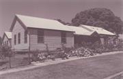
The Nannup shire offices are significant because they incorporate the original Nannup school dating from 1905 and the Ellis Creek School relocated to Nannup circa 1925.
The building has been refurbished to meet the requirement of the Shire. The second classroom which was relocated from Barabup has been demolished, however the classroom from Ellis Creek still exists and is used as the library. The original school buildings were constructed of weatherboard with corrugated iron roof sheeting typical of schoolroom constructed throughout the region's timber towns in the early 1900s. Their relocation and reuse is also typical pattern of use typical for timber framed school buildings throughout the region.
The Nannup Shire office was previously the Nannup Primary School which consisted of one classroom when it opened in 1905. The first Nannup school opened in September 1903 and was conducted in the Agricultural Hall until the school was built. Additional classrooms were added circa 1925 when the schools from Barrabup and Ellis Creek were relocated to Nannup. In 1930 a new brick school building was planned and the first classroom constructed, (present pre-primary centre) However the school was never completed. In 1966 the Shire took over the school building.
Alterations Numerous Intactness of fabric Fair
Good
| Ref ID No | Ref Name | Ref Source | Ref Date |
|---|---|---|---|
| SWDA information Section A | South West Heritage Taskforce | 1990 | |
| C Gilbert;"History of Nannup" | unpublished | 1973 |
| Ref Number | Description |
|---|---|
| 060 | Shire of Nannup MHI |
| Reserve | Lot/Location | Plan/Diagram | Vol/Folio |
|---|---|---|---|
| RES29142 | 242 | P186227 | LR3050-19 |
| Owner | Category |
|---|---|
| Shire of Nannup | Local Gov't |
This information is provided voluntarily as a public service. The information provided is made available in good faith and is derived from sources believed to be reliable and accurate. However, the information is provided solely on the basis that readers will be responsible for making their own assessment of the matters discussed herein and are advised to verify all relevant representations, statements and information.
Cnr Adam St & Grange Rd Nannup
School
Nannup
South West
Constructed from 1930
| Type | Status | Date | Documents |
|---|---|---|---|
| Heritage List | Adopted | 26 Mar 2015 |
| Type | Status | Date | Documents |
|---|---|---|---|
| (no listings) |
| Type | Status | Date | Grading/Management | |
|---|---|---|---|---|
| Category | ||||
| Municipal Inventory | Adopted | 24 Oct 1995 | Category 2 | |
Individual Building or Group
| Epoch | General | Specific |
|---|---|---|
| Present Use | EDUCATIONAL | Pre-primary Centre |
| Original Use | EDUCATIONAL | Combined School |
| Type | General | Specific |
|---|---|---|
| Roof | METAL | Corrugated Iron |
| Wall | BRICK | Common Brick |
| General | Specific |
|---|---|
| SOCIAL & CIVIC ACTIVITIES | Education & science |
This information is provided voluntarily as a public service. The information provided is made available in good faith and is derived from sources believed to be reliable and accurate. However, the information is provided solely on the basis that readers will be responsible for making their own assessment of the matters discussed herein and are advised to verify all relevant representations, statements and information.
Constructed from 1930
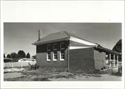
The Pre-Primary Centre, originally part of the Nannup Primary School, is significant to the historical development of Nannup. It is typical of rural school of the era.
The Nannup Pre-Primary Centre was originally constructed as the first stage of a new brick school building in 1930. Six classrooms were planned, but only one was constructed. The building has been adapted to suit the need of the pre-primary centre.
Alterations Various alterations, but the original external fabric remains intact Intactness of fabric Fair
Good
| Ref ID No | Ref Name | Ref Source | Ref Date |
|---|---|---|---|
| SWDA information Section A | South West Heritage Taskforce | 1990 |
| Ref Number | Description |
|---|---|
| 058 | Shire of Nannup MHI |
| Reserve | Lot/Location | Plan/Diagram | Vol/Folio |
|---|---|---|---|
| RES29142 | 242 | P186227 | LR3050-19 |
This information is provided voluntarily as a public service. The information provided is made available in good faith and is derived from sources believed to be reliable and accurate. However, the information is provided solely on the basis that readers will be responsible for making their own assessment of the matters discussed herein and are advised to verify all relevant representations, statements and information.
Balingup Rd Nannup
Nannup
South West
Constructed from 1850
| Type | Status | Date | Documents |
|---|---|---|---|
| Heritage List | Adopted | 26 Mar 2015 |
| Type | Status | Date | Documents |
|---|---|---|---|
| (no listings) |
| Type | Status | Date | Grading/Management | |
|---|---|---|---|---|
| Category | ||||
| Municipal Inventory | Adopted | 24 Oct 1995 | Category 6 | |
Individual Building or Group
| Epoch | General | Specific |
|---|---|---|
| Original Use | RESIDENTIAL | Single storey residence |
| Present Use | RESIDENTIAL | Single storey residence |
| Type | General | Specific |
|---|---|---|
| Wall | STONE | Local Stone |
This information is provided voluntarily as a public service. The information provided is made available in good faith and is derived from sources believed to be reliable and accurate. However, the information is provided solely on the basis that readers will be responsible for making their own assessment of the matters discussed herein and are advised to verify all relevant representations, statements and information.
Constructed from 1850
Dudinalup has Local significance as an example of early settlement.
The original Dudinalup House consisted of two stone rooms which have now been incorporated into a larger house.
Dudinalup was built in 1850 thought to be by JG Reynolds.
Good condition
| Ref Number | Description |
|---|---|
| 019 | Shire of Nannup MHI |
| Reserve | Lot/Location | Plan/Diagram | Vol/Folio |
|---|---|---|---|
| 6 | P254989 | 1108/881 |
This information is provided voluntarily as a public service. The information provided is made available in good faith and is derived from sources believed to be reliable and accurate. However, the information is provided solely on the basis that readers will be responsible for making their own assessment of the matters discussed herein and are advised to verify all relevant representations, statements and information.
Balingup Rd Nannup
Nannup
South West
Constructed from 1870
| Type | Status | Date | Documents |
|---|---|---|---|
| Heritage List | Adopted | 26 Mar 2015 |
| Type | Status | Date | Documents |
|---|---|---|---|
| RHP - To be assessed | Current | 24 Sep 2004 |
| Type | Status | Date | Grading/Management | |
|---|---|---|---|---|
| Category | ||||
| Municipal Inventory | Adopted | 24 Oct 1995 | Category 1 | |
The place is a good representative of the type of farm homesteads that were constructed in the second half of the 19th century in Western Australia.
The place has aesthetic value for its picturesque setting and simple architectural form.
The place was amongst the first group of farm homesteads to be constructed in the Nannup area and retains a high degree of authentic fabric.
The place is associated with William Ellis, one of the original European settlers in the Nannup area.
Tathra Cottage is one of a number of buildings disbursed over a large rural property. The immediate environs around the cottage have been landscaped and developed for tourist purposes, including a dam and lawned picnic area with shelters and a café and fruit-wine tasting area. Tathra Cottage is located on the eastern side of Balingup Road, 14kms from Nannup, on a site bound by Balingup Road, and adjoining rural properties to the north, south and east. A red gravel drive provides access off Balingup Road, leading to a small circular car park for the Cottage and Café area, before continuing up a gradual hill to short stay accommodation. The Cottage is situated in a leafy landscaped picnic area adjacent a dam, with a timber pole and shade cloth shelter to the northwest, and a timber framed and iron café and fruit-wine tasting area to the southwest. Both of these structures are contemporary and of little significance. The Cottage consists of a simple, whitewashed timber pole and slab structure with gabled iron roof over the main room, skillion formed verandah to the north, and skillion roofed enclosure to the south. Features include a random laid stone chimney and flue to the east façade, along with a variety of timber framed windows to the north, east and south. A panel of louvered windows has been added to the southwest.
‘Prior to 1850 all land was disposed of by sale. However, in 1850 legislation was passed which made provision for pastoral leases on land more than two mile from the coast, occupied townships or principal rivers. Leases cost 10s. per 1 000 acres for an eight-year period with the prospect of renewal at the end of that period. As a direct result settlers began moving into the timber country of the southwest. Grazing leases adjacent to the south coast were also taken up at this period.’ ‘In 1852 Assistant Surveyor Augustus Charles Gregory explored extensively in the area of the Blackwood and Donnelly Rivers. Land surveys were undertaken in 1858 by Assistant Surveyor Robert Austin whose report refers to several settlers in the area and to localities later known as Tanjannerup, Dudinalup and Cundunup.’ ‘Tathra Cottage was established by one of the first settlers in the Nannup region, William Ellis.
Integrity- Moderate Authenticity- High
Good
Individual Building or Group
| Epoch | General | Specific |
|---|---|---|
| Present Use | EDUCATIONAL | Museum |
| Original Use | FARMING\PASTORAL | Homestead |
| Style |
|---|
| Victorian Georgian |
| Vernacular |
| Type | General | Specific |
|---|---|---|
| Wall | TIMBER | Slab |
| Other | STONE | Local Stone |
| Roof | METAL | Corrugated Iron |
| General | Specific |
|---|---|
| DEMOGRAPHIC SETTLEMENT & MOBILITY | Settlements |
| PEOPLE | Early settlers |
This information is provided voluntarily as a public service. The information provided is made available in good faith and is derived from sources believed to be reliable and accurate. However, the information is provided solely on the basis that readers will be responsible for making their own assessment of the matters discussed herein and are advised to verify all relevant representations, statements and information.
Constructed from 1870
Tathra Cottage is significant as representative of the housing constructed by the earliest settlers in the Blackwood Valley region in the early years of settlement in the area. The significance of the cottage has been conserved by the restoration project undertaken by the present owners.
The Cottage consists of a simple, white washed timber pole and slab structure with gabled iron roof over the main room, skillion formed verandah to the north, and skillion roofed enclosure to the south. Features include a random laid stone chimney and flue to the east façade, along with a variety of timber framed windows to the north, east and south. A panel of louvered windows has been added to the southwest. Vernacular interpretation of Victorian Georgian style. Tathra Cottage is an example of an original slab construction dwelling dating from the early settlement of the Blackwood Valley region.
The building has been conserved and restored by the present owner and is open to the public as a folk museum with an interpretive display depicting the life of the early settlers. Tathra Cottage is believed to have been built by William Ellis who took up land in the Ellis Creek area circa 1870 and is constructed of jarrah slabs and bush poles cut from the forest. The roof is corrugated iron.
Alterations Not known Intactness of fabric Good
Good
| Ref ID No | Ref Name | Ref Source | Ref Date |
|---|---|---|---|
| C Gilber;"History of Nannup" | Unpublished | 1973 |
| Ref Number | Description |
|---|---|
| 081 | Shire of Nannup MHI |
| Reserve | Lot/Location | Plan/Diagram | Vol/Folio |
|---|---|---|---|
| 780 | P12565 | 1514/995 |
| Owner | Category |
|---|---|
| B & B Collett | Other Private |
This information is provided voluntarily as a public service. The information provided is made available in good faith and is derived from sources believed to be reliable and accurate. However, the information is provided solely on the basis that readers will be responsible for making their own assessment of the matters discussed herein and are advised to verify all relevant representations, statements and information.
Nr Balingup Rd Nannup
Agg Road Bridge
Nannup
South West
Constructed from 1921
| Type | Status | Date | Documents |
|---|---|---|---|
| Heritage List | Adopted | 26 Mar 2015 |
| Type | Status | Date | Documents |
|---|---|---|---|
| RHP - Does not warrant assessment | Current | 29 Feb 2008 |
| Type | Status | Date | Grading/Management | |
|---|---|---|---|---|
| Category | ||||
| Municipal Inventory | Adopted | 24 Oct 1995 | Category 2 | |
Historic Site
| Epoch | General | Specific |
|---|---|---|
| Present Use | Transport\Communications | Road: Bridge |
| Original Use | Transport\Communications | Road: Bridge |
This information is provided voluntarily as a public service. The information provided is made available in good faith and is derived from sources believed to be reliable and accurate. However, the information is provided solely on the basis that readers will be responsible for making their own assessment of the matters discussed herein and are advised to verify all relevant representations, statements and information.
Constructed from 1921
Significant to the settlement of the area.
Built to provide year round access to properties on northern side of Blackwood River. Replaced an earlier seasonal crossing two miles upstream.
| Ref Number | Description |
|---|---|
| 072 | Shire of Nannup MHI |
| Owner | Category |
|---|---|
| Department for Planning and Infrastructure | State Gov't |
| Main Roads Department | State Gov't |
| Shire of Nannup | Local Gov't |
This information is provided voluntarily as a public service. The information provided is made available in good faith and is derived from sources believed to be reliable and accurate. However, the information is provided solely on the basis that readers will be responsible for making their own assessment of the matters discussed herein and are advised to verify all relevant representations, statements and information.
Balingup Rd to Warren Rd Nannup
Dunnett St follows the route. bypass through Nannup town.
Nannup
South West
Constructed from 1900
| Type | Status | Date | Documents |
|---|---|---|---|
| (no listings) |
| Type | Status | Date | Documents |
|---|---|---|---|
| (no listings) |
| Type | Status | Date | Grading/Management | |
|---|---|---|---|---|
| Category | ||||
| Municipal Inventory | Adopted | 24 Oct 1995 | Category 5 | |
Historic Site
| Epoch | General | Specific |
|---|---|---|
| Original Use | FARMING\PASTORAL | Other |
| Present Use | FARMING\PASTORAL | Other |
This information is provided voluntarily as a public service. The information provided is made available in good faith and is derived from sources believed to be reliable and accurate. However, the information is provided solely on the basis that readers will be responsible for making their own assessment of the matters discussed herein and are advised to verify all relevant representations, statements and information.
Constructed from 1900
Significant to the development of the pastoral industry in the State and the settlement of the Southwest.
Historic route without built features.
Bypass through Nannup town from Balingup Rd to Warren Rd. Julius Brockman gave a portion of the land from Balingup Rd to Kearney St (moved his fence) so that drovers could use the route. Dunnett Rd follows the route.
| Ref Number | Description |
|---|---|
| 006 | Shire of Nannup MHI |
This information is provided voluntarily as a public service. The information provided is made available in good faith and is derived from sources believed to be reliable and accurate. However, the information is provided solely on the basis that readers will be responsible for making their own assessment of the matters discussed herein and are advised to verify all relevant representations, statements and information.