Local Government
Northampton
Region
Midwest
Off Baddera Rd Alma
Baddera Mine, Old Baddera
North Baddera Mine, New Baddera, Extended
Northampton
Midwest
Constructed from 1906 to 1951
| Type | Status | Date | Documents |
|---|---|---|---|
| Heritage List | Removed from MI | 15 May 2020 | |
| State Register | Registered | 27 Dec 2002 | HCWebsite.Listing+ListingDocument, HCWebsite.Listing+ListingDocument |
| Type | Status | Date | Documents |
|---|---|---|---|
| (no listings) |
| Type | Status | Date | Grading/Management | |
|---|---|---|---|---|
| Category | ||||
| Mining Heritage Study | Completed | 30 Jun 1999 | ||
| Municipal Inventory | Adopted | 19 Apr 1996 | Category 1A | |
| Library Id | Title | Medium | Year Of Publication |
|---|---|---|---|
| 4556 | A heritage assessment of the Baddera Mines : Northampton Mineral Field. | Heritage Study {Other} | 2000 |
Historic Site
| Epoch | General | Specific |
|---|---|---|
| Present Use | VACANT\UNUSED | Vacant\Unused |
| Original Use | MINING | Mining Battery |
| Style |
|---|
| Other Style |
| General | Specific |
|---|---|
| DEMOGRAPHIC SETTLEMENT & MOBILITY | Resource exploitation & depletion |
| OCCUPATIONS | Mining {incl. mineral processing} |
This information is provided voluntarily as a public service. The information provided is made available in good faith and is derived from sources believed to be reliable and accurate. However, the information is provided solely on the basis that readers will be responsible for making their own assessment of the matters discussed herein and are advised to verify all relevant representations, statements and information.
Constructed from 1873
1993 The Baddera Mine site has very high historic, social and scientific significance for the community and the potential for an interpretive understanding of mining. The Baddera Mine site requires a high level of protection under the Municipal Inventory. Accordingly, it also warrants archaeological work as the remnants on the site are more complete than at other mine sites and as such will lend itself as a place of'interpretation'for the mining activities in the region. Because the site is visible and more comprehensible than most other old mine sites there should at least be interpretive signage on the site to convey an understanding of the place whether or not a full cultural tourism project eventuates. (See also Site No. 35 for suggestions of cultural tourism potential of the Wheal Fortune Mine site, and sites 88 &117 for the tourist potential of the Wheal Ellen Mine and State Battery.) 2004 Baddera Mines, an industrial archaeology site containing the physical remnants of Baddera and Baddera North mine sites, has cultural heritage significance for the following reasons: Baddera Mine was Western Australia's largest lead producer in the early decades of the twentieth century and was closely linked with early attempts to establish a works to smelt Kalgoorlie gold ores; due to the state of preservation of their evidence, Baddera Mines are important reference sites for the understanding of other sites on the Northampton Mineral Field; the place illustrates the development of mining and processing technology over the first half of the twentieth century; the place contains rare evidence of the application of steam power to mining and processing; the place contains rare, and probably unique in Australia, evidence of the application of a Frenier pump; North Baddera Mine contains a rare, and possibly the State's only, surviving in situ example of a oncecommon Huntington mill; the place has links with important figures in the early development of the state's mining industry, including George Klug, W.G.fSutherland, and E. Protheroe Jones; and North Baddera Mine has social value for the community as the site, within living memory, of a tragic mining accident, thus demonstrating the risks involved in the mining industry throughout its history.
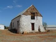
1993 Roof: Integrity: Low Modifications: Dismantled mine N/A The Baddera Mine site is located on the side of a gently rising hill and as such it is possible to get a slightly elevated and general overview to grasp the concept of the workings and function of the site. The site itself comprises extensive mine workings, tailing dumps, footings and concrete plinths, crushing equipment etc. left from one of the more recently operating (1950's) large mines in the district. There are also the ruins of stone and brick enclosures to buildings, and the base of a brick lined stone smelter chimney together with various scattered shafts and open pits. The mine has operated during various periods in the history of mining in the district and, being one of the more recently operating on some scale, has more interpretive material available to provide an understanding of the contribution mining made to the community. Baddera can also provide an example of more recent mining activity in comparison with the historic remnants of mining activity at the Wheal Fortune (Site No.35), Wheal Ellen (Site No. 117) mines and the State Battery (Site No. 88). About six miles north of Northampton, the Baddera Mine was discovered in 1873 and worked for several years to produce galena. During this time, Crowther and Mitchell obtained 176 tons of lead ore in 1878, 68 tons in 1879 and 374 tons in 1880. After being sampled by S. Cullingworth and being re-opened by the Fremantle Trading Company in 1907, its shaft was 347 ft deep in 1913, and No. two level was 800 ft long and No. three level was being driven. It was producing about 2200 tons of ore per month containing about 215 tons of lead. In 1915, stoping was being done over lengths of 630 ft at No. one level, 800 ft at No. 2 level, and 400 ft at No. three level. The Fremantle Trading company closed this mine in 1921, after working the main lode to a depth of 450 ft and a length of 1100 ft. By this date the mine had yielded 129.3 K tons of ore containing 13,890 tons of lead worth over 317 000 pounds. The mine was re-worked in the 1950s, and was closed in 1953 after two men were killed by a fall of rock. 2004 Baddera mine is 8km north of the township of Northampton and is reached by travelling 1.4 km east along Baddera Road and entering the wire gate at the south west corner of Location 1472. North Baddera Mine is some 500m north east of the Baddera, from which its tailings dump can be clearly seen. Vehicle access (4WD) between the mines is possible via a bushtrack and cleared exploration grid lines, but the North Baddera main shaft and treatment area are concealed by thick scrub and not easy to find. There is better vehicle access from a station track heading east from the main highway some 500m north of the Ladyland turnoff, but this is through private property. Baddera Mine With some notable exceptions, the evidence is that of the foundations of mining and treatment plant, the equipment having been removed for use at other sites after the mine's closure in the 1920s. The oldest structures at Baddera probably date from around 1906. Only the stone-work building-in of the Cornish boiler (no longer on site), and the foundations of its stack, remain from this period (NR037-1). Two or possibly three other periods of subsequent work are evident in the main shaft, treatment plant and boiler house areas. One includes the stonework building-in of the two existing Cornish boilers, the ducting of their flues to the older stack (NR037-4 to NR037-12), and the stonework plinths of crushers, tanks and Wilfley tables. These probably date from 1910, the beginning of the Baddera mine's most productive period which lasted to 1920. Concrete work in the last period mainly consists of plinths for Wilfley tables, treatment tanks and their motors. The general layout of the mine is with the steam generation plant at its centre, the main shaft, to the south and the treatment plant to the north. The flow direction of the treatment plant was from west to east, towards the tailings dump. The foundations of a fairly substantial house, possibly that of the mine manager, lie some distance away to the east. A roller crusher east of the main site (NR037-20 to NR037-21) was evidently not related to the original mine. Frenier pump spirals and drive In the north-west corner of the site are scattered 14 disk-shaped metal casings, some alongside a substantial machine drive. The casings, 4 ft (1.2m) diameter and 10 inches (250ml) deep, are formed of 5 ft (1,5ml) steel plate and contain within them a spiral of 6 turns at 55ml spacing (NR037-16 to NR037-18). The remnants match the description of a Frenier Pump. Roller crusher The crusher has been crudely mounted on a rock foundation (NR037-20 to NR037-21), now mainly collapsed. It is distant from the main treatment area and is almost certainly a remnant of a small scale, much later mining operation, possibly from the 1951-53 period. The 'house' The base of a stone-walled building survives in the eastern part of the site. Remains of two rooms are visible, one 2.6m x 4.9m wide, the other about 7m x 4.9m. This may have been a manager's residence, or it could have served a mine function such as storage, smithy or explosives magazine. Ventilation shaft This is a single compartment shaft, 1.8m x 0.8m, sawn timber lined with a bush timber collar. It has two 200ml timber stumps, 1.5m centres, near its south-western corner. Southern shaft Just outside the southern boundary of Location 1472 there is a deep pit that is being used as a rubbish tip. This corresponds to the southernmost shaft on the mine, noted by Feldtmann. North Baddera Mine Due to the isolated location of the mine, the remains of the North Baddera treatment plant have been well preserved apart from the ingress of the surrounding bush (NR037-29). While the North Baddera mine was operational several houses were built within Location 1472 to the west of the mine, and about 100m from it. The sites are now in very thick bush but traces of at least one can be identified. The treatment area is concrete floored throughout and was at least in part covered. From the mine shaft (NR037-23) the ore was raised to a bin. From the documentary evidence it is known that the ore was passed from the bin to a primary crusher, which was probably mounted on the H-shaped foundation near the Huntington mill (NR037-24); it was then fed via a trommel to the mill for fine grinding and thence over the Wilfley tables (NR037-27 to NR037-28) for mineral concentration. The Huntington mill (NR037-23 to NR037-25) is a pendulum (or centrifugal) mill in which suspended rollers crush the ore against a ring die. The remnant on site consists of the roller pendulum hanger ('spider' plate), central shaft, part of the ring die housing, timber bed and the drive shaft. Sparse remnants of habitation were noted some 70m east of the main shaft, but there was insufficient time to investigate these in detail.
Baddera Mines is situated on Location 1472, 8.8km north of Northampton and 1.6km east of the North West Coastal Highway. Two mines have been worked on the site, Baddera and Baddera North. These have also been known as Old Baddera and New Baddera, respectively. The southern extension of the Baddera ore body has been worked as the Baddera South mine. Baddera Mine was established in 1873 and worked for about ten years to a maximum depth of 30 metres. No production figures are available for this period but lead concentrates averaging 72% lead were produced to the value of £34,000. The mine was reopened and worked from 1910to 1921, during which time 14,110 tonnes of lead were produced from 131,340 tonnes of ore with an average grade of about 11% lead. This was the largest production of any lead mine in Western Australia. Baddera North was worked from 1948 to 1953 and yielded 730 tonnes of lead from 15,610 tonnes of ore with an average grade of approximately 5% lead. Key stages in the lives of the mines • First Phase of Mining 1873 c. 1900 • Mining for Smelter Flux 1900 - 1906 •The Change from Smelting to Lead Mining 1906-1910 •The First World War and the Lead Mining Boom • North Baddera Mine 1947-1953 •The January 1953 Mine Disaster •Two small 'shows' operated for short periods at Baddera,1951-53. • Ore from the Gurkha mine was processed at the North Baddera treatment plant, 1953-56. • G.H. Mitchell trucked tailings and hand-picked concentrates from the South Baddera dump for reprocessing at the Northampton State Battery, 1964-66 • During the base metals pegging boom the Baddera area pegged, 1970. for 'speculative purposes'. • Baddera and neighbouring areas drilled by Hillcrest Resources., 1997-98 Chronology Entries 1872 The Baddera Mine opened.
Integrity: Low Modifications: Dismantled mine Orig'l Fabric: Very little remains intact
Good
| Ref ID No | Ref Name | Ref Source | Ref Date |
|---|---|---|---|
| Wilson, R.C; "The Northampton Mineral Field". | Department of Mines, WA, | 1926 | |
| "Article". p.5 | Mining and Pastoral Register and Builders' Gazette, | 1 December 1921, | |
| "Lead Mines to Close". p. 15 | Mining and Pastoral Register and Builders' Gazette, | 1 February 1922, | |
| "Northampton Lead Mines, WA,". p. 447 | Chemical Engineering and Mining Review, | 5 September 1920, | |
| "Magazine Article". pp. 27-30 | Mining & Chemical Engineering Review, | 15 December 1965, | |
| Mining Manual & Mining Year Book, | 1914, to 1920. | ||
| Cumming, D.A; "Preliminary Notes on the Northampton Mineral Field". p.3 | 1993 | ||
| Montgomery, A. "Report on the Northampton Mineral Field" | Department of Mines, WA, | 1908 | |
| "Magazine Article". | Chemical Engineering and Mining Review, | 5 December 1921. | |
| Wray, C.H. Bewick Moreing; "Mining prospect inspection report". | Department of Minerals and Energy, WA. | 26 Feb.1907, | |
| MacGill, G. and Hartley, R.J; "A heritage assessment of the Baddera Mines, Northampton Mineral Field". | Heritage Council of Western Australia, | 2000 | |
| "Report". | Western Australian Dept of Mines Annual Reports | 1915, 1922. | |
| "Magazine Article". | Mining, Pastoral & Industrial Magazine, | 4 March 1919. | |
| Crabb, J; "Notes on the Mining Industry of Western Australia". p.5 | Mining and Pastoral Register and Builders Gazette | 1 December 1921, | |
| Hartley, R.G; "A History of Technological Change in Kalgoorlie Gold Metallurgy 1895-1915". pp. 117-121 | Murdoch University PHD | 1998 | |
| Gibb Maitland, A; "The Geological Features and Mineral Resources of Northampton". | GSWA Bulletin | 1909 | |
| Cullingworth, S; "Northampton" p.54 | Dept of Mines Annual Report | 1914 | |
| "Mining & Pastoral Register,". p.8 | 1 April 1920, | ||
| Berliat, K; "Report on the Northampton Mineral Field". pp. 27-30 | WAGS Annual Report | 1952 | |
| Feldtmann, F.R; "The Baddera lead mine, Northampton, South West Division". pp. 26-30 | WAGS Annual Report, | 1921 |
This information is provided voluntarily as a public service. The information provided is made available in good faith and is derived from sources believed to be reliable and accurate. However, the information is provided solely on the basis that readers will be responsible for making their own assessment of the matters discussed herein and are advised to verify all relevant representations, statements and information.
9 Yates St Bakers Hill
16/11/2011 Address includes Lot 5739 Carlin Rd, Bakers Hill. VFL. Includes: Keanes House Site, original Stables/Winery Complex, Well, Bread Oven, section of wood lined Clackline Brook, 2 Mature Moreton Bay Fig trees, 2 Mexican Cypresses, 1 Pepper Tree, Manager's House, Rubbish Site, associated winery buildings, Shearing Shed ruins, Dairy & assorted fruit trees.
Keanes Vineyards
Mount Baker Estate
Northam
Avon Arc
Constructed from 1885, Constructed from 1940
| Type | Status | Date | Documents |
|---|---|---|---|
| Heritage List | Adopted | 19 Feb 2020 | |
| State Register | Registered | 30 Jul 2004 | HCWebsite.Listing+ListingDocument, HCWebsite.Listing+ListingDocument |
| Type | Status | Date | Documents |
|---|---|---|---|
| (no listings) |
| Type | Status | Date | Grading/Management | |
|---|---|---|---|---|
| Category | ||||
| Classified by the National Trust | Classified | 10 Feb 2003 | ||
| Municipal Inventory | Adopted | 25 Feb 1998 | ||
| Library Id | Title | Medium | Year Of Publication |
|---|---|---|---|
| 7329 | Conservation plan for Hooper's Winery Baker's Hill. | Heritage Study {Cons'n Plan} | 2005 |
| 7509 | Hooper's Winery : final conservation works report. | Conservation works report | 2005 |
| 8806 | Hooper's winery : final report | Conservation works report | 2007 |
Historic site
| Epoch | General | Specific |
|---|---|---|
| Original Use | RESIDENTIAL | Single storey residence |
| Present Use | RESIDENTIAL | Single storey residence |
| Present Use | OTHER | Other |
| Original Use | INDUSTRIAL\MANUFACTURING | Winery |
| Style |
|---|
| Vernacular |
| Federation Bungalow |
| Type | General | Specific |
|---|---|---|
| Wall | METAL | Corrugated Iron |
| Wall | TIMBER | Other Timber |
| Roof | METAL | Corrugated Iron |
| Wall | STONE | Local Stone |
| Wall | BRICK | Common Brick |
| General | Specific |
|---|---|
| DEMOGRAPHIC SETTLEMENT & MOBILITY | Land allocation & subdivision |
| OCCUPATIONS | Commercial & service industries |
| PEOPLE | Early settlers |
This information is provided voluntarily as a public service. The information provided is made available in good faith and is derived from sources believed to be reliable and accurate. However, the information is provided solely on the basis that readers will be responsible for making their own assessment of the matters discussed herein and are advised to verify all relevant representations, statements and information.
Constructed from 1885, Constructed from 1940
The old Hooper’s Winery has historical significance owing to its association with Edward Keane, an important pioneer in the Bakers Hill district. It is significant that the area is again producing wines.
The buildings known as Hoopers Winery are situated at a distance from the road entering the property. The corrugated iron buildings either date back to the original owner Edward Keane (1884), or were built by a subsequent owner, R A Hooper, when he took over in 1911. He made a number of changes and it is said that the vineyard became a showpiece for many years. Two large Moreton Bay Fig trees stand near the winery.
Viticulture was a new industry in the district when Edward Keane introduced vines in 1884. Under Hooper the vineyards prospered after 1911. In 1970 the Bakers Hill wine industry was revived when four acres of vines were planted at Evans property, south of Bakers Hill. The owners collected various awards at the Perth Royal Show 1976-7.
Integrity: Low to moderate Authenticity: Moderate to high
Poor condition, being upgraded
This information is provided voluntarily as a public service. The information provided is made available in good faith and is derived from sources believed to be reliable and accurate. However, the information is provided solely on the basis that readers will be responsible for making their own assessment of the matters discussed herein and are advised to verify all relevant representations, statements and information.
423 Starling Rd Bowes
Northampton
Midwest
Constructed from 1860
| Type | Status | Date | Documents |
|---|---|---|---|
| Heritage List | Adopted | 15 May 2020 | |
| State Register | Registered | 28 Jun 1996 | HCWebsite.Listing+ListingDocument, HCWebsite.Listing+ListingDocument |
| Type | Status | Date | Documents |
|---|---|---|---|
| (no listings) |
| Type | Status | Date | Grading/Management | |
|---|---|---|---|---|
| Category | ||||
| Aboriginal Heritage Sites Register | Permanent | |||
| Municipal Inventory | Adopted | 19 Apr 1996 | Category 1A | |
| Library Id | Title | Medium | Year Of Publication |
|---|---|---|---|
| 5644 | Oakabella Homestead : conservation works report. | Conservation works report | 2002 |
| 3430 | Oakabella Homestead : minor conservation works (Final Report). | Heritage Study {Other} | 1998 |
| 5753 | Homesteads of the mid west region of Western Australia. | Book | 1997 |
| 3999 | Oakabella Homestead Blacksmith's Shop Northampton : conservation works (Final Report). | Heritage Study {Other} | 1999 |
| 621 | Four homesteads: Oakabella, the Bowes (Knockbrack),Willi Gulli and Trevenson, Northampton District. | Heritage Study {Other} | 1995 |
| 5197 | Oakabella Homestead works, Geraldton WA : conservation works report. | Conservation works report | 2001 |
| 11950 | Oakabella Hall, Oakabella Homestead - Cyclone Seroja Structural Damage Report | 2022 | |
| 5921 | Off-shears : the story of shearing sheds in Western Australia. | Book | 2002 |
| 8331 | Oakabella homestead works 2006 - Geraldton WA. | Report | 2006 |
| 7778 | Heritage planning and management seminar 2004. | Loose-leaf | 2004 |
| 7829 | Oakabella estate 1851. | Brochure | 2005 |
| 3058 | Oakabella Homestead Barn : conservation works. | Heritage Study {Other} | 1997 |
| 11484 | Oakabella Bowes, Western Australia | Heritage Study {Cons'n Plan} | 2016 |
| 6485 | Oakabella Homestead : conservation works (final report). | Conservation works report | 2003 |
| 7409 | Oakabella Homestead : conservation works (final report). | Conservation works report | 2005 |
Individual Building or Group
| Epoch | General | Specific |
|---|---|---|
| Present Use | FARMING\PASTORAL | Homestead |
| Present Use | FARMING\PASTORAL | Shed or Barn |
| Original Use | FARMING\PASTORAL | Shed or Barn |
| Original Use | FARMING\PASTORAL | Homestead |
| Style |
|---|
| Vernacular |
| Victorian Georgian |
| Type | General | Specific |
|---|---|---|
| Wall | STONE | Local Stone |
| Roof | METAL | Corrugated Iron |
| General | Specific |
|---|---|
| PEOPLE | Early settlers |
| OCCUPATIONS | Grazing, pastoralism & dairying |
This information is provided voluntarily as a public service. The information provided is made available in good faith and is derived from sources believed to be reliable and accurate. However, the information is provided solely on the basis that readers will be responsible for making their own assessment of the matters discussed herein and are advised to verify all relevant representations, statements and information.
Constructed from 1860
The Oakabella Complex includes a homestead, a series of outbuildings (kitchen/dining buildings, barn, blacksmith's building, stables) and a shearing shed. Some outbuildings have been demolished or have fallen down. There is a large Moreton Bay Fig tree immediately north of the homestead, originally one of two such trees. Homestead: Simple longitudinal plan with rooms opening onto the verandah on the west side which in turn opens onto a walled garden. Low enclosed verandah on the east, possibly the original main internal access, but now partitioned off in places to form rooms. Main internal rooms have connecting doors to the north. Note the low height of door frames, particularly on the eastern access rooms. In general, the internal standard of finish is very simple. Some internal alterations have been undertaken that are not very sympathetic. External timber floors and verandahs have been removed and replaced by concrete. Construction generally rendered and white-washed stone walls with corrugated iron roof. Kitchen-Dining Building: Simple planning form, with L shaped kitchen and staff dining plus a separate room for the cook. Stone construction matching the house, with corrugated iron roof. Original timber framing of roof destroyed by cyclone, new gangnail timber-framing to replace original. Old roof sheeting refixed on the new framing. Note iron bars at window and corrugated iron verandah enclosure. The building is currently used for storage. Barn: Two storeyed stone barn with buttressed corners. Ground floor originally divided into two rooms; one with smooth, rendered walls, painted underside of floor above and fireplace. This room was used as a schoolroom at one stage. The other half of the ground floor was used for farm purposes and contained ladder access to the floor above. The dividing wall has since been removed along with the timber floor on the ground floor owing to a white ant infestation. Features of the building are the 9" Oregon timber planks and the stone buttressed corners which were added c1935 due to cracking in the structure. Early photographs of the barn depict it prior to the addition of the buttresses. [See Twentieth Century Impressions of Western Australia] Stables/Shearing Shed/Blacksmith's Shop: Generally stone construction, some soft brick construction of a later date. Simple timber framed roof with corrugated iron sheets, with some stamped Wolverhampton. Original stable areas have had timber grating floors added for shearing purposes, along with some sheet corrugated iron walls and lean-to's. Surrounding yards were built using timber sleepers retrieved from the Geraldton-Northampton railway. The Blacksmith's Shop, now in ruins after storm damage, has pigeon hojes to a loft still evident up at the top of the stone gable end.
The Oakabella pastoral lease, originally consisting of 50,000 acres of which 8,000 were freehold, was initially taken up by James Drummond in the mid 1850s. The Oakabella Homestead, which stands on the Oakabella River, has been continuously lived in since its construction. The west end of the shearing shed, which still houses much original equipment, was originally used as stables for race horses and horse breeding for the Indian Raj. In 1871 James Drummond, whose brother John Drummond took up the White Peak pastoral lease, sold Oakabella to Lockier Burges Jnr. The property was later purchased by S.R.L. Elliot who also owned the adjoining Yarra property (site No. 148). The homestead is situated close to the route of the Geraldton-Northampton railway line which was constructed in 1879; indeed there was a siding located on the property. Like the other pastoral ieases in the region, Oakabella was purchased by the government for closer settlement around the turn of the century. Since then the property has been greatly subdivided. Over the years many social dances have been held in the barn, which was also used as a school (For details about the school, see My Life by S. Bridgeman pp.7-22): The property currently operates as a tourist venture with a cafe, guided tours of homestead and market days etc. Chronology Entries 1852 Samuel Sewell became managing partner of the Yarra and Oakabella leases.
Integrity: High Modifications: See description below Orig'l Fabric: See description below
| Ref ID No | Ref Name | Ref Source | Ref Date |
|---|---|---|---|
| Considine & Griffiths; "The Four Homesteads". | 1994 | ||
| GHS5365 | Photograph; "harvesting". | Northampton Historical Society, | 1908 |
| "Newspaper Article". | Geraldton Express | 24/11/1899. | |
| Feilman & Associates, "A Survey of Places of Historic and Landscape Significance in Northampton, Dongara, Geraldton, WA", | 1977 | ||
| "Homestead transformed" | Geraldton Gaurdian | 1/09/1997 | |
| "Twentieth Century Impressions of Western Australia,". | |||
| "Listing for Oakabella" | Geraldton Gaurdian | 12/01/1996 | |
| "New Life for 1850s Northampton Gem" | West Australian | 16/09/1999. | |
| BL Acc 994.12 | Bain, M.A; "Ancient Landmarks: A Social and Economic History of the Victoria District of Western Australia, 1839-1894". | UWA Press | 1975 |
This information is provided voluntarily as a public service. The information provided is made available in good faith and is derived from sources believed to be reliable and accurate. However, the information is provided solely on the basis that readers will be responsible for making their own assessment of the matters discussed herein and are advised to verify all relevant representations, statements and information.
972 Irishtown Rd Buckland
Includes: Grain Store & Mill, 3 attached Workman's Cottages, CGI Shed, Stables, Small Cottages & a grave
Northam
Avon Arc
Constructed from 1836 to 1876
| Type | Status | Date | Documents |
|---|---|---|---|
| Heritage List | Adopted | 19 Feb 2020 | |
| State Register | Registered | 15 Oct 2004 | HCWebsite.Listing+ListingDocument, HCWebsite.Listing+ListingDocument |
| Type | Status | Date | Documents |
|---|---|---|---|
| (no listings) |
| Type | Status | Date | Grading/Management | |
|---|---|---|---|---|
| Category | ||||
| Municipal Inventory | Adopted | 25 Feb 1998 | ||
| Classified by the National Trust | Classified | 05 May 1980 | ||
| Register of the National Estate | Permanent | 28 Sep 1982 | ||
| Library Id | Title | Medium | Year Of Publication |
|---|---|---|---|
| 7915 | Toodyay homesteads: past and present. | Book | 2006 |
| 6079 | Images CD No. 12 : Wheatbelt assessments January 2003. | C D Rom | 2003 |
Individual Building or Group
| Epoch | General | Specific |
|---|---|---|
| Original Use | FARMING\PASTORAL | Silo or Grain Shed |
| Original Use | FARMING\PASTORAL | Homestead |
| Original Use | FARMING\PASTORAL | Cottage |
| Present Use | RESIDENTIAL | Two storey residence |
| Style |
|---|
| Vernacular |
| Victorian Georgian |
| Old Colonial Georgian |
| Type | General | Specific |
|---|---|---|
| Roof | TIMBER | Shingle |
| Other | EARTH | Other Earth |
| Wall | STONE | Granite |
| Wall | METAL | Corrugated Iron |
| General | Specific |
|---|---|
| DEMOGRAPHIC SETTLEMENT & MOBILITY | Settlements |
| DEMOGRAPHIC SETTLEMENT & MOBILITY | Workers {incl. Aboriginal, convict} |
| OCCUPATIONS | Grazing, pastoralism & dairying |
This information is provided voluntarily as a public service. The information provided is made available in good faith and is derived from sources believed to be reliable and accurate. However, the information is provided solely on the basis that readers will be responsible for making their own assessment of the matters discussed herein and are advised to verify all relevant representations, statements and information.
Constructed from 1836, Constructed from 1876
The building has exceptional aesthetic and architectural significance as a fine example of the Victorian Georgian style (with some features of the Victorian Regency style). It has a historical significance owing to its association with the Dempster family, who were pioneers in the district. The building also has a great deal of social significance, having been the location for a school and church services in the period before 1903.
The group of stone buildings in Buckland Estate dates from 1836 onwards. Two stone cottages and other out buildings (a grain store, mill, large stable and workmen’s cottages) had already been built by the early 1870s. Built in 1874, the two-story Georgian house, linking the two cottages, had 20 rooms, a cellar, large drawing and dining rooms, and an upper and lower veranda for protection from the sun. A French stonemason, Peter Briehart, supervised construction of the building which was made of locally quarried granite blocks, secured with mud mortar. Other materials were imported, for example, she-oak shingles and Italian marble fireplaces.
Buckland House was built in 1874-76 by the Dempster family on the property which was leased from Ann Dempster (nee Pratt) whose father, Charles Pratt, had originally taken up the land in 1836. William Dempster later took over Buckland when his mother died, but his untimely death in 1892 left his wife Maud with the property to manage. She became renowned as a skilled and innovative farmer, and was an expert on stock breeding. Records show that Buckland was an important social centre in the district. Protestant church services were held there and a school functioned there up until 1903. The property was sold in 1913 to Sam McKay. After his death the land was divided, in the 1920s, into 59 Soldier Settlements blocks. This scheme was not very productive, and some of the land was amalgamated again later. Buckland has changed hands a number of times. During the 1980s the homestead was listed by the National Trust and the National Estate and was open to the public. The present owner took over the property in 1995.
Integrity: Moderate Authenticity: Moderate to High
Fair - Good
| Ref ID No | Ref Name | Ref Source | Ref Date |
|---|---|---|---|
| "Newspaper Article". | Northam Historical Society | ||
| National Trust Assessment | |||
| DS Garden; "Northam: An Avon Valley History". |
This information is provided voluntarily as a public service. The information provided is made available in good faith and is derived from sources believed to be reliable and accurate. However, the information is provided solely on the basis that readers will be responsible for making their own assessment of the matters discussed herein and are advised to verify all relevant representations, statements and information.
Great Eastern Hwy Burlong
7km west of Northam
Department of Immigration AccommodationCentre
Northam
Avon Arc
Constructed from 1934 to 1997
| Type | Status | Date | Documents |
|---|---|---|---|
| Heritage List | Adopted | 19 Feb 2020 | |
| State Register | Registered | 07 Jan 2000 | HCWebsite.Listing+ListingDocument, HCWebsite.Listing+ListingDocument |
| Type | Status | Date | Documents |
|---|---|---|---|
| (no listings) |
| Type | Status | Date | Grading/Management | |
|---|---|---|---|---|
| Category | ||||
| Municipal Inventory | Adopted | 25 Feb 1998 | ||
| Register of the National Estate | Indicative Place | |||
| Library Id | Title | Medium | Year Of Publication |
|---|---|---|---|
| 9754 | Report on a heritage assessment Western Detention Facility, Northam. | Heritage Study {Other} | 2011 |
| 7966 | Northam army camp heritage management plan. | Electronic | 2006 |
Individual Building or Group
| Epoch | General | Specific |
|---|---|---|
| Original Use | MILITARY | Mess or Recreation Hall |
| Original Use | MILITARY | Barracks |
| Original Use | MILITARY | Drill Hall |
| Original Use | MILITARY | Office or Administration Bldg |
| Present Use | MILITARY | Other |
| Style |
|---|
| Inter-War Georgian Revival |
| Vernacular |
| Type | General | Specific |
|---|---|---|
| Wall | BRICK | Face Brick |
| Roof | METAL | Corrugated Iron |
| Wall | TIMBER | Weatherboard |
| Wall | TIMBER | Other Timber |
| Roof | METAL | Zincalume |
| Roof | TILE | Terracotta Tile |
| General | Specific |
|---|---|
| OUTSIDE INFLUENCES | Refugees |
| OUTSIDE INFLUENCES | World Wars & other wars |
| DEMOGRAPHIC SETTLEMENT & MOBILITY | Immigration, emigration & refugees |
This information is provided voluntarily as a public service. The information provided is made available in good faith and is derived from sources believed to be reliable and accurate. However, the information is provided solely on the basis that readers will be responsible for making their own assessment of the matters discussed herein and are advised to verify all relevant representations, statements and information.
Constructed from 1934, Constructed from 1997
The Northam Camp has played a major role in the evolution of Northam over the years. It has historical and social significance, being associated with WWII and the post-war immigration program.
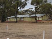
The Northam Army Camp covers an area of 202 ha (refer map on Pg 4 of this form), and has basic facilities for 500 people accommodated in huts (built between 1939-45), and 1000 in tents. A supply depot storehouse can hold provisions for 1500, and the septic system and ablution facilities can handle the same volume. The large storage areas provide 4-5 acres of covered building. Also in the camp are a parade ground, two houses, an airstrip and a grave.
Once a very busy centre, there is now only one military employee, the caretaker, who lives on the premises. Between 1940 and about 1960 up to 40000 soldiers were trained in the camp, providing much needed income to the town when they used local businesses. During WWII Italian prisoners-of-war who were held at the camp built the parade ground, using local rocks. The flat area can also be used as a helicopter landing site. When the camp was in peak use there was a supportive infrastructure, with chaplains, a canteen, YMCA and a cinema. The airstrip is maintained and used by the RAAF. The camp is now used mainly by the ARES for annual camps, weekend training and recruit courses. It is also used periodically by the ARA and Cadets. At one time part of the camp was used to accommodate European migrants who came out to Northam after WWII in 1949. A study to determine the future use for the Northam Camp is nearing finalisation (late 1996).
Integrity: High Authenticity: High
Good
| Ref ID No | Ref Name | Ref Source | Ref Date |
|---|---|---|---|
| DS Garden; "Northam: An Avon Valley History". |
| Owner | Category |
|---|---|
| Commonwealth of Australia | Commonwealth Gov't |
This information is provided voluntarily as a public service. The information provided is made available in good faith and is derived from sources believed to be reliable and accurate. However, the information is provided solely on the basis that readers will be responsible for making their own assessment of the matters discussed herein and are advised to verify all relevant representations, statements and information.
Lockyer Rd Clackline
Viaduct
Northam
Avon Arc
Constructed from 1990, Constructed from 1935
| Type | Status | Date | Documents |
|---|---|---|---|
| Heritage List | Adopted | 19 Feb 2020 | |
| State Register | Registered | 18 Nov 2008 | HCWebsite.Listing+ListingDocument, HCWebsite.Listing+ListingDocument |
| Type | Status | Date | Documents |
|---|---|---|---|
| (no listings) |
| Type | Status | Date | Grading/Management | |
|---|---|---|---|---|
| Category | ||||
| Municipal Inventory | Adopted | 25 Feb 1998 | ||
| Statewide Lge Timber Str Survey | Completed | 11 Dec 1998 | ||
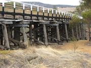
03858 Clackline to Toodyay Railway Formation (1888)
The bridge remains as an operational bridge on a major highway. It is essentially a timber structure requiring continuing maintenance and is generally in good condition.
| Library Id | Title | Medium | Year Of Publication |
|---|---|---|---|
| 6876 | Toodyay-Clackline heritage trail : management plan. | Report | 1998 |
Other Built Type
| Epoch | General | Specific |
|---|---|---|
| Present Use | Transport\Communications | Road: Bridge |
| Original Use | Transport\Communications | Road: Bridge |
| Type | General | Specific |
|---|---|---|
| Other | TIMBER | Other Timber |
| General | Specific |
|---|---|
| TRANSPORT & COMMUNICATIONS | Road transport |
| OCCUPATIONS | Timber industry |
| SOCIAL & CIVIC ACTIVITIES | Community services & utilities |
| DEMOGRAPHIC SETTLEMENT & MOBILITY | Technology & technological change |
This information is provided voluntarily as a public service. The information provided is made available in good faith and is derived from sources believed to be reliable and accurate. However, the information is provided solely on the basis that readers will be responsible for making their own assessment of the matters discussed herein and are advised to verify all relevant representations, statements and information.
Constructed from 1990, Constructed from 1935
The Clackline Bridge has aesthetic significance as an example of an early timber road bridge. It has scientific significance, owing to its construction on a horizontal curve at a gradient. It would be of high value for the bridge to be included on heritage trails for its unusual design and the vistas it provides over the surrounding countryside.
The Clackline Road Bridge was constructed over the Clackline Brook using timber as the structural element to the following design: Length 126.35m Width 9.10m Max headroom 5.49m Skew 37˚ No of spans 18 Constructed on a significant grade The Bridge was widened in 1960 and a concrete overlay to the deck was added in 1978. Clackline Bridge is a curved timber road bridge with a one in twenty gradient constructed in 1935 on the Great Eastern Highway, immediately east of the village of Clackline. The structure is 126.35 metres in length and 8.8 metres wide and was built over the Eastern Railway line and the Clackline Brook gully. Length - 126.35 m, width 9.10m, max headroom 5.49m, skew 37 degrees, number of spans 18. The Clackline Road Bridge is very unusual, possible unique in WA, in that it was constructed on a horizontal curve and at a gradient. The fully timbered bridge was also an early exercise in grade separation, a previously the railway and Great Eastern Highway met at this location with poor visibility due to terrain. With the added hazard of the intersection being close to a town site, a high degree of conflict would have been expected, hence the widening in 1960. A recent realignment of Great Eastern Highway means that the bridge is no long part of the highway.
The Guildford-Spencers Brook-Northam rail line passed under the west end of the bridge until 1981. The track was removed in 1984 and the footpath was removed in 1992 following severe accident damage late in 1991. The bridge was almost destroyed by bushfire because of heavy undergrowth, after which the bridge was repaired.
Integrity: High Authenticity:since widened following construction in 1935, and a concrete deck installed over the timber decking, the integrity of the original bridge is still maintained, high authenticity and continues to demonstrate the technology of constructing a curved and sloping road bridge
Remains an operational bridge
| Name | Type | Year From | Year To |
|---|---|---|---|
| E.W. Godfrey (engineer), MRWA 608 | Architect | - | - |
| Owner | Category |
|---|---|
| Main Roads WA | State Gov't |
This information is provided voluntarily as a public service. The information provided is made available in good faith and is derived from sources believed to be reliable and accurate. However, the information is provided solely on the basis that readers will be responsible for making their own assessment of the matters discussed herein and are advised to verify all relevant representations, statements and information.
1950 Nabawa East Bowes
Chilimony Bowes
Knockbrack
Northampton
Midwest
Constructed from 1850
| Type | Status | Date | Documents |
|---|---|---|---|
| Heritage List | Adopted | 15 May 2020 | |
| State Register | Registered | 06 Sep 1996 | HCWebsite.Listing+ListingDocument |
| Type | Status | Date | Documents |
|---|---|---|---|
| (no listings) |
| Type | Status | Date | Grading/Management | |
|---|---|---|---|---|
| Category | ||||
| Municipal Inventory | Adopted | 19 Apr 1996 | Category 1A | |
| Library Id | Title | Medium | Year Of Publication |
|---|---|---|---|
| 5753 | Homesteads of the mid west region of Western Australia. | Book | 1997 |
| 11712 | The Bowes (Knockbrack) Northampton, Western Australia | Heritage Study {Cons'n Plan} | 2019 |
| 9407 | The Bowes - final report. | Conservation works report | 2009 |
| 621 | Four homesteads: Oakabella, the Bowes (Knockbrack),Willi Gulli and Trevenson, Northampton District. | Heritage Study {Other} | 1995 |
| 7146 | The Bowes, Northampton, Western Australia : conservation works (final report). | Conservation works report | 2004 |
Individual Building or Group
| Epoch | General | Specific |
|---|---|---|
| Original Use | FARMING\PASTORAL | Homestead |
| Original Use | FARMING\PASTORAL | Shed or Barn |
| Present Use | FARMING\PASTORAL | Homestead |
| Style |
|---|
| Victorian Georgian |
| Type | General | Specific |
|---|---|---|
| Wall | STONE | Other Stone |
| Roof | METAL | Corrugated Iron |
| Wall | RENDER | Cement Dressed |
| General | Specific |
|---|---|
| OCCUPATIONS | Grazing, pastoralism & dairying |
| PEOPLE | Early settlers |
This information is provided voluntarily as a public service. The information provided is made available in good faith and is derived from sources believed to be reliable and accurate. However, the information is provided solely on the basis that readers will be responsible for making their own assessment of the matters discussed herein and are advised to verify all relevant representations, statements and information.
Constructed from 1860
'The Bowes' Estate, its homestead, associated outbuildings and cemetery, is highly significant historically, socially and aesthetically for the role the property and its owners have played in the pioneering and development of the region and the State. The homestead buildings, shearing shed and cemetery are particularly significant for their condition, influence on similar buildings in the district and the important role the people associated with them have played both locally and throughout the State.
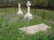
The Bowes Homestead is located on the Bowes River approx. 10 kms south east of Northampton on the Northampton - Nabawa Road. The homestead has a long rectangular floor plan, one room wide with lean-to enclosures to the rear and a long open verandah facing the river. The verandah is supported on timber posts and is an extension of the main, hipped, CGI roof over the homestead. French doors open from each room onto the verandah to catch the breeze and provide access. Originally, access between most rooms was gained using the verandah as an external 'passageway', although there appears to have been some direct access between several rooms as there is now. This was a common design format for the early homesteads of the period and it is said ' The Bowes', being the first, formed a model for the other large pastoral homesteads of the district such as Oakabella (Site No. 147) There are a collection of outbuildings adjacent to the homestead including the original separate kitchen and dining room with painted rendered stone walls (possibly originally limewashed) located off the rear verandah (now enclosed). These buildings now appear to be used as staff accommodation and provide something of a quadrangle around the back of the homestead which could have been intentional for security against aboriginal attack or ease of access. A little further away there is also a more recent managers house and several metal clad farm sheds. On the other side of the river from the homestead is a large, white painted, stone shearing shed with CGI roof. The shearing shed is elegantly proportioned with tall internal spaces punctuated with timber columns supporting the roof. It is located just off the Northampton-Nabawa Road near to where a railway siding, on the Geraldton- Northampton government line, originally serviced The Bowes. Further upstream from the homestead, and on the same side of the river is a small family cemetery. A stone retaining wall along the river bank to minimise the affects of flooding. The cemetery contains the graves of pioneer settlers and several prominent headstones remain intact. Fortunately, the graves have been protected from stock by a steel fence which although functional is too confining and somewhat unsympathetic in its design.
William Burges was the first permanent land settler in the Northampton District, establishing the first pastoral property there in 1850. Burges was born in 1807 in the little Irish town of Tipperary. In 1830 William, along with his brothers Samuel and Lockier Burges, arrived at Fremantle on the 'Warrior'. After their arrival the government made a grant of 1920 acres of land along the Swan River to William, the eldest of the three brothers. A little later a further grant of 3000 acres on the Avon River was made, followed by another 6000 acres. This property was named 'Tipperary' after their home town in Ireland. In 1848 Lockier Burges, the youngest of the three brothers, accompanied the A.C. and F.C. Gregory expedition which penetrated as far north as the Murchison River and confirmed the rich pastoral prospects of the land between the Irwin and Murchison Rivers. On his return to the York property Lockier Burges emphasised to his brothers the suitability for grazing of that country. Messrs William Burges and John Drummond visited the Geraldine Mine in November 1849, while at the same time evaluating the land thereabouts for pastoral potential. Both Burges and Drummond were impressed by what they saw. Consequently, in 1850 both William and Lockier Burges left 'Tipperary' and set off for the Champion Bay district with 2000 sheep and 200 head of cattle. The brothers were met at Dandaragan by Augustus and Henry Gregory who acted as guides while John Drummond went along as police escort of what became the town of Northampton, where William and Lockier took up a pastoral lease of 132 000 acres. Initially calling the property' Knockbrack' after his old home in Ireland, William eventually renamed the estate 'The Bowes' because of its position on the Bowes River. The Bowes was widely known as the centre of hospitality for those passing through the district. John Forrest, on his epic journey to Adelaide in 1874, wrote of the "hospitable residence of Thomas Burges. When the Geraldton-Northampton Railway was constructed 1874-1879, a siding was located at 'The Bowes', a quarter of a mile from the homestead. In July 1900 the partnership of WM & SL Burges was dissolved and the 100,000 acre lease was put up for sale. Bowes and Yuin were purchased by William Burges for 30,000 pounds in December 1900. In the early 1900s the Government made a decision not to renew pastoral leases in the area and much of The Bowes' was resumed and subdivided into 600 and 1000 acre farms. Many other large pastoral properties in the Victoria district, including Oakabella, Mt Erin and Narra Tarra, suffered the same fate. The Bowes Estate was reduced to 16 927 acres and in 1911 Thomas Drage purchased from the property from the Burges family. Elizabeth Drage, widow of Thomas Drage sold The Bowes in 1940 to the Lee Steere family who still control the property. As the first pastoral property in the Northampton District, The Bowes is representative of both the pastoral and agricultural industries as well as the significant influence of the Burges family in the development of the area. The private cemetery on the bank of the Bowes River contains the graves of members of this pioneer family. Chronology Entries 1850 William Burges moved from the Avon Valley to Champion Bay and established a pastoral tease called 'The Bowes'. Source Pages Ancient Landmarks, Bain, M. A., UWA Press, Perth, 1975 ISBN:0 85564 090 1 46 1853 William Burges wrote to the Governor, without success, seeking consideration for the right to crop land without tillage lease or payment of rent, and a lifting of the restrictions regarding the size and shape of cultivated paddocks. 1866 E. T. Hooley trekked from Champion Bay to Pt Walcott seeking a stock route. Source Pages E. T. Hooley, Pioneer Bushman, Sharp, E. I.„ 1985 ISBN:0 9588829 0 8 1874 John and Alexander Forrest's exploration party passed through the Northampton area amidst enthusiastic celebrations.
Integrity: High Modifications: Some enclosures and alterations Orig'l Fabric: Mostly intact
Good
| Ref ID No | Ref Name | Ref Source | Ref Date |
|---|---|---|---|
| "Fire guts historic cottage" | Geraldton Guardian | 14/02/1996. | |
| BL Acc 1133 B/45 | Photograph; "Bowes" Station showing the homestead owned by William Burges,". | Battye Library | 1900 |
| BL Acc 4010 B, c.r. 67714 P - 6716 P | Photograph: "the Bowes' Homestead,,". | Battye Library | 1927 |
| BL Acc 3379 B | Photograph; "the Bowes' Homestead, front view,e". | Battye Library | 1967 |
| BL Acc 994.12 | Bain, M.A; "Ancient Landmarks: A Social and Economic History of the Victoria District of Western Australia, 1839-1894". | UWA Press | |
| BL Acc 816 BIB 509-510 | Photograph: "the Bowes' Homestead,,". | Battye Library | 1929 |
| Feilman & Associates; "A Survey of Places of Historic and Landscape Significance in Northampton, Dongara, Geraldton, WA", | 1977 | ||
| Considine & Griffiths; "The Four Homesteads" | 1994 |
| Owner | Category |
|---|---|
| Lee Steere Pty Ltd | Other Private |
This information is provided voluntarily as a public service. The information provided is made available in good faith and is derived from sources believed to be reliable and accurate. However, the information is provided solely on the basis that readers will be responsible for making their own assessment of the matters discussed herein and are advised to verify all relevant representations, statements and information.
off Warribanno Chimney Rd Galena
Situated on the Murchison River about 5 km downstream from the Murchison River Bridge on the North West Coastal Highway. Original workings on N bank also shafts in river. Newer workings on S side of river. Inc Kilally (Coolally) homestead and graveyard north of the mine site.
Geraldine Mine Site, Buildings and Graveyard
Northampton
Midwest
Constructed from 1849 to 1960
| Type | Status | Date | Documents |
|---|---|---|---|
| Heritage List | Adopted | 15 May 2020 | |
| State Register | Registered | 04 Aug 1998 | HCWebsite.Listing+ListingDocument, HCWebsite.Listing+ListingDocument |
| Type | Status | Date | Documents |
|---|---|---|---|
| (no listings) |
| Type | Status | Date | Grading/Management | |
|---|---|---|---|---|
| Category | ||||
| Aboriginal Heritage Sites Register | Interim | |||
| Register of the National Estate | Indicative Place | |||
| Municipal Inventory | Adopted | 19 Apr 1996 | Category 1A | |
15875 Galena Heritage Area
| Library Id | Title | Medium | Year Of Publication |
|---|---|---|---|
| 6322 | The technology of colonial ore processing in Western Australia : the Warribanno Lead Smelter. | Journal article | 1997 |
| 9051 | Galena mine field archaeological report. | Heritage Study {Other} | 2008 |
| 11815 | Henderson & Coy : Royal Engineers & the Convict Establishment Fremantle Western Australia 1850 - 1872 | Book | 2017 |
| 11569 | Landscapes of Redemption: Tracing the path of a Convict Miner in Western Australia | Heritage Study {Other} | 2010 |
| 2398 | National Estate Program : documentation of geological sites and monuments; Nomination of geological monument for the register of the National Estate: Dingo Gap, Bugle Gap, Bringo Railway cutting, Molecap Hill, Veevers Crater, Dalgaranga Crater, North Pole, | Report | 1989 |
| 3845 | Galena Mining Heritage : conservation plan. | Heritage Study {Cons'n Plan} | 1998 |
Other Built Type
| Epoch | General | Specific |
|---|---|---|
| Original Use | MINING | Other |
| Present Use | VACANT\UNUSED | Vacant\Unused |
| Style |
|---|
| Other Style |
| General | Specific |
|---|---|
| DEMOGRAPHIC SETTLEMENT & MOBILITY | Resource exploitation & depletion |
| DEMOGRAPHIC SETTLEMENT & MOBILITY | Settlements |
| OCCUPATIONS | Mining {incl. mineral processing} |
This information is provided voluntarily as a public service. The information provided is made available in good faith and is derived from sources believed to be reliable and accurate. However, the information is provided solely on the basis that readers will be responsible for making their own assessment of the matters discussed herein and are advised to verify all relevant representations, statements and information.
Constructed from 1849
1993 The site is very significant historically and scientifically for its role in the development of the region and the beginnings of mining in Western Australia. 2004 Geraldine Lead Mine, an archaeological and geological site with ruins and machinery remnants, has cultural heritage significance for the following reasons: •the Mine was the first commercial mining venture in Western Australia; •the Mine represents the early aspirations of the Swan River colony for economic independence; •the place contains ruins of some of the oldest buildings in the region and as such, it has the potential to yield invaluable information about how early settlers coped with living in an isolated environment and how they lived during this period. The place also contains remnants of mine shafts, machinery (including parts of an early steam traction engine), engine houses, knapping or ore-breaking floor, mine manager's house (Collally), cemetery and ore processing remains; •the Mine, together with early pastoral activity, was responsible for opening up the Murchison and Victoria districts and led to the establishment of Geraldton (Champion Bay) and Port Gregory; •the ore breaking floor and the arrangement of compounds and associated buildings have not been found on other mining sites in Western Australia; •the place contains vital information about early mining practices in the state of Western Australia; •the Mine is socially important for the people of Northampton who identify the site as an important component of their local heritage; as part of a cultural landscape, the place has aesthetic value due to its location on the banks of the Murchison River; and, •the place is associated with the convict period of history, convict labour and the important archaeological site at the failed convict hiring depot at Lynton, with which it shares a common history.
1993 Site and ruins of the first lead mine in the State. Ruins north of the river include the mine office and manager's house and the Knapping floor. On the south bank are the remains of further buildings, possibly miners accommodation. (Carter, J.D. 1987, Important Geological Localities in Western Australia.) The stone walls of a large building (thought to be the engine room-ref Cumming, D.) associated with the mine still stand adjacent to the stone paved ore breaking floor alongside the river. The building appears to have the remnants of mountings built into the floor for some sort of equipment. A low stone wall provides a small fenced paddock on one side of the building. Some industrial archaeological examination would assist in identifying various components of the site. There are also collapsed and filled tunnels, and mine workings underground. Fifty metres to the north are the stone ruins of the Kilally buildings, walled paddocks and a cemetery (see Site No. 8). 2004 For the full description see the Heritage Council Register documentation. See also Gibbs 1998. The oldest structures on the site are located on slightly elevated ground on the western side of the Murchison River. These comprise the Engine House and associated compound, ore breaking floor, Mine Manager's House and compound and the cemetery. The 1960s ore processing site is located on rising ground on the eastern side of the river. The structures on the eastern side of the river are located in a cleared area with some re-growth of natural vegetation, surrounded by mullock heaps. The Engine House is constructed from random rubble laterite stone walling held together with mud mortar. The southern wall is the most intact wall and is punctuated with two window openings either side of a centrally located door. Timber lintels are still insitu. A large portion of the eastern wall remains and is punctuated with one window opening. There is no evidence of flooring material or roofing members, although there is evidence of two raised sections of flooring or engine mountings at the eastern end of the building. North of the building, are the remains of stone walls which appear to have formed an enclosed compound (with the Engine House forming the southern boundary), together with small rooms opening into the compound. These rooms are located along the northern and eastern walls of the compound. During the current survey no artifactual scatters were noted, although the remains of a boiler were found abandoned in the compound. No determination was made as to whether this was part of the steam traction engine mentioned in the documentary evidence. On the southern side of the Engine House is the ore breaking floor. This area has been carefully levelled and laid with stones. Portions of the floor have fallen away on the western and southern sides. Foundations were also noted for other buildings/structures located between the knapping floor and the Engine House, on the southern edge of the floor and also on the western side of the floor. The Mine Manager's House is located north of the Engine House and is constructed in a similar fashion, laterite stone walls with finished joints, and lime applied to the exterior and interior wall surfaces. The walls are in a more ruinous condition than those of the Engine House. This building also has a large compound enclosed by a stone wall. Like the Engine House compound, small rooms appear to have been constructed within the compound corners. A stone cairn, erected by the CWA in 1979, is located in the middle of the compound. The cemetery is located slightly to the north of the Mine Manager's House. The historical record indicates that other buildings, dating from the original workings (1851), were located on the eastern side of the river. The ore processing remains on the eastern side of the river date from the 1960s when the mine was briefly reopened. These remains consist of concrete aprons together with concrete foundations and steel frameworks (Photos NR007-02 to NR007-4). Adjacent to the concrete aprons are numerous mullock heaps which appear to be chronologically related to the concrete and steel structures. Fifty metres to the north are the stone ruins of the Kilally buildings, walled paddocks and a cemetery (see Site No. 8).
1993 Mr Walcott, a member of the Gregory exploration party of 1848, found some specimens of galena (lead ore) in the bed of the Murchison River. Further investigation revealed that the lead existed in abundant quantities. Following an examination of the site by the Governor, His Excellency Charles Fitzgerald, he enthusiastically encouraged the exploitation of the lead finds. As a result the Geraldine Lead Mine, under the control of Mr Lockier C. Burges, began operations in 1849. The Geraldine Mining Company arranged for F. Pearson to build a smelting works nearby, the chimney of which still stands. (Site No. 9). Mine Captains at the Geraldine included L.C. Burges in 1849, Capt. James in 1850, Martin Hosken in 1853 and Samuel Mitchell between 1867 and 1875. The flooding of the Murchison River on several occasions, the hazards of Port Gregory for shipping and the fluctuations of the world mineral market resulted in the mine enjoying mixed fortunes. Abandoned in 1875, the Geraldine was reopened in 1910 and over the following 12 years, yielded 774 tons of ore containing 275 tons of lead worth 5739 pounds. 2004 For the full history see the Heritage Council Register documentation. See also Gibbs 1998. The place is composed of a number of structures, some of which are not fully documented at present. To date, structures identified on the site include: the Engine House (c.1851), Mine Manager's House (c.1851), Ore breaking floor (c.1851), Cemetery (c.1854), Mine Shafts (1849), and the Ore processing site (c.1960s). In 1846, Augustus Gregory, then a member of the Colonial Government's Survey Department, had discovered brown coal along the Irwin River in the previously unexplored mid-west region of Western Australia. In 1848, Gregory, together with his brother Charles and a group of settlers including pastoralist Lockier Burges, made a second expedition northward, discovering galena (lead sulphide) in the bed of the Murchison River, as well as viable pastoral land along the Bowes River. After several months during which the land failed to sell, an auction was held and 640 acres acquired by the newly founded Geraldine Mining Company, the first of several companies to bear the name. As the mine site was far removed from the relative safety of Perth, the government initially provided the enterprise with a detachment of 25 soldiers and a promise to establish a boat harbour (Champion Bay) to facilitate the shipment of the ore. Under the direction of Lockier Burges, operations commenced at the mine in December 1849 and the first shipment of 5 tons of ore was brought back to Champion Bay on the 22 December. Lockier Burges, who was unhappy with the location of the mine shaft in the river bed, left as mine manager in 1850 and was replaced by Captain James. It was soon realised that it would be more efficient to transport smelted lead for shipment and in 1851, Francis Pearson, an experienced smelter from Newcastle-upon-Tyne, arrived from England with his family. He immediately set about constructing a temporary trial smelter at Geraldine Lead Mine. In 1853, yet another mine manager was appointed, Martin Hoskin. He complained that the mine was not as productive as it might have been due to years of mis-management and inadequate equipment. Over the years the Blue Books record the amount of lead extracted from the mine which appears to have been quite productive, although due to the unusual location of the mine in the bed of the Murchison River, operations were often interrupted when the river flooded. Progress over the following years can be traced through the annual Blue Book reports, which indicate a fluctuating production between 1853 and 1860, varying from 55 to 134 tons per annum. Although there is information about the lead yields from Geraldine Lead Mine, there is little documentary evidence relating to the actual structures built on the site or the numbers of men employed there or their living conditions. However, the number of convicts and ticket-of-leave men employed on the site is recorded. The mining company managed to obtain 60 men from Cornwall and the North Country who were experienced miners. In 1856, Geraldine Lead Mine was offered for sale and the prospectus that was prepared for this sale offers tantalising information about the site. Pumps and machinery are put up, but a small engine will be necessary, in order to do away with the costly horse-power at present employed Good cottages, stores, smithy, and all necessary buildings connected with the mine, are erected Between 1860 and 1863, the Blue Books list Geraldine Lead Mine as 'not working'. Under the ownership of Robert Habgood, mining recommenced in 1864/65 and in 1866 Habgood brought out Cornishman Samuel Mitchell, an experienced mine manager. This was Geraldine Lead Mine's most productive phase which lasted until 1878, when Habgood died, leaving the estate entailed. Geraldine Lead Mine did not open again until 1917. During 1917-1918 the Geraldine was briefly worked by Harry Gallagher, and during the 1960s the Mine was purchased by Joe Plaistow; however, the shafts were not extensively worked. During this brief period of occupancy, a lead ore processing site was constructed on the eastern side of the Murchison River. Geraldine Lead Mine has effectively lain idle since this time. During the early occupancy of the place, a cemetery was established which contains four headstones dating from 1854 to 1870. Chronology Entries 1848 An exploration party lead by A. C. Gregory found lead ore on the banks of the Murchison River and good pastoral country in the hinterland of Champion Bay, at the Hutt and Bowes Rivers. 1849 The Murchison River was classified as mineral land and the Geraldine Mining Company was founded with Lockier Burges as the Mine Manager. The Geraldine Mine is believed to have been one of the first mines in Australia. The first lead was exported from the Geraldine Mine. Source Pages Ancient Landmarks, Bain, M. A., UWA Press, Perth, 1975 ISBN:0 85564 090 1 34 1851 Francis Pearson, a smelter tradesman, his wife Mary Anne and their family settled near the Geraldine Mine area. For the next five years, the Pearsons were the only European family living in the locality. Pearson built the smelters to service the Geraldine Mine. The Warribanno Chimney was completed. 1851 Governor Hampton offered the people of the Geraldine mine a wooden house and the protection oi 25 soldiers. 1851 22 ticket-of-leave men were working at the Geraldine Mine and with Government Surveyors in the district. 20/11/1854 Surveyor Robert Austin and party arrived at the Geraldine Mine after an exploratory trip to tine north and east of the settled districts. 1866 E. T. Hooley trekked from Champion Bay to Pt Walcott seeking a stock route. Source Pages E. T. Hooley, Pioneer Bushman, Sharp, E. I.„ 1985 ISBN:0 9588829 0 8 1867 Captain Samuel Mitchell arrived from Cornwall to manage the Geraldine Mine.
Integrity: Low Modifications: Dismantled Mine
Poor
| Ref ID No | Ref Name | Ref Source | Ref Date |
|---|---|---|---|
| Bain, M.A; "Ancient Landmarks". | UWA Press | 1975 | |
| Gibbs, M; "A preliminary archaeological survey of the Geraldine Lead Mine, Ajana Western Australia. Northampton Archaeological Survey". | Dr Martin Gibbs and the Archaeological Society of Western Australia, unpublished | 1997-98 | |
| Clydesdale, J; "Fuel tank clue to Australia's first roadtrain". | Sunday Times | 13/9/1995 | |
| Lowrie, J; "Notes for C.W.A. Radio Sessions on 6GE". | Unpublished | 1979 | |
| Considine & Griffiths; "Warribanno Lead Smelter Complex; Conservation Plan". | Considine & Griffiths | ||
| Kelly, G. J; "History of Mining in the Geraldton District' in Early Days". Vol. 8, Pt 1, | 1962 | ||
| Considine & Griffiths; "Lynton Heritage Conservation Plan". | Considine & Griffiths | ||
| Carter, J.D; "Important Geological Localities in Western Australia." | 1987 | ||
| Cumming, D; "Preliminary Notes on the Northampton Mineral Field". | 1994 | ||
| Considine & Griffiths; "Warribanno Lead Smelter Complex'". | Considine & Griffiths | 1995 | |
| Galena Management Plan Steering Committee; "Galena Mining Heritage Area Management Plan". | Shire of Northampton. | ||
| Lowth, S; "A History of the Geraldine Lead Mine' Australian Studies III". | Unpublished | ||
| Kelly, G. J; "History of Mining in the Geraldton District' in Early Days". Vol. 6, Pt 1, | 1962 |
This information is provided voluntarily as a public service. The information provided is made available in good faith and is derived from sources believed to be reliable and accurate. However, the information is provided solely on the basis that readers will be responsible for making their own assessment of the matters discussed herein and are advised to verify all relevant representations, statements and information.
Gwalla St Gwalla
Northampton
Midwest
Constructed from 1863
| Type | Status | Date | Documents |
|---|---|---|---|
| (no listings) |
| Type | Status | Date | Documents |
|---|---|---|---|
| (no listings) |
| Type | Status | Date | Grading/Management | |
|---|---|---|---|---|
| Category | ||||
| Municipal Inventory | Adopted | 19 Apr 1996 | Category 1A | |
| Municipal Inventory | Adopted | 19 Apr 1996 | Category 1A | |
01902 Church & Cemetery, Gwalla
Landscape
| Epoch | General | Specific |
|---|---|---|
| Original Use | MONUMENT\CEMETERY | Cemetery |
This information is provided voluntarily as a public service. The information provided is made available in good faith and is derived from sources believed to be reliable and accurate. However, the information is provided solely on the basis that readers will be responsible for making their own assessment of the matters discussed herein and are advised to verify all relevant representations, statements and information.
Constructed from 1863
The Gwalla Cemetery is significant socially and historically as the first interdenominational cemetery in Northampton as well as for its associations with prominent people buried there. It is an integral part of the Gwalla Precinct, which includes the adjacent Gwalla Church, the mine site, ruins of Horrocks' stone walls, the site of the first railway station, stone cottage ruins, as well as stone and CGI miners' cottages.
The walled cemetery has 1.2m (4ft) high stone perimeter walls that sweep up high to pillars either side of timber entry gates. The walls have been built in Horrocks' style [See Site No. 137], but with smooth rendered capping. Attempts have been made to stabilise walls by renovating capping, unfortunately using grey cement which is unsympathetic to the natural stone and capping. There are an interesting variety of headstones and fencing styles to graves. One of the most significant marked graves is Horrocks', with a brick tomb above the ground.. A stone obelisk just inside the entry gates commemorates the early pioneers and was unveiled by the Honourable David Brand in 1964.
The Gwalla Cemetery, the oldest of the three cemeteries in Northampton was opened for burial in 1861. Like the Gwalla Church, the cemetery was non-sectarian and contains the graves of many early pioneers, including 'Dr' Joseph Horrocks, Captain Samuel Mitchell, his wife and son. Mitchell was a manager at the Geraldine Mine [Site No. 7], before living at Chiverton House [Site No. 107] Martin Hosken is also buried in the cemetery. He was the owner of the Mining Arms [Site No. 60] and the Railway Hotel [Site No. 104]. Chronology Entries 07/10/1865 Death of Joseph. Horrocks at the age of 55. 07/1912 Death of Captain Samuel Mitchell.
Integrity: Low
Fair
| Ref ID No | Ref Name | Ref Source | Ref Date |
|---|---|---|---|
| BL Acc 4396 B/18 | Photograph: "Memorial at Gwalla Cemetery,". | Battye Library | 1969 |
| GHS3925 | Photograph; "memorial". | Northampton Historical Society, | 1964 |
| BL Acc 994.12 | Bain, M.A; "Ancient Landmarks: A Social and Economic History of the Victoria District of Western Australia, 1839-1894". | UWA Press | 1975 |
| Drew, J.M., "Early Northampton: An Undenominational Church", Early Days, Vol.2, No. 2. | 1932 | ||
| Considine and Griffiths Architects Pty Ltd; "Gwalla Precinct, Northampton Conservation Plan". | Shire of Northampton | 200 | |
| Palassis; "Northampton Character Study". | |||
| Considine & Griffiths Architects Pty Ltd; "Gwalla Cemetery Preliminary Conservation Report" | Shire of Northampton | 1998 | |
| Feilman & Associates, "A Survey of Places of Historic and Landscape Significance in Northampton, Dongara, Geraldton, WA", | 1977 |
| Owner | Category |
|---|---|
| Shire of Northampton | Local Gov't |
This information is provided voluntarily as a public service. The information provided is made available in good faith and is derived from sources believed to be reliable and accurate. However, the information is provided solely on the basis that readers will be responsible for making their own assessment of the matters discussed herein and are advised to verify all relevant representations, statements and information.
866 Dumbarton Rd Irishtown
Includes Workman's accommodation & Mill Barn
Northam
Avon Arc
Constructed from 1840 to 1970
| Type | Status | Date | Documents |
|---|---|---|---|
| Heritage List | Adopted | 19 Feb 2020 | |
| State Register | Registered | 18 Mar 2005 | HCWebsite.Listing+ListingDocument, HCWebsite.Listing+ListingDocument |
| Type | Status | Date | Documents |
|---|---|---|---|
| (no listings) |
| Type | Status | Date | Grading/Management | |
|---|---|---|---|---|
| Category | ||||
| Municipal Inventory | Adopted | 25 Feb 1998 | ||
| Classified by the National Trust | Classified | 05 May 1980 | ||
| Register of the National Estate | Permanent | 28 Sep 1982 | ||
The various components of Bardeen Homestead Group are in varying condition, from semi-ruinous to mostly fair condition.
| Library Id | Title | Medium | Year Of Publication |
|---|---|---|---|
| 7915 | Toodyay homesteads: past and present. | Book | 2006 |
| 9240 | Bardeen - final report | Conservation works report | 2009 |
| 7755 | Bardeen homestead, Irishtown (via Northam): conservation works. | Conservation works report | 2006 |
| 7534 | Bardeen Homestead, Irishtown : conservation works (final report). | Conservation works report | 2005 |
| 6746 | Conservation plan for Bardeen homestead. | Heritage Study {Cons'n Plan} | 2004 |
| 7535 | Bardeen Homestead - Stables, Irishtown, WA : structural report. | Heritage Study {Other} | 2004 |
Individual Building or Group
| Epoch | General | Specific |
|---|---|---|
| Original Use | RESIDENTIAL | Single storey residence |
| Original Use | RESIDENTIAL | Two storey residence |
| Original Use | FARMING\PASTORAL | Kitchen |
| Original Use | MONUMENT\CEMETERY | Grave |
| Present Use | RESIDENTIAL | Single storey residence |
| Original Use | FARMING\PASTORAL | Cottage |
| Original Use | FARMING\PASTORAL | Other |
| Original Use | FARMING\PASTORAL | Silo or Grain Shed |
| Original Use | FARMING\PASTORAL | Homestead |
| Style |
|---|
| Victorian Georgian |
| Type | General | Specific |
|---|---|---|
| Wall | METAL | Corrugated Iron |
| Roof | METAL | Corrugated Iron |
| Wall | STONE | Local Stone |
| Wall | BRICK | Common Brick |
| General | Specific |
|---|---|
| DEMOGRAPHIC SETTLEMENT & MOBILITY | Settlements |
| DEMOGRAPHIC SETTLEMENT & MOBILITY | Land allocation & subdivision |
| PEOPLE | Early settlers |
| OCCUPATIONS | Grazing, pastoralism & dairying |
This information is provided voluntarily as a public service. The information provided is made available in good faith and is derived from sources believed to be reliable and accurate. However, the information is provided solely on the basis that readers will be responsible for making their own assessment of the matters discussed herein and are advised to verify all relevant representations, statements and information.
Constructed from 1940, Constructed from 1970
Bardeen homestead is built on the property which is the only land in the Northam district still occupied by the family of the original 1836 grantees. It therefore has a great deal of historical significance. It has social significance owing to its link to the Morgan family who have contributed to the local community and to the Shire over the last 160 years.
The Bardeen Homestead was built as a two storey brick building with single storey living quarters. There was a separate one roomed kitchen where a cook provided meals for the family and workmen. The original 14 x 12 ft stone cottage, built around 1840, was incorporated in the later house. The brick homestead constructed in 1858 was thought to be one of the earliest brick buildings in the district. An impressive stone granary (circa 1872) still contains a flour mill and horse works.
Bardeen has been owned by the Morgan family since it was allocated as part of an original land grant to Abraham Morgan in 1836. When Abraham Morgan died in 1871 he was succeeded by William John (1845-1924). After William’s death Bardeen was divided into two, the Bardeen Homestead block and another portion called Lynwood. In the lead up to WWI, when Northam prepared for the war efforts, annual camps for the infantry and light horse troops were held at Katrine and Bardeen. The Morgans have been influential in the development of the Katrine and Irishtown district over the years. Abraham Morgan was one of the builders of St Saviour’s Church at Katrine in 1862 and in modern period Doug Morgan has been influential in Shire affairs.
Integrity: High Authenticity: infill to the homestead verandahs is of low authenticity. Overall, the place has high authenticity
| Ref ID No | Ref Name | Ref Source | Ref Date |
|---|---|---|---|
| DS Garden; "Northam: An Avon Valley History". | |||
| Extracts from WJ Morgan’s Journal |
| Owner | Category |
|---|---|
| Bardeen Nominees Pty Ltd | Other Private |
This information is provided voluntarily as a public service. The information provided is made available in good faith and is derived from sources believed to be reliable and accurate. However, the information is provided solely on the basis that readers will be responsible for making their own assessment of the matters discussed herein and are advised to verify all relevant representations, statements and information.
Grey Rd Lynton/Port Gregory
Northampton
Midwest
| Type | Status | Date | Documents |
|---|---|---|---|
| (no listings) |
| Type | Status | Date | Documents |
|---|---|---|---|
| (no listings) |
| Type | Status | Date | Grading/Management | |
|---|---|---|---|---|
| Category | ||||
| Municipal Inventory | Adopted | 19 Apr 1996 | Category 4A | |
01915 Lynton Convict Hiring Depot (Ruins)
Historic Site
| Epoch | General | Specific |
|---|---|---|
| Present Use | INDUSTRIAL\MANUFACTURING | Other |
| Original Use | INDUSTRIAL\MANUFACTURING | Other |
| General | Specific |
|---|---|
| DEMOGRAPHIC SETTLEMENT & MOBILITY | Settlements |
| OCCUPATIONS | Manufacturing & processing |
This information is provided voluntarily as a public service. The information provided is made available in good faith and is derived from sources believed to be reliable and accurate. However, the information is provided solely on the basis that readers will be responsible for making their own assessment of the matters discussed herein and are advised to verify all relevant representations, statements and information.
The site of the lime kilns and quarry may have some local historic and scientific significance as an early secondary industry and in its role in the development of the district.
The lime kiln site, with a quarry also in a similar locale, is located nearby the ruins of the Pensioner Guard cottages. The lime kiln is a rough circular shape of about 3.9m diameter with standing walls of about 0.9 to 0.68m thickness, with a draught hole opening in the south-west side of the circle. The circle is built partly into the slope of the hill to assist easy loading.
The lime kiln & quarry is believed to have been used in the construction of the various buildings which made up the Lynton Hiring Depot (Site No. 25), Sanford's House (Site No. 26) and the Pensioner Guards Cottages (Site No. 27). The lime kiln is mentioned in the inspection report of April 1854.
Integrity: Low
Poor
| Ref ID No | Ref Name | Ref Source | Ref Date |
|---|---|---|---|
| GHS5514 | Photograph; "Lime Kiln". | 1942 | |
| GHS5888 | Photograph; "Lime Kiln". | 1940 | |
| GHS3054 | Photograph; "Lime Kiln". | Undated | |
| GHS6195 | Photograph; "Lime Kiln". | 1972 |
This information is provided voluntarily as a public service. The information provided is made available in good faith and is derived from sources believed to be reliable and accurate. However, the information is provided solely on the basis that readers will be responsible for making their own assessment of the matters discussed herein and are advised to verify all relevant representations, statements and information.
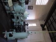
Mundaring
P25251 Goldfields Water Supply Scheme is part of this place and is on the National Heritage List. Starts in Mundaring, at Mundaring Weir and travels through the Shires of Mundaring, Northam, Cunderdin, Tammin, Kellerberrin, Merredin, Westonia, Yilgarn, Coolgardie and Kalgoorlie-Boulder.
Golden Pipeline
Mundaring
Metropolitan
Constructed from 1898
| Type | Status | Date | Documents |
|---|---|---|---|
| State Register | Registered | 08 Dec 2022 | HCWebsite.Listing+ListingDocument, HCWebsite.Listing+ListingDocument |
| Type | Status | Date | Documents |
|---|---|---|---|
| (no listings) |
| Type | Status | Date | Grading/Management | |
|---|---|---|---|---|
| Category | ||||
| (no listings) | ||||
25251 Goldfields Water Supply Scheme (NHL)
• The place is an excellent example of an initiative by the Western Australian Government to provide water to the Goldfields at the turn of the century.
• The place is rare as one of the largest pipelines in Western Australia, possibly the largest that supplies water.
• The place has aesthetic value as a landmark feature extending from Mundaring to Kalgoorlie.
• The place is rare and has scientific value as an innovative engineering design and construction method of a pipeline from the early 20th Century.
• The place is rare as a long-distance water pipeline in Australia built in the early 1900’s.
The Goldfields Water Supply Scheme, demonstrates exceptional technical achievement as one of the longest overland pipeline schemes attempted in the nineteenth century, both in Australia and the world, and was recognised as an outstanding engineering achievement; The has exceptional value in demonstrating the historical importance of the provision of water to settlements along the route from Mundaring to the Eastern Goldfields, The construction and operation of the Pipeline had considerable importance in contributing to the sense of place for the people of Western Australia, and visitors to the State, as a highly valued tourist destination, the educational, cultural and aesthetic aspects of which are appreciated by history and engineering enthusiasts and teachers to this day; Individual elements of the place, including the existing interpretation associated with the Golden Pipeline Heritage Trail, museums, archaeological sites and remaining buildings and infrastructure, collectively have exceptional potential to communicate the history of the Goldfields Water Supply Scheme and its importance to Western Australia; The place is associated with a number of notable figures in Western Australian history, including the Scheme's designer CY O'Connor, State and Federal politician Lord John Forrest, the Director of the Public Works Department HW Venn and former Superintendent of Public Works, architect George Temple Poole, who each contributed to the successful completion of the Goldfields Water Supply Scheme; and The place is an exceptional example of applied science, technical excellence and innovative design, reflecting the ongoing ingenuity and innovation demonstrated by the talented and committed engineers employed by the Goldfields Water Supply Branch, Public Works Department and other iterations of the Water Corporation in the provision of water in the State. The longevity of the scheme is associated with innovators Mephan Ferguson, James Couston, engineers Norman Fernie and Reg Keating, and James Mathers.
The Goldfields Water Supply Scheme extends in a discontiguous precinct across the 560km linear water pipeline, commencing at Mundaring Weir (1902, 1951) in the Helena Valley and terminating at Mount Charlotte Reservoir (1902) in Kalgoorlie-Boulder. Comprising six extant original Steam Pump Stations (1902) at Mundaring, Cunderdin, Merredin, Yerbillon, Ghooli and Dedari; the sites of two demolished Steam Pump Stations (1902) at O’Connor and Gilgai; Reservoirs and Tanks at O’Connor, Sawyers Valley, Bakers Hill, West Northam, Cunderdin, Merredin, Yerbillon, Ghooli, Bronti, Gilgai, Koorawawalyee, Dedari, Toorak, and Bullabulling; second generation Electric Pump Station at Merredin , and other community sites, ancillary structures; equipment and machinery, archaeological sites; and discontiguous portions of the main pipeline conduit associated with the construction and operation of the Scheme from 1902 to the present.
Phase I - Construction of the Goldfields Water Supply Scheme (1898 - 1903) Phase II – Problem Solving and Agricultural Expansion (1904 - 1940) Phase III – Comprehensive Water Supply Scheme, Upgrades & Refurbishments (1946 - 2013) Phase IV - Heritage Recognition and The Golden Pipeline (1992 - 2011)
High
Good
| Name | Type | Year From | Year To |
|---|---|---|---|
| Charles Yelverton O'Connor | Architect | 1898 | 1902 |
| Library Id | Title | Medium | Year Of Publication |
|---|---|---|---|
| 6452 | Mundaring Weir Precinct masterplan : final master plan report. | Heritage Study {Other} | 2002 |
| 7358 | Conservation plan for Goldfields Water Supply Scheme. Volume II, place M : No. 8 Pumping Station, Dedari. | Heritage Study {Cons'n Plan} | 1999 |
| 11426 | Goldfields Water Supply Volume III | Heritage Study {Cons'n Plan} | 1999 |
| 4897 | Conservation plan for Karalee Rock Water Catchment (Goldfields Water Supply Scheme - place J). | Heritage Study {Cons'n Plan} | 2000 |
| 7359 | Conservation plan for Goldfields Water Supply Scheme. Volume II, place N : Bullabulling reservoir. | Heritage Study {Cons'n Plan} | 1999 |
| 9248 | Constructing Australia: Triumphs and tragedies in building a nation. | C D Rom | 2007 |
| 6390 | Pipe-dream to pipeline : the eventful life of Nathaniel W. Harper. | Book | 2001 |
| 3680 | Conservation plan for No. 3 Pumping Station, Cunderdin. | Heritage Study {Cons'n Plan} | 1998 |
| 1774 | An exploratory bibliography of the Goldfields Water Supply of Western Australia (draft). | Report | 1982 |
| 4504 | Conservation plan for Mount Charlotte Reservoir (Goldfields water supply scheme - place O). | Heritage Study {Cons'n Plan} | 2000 |
| 11762 | Goldfields Water Supply Scheme, Main conduit, Western Australia | Heritage Study {Cons'n Plan} | 2016 |
| 6788 | Conservation plan for Koorarawalyee water catchment and railway station (Draft) (Goldfields Water Supply Scheme - place U). | Heritage Study {Cons'n Plan} | 2001 |
| 9806 | Mundaring Weir water Supply interpretation precinct design. | Book | 2010 |
| 7350 | Conservation plan for West Northam regulating tanks : (Goldfields Water Supply Scheme - place T) (draft). | Heritage Study {Cons'n Plan} | 2001 |
| 7356 | Conservation plan for Goldfields Water Supply Scheme. Volume II, place I : No. 6 Pumping Station, Ghooli. | Heritage Study {Cons'n Plan} | 1999 |
| 7547 | Celebrating 100 years of the Goldfields Water Supply Scheme. | Brochure | 2003 |
| 7354 | Conservation plan for Goldfields Water Supply Scheme. Volume II, place G : No. 4 Pumping Station, Merredin. | Heritage Study {Cons'n Plan} | 1999 |
| 7351 | Conservation plan for Toorak Hill reservoir : (Goldfields Water Supply Scheme - place V) (draft). | Heritage Study {Cons'n Plan} | 2001 |
| 7352 | Conservation plan for Goldfields Water Supply Scheme. Volume II, place A : No. 1 Pumping Station Mundaring. | Heritage Study {Cons'n Plan} | 1999 |
| 7348 | Conservation plan for Sawyers Valley summit tanks : (Goldfields Water Supply Scheme - place R) (draft). | Heritage Study {Cons'n Plan} | 2001 |
| 6675 | Mundaring Weir : conservation plan (draft). | Heritage Study {Cons'n Plan} | 2000 |
| 1608 | Conservation and interpretation plan for No.1 Pumping Station Mundaring. | Heritage Study {Cons'n Plan} | 1996 |
| 5988 | Centenary of the Goldfields Water Supply Scheme 1903-2003. | Brochure | 2003 |
| 7444 | The agricultural areas, Great Southern towns and Goldfields Water Supply Scheme : souvenir to commemorate the completion of the project. | Book | 1961 |
| 10170 | The origins of the Eastern Goldfields water scheme in Western Australia: an exercise in the interpretation of historical evidence. | Book | 1954 |
| 4644 | Conservation plan for Goldfields Water Supply Scheme : volume 1. | Heritage Study {Cons'n Plan} | 1999 |
| 7357 | Conservation plan for Goldfields Water Supply Scheme. Volume II, place K : No. 7 Pumping Station, Gilgai. | Heritage Study {Cons'n Plan} | 1999 |
| 8902 | River of steel. A history of the Western Australian Goldfields and Agricultural Water Supply 1903 - 2003. | Book | 2007 |
| 7355 | Conservation plan for Goldfields Water Supply Scheme. Volume II, place H : No. 5 Pumping Station, Yerbillon. | Heritage Study {Cons'n Plan} | 1999 |
| 7353 | Conservation plan for Goldfields Water Supply Scheme. Volume II, place B : No. 2 Pumping Station, O'Connor. | Heritage Study {Cons'n Plan} | 1999 |
| 7349 | Conservation plan for Bakers Hill regulating tank : (Goldfields Water Supply Scheme - place S) (draft). | Heritage Study {Cons'n Plan} | 2001 |
| 6794 | Conservation plan for Bullabulling township and railway catchment. (draft) : a supplement to the Bullabulling Reservoir conservation plan (Goldfields Water Supply Scheme - place N). | Heritage Study {Cons'n Plan} | 2001 |
| 9899 | Mundaring Weir water supply improvement project: heritage management strategy. | Heritage Study {Other} | 2011 |
| 6326 | The golden pipeline heritage trail guide : a time capsule of water, gold and Western Australia. | Book | 2002 |
| 4693 | Goldfields Water Supply heritage project. | Book | 1999 |
| 5544 | Golden Pipeline interpretation plan. | Heritage Study {Other} | 2001 |
Other Built Type
| Epoch | General | Specific |
|---|---|---|
| Original Use | GOVERNMENTAL | Power Station |
| Present Use | GOVERNMENTAL | Pumping Station |
| Present Use | EDUCATIONAL | Museum |
| Style |
|---|
| Vernacular |
| Type | General | Specific |
|---|---|---|
| Wall | BRICK | Common Brick |
| Wall | METAL | Steel |
| Roof | METAL | Corrugated Iron |
| General | Specific |
|---|---|
| SOCIAL & CIVIC ACTIVITIES | Community services & utilities |
| DEMOGRAPHIC SETTLEMENT & MOBILITY | Technology & technological change |
| DEMOGRAPHIC SETTLEMENT & MOBILITY | Resource exploitation & depletion |
| DEMOGRAPHIC SETTLEMENT & MOBILITY | Exploration & surveying |
This information is provided voluntarily as a public service. The information provided is made available in good faith and is derived from sources believed to be reliable and accurate. However, the information is provided solely on the basis that readers will be responsible for making their own assessment of the matters discussed herein and are advised to verify all relevant representations, statements and information.
87 Duke St Northam
Northam's Avon Descent Assoc. Headquarters
Northam
Avon Arc
Constructed from 1929 to 1955
| Type | Status | Date | Documents |
|---|---|---|---|
| Heritage List | Adopted | 19 Feb 2020 | |
| State Register | Registered | 24 Jun 2014 | HCWebsite.Listing+ListingDocument, HCWebsite.Listing+ListingDocument |
| Type | Status | Date | Documents |
|---|---|---|---|
| (no listings) |
| Type | Status | Date | Grading/Management | |
|---|---|---|---|---|
| Category | ||||
| Municipal Inventory | Adopted | 16 May 2012 | ||
| Fire & Rescue Service Heritage Inventory | Adopted | 30 Aug 1997 | ||
| Municipal Inventory | Adopted | 25 Feb 1998 | ||
| Municipal Inventory | Adopted | 25 Feb 1998 | 1.Exceptional significance | |
Northam Fire Station is a distinctice two-storey building which was one of the last individually designed fire stations to be built in the state.
Northam Fire Station No. 2 & Quarters (fmr) is a two-storey brick and iron-roofed building flanked by single storied wings, built in 1929 displaying some elements of the Inter-War Stripped Classical style.
The fire station was the second to be built in Northam, replacing an earlier (1903) structure. The brigade was established in October 1898 and was one of the very first volunteer brigades to be established in WA.
Fair to good
| Name | Type | Year From | Year To |
|---|---|---|---|
| J L Ochiltree | Architect | - | - |
Individual Building or Group
| Epoch | General | Specific |
|---|---|---|
| Present Use | COMMERCIAL | Office or Administration Bldg |
| Original Use | GOVERNMENTAL | Fire Station |
| Style |
|---|
| Inter-War Free Classical |
| Type | General | Specific |
|---|---|---|
| Wall | BRICK | Rendered Brick |
| Roof | METAL | Corrugated Iron |
| Wall | BRICK | Face Brick |
| General | Specific |
|---|---|
| PEOPLE | Local heroes & battlers |
| SOCIAL & CIVIC ACTIVITIES | Community services & utilities |
| OCCUPATIONS | Commercial & service industries |
This information is provided voluntarily as a public service. The information provided is made available in good faith and is derived from sources believed to be reliable and accurate. However, the information is provided solely on the basis that readers will be responsible for making their own assessment of the matters discussed herein and are advised to verify all relevant representations, statements and information.
Constructed from 1929
Northam Fire Station and residence (former) represents part of the history of the fire brigade in Northam. It makes a contribution to the streetscape and townscape character of Northam.
Single storey wings flank a central two storey section of the building which housed the fire unit, above which were brigade headquarters and sleeping quarters for the permanent officers. Part of the single storey was the accommodation unit for the station officer.
Northam Fire Station and residence (former) was the second of the three fire stations built in Northam. The first (since demolished) was located behind the town hall and was built by the local council in 1910. This station replaced the original station in 1929, and was last used in 1991 when a new fire station was opened in Wellington Street. The fire tender at the time of construction of the second station was a Model T Ford truck and the station was attended by a station officer who lived in the flat style accommodation attached to the station, and three permanent officers who worked in 12 hr shifts and also had bunks at the station.
Integrity: Moderate to High Authenticity: Moderate to High
Fair
| Name | Type | Year From | Year To |
|---|---|---|---|
| Jack Learmonth Ochiltree, | Architect | 1929 | - |
| Ref ID No | Ref Name | Ref Source | Ref Date |
|---|---|---|---|
| 1998 Municipal Inventory | Town of Northam | 1998 |
| Owner | Category |
|---|---|
| Department of Planning & Infrastructure | State Gov't |
This information is provided voluntarily as a public service. The information provided is made available in good faith and is derived from sources believed to be reliable and accurate. However, the information is provided solely on the basis that readers will be responsible for making their own assessment of the matters discussed herein and are advised to verify all relevant representations, statements and information.

103 Duke St East Northam
The Church and Hall were assessed with together with the Manse (P15141) and a new place was created - P16300. When the Manse did not progress to the Register, the new P number continued to be used for the Church and Hall creating a duplication.
Methodist Church
Uniting Church
Northam
Avon Arc
Constructed from 1892 to 1901
| Type | Status | Date | Documents |
|---|---|---|---|
| (no listings) |
| Type | Status | Date | Documents |
|---|---|---|---|
| (no listings) |
| Type | Status | Date | Grading/Management | |
|---|---|---|---|---|
| Category | ||||
| Uniting Church Inventory | Completed | 01 Oct 1996 | ||
| Municipal Inventory | Adopted | 25 Feb 1998 | 1.Exceptional significance | |
16300 Uniting Church & Hall, Northam
Individual Building or Group
| Epoch | General | Specific |
|---|---|---|
| Present Use | RELIGIOUS | Church, Cathedral or Chapel |
| Original Use | RELIGIOUS | Church, Cathedral or Chapel |
| Style |
|---|
| Victorian Free Gothic |
| Federation Romanesque |
| Type | General | Specific |
|---|---|---|
| Wall | BRICK | Painted Brick |
| Wall | BRICK | Rendered Brick |
| Roof | METAL | Corrugated Iron |
| Wall | STONE | Local Stone |
| General | Specific |
|---|---|
| SOCIAL & CIVIC ACTIVITIES | Religion |
This information is provided voluntarily as a public service. The information provided is made available in good faith and is derived from sources believed to be reliable and accurate. However, the information is provided solely on the basis that readers will be responsible for making their own assessment of the matters discussed herein and are advised to verify all relevant representations, statements and information.
Constructed from 1988, Constructed from 1901, Constructed from 1892
Description and History: There are two buildings on this site. The first, built in 1892, is located at the rear of the block and is a stone structure with a steeply pitched roof and Gothic windows and door. A cement brick kitchen has been added to the rear of the old church. The ornate new church, built in 1901, faces onto Duke Street. The street elevation is in the form of a parapeted gable wall which projects forward from the traditional, steeply pitched, corrugated iron roof. Buttresses extend up the face beyond the wall to create pinnacles characteristic of the Federation Romanesque style. There seems to be a mixture of almost classic detailing with the painted rendered surfaces over the red painted brickwork.
Notes: Comprises stone and iron Hall (old church, 1892, 1901, 1954), red brick and iron Church (1901, 1924), both in the Federation Gothic style, and the Manse (1908, 1967) a brick and iron Federation Bungalow. The Church fronts Duke Street, the Hall is behind the Church. The Manse fronts Chidlow Street. The Church is rectangular in plan with a central entry. It is of brick construction detailed in Flemish Bond that is tuckpointed to the front and to the return lobby wings. The gable roof is clad with corrugated iron. There is a 1924 rear extension. The Hall (old church) is rectangular with a porch on the front and a 1954 kitchen extension across the rear. It is of face stone construction with rendered quoins. The high pitched gabled roof is clad with corrugated iron. The Manse is a single storey residence, with a verandah to the side and front. A small section of the original bricks is visible on the south west wall.
Good
| Reserve | Lot/Location | Plan/Diagram | Vol/Folio |
|---|---|---|---|
| Lot No: 152/53 or 611 | 93179 | 0001346150 |
This information is provided voluntarily as a public service. The information provided is made available in good faith and is derived from sources believed to be reliable and accurate. However, the information is provided solely on the basis that readers will be responsible for making their own assessment of the matters discussed herein and are advised to verify all relevant representations, statements and information.

103 Duke St East Northam
Methodist Church & Hall
Northam
Avon Arc
Constructed from 1892 to 1988
| Type | Status | Date | Documents |
|---|---|---|---|
| Heritage List | Adopted | 19 Feb 2020 | |
| State Register | Registered | 19 Aug 2008 | HCWebsite.Listing+ListingDocument, HCWebsite.Listing+ListingDocument |
| Type | Status | Date | Documents |
|---|---|---|---|
| (no listings) |
| Type | Status | Date | Grading/Management | |
|---|---|---|---|---|
| Category | ||||
| Municipal Inventory | Adopted | 10 Nov 2004 | 1.Exceptional significance | |
The Church is in fair to good condition. The Hall is in poor condition with considerable evidence of works requiring urgent attention, including significant structural cracking, rising damp damage and disintegration of the stone and mortar fabric, and the deterioration of the 1954 concrete block kitchen, overall rendering the place unusable. The Manse appears to be in fair condition.
| Name | Type | Year From | Year To |
|---|---|---|---|
| James Hine (architect of 1901 church) | Architect | 1901 | - |
| Library Id | Title | Medium | Year Of Publication |
|---|---|---|---|
| 9199 | Uniting Church Hall, Northam. Structural report. | Heritage Study {Other} | 2007 |
| 9269 | Uniting Church & Hall Duke Street, Northam | Heritage Study {Cons'n Plan} | 2009 |
Individual Building or Group
| Epoch | General | Specific |
|---|---|---|
| Present Use | RELIGIOUS | Church Hall |
| Original Use | RESIDENTIAL | Single storey residence |
| Present Use | RELIGIOUS | Housing or Quarters |
| Original Use | RELIGIOUS | Church, Cathedral or Chapel |
| Present Use | RELIGIOUS | Church, Cathedral or Chapel |
| Style |
|---|
| Federation Bungalow |
| Federation Gothic |
| Type | General | Specific |
|---|---|---|
| Wall | STONE | Local Stone |
| Wall | BRICK | Common Brick |
| Wall | BRICK | Rendered Brick |
| Wall | BRICK | Painted Brick |
| Roof | METAL | Corrugated Iron |
| General | Specific |
|---|---|
| OCCUPATIONS | Domestic activities |
| SOCIAL & CIVIC ACTIVITIES | Religion |
This information is provided voluntarily as a public service. The information provided is made available in good faith and is derived from sources believed to be reliable and accurate. However, the information is provided solely on the basis that readers will be responsible for making their own assessment of the matters discussed herein and are advised to verify all relevant representations, statements and information.
Constructed from 1892, Constructed from 1988
The old Methodist Church has aesthetic significance as an example of a late nineteenth century church building with Gothic features. It has historical and social significance, having links with the Temperance Movement and having been used as a soup kitchen during the Depression years. The new church has aesthetic and architectural significance as an example of the Federation Romanesque style. It continues to have social significance for the people of Northam who support the Uniting Church.
The first church on the site was built in 1892, It is a stone structure, with a steeply pitched roof and Gothic windows and door. It has a cement brick kitchen added to the rear. The new church, in front of original, faces Duke Street. Buttresses extend beyond the wall to create pinnacles.
The first church was completed in 1892 at a cost of £468-11-0. The rapid growth of the Northam population as a result of the railway yards and the rush to the Eastern Goldfields, meant it was soon too small to accommodate worshippers. After less than ten years the new church was built directly in front of the old church. The old church was used as the church hall and Sunday School, and during the 1930s depression it served as a soup kitchen providing relief aid. The Methodist presence in Northam around c.1900 was very strong, with people like James Byfield, J R Morrell and W J Stewart having a strong influence. The Temperance Movement was linked to the Wesleyan presence, and the first Wesleyan church services were held at the Temperance Hall. In 1972 the Methodist Church amalgamated with the Presbyterian Church to form St Paul's United Parish.
Integrity: Moderate degree Authenticity: Moderate degree
Good
| Name | Type | Year From | Year To |
|---|---|---|---|
| James Hine | Architect | - | - |
| Ref ID No | Ref Name | Ref Source | Ref Date |
|---|---|---|---|
| 1998 Minicipal Inventory | Town of Northam | 1998 |
| Owner | Category |
|---|---|
| Uniting Church in Australia | Church Property |
This information is provided voluntarily as a public service. The information provided is made available in good faith and is derived from sources believed to be reliable and accurate. However, the information is provided solely on the basis that readers will be responsible for making their own assessment of the matters discussed herein and are advised to verify all relevant representations, statements and information.

197 Duke St West Northam
Club Tavern; Club Hotel; Duke's Inn
McCarthey's Hotel
Northam
Avon Arc
Constructed from 1906
| Type | Status | Date | Documents |
|---|---|---|---|
| Heritage List | Adopted | 19 Feb 2020 | |
| State Register | Registered | 11 Aug 2009 | HCWebsite.Listing+ListingDocument, HCWebsite.Listing+ListingDocument |
| Type | Status | Date | Documents |
|---|---|---|---|
| (no listings) |
| Type | Status | Date | Grading/Management | |
|---|---|---|---|---|
| Category | ||||
| Municipal Inventory | Adopted | 25 Feb 1998 | ||
| Register of the National Estate | Permanent | 28 Sep 1982 | ||
| Statewide Hotel Survey | Completed | 01 Nov 1997 | ||
| Classified by the National Trust | Classified | 08 Apr 1980 | ||
| Name | Type | Year From | Year To |
|---|---|---|---|
| Dennehy, Richard Joseph | Architect | - | - |
| Library Id | Title | Medium | Year Of Publication |
|---|---|---|---|
| 9791 | Colonial tavern & stables. 197 Duke St cnr Morrell St, Norham | Conservation works report | 2010 |
| 9784 | Colonial Tavern. | Heritage Study {Cons'n Plan} | 2011 |
Individual Building or Group
| Epoch | General | Specific |
|---|---|---|
| Original Use | COMMERCIAL | Hotel, Tavern or Inn |
| Present Use | COMMERCIAL | Hotel, Tavern or Inn |
| Original Use | FARMING\PASTORAL | Stable |
| Style |
|---|
| Federation Filigree |
| Type | General | Specific |
|---|---|---|
| Wall | BRICK | Common Brick |
| Roof | METAL | Corrugated Iron |
| General | Specific |
|---|---|
| PEOPLE | Local heroes & battlers |
| OUTSIDE INFLUENCES | Water, power, major t'port routes |
| OUTSIDE INFLUENCES | Depression & boom |
| OCCUPATIONS | Domestic activities |
| SOCIAL & CIVIC ACTIVITIES | Sport, recreation & entertainment |
| OCCUPATIONS | Hospitality industry & tourism |
This information is provided voluntarily as a public service. The information provided is made available in good faith and is derived from sources believed to be reliable and accurate. However, the information is provided solely on the basis that readers will be responsible for making their own assessment of the matters discussed herein and are advised to verify all relevant representations, statements and information.
Constructed from 1910, Constructed from 1906
Colonial Tavern is aesthetically significant as a good example of Federation Filigree architecture. It has social significance, being an important social centre for West Northam. The stable building is historically significant as one of the few remaining stable facilities linked to hotel accommodation in Western Australia.
Set in a prominent position on a corner block, the Colonial Tavern is an imposing 2-storey red brick building. The parapet of the building is ornate, incorporating classical motifs. The facade is symmetrical with the truncated corner entry being the central focus. The brickwork is painted up to window height at the ground level. The original timber verandah features timber posts with ornamental brackets, supporting a balcony with timber balcony railing and a decorative timber frieze. The brick stables building has a two-storey central section with a hipped roof, and single storey wings on either side, each with low pitched corrugated iron roofs.
The hotel, which started as McCarthy's Hotel, was the eighth and last hotel opened in Northam in the 1900s. It competed with the Grand Hotel as the railway workers hotel. It became the Club Hotel in 1910. The stables behind the hotel were important as the hotel had its own horse cab which would meet the passenger trains at the old Northam station in the 1920s. Later the named changed to the Colonial Hotel. Notes: Colonial Tavern & Stables, Northam, a two-storey brick and corrugated iron building constructed in 1907 in the Federation Filigree style, with outbuildings comprising former stables and latrines, has cultural heritage significance for the following reasons: the place is a fine representative example of Federation Filigree architecture in a rural town, features of which are the double-storey verandahs and the aesthetic qualities of the fit-out; the place was constructed in 1906 to take advantage of passengers using the eastern railway line and the population that developed around west Northam station following the major expansion of this station in 1897; the Stables have the potential to reveal archaeological evidence pertinent to the Stables are a rare, largely intact and particularly fine example of their type associated with a Hotel, and indicative of a way of life no longer practiced.
Integrity: Moderate to high Authenticity: Moderate to high
Very Good
| Name | Type | Year From | Year To |
|---|---|---|---|
| RJ Dennehy | Architect | - | - |
| Ref ID No | Ref Name | Ref Source | Ref Date |
|---|---|---|---|
| 1998 Municipal Inventory | Town of Northam | 1998 |
This information is provided voluntarily as a public service. The information provided is made available in good faith and is derived from sources believed to be reliable and accurate. However, the information is provided solely on the basis that readers will be responsible for making their own assessment of the matters discussed herein and are advised to verify all relevant representations, statements and information.

Fitzgerald St Northam
Northam
Avon Arc
Constructed from 1902
| Type | Status | Date | Documents |
|---|---|---|---|
| Heritage List | Adopted | 19 Feb 2020 |
| Type | Status | Date | Documents |
|---|---|---|---|
| (no listings) |
| Type | Status | Date | Grading/Management | |
|---|---|---|---|---|
| Category | ||||
| (no listings) | ||||
10907 Town Council Offices (fmr) & Library, Northam
| Name | Type | Year From | Year To |
|---|---|---|---|
| Henry James Prockter | Architect | - | - |
Individual Building or Group
| Epoch | General | Specific |
|---|---|---|
| Original Use | GOVERNMENTAL | Office or Administration Bldg |
| Present Use | GOVERNMENTAL | Office or Administration Bldg |
This information is provided voluntarily as a public service. The information provided is made available in good faith and is derived from sources believed to be reliable and accurate. However, the information is provided solely on the basis that readers will be responsible for making their own assessment of the matters discussed herein and are advised to verify all relevant representations, statements and information.
This information is provided voluntarily as a public service. The information provided is made available in good faith and is derived from sources believed to be reliable and accurate. However, the information is provided solely on the basis that readers will be responsible for making their own assessment of the matters discussed herein and are advised to verify all relevant representations, statements and information.

110 Fitzgerald St Northam
Riley's Bar
The Farmer's Home Hotel
Northam
Avon Arc
Constructed from 1861 to 1890
| Type | Status | Date | Documents |
|---|---|---|---|
| State Register | Registered | 25 Aug 2009 | HCWebsite.Listing+ListingDocument, HCWebsite.Listing+ListingDocument |
| Type | Status | Date | Documents |
|---|---|---|---|
| (no listings) |
| Type | Status | Date | Grading/Management | |
|---|---|---|---|---|
| Category | ||||
| Statewide Hotel Survey | Completed | 01 Nov 1997 | ||
| Municipal Inventory | Adopted | 25 Feb 1998 | 1.Exceptional significance | |
Shamrock Hotel, Northam is, overall, in fair condition. The operational areas, including the bars, dining room, kitchen, function room and the first floor accommodation rooms are in good condition. However, the rear service areas at ground and first floor levels are in poor to fair condition with weathered timbers and deteriorated fabric. The outbuildings are generally in fair condition.
| Name | Type | Year From | Year To |
|---|---|---|---|
| A.E. & A.B. Cox (1920s/ 30s alterations) | Architect | 1928 | 1930 |
| Library Id | Title | Medium | Year Of Publication |
|---|---|---|---|
| 9925 | Shamrock Hotel Northam, Western Australia | Conservation works report | 2012 |
| 9489 | Shamrock Hotel (Northam, Western Australia) conservation plan. | Heritage Study {Cons'n Plan} | 2009 |
Individual Building or Group
| Epoch | General | Specific |
|---|---|---|
| Original Use | COMMERCIAL | Hotel, Tavern or Inn |
| Present Use | COMMERCIAL | Hotel, Tavern or Inn |
| Style |
|---|
| Victorian Georgian |
| Federation Free Classical |
| Federation Filigree |
| Type | General | Specific |
|---|---|---|
| Roof | METAL | Corrugated Iron |
| Wall | STONE | Other Stone |
| Wall | BRICK | Common Brick |
| General | Specific |
|---|---|
| SOCIAL & CIVIC ACTIVITIES | Sport, recreation & entertainment |
| OUTSIDE INFLUENCES | Depression & boom |
| OCCUPATIONS | Hospitality industry & tourism |
| OUTSIDE INFLUENCES | Water, power, major t'port routes |
| PEOPLE | Local heroes & battlers |
| OCCUPATIONS | Domestic activities |
This information is provided voluntarily as a public service. The information provided is made available in good faith and is derived from sources believed to be reliable and accurate. However, the information is provided solely on the basis that readers will be responsible for making their own assessment of the matters discussed herein and are advised to verify all relevant representations, statements and information.
Constructed from 1861, Constructed from 1890
The strategic location of the Shamrock Hotel on the bend in Fitzgerald Street gives the building considerable aesthetic and streetscape value and contributes to the heritage character of the main commercial street of Northam. The building has historical significance as one of the earliest hotels in Northam, originally licensed in 1866. It has social significance as it has been the focus for much of the social life in the town. The Shamrock Hotel is making a significant contribution to the growth of the tourism industry in the region.
It is believed that the present Shamrock Hotel incorporates the old stone Farmers' Home hotel. The parapet wall is capped by classical balustrade forms. In 1991, interior changes and renovations were undertaken to raise the quality of the accommodation and service to top hotel status. Original lead light glazing and pressed metal ceilings were retained where possible, and original designs copied to restore. Original pressed metal ceilings remain In the bar area downstairs.
The Shamrock Hotel was originally the Farmers' Home, built by a Mr J Ainsworth. George Throssell purchased the property, intending to build a hotel. Initially he was refused a licence to sell alcohol, but it was granted in 1866. The hotel changed owners a few times, and trade was affected by the strength of the Temperance movement in Northam. Joseph O'Hara bought the Farmers' Home in 1891, with plans to make it the best hotel in town. Major extensions were added and the name was changed to the Shamrock Hotel. The Shamrock Hotel has won a number of tourism awards in recent years.
Integrity: High degree Authenticity: Moderate degree
Fair - Good
| Name | Type | Year From | Year To |
|---|---|---|---|
| A.E. & A.B. Cox | Architect | 1920 | 1930 |
| Ref ID No | Ref Name | Ref Source | Ref Date |
|---|---|---|---|
| 1998 Municipal Inventory | Town of Northam | 1998 |
This information is provided voluntarily as a public service. The information provided is made available in good faith and is derived from sources believed to be reliable and accurate. However, the information is provided solely on the basis that readers will be responsible for making their own assessment of the matters discussed herein and are advised to verify all relevant representations, statements and information.

133 Fitzgerald St Northam
Union Bank
Northam
Avon Arc
Constructed from 1905 to 1987
| Type | Status | Date | Documents |
|---|---|---|---|
| Heritage List | Adopted | 19 Feb 2020 | |
| State Register | Registered | 18 Jan 2008 | HCWebsite.Listing+ListingDocument, HCWebsite.Listing+ListingDocument |
| Type | Status | Date | Documents |
|---|---|---|---|
| (no listings) |
| Type | Status | Date | Grading/Management | |
|---|---|---|---|---|
| Category | ||||
| Municipal Inventory | Adopted | 25 Feb 1998 | ||
| Statewide Bank Survey | Completed | 01 Nov 1997 | ||
| Art Deco Significant Bldg Survey | Completed | 30 Jun 1994 | ||
Good condition having been subject to regular maintenance since its construction.
| Name | Type | Year From | Year To |
|---|---|---|---|
| Hobbs, Winning, Leighton and Partners, 1974 additions | Architect | - | - |
| Cohen and Waller, 1987-88 additions | Architect | - | - |
| John Talbot Hobbs, Edward H Smith and Walter James Forbes, 1906 building | Architect | - | - |
Individual Building or Group
| Epoch | General | Specific |
|---|---|---|
| Original Use | COMMERCIAL | Bank |
| Present Use | COMMERCIAL | Bank |
| Original Use | RESIDENTIAL | Other |
| Style |
|---|
| Federation Free Classical |
| Type | General | Specific |
|---|---|---|
| Wall | BRICK | Rendered Brick |
| Roof | TILE | Cement Tile |
| General | Specific |
|---|---|
| OCCUPATIONS | Domestic activities |
| OCCUPATIONS | Grazing, pastoralism & dairying |
| OCCUPATIONS | Commercial & service industries |
| OCCUPATIONS | Rural industry & market gardening |
This information is provided voluntarily as a public service. The information provided is made available in good faith and is derived from sources believed to be reliable and accurate. However, the information is provided solely on the basis that readers will be responsible for making their own assessment of the matters discussed herein and are advised to verify all relevant representations, statements and information.
Constructed from 1905, Constructed from 1987
The ANZ Bank building has architectural significance, demonstrating a mix of stylistic ideas and additions, and contributes to the streetscape of the main commercial street of Northam. Its self confident style expressed society's growing prosperity in the Federation Free classical style.
ANZ Bank building, a double storey masonry building, is architecturally imposing. It is fronted by a symmetrical facade with three rusticated round arched head windows (expresses keystone and voussoirs) on the lower level, and three windows in a pilastered facade on the upper level. The tiled gabled roof is edged with two gabled parapet brick walls capped by decorative mouldings.
The Union Bank constructed this building in 1905-6 at a cost of £2,186. A new balcony was built in 1911. The Union Bank merged with the Bank of Australasia to form the Australia New Zealand Bank Ltd in 1951. Another merger took place in 1970 between the English Scottish and Australian Bank to form the Australia and New Zealand Banking Group.
Integrity: Moderate Modifications: Moderate
Good
| Ref ID No | Ref Name | Ref Source | Ref Date |
|---|---|---|---|
| 1998 Municipal Inventory | Town of Northam | 1998 |
This information is provided voluntarily as a public service. The information provided is made available in good faith and is derived from sources believed to be reliable and accurate. However, the information is provided solely on the basis that readers will be responsible for making their own assessment of the matters discussed herein and are advised to verify all relevant representations, statements and information.

141 Fitzgerald St Northam
Art Deco Survey gives address as 141 Fitzgerald St
Northam
Avon Arc
Constructed from 1940
| Type | Status | Date | Documents |
|---|---|---|---|
| Heritage List | Adopted | 19 Feb 2020 | |
| State Register | Registered | 31 Jul 2007 | HCWebsite.Listing+ListingDocument, HCWebsite.Listing+ListingDocument |
| Type | Status | Date | Documents |
|---|---|---|---|
| (no listings) |
| Type | Status | Date | Grading/Management | |
|---|---|---|---|---|
| Category | ||||
| Statewide Bank Survey | Completed | 01 Nov 1997 | ||
| Art Deco Significant Bldg Survey | Completed | 30 Jun 1994 | ||
| Municipal Inventory | Adopted | 25 Feb 1998 | 1.Exceptional significance | |
Good condition, regular maintenance has been undertaken.
| Name | Type | Year From | Year To |
|---|---|---|---|
| Eales, Cohen and Bennett | Architect | - | - |
Individual Building or Group
| Epoch | General | Specific |
|---|---|---|
| Present Use | COMMERCIAL | Bank |
| Original Use | COMMERCIAL | Bank |
| Style |
|---|
| Inter-War Art Deco |
| Type | General | Specific |
|---|---|---|
| Roof | TILE | Ceramic Tile |
| Wall | BRICK | Common Brick |
| General | Specific |
|---|---|
| OCCUPATIONS | Commercial & service industries |
| OCCUPATIONS | Grazing, pastoralism & dairying |
This information is provided voluntarily as a public service. The information provided is made available in good faith and is derived from sources believed to be reliable and accurate. However, the information is provided solely on the basis that readers will be responsible for making their own assessment of the matters discussed herein and are advised to verify all relevant representations, statements and information.
Constructed from 1940
A two-storey bank building in a prominent corner location. Double storey face brick construction, brick plinth and truncated entry detail, hipped tile roof, original double hung windows on 1st floor, replacement windows on 2nd floor. The former residence adjoins at the rear and has been taken over for banking purposes. Overall, has a moderate to high degree of authenticity, with much of the form and fabric intact. Also has high integrity as at the time of assessment (2005) was still used as a bank.
Good
| Name | Type | Year From | Year To |
|---|---|---|---|
| Eales, Cohen and Bennett | Architect | 1940 | - |
This information is provided voluntarily as a public service. The information provided is made available in good faith and is derived from sources believed to be reliable and accurate. However, the information is provided solely on the basis that readers will be responsible for making their own assessment of the matters discussed herein and are advised to verify all relevant representations, statements and information.