Local Government
Melville
Region
Metropolitan
Canning Hwy Applecross and Como
Also is part of P3926 Raffles Hotel Precinct.
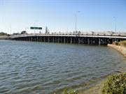
Canning Bridge northbound/downstream
MRWA No. 913
Melville
Metropolitan
Constructed from 1938
| Type | Status | Date | Documents |
|---|---|---|---|
| (no listings) |
| Type | Status | Date | Documents |
|---|---|---|---|
| (no listings) |
| Type | Status | Date | Grading/Management | |
|---|---|---|---|---|
| Category | ||||
| Art Deco Significant Bldg Survey | Completed | 30 Jun 1994 | ||
| Statewide Lge Timber Str Survey | Completed | 11 Dec 1998 | ||
16178 Canning Bridge
| Name | Type | Year From | Year To |
|---|---|---|---|
| E.W Godfrey, Public Works Department | Architect | - | - |
| Library Id | Title | Medium | Year Of Publication |
|---|---|---|---|
| 3174 | Western Roads : history of timber bridges in Western Australia. | Report | 1979 |
Historic site
| Epoch | General | Specific |
|---|---|---|
| Present Use | Transport\Communications | Road: Bridge |
| Original Use | Transport\Communications | Road: Bridge |
| Style |
|---|
| Other Style |
| General | Specific |
|---|---|
| TRANSPORT & COMMUNICATIONS | Road transport |
This information is provided voluntarily as a public service. The information provided is made available in good faith and is derived from sources believed to be reliable and accurate. However, the information is provided solely on the basis that readers will be responsible for making their own assessment of the matters discussed herein and are advised to verify all relevant representations, statements and information.
Canning Hwy Applecross and Como
Canning bridge westbound was assessed together with Canning Bridge eastbound, together as P16178 Canning Bridge. Is also part of P3926 Raffles Hotel Precinct.
Canning Bridge upstream
MRWA No. 912
South Perth
Metropolitan
Constructed from 1958
| Type | Status | Date | Documents |
|---|---|---|---|
| (no listings) |
| Type | Status | Date | Documents |
|---|---|---|---|
| (no listings) |
| Type | Status | Date | Grading/Management | |
|---|---|---|---|---|
| Category | ||||
| Statewide Lge Timber Str Survey | Completed | 11 Dec 1998 | ||
16178 Canning Bridge
| Library Id | Title | Medium | Year Of Publication |
|---|---|---|---|
| 6752 | South Perth : the vanishing village. | Book | 2003 |
Historic site
| Epoch | General | Specific |
|---|---|---|
| Original Use | Transport\Communications | Road: Bridge |
| Present Use | Transport\Communications | Road: Bridge |
| Type | General | Specific |
|---|---|---|
| Other | TIMBER | Other Timber |
| General | Specific |
|---|---|
| TRANSPORT & COMMUNICATIONS | Road transport |
This information is provided voluntarily as a public service. The information provided is made available in good faith and is derived from sources believed to be reliable and accurate. However, the information is provided solely on the basis that readers will be responsible for making their own assessment of the matters discussed herein and are advised to verify all relevant representations, statements and information.
Canning Hwy over the Canning River, between Applecross and Como Applecross and Como
Includes both bridges
Eastbound Downstream, ref 913
Westbound Upstream, ref 912
Melville
Metropolitan
Constructed from 1958, Constructed from 1937, Constructed from 1849 to 1869
| Type | Status | Date | Documents |
|---|---|---|---|
| Heritage List | Adopted | 16 Jun 2020 | |
| Heritage List | Adopted | 14 Nov 2000 | |
| State Register | Registered | 02 Mar 2012 | HCWebsite.Listing+ListingDocument, HCWebsite.Listing+ListingDocument |
| Type | Status | Date | Documents |
|---|---|---|---|
| (no listings) |
| Type | Status | Date | Grading/Management | |
|---|---|---|---|---|
| Category | ||||
| Municipal Inventory | Adopted | 17 Jun 2014 | Category A | |
Reports during the 1862 floods observed Canning Bridge being ‘gradually swept away’, with ‘only a portion of the centre remaining’ and the approaches completely lost.[1] However, less than three months later the bridge was reported as being ‘in a sufficient state of repair for all the purposes of ordinary traffic’.[2] In 1866, convicts were involved in repairs to both the bridge and its southern approaches.[3] Heritage documents in the 2000s claimed a replacement bridge was built by convicts in 1867, but searches of 1860s newspapers found no record of the bridge being replaced. Possibly works in 1869 to construct Upper Canning Bridge (Perth-Albany Road, Gosnells) have been confused with the Lower Canning site on the Perth-Fremantle Road.[4] Alternately, the ‘repairs’ of 1862 or 1866 may have been a complete reconstruction that was underreported. Canning Bridge was closed for some 18 months from early 1872 after a fire, rumoured to have been lit by fishermen, destroyed two central bays. The government offered £5 reward for information leading to conviction of those responsible. Winter floods caused further damage. The ‘reconstructed’ bridge reopened in 1873.[5] It is likely this ‘reconstruction’ was in later years remembered as a completely new bridge. The bridge that remained in 1892 (when a raised navigation span was added) was approximately 50ft longer than the one known to have been built in 1849,[6] supporting notions that it was not the original bridge (although, as the approaches were lost in the 1862 floods, it is possible that repairs included lengthening the bridge). As Fremantle Roads Board repeatedly invited tenders in 1872 and 1873 for the reconstruction work,[7] it is unlikely that convicts were involved. [1] Inquirer and Commercial News, 23 July 1862, p.4, https://trove.nla.gov.au/newspaper/article/69135805/6578395 [2] Perth Gazette and Independent Journal of Politics and News, 3 October 1862, p.3, https://trove.nla.gov.au/newspaper/article/2934069 [3] (no author), ‘Public Works’, Inquirer and Commercial News, 4 July 1866, p.3, https://trove.nla.gov.au/newspaper/article/69385749 [4] Perth Gazette and West Australian Times, 26 November 1869, p.2, https://trove.nla.gov.au/newspaper/article/3752009 (re Upper Canning Bridge under construction); Trove newspaper searches completed 5 & 6 November 2018 for ‘Canning Bridge’ and ‘tenders’ between 1862 and 1889; ‘Canning Bridge’ and ‘complete OR construct OR open’ between 1862 and 1869; ‘Canning Bridge’ (articles) in 1867; ‘Canning Bridge’ and ‘Public Works’ in 1868 (searching 163 WA newspapers) Report of recent and current public works in August 1867 mentions 40 bridges and does not include Canning Bridge (‘Public Works in the Colony’, Inquirer and Commercial News, 28 August 1867, p.2, https://trove.nla.gov.au/newspaper/article/69384127); Similar reports a year later 1868 also fail to mention any bridge on the Canning River or Perth-Fremantle Road Perth Gazette and West Australian Times, 14 August 1868, p.3, https://trove.nla.gov.au/newspaper/article/3753807) HCWA’s documentation for P16178 references the construction of a bridge in 1867 to a conference speech give in 2002 by Lloyd Margetts, engineer, of MRWA’s bridge section; South Perth Municipal Inventory place entry for the place (CB7) also references work by Margetts; Engineers Australia documents include direct input from Margetts, which is unreferenced (Engineers Australia WA Division Engineering Heritage Panel, Swan & Canning Rivers Bridges: Australian Engineering Week Tour 2012, Perth, July 2012, https://www.engineersaustralia.org.au/sites/default/files/content-files/2016-12/2012_heritage_bridges_tour_low_res.pdf [5] Kuon, ‘Percursory Papers’, Herald, 6 April 1872, p.3, https://trove.nla.gov.au/newspaper/article/111526212; ‘£5 Reward’ (advertisement), Herald, 25 May 1872, p.1, https://trove.nla.gov.au/newspaper/article/111527095; (no author), ‘Roads Boards: Fremantle’, Inquirer and Commercial News, 12 February 1873, p.4, https://trove.nla.gov.au/newspaper/article/65932858; Fremantle Roads Board, ‘Notice to the Public’, Inquirer and Commercial News, 23 July 1873, p.2, https://trove.nla.gov.au/newspaper/article/65933851 (quote ‘re-constructed’); Herald, 26 July 1873, p.3, https://trove.nla.gov.au/newspaper/article/114442667; [6] HCWA, P16178 Canning Bridge, Assessment Documentation, March 2012, p.5 [7] Eg Herald, 3 November 1872, p.2, https://trove.nla.gov.au/newspaper/article/114441332; (no author), ‘Roads Boards: Fremantle’, Inquirer and Commercial News, 4 December 1872, p.3, https://trove.nla.gov.au/newspaper/article/65933715
| Library Id | Title | Medium | Year Of Publication |
|---|---|---|---|
| 11995 | Report : Maintenance of Timber Bridges in the Metropolitian region. | Heritage Study {Other} | 2021 |
Historic site
| Epoch | General | Specific |
|---|---|---|
| Present Use | Transport\Communications | Road: Bridge |
| Original Use | Transport\Communications | Road: Bridge |
| Style |
|---|
| Other Style |
| Type | General | Specific |
|---|---|---|
| Other | METAL | Steel |
| Other | TIMBER | Other Timber |
| General | Specific |
|---|---|
| TRANSPORT & COMMUNICATIONS | Road transport |
This information is provided voluntarily as a public service. The information provided is made available in good faith and is derived from sources believed to be reliable and accurate. However, the information is provided solely on the basis that readers will be responsible for making their own assessment of the matters discussed herein and are advised to verify all relevant representations, statements and information.
Constructed from 1937, Constructed from 1999
Canning Bridge, comprising two almost identical timber bridges, Canning Bridge eastbound (1937) and Canning Bridge westbound (1958), over the Canning River between Applecross and Como, has cultural heritage significance for the following reasons: The place is rare as an intact, substantial timber bridge comprising two adjacent structures built at different times; the site represents changing transport systems in Perth since 1829, from its origins as a ferry crossing, construction of the original Canning Bridge (1849), its role as part of the first road link between the city of Perth and the port of Fremantle through to construction of the current structures; the fishing platform underneath the 1958 structure is one of the few remaining of its kind; the place is valued as a site of recreational activities in the past to the present day, including organised sporting events, and as a venue for informal recreational activities; it achieved prominence in 1962, as the end point for rowing at the VII British Empire and Commonwealth Games; the place is an important landmark when viewed from the Swan and Canning Rivers, and the river foreshores. It contributes to the cultural landscape of the Applecross commercial precinct which includes Raffles Hotel (1937) and the distinctive façade of Applecross District Hall (1934); the place is a good example of a large timber bridge with cross braced driven piles, and demonstrates evidence of the innovative techniques of bridge conservation developed by the Main Roads Department in the 1970s. The signage on the bridges and the metal railings in the centre of the bridge have little significance.
Canning Bridge comprises two timber and steel framed bridges crossing the Canning River at Canning Highway connecting Melville and South Perth.
In summer, the Beeliar Nyoongars used the Canning River as a hunting ground as there was an abundant supply of food for them, and they used the land area around the Canning Bridge as a campsite. Initially, the site of the Canning Bridge was solely a ferry crossing at the narrowest point between the later settlements of Applecross and Como, close to the junction of the Canning and Swan Rivers. The first bridge across the river opened in 1843 to the design of Superintendent of Public Works, Henry Trigg, and constructed by Solomon Cook. A second replacement bridge was constructed in 1849 to increase the clearance beneath the 1843 bridge. In 1867 a new bridge was constructed with convict labour to increase traffic flow and address flood damage. Again, in 1908 and 1937 new bridges were constructed to replace the forerunners. In 1958, a new bridge was constructed solely for westbound traffic and the earlier 1937 bridge designated for eastbound traffic, to overcome the inadequacy of two-way traffic on a single bridge. Subsequently, concrete road overlays were introduced to both bridges in 1976 and 1984, and major repairs and maintenance was applied in 1994-96 and 1998-99.
Sound
| Ref ID No | Ref Name | Ref Source | Ref Date |
|---|---|---|---|
| "State Register of Heritage Places Assessment documentation for Place No. 16178 'Canning Bridge'". | HCWA | 2012 |
| Owner | Category |
|---|---|
| Main Roads WA | State Gov't |
This information is provided voluntarily as a public service. The information provided is made available in good faith and is derived from sources believed to be reliable and accurate. However, the information is provided solely on the basis that readers will be responsible for making their own assessment of the matters discussed herein and are advised to verify all relevant representations, statements and information.
Constructed from 1849
Canning Bridge, comprising two almost identical timber bridges, Canning Bridge eastbound (1937) and Canning Bridge westbound (1958), over the Canning River between Applecross and Como, has cultural heritage significance for the following reasons: • the place is rare as an intact, substantial timber bridge comprising two adjacent structures built at different times; • the site represents changing transport systems in Perth since 1829, from its origins as a ferry crossing, construction of the original Canning Bridge (1849), its role as part of the first road link between the city of Perth and the port of Fremantle through to construction of the current structures; • the fishing platform underneath the 1958 structure is one of the few remaining of its kind; • the place is valued as a site of recreational activities in the past to the present day, including organised sporting events, and as a venue for informal recreational activities. It achieved prominence in 1962, as the end point for rowing at the VII British Empire and Commonwealth Games; • the place is an important landmark when viewed from the Swan and Canning Rivers, and the river foreshores. It contributes to the cultural landscape of the Applecross commercial precinct which includes Raffles Hotel (1937) and the distinctive façade of Applecross District Hall (1934); and, • the place is a good example of a large timber bridge with cross braced driven piles, and demonstrates evidence of the innovative techniques of bridge conservation developed by the Main Roads Department in the 1970s. The signage on the bridges and the metal railings in the centre of the bridge have little significance.
Canning Bridge spans Canning River at the narrowest point where the River flows into the Swan River in Como and Applecross. The bridge consists of two adjacent timber structures designed and built by the Main Roads Department of Western Australia. The first structure, completed 1937, was designed and supervised by E. W. Godfrey, Chief Transport Engineer for Main Roads, and the second, almost identical, structure was completed 1958. Canning Bridge eastbound (1937) has a total length of 465 foot (141.8m), an overall width of 51’ 7” (15.7m) and an average clearance above normal water level of 19’ 8” (6.0m). It consists of 22 spans, typically 20 foot (6.1m) apart except for the central navigational span, which is 40 foot (12.2m) wide. The bridge is supported on timber piles. The piles have been potted at various locations and the majority have been epoxy wrapped at water level. The deck consists of three traffic lanes 37’ 5” (11.4m) wide and a footpath. Canning Bridge westbound (1958) has an overall length of 474 foot (144.6m), a width of 45 foot (13.7m) and a clearance of 19’ 8” (6.0m) above normal water level. It consists of 22 spans, typically 20 foot (6.1m) apart except for the navigational span, which is 40 foot (12.2m). The bridge is supported on timber piles, typically eight per span except for the navigational span, which has 12 piles. The deck of the bridge consists of three traffic lanes 37’ 4” (11.4m) wide and a 4’ 11” (1.5m) wide footpath. The timber pylons on both bridges are inscribed with roman numerals. Both bridges are sealed in hot mix asphalt on the vehicular traffic lanes and the footpaths are timber decking overlaid with concrete. The bridges carry water and electrical services. Steel conduits for street lighting are located on the base of the guardrail on the right hand side of the footpath on the downstream (1937) bridge. A similar steel conduit is attached to the half caps adjacent to the left hand side of the footpath posts on the Canning Bridge westbound (1958). The building of the fishing platform on Canning Bridge westbound (1958) emulates the platform on the third Canning Bridge built in 1908, which was specifically designated for fishing. It is now designated as a maintenance platform reached by a timber gangplank that adjoins the shoreline under the bridge. The area around Canning Bridge has seen continual development since the 1960s. As a result Canning Bridge is an important landmark with arteries leading off north and south into the Kwinana Freeway, east and west to the Canning Highway and east to Manning Road. The construction of Canning Bridge station in December 2007 for the Perth to Mandurah rail line has further impacted and changed the surrounding environment. The area around the bridge exhibits a mixture of land uses including wetlands, urban infrastructure and recreation. On the Como side of Canning Bridge between the Kwinana Freeway and the river there are no built elements. The vegetation consists of grassed riverbanks and re-established areas of native flora including Salt sheoak (Casuarina obesa), Geraldton wax (Chamelacium uncinatumm) Pencil pines (Cupressus) and a number of wattle and banksia species.
The first bridge over the Canning River was designed by the Superintendent of Public Works, Henry Trigg, who advertised for building tenders in the Perth Gazette on 26 December 1846. The original tenders for the bridge were too high so the project did not advance. In 1849 tenders were recalled and the contract was awarded to Solomon Cook. Cook completed the bridge in four months at a cost of £425. The bridge was 520 feet (175 metres) long, 12 feet (4 metres) wide and had a deck eight feet (2 metres) above the water. The central span of the bridge was 24 feet (8 metres) wide to allow boats to pass underneath.1 The bridge was an important part of road communication between Guildford, Perth and Fremantle even though for a number of years the river remained the main method of transportation of goods between the inland reaches and the coastal port. In 1862 widespread flooding throughout the Swan and Canning Rivers led to massive damage to the Canning, Causeway and Helena (in Guildford) bridges. Owing to the damage, a second Canning Bridge was built in 1867 using convict labour. It is thought the site of the second Canning Bridge was very close to the present bridge. Canning Bridge No. 2 was built 12 feet (4 metres) above the water but was raised in 1892 to 18 feet (6 metres) to allow for increased navigational clearance. Maintenance of the Canning Bridge and the road that linked Perth to Fremantle was given a low priority in the late nineteenth and early twentieth centuries, leading to a deterioration of structure. According to one report from the time, a fire had caused bad damage and a replacement bridge was sought. Owing to the critical nature of the bridge, the State Government allocated funding for a new bridge in 1907-08. Canning Bridge No. 3 was constructed in 1908 and was located south east of the bridge that is currently used (2003). Flatter in appearance and stronger in construction, the new bridge was built under contract for the cost of £2,023. At this time a fishing platform was added to the bridge. Despite the stronger construction, the 1908 bridge was replaced by a new bridge which was commenced in 1937. Built by the Main Roads Department at a cost of £24,830 Canning Bridge No. 4 was constructed with a number of essential services such as water and gas mains and electricity installed under the roadway. The navigation openings included two of 24m wide and one of 18m wide. The bridge was constructed of karri, jarrah and wandoo owing to their abundance and resistance to fire and dry rot. To protect the timber piles from marine borers, concrete collars were put in place. Enhancing the appearance of the bridge were four ornamental concrete pylons surmounted with lanterns cast in bronze and placed at the entrances. Canning Bridge No.4 was officially opened on December 1939 by the Minister of Works, H. Millington MLA. The opening was celebrated by a small gathering of Main Roads people at the Swan Hotel. The old bridge which was going to be demolished had a reprieve owing to the outbreak of World War Two. Owing to the fear of invasion, the old bridge was kept in case of possible damage to the new bridge by an enemy attack. The old bridge was therefore not demolished until the late 1940s. Since then there have been various maintenance and renovation programs. In 1976 a reinforced concrete overlay was placed on the bridge deck and in 1994-5 termite damage led to karri timber being replaced by steel. In 1998-99 superstructure damage was arrested by reinforced concrete treatment. The Canning Bridge remains a vital link between South Perth and Fremantle.
High
Good
| Name | Type | Year From | Year To |
|---|---|---|---|
| Henry Trigg | Architect | - | - |
| Ref ID No | Ref Name | Ref Source | Ref Date |
|---|---|---|---|
| Edmonds, L. "The Vital Link: A History of Main Roads of WA 1926-1996" | UWA Press | 1997 | |
| Florey, C. "Peninsular City: A Social History of South Perth" | City of South Perth | 1995 | |
| Le Page, J.S.H. "Building a State: The Story of the Public Works Department WA 1829-1985" | |||
| Margetts, L. Article 'The Bridges of South Perth' | South Perth- The Vanishing Village (Published by South perth Historical Society) | 2002 |
| Reserve | Lot/Location | Plan/Diagram | Vol/Folio |
|---|---|---|---|
| 12508 | 219118 | 3119-153 |
This information is provided voluntarily as a public service. The information provided is made available in good faith and is derived from sources believed to be reliable and accurate. However, the information is provided solely on the basis that readers will be responsible for making their own assessment of the matters discussed herein and are advised to verify all relevant representations, statements and information.
201 Great Easterm Highway Burswood
Burswood Island Golf Course
Rivervale Tip
Belmont
Metropolitan
Constructed from 1909
| Type | Status | Date | Documents |
|---|---|---|---|
| (no listings) |
| Type | Status | Date | Documents |
|---|---|---|---|
| RHP - Does not warrant assessment | Current | 22 Feb 2019 |
| Type | Status | Date | Grading/Management | |
|---|---|---|---|---|
| Category | ||||
| (no listings) | ||||
• The place is associated with the development of Perth’s waste management, including the development of sewerage treatment and prior use as a rubbish dump.
• The place demonstrates the post-war redevelopment of the Swan River into recreation areas, including rehabilitation areas of previous industrial or waste management use.
The place is associated with the development of Perth’s waste management, including the development of sewerage treatment and prior use as a rubbish dump. The place demonstrates the post-war redevelopment of the Swan River into recreation areas, including rehabilitation areas of previous industrial or waste management use
Burswood Tip (fmr) is located on the Burswood Peninsula in the Town of Victoria Park within the metropolitan region, the area lying on the southwest portion of the peninsula south of the recently-developed stadium. The current use and layout of the place is a recreational park. Recent landscaping associated with the development of Optus Stadium includes the planting of new trees and lawns, the establishment of roads and pathways, as well as the addition of nearby parking areas. The area’s history as a former rubbish tip and sewerage treatment area is not visible in the current landscape.
The Burswood peninsula took its name from the family estate of English settler Henry Camfield, who arrived in Western Australia on 12 October 1829. Camfield was disappointed with his original land grants in the colony but succeeded in getting Surveyor General J. S. Roe to grant him 1,000 acres which included the peninsula, previously reserved for Crown purposes. The area was eventually taken up with large land grants, and the addition of transported convict labour after 1850 provided for the development of roads and bridges in the area. By the 1880s, there approximately 100 houses in the area. A slowly developing economy saw the subdivision and sale of the larger land grants for residential purposes, one of the earliest being the “Victoria Park Estate” in 1887. The discovery of gold in the 1890s saw a flood of new settlers and by the turn of the century more of the original farms were being converted into residential and commercial areas. This process of urbanisation accelerated in the inter-war period, as well as seeing industrial enterprises such as the Portland Cement Works take up position on the previously unutilised riverside areas. While sewerage treatment plants had been located at Burswood island c.1909, the swampy area was considered a health hazard due to the mosquitos that bred there. The noxious smells and river pollution from the sewerage filtration beds remained a bone of public contention throughout this period. Part of the process of the sewerage treatment during this time was the removal of rubbish from the filtration beds, which was buried in the foreshore of the river. The situation was finally resolved by 1936 when the Metropolitan Sewerage Service was established to replace the aging Burswood plant. The area appears to have still been used as an illegal rubbish dump at this point. Burswood Tip (also known as the Rivervale Tip for a time) operated from 1946 until 1985. It initially recieved fly ash from the East Perth Power Station on the other side of the river, but after 1954 also recieved local rubbish from the surrounding area. It closed for several years in 1972 but was reopened briefly for general waste in 1978. From 1979 it was only used for the recieving, chipping and storing garden waste and tree prunings before they were taken elsewhere. It was close din 1985 and the land was developed for the Burswood Island Gold Course.
Urban Open Space
| General | Specific |
|---|---|
| DEMOGRAPHIC SETTLEMENT & MOBILITY | Environmental change |
| DEMOGRAPHIC SETTLEMENT & MOBILITY | Technology & technological change |
| SOCIAL & CIVIC ACTIVITIES | Environmental awareness |
| SOCIAL & CIVIC ACTIVITIES | Sport, recreation & entertainment |
| SOCIAL & CIVIC ACTIVITIES | Community services & utilities |
This information is provided voluntarily as a public service. The information provided is made available in good faith and is derived from sources believed to be reliable and accurate. However, the information is provided solely on the basis that readers will be responsible for making their own assessment of the matters discussed herein and are advised to verify all relevant representations, statements and information.
Claisbrook
Identified in Oline Richard's work on historic public gardens in Perth, WA.
Victoria Gardens
Perth
Metropolitan
Constructed from 1876
| Type | Status | Date | Documents |
|---|---|---|---|
| (no listings) |
| Type | Status | Date | Documents |
|---|---|---|---|
| (no listings) |
| Type | Status | Date | Grading/Management | |
|---|---|---|---|---|
| Category | ||||
| (no listings) | ||||
Some mature trees remain around the periphery but most of the park is now grassed. A modern representation of a band-stand covers seating. Trafalger Bridge crosses Claisebrook Cove to more parkland on the opposite side which was also part of the original Victoria Park.
| Library Id | Title | Medium | Year Of Publication |
|---|---|---|---|
| 7814 | A fairer Athens and a freer Rome: historic public gardens in Perth, WA. | Journal article | 1982 |
Landscape
| Epoch | General | Specific |
|---|---|---|
| Original Use | SOCIAL\RECREATIONAL | Other |
| Present Use | SOCIAL\RECREATIONAL | Other |
| Original Use | SOCIAL\RECREATIONAL | Rotunda or Bandstand |
| General | Specific |
|---|---|
| SOCIAL & CIVIC ACTIVITIES | Sport, recreation & entertainment |
This information is provided voluntarily as a public service. The information provided is made available in good faith and is derived from sources believed to be reliable and accurate. However, the information is provided solely on the basis that readers will be responsible for making their own assessment of the matters discussed herein and are advised to verify all relevant representations, statements and information.
109 Bessell Av Como
South Perth
Metropolitan
Constructed from 1952
| Type | Status | Date | Documents |
|---|---|---|---|
| (no listings) |
| Type | Status | Date | Documents |
|---|---|---|---|
| RHP - Does not warrant assessment | Current | 25 Nov 2011 |
| Type | Status | Date | Grading/Management | |
|---|---|---|---|---|
| Category | ||||
| (no listings) | ||||
Individual Building or Group
| Epoch | General | Specific |
|---|---|---|
| Present Use | VACANT\UNUSED | Vacant\Unused |
| Original Use | RESIDENTIAL | Single storey residence |
| Type | General | Specific |
|---|---|---|
| Roof | TILE | Cement Tile |
| Wall | BRICK | Common Brick |
This information is provided voluntarily as a public service. The information provided is made available in good faith and is derived from sources believed to be reliable and accurate. However, the information is provided solely on the basis that readers will be responsible for making their own assessment of the matters discussed herein and are advised to verify all relevant representations, statements and information.
111 Bessell Av Como
South Perth
Metropolitan
| Type | Status | Date | Documents |
|---|---|---|---|
| (no listings) |
| Type | Status | Date | Documents |
|---|---|---|---|
| RHP - Does not warrant assessment | Current | 27 Oct 2017 |
| Type | Status | Date | Grading/Management | |
|---|---|---|---|---|
| Category | ||||
| (no listings) | ||||
The property is approx 1011sqms and is a 2 bedroom single detached house with sleep out and living area.
| Name | Type | Year From | Year To |
|---|---|---|---|
| State Housing Commission | Architect | - | - |
Individual Building or Group
| Epoch | General | Specific |
|---|---|---|
| Original Use | RESIDENTIAL | Single storey residence |
| Present Use | VACANT\UNUSED | Vacant\Unused |
This information is provided voluntarily as a public service. The information provided is made available in good faith and is derived from sources believed to be reliable and accurate. However, the information is provided solely on the basis that readers will be responsible for making their own assessment of the matters discussed herein and are advised to verify all relevant representations, statements and information.
112 Bessell Ave Como
South Perth
Metropolitan
Constructed from 1949
| Type | Status | Date | Documents |
|---|---|---|---|
| (no listings) |
| Type | Status | Date | Documents |
|---|---|---|---|
| RHP - Does not warrant assessment | Current | 25 Jul 2014 |
| Type | Status | Date | Grading/Management | |
|---|---|---|---|---|
| Category | ||||
| (no listings) | ||||
| Name | Type | Year From | Year To |
|---|---|---|---|
| State Housing Commission | Architect | 1949 | - |
Individual Building or Group
| Epoch | General | Specific |
|---|---|---|
| Original Use | RESIDENTIAL | Single storey residence |
| Present Use | VACANT\UNUSED | Vacant\Unused |
| Type | General | Specific |
|---|---|---|
| Wall | BRICK | Common Brick |
This information is provided voluntarily as a public service. The information provided is made available in good faith and is derived from sources believed to be reliable and accurate. However, the information is provided solely on the basis that readers will be responsible for making their own assessment of the matters discussed herein and are advised to verify all relevant representations, statements and information.
80 & 82 Birdwood Ave Como
South Perth
Metropolitan
Constructed from 1948
| Type | Status | Date | Documents |
|---|---|---|---|
| (no listings) |
| Type | Status | Date | Documents |
|---|---|---|---|
| RHP - Does not warrant assessment | Current | 27 Jun 2014 |
| Type | Status | Date | Grading/Management | |
|---|---|---|---|---|
| Category | ||||
| (no listings) | ||||
Individual Building or Group
| Epoch | General | Specific |
|---|---|---|
| Original Use | RESIDENTIAL | Conjoined residence |
| Present Use | VACANT\UNUSED | Vacant\Unused |
| Type | General | Specific |
|---|---|---|
| Wall | BRICK | Common Brick |
| Roof | TILE | Terracotta Tile |
This information is provided voluntarily as a public service. The information provided is made available in good faith and is derived from sources believed to be reliable and accurate. However, the information is provided solely on the basis that readers will be responsible for making their own assessment of the matters discussed herein and are advised to verify all relevant representations, statements and information.
Bruce St Como
South Perth
Metropolitan
Constructed from 1968
| Type | Status | Date | Documents |
|---|---|---|---|
| (no listings) |
| Type | Status | Date | Documents |
|---|---|---|---|
| RHP - Does not warrant assessment | Current | 14 Dec 2012 |
| Type | Status | Date | Grading/Management | |
|---|---|---|---|---|
| Category | ||||
| (no listings) | ||||
| Name | Type | Year From | Year To |
|---|---|---|---|
| Public Works Department | Architect | - | - |
Individual Building or Group
| Epoch | General | Specific |
|---|---|---|
| Present Use | EDUCATIONAL | Secondary School |
| Original Use | EDUCATIONAL | Secondary School |
| Style |
|---|
| Post-War Perth Regional |
| Type | General | Specific |
|---|---|---|
| Other | METAL | Aluminium |
| Other | GLASS | Glass |
| Roof | TILE | Terracotta Tile |
| Other | CONCRETE | Concrete Slab |
| Other | CONCRETE | Concrete Block |
| General | Specific |
|---|---|
| SOCIAL & CIVIC ACTIVITIES | Education & science |
This information is provided voluntarily as a public service. The information provided is made available in good faith and is derived from sources believed to be reliable and accurate. However, the information is provided solely on the basis that readers will be responsible for making their own assessment of the matters discussed herein and are advised to verify all relevant representations, statements and information.
58 Cale Rd Como
South Perth
Metropolitan
Constructed from 1953 to 1962
| Type | Status | Date | Documents |
|---|---|---|---|
| (no listings) |
| Type | Status | Date | Documents |
|---|---|---|---|
| (no listings) |
| Type | Status | Date | Grading/Management | |
|---|---|---|---|---|
| Category | ||||
| Anglican Church Inventory | YES | 31 Jul 1996 | ||
Individual Building or Group
| Epoch | General | Specific |
|---|---|---|
| Original Use | RELIGIOUS | Church, Cathedral or Chapel |
| Original Use | RELIGIOUS | Church Hall |
| Present Use | RELIGIOUS | Church, Cathedral or Chapel |
| Type | General | Specific |
|---|---|---|
| Roof | ASBESTOS | Fibrous Cement, corrugated |
| Wall | BRICK | Common Brick |
| General | Specific |
|---|---|
| SOCIAL & CIVIC ACTIVITIES | Religion |
This information is provided voluntarily as a public service. The information provided is made available in good faith and is derived from sources believed to be reliable and accurate. However, the information is provided solely on the basis that readers will be responsible for making their own assessment of the matters discussed herein and are advised to verify all relevant representations, statements and information.
182 Canning Hwy Como
Electricity Substation
South Perth
Metropolitan
| Type | Status | Date | Documents |
|---|---|---|---|
| Heritage List | Adopted | 25 Sep 2018 |
| Type | Status | Date | Documents |
|---|---|---|---|
| RHP - Does not warrant assessment | Current | 23 Feb 2007 |
| Type | Status | Date | Grading/Management | |
|---|---|---|---|---|
| Category | ||||
| (no listings) | ||||
| Library Id | Title | Medium | Year Of Publication |
|---|---|---|---|
| 9716 | Electricity generation, transmission and distribution in Western Australia: representation on the register of heritage places. | Brochure | 2007 |
Individual Building or Group
| Epoch | General | Specific |
|---|---|---|
| Present Use | RESIDENTIAL | Two storey residence |
| Other Use | RESIDENTIAL | Flats\Apartment Block |
| Original Use | GOVERNMENTAL | Power Station |
| Style |
|---|
| Late 20th-Century Imgnts Nostalgic |
| Type | General | Specific |
|---|---|---|
| Roof | CONCRETE | Concrete Slab |
| Wall | BRICK | Rendered Brick |
| Other | CONCRETE | Concrete Slab |
This information is provided voluntarily as a public service. The information provided is made available in good faith and is derived from sources believed to be reliable and accurate. However, the information is provided solely on the basis that readers will be responsible for making their own assessment of the matters discussed herein and are advised to verify all relevant representations, statements and information.
Constructed from 1922, Constructed from 1963 to 1964
• The place has aesthetic value as a rare and unusual example of a conversion of an industrial building to a residence with many decorative elements reflecting the Italian origins of the owners. Internal details that remain from the original construction may demonstrate the original function of the place. • The place has aesthetic and social value as a landmark on Canning Highway since the early 1960s. • The place has historic value for its association with the first automatic tramway substation in Perth built in 1922.
Two storey house located in an open position on the corner of Hensman Street and Canning Highway adding to its prominence in the streetscape. The height of the house is further increased due to the steel balustrade running around the top of the elevations and a centrally located third storey room in the middle of the roof. Rendered light columns are also positioned on the street facing corners of the roof. The house is of simple presentation with timber framed openings positioned all around the house. Some of the upper level rooms open directly onto the balcony which extends all the way around the front and side elevations. The balcony has the same metal balustrade as the roof. An external stair connects all levels of the building at the rear. The garden is enclosed by a low concrete wall with pre-cast concrete balustrade which obscured much of the ground level from clear view. The architectural style is designated as being in the Late Twentieth Century Immigrant’s Nostalgic style.
This building was constructed in 1922 to serve as an electricity sub station for the new South Perth tram route along Fremantle Road (now Canning Highway) which commenced operation in August 1922. In 1922, a local news report described the sub station as a 'Wonder House' because of its 'wonderful mechanism operated by unseen forces'. This automatic traction sub station was the first in Western Australia and operated in response to a series of relays and switches. One of the advantages of the system was the reduction of wages as employees were not needed to be stationed at the premises full time. The South Perth route operated until 1950 and the property was subsequently sold into private ownership. From the available information the place was transferred to Umberto Cippitelli (c1928-1992) who arrived in Western Australia in 1952 from Italy. He worked as a firewood cutter in Lakewood before settling in Perth. He was joined by his wife Rosa in 1955. In 1963, an application was lodged with the Shire of South Perth by Cippitelli to convert the property to three flats. The conversion included constructing a tiled pitched roof and inserting a floor into the building to create two floors. The pitched roof did not eventuate and the flat roof was subsequently utilised as a sun room with new balconies on the roof edge. The name 'Roma' originates from this time and the conversion by the Cippitelli family. Umberto Cippitelli was a part owner of the Belmont Concrete Company and his involvement in that trade is likely to have influenced the choice of materials in the conversion and the decorative details, in addition to the ornamental elements in the garden. The place was later converted to a single residence for the Cippitelli family and continues to be used as a single residence (2018).
Low / Moderate
Good
| Ref ID No | Ref Name | Ref Source | Ref Date |
|---|---|---|---|
| The West Australian | 25 July 1921 | ||
| Government Gazette | 3 February 1956 | ||
| City of South Perth Local Heritage Inventory 2015 | |||
| The Daily News | 6 December 1922 |
| Reserve | Lot/Location | Plan/Diagram | Vol/Folio |
|---|---|---|---|
| 7570 | 5533 | 1252-597 |
| Owner | Category |
|---|---|
| Cipitelli & Fagnani | Other Private |
This information is provided voluntarily as a public service. The information provided is made available in good faith and is derived from sources believed to be reliable and accurate. However, the information is provided solely on the basis that readers will be responsible for making their own assessment of the matters discussed herein and are advised to verify all relevant representations, statements and information.
299 Canning Hwy Como
South Perth
Metropolitan
Constructed from 1953
| Type | Status | Date | Documents |
|---|---|---|---|
| (no listings) |
| Type | Status | Date | Documents |
|---|---|---|---|
| (no listings) |
| Type | Status | Date | Grading/Management | |
|---|---|---|---|---|
| Category | ||||
| (no listings) | ||||
Individual Building or Group
| Epoch | General | Specific |
|---|---|---|
| Original Use | Transport\Communications | Comms: Post or Telegraph Office |
| Type | General | Specific |
|---|---|---|
| Roof | METAL | Corrugated Iron |
| Wall | METAL | Corrugated Iron |
This information is provided voluntarily as a public service. The information provided is made available in good faith and is derived from sources believed to be reliable and accurate. However, the information is provided solely on the basis that readers will be responsible for making their own assessment of the matters discussed herein and are advised to verify all relevant representations, statements and information.
353 Canning Hwy Como
South Perth
Metropolitan
Constructed from 1935
| Type | Status | Date | Documents |
|---|---|---|---|
| (no listings) |
| Type | Status | Date | Documents |
|---|---|---|---|
| RHP - Does not warrant assessment | Current | 30 Nov 2012 |
| Type | Status | Date | Grading/Management | |
|---|---|---|---|---|
| Category | ||||
| (no listings) | ||||
Fair
Individual Building or Group
| Epoch | General | Specific |
|---|---|---|
| Present Use | RESIDENTIAL | Single storey residence |
| Original Use | RESIDENTIAL | Single storey residence |
| Type | General | Specific |
|---|---|---|
| Roof | TILE | Terracotta Tile |
| Wall | BRICK | Common Brick |
This information is provided voluntarily as a public service. The information provided is made available in good faith and is derived from sources believed to be reliable and accurate. However, the information is provided solely on the basis that readers will be responsible for making their own assessment of the matters discussed herein and are advised to verify all relevant representations, statements and information.
376 Canning Hwy Como
South Perth
Metropolitan
Constructed from 1950
| Type | Status | Date | Documents |
|---|---|---|---|
| (no listings) |
| Type | Status | Date | Documents |
|---|---|---|---|
| RHP - Does not warrant assessment | Current | 29 Jun 2018 |
| Type | Status | Date | Grading/Management | |
|---|---|---|---|---|
| Category | ||||
| (no listings) | ||||
• The place is a good representative example of a brick and tile residence constructed post-WWII; and,
• The place demonstrates the expansion of the South Perth area during the post-WWII period.
• The place is a good representative example of a brick and tile residence constructed post-WWII; and, • The place demonstrates the expansion of the South Perth area during the post-WWII period.
P25998 House, 376 Canning Highway, Como, comprising a single storey brick and tile residence, is situated on an allotment fronting Canning Highway in Como. The residence comprises a brick and tile building, with stretcher bond red brick and render to widow height. The front includes a central entrance, including verandah, flanked by timber framed windows. An enclosed verandah is situated to the rear and a metal framed and clad carport structure to the east. The front entry opens to a hallway that connects the front bedroom and living rooms. The hallway extends further and connects the bathroom, rear kitchen and bedroom. The kitchen is adjacent to the rear dining room and opens to the rear enclosed verandah, which is also associated with the laundry and toilet. The interior flooring comprises tiling in wet areas, linoleum in the kitchen, carpets in the bedrooms and living area, and painted concrete on the front and rear verandahs. There are art deco ceiling details in the entry hallway and living room and a face brick fireplace also in the living room.
In the early twentieth century, the allotment comprising the place was part of a larger 88 acre portion of land, known as Swan Location 41, owned by Robert Alston. Throughout the 1920s, Robert Alston subdivided the land. In 1930, Norman Williams, Farmer, purchased Lot 386 and Lot 387. Lot 386 (No. 376 Canning Hwy) was then transferred to several people throughout the next two decades, but remained undeveloped. Following the limited growth in the State during the war and Depression years, the post-war period brought with it a population boom associated with the Soldier Settlement Scheme. The South Perth area, including Como, benefited from construction programs connected with the War Service Homes and State Housing Commission schemes. P25998 House, 376 Canning Highway, Como was built privately and was not associated with these schemes. In 1940, Lot 386 was transferred to Bernard Franklin. The Post Office Directory for 1949 shows that H. Martin was living at No. 376 Canning Highway. Aerial imagery for 1953 shows the current residence. No other major exterior additions or changes appear to have occurred after this. In c.1970, the bathroom was renovated and a front verandah awning was installed. The place is currently (2018) vacant and is marked for demolition in preparation for widening of Canning Highway.
Individual Building or Group
| Epoch | General | Specific |
|---|---|---|
| Original Use | RESIDENTIAL | Single storey residence |
| Style |
|---|
| Vernacular |
| Type | General | Specific |
|---|---|---|
| Roof | CONCRETE | Other Concrete |
| Wall | BRICK | Common Brick |
| Wall | BRICK | Rendered Brick |
| Roof | TILE | Cement Tile |
This information is provided voluntarily as a public service. The information provided is made available in good faith and is derived from sources believed to be reliable and accurate. However, the information is provided solely on the basis that readers will be responsible for making their own assessment of the matters discussed herein and are advised to verify all relevant representations, statements and information.
390 Canning Hwy Como
South Perth
Metropolitan
Constructed from 1955
| Type | Status | Date | Documents |
|---|---|---|---|
| (no listings) |
| Type | Status | Date | Documents |
|---|---|---|---|
| RHP - Does not warrant assessment | Current | 29 Jun 2018 |
| Type | Status | Date | Grading/Management | |
|---|---|---|---|---|
| Category | ||||
| (no listings) | ||||
• The place is a good representative example of a brick and tile residence constructed post-WWII; and,
• The place demonstrates the expansion of the South Perth area during the post-WWII period.
House, 390 Canning Highway, Como is a good representative example of a brick and tile residence constructed post-WWII and demonstrates the expansion of the South Perth area during the post-WWII period.
P25999 House, 390 Canning Highway, Como comprising a single storey brick and tile residence and rear brick carport/shed, is situated on an allotment fronting Canning Highway in the Como area. The place is flanked by 1970s apartment complexes. A brick and tile carport/shed building is located to the rear, adjacent to the pedestrian walkway. The residence comprises a red stretcher bond brick and red tile building on a limestone foundation. The front includes a central front entrance, including a painted concrete step, flanked by timber framed windows and a small verandah on the western side, of concrete floor and painted steep balustrading. The rear elevation includes a patio addition that has been enclosed with aluminium framing and sheeting. The interior comprises the living room, including brick fireplace, and front bedroom leading from the front entry foyer. The entry foyer connects to the central hallway, which leads to all three bedrooms, bathroom, and kitchen. The kitchen leads to the front dining room, which opens to the verandah on the western side, laundry and rear foyer. The rear foyer and two rear bedrooms open to the enclosed patio addition. Interior detailing includes timber flooring throughout bedrooms, living areas, and hallways, wall and floor tiles throughout wet areas, and tiles in the kitchen. Decorative cornice, typical of the period, is locate throughout all main living areas.
In the early twentieth century, the allotment comprising the place was part of a larger 88 acre portion of land, known as Swan Location 41, owned by Robert Alston. Throughout the 1920s, Robert Alston subdivided the land. In 1929, Thomas Ede, Accountant, purchased the land (Lot 420) comprising the place. Lot 420 was then transferred to several people throughout the next two decades, but remained undeveloped. Searches of the post office directory also suggested that no one was living at the property prior to House, 390 Canning Highway, Como. Following the limited growth in the State during the war and Depression years, the post-war period brought with it a population boom associated with the Soldier Settlement Scheme. The South Perth area, including Como, benefited from construction programs connected with the War Service Homes and State Housing Commission schemes. P25999 House, 390 Canning Highway, Como was built privately and was not associated with these schemes. Between 1953 and 1965, aerial imagery shows that the current house had been built, which also included a rear access brick and tile building. Given surrounding development of the area, the current building was probably erected by 1955. Despite much of the residential development for this period in the area being associated with the State Housing Commission schemes of accessible housing, no evidence suggested that House, 390 Canning Highway, Como was erected as a result of these schemes. However, the place is likely to be a representative example of the type of housing erected during the period. In c.1970, the rear porch was enclosed with aluminium framing. In c.1990, the kitchen was upgraded, but the original stove alcove remains. By c.2001, aerial imagery shows that most of the brick and tile building to the rear of the place had been demolished. A small brick and tile carport/shed still remains. No other major modifications have been completed to the exterior. The place is currently (2018) vacant and is marked for demolition in preparation for widening of Canning Highway.
Individual Building or Group
| Epoch | General | Specific |
|---|---|---|
| Original Use | RESIDENTIAL | Single storey residence |
| Style |
|---|
| Vernacular |
| Type | General | Specific |
|---|---|---|
| Roof | TILE | Other Tile |
| Wall | BRICK | Common Brick |
This information is provided voluntarily as a public service. The information provided is made available in good faith and is derived from sources believed to be reliable and accurate. However, the information is provided solely on the basis that readers will be responsible for making their own assessment of the matters discussed herein and are advised to verify all relevant representations, statements and information.
426 Canning Hwy Como
South Perth
Metropolitan
Constructed from 1956
| Type | Status | Date | Documents |
|---|---|---|---|
| Heritage List | Adopted | 14 Nov 2000 |
| Type | Status | Date | Documents |
|---|---|---|---|
| (no listings) |
| Type | Status | Date | Grading/Management | |
|---|---|---|---|---|
| Category | ||||
| (no listings) | ||||
Individual Building or Group
| Epoch | General | Specific |
|---|---|---|
| Original Use | RESIDENTIAL | Two storey residence |
| Present Use | RESIDENTIAL | Two storey residence |
| Style |
|---|
| Inter-War Functionalist |
| General | Specific |
|---|---|
| DEMOGRAPHIC SETTLEMENT & MOBILITY | Settlements |
This information is provided voluntarily as a public service. The information provided is made available in good faith and is derived from sources believed to be reliable and accurate. However, the information is provided solely on the basis that readers will be responsible for making their own assessment of the matters discussed herein and are advised to verify all relevant representations, statements and information.
Constructed from 1952 to 1953
• The place has aesthetic value as an intact and rare late example of a two story brick residence in the Inter War Functionalist style. Internal details that remain from the original construction are likely to reflect this style. • The place has aesthetic value as a landmark on this raised site on Canning Highway since the early 1950s. • The place has historic value for its association with the exuberant period following World War Two when new ideas in design were embraced. • The place has historic value for its association with prominent citizens Keith and Mabel Perron who were well known in business and social circles in Perth. • The place has social value as a demonstration of the type of home built for wealthy members of the community and their families in the Post World War Two period.
426 Canning Highway - ‘Blue Waters’ is situated on Canning Highway set back some distance from the road in a slightly elevated position demonstrating elements of the Art Deco style incorporating simple geometric shapes and asymmetrical massing. The house is of two storey construction with a dominant curved two storey bay incorporating continuous curved windows across the full extent of the curve. The main portion of the house is of single storey construction with a single garage under the house. An extensive balcony leading off from the curved upper storey provides views of the river.
This residence was constructed in 1952/3 for prominent local businessman Lionel Keith Perron (1918-1997) and his wife Mabel Ruth Perron, (1921-2013) nee McLean who married in 1951. The couple were inspired by a magazine illustration of a Florida Art Deco house design. It is understood that a local designer was engaged to prepare the designs however the architect or designer of the place have not been conclusively determined. Previous research has identified Designers R.M. Neal and Allan as the designers of the place but this has not been confirmed. Advertising in the local press during this period records R.M. Neal as a house designer homes in Perth. Work towards construction of the 1930s design was delayed, owing to the shortage of building materials during and after the War. The house plans were approved by South Perth Council in 1951, but construction did not occur until a year or two later. Due to the design of ‘Blue Waters’ involving a greater quantity of bricks and glass than the ration system permitted, Keith Perron decided to establish a brickworks from which to source the required quantity of bricks. The curved glass windows and frames could not be manufactured locally and were shipped from the U.K. On completion the house featured in the local press where it was stated the name 'Blue Waters' was taken from the view. A brief description of the house was as follows; Pale pastel-blue walls and deep blue curtains tone with the rive scene. Upstairs, immediately over the drawing room, the centre of interest is a huge rumpus-room which opens out on to loggias. But the room to linger in is the bathroom. It is in rose pink with contrasting black, glossy tiles and "postage-stamp" beige tiles on the floor. The pink appointments were ordered in the Eastern States and imported from abroad. In May 1956, Council approval was given for the erection of a garage adjoining the rear of the house, abutting the southern boundary of the site. Access to this garage would have been via the rear right-of-way, Daisy Lane. This building was later converted into a games room. In 1961, the property was transferred to the first of a series of new owners who undertook alterations and additions to the interior of the place. In 2006, the property was transferred to a new owner who restored the place to its original finishes. Since its construction the place has been noted as a social hub and landmark. Particular during its period of ownership by the Perrons there were many parties and events held on the premises
High / High
Good
| Ref ID No | Ref Name | Ref Source | Ref Date |
|---|---|---|---|
| Apperly, R. Irving, R. Reynolds, P. "A Pictorial Guide to Identifying Australian Architecture" | Angus and Robertson NSW | 1989 | |
| Molyneux, I. "Looking Around Perth: A Guide to the Architecture of Perth & Surrounding Towns" | Royal Institute of Architects | 1981 |
| Reserve | Lot/Location | Plan/Diagram | Vol/Folio |
|---|---|---|---|
| 206 | 4156 | 1347-674 |
| Owner | Category |
|---|---|
| Norvilas | Other Private |
This information is provided voluntarily as a public service. The information provided is made available in good faith and is derived from sources believed to be reliable and accurate. However, the information is provided solely on the basis that readers will be responsible for making their own assessment of the matters discussed herein and are advised to verify all relevant representations, statements and information.
Cnr Canning Hwy & South Tce Como
South Perth
Metropolitan
Constructed from 1939
| Type | Status | Date | Documents |
|---|---|---|---|
| (no listings) |
| Type | Status | Date | Documents |
|---|---|---|---|
| (no listings) |
| Type | Status | Date | Grading/Management | |
|---|---|---|---|---|
| Category | ||||
| Classified by the National Trust | Classified | 11 Jun 2001 | ||
| Statewide Hotel Survey | Completed | 01 Nov 1997 | ||
| Local Heritage Survey | Adopted | 14 Nov 2000 | Category C | |
Individual Building or Group
| Epoch | General | Specific |
|---|---|---|
| Present Use | COMMERCIAL | Hotel, Tavern or Inn |
| Original Use | COMMERCIAL | Hotel, Tavern or Inn |
| Style |
|---|
| Inter-War Functionalist |
| Type | General | Specific |
|---|---|---|
| Roof | TILE | Ceramic Tile |
| Wall | BRICK | Painted Brick |
| General | Specific |
|---|---|
| OCCUPATIONS | Hospitality industry & tourism |
This information is provided voluntarily as a public service. The information provided is made available in good faith and is derived from sources believed to be reliable and accurate. However, the information is provided solely on the basis that readers will be responsible for making their own assessment of the matters discussed herein and are advised to verify all relevant representations, statements and information.
Constructed from 1939
• The place has aesthetic value for its remaining form and detail of the Inter War Functionalist style which is most evident in the main facades to Canning Highway and South Street. • The place has aesthetic value as a landmark in the streetscape for its prominent elevated position on a busy traffic junction. • The place has historic value for its association with the residential development of this area of South Perth in the 1930s. • The place has social value for the many members of the community who have attended the hotel for social events since 1939.
The Como Hotel is a two storey building of the Inter-War Functionalist (Austerity Moderne) design. The hotel is situated at the top of the highest point in the area and addresses the major intersection of South Terrace with Canning Highway. The prominent rectangular painted brick façade equally addresses both Canning Highway and South Terrace, provides a strong entry statement. The entry feature incorporates double height, octagonal Art Deco columns with chevron and scroll motifs supporting a concrete canopy and balcony balustrade. The entrance doors are set deep in the façade underneath the balcony. A tall parapet wall above the entrance/balcony adds further vertical emphasis to the entrance. The formerly cream brick building has been painted and is now grey/blue with cream accents. The public rooms and upper floor former bedrooms (no longer used) form symmetrical wings on either side of the entrance, with a continuous balcony running the length of each wing. A concrete balustrade in contrasting cream colour links the whole with a strong horizontal emphasis, typical of early ‘modern’ architecture. The hipped roof is of Marseilles pattern clay tiles and is pierced by several large simple brick chimneys. The windows at the lower level are placed with a regular rhythm adding a formality to the building. Some of the window openings have been replaced with metal framed openings and additional door openings have also been added.
In the early part of the twentieth century, largely due to their riverside location, Como and South Perth proved very popular with picnickers and holiday makers. By the late 1930s, these suburbs were rapidly developing as a popular choice of residence. The increasing importance of the Fremantle-Canning Road (now Canning Highway) as a major thoroughfare, made it a logical choice for new developments. Two new hotels were built in this period to serve the growing population of residents and visitors - the Hurlingham Hotel (1930-2004) and the Como Hotel (1939). The Como Hotel was built in 1939 for the owner Albert Edgar Dolin (c1890-1977). The design of the hotel was prepared by architects Oldham Boas Ednie-Brown and constructed by E. Allwood and Sons for £20,000. At the completion of the hotel it was celebrated as one of the most modern and well appointed hotels in Perth which made full use of the large corner block with commanding views to the city and river. Notable features of the hotel were the use of reinforced concrete in the upper floor and advanced use of structural steelwork. The extensive use of modern furniture, furnishings and lighting was considered part of this realisation of the utmost modernity. The original furniture scheme made extensive use of wall-to-wall Imperial Axminster carpeting in tone on toning - green in all major areas and fawn in the writing room. Polished jarrah furniture with thirty soft, restful lounge chairs upholstered in green to suit the general colour scheme, and numerous leather armchairs were part of the furniture. Contractors involved in the construction and fitting of the Como Hotel include E Allwood (builder), G Jenkinson Ltd (steelwork), G Smith and Son (painting), Heran Bros. and Stead (furniture) and Kelly and Rodoreda (fine dining supplies). In 1965, a bottle shop was added to the site which was a common trend in Perth hotels of the period. Ownership of the property transferred from the Dolin family in c1982 when it was acquired by local businessman Stan Perron and his business partner, Lyn Ryan who retained it until 2007. The hotel has undergone several programs of refurbishment and additions, including in 2014 when the bottle shop was demolished and a larger liquor store built on the site, and again in 2020 where the bottle shop was again demolished and replaced with an even larger liquor store. Significant alterations were also made to the Como Hotel in 2020 including to the rear courtyard, back-of-house facilities and the external facade.
High / Moderate
Good
| Name | Type | Year From | Year To |
|---|---|---|---|
| Oldham Boas & Ednie Browne | Architect | - | - |
| Reserve | Lot/Location | Plan/Diagram | Vol/Folio |
|---|---|---|---|
| 253 | 76699 | 1854-947 |
This information is provided voluntarily as a public service. The information provided is made available in good faith and is derived from sources believed to be reliable and accurate. However, the information is provided solely on the basis that readers will be responsible for making their own assessment of the matters discussed herein and are advised to verify all relevant representations, statements and information.
Cloister Av Como
South Perth
Metropolitan
Constructed from 1951 to 1987
| Type | Status | Date | Documents |
|---|---|---|---|
| (no listings) |
| Type | Status | Date | Documents |
|---|---|---|---|
| RHP - Assessed - Below Threshold | Current | 25 Nov 1995 |
| Type | Status | Date | Grading/Management | |
|---|---|---|---|---|
| Category | ||||
| (no listings) | ||||
| Name | Type | Year From | Year To |
|---|---|---|---|
| Public works Department, AE Clare | Architect | - | - |
| G Finn | Architect | - | - |
| Library Id | Title | Medium | Year Of Publication |
|---|---|---|---|
| 962 | Mount Henry hospital : assessment of cultural significance | Heritage Study {Other} | 1995 |
| 8803 | Geriatric medicine : early policy and practice in Western Australia. | Book | 2005 |
| 10198 | G.W.Finn: architectural photographs and projects | Book | 1995 |
Individual Building or Group
| Epoch | General | Specific |
|---|---|---|
| Original Use | HEALTH | Hospital |
| Present Use | HEALTH | Hospital |
| Type | General | Specific |
|---|---|---|
| Wall | BRICK | Common Brick |
| Roof | TILE | Terracotta Tile |
This information is provided voluntarily as a public service. The information provided is made available in good faith and is derived from sources believed to be reliable and accurate. However, the information is provided solely on the basis that readers will be responsible for making their own assessment of the matters discussed herein and are advised to verify all relevant representations, statements and information.
20 Clydesdale St Como
McDougall Farm Complex
South Perth
Metropolitan
Constructed from 1930, Constructed from 1920
| Type | Status | Date | Documents |
|---|---|---|---|
| Heritage List | Adopted | 14 Nov 2000 |
| Type | Status | Date | Documents |
|---|---|---|---|
| (no listings) |
| Type | Status | Date | Grading/Management | |
|---|---|---|---|---|
| Category | ||||
| Register of the National Estate | Indicative Place | |||
| Register of the National Estate | Nominated | 15 Oct 1984 | ||
| Classified by the National Trust | Classified | 05 Jun 1984 | ||
| Classified by the National Trust | Classified {Lscpe} | |||
Individual Building or Group
| Epoch | General | Specific |
|---|---|---|
| Present Use | SOCIAL\RECREATIONAL | Other |
| Present Use | PARK\RESERVE | Park\Reserve |
| Present Use | EDUCATIONAL | Museum |
| Original Use | INDUSTRIAL\MANUFACTURING | Dairy, Butter or Cheese Factory |
| Style |
|---|
| Inter-War California Bungalow |
| Type | General | Specific |
|---|---|---|
| Roof | TILE | Terracotta Tile |
| General | Specific |
|---|---|
| PEOPLE | Early settlers |
This information is provided voluntarily as a public service. The information provided is made available in good faith and is derived from sources believed to be reliable and accurate. However, the information is provided solely on the basis that readers will be responsible for making their own assessment of the matters discussed herein and are advised to verify all relevant representations, statements and information.
Constructed from 1918, Constructed from 1930
Statement of Significance • The place has aesthetic value as a well maintained parkland featuring a lake, mature trees, shrubs and large areas of grass within a largely built up residential area. • The McDougall Dairy Farm House (fmr) has aesthetic value as the exterior demonstrates the form and detail of an inter-war bungalow of brick and tile. The interior is also likely to have retained some elements from its original construction. • The place is a landmark in the district since the 1920s which contributes to the community sense of place. • The place has historic value for its association with the early development of Como for farming and specifically dairy farms which provided produce for local residents. • The place has historic value for its association with Neil and Hazel McDougall early settlers in the area who were instrumental in retaining this land for public use. • The place has social value for the members of the community who have used the park for passive recreation and organised community events since the creation of the park in mid 1960s. • The place has social value as a venue for the support of a variety of arts within Como.
McDougall Dairy Farm and Farm House (Former) (now known as Neil McDougall Park and Hazel McDougall House) once formed part of the McDougall dairy farm established in 1914. In 1964 an area of 1.5 acres around the house was fenced off, and the rest of the land was made into a park by the City of South Perth. The McDougall Dairy Farm House (Former) is an inter-war bungalow of simple presentation enhanced by the wide verandah that wraps around three sides of the house. The house is of brick and tile construction with face brick to the lower section of the walls and render above. The façade of the house is symmetrical with a single entrance door flanked by large 3-section windows. The roof is hipped, sweeping down to form the verandah canopy at a slight break of pitch. The canopy is supported on limestone and brick tapering columns with rendered brick balustrades with brick detailing. The place has been restored and is in good condition. The lands associated with the house now form part of a Community Garden and is well maintained and attended and provides an element of diversity and interest to the western edge of the suburban park.
Neil McDougall (1893-1964) was born in Glasgow, Scotland, in 1893, and was a small child when his parents migrated to Perth, Western Australia. He grew up on the dairy farm of his father, Neil McDougall (senior), in Roseberry Avenue, South Perth, at a time when South Perth was an important farming area, providing food for its residents and the wider city. In 1898, Neil McDougall was one of the first pupils of the new Forrest Street Primary School. After leaving school, he trained as a plumber. In 1916, at the age of 23, he enlisted in the Australian Imperial Forces and served as a Private in WWI during which he was wounded in action while serving in France in 1918. After the war, Neil McDougall returned to the bushland in Como which he had acquired in 1914 at the beginning of the ‘Great War’. He established a dairy farm on the property, clearing the land for grazing, and building cow sheds and a dairy. In 1920, he purchased eight cows and commenced a milk round, servicing the local Como community. Within eight years, he had 80 cows, which produced 100 gallons a day, and in 1923 he installed a ‘Royal Harvest’ milking machine, which was one of the first in Perth. He also planted maize on his property as feed for the cows. In 1930, he married Hazel Thomas (1906-1979) and it was at this time that the present Hazel McDougall House was built to replace an earlier structure. In the same year, Neil McDougall sold the milk business although he and his wife continued to work on the farm, and occasionally worked as a ‘milko’. In 1934, he developed an interest in horse racing, buying horses and erecting stables for them. Horse racing and training became his main interest. By 1944, McDougall still had 61 cows and the milk round continued until 1946, when he sold the cattle and retired from farming to concentrate on his racehorse business. Neil and Hazel McDougall continued to live on the properly which, by the end of the 1950s was surrounded by residential development. In 1952, after discussions with Freeman (later Mayor), George Burnett, Neil McDougall entered into an agreement with the South Perth Road Board to sell the property for public open space at a price of £7,500 ($15,000), on condition that he and his wife could remain on the property, rent free, for the remainder of their lives. As residential development became more intensive, the farm was highly valued as much-needed parkland for the future community. Neil McDougall died in 1964 at the age of 71, and 1.5 acres around the house and shed were fenced off for Mrs McDougall, to enable the City to commence development of the park. She lived in her home until she died in 1979 and in her will she requested that the house and farm buildings be preserved and used for community purposes. Some outbuildings were subsequently demolished, but many of the original features were retained, and the refurbished house was opened as ‘Hazel McDougall House’, to be used as an Arts and Crafts Centre for the residents of the district. The surrounding grounds of the McDougall Dairy Farm, now known as Neil McDougall Park, were developed into a park which continues to be used for passive recreation and community events. In 2008, the community group, Friends of McDougall Park, was established for the purpose of guiding the City as to the preferred use, planting and ongoing development of Neil McDougall Park. Concurrently, the City made a commitment to create an art precinct as part of the park’s landscaping, and installed seven poetry panels. The panels display works of significant prize-winning Western Australian poets. In addition, a Poet’s Walk of Honour featuring other prize-winning poets is represented by small plaques installed into the footpaths. In July 2012, members of the community, together with the City of South Perth, established a community garden in Neil McDougall Park.
Moderate-High
Good
| Ref ID No | Ref Name | Ref Source | Ref Date |
|---|---|---|---|
| Florey, Cecil. "Peninsular City: A Social History of the City of South Perth" | City of South Perth | 1995 |
| Reserve | Lot/Location | Plan/Diagram | Vol/Folio |
|---|---|---|---|
| 437 | 71837 | 1782-114 |
| Owner | Category |
|---|---|
| City of South Perth | Local Gov't |
This information is provided voluntarily as a public service. The information provided is made available in good faith and is derived from sources believed to be reliable and accurate. However, the information is provided solely on the basis that readers will be responsible for making their own assessment of the matters discussed herein and are advised to verify all relevant representations, statements and information.