Local Government
Pingelly
Region
Wheatbelt
Dattening
Pingelly
Wheatbelt
Constructed from 1912
| Type | Status | Date | Documents |
|---|---|---|---|
| (no listings) |
| Type | Status | Date | Documents |
|---|---|---|---|
| (no listings) |
| Type | Status | Date | Grading/Management | |
|---|---|---|---|---|
| Category | ||||
| Municipal Inventory | Adopted | 28 Nov 1996 | Category 4 | |
Historic Site
| Epoch | General | Specific |
|---|---|---|
| Present Use | SOCIAL\RECREATIONAL | Other Community Hall\Centre |
| Original Use | SOCIAL\RECREATIONAL | Other Community Hall\Centre |
| Other Use | EDUCATIONAL | Combined School |
| General | Specific |
|---|---|
| OUTSIDE INFLUENCES | Depression & boom |
This information is provided voluntarily as a public service. The information provided is made available in good faith and is derived from sources believed to be reliable and accurate. However, the information is provided solely on the basis that readers will be responsible for making their own assessment of the matters discussed herein and are advised to verify all relevant representations, statements and information.
Constructed from 1912
The site is a reminder of the early development of the district, when small settlements developed and then diminished as Pingelly became the major service centre for the district.
A plaque, erected by the Shire of Pingelly commemorates the Taylor's Well Hall building that was built in 1912. The hall was sold in 1976.
The Taylors Well Hall was built in 1912. At a public meeting held in February 1913 the building was handed over to the manager of the Hall Committee with a credit balance of £16. The Hall was used mainly for meetings, church services, dances and card parties etc. In May 1920, the Department of Public Works made a request to the Hall Committee asking for temporary use of the Hall as a school room, as the living quarters and class room opposite were too small, so this was made into full living quarters for the teacher. This was agreed to and some alterations were made to the Hall building by the Education Department. It was lined and had to have a fire place built in. The work was completed and school commenced in 1921. The school remained in the Hall until c.1934.
| Ref Number | Description |
|---|---|
| 05915 | Heritage Place No. |
| Owner | Category |
|---|---|
| Shire of Pingelly | Local Gov't |
This information is provided voluntarily as a public service. The information provided is made available in good faith and is derived from sources believed to be reliable and accurate. However, the information is provided solely on the basis that readers will be responsible for making their own assessment of the matters discussed herein and are advised to verify all relevant representations, statements and information.
Boyagin Rd Dattening Via Brookton
Pingelly
Wheatbelt
| Type | Status | Date | Documents |
|---|---|---|---|
| (no listings) |
| Type | Status | Date | Documents |
|---|---|---|---|
| (no listings) |
| Type | Status | Date | Grading/Management | |
|---|---|---|---|---|
| Category | ||||
| Register of the National Estate | Registered | 21 Mar 1978 | ||
Individual Building or Group
| Epoch | General | Specific |
|---|---|---|
| Original Use | PARK\RESERVE | Park\Reserve |
| General | Specific |
|---|---|
| OUTSIDE INFLUENCES | Tourism |
This information is provided voluntarily as a public service. The information provided is made available in good faith and is derived from sources believed to be reliable and accurate. However, the information is provided solely on the basis that readers will be responsible for making their own assessment of the matters discussed herein and are advised to verify all relevant representations, statements and information.
Dunreath Farm East Mourambine 22 k from Pingelly
Pingelly
Wheatbelt
| Type | Status | Date | Documents |
|---|---|---|---|
| (no listings) |
| Type | Status | Date | Documents |
|---|---|---|---|
| (no listings) |
| Type | Status | Date | Grading/Management | |
|---|---|---|---|---|
| Category | ||||
| (no listings) | ||||
Historic site
| Epoch | General | Specific |
|---|---|---|
| Present Use | MONUMENT\CEMETERY | Grave |
| Original Use | MONUMENT\CEMETERY | Grave |
| General | Specific |
|---|---|
| DEMOGRAPHIC SETTLEMENT & MOBILITY | Settlements |
This information is provided voluntarily as a public service. The information provided is made available in good faith and is derived from sources believed to be reliable and accurate. However, the information is provided solely on the basis that readers will be responsible for making their own assessment of the matters discussed herein and are advised to verify all relevant representations, statements and information.
Bullaring - Pingelly Rd East Pingelly
Pingelly
Wheatbelt
| Type | Status | Date | Documents |
|---|---|---|---|
| (no listings) |
| Type | Status | Date | Documents |
|---|---|---|---|
| (no listings) |
| Type | Status | Date | Grading/Management | |
|---|---|---|---|---|
| Category | ||||
| (no listings) | ||||
Similar to Bridge 4536A; jarrah timber
Other Built Type
| Epoch | General | Specific |
|---|---|---|
| Original Use | Transport\Communications | Road: Other |
| Present Use | Transport\Communications | Road: Bridge |
| Type | General | Specific |
|---|---|---|
| Other | TIMBER | Log |
This information is provided voluntarily as a public service. The information provided is made available in good faith and is derived from sources believed to be reliable and accurate. However, the information is provided solely on the basis that readers will be responsible for making their own assessment of the matters discussed herein and are advised to verify all relevant representations, statements and information.
Wooderbulling Brooke East Pingelly
Pingelly
Wheatbelt
| Type | Status | Date | Documents |
|---|---|---|---|
| (no listings) |
| Type | Status | Date | Documents |
|---|---|---|---|
| (no listings) |
| Type | Status | Date | Grading/Management | |
|---|---|---|---|---|
| Category | ||||
| (no listings) | ||||
Historic Site
| Epoch | General | Specific |
|---|---|---|
| Present Use | MONUMENT\CEMETERY | Grave |
| Original Use | MONUMENT\CEMETERY | Grave |
This information is provided voluntarily as a public service. The information provided is made available in good faith and is derived from sources believed to be reliable and accurate. However, the information is provided solely on the basis that readers will be responsible for making their own assessment of the matters discussed herein and are advised to verify all relevant representations, statements and information.
Moorumbine Rd Moorumbine
Atkins Cottage
Mourambine Cottage
Pingelly
Wheatbelt
Constructed from 1872
| Type | Status | Date | Documents |
|---|---|---|---|
| (no listings) |
| Type | Status | Date | Documents |
|---|---|---|---|
| (no listings) |
| Type | Status | Date | Grading/Management | |
|---|---|---|---|---|
| Category | ||||
| Municipal Inventory | Adopted | 28 Nov 1996 | Category 2 | |
Individual Building or Group
| Epoch | General | Specific |
|---|---|---|
| Original Use | RESIDENTIAL | Single storey residence |
| Present Use | RESIDENTIAL | Single storey residence |
| Type | General | Specific |
|---|---|---|
| Wall | STONE | Other Stone |
| Roof | METAL | Corrugated Iron |
| General | Specific |
|---|---|
| PEOPLE | Local heroes & battlers |
This information is provided voluntarily as a public service. The information provided is made available in good faith and is derived from sources believed to be reliable and accurate. However, the information is provided solely on the basis that readers will be responsible for making their own assessment of the matters discussed herein and are advised to verify all relevant representations, statements and information.
Constructed from 1872
Atkins' Cottage is a simple and dignified representative example of Australian Colonial Vemacular.architecture. The place, for its building form and characteristics of its class, makes a positive contribution to the townscape of Mourambine. The place is a representative example of the early development that occurred around Moorumbine, before Pingelly came to prominence.
Originally a two-roomed house with a cellar underneath, additional rooms were added to the rear at a later date. The residence is built back from the street alignment in a landscaped setting. The building is built in the Australian Colonial Domestic Vernacular Style. The stone walls are pointed to the front elevation with brick quoin work to openings. The exterior of the building features double-hung sash windows with small panes. The front elevation is symmetrical about a central doorway. A window is either side of the entrance. The roof form dominates the exterior of the place. The single hipped roof has been recovered, the roof is now covered in cgi. The roof framing across the front verandah is an addition. The roof is supported by square timber posts. The verandah is enclosed at either end to form small rooms. The enclosures are now in brickwork in stretcher bond which replaced or covered earlier brickwork that was laid with dark headers. A window has been installed to each enclosure. Remaining brickwork is in Flemish bond with dark headers. Brick additions are at the rear with double-hung sash windows to match the original building. Further additions are across the rear with a lean-to roof covered in cgi. The front verandah has been brick paved.
This cottage was built in 1872, by carpenter and stonemason William Atkins, who also built St Patrick's Church. That year, he and his wife Mary were the first couple o be married at the church, before it was consecrated. They moved into the two-roomed house and raised seven or eight children there. Additional rooms were added later. Underneath the house is a very large cellar that was used for storing food and drink. On the property just beyond the house is a large olive tree said to have been planted by Benedictine monks from New Norcia when they passed through the district around 1873.
Moderate- High
Good
| Ref Number | Description |
|---|---|
| 05914 | Heritage Place No. |
| Reserve | Lot/Location | Plan/Diagram | Vol/Folio |
|---|---|---|---|
| Lot L17/1111 |
| Owner | Category |
|---|---|
| A Peachment | Other Private |
| William Atkins | Other Private |
This information is provided voluntarily as a public service. The information provided is made available in good faith and is derived from sources believed to be reliable and accurate. However, the information is provided solely on the basis that readers will be responsible for making their own assessment of the matters discussed herein and are advised to verify all relevant representations, statements and information.
Moorumbine Rd Moorumbine
Moorumbine Rd
Pingelly
Wheatbelt
Constructed from 1871
| Type | Status | Date | Documents |
|---|---|---|---|
| (no listings) |
| Type | Status | Date | Documents |
|---|---|---|---|
| (no listings) |
| Type | Status | Date | Grading/Management | |
|---|---|---|---|---|
| Category | ||||
| Municipal Inventory | Adopted | 28 Nov 1996 | Category 2 | |
Individual Building or Group
| Epoch | General | Specific |
|---|---|---|
| Original Use | FARMING\PASTORAL | Homestead |
| Present Use | FARMING\PASTORAL | Homestead |
| Type | General | Specific |
|---|---|---|
| Wall | STONE | Other Stone |
| Roof | METAL | Corrugated Iron |
| General | Specific |
|---|---|
| OCCUPATIONS | Grazing, pastoralism & dairying |
This information is provided voluntarily as a public service. The information provided is made available in good faith and is derived from sources believed to be reliable and accurate. However, the information is provided solely on the basis that readers will be responsible for making their own assessment of the matters discussed herein and are advised to verify all relevant representations, statements and information.
Constructed from 1871
Beambine Homestead is a simple and dignified representative example of Australian Colonial Vernacular architecture. The place is believed to be the first homestead block (100 acre) obtained, under the Homestead Act, adjacent to Mourambine spring, which was owned by a settler, Mr C. Chapman Smith. The place, for its building form and characteristics of its class, makes a positive contribution to the townscape of Mourambine. The place is a representative example of the early development that occurred around Mourambine, before Pingelly came to prominence.
The residence is constructed well back from the street alignment in a landscaped setting with established trees and gardens on a site that was one of the first homestead blocks (100 acre) obtained under the Homestead Act. The block is adjacent to Mourambine spring, and was owned by a settler, Mr C. Chapman Smith. The place retains old barns and outbuildings. The original house has been altered and extended to match the original residence although new windows have aluminium frames. The residence is built in the Australian Colonial Domestic Vernacular Style. The stone walls of the building are tuck-pointed to the front elevation. The exterior of the building features double-hung sash windows, rendered quoins, and rendered window reveals and sills. Some window panes have been replaced. The roof form dominates the exterior of the residence. The hipped roof has been recovered in corrugated iron.The front elevation is symmetrical about a central doorway. A window is either side of the entrance. The windows are divided in small panes with slim glazing bars. A separate lean-to verandah roof is an addition and extends across the front of the residence and the side additions to protect the front elevations and the verandah. The verandah roof is supported by circular galvanised iron posts.
Former property of Charles Chapman Smith, one of the first permanent settlers in Mourambine, who arrived in 1860. Known today as 'Beambine'.
Moderate
Good
| Reserve | Lot/Location | Plan/Diagram | Vol/Folio |
|---|---|---|---|
| Lot 6 orLot 590 |
| Owner | Category |
|---|---|
| Smith | Other Private |
| WA Partridge | Other Private |
| Draper | Other Private |
This information is provided voluntarily as a public service. The information provided is made available in good faith and is derived from sources believed to be reliable and accurate. However, the information is provided solely on the basis that readers will be responsible for making their own assessment of the matters discussed herein and are advised to verify all relevant representations, statements and information.
Moorumbine Rd Moorumbine
St Patrick's Church of England
Rectory
Pingelly
Wheatbelt
| Type | Status | Date | Documents |
|---|---|---|---|
| (no listings) |
| Type | Status | Date | Documents |
|---|---|---|---|
| (no listings) |
| Type | Status | Date | Grading/Management | |
|---|---|---|---|---|
| Category | ||||
| Municipal Inventory | Adopted | 28 Nov 1996 | Category 3 | |
02258 St Patricks Anglican Church & Rectory (fmr)
Individual Building or Group
| Epoch | General | Specific |
|---|---|---|
| Original Use | RELIGIOUS | Other |
| Present Use | RESIDENTIAL | Single storey residence |
| Type | General | Specific |
|---|---|---|
| Wall | STONE | Other Stone |
| Roof | METAL | Corrugated Iron |
| General | Specific |
|---|---|
| SOCIAL & CIVIC ACTIVITIES | Cultural activities |
This information is provided voluntarily as a public service. The information provided is made available in good faith and is derived from sources believed to be reliable and accurate. However, the information is provided solely on the basis that readers will be responsible for making their own assessment of the matters discussed herein and are advised to verify all relevant representations, statements and information.
Constructed from 1892
The place is a representative example of the early development that occurred around Mourambine before Pingelly came to prominence. The building of a church and rectory are a demonstration of the importance Mourambine once held.
The fmr Rectory was originally a three-roomed cottage comprising a central passage with two rooms on one side, and a lounge on the other. Much of the original cottage is evident with its stone walls, double-hung sash windows and tall brick chimney. The place has been extended and altered. A kitchen, laundry and toilet has been added to the side and rear of the residence. Walls have been rendered, the place re-stumped, the roof recovered, the chimney restored, the quoins renewed, and the jarrah floor boards restored and re-laid. The additions are built in stone to match the original cottage. A new bullnosed verandah roof protects a new raised verandah that extends partially across the front elevation and down one side of the cottage. The area has been landscaped with new paving.
Themes: Community Efforts St Patrick's Church was completed in 1872 and consecrated in December 1873. At first there was no resident minister and communion was taken only twice a year. Two lay people took services on a regular basis until 1892 when the Rev. F.C. Gillett was appointed to look after the newly formed Parish of Mourambine. The Rectory was built at this time and was allocated to Rev. Gillett for the length of his lifetime. After his death in 1904 it was decided to grant ownership of the Rectory to his wife. For many years it remained in the Gillett family. His position became vacant after his death, as by this time, Pingelly has become the main economic and cultural centre of the district.
Moderate
Good
| Ref ID No | Ref Name | Ref Source | Ref Date |
|---|---|---|---|
| Site No 23 | Shire Municipal Inventory | Moorumbine Heritage Trail Brochure; Lange |
| Ref Number | Description |
|---|---|
| 24483 | Heritage Place No. |
This information is provided voluntarily as a public service. The information provided is made available in good faith and is derived from sources believed to be reliable and accurate. However, the information is provided solely on the basis that readers will be responsible for making their own assessment of the matters discussed herein and are advised to verify all relevant representations, statements and information.
Moorumbine Rd Moorumbine
Ingram's Cottage
Pingelly
Wheatbelt
Constructed from 1889
| Type | Status | Date | Documents |
|---|---|---|---|
| (no listings) |
| Type | Status | Date | Documents |
|---|---|---|---|
| (no listings) |
| Type | Status | Date | Grading/Management | |
|---|---|---|---|---|
| Category | ||||
| Municipal Inventory | Adopted | 28 Nov 1996 | Category 2 | |
Individual Building or Group
| Epoch | General | Specific |
|---|---|---|
| Original Use | RESIDENTIAL | Single storey residence |
| Present Use | RESIDENTIAL | Single storey residence |
| Type | General | Specific |
|---|---|---|
| Wall | BRICK | Handmade Brick |
| Roof | TIMBER | Other Timber |
| General | Specific |
|---|---|
| OCCUPATIONS | Intellectual activities, arts&craft |
This information is provided voluntarily as a public service. The information provided is made available in good faith and is derived from sources believed to be reliable and accurate. However, the information is provided solely on the basis that readers will be responsible for making their own assessment of the matters discussed herein and are advised to verify all relevant representations, statements and information.
Constructed from 1889
Ingram's Cottage is a simple and dignified representative example of Australian Colonial Vernacular architecture. The place is a representative example of the early development that occurred around Mourambine, before Pingelly came to prominence.
Site not inspected.
William Ingram built this cottage in 1889 using hand-made bricks fired on the site. Bush timber was used for the roof and floors. Ingram as one of the first permanent settlers in the district and was granted a 100 acre (40.5 hectare) homestead block in Mourumbine in 1863. He and his wife Mary had arrived from Denton, England earlier that year. They initially built a small mud brick dwelling, the remains of which can still be seen in the middle of the property. After building his new home, Ingram used the mud brick dwelling as a stable and also a blacksmith shop. Ingram worked for some time with Atkins and together they built nearly all the stone buildings in Mourambine. William and Mary lived in the cottage, with their two children, until their deaths, Mary in 1918 aged 79 and William in 1926 aged 87.
| Ref Number | Description |
|---|---|
| 05939 | Heritage Place No. |
| Owner | Category |
|---|---|
| William Ingram | Other Private |
This information is provided voluntarily as a public service. The information provided is made available in good faith and is derived from sources believed to be reliable and accurate. However, the information is provided solely on the basis that readers will be responsible for making their own assessment of the matters discussed herein and are advised to verify all relevant representations, statements and information.
Moorumbine Rd Moorumbine
Lot 1797
Pingelly
Wheatbelt
| Type | Status | Date | Documents |
|---|---|---|---|
| (no listings) |
| Type | Status | Date | Documents |
|---|---|---|---|
| (no listings) |
| Type | Status | Date | Grading/Management | |
|---|---|---|---|---|
| Category | ||||
| Municipal Inventory | Adopted | 28 Nov 1996 | Category 2 | |
02258 St Patricks Anglican Church & Rectory (fmr)
Individual Building or Group
| Epoch | General | Specific |
|---|---|---|
| Present Use | RELIGIOUS | Church, Cathedral or Chapel |
| Original Use | RELIGIOUS | Church, Cathedral or Chapel |
| Type | General | Specific |
|---|---|---|
| Roof | METAL | Corrugated Iron |
| Wall | STONE | Other Stone |
| General | Specific |
|---|---|
| SOCIAL & CIVIC ACTIVITIES | Cultural activities |
This information is provided voluntarily as a public service. The information provided is made available in good faith and is derived from sources believed to be reliable and accurate. However, the information is provided solely on the basis that readers will be responsible for making their own assessment of the matters discussed herein and are advised to verify all relevant representations, statements and information.
Constructed from 1873
The building represents the town's prosperity and importance within the colony in the 1870's. The building is an important landmark within Mourambine; and the building is a fine example of Victorian ecclesiastic parish architecture.
St Patrick's Church of England is a small Victorian Academic Gothic style church, constructed in 1873, to replace a previous attempt which collapsed before completion. The church stands in a landscaped setting on elevated ground. The Mourambine cemetery, set aside as a burial ground in 1873, is directly adjacent to the church. The building is approached via a stone arch and gates that were erected in 1949. The stone church building has six lancet windows and a high-pitched gable roof with stone gables. The roof, originally shingled, was replaced by CGI after the shingles deteriorated. The church building has an entrance porch to the nave. The roof lacks ornamentation other than the small cross at the altar end of the roof apex. The walls sit on a rendered base, and the walls and corners of the building, including the corners of the porch, are strengthened by simple stepped buttresses. There are three narrow lancets each side of the nave. The altar wall features three lancets which are glazed with stained and leaded glass. The windows along the knave have awning sashes. The stonework on the porch is pointed, the interior walls are rough rendered, and the entrance has a Tudor shaped door. The church interior is austere with the exception of the roof timbers. The roof is constructed of a series of cross beams. The floor is timber throughout and the walls are rendered. The Altar is slightly raised. A belfry without a bell, stands to the side of the Church. The roof of the church has been recovered, and the timber barge boards relaced with metal barge boards. The altar wall is braced with metal hooks to prevent separation and collapse.
Mr. William Atkins, a stone mason, was responsible for building the Church. It was consecrated by the Lord Bishop of Perth, Right Rev. Matthew Blagden Hale, on the 18th of May 1873. A portion of the church land was allotted for a cemetery in which many of the districts early settlers are buried. The first church on the site was destroyed by fire in 1842. At the time of consecration it came under the administration of the Beverly preacher. After the completion of the Great Southern Railway, a proposition was put forward to enlarge the church at Mourambine and appoint a resident clergyman in the town. As a result, in 1892, a new parish was formed - that of Mourambine under the care of the Rev. F. C. Gillett, previously of Southern Cross. A Rectory was built near the Church and from there Rev. Gillett presided over twelve churches, including Pingelly. The Rev. Gillett remained the resident minister for this earea until his death in 1904. He was never replaced. Mourambine then came under the control of the Pingelly Minister.
High
Good
| Ref Number | Description |
|---|---|
| 2258 | Database No. |
| 24530 | Heritage Place No. |
| Reserve | Lot/Location | Plan/Diagram | Vol/Folio |
|---|---|---|---|
| Lot 1797 |
| Owner | Category |
|---|---|
| Church of England | Church Property |
This information is provided voluntarily as a public service. The information provided is made available in good faith and is derived from sources believed to be reliable and accurate. However, the information is provided solely on the basis that readers will be responsible for making their own assessment of the matters discussed herein and are advised to verify all relevant representations, statements and information.
Mourambine Rd Mourambine
Pingelly
Wheatbelt
Constructed from 1872
| Type | Status | Date | Documents |
|---|---|---|---|
| (no listings) |
| Type | Status | Date | Documents |
|---|---|---|---|
| (no listings) |
| Type | Status | Date | Grading/Management | |
|---|---|---|---|---|
| Category | ||||
| Municipal Inventory | Adopted | 28 Nov 1996 | Category 2 | |
Individual Building or Group
| Epoch | General | Specific |
|---|---|---|
| Original Use | RESIDENTIAL | Single storey residence |
| Other Use | COMMERCIAL | Hotel, Tavern or Inn |
| Present Use | RESIDENTIAL | Single storey residence |
| Type | General | Specific |
|---|---|---|
| Wall | STONE | Other Stone |
| Roof | METAL | Corrugated Iron |
| General | Specific |
|---|---|
| OCCUPATIONS | Hospitality industry & tourism |
This information is provided voluntarily as a public service. The information provided is made available in good faith and is derived from sources believed to be reliable and accurate. However, the information is provided solely on the basis that readers will be responsible for making their own assessment of the matters discussed herein and are advised to verify all relevant representations, statements and information.
Constructed from 1872
Sandalwood Inne is a simple and dignified representative example of Australian Colonial Vernacular architecture. The place, for its building form and characteristics of its class, makes a positive contribution to the townscape of Mourambine. The place is a representative example of the early development that occurred around Mourambine, before Pingelly came to prominence.
The residence is constructed close to the street alignment in a landscaped setting with an established front garden on a site that slopes away from the street. A plaque that commemorates the history of the place is in front of the front gate. The building is built in the Australian Colonial Domestic Vernacular Style. The stone walls of the building are tuckpointed to the front elevation. The exterior of the building features double-hung sash windows, brick quoins that are now painted, and rendered window reveals and sills. The roof form dominates the exterior of the place. The hipped roof is broken back, pitched from the exterior walls to cover an encircling verandah. The verandah roof is supported by square timber posts. The front elevation is symmetrical about a central doorway. A window is either side of the entrance. The windows are divided in small panes with slim glazing bars.A lean-to verandah roof has been added across the rear of the residence which has been partially enclosed with weatherboards. The rear verandah roof is supported by square metal posts. The building has a new chimney and the side and rear verandah floor has been buitt-up in brickwork.
This house was built around 1872 for Samuel Wright, a Beverley farmer and sandalwood cutter. The land was owned by John Sewell, a sheep farmer who sold part of it to Wright in 1882 and the adjoining section to William Atkins in 1884. The history of the building is unclear but it appears to have been used for several purposes including an inn and possibly a post office. Charles Chapman Smith and his brother George Beaumont Smith were postmasters here between 1862 and 1876, although it is uncertain if they operated from these premises. Henry Hawkins Sewell is recorded as using the building as a store in 1876, and then as a hotel in 1882, selling rum.
High
Good
| Ref Number | Description |
|---|---|
| 05913 | Heritage Place No. |
| Reserve | Lot/Location | Plan/Diagram | Vol/Folio |
|---|---|---|---|
| Lot 4 P287 |
| Owner | Category |
|---|---|
| G. Townend | Other Private |
This information is provided voluntarily as a public service. The information provided is made available in good faith and is derived from sources believed to be reliable and accurate. However, the information is provided solely on the basis that readers will be responsible for making their own assessment of the matters discussed herein and are advised to verify all relevant representations, statements and information.

Mourambine Rd Mourambine
St Patricks Church of England
Pingelly
Wheatbelt
Constructed from 1872 to 1892
| Type | Status | Date | Documents |
|---|---|---|---|
| (no listings) |
| Type | Status | Date | Documents |
|---|---|---|---|
| (no listings) |
| Type | Status | Date | Grading/Management | |
|---|---|---|---|---|
| Category | ||||
| Classified by the National Trust | Classified | 14 Oct 2002 | ||
| Municipal Inventory | Adopted | 28 Nov 1996 | ||
| Register of the National Estate | Indicative Place | |||
Individual Building or Group
| Epoch | General | Specific |
|---|---|---|
| Original Use | RELIGIOUS | Church, Cathedral or Chapel |
| Original Use | RELIGIOUS | Housing or Quarters |
| Present Use | RESIDENTIAL | Single storey residence |
| Present Use | RELIGIOUS | Church, Cathedral or Chapel |
| Style |
|---|
| Victorian Academic Gothic |
| Type | General | Specific |
|---|---|---|
| Wall | STONE | Other Stone |
| Other | BRICK | Common Brick |
| Roof | METAL | Corrugated Iron |
| General | Specific |
|---|---|
| SOCIAL & CIVIC ACTIVITIES | Community services & utilities |
This information is provided voluntarily as a public service. The information provided is made available in good faith and is derived from sources believed to be reliable and accurate. However, the information is provided solely on the basis that readers will be responsible for making their own assessment of the matters discussed herein and are advised to verify all relevant representations, statements and information.
This information is provided voluntarily as a public service. The information provided is made available in good faith and is derived from sources believed to be reliable and accurate. However, the information is provided solely on the basis that readers will be responsible for making their own assessment of the matters discussed herein and are advised to verify all relevant representations, statements and information.
33-35 Brown St Pingelly
Pingelly
Wheatbelt
| Type | Status | Date | Documents |
|---|---|---|---|
| (no listings) |
| Type | Status | Date | Documents |
|---|---|---|---|
| (no listings) |
| Type | Status | Date | Grading/Management | |
|---|---|---|---|---|
| Category | ||||
| Municipal Inventory | Adopted | 28 Nov 1996 | Category 3 | |
Individual Building or Group
| Epoch | General | Specific |
|---|---|---|
| Original Use | RESIDENTIAL | Single storey residence |
| Present Use | RESIDENTIAL | Single storey residence |
| Type | General | Specific |
|---|---|---|
| Wall | METAL | Corrugated Iron |
| Roof | BRICK | Common Brick |
| General | Specific |
|---|---|
| DEMOGRAPHIC SETTLEMENT & MOBILITY | Settlements |
This information is provided voluntarily as a public service. The information provided is made available in good faith and is derived from sources believed to be reliable and accurate. However, the information is provided solely on the basis that readers will be responsible for making their own assessment of the matters discussed herein and are advised to verify all relevant representations, statements and information.

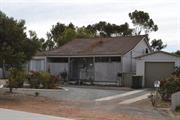
Constructed from 1907
The residence is a fine representative example of a large stylised interpretation of the Asymmetrical Front style of Australian vernacular architecture. The place, for its building form and characteristics of its class, makes a positive contribution to the streetscape and townscape of Pingelly.
The building is set back from the street alignment of Brown Street in a lawned and landscaped setting. In plan form, the building is rectangular with a central passage and rooms either side. A room projects forward beyond toward the street to form an asymmetric plan. The projecting bay is covered with a flying gable roof with timber battened eaves. A verandah encircles the building and is covered with a lean-to roof lhat is separate from the main roof. The walls above the verandah roof are rendered. The verandah roof is supported by stomp-chamfered timber posts with decorative timber brackets. The exterior of the building features decorative tall, slender corbelled brick chimneys, double-hung sash windows and a rendered band that extends across the facade at window sill height. Both side verandahs have been partly enclosed. One side is enclosed with fibro-cement lining, with louvred windows and a secondary entrance into the building. The main entrance door has a fanlight and sidelights.
Pingelly began construction with materials which were readily available in the township - stone, mud and wood. The first buildings were wood that were later replaced by mud bat and stone houses with shingles cut from local trees or thatching made from blackby rushes for the roofing. With the advent of some local industries, a need for a more adequate building programme became evident. The buildings became more uniform with the use of locally made bricks and the extensive use of corrugated iron. To a certain extent the climate dictated the housing style. To overcome the heat of summer, a bungalow was developed with four main rooms and a central passage, all or part way through the middle, with wide verandah all around, where possible, part of which was allocated as bathroom and laundry and kitchen. As the family grew, it was common to add enclosed areas as sleepouts. However, often finance did not permit four main rooms so two large rooms and a lean-to at the back sufficed, with additions being added when possible. Wood - was used sparingly in Pingelly. It was economical and uncomplicated but due to the local brick industry it was not used to its fullest potential. Masonry - brick, and to a much lesser extent stone, provided the bulk of the building construction. Stonework was mainly used in the first houses of Pingelly along with mud bats. With the advent of locally made bricks, the use of stonework was diminished to only large buildings, especially the churches. Corrugated iron - cgi was used extensively for roofing. It was also used for wall cladding, lining of eaves and in some cases ceiling linings. The extensive use of cgi expressed the importance of it as a building element.
Moderate-High
Good
| Ref ID No | Ref Name | Ref Source | Ref Date |
|---|---|---|---|
| Town Planning Scheme No.2 | 12/11/1991 |
| Ref Number | Description |
|---|---|
| 05936 | Heritage Place No. |
| Reserve | Lot/Location | Plan/Diagram | Vol/Folio |
|---|---|---|---|
| Lot 3 |
| Owner | Category |
|---|---|
| D Kirk | Other Private |
| JS Watts | Other Private |
This information is provided voluntarily as a public service. The information provided is made available in good faith and is derived from sources believed to be reliable and accurate. However, the information is provided solely on the basis that readers will be responsible for making their own assessment of the matters discussed herein and are advised to verify all relevant representations, statements and information.
Lot 835 Brown St Pingelly
Pioneer Tavern Park
Pingelly
Wheatbelt
Constructed from 1979
| Type | Status | Date | Documents |
|---|---|---|---|
| (no listings) |
| Type | Status | Date | Documents |
|---|---|---|---|
| (no listings) |
| Type | Status | Date | Grading/Management | |
|---|---|---|---|---|
| Category | ||||
| Municipal Inventory | Adopted | 28 Nov 1996 | Category 3 | |
| Name | Type | Year From | Year To |
|---|---|---|---|
| T. Puik | Architect | - | - |
Urban Park
| Epoch | General | Specific |
|---|---|---|
| Original Use | PARK\RESERVE | Park\Reserve |
| Present Use | PARK\RESERVE | Park\Reserve |
| General | Specific |
|---|---|
| OUTSIDE INFLUENCES | Tourism |
This information is provided voluntarily as a public service. The information provided is made available in good faith and is derived from sources believed to be reliable and accurate. However, the information is provided solely on the basis that readers will be responsible for making their own assessment of the matters discussed herein and are advised to verify all relevant representations, statements and information.

Constructed from 1979
The place has social value, as a demonstration of the civic pride felt by the local community who wanted to improve the appearance of their town.
Pioneer Park is located beside the Avon River within a lawned area with established palm trees, native trees and gardens with BBQ facilities and timber seats. A small timber footbridge crosses the river. The area was originally used by the early European settlers to make bricks for the first buildings in the town. The creation of the park entailed the building of two bridges, rock work, and the planting of trees. Pioneer Park has three memorials: Ingram Well - Aboriginal Supply prior to 1879. The well was used by gangs, who contributed to the construction of the Great Southern Railway, and sub settlers being the town's first supply and which is still in use. The stonework and plaque was placed in 1980, by the Pioneer Park Committee who stoned the area to preserve its history. A stone fountain on a random rubble base with a plaque that was unveiled on 12 October 1979, and which commemorates those who settled in the district. A grave stone built by the Aborigines to commemorate their own people, with a concrete base and headstone with inlaid coloured stones and a boomerang shaped motif.
Ideas to create 'Pioneer park' had their origins in 1964 when Mrs E. Frusher wrote to the Shire suggesting that the area, east of the railway line, be cleared of all debris and in this setting, paths and seating, plus a limited amount of beautification, would be most attractive. Meetings were held during 1972 and 1973 and in 1974 a Tourist and Town Beautification Committee was formed. A survey of the town was undertaken, a publicity campaign followed and letters send to all residents. The first objective of the Committee was to gain control of the eight acres of Railway land. The idea was to beautify the land and make it into a 'Pioneer Park' a memorial to the early settlers of Pingelly. The Council carried out negotiations with the WAGR for the land to be vested in the Shire Council. Under the guidance of a Perth landscape architect, Mr Puik, work began on the site. Local citizens planted trees, a playground area and barbecue were erected. During 1978, while planning for the States 150th celebrations, Committee members decided to have an official opening of 'Pioneer Park' and to mark the occasion with the installation of two fountains, one constructed of local stone. Messrs C. Stewart, A. Marshall and N. White erected an imposing entrance and a fountain established in the centre of the lake. During 'Back to Pingelly Week' in 1979, the Hon. H. W. Gayfer MLA officially opened 'Pioneer Park' unveiling a plaque on the fountain to mark the occasion. In 1980 the original town well was reconstructed in stonework, marking another historical site.
High
Good
| Name | Type | Year From | Year To |
|---|---|---|---|
| T. Puik (Landscaper) | Architect | - | - |
| Ref ID No | Ref Name | Ref Source | Ref Date |
|---|---|---|---|
| Lange, S. "Pingelly:Our People and Progress" p. 200 | The Pingelly Tourist Trust | 1981 |
| Ref Number | Description |
|---|---|
| 05908 | Heritage Place No. |
| Reserve | Lot/Location | Plan/Diagram | Vol/Folio |
|---|---|---|---|
| 34570 | Lot 835/Lot 833 |
| Owner | Category |
|---|---|
| Shire of Pingelly | Local Gov't |
This information is provided voluntarily as a public service. The information provided is made available in good faith and is derived from sources believed to be reliable and accurate. However, the information is provided solely on the basis that readers will be responsible for making their own assessment of the matters discussed herein and are advised to verify all relevant representations, statements and information.
8 Eliot St Pingelly
Kulyalling School House
Pingelly
Wheatbelt
Constructed from 1923
| Type | Status | Date | Documents |
|---|---|---|---|
| (no listings) |
| Type | Status | Date | Documents |
|---|---|---|---|
| (no listings) |
| Type | Status | Date | Grading/Management | |
|---|---|---|---|---|
| Category | ||||
| Municipal Inventory | Adopted | 28 Nov 1996 | Category 5 | |
Individual Building or Group
| Epoch | General | Specific |
|---|---|---|
| Original Use | EDUCATIONAL | Primary School |
| Present Use | RESIDENTIAL | Single storey residence |
| Type | General | Specific |
|---|---|---|
| Roof | TILE | Other Tile |
| Wall | TIMBER | Weatherboard |
| General | Specific |
|---|---|
| SOCIAL & CIVIC ACTIVITIES | Education & science |
This information is provided voluntarily as a public service. The information provided is made available in good faith and is derived from sources believed to be reliable and accurate. However, the information is provided solely on the basis that readers will be responsible for making their own assessment of the matters discussed herein and are advised to verify all relevant representations, statements and information.
Constructed from 1923
The place has historic value, as a demonstration of the different ways in which a building was used as circumstances changed.
The structure was built as a four-roomed timber framed school house. In 1946, the residence was moved and rebuilt in Eliot Street to house Bill Turton, the then resident teacher. The Education Department subsequently disposed of the place. Since the house has been relocated, the place has been extended with a verandah along the west elevation and enclosed. A patio and bathroom have been added, and the roof has been recovered.
Kulyalling was located just north of Pingelly, the townsite springing up as a construction camp during the Great Southern Railway project in 1886-1889.Providing education facilities often proved difficult for the early settlers. However, because of the frequency of the train service it was possible for the children of Kulyalling to travel to Pingelly. In 1905, a one room school was built east of the line with single teacher accommodation and duly opened. However, it became apparent that more suitable accommodation was required and so in c.1923 a four-roomed timber school was provided. The introduction of school buses in 1946 saw the teacher accompany pupils into Pingelly to attend school. School buses sounded the death knell for small schools and disused school buildings were sold and often moved to where they were needed.
Moderate-High
Good
| Ref Number | Description |
|---|---|
| 05928 | Heritage Place No. |
| Reserve | Lot/Location | Plan/Diagram | Vol/Folio |
|---|---|---|---|
| Lot 43 |
| Owner | Category |
|---|---|
| Education Dep't | State Gov't |
| G & G Kemp | Other Private |
This information is provided voluntarily as a public service. The information provided is made available in good faith and is derived from sources believed to be reliable and accurate. However, the information is provided solely on the basis that readers will be responsible for making their own assessment of the matters discussed herein and are advised to verify all relevant representations, statements and information.
Hotham River Pingelly
Pingelly
Wheatbelt
| Type | Status | Date | Documents |
|---|---|---|---|
| (no listings) |
| Type | Status | Date | Documents |
|---|---|---|---|
| (no listings) |
| Type | Status | Date | Grading/Management | |
|---|---|---|---|---|
| Category | ||||
| Municipal Inventory | Adopted | 28 Nov 1996 | ||
Historic Site
| Epoch | General | Specific |
|---|---|---|
| Original Use | MONUMENT\CEMETERY | Grave |
| Present Use | MONUMENT\CEMETERY | Grave |
This information is provided voluntarily as a public service. The information provided is made available in good faith and is derived from sources believed to be reliable and accurate. However, the information is provided solely on the basis that readers will be responsible for making their own assessment of the matters discussed herein and are advised to verify all relevant representations, statements and information.
This information is provided voluntarily as a public service. The information provided is made available in good faith and is derived from sources believed to be reliable and accurate. However, the information is provided solely on the basis that readers will be responsible for making their own assessment of the matters discussed herein and are advised to verify all relevant representations, statements and information.
Markegin Cemetery nr Pingelly
Pingelly
Wheatbelt
| Type | Status | Date | Documents |
|---|---|---|---|
| (no listings) |
| Type | Status | Date | Documents |
|---|---|---|---|
| (no listings) |
| Type | Status | Date | Grading/Management | |
|---|---|---|---|---|
| Category | ||||
| (no listings) | ||||
Historic Site
| Epoch | General | Specific |
|---|---|---|
| Present Use | MONUMENT\CEMETERY | Grave |
| Original Use | MONUMENT\CEMETERY | Grave |
This information is provided voluntarily as a public service. The information provided is made available in good faith and is derived from sources believed to be reliable and accurate. However, the information is provided solely on the basis that readers will be responsible for making their own assessment of the matters discussed herein and are advised to verify all relevant representations, statements and information.
Napping Pool Rd Pingelly
MRWA 3106
Pingelly
Wheatbelt
Constructed from 1922 to 1978
| Type | Status | Date | Documents |
|---|---|---|---|
| (no listings) |
| Type | Status | Date | Documents |
|---|---|---|---|
| RHP - Does not warrant assessment | Current | 13 Feb 2004 |
| Type | Status | Date | Grading/Management | |
|---|---|---|---|---|
| Category | ||||
| Statewide Lge Timber Str Survey | Completed | 11 Dec 1998 | ||
Historic site
| Epoch | General | Specific |
|---|---|---|
| Original Use | Transport\Communications | Road: Bridge |
| Present Use | Transport\Communications | Road: Bridge |
| Type | General | Specific |
|---|---|---|
| Other | TIMBER | Other Timber |
This information is provided voluntarily as a public service. The information provided is made available in good faith and is derived from sources believed to be reliable and accurate. However, the information is provided solely on the basis that readers will be responsible for making their own assessment of the matters discussed herein and are advised to verify all relevant representations, statements and information.
North Wandering Rd Pingelly
Pingelly
Wheatbelt
| Type | Status | Date | Documents |
|---|---|---|---|
| (no listings) |
| Type | Status | Date | Documents |
|---|---|---|---|
| (no listings) |
| Type | Status | Date | Grading/Management | |
|---|---|---|---|---|
| Category | ||||
| (no listings) | ||||
Historic Site
| Epoch | General | Specific |
|---|---|---|
| Present Use | MONUMENT\CEMETERY | Grave |
| Original Use | MONUMENT\CEMETERY | Grave |
This information is provided voluntarily as a public service. The information provided is made available in good faith and is derived from sources believed to be reliable and accurate. However, the information is provided solely on the basis that readers will be responsible for making their own assessment of the matters discussed herein and are advised to verify all relevant representations, statements and information.

11 Parade St Pingelly
Pingelly
Wheatbelt
Constructed from 1922
| Type | Status | Date | Documents |
|---|---|---|---|
| (no listings) |
| Type | Status | Date | Documents |
|---|---|---|---|
| (no listings) |
| Type | Status | Date | Grading/Management | |
|---|---|---|---|---|
| Category | ||||
| Municipal Inventory | Adopted | 28 Nov 1996 | Category 3 | |
| Statewide War Memorial Survey | Completed | 01 May 1996 | ||
Urban Park
| Epoch | General | Specific |
|---|---|---|
| Original Use | PARK\RESERVE | Park\Reserve |
| Present Use | PARK\RESERVE | Park\Reserve |
| Other Use | MONUMENT\CEMETERY | Monument |
| General | Specific |
|---|---|
| OUTSIDE INFLUENCES | World Wars & other wars |
This information is provided voluntarily as a public service. The information provided is made available in good faith and is derived from sources believed to be reliable and accurate. However, the information is provided solely on the basis that readers will be responsible for making their own assessment of the matters discussed herein and are advised to verify all relevant representations, statements and information.

The park, in its location on the south-west corner of Parade and Pasture Streets, a prominent corner in the centre of the commercial area of Pingelly, with its lawned and established trees and garden beds, is a pleasing relief to the urban streetscape of Parade Street.
The park is on the south-west corner of Parade and Pasture Streets, a prominent corner in the centre of the commercial area of Pingelly. The park relieves the urban streetscape of Parade Street. The park is lawned with established trees and garden beds. The main entrance to the park is from the north-east comer. The entrance is via a paved path with a curved low random rubble stone wall either side. One wall has a plaque which commemorates the supply of water to the town from Wellington Dam under the comprehensive water Supply Scheme. Behind the walls, two tall pine trees frame the entrance. The boundary of the park is fenced by random rubble stone garden beds along the Pasture Street elevation, and a low brick wall that forms a long, narrow garden bed along the Parade Street elevation, with a short picket fence behind. A pine log fence is along the other boundaries. The entrance path leads to a memorial in the centre of the park. The memorial is comprises an octagonal-shaped gazebo. The gazebo has a timber framed octagonal roof covered in terra-cotta tiles that is supported by square timber posts on a low brick rendered wall. The underside of the gazebo roof is decorated with a timber frieze. Random rubble stone garden beds surround the exterior of the gazebo. The floor of the interior of the gazebo is concrete. Marble plaques are secured to two facets of the exterior walls and to one facet of the interior. The plaques are inscribed and were erected in memory of those men who enlisted from the Pingelly district and died on active service in 1914-1919 and 1939-1945. The park contains painted metal furniture, bench seat and bin. A clock on a stone pedestal stands on the pavement outside the north-west corner of the park. The clock is a reproduction piece and does not form part of this assessment.
The present site of the 'Memorial Park' remained a vacant lot, and a short cut, and general parking until 1922, when Stepheno James was given the job of ploughing it. However, due to the constant use by people, vehicles and animals, it was too hard. It was later developed as a Park, being a memorial to those who lost their lives in the World Wars.
High
Good
| Ref Number | Description |
|---|---|
| 02250 | Heritage Place No. |
| 2250 | Database No. |
| Reserve | Lot/Location | Plan/Diagram | Vol/Folio |
|---|---|---|---|
| 17942 | Lot 135 |
| Owner | Category |
|---|---|
| Shire of Pingelly | Local Gov't |
This information is provided voluntarily as a public service. The information provided is made available in good faith and is derived from sources believed to be reliable and accurate. However, the information is provided solely on the basis that readers will be responsible for making their own assessment of the matters discussed herein and are advised to verify all relevant representations, statements and information.