Local Government
Plantagenet
Region
Great Southern

17 Lowood Rd Mount Barker
Mt Barker Coffee Lounge
Plantagenet
Great Southern
Constructed from 1928
| Type | Status | Date | Documents |
|---|---|---|---|
| (no listings) |
| Type | Status | Date | Documents |
|---|---|---|---|
| (no listings) |
| Type | Status | Date | Grading/Management | |
|---|---|---|---|---|
| Category | ||||
| Statewide Bank Survey | Completed | 01 Nov 1997 | ||
| Municipal Inventory | Adopted | 24 Mar 1998 | ||
Individual Building or Group
| Epoch | General | Specific |
|---|---|---|
| Present Use | COMMERCIAL | Restaurant |
| Other Use | HEALTH | Other |
| Original Use | COMMERCIAL | Bank |
| Style |
|---|
| Inter-War Free Classical |
| Type | General | Specific |
|---|---|---|
| Roof | METAL | Corrugated Iron |
| Wall | BRICK | Common Brick |
| Wall | RENDER | Cement Dressed |
| General | Specific |
|---|---|
| OCCUPATIONS | Commercial & service industries |
This information is provided voluntarily as a public service. The information provided is made available in good faith and is derived from sources believed to be reliable and accurate. However, the information is provided solely on the basis that readers will be responsible for making their own assessment of the matters discussed herein and are advised to verify all relevant representations, statements and information.
Constructed from 1928
This information is provided voluntarily as a public service. The information provided is made available in good faith and is derived from sources believed to be reliable and accurate. However, the information is provided solely on the basis that readers will be responsible for making their own assessment of the matters discussed herein and are advised to verify all relevant representations, statements and information.
Cnr Lowood Rd & McDonald Av Mount Barker
Plantagenet
Great Southern
Constructed from 1889
| Type | Status | Date | Documents |
|---|---|---|---|
| (no listings) |
| Type | Status | Date | Documents |
|---|---|---|---|
| (no listings) |
| Type | Status | Date | Grading/Management | |
|---|---|---|---|---|
| Category | ||||
| Municipal Inventory | Adopted | 24 Mar 1998 | ||
Other Built Type
| Epoch | General | Specific |
|---|---|---|
| Original Use | Transport\Communications | Rail: Water Tower |
| Present Use | GOVERNMENTAL | Reservoir or Dam |
| General | Specific |
|---|---|
| TRANSPORT & COMMUNICATIONS | Rail & light rail transport |
This information is provided voluntarily as a public service. The information provided is made available in good faith and is derived from sources believed to be reliable and accurate. However, the information is provided solely on the basis that readers will be responsible for making their own assessment of the matters discussed herein and are advised to verify all relevant representations, statements and information.
Constructed from 1889
This information is provided voluntarily as a public service. The information provided is made available in good faith and is derived from sources believed to be reliable and accurate. However, the information is provided solely on the basis that readers will be responsible for making their own assessment of the matters discussed herein and are advised to verify all relevant representations, statements and information.

Cnr Lowood Rd & Muir St Mount Barker
Bottom Pub
Plantagenet Hotel
Plantagenet
Great Southern
Constructed from 1912 to 1914
| Type | Status | Date | Documents |
|---|---|---|---|
| (no listings) |
| Type | Status | Date | Documents |
|---|---|---|---|
| (no listings) |
| Type | Status | Date | Grading/Management | |
|---|---|---|---|---|
| Category | ||||
| Statewide Hotel Survey | Completed | 01 Nov 1997 | ||
| Municipal Inventory | Adopted | 24 Mar 1998 | ||
Individual Building or Group
| Epoch | General | Specific |
|---|---|---|
| Original Use | COMMERCIAL | Hotel, Tavern or Inn |
| Present Use | COMMERCIAL | Hotel, Tavern or Inn |
| Type | General | Specific |
|---|---|---|
| Wall | BRICK | Common Brick |
| Roof | METAL | Corrugated Iron |
| General | Specific |
|---|---|
| OCCUPATIONS | Hospitality industry & tourism |
This information is provided voluntarily as a public service. The information provided is made available in good faith and is derived from sources believed to be reliable and accurate. However, the information is provided solely on the basis that readers will be responsible for making their own assessment of the matters discussed herein and are advised to verify all relevant representations, statements and information.
Constructed from 1914, Constructed from 1912
The Plantagenet Hotel, or Park Hotel as it was previously known, has been a significant meeting place for the local community for many years. In 1996 the hotel continues to be a social gathering place for the local community and for visitors to the area. The large open fire in the loung area is an attractive feature on cold wet Mount Barker evenings.
Sometimes callcd the 'Bottom Pub', it was built by the Sounness family in 1912-14. The apple motifs depict their association with large apple orchards in the area in the early part of the century (Merriup). The New Park Hotel took over the licence from the original Park Hotel (previously the Bush Inn) when it was delicensed in 1914. The name was changed to the Plantagenet Hotel in 1984.
This information is provided voluntarily as a public service. The information provided is made available in good faith and is derived from sources believed to be reliable and accurate. However, the information is provided solely on the basis that readers will be responsible for making their own assessment of the matters discussed herein and are advised to verify all relevant representations, statements and information.

Cnr Lowood Rd & Short St Mount Barker
Westpac BAnk
Plantagenet
Great Southern
Constructed from 1932
| Type | Status | Date | Documents |
|---|---|---|---|
| (no listings) |
| Type | Status | Date | Documents |
|---|---|---|---|
| (no listings) |
| Type | Status | Date | Grading/Management | |
|---|---|---|---|---|
| Category | ||||
| Municipal Inventory | Adopted | 24 Mar 1998 | ||
| Statewide Bank Survey | Completed | 01 Nov 1997 | ||
Individual Building or Group
| Epoch | General | Specific |
|---|---|---|
| Present Use | COMMERCIAL | Bank |
| Original Use | COMMERCIAL | Bank |
| Type | General | Specific |
|---|---|---|
| Wall | BRICK | Common Brick |
| Roof | METAL | Corrugated Iron |
| Wall | RENDER | Smooth |
| General | Specific |
|---|---|
| OCCUPATIONS | Commercial & service industries |
This information is provided voluntarily as a public service. The information provided is made available in good faith and is derived from sources believed to be reliable and accurate. However, the information is provided solely on the basis that readers will be responsible for making their own assessment of the matters discussed herein and are advised to verify all relevant representations, statements and information.
Constructed from 1932
This information is provided voluntarily as a public service. The information provided is made available in good faith and is derived from sources believed to be reliable and accurate. However, the information is provided solely on the basis that readers will be responsible for making their own assessment of the matters discussed herein and are advised to verify all relevant representations, statements and information.
MacDonald Av Mount Barker
Showgrounds
Plantagenet
Great Southern
Constructed from 1902
| Type | Status | Date | Documents |
|---|---|---|---|
| (no listings) |
| Type | Status | Date | Documents |
|---|---|---|---|
| (no listings) |
| Type | Status | Date | Grading/Management | |
|---|---|---|---|---|
| Category | ||||
| Municipal Inventory | Adopted | 24 Mar 1998 | ||
Individual Building or Group
| Epoch | General | Specific |
|---|---|---|
| Present Use | SOCIAL\RECREATIONAL | Other Sports Building |
| Original Use | SOCIAL\RECREATIONAL | Other Sports Building |
| Other Use | SOCIAL\RECREATIONAL | Other |
| Type | General | Specific |
|---|---|---|
| Wall | BRICK | Common Brick |
| Roof | METAL | Corrugated Iron |
| General | Specific |
|---|---|
| SOCIAL & CIVIC ACTIVITIES | Community services & utilities |
| SOCIAL & CIVIC ACTIVITIES | Sport, recreation & entertainment |
This information is provided voluntarily as a public service. The information provided is made available in good faith and is derived from sources believed to be reliable and accurate. However, the information is provided solely on the basis that readers will be responsible for making their own assessment of the matters discussed herein and are advised to verify all relevant representations, statements and information.
Constructed from 1902
This information is provided voluntarily as a public service. The information provided is made available in good faith and is derived from sources believed to be reliable and accurate. However, the information is provided solely on the basis that readers will be responsible for making their own assessment of the matters discussed herein and are advised to verify all relevant representations, statements and information.
MacDonald St Mount Barker
Old Bush Inn Hotel
Park Hotel (fmr)
Plantagenet
Great Southern
Constructed from 1860
| Type | Status | Date | Documents |
|---|---|---|---|
| Heritage List | Adopted | 17 Feb 2021 |
| Type | Status | Date | Documents |
|---|---|---|---|
| (no listings) |
| Type | Status | Date | Grading/Management | |
|---|---|---|---|---|
| Category | ||||
| Municipal Inventory | Adopted | |||
| Classified by the National Trust | Classified {HBS} | 08 Jul 1996 | ||
| Statewide Hotel Survey | Completed | 01 Nov 1997 | ||
| Register of the National Estate | Indicative Place | |||
| Library Id | Title | Medium | Year Of Publication |
|---|---|---|---|
| 739 | Report on the historical archaeological potential of the Old Coach Inn, Mount Barker. | Heritage Study {Other} | 1985 |
Individual Building or Group
| Epoch | General | Specific |
|---|---|---|
| Original Use | COMMERCIAL | Hotel, Tavern or Inn |
| Present Use | VACANT\UNUSED | Vacant\Unused |
| Type | General | Specific |
|---|---|---|
| Other | EARTH | Adobe {Mud Brick} |
| General | Specific |
|---|---|
| OCCUPATIONS | Hospitality industry & tourism |
This information is provided voluntarily as a public service. The information provided is made available in good faith and is derived from sources believed to be reliable and accurate. However, the information is provided solely on the basis that readers will be responsible for making their own assessment of the matters discussed herein and are advised to verify all relevant representations, statements and information.
Ruins
| Ref ID No | Ref Name | Ref Source | Ref Date |
|---|---|---|---|
| R Glover; "Plantagenet Rich and Beautiful". |
This information is provided voluntarily as a public service. The information provided is made available in good faith and is derived from sources believed to be reliable and accurate. However, the information is provided solely on the basis that readers will be responsible for making their own assessment of the matters discussed herein and are advised to verify all relevant representations, statements and information.
21 Menston St Mount Barker
Plantagenet Hospital
Plantagenet
Great Southern
Constructed from 1910 to 1920
| Type | Status | Date | Documents |
|---|---|---|---|
| (no listings) |
| Type | Status | Date | Documents |
|---|---|---|---|
| (no listings) |
| Type | Status | Date | Grading/Management | |
|---|---|---|---|---|
| Category | ||||
| Municipal Inventory | Adopted | 24 Mar 1998 | ||
Individual Building or Group
| Epoch | General | Specific |
|---|---|---|
| Other Use | HEALTH | Hospital |
| Present Use | RESIDENTIAL | Single storey residence |
| Original Use | RESIDENTIAL | Single storey residence |
| Type | General | Specific |
|---|---|---|
| Roof | METAL | Corrugated Iron |
| Wall | STONE | Local Stone |
| General | Specific |
|---|---|
| SOCIAL & CIVIC ACTIVITIES | Community services & utilities |
This information is provided voluntarily as a public service. The information provided is made available in good faith and is derived from sources believed to be reliable and accurate. However, the information is provided solely on the basis that readers will be responsible for making their own assessment of the matters discussed herein and are advised to verify all relevant representations, statements and information.
Constructed from 1910, Constructed from 1920
| Ref ID No | Ref Name | Ref Source | Ref Date |
|---|---|---|---|
| Photographs taken June 1995 | 1995 |
This information is provided voluntarily as a public service. The information provided is made available in good faith and is derived from sources believed to be reliable and accurate. However, the information is provided solely on the basis that readers will be responsible for making their own assessment of the matters discussed herein and are advised to verify all relevant representations, statements and information.
40 Mitchell Street Mount Barker
Previously at 20 Albany Highway, Mount Barker
James Sounness's House
Plantagenet
Great Southern
Constructed from 1869
| Type | Status | Date | Documents |
|---|---|---|---|
| (no listings) |
| Type | Status | Date | Documents |
|---|---|---|---|
| (no listings) |
| Type | Status | Date | Grading/Management | |
|---|---|---|---|---|
| Category | ||||
| Classified by the National Trust | Classified | 02 Nov 1992 | ||
| Municipal Inventory | Adopted | 24 Mar 1998 | ||
| Name | Type | Year From | Year To |
|---|---|---|---|
| James Sounness | Architect | - | - |
Individual Building or Group
| Epoch | General | Specific |
|---|---|---|
| Original Use | RESIDENTIAL | Single storey residence |
| Original Use | COMMERCIAL | Shop\Retail Store {single} |
| Present Use | RESIDENTIAL | Single storey residence |
| Type | General | Specific |
|---|---|---|
| Roof | EARTH | Other Earth |
| Wall | EARTH | Other Earth |
| General | Specific |
|---|---|
| OCCUPATIONS | Commercial & service industries |
This information is provided voluntarily as a public service. The information provided is made available in good faith and is derived from sources believed to be reliable and accurate. However, the information is provided solely on the basis that readers will be responsible for making their own assessment of the matters discussed herein and are advised to verify all relevant representations, statements and information.
Constructed from 1869
Abbevholme is historically important as it is connected to the Sounness family, pioneers of the Mount Barker district. It was one of the earliest buildings in the area, following after the Bush Inn and the Police Station. The construction and additions illustrate the practice of increasing the size of a dwelling, first with stone and then with asbestos. The use of the building has changed from dwelling to store and then back to residential. In recent years it was a Bed and Breakfast establishment catering for tourists. In 1996 the homestead was for sale, no longer operating as a Bed and Breakfast establishment. Early in 1997 the new owner has plans to establish an antique gallery and restaurant on the property.
| Name | Type | Year From | Year To |
|---|---|---|---|
| James Sounness | Architect | 1869 | - |
| Ref ID No | Ref Name | Ref Source | Ref Date |
|---|---|---|---|
| Information from new owner. L Dougall | |||
| National Trust Assessment Form: | |||
| Articles by Nanette Clutterbuck (stored with original form). |
This information is provided voluntarily as a public service. The information provided is made available in good faith and is derived from sources believed to be reliable and accurate. However, the information is provided solely on the basis that readers will be responsible for making their own assessment of the matters discussed herein and are advised to verify all relevant representations, statements and information.

Mt Barker St Mount Barker
Plantagenet
Great Southern
Constructed from 1957
| Type | Status | Date | Documents |
|---|---|---|---|
| (no listings) |
| Type | Status | Date | Documents |
|---|---|---|---|
| RHP - To be assessed | Current | 28 Sep 2012 |
| Type | Status | Date | Grading/Management | |
|---|---|---|---|---|
| Category | ||||
| (no listings) | ||||
Still in use as a Police Station and quarters. Quarters are with GROH on Police Reserve (March 2010).
Individual Building or Group
| Epoch | General | Specific |
|---|---|---|
| Present Use | GOVERNMENTAL | Police Station or Quarters |
| Original Use | GOVERNMENTAL | Police Station or Quarters |
| Style |
|---|
| Late 20th-Century Perth Regional |
| Type | General | Specific |
|---|---|---|
| Wall | BRICK | Common Brick |
| Roof | TILE | Terracotta Tile |
| General | Specific |
|---|---|
| SOCIAL & CIVIC ACTIVITIES | Law & order |
This information is provided voluntarily as a public service. The information provided is made available in good faith and is derived from sources believed to be reliable and accurate. However, the information is provided solely on the basis that readers will be responsible for making their own assessment of the matters discussed herein and are advised to verify all relevant representations, statements and information.

Mt Barker St Mount Barker
Plantagenet
Great Southern
Constructed from 1957
| Type | Status | Date | Documents |
|---|---|---|---|
| (no listings) |
| Type | Status | Date | Documents |
|---|---|---|---|
| (no listings) |
| Type | Status | Date | Grading/Management | |
|---|---|---|---|---|
| Category | ||||
| (no listings) | ||||
02279 Mount Barker Court House and Police Station
Still in use as a Police Station and quarters. Quarters are with GROH on Police Reserve (March 2010).
Individual Building or Group
| Epoch | General | Specific |
|---|---|---|
| Present Use | GOVERNMENTAL | Police Station or Quarters |
| Original Use | GOVERNMENTAL | Police Station or Quarters |
| Style |
|---|
| Late 20th-Century Perth Regional |
| Type | General | Specific |
|---|---|---|
| Wall | BRICK | Common Brick |
| Roof | TILE | Terracotta Tile |
| General | Specific |
|---|---|
| SOCIAL & CIVIC ACTIVITIES | Law & order |
This information is provided voluntarily as a public service. The information provided is made available in good faith and is derived from sources believed to be reliable and accurate. However, the information is provided solely on the basis that readers will be responsible for making their own assessment of the matters discussed herein and are advised to verify all relevant representations, statements and information.
Muir St Mount Barker
Plantagenet
Great Southern
Constructed from 1922
| Type | Status | Date | Documents |
|---|---|---|---|
| (no listings) |
| Type | Status | Date | Documents |
|---|---|---|---|
| (no listings) |
| Type | Status | Date | Grading/Management | |
|---|---|---|---|---|
| Category | ||||
| Municipal Inventory | Adopted | 24 Mar 1998 | ||
Individual Building or Group
| Epoch | General | Specific |
|---|---|---|
| Present Use | SOCIAL\RECREATIONAL | Masonic Hall |
| Original Use | SOCIAL\RECREATIONAL | Masonic Hall |
| Type | General | Specific |
|---|---|---|
| Roof | METAL | Corrugated Iron |
| Wall | STONE | Other Stone |
| General | Specific |
|---|---|
| SOCIAL & CIVIC ACTIVITIES | Institutions |
This information is provided voluntarily as a public service. The information provided is made available in good faith and is derived from sources believed to be reliable and accurate. However, the information is provided solely on the basis that readers will be responsible for making their own assessment of the matters discussed herein and are advised to verify all relevant representations, statements and information.
Constructed from 1922
This information is provided voluntarily as a public service. The information provided is made available in good faith and is derived from sources believed to be reliable and accurate. However, the information is provided solely on the basis that readers will be responsible for making their own assessment of the matters discussed herein and are advised to verify all relevant representations, statements and information.
Muir St Mount Barker
Plantagenet
Great Southern
Constructed from 1900
| Type | Status | Date | Documents |
|---|---|---|---|
| (no listings) |
| Type | Status | Date | Documents |
|---|---|---|---|
| (no listings) |
| Type | Status | Date | Grading/Management | |
|---|---|---|---|---|
| Category | ||||
| Statewide War Memorial Survey | Completed | 01 May 1996 | ||
Historic site
| Epoch | General | Specific |
|---|---|---|
| Present Use | MONUMENT\CEMETERY | Monument |
| Original Use | MONUMENT\CEMETERY | Monument |
| General | Specific |
|---|---|
| OUTSIDE INFLUENCES | World Wars & other wars |
This information is provided voluntarily as a public service. The information provided is made available in good faith and is derived from sources believed to be reliable and accurate. However, the information is provided solely on the basis that readers will be responsible for making their own assessment of the matters discussed herein and are advised to verify all relevant representations, statements and information.
Muirs Hwy Mount Barker
Goundrey Wines
Plantagenet
Great Southern
Constructed from 1936
| Type | Status | Date | Documents |
|---|---|---|---|
| (no listings) |
| Type | Status | Date | Documents |
|---|---|---|---|
| (no listings) |
| Type | Status | Date | Grading/Management | |
|---|---|---|---|---|
| Category | ||||
| Municipal Inventory | Adopted | 24 Mar 1998 | ||
Individual Building or Group
| Epoch | General | Specific |
|---|---|---|
| Present Use | INDUSTRIAL\MANUFACTURING | Winery |
| Other Use | COMMERCIAL | Other |
| Original Use | FARMING\PASTORAL | Homestead |
| Type | General | Specific |
|---|---|---|
| Wall | TIMBER | Other Timber |
| Roof | METAL | Corrugated Iron |
| General | Specific |
|---|---|
| OCCUPATIONS | Grazing, pastoralism & dairying |
This information is provided voluntarily as a public service. The information provided is made available in good faith and is derived from sources believed to be reliable and accurate. However, the information is provided solely on the basis that readers will be responsible for making their own assessment of the matters discussed herein and are advised to verify all relevant representations, statements and information.
The original residence was one of the first farm dwellings on the Muir Highway. The property was taken up in 1839 by Sir Richard Spencer, the Government Resident at the time. He was also the first farmer in Western Australia, taking up land at Strawberry Hill in Albany. When his sheep were affected by disease at the Strawberry Hill Farm, he moved the flock inland to the Hay River properly. The property later passed to his son, Edward May Spencer, whose executors sold it to Sir Alexander Cockburn-Campbell in 1865. Sir Alexander died in 1871 and the property passed to his son. Sir Thomas Cockburn-Campbell who named the property 'Langton' after the name of the family estate,- 'Langton Park', in England. After his death the farm remained in the family, but was leased to the Egerton -Warburton brothers, who used it as a sheep run. In 1883 William Wallace Mitchell purchased Langton. Mitchell was a progressive farmer, planting orchards and some vines for personal use. He pioneered the growth of clover to improve his flocks and also grew chaff. In 1928 the property passed to his nephew, Clayton Mitchell, who was later ML A for Stirling for nine years and was the first President of the Plantagenet Shire Council. During his time the property became a leading apple producer in the district. Later the importance of apples to the district declined in favour of wheat and cereals. In 1987 Goundrey Wines Ltd purchased 'Langton' and the cool climate made it ideal for introducing viticulture into the district. After 1997 there will be 190 hectares of excellent vineyard on the slopes of the property. The modern winery building was erected cl988. For some years the house was used as a tearoom, and for offices and cellar sales. Plans are underway to renovate the homestead to its original plan over the coming years. It will be used to house memorabilia and for functions. Langton has recently changed hands, and the new owner, Mr Bendat. is undertaking significant expansion and development of the property and will continue to produce wine under the Goundrey label. The enterprise forms a valuable tourist asset in the district. Goundrey Wines has won many awards for their quality wines.
| Ref ID No | Ref Name | Ref Source | Ref Date |
|---|---|---|---|
| Information from Goundrey Wines |
| Owner | Category |
|---|---|
| Mr Bendat. | Other Private |
This information is provided voluntarily as a public service. The information provided is made available in good faith and is derived from sources believed to be reliable and accurate. However, the information is provided solely on the basis that readers will be responsible for making their own assessment of the matters discussed herein and are advised to verify all relevant representations, statements and information.
Muirs Hwy Mount Barker
Plantagenet
Great Southern
Constructed from 1900
| Type | Status | Date | Documents |
|---|---|---|---|
| (no listings) |
| Type | Status | Date | Documents |
|---|---|---|---|
| (no listings) |
| Type | Status | Date | Grading/Management | |
|---|---|---|---|---|
| Category | ||||
| Municipal Inventory | Adopted | 24 Mar 1998 | ||
Individual Building or Group
| Epoch | General | Specific |
|---|---|---|
| Present Use | FARMING\PASTORAL | Homestead |
| Other Use | FARMING\PASTORAL | Stable |
| Original Use | FARMING\PASTORAL | Homestead |
| Type | General | Specific |
|---|---|---|
| Roof | METAL | Corrugated Iron |
| Wall | STONE | Local Stone |
| General | Specific |
|---|---|
| OCCUPATIONS | Grazing, pastoralism & dairying |
This information is provided voluntarily as a public service. The information provided is made available in good faith and is derived from sources believed to be reliable and accurate. However, the information is provided solely on the basis that readers will be responsible for making their own assessment of the matters discussed herein and are advised to verify all relevant representations, statements and information.
Constructed from 1900
This information is provided voluntarily as a public service. The information provided is made available in good faith and is derived from sources believed to be reliable and accurate. However, the information is provided solely on the basis that readers will be responsible for making their own assessment of the matters discussed herein and are advised to verify all relevant representations, statements and information.
Oatlands Rd Mount Barker
Reserve #31528
Plantagenet
Great Southern
Constructed from 1933
| Type | Status | Date | Documents |
|---|---|---|---|
| (no listings) |
| Type | Status | Date | Documents |
|---|---|---|---|
| RHP - Assessed - Below Threshold | Current | 29 Sep 2006 |
| Type | Status | Date | Grading/Management | |
|---|---|---|---|---|
| Category | ||||
| (no listings) | ||||
Individual Building or Group
| Epoch | General | Specific |
|---|---|---|
| Original Use | EDUCATIONAL | Primary School |
| Original Use | EDUCATIONAL | Housing or Quarters |
| Type | General | Specific |
|---|---|---|
| Roof | TILE | Ceramic Tile |
| Wall | TIMBER | Weatherboard |
| General | Specific |
|---|---|
| SOCIAL & CIVIC ACTIVITIES | Education & science |
This information is provided voluntarily as a public service. The information provided is made available in good faith and is derived from sources believed to be reliable and accurate. However, the information is provided solely on the basis that readers will be responsible for making their own assessment of the matters discussed herein and are advised to verify all relevant representations, statements and information.
Ormond Rd Mount Barker
Plantagenet
Great Southern
Constructed from 1979
| Type | Status | Date | Documents |
|---|---|---|---|
| (no listings) |
| Type | Status | Date | Documents |
|---|---|---|---|
| (no listings) |
| Type | Status | Date | Grading/Management | |
|---|---|---|---|---|
| Category | ||||
| Uniting Church Inventory | Completed | 01 Oct 1996 | ||
Individual Building or Group
| Epoch | General | Specific |
|---|---|---|
| Original Use | RELIGIOUS | Housing or Quarters |
| Present Use | RELIGIOUS | Housing or Quarters |
| Type | General | Specific |
|---|---|---|
| Wall | BRICK | Common Brick |
| Roof | TILE | Ceramic Tile |
| General | Specific |
|---|---|
| SOCIAL & CIVIC ACTIVITIES | Religion |
This information is provided voluntarily as a public service. The information provided is made available in good faith and is derived from sources believed to be reliable and accurate. However, the information is provided solely on the basis that readers will be responsible for making their own assessment of the matters discussed herein and are advised to verify all relevant representations, statements and information.
St Werburghs Rd Mount Barker
Plantagenet
Great Southern
Constructed from 1858
| Type | Status | Date | Documents |
|---|---|---|---|
| (no listings) |
| Type | Status | Date | Documents |
|---|---|---|---|
| RHP - Does not warrant assessment | Current | 22 Feb 2019 |
| Type | Status | Date | Grading/Management | |
|---|---|---|---|---|
| Category | ||||
| Register of the National Estate | Indicative Place | |||
| Statewide Lge Timber Str Survey | Completed | 11 Dec 1998 | ||
| Classified by the National Trust | Classified {HS} | 08 Jul 1996 | ||
| Municipal Inventory | Adopted | 24 Mar 1998 | ||
Poor - ruin
Historic site
| Epoch | General | Specific |
|---|---|---|
| Present Use | VACANT\UNUSED | Vacant\Unused |
| Original Use | Transport\Communications | Road: Bridge |
| Type | General | Specific |
|---|---|---|
| Other | TIMBER | Other Timber |
| General | Specific |
|---|---|
| TRANSPORT & COMMUNICATIONS | Road transport |
This information is provided voluntarily as a public service. The information provided is made available in good faith and is derived from sources believed to be reliable and accurate. However, the information is provided solely on the basis that readers will be responsible for making their own assessment of the matters discussed herein and are advised to verify all relevant representations, statements and information.
This information is provided voluntarily as a public service. The information provided is made available in good faith and is derived from sources believed to be reliable and accurate. However, the information is provided solely on the basis that readers will be responsible for making their own assessment of the matters discussed herein and are advised to verify all relevant representations, statements and information.
St Werburghs Rd Mount Barker
Closely associated with P11074 St Werburghs Homestead. P10996 DOES NOT INCLUDE THE HOMESTEAD.
Plantagenet
Great Southern
Constructed from 1846, Constructed from 1974
| Type | Status | Date | Documents |
|---|---|---|---|
| State Register | Registered | 23 Nov 2004 | HCWebsite.Listing+ListingDocument, HCWebsite.Listing+ListingDocument |
| Type | Status | Date | Documents |
|---|---|---|---|
| (no listings) |
| Type | Status | Date | Grading/Management | |
|---|---|---|---|---|
| Category | ||||
| Aboriginal Heritage Sites Register | Permanent | |||
| Library Id | Title | Medium | Year Of Publication |
|---|---|---|---|
| 6004 | Conservation plan for St. Werburgh's Farm Buildings Mt. Barker. | Heritage Study {Cons'n Plan} | 2003 |
| 7510 | St Werburgh's farm Buildings, Mt Barker : report on works completed. | Conservation works report | 2005 |
| 9022 | St Werburgs farm buildings, Mt Barker - conservation works. | Conservation works report | 0 |
| 1565 | The way to St Werburgh's | Book | 1997 |
| 9239 | St Werburgh's farm buildings - Mt Baker - conservation works. Second and final report on works completed. | Conservation works report | 0 |
Individual Building or Group
| Epoch | General | Specific |
|---|---|---|
| Original Use | RESIDENTIAL | Single storey residence |
| Present Use | RESIDENTIAL | Single storey residence |
| Style |
|---|
| Other Style |
| Type | General | Specific |
|---|---|---|
| Roof | METAL | Corrugated Iron |
| Wall | EARTH | Adobe {Mud Brick} |
| General | Specific |
|---|---|
| OCCUPATIONS | Rural industry & market gardening |
| DEMOGRAPHIC SETTLEMENT & MOBILITY | Settlements |
| OCCUPATIONS | Grazing, pastoralism & dairying |
This information is provided voluntarily as a public service. The information provided is made available in good faith and is derived from sources believed to be reliable and accurate. However, the information is provided solely on the basis that readers will be responsible for making their own assessment of the matters discussed herein and are advised to verify all relevant representations, statements and information.
Constructed from 1974, Constructed from 1846
| Ref ID No | Ref Name | Ref Source | Ref Date |
|---|---|---|---|
| Supporting Information |
This information is provided voluntarily as a public service. The information provided is made available in good faith and is derived from sources believed to be reliable and accurate. However, the information is provided solely on the basis that readers will be responsible for making their own assessment of the matters discussed herein and are advised to verify all relevant representations, statements and information.
31712 Albany Hwy Mt Barker
Plantagenet
Great Southern
Constructed from 1958
| Type | Status | Date | Documents |
|---|---|---|---|
| Heritage Agreement | YES | 19 May 2014 | HCWebsite.Listing+ListingDocument |
| State Register | Registered | 25 Aug 2009 | HCWebsite.Listing+ListingDocument, HCWebsite.Listing+ListingDocument |
| Type | Status | Date | Documents |
|---|---|---|---|
| (no listings) |
| Type | Status | Date | Grading/Management | |
|---|---|---|---|---|
| Category | ||||
| (no listings) | ||||
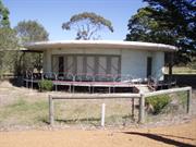
Round House, Mount Barker is in fair condition overall although leaking from the roof has destroyed introduced ceiling fabric and is causing damp to affect other fabric. The building has not been occupied for about three years and there has been no maintenance during this period. The wide overhanging eaves have protected much of the external fabric such as windows, doors and wall cladding, although the metal balustrading requires treatment and repainting.
| Name | Type | Year From | Year To |
|---|---|---|---|
| Hubertus Johannes Van der Kolk & (wfie) Anne | Architect | - | - |
| Library Id | Title | Medium | Year Of Publication |
|---|---|---|---|
| 7015 | Round House, Mt Barker : heritage assessment. | Heritage Study {Other} | 2004 |
| 7958 | Round house, Mt Barker conservation plan. | Heritage Study {Cons'n Plan} | 2006 |
Individual Building or Group
| Epoch | General | Specific |
|---|---|---|
| Present Use | VACANT\UNUSED | Vacant\Unused |
| Original Use | RESIDENTIAL | Single storey residence |
| Style |
|---|
| Post-War International |
| Type | General | Specific |
|---|---|---|
| Wall | OTHER | Other Material |
| Wall | METAL | Steel |
| Roof | METAL | Aluminium |
| General | Specific |
|---|---|
| DEMOGRAPHIC SETTLEMENT & MOBILITY | Land allocation & subdivision |
| DEMOGRAPHIC SETTLEMENT & MOBILITY | Technology & technological change |
| DEMOGRAPHIC SETTLEMENT & MOBILITY | Settlements |
| DEMOGRAPHIC SETTLEMENT & MOBILITY | Immigration, emigration & refugees |
This information is provided voluntarily as a public service. The information provided is made available in good faith and is derived from sources believed to be reliable and accurate. However, the information is provided solely on the basis that readers will be responsible for making their own assessment of the matters discussed herein and are advised to verify all relevant representations, statements and information.
Lowood Rd Mt Barker
Immediatley south of Mt Barker Railway Station on west side of railway line. Not currently within the registered curtilage of Mt Barker Railway Station curtilage.
Fruit Packing Shed, Railway Goods Shed,
Mount Barker Fruit Growers' Cool Storage Co-o
Plantagenet
Great Southern
Constructed from 1934, Constructed from 1942
| Type | Status | Date | Documents |
|---|---|---|---|
| (no listings) |
| Type | Status | Date | Documents |
|---|---|---|---|
| RHP - Assessed - Consultation (Preliminary) | Current | 29 Sep 2006 |
| Type | Status | Date | Grading/Management | |
|---|---|---|---|---|
| Category | ||||
| (no listings) | ||||
The place is rare as a purpose-built fruit packing shed associated with a major railway station in the southwest of Western Australia.
As part of the complex of railway station buildings, the place had an integral role in the export of local produce, which in turn had a significant impact on the growth of the town of Mt Barker and its surrounds.
The place represents the need for additional facilities during the expansion of the fruit growing industry in Western Australia in the 1930s.
The place represents efforts of the Mr Barker fruit growing community of the 1930s to work collectively for a more efficient means of processing their produce.
The interior remains relatively intact in comparison to other similar places that have been highly modified.
From External Site Inspection Form by Laura Gray, Heritage & Conservation Consultant. Based on photographs provided by PTA, from an inspection in early 2006: "Mount Barker Fruit Grower's Cool Storage Co-operative building (fmr) is a ‘T’ shaped building with a long rectangular 1918 building parallel along the west side of the railway line. At the south end, the 1936 rectangular form extension is at right angles from the 1918 building. There is an expansive grassed area and bitumen parking area to the west and south of the building. The 1918 building is a timber-framed structure predominantly clad with painted weatherboards. The upper sections of the walls have spaced boards that provide ventilation. There are regular sliding door openings along the east and west sides of the building. Extensions at the north end seem to be clad with horizontal corrugated asbestos sheeting. The entire gable roof is clad with corrugated asbestos sheets. There is a platform along the east side (rail side), and a bracketed awning along that length. The 1936 extension has a hipped roof, also clad with corrugated asbestos. It is mostly timber framed and clad with weatherboards and venting as for the 1918 building, including the south wall that is face brick to vente height. The interiors are unceiled, and the floors are predominantly concrete. The expansive timber truss systems are evident. There is freestanding 2.0 metre high brick walls the length of the 1918 building, and railways lines similarly within the building are aligned north south." The building is in sound condition, has moderate integrity, and high to moderate authenticity.
The township of Mt Barker originated as a resting place between Albany and Kojonup from the 1860s, gradually developing with the improvement of the road and the opening of the Great Southern Railway in the late 1880s. A prefabricated railway station building was erected in 1889 and the town grew up around this initial focal point. The railway station made it easier to dispose of farm produce, and soon the commercial life of the town was reliant on the surrounding farms and orchards (the present brick and tile railway station building was erected in 1923). By 1910 there were 75 commercial orchards in and around Mt Barker and the export of apples was a major source of income for the area, as well as pears and peas. Before refrigeration, apples were exported in barrels, and in 1917 local orchardists, unhappy with the exporting conditions, agreed to form the Mount Barker Cool Storage Co-operative. The company arranged the packing, cold storing and export of all their products. When the company was incorporated on 1 May 1918, there were 75 shareholders, all orchardists. "It [the company] purchased a small building with rail access which was immediately enlarged as a packing shed and built a cold store adjoining the packing shed. All the buildings and plant (including the refrigeration plant) were installed in readiness for the 1918 fruit season. At this time most of the fruit was packed by the growers on their own properties, but with the expansion of plantings - mainly of the Granny Smith variety in the early 1930s - growers made more use of the Mount Barker Co-op's central packing-shed facilities so that in 1936 its premises were enlarged, and new apple and pear graders installed; plus, two case-making machines. The premises were enlarged again in 1938-39, so that for the 1939 season there were five graders and three case-making machines ready to handle what turned out to be a record crop. With the outbreak of World War II all apples and pears were acquired by the federal Government and the Mount Barker Co-op packed and cold stored that fruit produced in the district under contract for the Australian Apple and Pear Marketing Board." Glover, R (1979) p350. The Co-op expanded its holdings and diversified into farm merchandise, seed cleaning and grading after the end of the war. Yearly fruit production declined from the 1960s and the Co-op closed the packing shed in 1975. Extensive alterations were made to transfer the shed into a retail complex. It was officially opened on 24 July 1978. The railway station remained in use until 1978 when the passenger service between Perth and Albany was discontinued. The railway station building was permanently registered in June 1995, based on the March 1994 Conservation Plan by Pinder Architects Pty Ltd and Bruce Harry & Assoc. Conservation Architects. Although the consultants did not recommend, they be included in the curtilage of the registration, the statement of significance notes the "associated former fruit packing and cold stores to the south are of some interest for their representation of a historical period in Mt Barker's economic development and help to give context to the railway station buildings" (p53). In the mid 1990s the fruit packing shed was used as a wool store. Photographs indicate it has been painted since the completion of the railway station conservation plan (1994) and the present.
Mount Barker Fruit Inspection & Dehydration Shed (fmr) is in fair condition. There is evidence of structural subsidence on the west side, extensive termite damage, deteriorated asbestos cement fabric on the roofs, and weathered timbers. On the interior, vandalism is particularly evident in the offices where wall cladding has been smashed, and ceilings damaged and partially removed. No maintenance takes place.
| Name | Type | Year From | Year To |
|---|---|---|---|
| Brockmill Pty Ltd (fmr storage tenant) | Architect | - | - |
| Library Id | Title | Medium | Year Of Publication |
|---|---|---|---|
| 9113 | Fruit inspection and dehydration shed Mount barker. Investigation of condition and repair recommendations. | Heritage Study {Other} | 2007 |
| 9786 | Mt Barker fruit inspection and dehydration shed (fmr): adaptive re-use study. | Heritage Study {Other} | 2009 |
Individual Building or Group
| Epoch | General | Specific |
|---|---|---|
| Original Use | INDUSTRIAL\MANUFACTURING | Other |
| Present Use | VACANT\UNUSED | Vacant\Unused |
| Other Use | Transport\Communications | Rail: Other |
| Style |
|---|
| Vernacular |
| Type | General | Specific |
|---|---|---|
| Wall | ASBESTOS | Fibrous Cement, corrugated |
| Wall | TIMBER | Weatherboard |
| General | Specific |
|---|---|
| OCCUPATIONS | Rural industry & market gardening |
| TRANSPORT & COMMUNICATIONS | Rail & light rail transport |
This information is provided voluntarily as a public service. The information provided is made available in good faith and is derived from sources believed to be reliable and accurate. However, the information is provided solely on the basis that readers will be responsible for making their own assessment of the matters discussed herein and are advised to verify all relevant representations, statements and information.