Local Government
Ravensthorpe
Region
Goldfields
Lot 459 Canning St Hopetoun
Ravensthorpe
Goldfields
Constructed from 1907
| Type | Status | Date | Documents |
|---|---|---|---|
| (no listings) |
| Type | Status | Date | Documents |
|---|---|---|---|
| RHP - Does not warrant assessment | Current | 13 Mar 2020 |
| Type | Status | Date | Grading/Management | |
|---|---|---|---|---|
| Category | ||||
| Municipal Inventory | Adopted | 10 Jul 1998 | ||
Demolition advised by Ravensthorpe Historical Society.
Individual Building or Group
| Epoch | General | Specific |
|---|---|---|
| Other Use | RESIDENTIAL | Single storey residence |
| Original Use | EDUCATIONAL | Combined School |
| Present Use | VACANT\UNUSED | Vacant\Unused |
| Type | General | Specific |
|---|---|---|
| Wall | TIMBER | Weatherboard |
| General | Specific |
|---|---|
| OCCUPATIONS | Commercial & service industries |
This information is provided voluntarily as a public service. The information provided is made available in good faith and is derived from sources believed to be reliable and accurate. However, the information is provided solely on the basis that readers will be responsible for making their own assessment of the matters discussed herein and are advised to verify all relevant representations, statements and information.
Constructed from 1907
The first teacher was Miss C Daw from Esperance. In 1908 Mr Grice, teacher was farewelled from Hopetoun and in 1909 a new teacher's camp was erected. The school was closed in 1920 and George King lived int he house. A few years later Niss Doreen Senteneller, local girl held classes in Hopetoun. In 1949 the Hopetoun Hall was hired for one pound per week for school classes. Both buildings have rubble from fireplaces to mark the site as well as an old Quangdong tree in the original school garden.
Situated between the present powerhouse and back of motel from 1907-1937> The original school house was made of weatherboard and the inside was lined with stamped metal four leaf design and there was a brick fireplace. The room measured 22ft x 18ft. A detached school teachers' house was built on the same site.
Integrity: Rubble
Site
This information is provided voluntarily as a public service. The information provided is made available in good faith and is derived from sources believed to be reliable and accurate. However, the information is provided solely on the basis that readers will be responsible for making their own assessment of the matters discussed herein and are advised to verify all relevant representations, statements and information.
Daniels Rd Hopetoun
Ravensthorpe
Goldfields
Constructed from 1914
| Type | Status | Date | Documents |
|---|---|---|---|
| (no listings) |
| Type | Status | Date | Documents |
|---|---|---|---|
| (no listings) |
| Type | Status | Date | Grading/Management | |
|---|---|---|---|---|
| Category | ||||
| Municipal Inventory | Adopted | 10 Jul 1999 | ||
Poor Historical Society advises this place dilapidating slowly, not used or maintained.
Individual Building or Group
| Epoch | General | Specific |
|---|---|---|
| Present Use | VACANT\UNUSED | Vacant\Unused |
| Original Use | FARMING\PASTORAL | Homestead |
| Type | General | Specific |
|---|---|---|
| Roof | METAL | Corrugated Iron |
| Wall | EARTH | Adobe {Mud Brick} |
| General | Specific |
|---|---|
| OCCUPATIONS | Rural industry & market gardening |
This information is provided voluntarily as a public service. The information provided is made available in good faith and is derived from sources believed to be reliable and accurate. However, the information is provided solely on the basis that readers will be responsible for making their own assessment of the matters discussed herein and are advised to verify all relevant representations, statements and information.
Constructed from 1914, Constructed from 1924
This house replaced the original home which was built in 1914 in corrugated iron and destroyed by fire. The home is now in poor condition. This is probably the only early mud brick house still standing. The property is still in the Daniels family being farmed by Robert Daniels, grandson of the settlers.
The house was built by Arnold and Mary Daniels on River View Farm.
Integrity: All Intact
Poor
This information is provided voluntarily as a public service. The information provided is made available in good faith and is derived from sources believed to be reliable and accurate. However, the information is provided solely on the basis that readers will be responsible for making their own assessment of the matters discussed herein and are advised to verify all relevant representations, statements and information.
Esplanade Hopetoun
eastern end of Reserve 35373
Ravensthorpe
Goldfields
| Type | Status | Date | Documents |
|---|---|---|---|
| (no listings) |
| Type | Status | Date | Documents |
|---|---|---|---|
| (no listings) |
| Type | Status | Date | Grading/Management | |
|---|---|---|---|---|
| Category | ||||
| Municipal Inventory | Adopted | |||
Individual Building or Group
| Epoch | General | Specific |
|---|---|---|
| Original Use | Transport\Communications | Water: Jetty |
| Type | General | Specific |
|---|---|---|
| Other | TIMBER | Other Timber |
| General | Specific |
|---|---|
| TRANSPORT & COMMUNICATIONS | River & sea transport |
This information is provided voluntarily as a public service. The information provided is made available in good faith and is derived from sources believed to be reliable and accurate. However, the information is provided solely on the basis that readers will be responsible for making their own assessment of the matters discussed herein and are advised to verify all relevant representations, statements and information.
Constructed from 1901
Goods were unloaded from the sailing ships into dinghies or onto lighters (flat barge type crafts) and then onto the jetty. Flat trucks carried the goods to the warehouse and the trucks were pulled by horsepower, or manpower, then transferred to donkey and horse drawn wagons for the journey to Ravensthorpe. The lightering jetty was thought to be privately owned. Il was under the control of a wharfinger who collected dues from the ships' captains. There was a two foot wide tramway from the warehouse down to the jetty.
The jetty was 600ft long, 16ft wide went into the water 7ft deep.
Integrity: Three Jarrah timber posts on beach.
Site
This information is provided voluntarily as a public service. The information provided is made available in good faith and is derived from sources believed to be reliable and accurate. However, the information is provided solely on the basis that readers will be responsible for making their own assessment of the matters discussed herein and are advised to verify all relevant representations, statements and information.
Hopetoun-Ravensthorpe Rd Hopetoun
Ravensthorpe
Goldfields
| Type | Status | Date | Documents |
|---|---|---|---|
| (no listings) |
| Type | Status | Date | Documents |
|---|---|---|---|
| (no listings) |
| Type | Status | Date | Grading/Management | |
|---|---|---|---|---|
| Category | ||||
| Municipal Inventory | Adopted | 10 Jul 1998 | ||
Other Built Type
| Epoch | General | Specific |
|---|---|---|
| MONUMENT\CEMETERY | Cemetery | |
| Original Use | MONUMENT\CEMETERY | Cemetery |
| General | Specific |
|---|---|
| SOCIAL & CIVIC ACTIVITIES | Institutions |
This information is provided voluntarily as a public service. The information provided is made available in good faith and is derived from sources believed to be reliable and accurate. However, the information is provided solely on the basis that readers will be responsible for making their own assessment of the matters discussed herein and are advised to verify all relevant representations, statements and information.
Constructed from 1974, Constructed from 1903
Between 1910 and 1974 bodies were interred at Ravensthorpe cemetery. Hopetoun's new Cemetery was consecrated in 1974.
8 Graves. Located Hopetoun / Ravensthorpe Road 2 kms north of Hopeloun.
Good
| Name | Type | Year From | Year To |
|---|---|---|---|
| Phillips River Road Board | Architect | 1903 | 1910 |
| Shire of Ravensthorpe | Architect | 1974 | - |
| Owner | Category |
|---|---|
| Shire of Ravensthorpe | Local Gov't |
This information is provided voluntarily as a public service. The information provided is made available in good faith and is derived from sources believed to be reliable and accurate. However, the information is provided solely on the basis that readers will be responsible for making their own assessment of the matters discussed herein and are advised to verify all relevant representations, statements and information.
Jerdacuttup River Hopetoun
12 Mile Beach
Ravensthorpe
Goldfields
Constructed from 1945
| Type | Status | Date | Documents |
|---|---|---|---|
| (no listings) |
| Type | Status | Date | Documents |
|---|---|---|---|
| (no listings) |
| Type | Status | Date | Grading/Management | |
|---|---|---|---|---|
| Category | ||||
| Municipal Inventory | Adopted | 10 Jul 1998 | ||
| Name | Type | Year From | Year To |
|---|---|---|---|
| Bill Young of SA | Architect | - | - |
Historic Site
| Epoch | General | Specific |
|---|---|---|
| Original Use | INDUSTRIAL\MANUFACTURING | Cannery |
| Present Use | VACANT\UNUSED | Vacant\Unused |
| Type | General | Specific |
|---|---|---|
| Roof | METAL | Corrugated Iron |
| Wall | METAL | Corrugated Iron |
| Other | CONCRETE | Concrete Block |
| General | Specific |
|---|---|
| OCCUPATIONS | Fishing & other maritime industry |
This information is provided voluntarily as a public service. The information provided is made available in good faith and is derived from sources believed to be reliable and accurate. However, the information is provided solely on the basis that readers will be responsible for making their own assessment of the matters discussed herein and are advised to verify all relevant representations, statements and information.
Constructed from 1945
The salmon were netted chiefly in the rock enclosed bay at the Twelve Mile. Curly Forth and Bill Dunham were the first to catch the salmon there, 750 in one night with old military camouflage nets. The school was quarter of a mile wide and half a mile long and the nets were put out by hand as the water was shallow. Mr Everett, owner of the Port Hotel at the time, erected a freezer in Hopetoun at the old Metropolitan Motel, with Lister and McDonald motors, for handling of fresh fish by road transport to Perth. Professional fishing started across the sandbar East of Jerdacuttup Lakes near the Twelve Mile. Salmon nets used were 400 yards long with centre bunt 48M from cork line to lead line with wings tapering off to 8ft drop. The season ran from May to November and there were odd schools until January. The biggest haul of 8,000 salmon was caught and handled by Wann & Party and Charlie Cliipperfield and party together at the Twelve Mile. Wann and party caught 4,000 in one night at the Thirteen Mile. Bill Young sold out to Dan Hunt who moved the operation to Hopetoun. A concrete base and a few ruins only remain.
The Jerdacuttup Fish Cannery was a small building 45ft by 10ft in corrugated iron with a cement floor for canning fish. It was very basic and did not last Iong.
Integrity: Concrete Base still remains and there are relics lying around.
Remnants
| Owner | Category |
|---|---|
| CALM | State Gov't |
This information is provided voluntarily as a public service. The information provided is made available in good faith and is derived from sources believed to be reliable and accurate. However, the information is provided solely on the basis that readers will be responsible for making their own assessment of the matters discussed herein and are advised to verify all relevant representations, statements and information.

Mary Ann Haven Anchorage Hopetoun
Hopetoun Jetty Ruins
Ravensthorpe
Goldfields
Constructed from 1902 to 1907
| Type | Status | Date | Documents |
|---|---|---|---|
| (no listings) |
| Type | Status | Date | Documents |
|---|---|---|---|
| RHP - Does not warrant assessment | Current | 29 Apr 2005 |
| Type | Status | Date | Grading/Management | |
|---|---|---|---|---|
| Category | ||||
| Port-related Structures Survey | Completed | 31 Oct 1995 | ||
| Municipal Inventory | Adopted | 10 Jul 1998 | ||
Poor
| Library Id | Title | Medium | Year Of Publication |
|---|---|---|---|
| 7195 | Hopetoun Jetty : maritime heritage site inspection report. | Heritage Study {Other} | 1994 |
Historic site
| Epoch | General | Specific |
|---|---|---|
| Original Use | Transport\Communications | Water: Jetty |
| Present Use | Transport\Communications | Water: Jetty |
| Style |
|---|
| Vernacular |
| Type | General | Specific |
|---|---|---|
| Other | TIMBER | Other Timber |
| General | Specific |
|---|---|
| TRANSPORT & COMMUNICATIONS | River & sea transport |
This information is provided voluntarily as a public service. The information provided is made available in good faith and is derived from sources believed to be reliable and accurate. However, the information is provided solely on the basis that readers will be responsible for making their own assessment of the matters discussed herein and are advised to verify all relevant representations, statements and information.
Constructed from 1902, Constructed from 1907
From 1902 - 1908 wagons carried copper ore, grain, wool, hides and so on from Ravensthorpe to Hopetoun and returned with coke for the smelters, plant and machinery for mines and farms, building materials and general cargo. 1905 - a new tramway was put down 3ft 6in gauge of stronger construction and it was eventually upgraded to full railway status. In 1907 the Jetty was extended, curving to the south cast into deeper water, 11 ft at low tide to a total length of 1416ft. This was necessary to cope with delivery of heavy limbers, sleepers, rails, engines, trucks and carriages for the railway. In 1908 a five ton derrick was installed on the jetty. 1910 - Offices were built on the jetty, one near the bend and two near the shore. A telephone line was also connected to the jetty head. In 1911 copper prices plummeted and the mining boom was over and so the use of the jetty declined. 1934 - last official repairs to the jetty prior to harvest. Mr Jack Senteneller and two helpers repaired the bend and other maintenance. Mr Senteneller remained as a caretaker. In 1935 the train stopped running and horsepower and manpower loaded and unloaded the ships. In 1938 the jetty was handed over to the Phillips River Road Board for recreational purposes. 1943 - Phillips River Road Board did some repairs and the last jetty shed was removed. The next year they erected a sign "No more repairs will be done on this jetty". In 1954 a hole was burnt in the jetty and the Phillips River Road Board was not prepared to repair it and erected a barricade around the hole. From then onwards the condition of the jetty deteriorated. Local residents did urgent repairs. 1982 - People were allowed to take away as much timber as they wished from the jetty. Local community groups took advantage of this and some were used as altars in St Peter the Fisherman and St Andrews churches, Ravensthorpe Shire Council Chamber tables, signs over Hopetoun Sporting Complex entrances, cemetery etc. The remains were burnt by PWD in 1983. The jetty served as a great recreational facility as there were always fishermen on it.
1902 existing jetty taken over by Government and extended into deeper water, 8ft at low tide and 642ft in length. The jetty came under control Department of Harbours and Rivers and the wharfinger was responsible to the Chief Harbour Master at Fremantle. Prospectors sold their gold to the banks in Ravensthorpe where it was taken to Hopetoun under police escort and handed over only to the ship's captain. Low level platforms were later added to the side of the Hopetoun Jetty where passengers could alight from small boats and climb up steps to the deck
Integrity: None except for three posts on the beach
This information is provided voluntarily as a public service. The information provided is made available in good faith and is derived from sources believed to be reliable and accurate. However, the information is provided solely on the basis that readers will be responsible for making their own assessment of the matters discussed herein and are advised to verify all relevant representations, statements and information.
Table Hill, Foreshore & Harbour Hopetoun
Shipping Beacons
Ravensthorpe
Goldfields
Constructed from 1907
| Type | Status | Date | Documents |
|---|---|---|---|
| (no listings) |
| Type | Status | Date | Documents |
|---|---|---|---|
| RHP - Does not warrant assessment | Current | 19 Mar 2021 |
| Type | Status | Date | Grading/Management | |
|---|---|---|---|---|
| Category | ||||
| Municipal Inventory | Adopted | 10 Jul 1998 | ||
Historical Society advises: "the beacon in the sand dunes about 2km east of the town was demolished by the Dept of Transport Sept 1997. One beacon on the reef was broken off during a storm and washed up on the beach. The second reef beacon was removed in 2002 and both were used for Hopetoun entry statement."
Other Built Type
| Epoch | General | Specific |
|---|---|---|
| Present Use | Transport\Communications | Water: Other |
| Original Use | Transport\Communications | Water: Other |
This information is provided voluntarily as a public service. The information provided is made available in good faith and is derived from sources believed to be reliable and accurate. However, the information is provided solely on the basis that readers will be responsible for making their own assessment of the matters discussed herein and are advised to verify all relevant representations, statements and information.
Constructed from 1909, Constructed from 1907
1907-OS New Beacons 1908-09 Channel Beacons The large beacon on top of Table Hi]! is a favourite look out spot. Below this on a sand hill al the shoreline is a second beacon. The two channel beacons are still in the water on the reef. They are all made of jarrah limber.
Integrity: Intact Modifications: None
Good
| Owner | Category |
|---|---|
| Shire of Ravensthorpe | Local Gov't |
This information is provided voluntarily as a public service. The information provided is made available in good faith and is derived from sources believed to be reliable and accurate. However, the information is provided solely on the basis that readers will be responsible for making their own assessment of the matters discussed herein and are advised to verify all relevant representations, statements and information.
The Esplanade Hopetoun
Ravensthorpe
Goldfields
Constructed from 1947
| Type | Status | Date | Documents |
|---|---|---|---|
| (no listings) |
| Type | Status | Date | Documents |
|---|---|---|---|
| (no listings) |
| Type | Status | Date | Grading/Management | |
|---|---|---|---|---|
| Category | ||||
| Municipal Inventory | Adopted | 10 Jul 1998 | ||
| Municipal Inventory | Adopted | 10 Jul 1998 | ||
| Name | Type | Year From | Year To |
|---|---|---|---|
| Dan Hunt | Architect | - | - |
Historic Site
| Epoch | General | Specific |
|---|---|---|
| Present Use | VACANT\UNUSED | Vacant\Unused |
| Original Use | INDUSTRIAL\MANUFACTURING | Cannery |
| Type | General | Specific |
|---|---|---|
| Wall | TIMBER | Other Timber |
| Wall | METAL | Corrugated Iron |
| Roof | METAL | Corrugated Iron |
| General | Specific |
|---|---|
| OCCUPATIONS | Fishing & other maritime industry |
This information is provided voluntarily as a public service. The information provided is made available in good faith and is derived from sources believed to be reliable and accurate. However, the information is provided solely on the basis that readers will be responsible for making their own assessment of the matters discussed herein and are advised to verify all relevant representations, statements and information.
Constructed from 1947
In 1948 permission was given to Young and Hunt to erect a fish factory at Hopctoun Railway Station site. Hopetoun Fisheries Co-operative Co Ltd was registered 15 April 1947. It was built by Dan Hunt on the site of old railway station who transferred the business in Hopetoun from Jerdacuttup River. (Hunt later drowned near Hopetoun). The cannery took mainly salmon and a bit of garfish and herring. The fish were canned in their own juice with salt. At one stage they experimented with peanut oil. A vacuum crimper was used to take out the air, the tin was then sealed and then finally cooked by steam. The Fisheries Inspector report of 8.5.48 states there were two parties who caught 120,000 salmon at the 12 Mile and 25.000 at the 13 Mile and up to 540 per day were treated. The 12 Mile party had 15-20 men working, the 13 Mile had 8-12 men working. A new track was cut and telephone line was put through with the help of Dan Hunt. 28.2.49 Fisheries Inspector, HJ Murray's annual report for 1948 states first fish captured 4 May, 400 salmon tagged, several recaptured. Total salmon for the season from 12Mile 152,994, 13 Mile 29,476 and 210 local angler fish. 53 fishermen were licensed and nine boats. The 12 Mile party had fished at Bremer Bay, caught 22,365 March/April then returned to Hopetoun. Fisheries Inspector, AV Green, reported on July/October 1951 season that the salmon fishing was a complete failure. The total catch was 392 pounds caught by Charlie Chipperfield, George Andre and mainly women. CSIRO carried out studies io determine why the salmon disappeared. The salmon normally eat mulies (or pilchards) and the mulies eat plankton and the plankton for some unknown reason disappeared. It could have been a change of currents or some cycle not understood. The cannery closed down in 1951 and building materials were sold off by Jim Egerton. Some were used by Jim McCulloch to build extensions to the rear of the Port Hotel, Hopetoun. Some went to Bert Buegge's farm on Hopetoun Road.
Integrity: None
Site
| Owner | Category |
|---|---|
| Shire of Ravensthorpe | Local Gov't |
This information is provided voluntarily as a public service. The information provided is made available in good faith and is derived from sources believed to be reliable and accurate. However, the information is provided solely on the basis that readers will be responsible for making their own assessment of the matters discussed herein and are advised to verify all relevant representations, statements and information.
The Esplanade Hopetoun
Ravensthorpe
Goldfields
| Type | Status | Date | Documents |
|---|---|---|---|
| (no listings) |
| Type | Status | Date | Documents |
|---|---|---|---|
| RHP - Does not warrant assessment | Current | 16 Sep 2020 |
| Type | Status | Date | Grading/Management | |
|---|---|---|---|---|
| Category | ||||
| Municipal Inventory | Adopted | 10 Jul 1998 | ||
13984 Hopetoun/Ravensthorpe Railway
Individual Building or Group
| Epoch | General | Specific |
|---|---|---|
| Present Use | VACANT\UNUSED | Vacant\Unused |
| Original Use | Transport\Communications | Rail: Railway Station |
| General | Specific |
|---|---|
| TRANSPORT & COMMUNICATIONS | Rail & light rail transport |
This information is provided voluntarily as a public service. The information provided is made available in good faith and is derived from sources believed to be reliable and accurate. However, the information is provided solely on the basis that readers will be responsible for making their own assessment of the matters discussed herein and are advised to verify all relevant representations, statements and information.
Constructed from 1935, Constructed from 1909
In November 1909 half the locomotive shed was removed lo Ravensthorpe. In May 1909 a small water condenser from Hawks' Nest siding on die eastern goldfields' Laverton branch was brought into use drawing from a shallow well near the locomotive shed. Output was 3000 gallons per day which provided the bare minimum necessary for boiler and washout use, with engines also drawing water from Kuliba and Kundip. The last railway property at Hopetoun was the turntable which was sold in 1952 after lying almost forgotten in the sand.
The station building was of conventional pattern tor the day. A low level landing was provided in lieu of a passenger platform and there was no station master's house. The goods shed was the former jetty warehouse. Following the mining boom and then decline all railway personnel were removed in 1931 with the exception of the ganger who stayed as caretaker until 1940 when most buildings had been sold.
Integrity: None
This information is provided voluntarily as a public service. The information provided is made available in good faith and is derived from sources believed to be reliable and accurate. However, the information is provided solely on the basis that readers will be responsible for making their own assessment of the matters discussed herein and are advised to verify all relevant representations, statements and information.
Veal St Hopetoun
Kundip Hall (Fmr)
Ravensthorpe
Goldfields
Constructed from 1906
| Type | Status | Date | Documents |
|---|---|---|---|
| (no listings) |
| Type | Status | Date | Documents |
|---|---|---|---|
| (no listings) |
| Type | Status | Date | Grading/Management | |
|---|---|---|---|---|
| Category | ||||
| Municipal Inventory | Adopted | 10 Jul 1998 | ||
Good Historical Society advises this place currently under threat of demolition by Shire.
Individual Building or Group
| Epoch | General | Specific |
|---|---|---|
| Present Use | SOCIAL\RECREATIONAL | Other Community Hall\Centre |
| Original Use | SOCIAL\RECREATIONAL | Other Community Hall\Centre |
| Other Use | EDUCATIONAL | Combined School |
| Type | General | Specific |
|---|---|---|
| Wall | METAL | Corrugated Iron |
| Roof | METAL | Corrugated Iron |
| General | Specific |
|---|---|
| SOCIAL & CIVIC ACTIVITIES | Sport, recreation & entertainment |
This information is provided voluntarily as a public service. The information provided is made available in good faith and is derived from sources believed to be reliable and accurate. However, the information is provided solely on the basis that readers will be responsible for making their own assessment of the matters discussed herein and are advised to verify all relevant representations, statements and information.
Constructed from 1906, Constructed from 1949
From 1906 to 1947 the building was located tl Kundip. Used for social occasions. Use lapsed after decline of early mining boom but came into use again during the 1930's when Claude de Bernales carried out diamond drilling. In 1934 a subsidised school operated in the hall. Teachers were KR Wood, Doreen West, Margaret Carr and Hilda Marr. 'The mining resurgence was short lived and inhabitants of Kundip once again moved away. In 1949 the building was dismantled, transported and re-erected in Hopetoun. The same year it was hired at one pound per week for school classes.
Much of the original structure in the centre of the building remains but it has been lined, extended and altered. The structure is limber frame with corrugated iron walls and roof.
Integrity: Nol much - centre only.
Good
| Owner | Category |
|---|---|
| Shire of Ravensthorpe | Local Gov't |
This information is provided voluntarily as a public service. The information provided is made available in good faith and is derived from sources believed to be reliable and accurate. However, the information is provided solely on the basis that readers will be responsible for making their own assessment of the matters discussed herein and are advised to verify all relevant representations, statements and information.
Veal St Hopetoun
Ravensthorpe
Goldfields
Constructed from 1902
| Type | Status | Date | Documents |
|---|---|---|---|
| (no listings) |
| Type | Status | Date | Documents |
|---|---|---|---|
| (no listings) |
| Type | Status | Date | Grading/Management | |
|---|---|---|---|---|
| Category | ||||
| Municipal Inventory | Adopted | 10 Jul 1998 | ||
Individual Building or Group
| Epoch | General | Specific |
|---|---|---|
| Present Use | PARK\RESERVE | Park\Reserve |
| Other Use | Transport\Communications | Rail: Other |
| Original Use | COMMERCIAL | Warehouse |
| General | Specific |
|---|---|
| OCCUPATIONS | Mining {incl. mineral processing} |
| DEMOGRAPHIC SETTLEMENT & MOBILITY | Settlements |
This information is provided voluntarily as a public service. The information provided is made available in good faith and is derived from sources believed to be reliable and accurate. However, the information is provided solely on the basis that readers will be responsible for making their own assessment of the matters discussed herein and are advised to verify all relevant representations, statements and information.
Constructed from 1902
The Warehouse was built in 1902 opposite die Port Hotel which is now McCulloch Park. There was a 2ft tramway clown to the lightering jetty. Teamsters loaded up here.
Integrity: None
| Owner | Category |
|---|---|
| Shire of Ravensthorpe | Local Gov't |
This information is provided voluntarily as a public service. The information provided is made available in good faith and is derived from sources believed to be reliable and accurate. However, the information is provided solely on the basis that readers will be responsible for making their own assessment of the matters discussed herein and are advised to verify all relevant representations, statements and information.

11 Veal St Hopetoun
Ravensthorpe
Goldfields
Constructed from 1907
| Type | Status | Date | Documents |
|---|---|---|---|
| (no listings) |
| Type | Status | Date | Documents |
|---|---|---|---|
| (no listings) |
| Type | Status | Date | Grading/Management | |
|---|---|---|---|---|
| Category | ||||
| Statewide Hotel Survey | Completed | 01 Nov 1997 | ||
| Municipal Inventory | Adopted | 10 Jul 1998 | ||
Good
| Name | Type | Year From | Year To |
|---|---|---|---|
| DT Edmunds | Architect | - | - |
Individual Building or Group
| Epoch | General | Specific |
|---|---|---|
| Present Use | COMMERCIAL | Hotel, Tavern or Inn |
| Original Use | COMMERCIAL | Hotel, Tavern or Inn |
| Style |
|---|
| Federation Filigree |
| Type | General | Specific |
|---|---|---|
| Wall | STONE | Local Stone |
| Roof | METAL | Corrugated Iron |
| General | Specific |
|---|---|
| OCCUPATIONS | Hospitality industry & tourism |
This information is provided voluntarily as a public service. The information provided is made available in good faith and is derived from sources believed to be reliable and accurate. However, the information is provided solely on the basis that readers will be responsible for making their own assessment of the matters discussed herein and are advised to verify all relevant representations, statements and information.
Constructed from 1901, Constructed from 1907
Some of the stone for the building came from ship's ballast. In 1925 the hotel license ceased and the building was bought by Mr Hiller of Metropolitan Hotel from Mrs Sorenson for 700 pounds. Corrugated iron from Hopetoun Cannery was used for extensions 3t the back of the hotel in about 1950. The original single storey section was rebuilt in 1967 in brick which is the present bar. Verandah replaced 1990. The hotel stilt operates today.
In 1901 the original single storey building was built in timber frame and corrugated iron. In 1907 an additional two storey was built on the north side with entrance hall, commercial room, large dining roam, sitting room, ten bedrooms and kitchen with accessories.
| Name | Type | Year From | Year To |
|---|---|---|---|
| DT Edmunds | Architect | 1901 | - |
This information is provided voluntarily as a public service. The information provided is made available in good faith and is derived from sources believed to be reliable and accurate. However, the information is provided solely on the basis that readers will be responsible for making their own assessment of the matters discussed herein and are advised to verify all relevant representations, statements and information.
25 Veal St Hopetoun
in MI as Lot 74-75 Veal St
Post and Telegraph Office
Ravensthorpe
Goldfields
Constructed from 1905
| Type | Status | Date | Documents |
|---|---|---|---|
| (no listings) |
| Type | Status | Date | Documents |
|---|---|---|---|
| (no listings) |
| Type | Status | Date | Grading/Management | |
|---|---|---|---|---|
| Category | ||||
| Municipal Inventory | Adopted | 10 Jul 1998 | ||
Good
Individual Building or Group
| Epoch | General | Specific |
|---|---|---|
| Present Use | RESIDENTIAL | Single storey residence |
| Original Use | Transport\Communications | Comms: Post or Telegraph Office |
| Type | General | Specific |
|---|---|---|
| Wall | TIMBER | Other Timber |
| Roof | METAL | Corrugated Iron |
| General | Specific |
|---|---|
| TRANSPORT & COMMUNICATIONS | Technology & technological change |
This information is provided voluntarily as a public service. The information provided is made available in good faith and is derived from sources believed to be reliable and accurate. However, the information is provided solely on the basis that readers will be responsible for making their own assessment of the matters discussed herein and are advised to verify all relevant representations, statements and information.
Constructed from 1905
There was a Receiving Office at Mary Ann Harbour 1.2.1900 at Lot 107. Esplanade and Hopetoun was promoted to Post Office status on 21.2.1901. In 1905 (or earlier) a timber frame on stumps residential post office was built. On 29 April 1905 Mr Keeley was appointed postmaster. The building has been reclad with flat asbestos and there is a front verandah. In 1906 the Efford family was transferred from Widgiemooltha lo Hopetoun Post Office which meant a coach trip to Perth, rail to Albany and by the steamer "Ferret" to Hopetoun. They 'kept a goat herd to milk at sunset and chickens which laid under the floor boards'. Jetty extension construction workers' pay packets were kept in the Post Office being broken into on 18.10.1909 while the postmaster Efford and his wife and family were sleeping in adjoining quarters. Mr Efford was fired at but the bullet went through the pillow, grazing his head. Mrs Efford screamed and the intruder escaped after hitting her over the head with an iron bar. He was caught the next day. The family were all shaken by the incident and left Hopetoun at the end of die year. The Post Office was downgraded io Allowance Office on 10.6.1927 (the year the East West Telegraph Line was abandoned and transferred to Easi West Railway Line). In 1940 it was so!d to Stan Thompson of Newdegate. Later the Post Office and Manual Telephone Exchange was reopened. It was owned by Harry and Thelma Crocker who ran the manual telephone exchange until 1976 and the post office until it was transferred to the General Store across the street.
The Post Office and Manual Telephone hxcliangc is a limber frame building built on stumps.
Integrity: Mostly Intact
Good
| Ref ID No | Ref Name | Ref Source | Ref Date |
|---|---|---|---|
| S Chidlow; "For the Love of Ivy". |
This information is provided voluntarily as a public service. The information provided is made available in good faith and is derived from sources believed to be reliable and accurate. However, the information is provided solely on the basis that readers will be responsible for making their own assessment of the matters discussed herein and are advised to verify all relevant representations, statements and information.
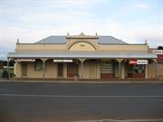
26 Veal St Hopetoun
Shops - Metropole Hotel
Starboard Cafe & Nautilus Restaurant
Ravensthorpe
Goldfields
Constructed from 1901 to 1907
| Type | Status | Date | Documents |
|---|---|---|---|
| State Register | Registered | 20 Feb 2004 | HCWebsite.Listing+ListingDocument, HCWebsite.Listing+ListingDocument |
| Type | Status | Date | Documents |
|---|---|---|---|
| (no listings) |
| Type | Status | Date | Grading/Management | |
|---|---|---|---|---|
| Category | ||||
| Municipal Inventory | Adopted | 10 Jul 1998 | ||
| Statewide Hotel Survey | Completed | 01 Nov 1997 | ||
Good
| Name | Type | Year From | Year To |
|---|---|---|---|
| JS Black | Architect | - | - |
Individual Building or Group
| Epoch | General | Specific |
|---|---|---|
| Present Use | SOCIAL\RECREATIONAL | Other |
| Present Use | VACANT\UNUSED | Vacant\Unused |
| Original Use | COMMERCIAL | Shop\Retail Store {single} |
| Other Use | INDUSTRIAL\MANUFACTURING | Other |
| Original Use | COMMERCIAL | Hotel, Tavern or Inn |
| Style |
|---|
| Federation Free Style |
| Federation Bungalow |
| Type | General | Specific |
|---|---|---|
| Roof | METAL | Corrugated Iron |
| Wall | BRICK | Rendered Brick |
| Wall | TIMBER | Slab |
| Wall | BRICK | Handmade Brick |
| General | Specific |
|---|---|
| OCCUPATIONS | Hospitality industry & tourism |
This information is provided voluntarily as a public service. The information provided is made available in good faith and is derived from sources believed to be reliable and accurate. However, the information is provided solely on the basis that readers will be responsible for making their own assessment of the matters discussed herein and are advised to verify all relevant representations, statements and information.
Constructed from 1900, Constructed from 1907
In 1925 the hotel was delicensed and turned into holiday flats. The building is still in use today as a cafe and restaurant.
Built in 1900 by J.S.Back for Mr and Mrs Sinclair. Sold to Mr and Mrs Hiller who did a brick reconstruction in 1907.
Integrity: Mostly Intact
Good
| Name | Type | Year From | Year To |
|---|---|---|---|
| JS Black | Architect | - | - |
This information is provided voluntarily as a public service. The information provided is made available in good faith and is derived from sources believed to be reliable and accurate. However, the information is provided solely on the basis that readers will be responsible for making their own assessment of the matters discussed herein and are advised to verify all relevant representations, statements and information.
87 Veal St Hopetoun
Ravensthorpe
Goldfields
Constructed from 1909
| Type | Status | Date | Documents |
|---|---|---|---|
| (no listings) |
| Type | Status | Date | Documents |
|---|---|---|---|
| (no listings) |
| Type | Status | Date | Grading/Management | |
|---|---|---|---|---|
| Category | ||||
| Municipal Inventory | Adopted | 10 Jul 1998 | ||
Historic Site
| Epoch | General | Specific |
|---|---|---|
| Present Use | COMMERCIAL | Shop\Retail Store {single} |
| Original Use | COMMERCIAL | Shop\Retail Store {single} |
| Present Use | Transport\Communications | Comms: Post or Telegraph Office |
| General | Specific |
|---|---|
| OCCUPATIONS | Commercial & service industries |
This information is provided voluntarily as a public service. The information provided is made available in good faith and is derived from sources believed to be reliable and accurate. However, the information is provided solely on the basis that readers will be responsible for making their own assessment of the matters discussed herein and are advised to verify all relevant representations, statements and information.
Constructed from 1909
Built in 1909 by Mr and Mrs Tom Veal who claimed to be the first residents in Hopetoun. Tile Post Office was transferred to the store from Post Office and Telegraph Office across the road in the early 1970s. The original siore was demolished in 1988 and a new store now occupies the site.
Integrity: None
Site
| Name | Type | Year From | Year To |
|---|---|---|---|
| Tom Veal | Architect | 1909 | - |
This information is provided voluntarily as a public service. The information provided is made available in good faith and is derived from sources believed to be reliable and accurate. However, the information is provided solely on the basis that readers will be responsible for making their own assessment of the matters discussed herein and are advised to verify all relevant representations, statements and information.
Jerdacuttup
Ravensthorpe
Goldfields
Constructed from 1964
| Type | Status | Date | Documents |
|---|---|---|---|
| (no listings) |
| Type | Status | Date | Documents |
|---|---|---|---|
| (no listings) |
| Type | Status | Date | Grading/Management | |
|---|---|---|---|---|
| Category | ||||
| Municipal Inventory | Adopted | 10 Jul 1998 | ||
Individual Building or Group
| Epoch | General | Specific |
|---|---|---|
| Other Use | SOCIAL\RECREATIONAL | Other Community Hall\Centre |
| Present Use | EDUCATIONAL | Primary School |
| Original Use | EDUCATIONAL | Primary School |
| Type | General | Specific |
|---|---|---|
| Roof | METAL | Corrugated Iron |
| Other | CONCRETE | Concrete Slab |
| Wall | STONE | Local Stone |
| General | Specific |
|---|---|
| SOCIAL & CIVIC ACTIVITIES | Education & science |
This information is provided voluntarily as a public service. The information provided is made available in good faith and is derived from sources believed to be reliable and accurate. However, the information is provided solely on the basis that readers will be responsible for making their own assessment of the matters discussed herein and are advised to verify all relevant representations, statements and information.
Constructed from 1987, Constructed from 1964
Jerdacuttup s first school was opened in 1962 with 8 pupils. It was built in 1964 by settler families Challinger, Dow, Hall and Knight-Smith on Mr Mitchell Chaney's property. It was used as a school for eighteen months until an Education Department school was built in 1966 on Jerdacuttup townsite. Following this it was used for meetings and church services for several more years and then fell into a poor stale of repair. In 1987 the building was dismantled and rebuilt close to the present school. This was funded by a Federal bicentenary grant applied for by the P&C. A plaque has been placed at the original site.
The building has a concrete floor. Ravensthorpe Stone walls and corrugated iron roof. The one room structure was 12ft x 18ft with three small louvre windows, one wooden door, corrugated iron verandah partially enclosed on the north side, a 600 gallon galvanised water tank and pan toilets. The head teacher. John Wilkins lived in a caravan close by outside the farm boundary fence.
Integrity: A concrete base remains
This information is provided voluntarily as a public service. The information provided is made available in good faith and is derived from sources believed to be reliable and accurate. However, the information is provided solely on the basis that readers will be responsible for making their own assessment of the matters discussed herein and are advised to verify all relevant representations, statements and information.
Burlabup Creek Jerdacuttup
Ravensthorpe
Goldfields
Constructed from 1928
| Type | Status | Date | Documents |
|---|---|---|---|
| (no listings) |
| Type | Status | Date | Documents |
|---|---|---|---|
| (no listings) |
| Type | Status | Date | Grading/Management | |
|---|---|---|---|---|
| Category | ||||
| Municipal Inventory | Adopted | 10 Jul 1998 | ||
Poor
| Name | Type | Year From | Year To |
|---|---|---|---|
| H Horner | Architect | - | - |
Historic Site
| Epoch | General | Specific |
|---|---|---|
| Original Use | FARMING\PASTORAL | Other |
| Present Use | OTHER | Other |
| Type | General | Specific |
|---|---|---|
| Wall | METAL | Corrugated Iron |
| Wall | TIMBER | Other Timber |
| General | Specific |
|---|---|
| DEMOGRAPHIC SETTLEMENT & MOBILITY | Settlements |
This information is provided voluntarily as a public service. The information provided is made available in good faith and is derived from sources believed to be reliable and accurate. However, the information is provided solely on the basis that readers will be responsible for making their own assessment of the matters discussed herein and are advised to verify all relevant representations, statements and information.
Constructed from 1928
Johnny Horner (1874-1961) was born at Riverton, South Australia and he came to WA at the turn of the century. An ex German prisoner of war from WWI, he had been developing a new land block at Wagin and he sold up there and came to join friends Ernie Bennett and family of Springdale. At 54 he searched through the bush to find a suitable squatter spot and decided upon Ihe Burlabup Creek near the Jerdacuttup River. Johnny Horner, a God fearing man, lived at the camp as a hermit, naturalist and astronomer from 1928 - 1950 until he was removed to Lake Grace hospital suffering from malnutrition. For a short while he lived with Ernie Bennett (Who had returned to Lake Grace) before dying in die Lake Grace Hospital and was buried there in 1961. Horner is regarded as the pioneer who opened up Jerdacuttup. The site is fenced off and there remains two hand built dams, fruit trees, fencing and stone built creek crossing.
Johnny Homer cut a 20km track by mattock from Kundip to his camp wide enough to drive his model A Ford. The road is now part of the Jerdacuttup North Road. He built a two room corrugated iron homestead, grew vegetables and fruit for sale and barter and sold honey. Many of the fruit trees are still remaining but some removed to a neighbouring farm, Woodstock, unfortunately died.
Integrity: 2 hand built dams, fruit trees, fencing and stone built creek crossing.
Poor
| Owner | Category |
|---|---|
| Woodstock Nominees | Other Private |
This information is provided voluntarily as a public service. The information provided is made available in good faith and is derived from sources believed to be reliable and accurate. However, the information is provided solely on the basis that readers will be responsible for making their own assessment of the matters discussed herein and are advised to verify all relevant representations, statements and information.
Cnr Fence Rd & Hwy One Jerdacuttup
Junction of Fence Road and Hwy One
Ravensthorpe
Goldfields
| Type | Status | Date | Documents |
|---|---|---|---|
| (no listings) |
| Type | Status | Date | Documents |
|---|---|---|---|
| (no listings) |
| Type | Status | Date | Grading/Management | |
|---|---|---|---|---|
| Category | ||||
| Municipal Inventory | Adopted | 10 Jul 1998 | ||
Cover stone removed and broken
| Name | Type | Year From | Year To |
|---|---|---|---|
| Aborigines | Architect | - | - |
Historic Site
| Epoch | General | Specific |
|---|---|---|
| Original Use | OTHER | Other |
| Present Use | OTHER | Other |
| General | Specific |
|---|---|
| DEMOGRAPHIC SETTLEMENT & MOBILITY | Aboriginal Occupation |
This information is provided voluntarily as a public service. The information provided is made available in good faith and is derived from sources believed to be reliable and accurate. However, the information is provided solely on the basis that readers will be responsible for making their own assessment of the matters discussed herein and are advised to verify all relevant representations, statements and information.
A good example of a Gnamma Hole. Not permanent water in very dry years,
Situated on the corner of Highway One and Fence Road, Jerdacuttup. There are more Gnamma Holes south along Gnamma Creek on Oldfield Loc 775.
Integrity: Cover stone removed and broken.
| Name | Type | Year From | Year To |
|---|---|---|---|
| Aborigines | Architect | - | - |
| Owner | Category |
|---|---|
| Agricultural Protection Board | State Gov't |
This information is provided voluntarily as a public service. The information provided is made available in good faith and is derived from sources believed to be reliable and accurate. However, the information is provided solely on the basis that readers will be responsible for making their own assessment of the matters discussed herein and are advised to verify all relevant representations, statements and information.
Jerdacuttup River Jerdacuttup
Ravensthorpe
Goldfields
| Type | Status | Date | Documents |
|---|---|---|---|
| (no listings) |
| Type | Status | Date | Documents |
|---|---|---|---|
| (no listings) |
| Type | Status | Date | Grading/Management | |
|---|---|---|---|---|
| Category | ||||
| Municipal Inventory | Adopted | 10 Jul 1998 | ||
Historic Site
| Epoch | General | Specific |
|---|---|---|
| Original Use | OTHER | Other |
| Present Use | OTHER | Other |
| General | Specific |
|---|---|
| DEMOGRAPHIC SETTLEMENT & MOBILITY | Settlements |
This information is provided voluntarily as a public service. The information provided is made available in good faith and is derived from sources believed to be reliable and accurate. However, the information is provided solely on the basis that readers will be responsible for making their own assessment of the matters discussed herein and are advised to verify all relevant representations, statements and information.
The aboriginal name meaning "to the head of the bird" was originally applied by John Forrest in 1870.
The Dunn Brothers were marooned on the coast whilst sealing and found this fresh water spring. In 1870 the Dunn Brothers sat with Sir John and Alexander Forrest (when they were surveying in reverse a similar route taken by John Edward Eyre in 1841 for the East West Telegraph Line) at the spring before (hey continued east.
Integrity: Intact
This information is provided voluntarily as a public service. The information provided is made available in good faith and is derived from sources believed to be reliable and accurate. However, the information is provided solely on the basis that readers will be responsible for making their own assessment of the matters discussed herein and are advised to verify all relevant representations, statements and information.
658 Springdale Rd Jerdacuttup
Oldfield Location 1447
Ravensthorpe
Goldfields
Constructed from 1904
| Type | Status | Date | Documents |
|---|---|---|---|
| (no listings) |
| Type | Status | Date | Documents |
|---|---|---|---|
| (no listings) |
| Type | Status | Date | Grading/Management | |
|---|---|---|---|---|
| Category | ||||
| Municipal Inventory | Adopted | 10 Jul 1998 | ||
Sound
| Name | Type | Year From | Year To |
|---|---|---|---|
| Thomas Veal | Architect | - | - |
Individual Building or Group
| Epoch | General | Specific |
|---|---|---|
| Present Use | FARMING\PASTORAL | Homestead |
| Original Use | FARMING\PASTORAL | Homestead |
| Type | General | Specific |
|---|---|---|
| Wall | METAL | Corrugated Iron |
| Roof | METAL | Corrugated Iron |
| General | Specific |
|---|---|
| OCCUPATIONS | Rural industry & market gardening |
This information is provided voluntarily as a public service. The information provided is made available in good faith and is derived from sources believed to be reliable and accurate. However, the information is provided solely on the basis that readers will be responsible for making their own assessment of the matters discussed herein and are advised to verify all relevant representations, statements and information.
Constructed from 1904
The Springdale Homestead was Miner's Homestead Lease No I of 112 acres. It was taken up bv Alec McDonaldand John Purchas in April 190! and refused on 9 September 1903. The lease was then re-allocated to Thomas Veal of Hopetoun as MHL No 25 "Springdale" in 1904. He grew fruit, vegetables and trees, fully irrigated. From October 1908 fresh fruil and vegetables were supplied three times weekly from the market gardens of Nicholas and Hams. (Phillips River Times). The property has changed hands many times. In about 1920 Leiper Bros and Birchley, Ravensihorpe butchers owned it and from 1927-30 Ernie Bennett of Lake Grace bought il. It then passed in to his daughter Rita (married Tommy Daw) in about 1940. then her son Murray Daw and il is now owned by Mary Richardson as Oldfield Local ion 1447 of 190 acres. The homestead was purchased by her in 1987.
The homestead is constructed with salt water paperbark framework with corrugated iron walls and roof. There are four small rooms in the homestead. Sheep dip and a corrugated iron shed close by. The wool shed, cow shed and salt water paperbark sheep yards were destroyed by fire in 1994.
Integrity: All of house and shed
Good
This information is provided voluntarily as a public service. The information provided is made available in good faith and is derived from sources believed to be reliable and accurate. However, the information is provided solely on the basis that readers will be responsible for making their own assessment of the matters discussed herein and are advised to verify all relevant representations, statements and information.