Local Government
Rockingham
Region
Metropolitan
Rockingham
Metropolitan
| Type | Status | Date | Documents |
|---|---|---|---|
| (no listings) |
| Type | Status | Date | Documents |
|---|---|---|---|
| RHP - Does not warrant assessment | Current | 14 May 2021 |
| Type | Status | Date | Grading/Management | |
|---|---|---|---|---|
| Category | ||||
| (no listings) | ||||
The place comprises a timber bridge across the Serpentine River.
The bridge is believed to have been constructed during the period this site was known as Amarillo Farm to facilitate access to the other side of the property.
Poor
Other Built Type
| Epoch | General | Specific |
|---|---|---|
| Original Use | Transport\Communications | Road: Bridge |
| Type | General | Specific |
|---|---|---|
| Other | TIMBER | Other Timber |
| General | Specific |
|---|---|
| TRANSPORT & COMMUNICATIONS | Road transport |
This information is provided voluntarily as a public service. The information provided is made available in good faith and is derived from sources believed to be reliable and accurate. However, the information is provided solely on the basis that readers will be responsible for making their own assessment of the matters discussed herein and are advised to verify all relevant representations, statements and information.
Murray Reefs 3km West of Port Kennedy/Warnbro Sound
Rockingham
Metropolitan
| Type | Status | Date | Documents |
|---|---|---|---|
| (no listings) |
| Type | Status | Date | Documents |
|---|---|---|---|
| (no listings) |
| Type | Status | Date | Grading/Management | |
|---|---|---|---|---|
| Category | ||||
| Register of the National Estate | Registered | 21 Oct 1978 | ||
Historic Site
| Epoch | General | Specific |
|---|---|---|
| Original Use | Transport\Communications | Water: Other |
| General | Specific |
|---|---|
| TRANSPORT & COMMUNICATIONS | River & sea transport |
This information is provided voluntarily as a public service. The information provided is made available in good faith and is derived from sources believed to be reliable and accurate. However, the information is provided solely on the basis that readers will be responsible for making their own assessment of the matters discussed herein and are advised to verify all relevant representations, statements and information.
Baldivis & Karnup Rds surrounds Baldivis
Rockingham
Metropolitan
| Type | Status | Date | Documents |
|---|---|---|---|
| (no listings) |
| Type | Status | Date | Documents |
|---|---|---|---|
| (no listings) |
| Type | Status | Date | Grading/Management | |
|---|---|---|---|---|
| Category | ||||
| (no listings) | ||||
Urban Open Space
| Epoch | General | Specific |
|---|---|---|
| Present Use | PARK\RESERVE | Park\Reserve |
This information is provided voluntarily as a public service. The information provided is made available in good faith and is derived from sources believed to be reliable and accurate. However, the information is provided solely on the basis that readers will be responsible for making their own assessment of the matters discussed herein and are advised to verify all relevant representations, statements and information.
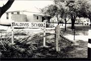
342 Baldivis Rd Baldivis
Corner of Fifty and Baldivis Rd. Reserve 23952, Lot 1376 on Plan 190710.
Baldivis Play Group
Day Centre & Art Centre
Rockingham
Metropolitan
Constructed from 1923 to 1924
| Type | Status | Date | Documents |
|---|---|---|---|
| Heritage List | Adopted | 24 Apr 2018 |
| Type | Status | Date | Documents |
|---|---|---|---|
| RHP - To be assessed | Current | 30 Oct 2009 |
| Type | Status | Date | Grading/Management | |
|---|---|---|---|---|
| Category | ||||
| Municipal Inventory | Adopted | 24 Apr 2018 | Category A | |
· The place is a rare example in the metropolitan area of a school from this period consisting entirely of weatherboard.
· The place is rare example in the metropolitan area of a weatherboard school surviving intact on its original site.
· The place is a rare example of a surviving Group Settlement School.
· The place is rare as the only surviving example of a Group Settlement School located in the metropolitan area.
· The place has historic value as part of the Group Settlement Scheme associated with the Peel Region, which was the only Group Settlement region close in proximity to Perth, the others being located in the South-West of Western Australia.
· The place has a strong identity in the community who are aware and proud of its history and its contribution to rural students of the area, past and present.
The Primary School comprises two buildings: the original Baldivis Primary school, and the re-located School 39 building. There is no mention in the MI of the original location of School 39. The MI states “A pair of single-story one-roomed weatherboard buildings with corrugated iron gable roofs and timber-framed skillion verandas to the front (east) and rear (west) elevations. The buildings feature regularly spaced, vertically proportioned timber-framed windows, each of which is fitted with a fixed metal awning. Both buildings also feature small corrugated iron rainwater tanks (located on the east elevation) and timber ramps to the verandah.
The Group Settlement Scheme was responsible for the establishment of groups on the Peel Estate from 1922. The Principal’s Pen states, “The school opened on the 4th of February 1924 meeting the educational needs of two settlement groups, 50 and 54, that surrounded the school site.” The school was named Group 50-54 school, but in 1926 the P&C was formed and the school was renamed Baldivis after the three ships that had brought the group settlers to Western Australia. The children had to walk to and from school on dirt tracks many of which, after waking early, had to participate in chores in the dairies and farms of the settlements.
| Library Id | Title | Medium | Year Of Publication |
|---|---|---|---|
| 9910 | Baldivis Primary School (fmr) 342 Baldivis Road, Baldivis WA | Electronic | 2011 |
Individual Building or Group
| Epoch | General | Specific |
|---|---|---|
| Original Use | EDUCATIONAL | Primary School |
| Present Use | EDUCATIONAL | Other |
| Type | General | Specific |
|---|---|---|
| Wall | TIMBER | Weatherboard |
| Roof | METAL | Corrugated Iron |
| General | Specific |
|---|---|
| DEMOGRAPHIC SETTLEMENT & MOBILITY | Immigration, emigration & refugees |
| SOCIAL & CIVIC ACTIVITIES | Education & science |
| DEMOGRAPHIC SETTLEMENT & MOBILITY | Settlements |
This information is provided voluntarily as a public service. The information provided is made available in good faith and is derived from sources believed to be reliable and accurate. However, the information is provided solely on the basis that readers will be responsible for making their own assessment of the matters discussed herein and are advised to verify all relevant representations, statements and information.
Constructed from 1924, Constructed from 1923
The place has aesthetic value as a modest weatherboard and iron school building in the Inter War style. It is representative of the one room school type designed and built by the PWD during this period. The place has historic value for its association with the Group Settlements established on the Peel Estate from 1922. The place is a rare remaining example of the group settlement schools in the region. The place has social value for the many members of the community who have attended the school or the play group at the location.
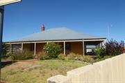
A pair of timber framed and iron former classrooms located on the edge of the Baldivis Reserve and overlooking Baldivis Road. The two buildings are similar in their execution, both one room structures with front and rear additions. The external walls are clad with fibre cement sheeting and weatherboard cladding to the east elevations. Windows to both are 6-over- timber framed sashes, with awnings to the openings on the north elevations. The northernmost building has four windows to the north and south elevation whilst the second building has three openings to the north and south elevations. Both buildings are accessed by ramped timber veranda’s with skillion canopies. The rear additions have skillion roofs and are a combination of enclosed and open spaces extending across the full width of the building. A commemorative rock and plaque has been placed within the grounds commemorating the memory of the pioneers of the district, 1923. The buildings are located approximately 50m apart, forming a central grass quadrangle between them. There are several mature peppermint trees (Agonis flexuosa) surrounding the buildings, particularly along Baldivis Road. A number of secondary buildings are also located around the site.
These two school buildings were built during the time that Group Settlements were established on the Peel Estate, from 1922. A total of four schools were built; the first at Baldivis (Group 50-54), followed by those at Karnup, Wellard and Group 81. The first application for a school was made in July 1923 by the settlers on Group 50 and 54. It was completed on 20 October 1923, and opened in February of the following year. The school buildings were of the standard one-roomed country type designed and built by the Public Works Department. The classroom was constructed so that the room could be divided if required. At first this school site was known as Group 50-54 School, but in June 1926 its name was changed to Baldivis, as by that time, Group 54 was served by the Wellard School. The Group Settlement population of school-age children declined in the 1930s. The Group 81 School closed around 1936; the Karnup School around 1940; and the Wellard School closed in 1947-48. By 1950, only the Baldivis School remained and its population was increasing. In 1950, a new shelter shed was built. In 1953, the school population was 52. In 1954, the former Group 39 School was removed and re-erected at the Baldivis Reserve adjacent to the Baldivis School building. The Baldivis Primary School operated from this site until 1978. In 1978, a new brick building was constructed west of the original school site on the site of the current Baldivis Primary School. The primary school has been operating from that site since then and grown and developed in response to the growing population. The two original school buildings have continued to be used and are currently [2017] occupied by the Baldivis Play Group.
Integrity: High Degree Authenticity: High Degree
Good
| Ref ID No | Ref Name | Ref Source | Ref Date |
|---|---|---|---|
| Place Records | City of Rockingham MHI | ||
| Aerial Photos | Landgate | ||
| Baldivis Primary School Conservation Plan 2011 |
| Reserve | Lot/Location | Plan/Diagram | Vol/Folio |
|---|---|---|---|
| R23952 | 1376 | 190710 |
| Owner | Category |
|---|---|
| City of Rockingham | Local Gov't |
This information is provided voluntarily as a public service. The information provided is made available in good faith and is derived from sources believed to be reliable and accurate. However, the information is provided solely on the basis that readers will be responsible for making their own assessment of the matters discussed herein and are advised to verify all relevant representations, statements and information.
342 Baldivis Rd Baldivis
Rockingham
Metropolitan
| Type | Status | Date | Documents |
|---|---|---|---|
| Heritage List | Adopted | 24 Apr 2018 |
| Type | Status | Date | Documents |
|---|---|---|---|
| (no listings) |
| Type | Status | Date | Grading/Management | |
|---|---|---|---|---|
| Category | ||||
| (no listings) | ||||
Urban Open Space
| Epoch | General | Specific |
|---|---|---|
| Present Use | PARK\RESERVE | Park\Reserve |
| Original Use | PARK\RESERVE | Park\Reserve |
This information is provided voluntarily as a public service. The information provided is made available in good faith and is derived from sources believed to be reliable and accurate. However, the information is provided solely on the basis that readers will be responsible for making their own assessment of the matters discussed herein and are advised to verify all relevant representations, statements and information.
This information is provided voluntarily as a public service. The information provided is made available in good faith and is derived from sources believed to be reliable and accurate. However, the information is provided solely on the basis that readers will be responsible for making their own assessment of the matters discussed herein and are advised to verify all relevant representations, statements and information.
118 Fifty Rd Baldivis
Lot 100 on Diagram 091349
Rockingham
Metropolitan
Constructed from 1920
| Type | Status | Date | Documents |
|---|---|---|---|
| Heritage List | Adopted | 01 Mar 2008 |
| Type | Status | Date | Documents |
|---|---|---|---|
| (no listings) |
| Type | Status | Date | Grading/Management | |
|---|---|---|---|---|
| Category | ||||
| Municipal Inventory | Adopted | 24 Apr 2018 | Category C | |
Individual Building or Group
| Epoch | General | Specific |
|---|---|---|
| Original Use | RESIDENTIAL | Single storey residence |
| Present Use | RESIDENTIAL | Single storey residence |
This information is provided voluntarily as a public service. The information provided is made available in good faith and is derived from sources believed to be reliable and accurate. However, the information is provided solely on the basis that readers will be responsible for making their own assessment of the matters discussed herein and are advised to verify all relevant representations, statements and information.

Constructed from 1920
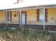
• The place has aesthetic value as a demonstration of a simple vernacular timber cottage still located in its original setting. • The place has historic value for its association with the Peel Estate Group Settlement Scheme and with the Pugh family who settled in the district in the 1920s.
Group Settler’s Home comprises a single-storey weatherboard residence, set within a large site with mature trees and shrubs to its surroundings. The building is set back from the main road with its entry via a driveway located along Fifty Road. The building has a simple rectilinear form with a metal clad gable roof and verandah extending across northwest and southeast elevations. The windows on the north west elevation are timber-framed shaded by timber awnings. Additional windows were inserted into the south east elevation following the removal of the fireplaces and chimneys. The front elevation is oriented southeast, where the original entrance from the street was located. The façade is symmetrical in plan form with a centrally placed entrance flanked by windows and protected by a partially enclosed timber-framed verandah. The building has a rear entry door located at the northwest elevation, facing the garden with extensive grassed area and plantings. The roof is predominantly a gable form, sweeping down to incorporate the front and rear verandah/additions. The rear elevation also contains a skillion roof section which is a later addition incorporating the rear access and laundry. The windows to the front elevation are side hung casements with horizontal glazing bars dividing each pane into three sections. Many of the windows have been replaced with aluminium openings.
In the 1920s, David Hammer Pugh (1900-1992) and Olga Petrovna Pugh (1902-1972) lived at Location 131 on Group 66 of the Peel Estate Group Settlement Scheme. In 1933, the Pughs purchased more land to expand their property holdings, and subsequently moved to an original settler’s four-roomed cottage in Fifty Road. Dave Pugh recorded his occupation as a dairyman and labourer throughout his life and Olga undertook home duties. The homes built for the Group Settlers were generally simple cottages either built by the settlers themselves or simple standard timber cottages designed by the Public Works Department. The origin of this cottage design or builder is not known. Following Olga's death in 1972, Dave Pugh lived there until his death in 1992. The out-buildings on this property are still extant. The building was renovated, refurbished and extended in 1993, including replacement of weatherboard claddings to both northeast and southwest exterior walls. Additions were made to the rear of the building (northwest) enclosing the former verandah.
Integrity: High Authenticity: Moderate
Good
| Reserve | Lot/Location | Plan/Diagram | Vol/Folio |
|---|---|---|---|
| 100 | 91349 |
| Owner | Category |
|---|---|
| O Pugh | Other Private |
This information is provided voluntarily as a public service. The information provided is made available in good faith and is derived from sources believed to be reliable and accurate. However, the information is provided solely on the basis that readers will be responsible for making their own assessment of the matters discussed herein and are advised to verify all relevant representations, statements and information.
Chesterfield Rd East Rockingham
Rockingham
Metropolitan
Constructed from 1850, Constructed from 1950
| Type | Status | Date | Documents |
|---|---|---|---|
| Heritage List | Adopted | 01 Sep 2012 |
| Type | Status | Date | Documents |
|---|---|---|---|
| RHP - To be assessed | Current | 19 Apr 2013 |
| Type | Status | Date | Grading/Management | |
|---|---|---|---|---|
| Category | ||||
| Municipal Inventory | Adopted | 24 Apr 2018 | Category A | |
03841 East Rockingham Heritage Precinct
Obscured by vegetation but likely contains other intact evidence for quarrying activities
Historic site
| Epoch | General | Specific |
|---|---|---|
| Present Use | VACANT\UNUSED | Vacant\Unused |
| Original Use | INDUSTRIAL\MANUFACTURING | Other |
| Type | General | Specific |
|---|---|---|
| Other | STONE | Limestone |
| General | Specific |
|---|---|
| DEMOGRAPHIC SETTLEMENT & MOBILITY | Resource exploitation & depletion |
| DEMOGRAPHIC SETTLEMENT & MOBILITY | Settlements |
| PEOPLE | Early settlers |
This information is provided voluntarily as a public service. The information provided is made available in good faith and is derived from sources believed to be reliable and accurate. However, the information is provided solely on the basis that readers will be responsible for making their own assessment of the matters discussed herein and are advised to verify all relevant representations, statements and information.
Constructed from 1850, Constructed from 1950
Construction - Mid 1800s •The place has historic value as a source of a rare building material within the state and appears to be localised to the East Rockingham area with many of the older houses being constructed from the stone. •The place has social value for its association with the early settlers in the area and demonstrates the tough physical conditions faced in the construction of the first substantial homes. •The place has research value as the material sourced from this quarry is a localised stone with unique characteristics which could provide valuable information for students of geology. •The place has research value as the techniques used to extract the stone were employed at this site until the 1950s and the remains in the landscape may reveal information on the methods of quarrying used in the 19th and early 20th century.
The limestone quarry lies within an ecological conservation area off Mandurah Road within East Rockingham. The site is inland and cannot be seen from the main road, being accessed via a sandy track known as Chesterfield Road. The area has become bushland following the cessation of quarrying which obscures much of the evidence of the quarry. Small areas of rocky outcrops are scattered through the site. The main evidence of the quarry is a crusted edge of approximately 300mm in a clearing which shows evidence of stone being cut leaving a stepped or jagged edge. The limestone is known as a vuggy lacustrine limestone, more commonly known as swampstone, coral stone or honeycomb limestone. The term ‘vuggy’ refers to the network of chambers that creates the honeycomb appearance. It is a softer material that tends to harden with exposure to air.
This quarry is believed to be the source of building materials for local buildings constructed in the mid-19th century. It is probable that given the proximity of Chesterfield House that this quarry was the source of the stone for that building. Little direct documentary evidence has been found, however, to substantiate direct linkages between this quarry and the adjacent properties ‘Chesterfield House’, ‘Woodbine’, ‘Hymus House’ and ‘Leaholm’ amongst others. James Bell who built his own cottage ‘Woodbine’ is believed to have built ‘Chesterfield House’ and he may have quarried the stone himself from the quarry.
Condition - Poor
Integrity: High Authenticity: High
Poor
| Ref ID No | Ref Name | Ref Source | Ref Date |
|---|---|---|---|
| Aerial Photographs | Landgate | 1953-2012 | |
| "Chesterfield House, Chesterfield Road, East Rockingham, Conservation Plan for the City of Rockingham". p.19 | City of Rockingham | November 1999 | |
| Palassis Architects; "City of Rockingham Municipal Heritage Inventory, Thematic Framework and Historical Overview". p.15 | City of Rockingham | 2011 |
| Reserve | Lot/Location | Plan/Diagram | Vol/Folio |
|---|---|---|---|
| R52979 | 9003 | 48637 |
This information is provided voluntarily as a public service. The information provided is made available in good faith and is derived from sources believed to be reliable and accurate. However, the information is provided solely on the basis that readers will be responsible for making their own assessment of the matters discussed herein and are advised to verify all relevant representations, statements and information.
2 Lodge Dr East Rockingham
Off Day Road, Nearest cross street Mandurah Road Main deposit is around a swamp off Day Rd
Rockingham
Metropolitan
| Type | Status | Date | Documents |
|---|---|---|---|
| (no listings) |
| Type | Status | Date | Documents |
|---|---|---|---|
| (no listings) |
| Type | Status | Date | Grading/Management | |
|---|---|---|---|---|
| Category | ||||
| (no listings) | ||||
Historic Site
| Epoch | General | Specific |
|---|---|---|
| Present Use | INDUSTRIAL\MANUFACTURING | Other |
| Original Use | INDUSTRIAL\MANUFACTURING | Other |
This information is provided voluntarily as a public service. The information provided is made available in good faith and is derived from sources believed to be reliable and accurate. However, the information is provided solely on the basis that readers will be responsible for making their own assessment of the matters discussed herein and are advised to verify all relevant representations, statements and information.
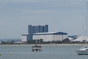
Lot 1304 & 1585 Rockingham Beach Rd East Rockingham
Lots 1304 and 1585 on Plans 173579 and 191087
Rockingham
Metropolitan
Constructed from 1969 to 1975
| Type | Status | Date | Documents |
|---|---|---|---|
| Heritage List | Adopted | 01 Mar 2008 |
| Type | Status | Date | Documents |
|---|---|---|---|
| (no listings) |
| Type | Status | Date | Grading/Management | |
|---|---|---|---|---|
| Category | ||||
| Municipal Inventory | Adopted | 25 Mar 2008 | Category B | |
Individual Building or Group
| Epoch | General | Specific |
|---|---|---|
| Original Use | INDUSTRIAL\MANUFACTURING | Silo\Grain Shed |
| Original Use | Transport\Communications | Water: Jetty |
| Type | General | Specific |
|---|---|---|
| Wall | CONCRETE | Concrete Block |
This information is provided voluntarily as a public service. The information provided is made available in good faith and is derived from sources believed to be reliable and accurate. However, the information is provided solely on the basis that readers will be responsible for making their own assessment of the matters discussed herein and are advised to verify all relevant representations, statements and information.
Constructed from 1975, Constructed from 1969
• The grain terminal and jetty have aesthetic value as a landmark in the district for its bold colouring, large monolithic structure and location in a predominantly flat landscape. • The grain terminal and jetty have historic value for their association with the development of the industrial complex in the late 1960s and early 1970s which was fostered by the state government and implemented by private companies.
Substantial complex that has become part of the Rockingham/Kwinana foreshore and a landmark for the area. The complex consists of vertical grain silos, the two horizontal storage units to the rear of the site, the shipping gallery and jetty across Rockingham Beach Road and the Museum building. The jetty/shipping gallery is located a distance from silo but connected via a long enclosed jetty that extends under the road to the main silo building. The jetty is 752m long with the shipping gallery being 291m. The vertical silo building consists of two ranges of silos, separated by a 12 storey building known as the ‘Workhouse’. The grain travels along the jetty on the shipping conveyors before unloading onto the waiting ships via the four ship loaders. The silos are constructed from reinforced concrete. The Museum is housed in a simple brick building located to the front of the silos.
The Kwinana Grain Terminal and jetty are part of the industrial complex that was developed through partnerships of state and private investment in the 1950s and 1960s. The advantages of Cockburn Sound as a deep water port in contrast to Fremantle port, the availability of land and rail access led to the decision to develop the small settlement of Kwinana as an industrial complex. The need for a larger grain terminal was recognised in the mid-1960s as Western Australia’s grain production increased. Although the facilities at Fremantle had been enlarged the site was limited and the port could not be deepened for the ever increasing size of the bulk carriers. Co-operative Bulk Handling Limited which handles the state's grain crop secured the finance to build the terminal and works began in 1969. The first shipment of grain was loaded in that year and the terminal was completed in 1975. The site chosen for the terminal is on the landward side of Rockingham Road to enable access to the beach is still possible. The series of massive storage cells are used for the cleaning, sorting, weighing and storage of most of the grain crop in Western Australia. The grains are then loaded onto the elevators, or transfer galleries, for loading onto the bulk carriers. The galleries are located under Rockingham Road and part of the beach before rising up above sea level for loading onto the ships. The jetty is over 300 meters long and carries the galleries to three loading berths located on a jetty running parallel to the shore. All of the operations are controlled from a central control room within a control tower. The granary museum was established on the site in the early 1990s and is open periodically to the public. It tells the history of grain production in Western Australia and has been revised in 2011 to include interactive displays.
Integrity: High Authenticity: High
Good
| Reserve | Lot/Location | Plan/Diagram | Vol/Folio |
|---|---|---|---|
| 1304 | 173579 | ||
| 1585 | 191087 |
| Owner | Category |
|---|---|
| Co-operative Bulk Handlling | Other Private |
This information is provided voluntarily as a public service. The information provided is made available in good faith and is derived from sources believed to be reliable and accurate. However, the information is provided solely on the basis that readers will be responsible for making their own assessment of the matters discussed herein and are advised to verify all relevant representations, statements and information.
231 Mandurah Rd East Rockingham
Lot 3095 on Plan 190473
Rockingham
Metropolitan
Constructed from 1842
| Type | Status | Date | Documents |
|---|---|---|---|
| Heritage List | Adopted | 01 Mar 2008 |
| Type | Status | Date | Documents |
|---|---|---|---|
| RHP - To be assessed | Current | 19 Apr 2013 |
| Type | Status | Date | Grading/Management | |
|---|---|---|---|---|
| Category | ||||
| Municipal Inventory | Adopted | 24 Apr 2018 | Category A | |
03841 East Rockingham Heritage Precinct
Historic Site
| Epoch | General | Specific |
|---|---|---|
| Present Use | MONUMENT\CEMETERY | Cemetery |
This information is provided voluntarily as a public service. The information provided is made available in good faith and is derived from sources believed to be reliable and accurate. However, the information is provided solely on the basis that readers will be responsible for making their own assessment of the matters discussed herein and are advised to verify all relevant representations, statements and information.
Constructed from 1842
• The place has aesthetic value for the variety of monuments and fixtures, which display skills and craftsmanship in the disciplines of ironwork and stone masonry. • The place is a distinct landmark on Mandurah Road featuring a number of prominent tree plantings along its road edge. • The place has historic value for its association with the European settlement of the area and provides a record of the development and growth in the region. • The place is associated with individuals and families connected with the history of Rockingham and the development of the town and region.
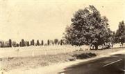
Occupying approximately one hectare, East Rockingham Pioneer Cemetery is located on the east side of Mandurah Road in East Rockingham. Both sides of the road are planted with assorted mature trees including two prominent Moreton Bay Fig (Ficus macrophylla) trees near the entry gates on the western boundary. The north, south and west boundaries are enclosed by a fencing of open steel panels atop low limestone walls with full height supporting limestone piers. Designated paved footpaths are lined with various species of mature cypress trees and set amongst lawned grounds. The cemetery has limestone and steel railing fences along its north, south and west boundaries. Access pathways within the cemetery are named in honour of early settlers.
Plans for the establishment of a cemetery in East Rockingham began in 1847 when the beachfront was surveyed by Alfred Hillman. The survey included a Cemetery at Lot 50 but this proposal did not eventuate. This site was designated as reserve 841 in 1866 and the first interment of Joseph Broughton, occurred on 13 October 1867. A plaque to commemorate his interment has been placed on the front stone wall of the cemetery in the Anglican A section. In 1909, the cemetery was vested in the Shire of Rockingham Road Board and trustees of the cemetery were designated. For the following 60 years, East Rockingham settlers were buried in the cemetery without any records being kept. In 1909, the cemetery was vested in the trustees but record keeping was not done methodically and in 1929, the Roads Board realised the scope of the problem and with the assistance of the Karrakatta Cemetery Board, long-time local resident John Bell was called upon to assist with the recording of names and locations of persons buried in the cemetery. A burial register was not started until 1937 and many earlier interments that are not marked with a headstone, are unknown. By laws for the cemetery were established in 1956. In 1992, the lot was resurveyed and the cemetery was enlarged and the new area was laid out as lawn sections. Also in 1993, the first niche wall, made of granite, was built and a further four brick niche walls have been constructed since this time. In 2007, the name of this cemetery was officially altered to include the word “Pioneer” to better reflect the historical significance of the cemetery to the Rockingham region. On 1 November 2007 an agreement was made with the Metropolitan Cemeteries Board for the undertaking of burials and placing of ashes at East Rockingham Pioneer Cemetery. On 30 June 2009 the cemetery was officially closed to the issue of new grants of burial, however existing grants may continue to be honoured.
Integrity: High Degree Authenticity: High Degree
Good
| Ref ID No | Ref Name | Ref Source | Ref Date |
|---|---|---|---|
| Aerial Photographs | Landgate | ||
| City of Rockingham Municipal Heritage Inventory | |||
| Rockingham Districtor Historical Society |
| Reserve | Lot/Location | Plan/Diagram | Vol/Folio |
|---|---|---|---|
| 3095 | 190473 |
| Owner | Category |
|---|---|
| DOLA | State Gov't |
This information is provided voluntarily as a public service. The information provided is made available in good faith and is derived from sources believed to be reliable and accurate. However, the information is provided solely on the basis that readers will be responsible for making their own assessment of the matters discussed herein and are advised to verify all relevant representations, statements and information.
303 Mandurah Rd East Rockingham
To be assessed as part of P3841 Est Rockingham Heritage Precinct
Rockingham
Metropolitan
Constructed from 1895 to 1938
| Type | Status | Date | Documents |
|---|---|---|---|
| Heritage Agreement | YES | 18 Apr 2008 | HCWebsite.Listing+ListingDocument |
| Heritage List | Adopted | 01 Mar 2008 | |
| State Register | Registered | 17 Feb 2006 | HCWebsite.Listing+ListingDocument, HCWebsite.Listing+ListingDocument |
| Type | Status | Date | Documents |
|---|---|---|---|
| RHP - To be assessed | Current | 19 Apr 2013 |
| Type | Status | Date | Grading/Management | |
|---|---|---|---|---|
| Category | ||||
| Municipal Inventory | Adopted | 24 Apr 2018 | Category A | |
03841 East Rockingham Heritage Precinct
| Library Id | Title | Medium | Year Of Publication |
|---|---|---|---|
| 4573 | Hymus House : Mandurah Road, East Rockingham W.A. : conservation plan. | Heritage Study {Cons'n Plan} | 1999 |
| 9464 | Heritage report on East Rockingham settlement for City of Rockingham, Town of Kwinana and Landcorp. | Heritage Study {Other} | 0 |
| 8421 | Urgent works report : East Rockingham heritage precinct. | Book | 1998 |
| 9007 | Hymus house outbuildings. East Rockingham, Western Australia. Archival record. | Archival Record | 2008 |
Individual Building or Group
| Epoch | General | Specific |
|---|---|---|
| Original Use | RESIDENTIAL | Single storey residence |
| Present Use | RESIDENTIAL | Single storey residence |
| Style |
|---|
| Vernacular |
| Type | General | Specific |
|---|---|---|
| Roof | METAL | Corrugated Iron |
| Wall | STONE | Limestone |
| General | Specific |
|---|---|
| OCCUPATIONS | Grazing, pastoralism & dairying |
| DEMOGRAPHIC SETTLEMENT & MOBILITY | Settlements |
| PEOPLE | Early settlers |
| DEMOGRAPHIC SETTLEMENT & MOBILITY | Immigration, emigration & refugees |
This information is provided voluntarily as a public service. The information provided is made available in good faith and is derived from sources believed to be reliable and accurate. However, the information is provided solely on the basis that readers will be responsible for making their own assessment of the matters discussed herein and are advised to verify all relevant representations, statements and information.
Constructed from 1895, Constructed from 1938
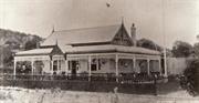
Hymus House & Outbuildings, a Victorian bungalow style house constructed of vuggy lacustrine limestone and a roof clad in corrugated galvanised iron, together with outbuildings including Workers’ Quarters and Dairy, has cultural heritage significance for the following reasons: •The place is a visually prominent element in the East Rockingham landscape, and is a landmark on Mandurah Road; •The place is a rare example of a vuggy lacustrine limestone structure, a local construction material commonly used in the East Rockingham area until the post-World War Two period; •The House has aesthetic value arising from its physical proportions and construction in local stone; •The place is a rare component of a clearly definable collection of buildings and sites from the early settlement of the district; •The place has a strong association with the Hymus family who were among the earliest settlers in East Rockingham and were involved in the social and civic development of the district; •The place is associated with the Stokes family who owned land and farmed in the district from the early 20th century up to the 1970s; •The place contributes to the district’s sense of history and permanence.
Restored single storey bungalow of vuggy limestone masonry construction with a corrugated iron hipped roof, penetrated by a brick chimney topped with two clay pots. The roughly square plan bungalow and surrounding planted garden of mature shrubs and lawn are contained by a fence of brick piers and flat top timber palings atop low stone walls. The limestone walls of the building have been rendered, painted and feature timber framed windows with face brick quoining. The attached verandah is covered by an extension of the roof with a break of pitch, supported on timber posts and raised two steps from ground level. The surrounding outbuildings are no longer extant including the former dairy building, loading ramp, shed with lean-to and concrete water tank.
The Hymus family was among the first to settle in east Rockingham in the 1850s. Daniel Hymus (1835-1920) (senior), who ran the then Port (now Rockingham) hotel, and his wife Fanny (nee Bell) (1848-1913) acquired the land on which Hymus house now sits in 1878 and lived in an earlier dwelling. Their son Daniel (1876-1932) built the current house c1895. In 1935, the property was sold to farmer Joseph Stokes who developed it as a dairy. In 2006, the cultural value of Hymus House was recognised officially when it was placed on the State Register of heritage Places. In early 2007, subdivision of old farmland surrounding Hymus house was approved, subject to the establishment of a Heritage Agreement which required urgent conservation works which included securing the building, replacing the roof sheeting was replaced and rebuilding the verandahs. The new owners restored the building as the company’s administrative office.
Integrity: Moderate Degree Authenticity: High Degree
Excellent
| Ref ID No | Ref Name | Ref Source | Ref Date |
|---|---|---|---|
| Hymus House Conservation Management Plan | |||
| City of Rockingham Municipal Heritage Investory | |||
| Landgate Aerial Photos | |||
| State Heritage Office |
| Reserve | Lot/Location | Plan/Diagram | Vol/Folio |
|---|---|---|---|
| 804 | 55354 |
| Owner | Category |
|---|---|
| Kalari Pty Ltd | Other Private |
This information is provided voluntarily as a public service. The information provided is made available in good faith and is derived from sources believed to be reliable and accurate. However, the information is provided solely on the basis that readers will be responsible for making their own assessment of the matters discussed herein and are advised to verify all relevant representations, statements and information.
90 Office Rd East Rockingham
Includes the East Rockingham School (site). Lot 622 on Plan 117585.
Roads Boards Office and East Rockingham School - Site
Rockingham
Metropolitan
Constructed from 1905
| Type | Status | Date | Documents |
|---|---|---|---|
| (no listings) |
| Type | Status | Date | Documents |
|---|---|---|---|
| RHP - To be assessed | Current | 19 Apr 2013 |
| Type | Status | Date | Grading/Management | |
|---|---|---|---|---|
| Category | ||||
| Municipal Inventory | Adopted | 24 Apr 2018 | Category E | |
03841 East Rockingham Heritage Precinct
| Library Id | Title | Medium | Year Of Publication |
|---|---|---|---|
| 11871 | Rockingham Road Board Offices (fmr) Kent Street, Rockingham | Heritage Study {Cons'n Plan} | 2021 |
Historic Site
| Epoch | General | Specific |
|---|---|---|
| Present Use | VACANT\UNUSED | Vacant\Unused |
| Original Use | GOVERNMENTAL | Town, Shire or District Hall |
| Original Use | EDUCATIONAL | Primary School |
This information is provided voluntarily as a public service. The information provided is made available in good faith and is derived from sources believed to be reliable and accurate. However, the information is provided solely on the basis that readers will be responsible for making their own assessment of the matters discussed herein and are advised to verify all relevant representations, statements and information.
• The place has historic value for its association with the Rockingham Roads Board, first formed in 1897, which included prominent local members C. Parkin, J. Thorpe, D. Hymus, John Bell, James Bell, W. Day and G. Mead. • The place has historic value for its association with the earliest school in East Rockingham established in 1897 which function at this site until 1975.
Plaque to commemorate the proclamation of Rockingham to city status on 12 November 1988. The original road board’s building has been lost and the corner site is now a Water Corporation site with no other indication that a building was located there apart from the memorial.
The Rockingham Roads Board was established in 1897 with inaugural members John Thorpe, William Day, George Mead, John and James (Jnr) Bell, Daniel Hymus and Charles Parkin, J.P. who was the Chairman. In 1905, a small one roomed timber building, with a stone frontage was built on this site on the corner of Office Road and Mandurah Road. In 1933, the Roads Board office was leased by the Education Department to supplement accommodation for the East Rockingham School, which was located on the other side of Mandurah Road on the corner of Wellard Road. At the same time, the Roads Board decided that their office was too far from the town and eventually moved into a rented accommodation at Rockingham. In the following year, a contract was let to A. Woodhouse for a new 30 foot by 20 foot school room on the block of land on Office Road, adjoining the old Road Boards Office. These buildings were sufficient until 1953, when the construction of the Oil Refinery at Kwinana brought a sudden increase in the number of scholars and subsequently, a two-room Bristol prefabricated building was added to the school. In later years, the number of scholars declined due to the development of Medina and decline in Kwinana Beach as a residential area. The school was closed in c. 1975 and the buildings were removed. In 1929, the Rockingham Road Board requested the State Centenary Committee that a tablet be placed at the East Rockingham School site (cnr Wellard and Mandurah Roads) as it was believed at that time to be the oldest school still operating in the state. It has not been established if a tablet was installed at the site and there is no evidence of a table at the site today [2017].
| Reserve | Lot/Location | Plan/Diagram | Vol/Folio |
|---|---|---|---|
| 622 | 98871 |
This information is provided voluntarily as a public service. The information provided is made available in good faith and is derived from sources believed to be reliable and accurate. However, the information is provided solely on the basis that readers will be responsible for making their own assessment of the matters discussed herein and are advised to verify all relevant representations, statements and information.
Lot 439 Rockingham Beach Rd East Rockingham
Lot 439 on Plan 205970
Rockingham
Metropolitan
Constructed from 1971
| Type | Status | Date | Documents |
|---|---|---|---|
| Heritage List | Adopted | 01 Mar 2008 |
| Type | Status | Date | Documents |
|---|---|---|---|
| (no listings) |
| Type | Status | Date | Grading/Management | |
|---|---|---|---|---|
| Category | ||||
| Municipal Inventory | Adopted | 24 Apr 2018 | Category B | |
Historic site
| Epoch | General | Specific |
|---|---|---|
| Original Use | MONUMENT\CEMETERY | Monument |
| Type | General | Specific |
|---|---|---|
| Wall | STONE | Other Stone |
This information is provided voluntarily as a public service. The information provided is made available in good faith and is derived from sources believed to be reliable and accurate. However, the information is provided solely on the basis that readers will be responsible for making their own assessment of the matters discussed herein and are advised to verify all relevant representations, statements and information.
Constructed from 1971
•The place has historic value for its association with the dramatic arrival of the ship 'Rockingham' which gave its name to the town. •The place has social value for the community of Rockingham who organised to build this memorial in the 1970s and for its ongoing presence in the community since then. •The place has historic value for its association with the moment in Western Australia's history in which the population exceeded one million which provided a marker of the development of the state
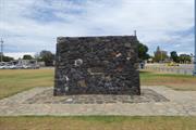
Stone monument characterised by its random coursing and curved form. The monument is approximately 2.5 m tall located in Governor Reserve at the northern end of the foreshore parks. The cairn has two plaques commemorating the population of Western Australia reaching 1 million citizens in 1971 and the ship ‘Rockingham’ bringing 172 settlers to the Swan River Colony in 1873.
This cairn was erected in 1971 by the Shire of Rockingham to commemorate two significant events. The first event was when the ship 'Rockingham' was blown ashore near the site during a storm on 14th May 1830. No lives were lost in the disaster and the ship was saved. Those on board the vessel were 172 settlers including 75 children who had taken the journey from England to settle in the new colony. The second event marked by this cairn was when the population of Western Australia exceeded one million people in 1971. The Rockingham District Historical Society contributed to the construction of the cairn. A ceremony was held on 28th May 1971 by the local MLA E. C. Rushton to unveil the plaques. The stones used in the construction of the cairn were ballast stones brought by sailing ships to the port of Rockingham.
Integrity: High Degree Authenticity: High Degree
Good
| Ref ID No | Ref Name | Ref Source | Ref Date |
|---|---|---|---|
| Landgate Land Information and aerial photographs | |||
| City of Rockingham Municipal Heritage Investory | City of Rocking MHI | September 2012 |
| Reserve | Lot/Location | Plan/Diagram | Vol/Folio |
|---|---|---|---|
| 439 | 205970 |
This information is provided voluntarily as a public service. The information provided is made available in good faith and is derived from sources believed to be reliable and accurate. However, the information is provided solely on the basis that readers will be responsible for making their own assessment of the matters discussed herein and are advised to verify all relevant representations, statements and information.
Garden Island
Lot 9 on Plan 226190
Rockingham
Metropolitan
Constructed from 1908
| Type | Status | Date | Documents |
|---|---|---|---|
| (no listings) |
| Type | Status | Date | Documents |
|---|---|---|---|
| (no listings) |
| Type | Status | Date | Grading/Management | |
|---|---|---|---|---|
| Category | ||||
| Municipal Inventory | Adopted | 24 Apr 2018 | Category E | |
Historic Site
| Epoch | General | Specific |
|---|---|---|
| Original Use | RESIDENTIAL | Other |
| Present Use | OTHER | Other |
This information is provided voluntarily as a public service. The information provided is made available in good faith and is derived from sources believed to be reliable and accurate. However, the information is provided solely on the basis that readers will be responsible for making their own assessment of the matters discussed herein and are advised to verify all relevant representations, statements and information.
Constructed from 1908
• The site has historic value for its association with the time in which Garden Island was used as a holiday destination. • The site has historic value for its association with John Frederick Mills and his family.
The original residence was demolished in the 1970s with the only remaining element being the large pine tree.
John Frederick Mills (1872-1959) was an early resident of Garden Island and built his holiday home there c1908. Born in NSW, Mills settled in Western Australia c1900 to establish a pottery business in Maylands. His family settled in Maylands and lived there until his death in 1959. John Mills took a lease of land on Garden Island and built a holiday home for his family. The materials for the house were ferried on barges from Fremantle. The house was demolished sometime in the 1970s and the large pine tree planted in the grounds of the property is the only evidence of the former residence.
| Reserve | Lot/Location | Plan/Diagram | Vol/Folio |
|---|---|---|---|
| 9 | 226190 |
This information is provided voluntarily as a public service. The information provided is made available in good faith and is derived from sources believed to be reliable and accurate. However, the information is provided solely on the basis that readers will be responsible for making their own assessment of the matters discussed herein and are advised to verify all relevant representations, statements and information.
Careening Bay Garden Island
Careening Bay, Garden Island, about 200m offshore, at latitude 32deg14'15"S longitude 115deg41'29"E.
Rockingham
Metropolitan
| Type | Status | Date | Documents |
|---|---|---|---|
| (no listings) |
| Type | Status | Date | Documents |
|---|---|---|---|
| (no listings) |
| Type | Status | Date | Grading/Management | |
|---|---|---|---|---|
| Category | ||||
| Register of the National Estate | Registered | 21 Mar 1978 | ||
Historic Site
| Epoch | General | Specific |
|---|---|---|
| Original Use | OTHER | Other |
This information is provided voluntarily as a public service. The information provided is made available in good faith and is derived from sources believed to be reliable and accurate. However, the information is provided solely on the basis that readers will be responsible for making their own assessment of the matters discussed herein and are advised to verify all relevant representations, statements and information.
Cockburn Sound Locations 9 & 696 Garden Island
The 'parent' for this record is P4501 Garden Island. The 'child' for this record is P3301 Challenger Battery (also known as J Gun Battery). This is one of the four batteries included in this record & it has also been identified individually. The remaining 3 batteries do not have individual records.
Beacon Battery
Challenger (J Gun) Battery
Scriven Hill Battery and Collie Section Battery
Rockingham
Metropolitan
| Type | Status | Date | Documents |
|---|---|---|---|
| Heritage List | Adopted | 01 Mar 2008 |
| Type | Status | Date | Documents |
|---|---|---|---|
| (no listings) |
| Type | Status | Date | Grading/Management | |
|---|---|---|---|---|
| Category | ||||
| Municipal Inventory | Adopted | 24 Apr 2018 | Category A | |
| Register of the National Estate | Registered | 30 May 1995 | ||
04501 Garden Island
Individual Building or Group
| Epoch | General | Specific |
|---|---|---|
| Original Use | MILITARY | Fort or Gun Emplacement |
| Original Use | MILITARY | Other |
This information is provided voluntarily as a public service. The information provided is made available in good faith and is derived from sources believed to be reliable and accurate. However, the information is provided solely on the basis that readers will be responsible for making their own assessment of the matters discussed herein and are advised to verify all relevant representations, statements and information.
Garden Island Battery Complex is a collection of structures constructed in 1943 including gun emplacements, observation posts, operations and ammunitions bunkers, and several other ancillary elements which together were part of a network of defence strategies around the port of Fremantle. The place has cultural heritage significance for the following reasons; • the place, together with the other elements of Western Australia’s coastal defence system, known as ‘Fremantle Fortress’ erected in response to external threats during WWII and together have the potential to yield information about coastal defence strategies; • the Battery Complex demonstrates technical achievement in its design – the guns were placed to enable them to cover any shipping approaching within range south of Rockingham and Safety Bay and the western approaches to Garden Island, as well as providing cover for the boom defence which was laid across South Channel; • the remaining built elements of Garden Island Battery are representative of WWII coastal defence architecture, of functional design and simplistic but robust construction used by the military engineers in a remote sand dune environment; • Garden Island Battery is associated with members of the Australian Army specifically the Artillery who served at this site or similar batteries. It is also valued by members of this cohort for its demonstration of past techniques and practices;
The four batteries are in various conditions. All are constructed to a military template seen in other sites along the Fremantle Fortress coastline including Oliver Battery on Rottnest, ‘k’ Battery on Point Peron and Leighton Battery. All are functional and utilitarian in design and form, being constructed of brick and reinforced concrete.
In the 1930s seabourne trade, both coastal and overseas was still of great importance to Australia. The incident of the Graman raider the Emden near the Cocos Islands in November 1914 highlighted the vulnerability of the west coast of Australia. The ‘Singapore Strategy’ was adopted in Australian defence policy with reliance on a strong Navy for Australian defence over a standing army and air force. Because of the deteriorating international situation the Commonwealth Government started to construct a network of coastal defences. The 1941 sinking of HMAS Sydney off the coast of Western Australia and the fall of Singapore in 1942 reinforced the feeling of vulnerability of the western coast and the importance of Fremantle. New coastal defences were concentrated around Fremantle. By 1944 Fremantle was protected by one of the largest and most comprehensive gun systems available for any Australian port—nine coastal batteries manned by 47 officers and 829 other ranks. The defences covered all approaches to the port from seaward. The Fremantle harbour, as well as being a vital trade port for Australia, provided a base to Allied submarines with some 170 submarine making a total of 416 highly successful war patrols out of Fremantle during World War II. Boom defences were installed at Cockburn Sound in 1942 to protect shipping against enemy submarines—submerged nets attached to jarrah poles into the sea bed at north and south of the island. The German Navy conducted a U-Boat campaign in the Indian Ocean in late 1944 to foil allied ships gaining provisions from Australia for the impending invasion of Europe. The four gun batteries established on Garden Island as fixed coastal defences were part of the larger network of coastal defences. Challenger Battery (‘J’ Battery) on the northwest coast with two 155mm guns—was matched by a similar battery on Rottnest and protected access to the Port of Fremantle. Built in 1942 it was also positioned to assist the Peron Battery in the defence of Cockburn Sound. Beacon Battery on the northeast coast was built second and Collie Battery on the south coast. Both had two 4-inch embanked guns each to protect the submarine booms. Beacon was to protect the seaward leg of the naval boom defence. Collie was to protect the boom defence barrier extending from the island to Cape Peron. Scriven Battery on the west coast with two 9.2-inch guns. It was the last to be built and its two guns provided the seaward defence system. To support the batteries the island was developed with roads, water supply, power and communication facilities. Two anti-aircraft search light stations and two anti-aircraft gun stations were also constructed in addition to three forward observation posts. The personnel required to service these facilities were housed on the island, largely in tents and little evidence remains of these elements apart from changes in the landscape as a result of the dug-outs for latrines. The development of improved air protection for Australia subsequently reduced the need for naval protection and the need for coastal defences during World War II. The Gun covers at Scriven were never completed. By 1945 all guns had been removed apart from Scriven which was placed in combat storage and sold for scrap in 1962.
Integrity: Moderate Authenticity: High
Fair to ruins
| Reserve | Lot/Location | Plan/Diagram | Vol/Folio |
|---|---|---|---|
| 9 | 226190 |
This information is provided voluntarily as a public service. The information provided is made available in good faith and is derived from sources believed to be reliable and accurate. However, the information is provided solely on the basis that readers will be responsible for making their own assessment of the matters discussed herein and are advised to verify all relevant representations, statements and information.
Entrance Pnt Garden Island
"J" Heavy Battery
Rockingham
Metropolitan
Constructed from 1943
| Type | Status | Date | Documents |
|---|---|---|---|
| Commonwealth List | Adopted | 22 Jun 2004 |
| Type | Status | Date | Documents |
|---|---|---|---|
| (no listings) |
| Type | Status | Date | Grading/Management | |
|---|---|---|---|---|
| Category | ||||
| Municipal Inventory | Adopted | Category A | ||
| Classified by the National Trust | Classified | 07 Dec 1992 | ||
18495 Garden Island Batteries
| Name | Type | Year From | Year To |
|---|---|---|---|
| COMMONWEALTH GOVERNMENT | Architect | - | - |
Individual Building or Group
| Epoch | General | Specific |
|---|---|---|
| Present Use | SOCIAL\RECREATIONAL | Other |
| Original Use | MILITARY | Fort or Gun Emplacement |
| General | Specific |
|---|---|
| OUTSIDE INFLUENCES | World Wars & other wars |
This information is provided voluntarily as a public service. The information provided is made available in good faith and is derived from sources believed to be reliable and accurate. However, the information is provided solely on the basis that readers will be responsible for making their own assessment of the matters discussed herein and are advised to verify all relevant representations, statements and information.
Constructed from 1943
Aesthetic Value: The various batteries were located to exploit the natural terrain of Garden Island, and form attractive and evocative ruin-like structures throughout the island. Historic Value: J Gun Battery is historically important as the first gun battery constructed on Garden Island. The gun mountings and magazine buildings demonstrate the principal characteristics of coastal gun batteries constructed during WWII and the overlapping fields of fire achieved through strategic siting of individual batteries as part of a network. The batteries and magazine structures exhibit design innovation in their successful use of reinforced concrete and brick. Important part of the coastal defense gun batteries constructed during Second World War. Social Value: The places are valued by the community as remind- ers of the role of Garden Island and Fremantle in the coastal defence of the west coast following the entry of Japan into the Second World War.
Scriven Hill Battery is the largest of the former battery complexes and comprises the remains of a pair of concrete gun emplacements, located approximately 250m apart, as well as a number of brick and concrete shelters connected by tunnels, and a concrete magazine building. The structures are considerably overgrown with native vegetation and also partially covered by sand. One of the shelters has been considerably damaged by an explosion. Challenger Battery and Beacon Battery are located at the northern most end of Garden Island and are also overgrown. They comprise the remains of concrete gun emplacements (typically circular in plan) and a number of concrete and brick shelters.
During the Second World War, Cockburn Sound was protected by anti-aircraft guns on Garden Island and the mainland. The first of these to be established - J Gun Battery or Challenger Battery, in 1942 - was located at the north western tip of the island. A second complex, Beacon Battery, completed in the same year, was located at Beacon Head. The two largest gun emplacements were constructed late in 1943 on Scriven Hill in the centre of Garden Island. This complex included its own shell store, magazine, pump chamber and power house in addition to a plotting room and command post and battery observation posts. The two guns were to be located 250 yards apart. Scriven Battery was never completed and the guns were sold for scrap in 1962. A boom barrier was positioned to control access to the sound from the south. Collie Section Battery at Collie Head was intended to defend the boom in conjunction with a battery at Peron Head on the mainland. These batteries were complemented by the construction gun batteries on Rottnest Island and coastal batteries on the mainland extending from Swanbourne in the north to Rockingham in the south. Special training units, including the Z Force Unit, were also stationed at Garden Island during the War.
Integrity: High Degree Authenticity: High Degree
Fair
| Reserve | Lot/Location | Plan/Diagram | Vol/Folio |
|---|---|---|---|
| 9 | 226190 |
This information is provided voluntarily as a public service. The information provided is made available in good faith and is derived from sources believed to be reliable and accurate. However, the information is provided solely on the basis that readers will be responsible for making their own assessment of the matters discussed herein and are advised to verify all relevant representations, statements and information.
Sulphur Bay Garden Island
Lot 9 on Plan 226190
Foundations of Stirling's Hut
Well at Sulphur Bay and Sulphur Town
Rockingham
Metropolitan
Constructed from 1829
| Type | Status | Date | Documents |
|---|---|---|---|
| Commonwealth List | Adopted | 22 Jun 2004 | |
| Heritage List | Adopted | 01 Mar 2008 |
| Type | Status | Date | Documents |
|---|---|---|---|
| (no listings) |
| Type | Status | Date | Grading/Management | |
|---|---|---|---|---|
| Category | ||||
| Register of the National Estate | Registered | 15 May 1990 | ||
| Municipal Inventory | Adopted | 24 Apr 2018 | Category A | |
04501 Garden Island
Historic Site
| Epoch | General | Specific |
|---|---|---|
| Present Use | MONUMENT\CEMETERY | Monument |
| Original Use | MILITARY | Other |
| General | Specific |
|---|---|
| PEOPLE | Early settlers |
| DEMOGRAPHIC SETTLEMENT & MOBILITY | Settlements |
This information is provided voluntarily as a public service. The information provided is made available in good faith and is derived from sources believed to be reliable and accurate. However, the information is provided solely on the basis that readers will be responsible for making their own assessment of the matters discussed herein and are advised to verify all relevant representations, statements and information.
Constructed from 1829
• The site has historic value for its association with the first site occupied by Governor Stirling’s party in 1829 when founding the colony. • The place has research value for its potential for archaeological finds due to its relative isolation and undisturbed condition.
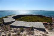
A large memorial has been built on Cliff Head, comprising a circular concrete platform with two commemorative plaques mounted on piers and an abstracted coastal map showing the relationship between Rottnest Island, Penguin Island, Garden Island and the mainland it is also representative of the Waugal. Nearby the monument is a well, known as Stirling Well, which was dug by hand and believed to date from the early settlement. Archaeological evidence is also likely to be in evidence given the minimal disturbance since the early 19th century.
Garden Island, known as Meeandip by the local Nyungar people, was named IIe de Bauche during the expedition led by Frenchman Nicholas Baudin in 1801. In 1827, Captain James Stirling visited the Swan River region and reported favourably on the area. Before returning to Britain, Stirling landed surplus livestock from his ship on the Ile de Buache. In 1828, Stirling sailed again for the Swan River in order to establish a permanent settlement. Captain Charles Fremantle, commanding the gun boat Challenger, was sent ahead of the main party and he arrived on the island he renamed Garden Island in April 1829. Fremantle prepared the place for the arrival of Stirling and the settlers in the following month aboard the ships, Sulphur and the Parmelia. On Garden Island, a well was dug, ground cleared and prepared for gardens. In addition, huts, stores, stockyards and roads were constructed. The small settlement at Sulphur Bay grew to accommodate over 400 people, including the ship’s crew. Within two months, surveys of proposed land grants in the Swan River region were completed, and the movement of free settlers to the mainland commenced. The Sulphur Town settlement came to an end in 1834 when crew from the ‘Lonach’ accidently burnt the down the entire village after they came ashore at Cliff Head on Sulphur Bay. The site has been burned a number of times since 1834 and it is overgrown with shrubs and some introduced plant species. Archaeological remains which have been identified include a small patch of limestone believed to be site of Stirling’s Hut; a well; and, the site of a bottle dump. Areas of the site are considered to have some archaeological potential due to the relative lack of disturbance and heavy bush. A memorial to the early settlement was built at Cliff Head overlooking Sulphur Bay in 1979 as part of the Western Australian celebrations of the 150th year since the arrival of Captain James Stirling and settlers.
Integrity: None Authenticity: Little
Good although evidence of spalling in the concrete is visible due to the rusting of the reinforcements
| Reserve | Lot/Location | Plan/Diagram | Vol/Folio |
|---|---|---|---|
| 9 | 226190 |
This information is provided voluntarily as a public service. The information provided is made available in good faith and is derived from sources believed to be reliable and accurate. However, the information is provided solely on the basis that readers will be responsible for making their own assessment of the matters discussed herein and are advised to verify all relevant representations, statements and information.
178 Dampier Dr Golden Bay
Thomas Peel Juniors Homestead
Thomas Peel Reserve
Rockingham
Metropolitan
Constructed from 1860
| Type | Status | Date | Documents |
|---|---|---|---|
| Heritage List | Adopted | 24 Apr 2018 |
| Type | Status | Date | Documents |
|---|---|---|---|
| RHP - Assessed - Below Threshold | Current | 22 Feb 2013 |
| Type | Status | Date | Grading/Management | |
|---|---|---|---|---|
| Category | ||||
| Municipal Inventory | Adopted | 24 Apr 2018 | Category A | |
Ruins
| Library Id | Title | Medium | Year Of Publication |
|---|---|---|---|
| 9736 | Peelhurst ruins. Lot 40 Dampier Drive, Golden Bay. | Heritage Study {Cons'n Plan} | 2011 |
Historic Site
| Epoch | General | Specific |
|---|---|---|
| Present Use | PARK\RESERVE | Park\Reserve |
| Original Use | RESIDENTIAL | Other |
This information is provided voluntarily as a public service. The information provided is made available in good faith and is derived from sources believed to be reliable and accurate. However, the information is provided solely on the basis that readers will be responsible for making their own assessment of the matters discussed herein and are advised to verify all relevant representations, statements and information.
Constructed from 1860
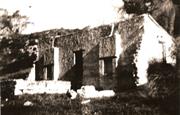
The following statement is taken from the Peelhurst Ruins Conservation Management Plan prepared in 2010. Peelhurst ruins are the remains of a single storey limestone rubble cottage built c.1860 by Thomas Peel Jnr (Tom Peel) as his residence. Adjacent to the ruins are plantings which demonstrate former occupancies. These include an olive tree, fig trees and introduced plantings used for decorative purposes and kitchen garden plants. The ruins are located within an informally landscaped setting which features a former track and depression, which may relate to water procurement or storage. The place has cultural heritage significance for the following reasons; • Peelhurst ruins are an example of early stone construction in the Rockingham region which demonstrate the form and scale of housing in the mid-19th century. • The place is associated with the earliest settler in the region, Tom Peel who established his landholding, Peelhurst in the early 1860s. It is also associated with the Paterson family who owned the landholding from 1882 to 1949 who were significant in the establishment of farming in the region; • The use of ticket-of-leave labour in the construction and establishment of the Peelhurst landholding and possibly the cottage is indicative of the type of work undertaken by these men and demonstrates the contribution they made to the development of the colony in the 19th century; • Peelhurst ruins are of exceptional archaeological significance. Preliminary research has established artefact deposits located to the west of the site and there is potential for artefacts to be located in the subsurface deposits within and around the ruin, relating to the occupation and use of the place; • The presence of the adjacent fig trees is of value as it demonstrates the evolution of farming practice in Western Australia in response to local conditions, and; • The place has aesthetic value as a landmark within Golden Bay and for its scenic collection of elements within the natural landscape.
Limestone ruins of the former Peelhurst cottage. Evidence of the floor plan remains partially evident but the majority of the fabric has been lost. Legibility of the cottage is no longer evident. The remaining fabric is deteriorating quite rapidly.
Peelhurst ruins are the remnants of a stone cottage built by Thomas Peel Jr (Tom Peel) in the early 1860s. The cottage was within a large landholding which Tom Peel named ‘Peelhurst’. The cottage was never completed but was occupied by Peel and his housekeeper Mrs Spencer until approximately 1882 when the property was sold to brothers William and George Paterson. The Paterson’s acquired the landholding, to provide a coastal run for their sheep from their property ‘Creaton’ in Pinjarra. The cottage was not permanently occupied during ownership by the Paterson family although a caretaker did occupy the cottage for some periods. The Paterson’s subdivided the large landholding and in 1949 the lot on which the Peelhurst ruins were located was sold to engineer Cyril Robbins. In the 1960s, the large landholding was subdivided for residential lots and sold under the name ‘Golden Bay’. Since that time Golden Bay has slowly developed from a holiday destination to being absorbed within the greater Perth metropolitan area. The lot on which Peelhurst ruins are located was acquired by the City of Rockingham in 1991 and it has been maintained as a reserve since that time.
Integrity: Low Authenticity: Low
Poor
| Reserve | Lot/Location | Plan/Diagram | Vol/Folio |
|---|---|---|---|
| 40 | 80615 |
| Owner | Category |
|---|---|
| City of Rockingham | Local Gov't |
This information is provided voluntarily as a public service. The information provided is made available in good faith and is derived from sources believed to be reliable and accurate. However, the information is provided solely on the basis that readers will be responsible for making their own assessment of the matters discussed herein and are advised to verify all relevant representations, statements and information.
Cnr Dixon Rd & Darile St Hillman
Rockingham
Metropolitan
Constructed from 1940
| Type | Status | Date | Documents |
|---|---|---|---|
| Heritage List | Adopted | 24 Apr 2018 |
| Type | Status | Date | Documents |
|---|---|---|---|
| RHP - Does not warrant assessment | Current | 19 Apr 2013 |
| Type | Status | Date | Grading/Management | |
|---|---|---|---|---|
| Category | ||||
| Municipal Inventory | Adopted | 24 Oct 1995 | Category A | |
| Library Id | Title | Medium | Year Of Publication |
|---|---|---|---|
| 9471 | The old abattoir, cnr Dixon and Day Roads, Hillman WA conservation plan for City of Rockingham. | Heritage Study {Cons'n Plan} | 1999 |
| 9470 | The old abattoir, Hillman, conservation plan (review). | Heritage Study {Cons'n Plan} | 2009 |
| 8421 | Urgent works report : East Rockingham heritage precinct. | Book | 1998 |
Individual Building or Group
| Epoch | General | Specific |
|---|---|---|
| Present Use | INDUSTRIAL\MANUFACTURING | Abbatoir |
| Original Use | INDUSTRIAL\MANUFACTURING | Abbatoir |
This information is provided voluntarily as a public service. The information provided is made available in good faith and is derived from sources believed to be reliable and accurate. However, the information is provided solely on the basis that readers will be responsible for making their own assessment of the matters discussed herein and are advised to verify all relevant representations, statements and information.
Constructed from 1940
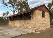
• The place has aesthetic value as a landmark as a rustic building in a rural landscape surrounded by large established trees. • The place has historic value as a key component of the East Rockingham heritage precinct. • The place has historic value for its associated with the provision of abattoir services to the local population during WWII. • The place has historic value for its association with equestrian activities that were a dominant activity in the district. • The design of the abattoir has research value as it indicates the processes associated with a small-scale slaughtering operation in the early 1940s. • The place is rare as an extant example of a small scale abattoir.
The ruins of the limestone abattoir building are located on a prominent corner site and forms part of the Dixon Road Conservation Precinct. The place is of limestone construction which has undergone some repointing in the past. Conservation works are being scheduled with preparatory works already undertaken including the removal of the extant roofing fabric and the window frames to the Darile Street elevation. This fabric has been retained and will be reinstated. A small number of hard wood roof members remain extant. Marseille tiles and timber gables have been removed in accordance with conservation schedules prepared by conservation practitioners. The site has been secured by wire fencing and locked gate. An interpretive display has been installed outside the fence enclosing the site.
In 1940, Oliver (Crom) Wilson and his family moved into the Rockingham district. Wilson, and his partner Sydney Dixon, were partners in two butcher shops, one in Penguin Road, Safety Bay and the other in Rockingham Road. Possibly as a consequence of war time restrictions during the early 1940s, which made the availability of fresh meat difficult, Wilson and Dixon built their abattoir on Lot 11 near Day Road and arranged for their own supplies of stock. The abattoir was of sound construction being built of local limestone blocks, possibly quarried from Sam Chalwell's property further north off Day Road. Sydney Dixon's daughter recalls that it was during the early war years when her father and Crom Wilson built and operated the abattoir. According to local knowledge, Wilson and Dixon employed Sam Chalwell, a keen horseman who lived close by, to select the cattle and sheep from local outlets, and possibly others further afield, and drive the stock to the abattoir. The stock would then be held in yards on the site. In 1952, Wilson sold the abattoir site to Raymond Patrick Connolly, a retired farmer of Mundijong, who apparently converted the abattoir building into a dairy. Connolly also owned trotters and a circular track, possibly a training track is visible on a 1972 aerial photograph of the site. Connolly also leased portion of the land to other trainers and over the years several other structures for the horses were built on the site. All the structures including a small cottage have subsequently been removed except for the former abattoir. In mid-2016, the roof cladding was removed as part of a conservation strategy for the place.
Integrity: Low Degree Authenticity: Moderate Degree
Poor
| Reserve | Lot/Location | Plan/Diagram | Vol/Folio |
|---|---|---|---|
| 52208 | 501 | 77249 |
| Owner | Category |
|---|---|
| Dep't for Planning & Infrastructure | State Gov't |
This information is provided voluntarily as a public service. The information provided is made available in good faith and is derived from sources believed to be reliable and accurate. However, the information is provided solely on the basis that readers will be responsible for making their own assessment of the matters discussed herein and are advised to verify all relevant representations, statements and information.