Local Government
Rockingham
Region
Metropolitan
Cnr Wanliss and Smythe Sts Rockingham
Rockingham
Metropolitan
Constructed from 1956
| Type | Status | Date | Documents |
|---|---|---|---|
| (no listings) |
| Type | Status | Date | Documents |
|---|---|---|---|
| RHP - Assessed - Below Threshold | Current | 12 Nov 2004 |
| Type | Status | Date | Grading/Management | |
|---|---|---|---|---|
| Category | ||||
| (no listings) | ||||
| Library Id | Title | Medium | Year Of Publication |
|---|---|---|---|
| 7833 | Rockingham infant health centre: detailed archival record. | Archival Record | 2005 |
| 7834 | Rockingham infant health centre: interpretation plan. | Heritage Study {Other} | 2005 |
| 7024 | Images CD No. 28 : assessment images : Jutland Parade Group, Pindar Garage, Presentation Convent, Mullewa Railway Station Group, Rockingham Infant Health Group. | C D Rom | 2004 |
Individual Building or Group
| Epoch | General | Specific |
|---|---|---|
| Present Use | HEALTH | Other |
| Original Use | HEALTH | Other |
| Style |
|---|
| Late 20th-Century Perth Regional |
| Type | General | Specific |
|---|---|---|
| Roof | TILE | Terracotta Tile |
| Wall | BRICK | Common Brick |
| General | Specific |
|---|---|
| SOCIAL & CIVIC ACTIVITIES | Community services & utilities |
This information is provided voluntarily as a public service. The information provided is made available in good faith and is derived from sources believed to be reliable and accurate. However, the information is provided solely on the basis that readers will be responsible for making their own assessment of the matters discussed herein and are advised to verify all relevant representations, statements and information.
1 Council Av Rockingham
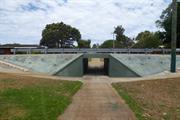
7 underpasses from Centaurus Street, Read St, Council Av through to Rockingham Park Shopping Centre
Rockingham
Metropolitan
Constructed from 1969
| Type | Status | Date | Documents |
|---|---|---|---|
| Heritage List | Adopted | 24 Apr 2018 |
| Type | Status | Date | Documents |
|---|---|---|---|
| (no listings) |
| Type | Status | Date | Grading/Management | |
|---|---|---|---|---|
| Category | ||||
| Municipal Inventory | Adopted | 24 Oct 1995 | Category C | |
Other Built Type
| Epoch | General | Specific |
|---|---|---|
| Original Use | Transport\Communications | Road: Other |
| Present Use | Transport\Communications | Road: Other |
This information is provided voluntarily as a public service. The information provided is made available in good faith and is derived from sources believed to be reliable and accurate. However, the information is provided solely on the basis that readers will be responsible for making their own assessment of the matters discussed herein and are advised to verify all relevant representations, statements and information.
Constructed from 1969
• The place has historic value for its association with the expansion and development of the Rockingham district in the 1960s. • The place has historic value for its association with architect and planner, Paul Ritter who was a significant player in the development of Western Australia's knowledge of planning and architecture in the public realm.
A collection of seven underpasses around the Rockingham Park area. Each underpass was constructed to the same design and method using precast concrete but each contained a different mural including Kangaroos and Grass trees; sharks and other ocean life; mechanics; symbols and birds. All have been painted green and only two of the underpasses still present with coloured motifs.
This series of underpasses were designed in 1969 by architect and planner, Paul Ritter. Ritter was a controversial and colourful figure in Western Australia during the 1960s and 1970s. He was trained in England and was brought to the City of Perth to advance local knowledge and philosophies of planning and design. Appointed as the City of Perth's first City Planner in 1965 he was dismissed in 1967 but engendered significant public support which led to his election as a City of Perth councillor from 1968 to 1986. He established his own practice, Paul Ritter and Associates and worked as a planner and architect in Western Australia. He was well known for exploring new techniques and philosophies, particularly in relation to art and design in the public realm. These underpasses which incorporate murals are representative of his design philosophy which he describes in his book 'Concrete Fit for People: A Practical Approach to a Bio-Functional Eco-Architecture for the Third Millennium A.D.' His designs of seven underpasses recognised that the underpasses would be subject to vandalism so his designs 'incorporates the idea of violent attacks on it. They are anticipated and planned for, positively.' The concrete was caste by Rocla Pipes Co and the 'Sculp-crete' work and play sculpture ideas by Paul Ritter.
Integrity: High Degree Authenticity: High Degree
Good
This information is provided voluntarily as a public service. The information provided is made available in good faith and is derived from sources believed to be reliable and accurate. However, the information is provided solely on the basis that readers will be responsible for making their own assessment of the matters discussed herein and are advised to verify all relevant representations, statements and information.
Day Rd Rockingham
nr junction of Dixon Rd To be assessed as part of P3841 Est Rockingham Heritage Precinct
Ellendale
Rockingham Inn
Rockingham
Metropolitan
Constructed from 1882 to 1970
| Type | Status | Date | Documents |
|---|---|---|---|
| Heritage List | Adopted | 24 Apr 2018 | |
| Heritage Agreement | YES | 13 Jun 2023 | HCWebsite.Listing+ListingDocument |
| State Register | Registered | 04 May 2001 | HCWebsite.Listing+ListingDocument, HCWebsite.Listing+ListingDocument |
| Type | Status | Date | Documents |
|---|---|---|---|
| RHP - To be assessed | Current | 19 Apr 2013 |
| Type | Status | Date | Grading/Management | |
|---|---|---|---|---|
| Category | ||||
| Municipal Inventory | Adopted | 24 Apr 2018 | Category A | |
| Classified by the National Trust | Recorded | 11 Jun 1973 | ||
| Register of the National Estate | Identified Through State Process | |||
03841 East Rockingham Heritage Precinct
| Library Id | Title | Medium | Year Of Publication |
|---|---|---|---|
| 9464 | Heritage report on East Rockingham settlement for City of Rockingham, Town of Kwinana and Landcorp. | Heritage Study {Other} | 0 |
| 11988 | Day Cottage, East Rockingham | Heritage Study {Cons'n Plan} | 2022 |
| 8421 | Urgent works report : East Rockingham heritage precinct. | Book | 1998 |
| 4456 | Ellendale (also known as Day Cottage) : conservation plan. | Heritage Study {Cons'n Plan} | 1999 |
Individual Building or Group
| Epoch | General | Specific |
|---|---|---|
| Present Use | VACANT\UNUSED | Vacant\Unused |
| Original Use | RESIDENTIAL | Single storey residence |
| Original Use | COMMERCIAL | Hotel, Tavern or Inn |
| Style |
|---|
| Vernacular |
| Type | General | Specific |
|---|---|---|
| Roof | METAL | Corrugated Iron |
| Wall | STONE | Limestone |
| General | Specific |
|---|---|
| OCCUPATIONS | Grazing, pastoralism & dairying |
| DEMOGRAPHIC SETTLEMENT & MOBILITY | Land allocation & subdivision |
| OCCUPATIONS | Hospitality industry & tourism |
| PEOPLE | Early settlers |
This information is provided voluntarily as a public service. The information provided is made available in good faith and is derived from sources believed to be reliable and accurate. However, the information is provided solely on the basis that readers will be responsible for making their own assessment of the matters discussed herein and are advised to verify all relevant representations, statements and information.
Constructed from 1970, Constructed from 1882
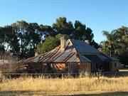
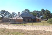
The following statement is taken from the State Register Entry for place 4015, Day Cottage. Day Cottage, a colonial vernacular cottage with limestone masonry walls and shingle clad roof covered in corrugated iron, together with two outbuildings, windmill, tankstand and a number of mature plantings, has cultural heritage significance for the following reasons: • the place is a rare example of a dwelling dating to the colonial period of Western Australia, which has been preserved in a highly authentic state and in a structurally sound condition; • the construction of the cottage is of technical interest as an example of construction methods employed in the mid to late nineteenth century in rural areas in Western Australia. Of particular interest are the planning of the building, the type of masonry employed and the intact shingle roof; • the place is an important component of the collection of extant colonial buildings at East Rockingham; • the place is one of the older established properties in the locality, and has social value because of its long-standing association with the Day family who were prominent in local social and civic affairs; and, • the place is recognised as having aesthetic value, and over the past three decades has been a favourite subject of artists and photographers.
A Victorian vernacular single storey rendered limestone and iron cottage. The place has fallen into disrepair but retains much of its original design intent. The core of the house has a high hipped roof with rendered corbelled chimneys, the roof pitch breaks at eaves level becoming shallower over the two side wings. The skillion verandah across the recessed section of the façade has partially been lost with the timber structure remaining extant, though in poor condition, whilst most of the iron cladding sheets have been lost. The timber framing to the windows remains extant in most openings but the glazing has been broken or lost. The north elevation contains a stone chimney projecting out from the north wall adjoining a section of the house constructed from timber framing with fibre cement cladding and louvered openings. The north west corner of the place has a separate hipped roof but is attached to the main part of the house. The outbuildings including a former kitchen, an out- house, a laundry, a well, a windmill and a tank stand to the rear of the place are in variable condition. The windmill appears to have been lost.
The land on which this cottage is located was originally owned by Jabez White. It is believed that a small cottage was built on this site before William and Susan (nee Hymus) Day leased 40 acres of land at Cockburn Sound Location 72 in c1858. William Day was a relative of Jabez White. Susan Day had come to the district around 1855 when her brother William Hymus had acquired land at Location 44 and established a home for his mother, and brothers and sisters. Susan (1836-1929) and William (1835-1917) married on 21 April 1857, and two children, Sarah Ann and James, were born before the family settled on their East Rockingham land. The home they built there was a stone cottage constructed near the Mandurah Road. As the Day family expanded between 1857 and 1882, fifteen children were born and another stone shed was constructed behind the first. Between 1882 and 1885, William with the help of his sons and a stonemason, built the main homestead in front of the two earlier structures and named the place Ellendale. In 1895-6, Day converted Ellendale into the ‘Rockingham Inn’, although this venture was short lived. In 1897, Day became one of the founding members of the Rockingham Roads Board. In 1901, the land was transferred to the three youngest sons and William and Susan moved to Fremantle. From around 1919, there were various owners and occupiers of the Day property George John, 1919-1920; then Mary Ellen John until 1937; the WA Trustee, 1938-39; Ada Orwin (later Ada Lane), 1942-48; and George and Annie Orwin until 1951. In that year, the place was sold to Francis and Vida McClure. All of these owners were members of the White Family. In 1962, the property was purchased by Len and Mavis Pike. The Pikes also acquired additional land adjacent to the property and a new home and stables were built just north of Ellendale. Horse stables and a thorough bred training track was established by the Pikes. Ellendale has been unoccupied for many years and has deteriorated.
Integrity: Moderate Degree Authenticity: High Degree
Poor
| Ref ID No | Ref Name | Ref Source | Ref Date |
|---|---|---|---|
| State Heritage Office | |||
| Rockingham District Historical Society | |||
| City of Rockingham Municipal Heritage Investory | |||
| Ellendale (Day Cottage) Conservation Plan | |||
| Landgate Aerial Photos |
| Reserve | Lot/Location | Plan/Diagram | Vol/Folio |
|---|---|---|---|
| 1 | 37651 |
| Owner | Category |
|---|---|
| ME Pike | Other Private |
This information is provided voluntarily as a public service. The information provided is made available in good faith and is derived from sources believed to be reliable and accurate. However, the information is provided solely on the basis that readers will be responsible for making their own assessment of the matters discussed herein and are advised to verify all relevant representations, statements and information.
Dixon Rd Rockingham
Rockingham
Metropolitan
Constructed from 1994
| Type | Status | Date | Documents |
|---|---|---|---|
| (no listings) |
| Type | Status | Date | Documents |
|---|---|---|---|
| (no listings) |
| Type | Status | Date | Grading/Management | |
|---|---|---|---|---|
| Category | ||||
| Fire & Rescue Service Heritage Inventory | Adopted | 30 Aug 1997 | ||
Individual Building or Group
| Epoch | General | Specific |
|---|---|---|
| Present Use | GOVERNMENTAL | Fire Station |
| Original Use | GOVERNMENTAL | Fire Station |
| General | Specific |
|---|---|
| SOCIAL & CIVIC ACTIVITIES | Community services & utilities |
This information is provided voluntarily as a public service. The information provided is made available in good faith and is derived from sources believed to be reliable and accurate. However, the information is provided solely on the basis that readers will be responsible for making their own assessment of the matters discussed herein and are advised to verify all relevant representations, statements and information.
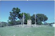
1 Empress Cnr Rockingham
Lot 304 (cnr Flinders L & Empress Cnr)
Rockingham
Metropolitan
Constructed from 1976
| Type | Status | Date | Documents |
|---|---|---|---|
| (no listings) |
| Type | Status | Date | Documents |
|---|---|---|---|
| (no listings) |
| Type | Status | Date | Grading/Management | |
|---|---|---|---|---|
| Category | ||||
| Municipal Inventory | Adopted | 25 Mar 2008 | Category E | |
| Statewide War Memorial Survey | Completed | 01 May 1996 | ||
Historic site
| Epoch | General | Specific |
|---|---|---|
| Present Use | MONUMENT\CEMETERY | Monument |
| Original Use | MONUMENT\CEMETERY | Monument |
| Type | General | Specific |
|---|---|---|
| Other | METAL | Other Metal |
| Other | BRICK | Common Brick |
| Other | STONE | Granite |
| General | Specific |
|---|---|
| SOCIAL & CIVIC ACTIVITIES | Community services & utilities |
| OUTSIDE INFLUENCES | World Wars & other wars |
This information is provided voluntarily as a public service. The information provided is made available in good faith and is derived from sources believed to be reliable and accurate. However, the information is provided solely on the basis that readers will be responsible for making their own assessment of the matters discussed herein and are advised to verify all relevant representations, statements and information.
Constructed from 1976
The site has historic value for its association with the social and community events enjoyed by the community in the period from 1976 to 2007 when the district was undergoing rapid change.
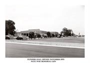
The block bounded by Kent Street, Flinders Lane, Smythe Street and Wanliss Street was occupied by the racetrack, cricket grounds and Agricultural Hall until the late 1950s as a site of community facilities. Following the rapid expansion of Rockingham which took place in the 1970s, Rockingham Park Shopping Centre expanded and became the sub-regional centre of the area. Flinder’s Hall was built in 1970 near to the shopping centre, on the site of the former cricket pitch. Flinders’s Hall was a single storey brick and tile community hall building, with a simple rectilinear form and distinctive low-pitched hip roof. A large entry porch extended from the southeast side of the hall, and a formal colonnade was across the southwest (front) elevation opening from the main hall into the gardens. The hall was demolished in 2007. The Flinder’s Hall gardens were once a large open grassed area, bordered by mature eucalypts and interspersed with a variety of other mature trees including a number of Norfolk pines. The Memorial Rose Garden was the centrepiece of the garden and this was cleared as part of the development of the site. The War Memorial was located on the southeast side of the hall. It was relocated in 2007 to the south west side of Flinders Lane opposite its original location.
| Owner | Category |
|---|---|
| City of Rockingham | Local Gov't |
This information is provided voluntarily as a public service. The information provided is made available in good faith and is derived from sources believed to be reliable and accurate. However, the information is provided solely on the basis that readers will be responsible for making their own assessment of the matters discussed herein and are advised to verify all relevant representations, statements and information.
end of Fisher St, Palm Beach, Mangles Bay Rockingham
Fisher Street Jetty
Naval Jetty (Site of)
Pine Beach Jetty
Rockingham
Metropolitan
Constructed from 1968
| Type | Status | Date | Documents |
|---|---|---|---|
| (no listings) |
| Type | Status | Date | Documents |
|---|---|---|---|
| RHP - Does not warrant assessment | Current | 10 Oct 2008 |
| Type | Status | Date | Grading/Management | |
|---|---|---|---|---|
| Category | ||||
| Municipal Inventory | Adopted | 24 Apr 2018 | Category E | |
16809 Palm Beach Precinct
| Name | Type | Year From | Year To |
|---|---|---|---|
| Royal Australian Navy | Architect | - | - |
Historic Site
| Epoch | General | Specific |
|---|---|---|
| Original Use | Transport\Communications | Water: Jetty |
This information is provided voluntarily as a public service. The information provided is made available in good faith and is derived from sources believed to be reliable and accurate. However, the information is provided solely on the basis that readers will be responsible for making their own assessment of the matters discussed herein and are advised to verify all relevant representations, statements and information.
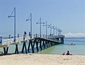
Constructed from 1944
• The site has historic value for its association with the former jetty at this site which was built by the Navy for their use during World War II and in the following decades. • The site has social value for the members of the community who used the former jetty at this site for a variety of recreational pursuits.
Palm Beach Jetty was demolished c.2008 with the current jetty being constructed in 2010 in the same position. Interpretation has been added at the entrance to the jetty commemorating the Z Force Memorial which is housed on Garden Island. Reference is also made to the former Palm Beach Jetty by continuance of the name in the current jetty.
In the early decades of the 20th century there was a small private jetty on this site for the settlers in the area. In 1944, the Navy who were based on Garden Island constructed a new jetty on the site to replace the jetty. The new structure was built of timber and concrete piles and extended 365 feet from the shore, with an L-shaped extension 350 feet long and 34 feet wide. At the junction of the two elements of the jetty was a two storey hut. The jetty was used as a mooring place for RAAF Corvettes, and later, used as a mooring for North West whaling boats during their off-season. The jetty was later used by ferries taking passengers and supplies to Garden Island. By the late 1960s the condition of the extension was poor and it was reduced in size and the hut removed. This smaller jetty structure remained insitu until late 2008 when all evidence of the structure was removed. In 2009, the current [2017] was built at the same location and is known as the Palm Beach Jetty.
Integrity: None Authenticity: None
| Reserve | Lot/Location | Plan/Diagram | Vol/Folio |
|---|---|---|---|
| 444 | 22779 |
| Owner | Category |
|---|---|
| Department for Planning and Infrastructure | State Gov't |
| Dept of Planning and Infrastructure (coastal) | State Gov't |
| City of Rockingham | Local Gov't |
This information is provided voluntarily as a public service. The information provided is made available in good faith and is derived from sources believed to be reliable and accurate. However, the information is provided solely on the basis that readers will be responsible for making their own assessment of the matters discussed herein and are advised to verify all relevant representations, statements and information.
153 Esplanade Rockingham
Lot 1 on Strata Plan 25819
Esplanade Flats
Rockingham
Metropolitan
Constructed from 1964
| Type | Status | Date | Documents |
|---|---|---|---|
| Heritage List | Adopted | 24 Apr 2018 |
| Type | Status | Date | Documents |
|---|---|---|---|
| (no listings) |
| Type | Status | Date | Grading/Management | |
|---|---|---|---|---|
| Category | ||||
| Municipal Inventory | Adopted | 14 Dec 2010 | Category B | |
| Name | Type | Year From | Year To |
|---|---|---|---|
| Julius Elischer | Architect | - | - |
Individual Building or Group
| Epoch | General | Specific |
|---|---|---|
| Present Use | RESIDENTIAL | Flats\Apartment Block |
| Original Use | RESIDENTIAL | Flats\Apartment Block |
This information is provided voluntarily as a public service. The information provided is made available in good faith and is derived from sources believed to be reliable and accurate. However, the information is provided solely on the basis that readers will be responsible for making their own assessment of the matters discussed herein and are advised to verify all relevant representations, statements and information.
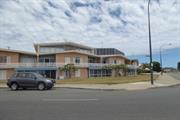
Constructed from 1964
• The place has aesthetic value as a good, intact example of an apartment complex designed in the 1960s which reflects the stylistic elements of the period. • The place has historic value for its association with the ongoing development of Rockingham as a tourist destination as this form of accommodation was new to the town and responded to a changing clientele. • The place has historic value for its association with well-known and innovative architect, Julius Elischer who made a significant contribution to the architecture profession in Western Australia.
Triple storey pale brick apartment complex constructed on a prominent corner site. The building contains a number of shallow pitched gable roofs which creates a distinctive roofscape to this part of the Esplanade/Val Street. The design of the building incorporates a curved façade responding to the corner position of the structure. The third storey of the complex is limited to the centre of the building creating a stepped height to the apartments. The third story is predominantly glass to the main elevation. The second storey to the four blocks all consist of alternating flush facades and balconies joined together by a continuous timber balustrade. The ground level consists of alternating glazed entrances and traditional window openings in brick walls. The windows all have shutters.
This apartment complex was built in 1964 by architect, Julius Elischer (1918-2004). Julius Elischer was born in Budapest and grew up in Austria, Hungary and Germany. After working as an architect in post-war Germany he emigrated to Melbourne before moving to Perth in 1957. Elischer established his architectural office in 1963, and developed a reputation for producing designs that could be economically built to a high standard. He designed many local civic buildings, churches, schools and retirement villages in Western Australia and had a special interest in low cost building materials. He invented roofing systems from coils of metal and Styrocon, a lightweight sandwich building panel, used extensively in outback WA. Elischer’s buildings reflect his strong belief that responsible architecture should attempt to fit into its built surroundings. During the 1970s he lectured in design at the University of Western Australia. He retired in 1986 and died in February 2004. This apartment complex was named Esplanade Flats in the drawings prepared in Elischer's office, the name 'Carinya', an indigenous name meaning resting place according to some references seems to have been in use since its opening. The complex continues to be used for holiday accommodation. Aerial photographs indicate that the residence has not changed significantly in form or extent since its construction.
Integrity: High Authenticity: High
Good
| Name | Type | Year From | Year To |
|---|---|---|---|
| Julius Elischer | Architect | 1964 | - |
| Ref ID No | Ref Name | Ref Source | Ref Date |
|---|---|---|---|
| City of Rockingham Municipal Heritage Investory | September 2012 | ||
| 7097A/6/6 | Landgate Land Information and aerial photographs |
| Owner | Category |
|---|---|
| Multiple | Other Private |
This information is provided voluntarily as a public service. The information provided is made available in good faith and is derived from sources believed to be reliable and accurate. However, the information is provided solely on the basis that readers will be responsible for making their own assessment of the matters discussed herein and are advised to verify all relevant representations, statements and information.
Flinders Lane Rockingham
The Site of Racecourse is located on the north-east side of the current Rockingham Oval.
Rockingham
Metropolitan
| Type | Status | Date | Documents |
|---|---|---|---|
| (no listings) |
| Type | Status | Date | Documents |
|---|---|---|---|
| (no listings) |
| Type | Status | Date | Grading/Management | |
|---|---|---|---|---|
| Category | ||||
| Municipal Inventory | Adopted | 14 Dec 2010 | Category E | |
Historic Site
| Epoch | General | Specific |
|---|---|---|
| Original Use | SOCIAL\RECREATIONAL | Other |
This information is provided voluntarily as a public service. The information provided is made available in good faith and is derived from sources believed to be reliable and accurate. However, the information is provided solely on the basis that readers will be responsible for making their own assessment of the matters discussed herein and are advised to verify all relevant representations, statements and information.
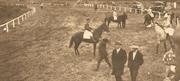
The site has historic value for its association with the social and sporting events enjoyed by the local community in the Inter War period. This association is continued in the current use of the site as a sportsground.
The site of the former Racecourse was on the north-east side of the current Rockingham Oval, across Flinders Lane. It was bounded by Kent Street and Wanliss Street on the northern side and Flinders Lane and Emma Street to the south. Most of the former racecourse site is now occupied by sports facilities.
In the 1930s, there were fewer visitors in the Rockingham area after the holiday season in the summer. The local residents were able to enjoy the local recreational facilities instead of catering for the seasonal visitors. Some local residents enjoyed horse racing and occasional meetings were held at the Rockingham Oval. The course ran around the cricket pitch, where Flinders Hall used to stand, and it finished in front of Kent Street. The race meetings were well attended and many farmers entered their horses. The racing ground was also used for Agricultural Shows. In the late 1930s, when school sports were introduced, the place was used for school Sports Days.
| Ref ID No | Ref Name | Ref Source | Ref Date |
|---|---|---|---|
| Landgate Land Information and aerial photographs | |||
| City of Rockingham Municipal Heritage Investory | September 2012 |
This information is provided voluntarily as a public service. The information provided is made available in good faith and is derived from sources believed to be reliable and accurate. However, the information is provided solely on the basis that readers will be responsible for making their own assessment of the matters discussed herein and are advised to verify all relevant representations, statements and information.
Flinders Lane Rockingham
Rockingham
Metropolitan
| Type | Status | Date | Documents |
|---|---|---|---|
| (no listings) |
| Type | Status | Date | Documents |
|---|---|---|---|
| (no listings) |
| Type | Status | Date | Grading/Management | |
|---|---|---|---|---|
| Category | ||||
| (no listings) | ||||
Other Built Type
| Epoch | General | Specific |
|---|---|---|
| Original Use | Transport\Communications | Road: Other |
This information is provided voluntarily as a public service. The information provided is made available in good faith and is derived from sources believed to be reliable and accurate. However, the information is provided solely on the basis that readers will be responsible for making their own assessment of the matters discussed herein and are advised to verify all relevant representations, statements and information.
11 Florence St Rockingham
Cnr Parkin & Florence Sts Rockingham
Lutheran Church
Methodist Church
Rockingham
Metropolitan
Constructed from 1940
| Type | Status | Date | Documents |
|---|---|---|---|
| Heritage List | Adopted | 24 Apr 2018 |
| Type | Status | Date | Documents |
|---|---|---|---|
| (no listings) |
| Type | Status | Date | Grading/Management | |
|---|---|---|---|---|
| Category | ||||
| Municipal Inventory | Adopted | 25 Mar 2008 | Category B | |
| Library Id | Title | Medium | Year Of Publication |
|---|---|---|---|
| 9464 | Heritage report on East Rockingham settlement for City of Rockingham, Town of Kwinana and Landcorp. | Heritage Study {Other} | 0 |
Individual Building or Group
| Epoch | General | Specific |
|---|---|---|
| Present Use | RELIGIOUS | Church, Cathedral or Chapel |
| Original Use | RELIGIOUS | Church, Cathedral or Chapel |
| General | Specific |
|---|---|
| DEMOGRAPHIC SETTLEMENT & MOBILITY | Aboriginal Occupation |
This information is provided voluntarily as a public service. The information provided is made available in good faith and is derived from sources believed to be reliable and accurate. However, the information is provided solely on the basis that readers will be responsible for making their own assessment of the matters discussed herein and are advised to verify all relevant representations, statements and information.
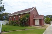
Constructed from 1940
• The place has aesthetic value as a simple expression of the Inter War Gothic style expressed in brick. • The place has historic value for its association with the establishment and development of the Methodist Church in the district. • The place has historic value for its associations with community members who contributed to the establishment of the church; George Grigg, J. Stone and Rev Jules Johnson. • The place has social value for the many members of the Rockingham community who have attended services or events at the church since 1940.
Inter-war single storey red brick and limestone church of traditional church vernacular comprising steep pitched gable roof clad in terracotta tiles and regularly placed arched windows along the side elevations positioned between the stepped buttresses and a small porch entry to the north elevation. The fibro addition to the rear was demolished in late 2013 with the current angled weatherboard and Colorbond addition constructed in late 2014. The cross remains extant on the north elevation above the porch.
The Methodist Church in Rockingham was the first church built in the town and was completed in 1940. Prior to the construction of the church the Methodist congregation had held services in local homes. Prominent local citizen, and Road Board Chairman, George Grigg donated two lots of land for the future church. Funds to build the church came from a generous donation from Mr J. Stone supplemented by fund raising by the Rockingham Methodist Ladies Guild. When the trustees for the Methodist Church called for tenders to construct the church in March 1940 they asked for alternate tenders; one in wood and asbestos and the other in brick and stone. By June 1940, the decision had been made to build the church in brick and a ceremony was held to lay the foundation stones on 22nd June. Two foundation stones were laid; one by the Lieutenant Governor Sir James Mitchell and the other by Mrs J.W. Morrison a long term resident and President of the Methodist Ladies Guild. A report in the local press stated that the church was estimated to cost £600 and would take ten weeks to build. On 28th September 1940, a ceremony was held to open the church which was described as a handsome brick church 40ft x 20ft and able to seat 300. The cost of construction was over £1000. The building was officially opened by Rev H. Pearson, president of the conference and an organ was presented to the church by Mr Downe of Claremont. The first pastor of the church was Rev Jules Johnstone who is believed to have forgone his stipend for the first two years of his term to assist in the payment of the costs of the construction. In 1946, a manse was built adjacent to the church and by the mid-1960s an addition was constructed on the rear of the church which featured a similar roof form in asbestos. Another addition was constructed on the western elevation of the church in the 1970s. The Uniting Church in Australia (UCA) was established on 22 June 1977 when most congregations of the Methodist Church of Australasia, about two thirds of the Presbyterian Church of Australia and the almost all churches of the Congregational Union of Australia came together under the Basis of Union. The name of the Rockingham Methodist Church changed to reflect this union. Aerial photographs indicate that the manse was demolished in mid-2016. The additions to the church were removed in early 2014 and a small addition was constructed on the rear of the church angled to this elevation. It is likely this approach was taken to accommodate subdivision of the lot.
Integrity: High Authenticity: High
Fair
| Reserve | Lot/Location | Plan/Diagram | Vol/Folio |
|---|---|---|---|
| 1 | 72683 |
| Owner | Category |
|---|---|
| Mr Mrs Saffers | Other Private |
This information is provided voluntarily as a public service. The information provided is made available in good faith and is derived from sources believed to be reliable and accurate. However, the information is provided solely on the basis that readers will be responsible for making their own assessment of the matters discussed herein and are advised to verify all relevant representations, statements and information.
Garden Island N of Rockingham
An island immediately to the north of Rockingham and connected to the mainland by a traffic bridge
Bauche Island
Meandip
Rockingham
Metropolitan
Constructed from 1801
| Type | Status | Date | Documents |
|---|---|---|---|
| Commonwealth List | YES | 22 Jun 2004 |
| Type | Status | Date | Documents |
|---|---|---|---|
| RHP - To be assessed | Current | 28 Sep 2007 |
| Type | Status | Date | Grading/Management | |
|---|---|---|---|---|
| Category | ||||
| Register of the National Estate | Permanent | 30 May 1995 | ||
| Classified by the National Trust | Classified {Lscpe} | 05 May 1994 | ||
The Cliff Point Historic Site, individually significant within the area of Garden Island is important as the first site inhabited by Governor Stirling's party in 1829 when founding the colony of Western Australia (WA), and as Western Australia's first official non-convict settlement. The site was occupied in the first instance by Captain Charles Fremantle before the arrival of Captain Stirling. The party occupied the site for two months before a move was made to the Swan River settlement on the mainland. The Cliff Point Historic Site is important as the site of first settlement in Western Australia. The Cliff Point Historic Site is highly valued by the community for its cultural associations. The Cliff Point Historic Site, also known as Sulphur Town, after HMS Sulphur was chosen in 1828 by Governor Stirling to transport settlers to the new colony and is important for its association with Governor Stirling and Captain Charles Fremantle.
Garden Island is comprised of a ridge of Tamala Limestone covered with calcareous sand. Limestone outcrops and intertidal rock platforms occur on the western and southern coastlines. The western side of the island is dominated by a series of parabolic dunes of the Quindalup soil unit, ranging in age from several hundred to 6000 years. The eastern side has a series of gently undulating benches.
Garden Island was first called Meeandip by the Aborigines and Ile de Buache by the French following the visit of Nicholas Baudin in 1801. Ile de Bauche was renamed Garden Island in 1829 by Captain Charles Fremantle. Rottnest, Carnac and Garden Islands have been separated from the mainland for about 6000 to 7000 years since the sea levels rose after the last Ice Age. Towards the end of 1826 Governor Darling sent Major Lockyer to secure the King George Sound area for the Crown. The garrison force included 18 troops, 23 convicts, a surgeon-assistant and others on board including the crew of the brig Amity. Major Lockyer was instrumental in freeing Aboriginal people who had been taken prisoner by sealers, the first Europeans to exploit the coastal regions of Western Australia. In 1827 Captain James Stirling visited the Swan River region reporting favourably on the mainland and Garden Island for their agricultural potential. Before returning to Britain, Stirling landed the remaining livestock from his ship on the island of 'Buache,' later renamed Garden Island by Captain Charles Fremantle.
| Library Id | Title | Medium | Year Of Publication |
|---|---|---|---|
| 8799 | HMAS Stirling : history and heritage. | Heritage Study {Other} | 0 |
Landscape
| Epoch | General | Specific |
|---|---|---|
| Original Use | RESIDENTIAL | Other |
| Present Use | MILITARY | Other |
| General | Specific |
|---|---|
| SOCIAL & CIVIC ACTIVITIES | Education & science |
| OCCUPATIONS | Fishing & other maritime industry |
| DEMOGRAPHIC SETTLEMENT & MOBILITY | Aboriginal Occupation |
| TRANSPORT & COMMUNICATIONS | River & sea transport |
| PEOPLE | Early settlers |
| DEMOGRAPHIC SETTLEMENT & MOBILITY | Settlements |
| OUTSIDE INFLUENCES | World Wars & other wars |
| PEOPLE | Famous & infamous people |
| PEOPLE | Aboriginal people |
This information is provided voluntarily as a public service. The information provided is made available in good faith and is derived from sources believed to be reliable and accurate. However, the information is provided solely on the basis that readers will be responsible for making their own assessment of the matters discussed herein and are advised to verify all relevant representations, statements and information.
Garden Island N of Rockingham
Rockingham
Metropolitan
| Type | Status | Date | Documents |
|---|---|---|---|
| Heritage List | Adopted | 01 Mar 2008 |
| Type | Status | Date | Documents |
|---|---|---|---|
| (no listings) |
| Type | Status | Date | Grading/Management | |
|---|---|---|---|---|
| Category | ||||
| Statewide War Memorial Survey | Completed | 01 May 1996 | ||
| Municipal Inventory | Adopted | 25 Mar 2008 | Category B | |
Historic site
| Epoch | General | Specific |
|---|---|---|
| Original Use | MONUMENT\CEMETERY | Monument |
| Present Use | MONUMENT\CEMETERY | Monument |
| Type | General | Specific |
|---|---|---|
| Other | STONE | Granite |
| General | Specific |
|---|---|
| OUTSIDE INFLUENCES | World Wars & other wars |
This information is provided voluntarily as a public service. The information provided is made available in good faith and is derived from sources believed to be reliable and accurate. However, the information is provided solely on the basis that readers will be responsible for making their own assessment of the matters discussed herein and are advised to verify all relevant representations, statements and information.
Aesthetic Value: The place is symmetrically designed with the stone memorial centrally located within a raised grassed plinth, which is flanked either side by flagpoles and set back from the road. Social Value: The place is associated with the ‘Z Force’ Reconaissance Division who trained on Garden Island during WWII, and commemorates their achievements and sacrifices during this period. The place is valued by the community as a memorial to the services of the ‘Z Force’ Reconaissance Division during WWII, and is complemented by another memorial located at Palm Beach on the mainland.
The Garden Island Z Force Memorial is located on the western side of Dampier Drive on a gently sloping grassed site with native bushland on three sides. The memorial comprises a random rubble stone pier, approximately 2.5m high and 1.5m high, raised on a grassed platform that is edged with a low stone wall and accessed by three brick paved steps. Flag poles are positioned either side of the memorial, which features a plaque commemorating the Services Reconaissance Department.
The Z-Force Memorial was erected on Garden Island as a memorial to the members of the Services Reconnaissance Department, also known as ‘Z- Force’. This unit, which was formed in 1942, trained on Garden Island during WWII. Z Force was the unofficial and popular name for Z Special Unit. It was one of Australia`s independent forces that operated behind enemy lines in the South-West Pacific during World War Two. Although it consisted of mainly Australian and British personnel, it also contained operatives from the various allied forces including China and resistance fighters from the Japanese conquered South Asian region. The Z Specials’ achievements on more than 80 operations into enemy-occupied territories in the Pacific and Southeast Asia theatres were classified for decades. This secret element of the Australian forces relied largely on the wits and initiative of individual soldiers from diverse backgrounds who often had little knowledge of the areas in which they were sent to operate. The original location of the memorial was closer to the beach, in an area where the Naval facilities were constructed and it was moved prior to the construction of HMAS Stirling to current location at the west side of Dampier Road.
Integrity: High Degree Authenticity: High Degree
Good
| Reserve | Lot/Location | Plan/Diagram | Vol/Folio |
|---|---|---|---|
| C/T:41/79 | 9 | 226190 |
This information is provided voluntarily as a public service. The information provided is made available in good faith and is derived from sources believed to be reliable and accurate. However, the information is provided solely on the basis that readers will be responsible for making their own assessment of the matters discussed herein and are advised to verify all relevant representations, statements and information.
Hefron St Rockingham
Rockingham
Metropolitan
Constructed from 1972
| Type | Status | Date | Documents |
|---|---|---|---|
| Heritage List | Adopted | 24 Apr 2018 |
| Type | Status | Date | Documents |
|---|---|---|---|
| (no listings) |
| Type | Status | Date | Grading/Management | |
|---|---|---|---|---|
| Category | ||||
| Municipal Inventory | Adopted | 24 Apr 2018 | Category C | |
| Fire & Rescue Service Heritage Inventory | Adopted | 30 Aug 1997 | ||
Individual Building or Group
| Epoch | General | Specific |
|---|---|---|
| Original Use | GOVERNMENTAL | Fire Station |
| Present Use | GOVERNMENTAL | Fire Station |
| General | Specific |
|---|---|
| SOCIAL & CIVIC ACTIVITIES | Community services & utilities |
This information is provided voluntarily as a public service. The information provided is made available in good faith and is derived from sources believed to be reliable and accurate. However, the information is provided solely on the basis that readers will be responsible for making their own assessment of the matters discussed herein and are advised to verify all relevant representations, statements and information.
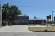
Constructed from 1972
•the place has aesthetic value as a simple demonstration of the late 20th century style executed in brick. •the place has historic value for its association with the growth of the region in the 1970s. •the place has social value for its provision of a range of services to the community from fire station to youth services.
A single storey painted brick and rendered building with a corrugated metal roof set back from the street with a large double driveway and front yard area. The lower station house portion of the building has modest sized screened windows on plain facades and a gabled roof. The fire engine and equipment side has a hipped roof. The two openings that once accommodated the entry and exit of fire engines between the building and the street have been filled in and now each contain a set of three screened windows. The piers and lintels surrounding these openings remain.
This building was constructed in 1972 as the fire station for Rockingham and districts. With the growth of the region in the late 20th century it became apparent that the fire station services were inadequate for the region. A new fire station was built in Dixon Road c1990 and that facility continues to provide for the community. This facility is now managed by the City of Rockingham which adapted the building in 1998 as a Youth Centre to provide services for the community. Amongst their services the Station Youth Centre provides free and confidential services to young people aged between 12 and 24. Services for young people include support, information, advocacy, referrals, groups and programs from the duty system.
Contributes to the heritage of the locality. Has some altered or modified elements, not necessarily detracting from the overall significance of the item.
Good
| Reserve | Lot/Location | Plan/Diagram | Vol/Folio |
|---|---|---|---|
| 393 | 60465 |
This information is provided voluntarily as a public service. The information provided is made available in good faith and is derived from sources believed to be reliable and accurate. However, the information is provided solely on the basis that readers will be responsible for making their own assessment of the matters discussed herein and are advised to verify all relevant representations, statements and information.
63-65 Kent Rockingham
Lots 2 and 201 on Diagrams 090163 and 076412
St Nicholas Church
Rockingham
Metropolitan
Constructed from 1946
| Type | Status | Date | Documents |
|---|---|---|---|
| Heritage List | Adopted | 24 Apr 2018 |
| Type | Status | Date | Documents |
|---|---|---|---|
| (no listings) |
| Type | Status | Date | Grading/Management | |
|---|---|---|---|---|
| Category | ||||
| Municipal Inventory | Adopted | 25 Mar 2008 | Category B | |
| Library Id | Title | Medium | Year Of Publication |
|---|---|---|---|
| 9464 | Heritage report on East Rockingham settlement for City of Rockingham, Town of Kwinana and Landcorp. | Heritage Study {Other} | 0 |
Individual Building or Group
| Epoch | General | Specific |
|---|---|---|
| Original Use | RELIGIOUS | Church, Cathedral or Chapel |
| Present Use | RELIGIOUS | Church, Cathedral or Chapel |
This information is provided voluntarily as a public service. The information provided is made available in good faith and is derived from sources believed to be reliable and accurate. However, the information is provided solely on the basis that readers will be responsible for making their own assessment of the matters discussed herein and are advised to verify all relevant representations, statements and information.
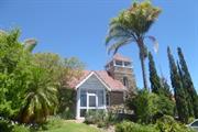
Constructed from 1945
• The place has aesthetic value as a landmark in the town and for its rock-faced stone walls, steeply-pitched gable roof forms, and its dominant square tower in the Inter War Romanesque style. • The place has historic value for its association with Reverend Thomas Purdy, the first Anglican rector of the Rockingham/Spearwood district. • The place has historic value for its association with the Ladies Guild who campaigned and fundraised for the construction of the church. • The place has social value for the community as a venue for religious congregation and worship from 1945 to 1990.
A former church building that has been adapted for new use whilst retaining the original design intent of the building. The church is positioned in a prominent and elevated position on the corner of Kent Street and Wanliss Street, set back a distance from Kent Street behind gardens and parking areas. The building is of stone construction with distinctive tower which terminates in a prominent Marseilles tiled roof with timber framed openings immediately below. The former church building is constructed with local limestone laid in coursed rubble. The main body of the church has a steeply pitched gable roof. A centrally placed porch with glazed walls and steep pitched gable roof provides entry into the building. A large addition to the rear cannot be seen from the main elevation.
In 1934, Reverend Thomas Purdy was appointed Rector of the newly formed parish of Rockingham/Spearwood and took up his residence in Rockingham, although at that time there was no church. A Ladies’ Guild was formed in Rockingham, and through their efforts and those of Reverend Purdy, the Church of St Nicholas was built on the corner of Kent and Wanliss Streets. The architect and builder of the church have not been determined. The church was consecrated on 12th May 1945 by Archbishop of Perth Dr Henry Frewen Le Fanu on 16 December 1945. The local press described the building as follows: Built of local stone on a rise at the back of the township, the building is an imposing one. The interior is finished in plain jarrah which tones in with the surroundings. The cost of the completed work was £1,300, most of which was raised in the district. In the early 1960s, a large extension was added to the rear of the church on the south east elevation which was roofed in asbestos. The church was sold in 1979 and a new church, bearing the same name, was erected in Council Avenue for the Anglican Church. The former St Nicholas's Church was subsequently used as a church for the Salvation Army and dedicated by Colonel Roy Lovatt on 31st August 1980. A new entry porch was added in this period on the north west elevation. The building was subsequently sold and has been used as a dentist surgery since 1990.
Integrity: Moderate Degree Authenticity: High Degree
Good
| Reserve | Lot/Location | Plan/Diagram | Vol/Folio |
|---|---|---|---|
| 2 | 90163 | ||
| 201 | 90163 |
This information is provided voluntarily as a public service. The information provided is made available in good faith and is derived from sources believed to be reliable and accurate. However, the information is provided solely on the basis that readers will be responsible for making their own assessment of the matters discussed herein and are advised to verify all relevant representations, statements and information.
Kent St Rockingham
Nearest cross street, Flinders Lane
Rockingham
Metropolitan
| Type | Status | Date | Documents |
|---|---|---|---|
| Heritage List | YES | 14 Dec 2010 |
| Type | Status | Date | Documents |
|---|---|---|---|
| RHP - Does not warrant assessment | Current | 28 Oct 2005 |
| Type | Status | Date | Grading/Management | |
|---|---|---|---|---|
| Category | ||||
| Municipal Inventory | Adopted | 22 Dec 1998 | Category C | |
02321 Rockingham Hotel
Historic site
| Epoch | General | Specific |
|---|---|---|
| Original Use | OTHER | Other |
| Present Use | OTHER | Other |
| Type | General | Specific |
|---|---|---|
| Wall | OTHER | Other Material |
This information is provided voluntarily as a public service. The information provided is made available in good faith and is derived from sources believed to be reliable and accurate. However, the information is provided solely on the basis that readers will be responsible for making their own assessment of the matters discussed herein and are advised to verify all relevant representations, statements and information.
Aesthetic Value: the walls form an attractive accessway between Kent Street and Rockingham Beach the trees form a well-known landmark and are visible from both Kent Street and Rockingham Beach Road Historic Value: the walls are constructed of the local limestone, originally quarried from the East Rockingham district and used to build a large number of early structures throughout Rockingham the place is associated with Reg Grigg (from the hotel) and Ted Lewington (from the Roads Board) who were credited with planting the trees, as well as a number of the trees in front of the hotel Social Value: the place is valued by the community as a long-standing and popular site of social and recreational activity, and as the remains of once extensive public gardens the trees are valued by the community for their association with the development of Rockingham in the 1940s into a popular resort, and with the Rockingham Hotel and its surrounding gardens which were the focus of social activities
Random rangework stone walling, comprising lower sections of wall separated by regularly spaced square stone piers, approximately 1700mm high. The westernmost section of wall, closest to the hotel also has tubular steel balustrading. The walls form an accessway between Kent Street and Rockingham Beach Road, and also define the edges of the hotel beer garden. Four Norfolk pine trees (Araucaria heterophylla), each approximately 30m high, located to the east of the Rockingham Hotel. Three of the trees are grouped near Kent Street, and are part of the hotel’s beer garden. The other tree is located at the northern end of the hotel walls which extend towards Rockingham Beach Road. The four trees are visible from both Kent Street and Rockingham Beach Road and combine with the Rockingham Hotel to form a well-known landmark.
The four Norfolk Island pine trees comprise the only remaining plantings of what was a well-used and admired garden at the Rockingham Hotel.
High
Good
| Reserve | Lot/Location | Plan/Diagram | Vol/Folio |
|---|---|---|---|
| 99 | 88032 |
| Owner | Category |
|---|---|
| Mirco Bros Pty Ltd | Other Private |
This information is provided voluntarily as a public service. The information provided is made available in good faith and is derived from sources believed to be reliable and accurate. However, the information is provided solely on the basis that readers will be responsible for making their own assessment of the matters discussed herein and are advised to verify all relevant representations, statements and information.
Kent St Rockingham
Rockingham
Metropolitan
Constructed from 1950, Constructed from 1930
| Type | Status | Date | Documents |
|---|---|---|---|
| (no listings) |
| Type | Status | Date | Documents |
|---|---|---|---|
| (no listings) |
| Type | Status | Date | Grading/Management | |
|---|---|---|---|---|
| Category | ||||
| Municipal Inventory | Adopted | 24 Apr 2018 | Category E | |
Historic Site
| Epoch | General | Specific |
|---|---|---|
| Present Use | COMMERCIAL | Other |
| Original Use | SOCIAL\RECREATIONAL | Theatre or Cinema |
This information is provided voluntarily as a public service. The information provided is made available in good faith and is derived from sources believed to be reliable and accurate. However, the information is provided solely on the basis that readers will be responsible for making their own assessment of the matters discussed herein and are advised to verify all relevant representations, statements and information.
Constructed from 1930, Constructed from 1950
• The site has historic value for its association with the provision of entertainment during the Inter War period for holiday makers and local residents. • The site has social value for the members of the community who recall and attended events at the theatres in the mid-20th century.
The former theatres were located in the vicinity of Rockingham Hotel in Kent Street. The site has been redeveloped with no extant evidence of the former use.
During the Inter War period Rockingham was a popular holiday destination. Outdoor Picture Theatres were popular from the 1930s through to the 1950s. The Cabaret which was also known as the Jazz Hall was built to the south of the Rockingham Hotel in c. 1920s. It was first used as a dance hall by licensees, the Harrisons and Griggs and then became the venue for moving pictures in Rockingham. Throughout the 1930s and 1940s Syd Hart and his wife ran the Theatre and later by Mr McGrath. In c. 1940, Jack Bidstrup who leased Mandogalup Hall in Safety Bay, used it as picture theatre named Bay View Theatre. It was showing films in opposition to the theatre in Rockingham and both occasionally showed the same films by swapping reels every half time. In c. 1944, Harry Delevale took over Rockingham Hotel and built an open-air theatre next to the hotel where the tennis courts were located. In the late 1940s, an open-air theatre was built a few blocks south of the hotel towards Railway Terrace on a site sloping towards the screen at seaward end. It was less sheltered and patrons were watching films in the cold during winter nights. In the 1950s, a purpose built theatre called the ‘Century Gardens’ was constructed at the corner of Railway Terrace and Kent St. It was managed by Jack and Maureen Bidstrup who were also managing Bay View Theatre.
This information is provided voluntarily as a public service. The information provided is made available in good faith and is derived from sources believed to be reliable and accurate. However, the information is provided solely on the basis that readers will be responsible for making their own assessment of the matters discussed herein and are advised to verify all relevant representations, statements and information.
26 Kent St Rockingham
This place is part of the larger P17865 Rockingham Hotel Site. The hotel was part of a much larger recreational site that occupied the whole block.
Port Hotel (fmr)
Rockingham
Metropolitan
Constructed from 1898 to 1957
| Type | Status | Date | Documents |
|---|---|---|---|
| Heritage List | Adopted | 24 Apr 2018 | |
| State Register | Removed | 07 Jun 2011 | HCWebsite.Listing+ListingDocument |
| Type | Status | Date | Documents |
|---|---|---|---|
| RHP - Does not warrant assessment | Current | 27 Oct 2023 |
| Type | Status | Date | Grading/Management | |
|---|---|---|---|---|
| Category | ||||
| Statewide Hotel Survey | Completed | 01 Nov 1997 | ||
| Municipal Inventory | Adopted | 24 Oct 1995 | Category A | |
17865 Rockingham Hotel Site
Fair to poor.
| Name | Type | Year From | Year To |
|---|---|---|---|
| William Bennet and Associates, extensions 1957 | Architect | - | - |
| W. G. Bennett, remodelling 1930s | Architect | - | - |
| Library Id | Title | Medium | Year Of Publication |
|---|---|---|---|
| 9598 | Levels of significance and policy statements: Rockingham Hotel (Port Hotel P2321), 28 Kent St, Rockingham. | Heritage Study {Other} | 2010 |
| 9464 | Heritage report on East Rockingham settlement for City of Rockingham, Town of Kwinana and Landcorp. | Heritage Study {Other} | 0 |
| 12005 | Rockingham Hotel Heritage & Townscape assessment | Heritage Study {Other} | 2007 |
Individual Building or Group
| Epoch | General | Specific |
|---|---|---|
| Original Use | COMMERCIAL | Hotel, Tavern or Inn |
| Present Use | COMMERCIAL | Hotel, Tavern or Inn |
| Style |
|---|
| Federation Arts and Crafts |
| Federation Filigree |
| Inter-War Functionalist |
| Type | General | Specific |
|---|---|---|
| Wall | STONE | Local Stone |
| Wall | BRICK | Rendered Brick |
| Roof | TILE | Ceramic Tile |
| General | Specific |
|---|---|
| SOCIAL & CIVIC ACTIVITIES | Sport, recreation & entertainment |
| OCCUPATIONS | Hospitality industry & tourism |
| Infrastructure | Development Settlements & Services |
| Peopling WA | Demographic development |
| DEMOGRAPHIC SETTLEMENT & MOBILITY | Settlements |
This information is provided voluntarily as a public service. The information provided is made available in good faith and is derived from sources believed to be reliable and accurate. However, the information is provided solely on the basis that readers will be responsible for making their own assessment of the matters discussed herein and are advised to verify all relevant representations, statements and information.
Constructed from 1989, Constructed from 1952, Constructed from 1946, Constructed from 1994, Constructed from 1898, Constructed from 1967, Constructed from 1925, Constructed from 1957, Constructed from 1936
he following statement is adapted from the documentation prepared for its removal from the State Register of Heritage Places in 2011. Rockingham Hotel, comprising a two-storey limestone, brick, tile and iron hotel, limestone walls of the former beer garden, and mature Norfolk Island Pines, has cultural heritage significance for the following reasons: • the place is the last remnant of a once extensive seaside resort, and has been an important location for social gathering, entertainment and holidays since the 1890s, particularly for farming and working-class families, and contributes to the local and wider community’s sense of place; • the place is important for its association with settler families of the district including Bell, Hymus and Grigg; • the place has landmark value, due to its prominence on the Rockingham foreshore; • the place has been partially constructed in honeycomb (vuggy) limestone from the ‘karst’ landscape endemic to the East Rockingham area which is a rare building material; • alterations to the Hotel demonstrate the changing nature and requirements of hotels from the 1890s to present day, facilitating a decline in the provision of accommodation and an increase in tavern trade; and, • the place is representative of the type of buildings and facilities considered appropriate for a seaside hotel complex in the 1930s.
Rockingham Hotel comprises a two-storey limestone building with a hipped corrugated iron roof, which faces Kent Street and a single-storey rendered brick and tile building at- tached to the northern side. The original timber-framed hotel building is no longer extant. The two-storey component was constructed in the 1890s and extended in 1924. It has French doors with fanlights above, opening to small canter livered balconies on the street facing portion of the first floor. The roof eaves overhang to provide some protection to the balconies. It has been rendered and painted and its timber verandah has been removed. The single storey component was constructed in 1924 and extensively remodelled in 1938. It has a series of regularly placed windows in sets of three with a single pane arched fanlight above, facing the carpark. The glazed double entry door on the same façade has a matching single pane arched fanlight. Between the carpark and the building is an alfresco area that is set behind a rendered pier and panel fence with glass infill panels, raised four steps from ground level. This part of the building has a curved corner to the northeast where it turns back to meet the two storey building. Further internal refurbishment took place in the 1950s and 1960s. (The restaurant and toilet extension to the rear of the single storey section is not significant.)
The construction of a jetty at Rockingham allowed the shipment of sandalwood, as well as jarrah. In 1875, for example, of the eighteen vessels that called at Rockingham, nine loaded sandalwood, five loaded jarrah railway sleepers for South Australia, and four other vessels put into Careening Bay (on the south east corner of Garden Island) for repairs. Over the next few years trade increased further, with a valuable export market in railway sleepers for India opening up. Between 1878 and 1883, at least half of the timber exported from Western Australia was shipped from Rockingham. During this time, ships also started to take on coal near Rockingham, with a coaling hulk established in Careening Bay- which was much safer for loading than Fremantle- with coal imported from Newcastle (N.S.W.). By 1903 the port was no longer exporting timber and Rockingham became a seaside town frequented by holiday makers from around Western Australia. In 1875, Daniel Hymus acquired Rockingham Town Lot 12, the future location of Rockingham Hotel. Daniel Hymus was married to Fanny Bell, and both families were amongst the first settlers of the East Rockingham Area. The original Port Hotel is believed to have been built on Lot 12 by Fanny’s brother, James Bell Jnr, in 1886. Daniel, Fanny and James Bell all remained associated with the management of the hotel in its early years. When first hotel was built, it was apparently a single storied wooden building, facing the sea, built on a slope with a long flight of steps leading to the bar. By 1898, with obvious confidence in the future of Rockingham, Daniel and Fanny Hymus had added a new two-storey stone section, with a timber verandah, to the front of the original timber hotel. This building, with modifications remains fronting Kent Street and contains the Saloon Bar. By 1902, Rockingham Port ceased to operate for timber exports although holidaymakers still often arrived by boat rather than by means of bush tracks. In 1918, Daniel Hymus, leased the Rockingham Hotel to Mr L.D. Hicks, who operated the premises as the Peron Hotel (after Point Peron). In 1922, the Rockingham Hotel was bought by Reginald Harrison, who was the then owner of the Criterion Hotel in Perth. Struggling since the port closure, by the 1920s the economic climate of Rockingham was to start looking up, mainly driven by the growing use of motorcars. With the car, Rockingham became more accessible. Particularly as it was far enough away from the metropolitan area that it qualified for Sunday drinking sessions, which were not permitted in the city. The Rockingham Hotel was also a significant draw as it was developed by Harrison as the centre of Rockingham as a fashionable, high class seaside resort, famous for its beaches, bathing, fishing and drinking. Harrison instigated an extensive program of improvements to the building and grounds. By the late 1920s, the Rockingham Hotel had undergone substantial alterations and additions, giving it the appearance of a Federation Arts and Crafts style building. Harrison had built an extension to the front northern end to provide a small upstairs lounge, entered through a new porch, as well as an extension to the bar on the ground floor. In 1925, Harrison sold Rockingham Hotel to a friend, George Grigg. Grigg added to the southern frontage of the hotel to increase both the bar and bedroom accommodation. The front verandah to Kent Street was also rebuilt. Historic photographs show this to be a two-storey verandah with a central gable, and a two-storey return along the northern side of the building. Rockingham’s first petrol pump was also erected on the Kent Street frontage of the site in the late 1920s, next to the hotel. The alterations and extensions to the Rockingham Hotel Site were a response to the increasingly popularity of the area as a holiday and tourist destination. During the summer season, the holiday accommodation was booked out. On weekdays, women and children would stay, with fathers joining them on the weekend. February was the time when farming families came, particularly from the Wheatbelt. The latter part of summer was popular for company picnics. Large parties, of 100 or so people, would come by boat to stay for the day. In the 1930s, George Grigg and his son Reg Grigg planned to build a new hotel on the site but was thwarted by licensing issues so then set about modernising and renovating Rockingham Hotel in the Inter-War Functionalist style to designs by architect William Garnsworthy Bennett. By 1944, an open-air picture theatre and picture garden had been added to the site, facing Kent Street between the tennis courts and the pond garden. In December 1952, a new, revamped beer gardens was opened at Rockingham Hotel. By this time, Rockingham Hotel along with the adjacent Trocadero Building had become the focus and hub of much of the social and cultural activity in Rockingham. In 1957, William Bennett & Associates Architects prepared plans for various alterations and additions to Rockingham Hotel. Extensions were made to the 1920s lounge and dining room areas at the back, and walls were removed in the front (Kent Street) section to accommodate a new bar and toilet. In 1967, Rockingham Hotel verandahs to Kent Street and the north elevation were removed. In c1989, the dining room was enlarged and a new restaurant with an alfresco area was added at the rear of the hotel facing the beach. In 2008, the Rockingham Hotel was included on the State Register of Heritage Places and was subsequently removed from the Register in 2011.
Integrity: High Degree Authenticity: Moderate Degree
Good
| Name | Type | Year From | Year To |
|---|---|---|---|
| William G Bennett - | Architect | - | - |
| William Bennet & Associates | Architect | 1957 | - |
| Reserve | Lot/Location | Plan/Diagram | Vol/Folio |
|---|---|---|---|
| 99 | 088032 |
| Owner | Category |
|---|---|
| Rockingham District Historical Society Inc | Inc. Non-profit body |
| Landgate | State Gov't |
| Micro Bros Pty Ltd | Other Private |
| State Heritage Office | State Gov't |
This information is provided voluntarily as a public service. The information provided is made available in good faith and is derived from sources believed to be reliable and accurate. However, the information is provided solely on the basis that readers will be responsible for making their own assessment of the matters discussed herein and are advised to verify all relevant representations, statements and information.
26-40 Kent St Rockingham
Nearest cross street Flinders Lane
4 pine trees
Rockingham
Metropolitan
Constructed from 1940
| Type | Status | Date | Documents |
|---|---|---|---|
| Heritage List | Adopted | 28 Mar 2018 |
| Type | Status | Date | Documents |
|---|---|---|---|
| (no listings) |
| Type | Status | Date | Grading/Management | |
|---|---|---|---|---|
| Category | ||||
| Municipal Inventory | Adopted | 22 Dec 1998 | Category C | |
02321 Rockingham Hotel
Tree
| Epoch | General | Specific |
|---|---|---|
| Present Use | FORESTRY | Other |
| Original Use | FORESTRY | Other |
This information is provided voluntarily as a public service. The information provided is made available in good faith and is derived from sources believed to be reliable and accurate. However, the information is provided solely on the basis that readers will be responsible for making their own assessment of the matters discussed herein and are advised to verify all relevant representations, statements and information.
Constructed from 1940
•the walls and trees have aesthetic value as an attractive access way between Kent Street and Rockingham Beach and are a well-known landmark in the streetscape. •the place has aesthetic value for its demonstration of the local limestone, quarried from the East Rockingham district and used to build a large number of early structures throughout Rockingham. •the place has historic value for its association with Reg Grigg (from the hotel) and Ted Lewington (from the Roads Board) who were credited with planting the trees and undertaking the landscaping and ground works around the hotel. •the place has social value for the community as a long-standing and popular site of social and recreational activity since the 1920s.
Random rangework stone walling, comprising lower sections of wall separat- ed by regularly spaced square stone piers, approximately 1700mm high. The westernmost section of wall, closest to the hotel also has tubular steel balus- trading. The walls form an accessway between Kent Street and Rockingham Beach Road, and also define the edges of the hotel beer garden. Four Norfolk pine trees (Araucaria heterophylla), each approximately 30m high, located to the east of the Rockingham Hotel. Three of the trees are grouped near Kent Street, and are part of the hotel’s beer garden. The other tree is located at the northern end of the hotel walls which extend towards Rockingham Beach Road. The four trees are visible from both Kent Street and Rockingham Beach Road and combine with the Rockingham Hotel to form a well-known landmark.
The pine trees adjacent to the walls are also evidence of the large scale landscaping and ground works undertaken to provide an attractive venue for holidaymakers from the 1930s onwards. Ted Lewington from the Rockingham Roads Board is credited with the planting of the pine trees. The walls evident adjacent to the Rockingham Hotel are believed to date from the extensive improvements undertaken in the 1940s by Reg Grigg. The construction of the walls in the locally sourced honeycomb (vuggy) limestone is consistent with many buildings constructed in the region.
Integrity: High Degree Authenticty: High Degree
Good
| Reserve | Lot/Location | Plan/Diagram | Vol/Folio |
|---|---|---|---|
| 99 | 88032 |
This information is provided voluntarily as a public service. The information provided is made available in good faith and is derived from sources believed to be reliable and accurate. However, the information is provided solely on the basis that readers will be responsible for making their own assessment of the matters discussed herein and are advised to verify all relevant representations, statements and information.
41 Kent St Rockingham
Cnr of Kent Street & Flinders Lane
Rockingham Districts Historical Society
Rockingham Museum
Rockingham
Metropolitan
Constructed from 1946
| Type | Status | Date | Documents |
|---|---|---|---|
| Heritage List | Adopted | 24 Apr 2018 |
| Type | Status | Date | Documents |
|---|---|---|---|
| RHP - Does not warrant assessment | Current | 14 Dec 2012 |
| Type | Status | Date | Grading/Management | |
|---|---|---|---|---|
| Category | ||||
| Municipal Inventory | Adopted | 24 Oct 1995 | Category A | |
| Library Id | Title | Medium | Year Of Publication |
|---|---|---|---|
| 9464 | Heritage report on East Rockingham settlement for City of Rockingham, Town of Kwinana and Landcorp. | Heritage Study {Other} | 0 |
| 11358 | Cast iron pillar boxes of Western Australia: An early history of the J & E Ledger foundry | Book | 2015 |
Individual Building or Group
| Epoch | General | Specific |
|---|---|---|
| Original Use | GOVERNMENTAL | Town, Shire or District Hall |
| Present Use | EDUCATIONAL | Museum |
| Style |
|---|
| Inter-War Art Deco |
| Type | General | Specific |
|---|---|---|
| Roof | TILE | Cement Tile |
| Wall | BRICK | Common Brick |
| General | Specific |
|---|---|
| SOCIAL & CIVIC ACTIVITIES | Community services & utilities |
| OCCUPATIONS | Commercial & service industries |
| DEMOGRAPHIC SETTLEMENT & MOBILITY | Settlements |
This information is provided voluntarily as a public service. The information provided is made available in good faith and is derived from sources believed to be reliable and accurate. However, the information is provided solely on the basis that readers will be responsible for making their own assessment of the matters discussed herein and are advised to verify all relevant representations, statements and information.
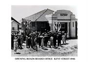
Constructed from 1946
• The place has aesthetic value as a landmark in the town and as a modest example of the Inter War stripped classical style. • The place has historic value for its association with the development of the town in the period following World War Two. • The place has social value for the members of the community who attended the place as local government offices from 1946 to 1971; and as a museum from 1971.
Post-WWII single storey brick and tiled building with art deco influences in its design. The building has two main entrances addressing Kent Street and Flinders Lane, with the principal façade facing Flinders Lane. Both entrances incorporate rendered parapet walls and ornamentation. The Flinders Lane parapet has ‘MUSEUM’ painted across the rendered expanse whilst the Kent Street parapet incorporates a narrow rectangular opening filled with polychromatic brickwork. A flat roof timber and fibre cement porch has been added to the Flinders Lane entrance. The brickwork is laid in stretcher bond with canted brick window sills. Windows are timber framed sashes, divided horizontally into 2, 3 and 5 panes reflective of the architectural style of the building. The roof is hipped with Marseille tile and wide eaves lined with fibre cement sheeting. A foundation stone dated 3 July 1946 is located to the north west of the Flinders Lane entry. A timber framed and fibre cement addition is located to the rear of the property and forms part of the museum function, with a further addition to the south east of the main entrance, clad in wire mesh obscuring much of the south east elevation of the building. Mosaic artwork reflecting the Timber Railway Line 1872-1908 has been installed adjacent to the building.
The Rockingham Roads Board was established in 1897 with inaugural members John Thorpe, William Day, George Mead, James Junior and John Bell, Daniel Hymus and Charles Parkin, J.P. who was the Chairman. The office was a small one roomed timber building, with a stone frontage located on the corner of Office Road and Mandurah Road. In 1933, the Roads Board office was leased by the Education Department to supplement accommodation for the East Rockingham School, which was located on the other side of Mandurah Road on the corner of Wellard Road. This decision was influenced by the view that the Roads Board office was too far from the town and the office moved to rented accommodation in Rockingham. In 1946, a new Rockingham Roads Board Office costing £1850 was built on this site. The building, designed by architect E.W. Warne was opened by the Lieutenant Governor Sir James Mitchell on 25 October 1946. At the opening, the Chairman of the Rockingham Road Board, Mr G.E. Grigg, noted that during his association with the Road Board over 24 years, the board offices had been located in 'cottages, shops and other buildings and the new office would be greatly appreciated'. In 1971, new offices were built to accommodate the growing Shire of Rockingham and this building was vacated. In 1979, the former offices were offered to the Rockingham District Historical Society who had previously occupied premises on Marine Terrace since their establishment in 1969. In 1988, the building was extended to join with the library which occupied the rear site and in 1999 the library services vacated that building. The museum extended its occupancy to include the former library space and the volunteer staff has continued to collect items relevant to the City of Rockingham and put on regular displays.
Integrity: Moderate Degree Authenticity: High Degree
Good
| Name | Type | Year From | Year To |
|---|---|---|---|
| E.W. Warne | Architect | 1946 | - |
| Ref ID No | Ref Name | Ref Source | Ref Date |
|---|---|---|---|
| Articles - 27 Mar 1946, p3; 26 Oct 1946, p18. | The West Australian | Mar 1946 & Oct 1946 | |
| Place Records | City of Rocking MHI | September 2012 | |
| Landgate Land Information and aerial photographs | Landgate |
| Reserve | Lot/Location | Plan/Diagram | Vol/Folio |
|---|---|---|---|
| 503 | 52694 |
| Owner | Category |
|---|---|
| City of Rockingham | Local Gov't |
This information is provided voluntarily as a public service. The information provided is made available in good faith and is derived from sources believed to be reliable and accurate. However, the information is provided solely on the basis that readers will be responsible for making their own assessment of the matters discussed herein and are advised to verify all relevant representations, statements and information.
9 Kent St Rockingham
Lot 1 on Strata Plan 18613 and Diagram 76519
Rockingham
Metropolitan
Constructed from 1896 to 1897
| Type | Status | Date | Documents |
|---|---|---|---|
| (no listings) |
| Type | Status | Date | Documents |
|---|---|---|---|
| (no listings) |
| Type | Status | Date | Grading/Management | |
|---|---|---|---|---|
| Category | ||||
| Municipal Inventory | Adopted | 25 Mar 2008 | Category E | |
Historic Site
| Epoch | General | Specific |
|---|---|---|
| Original Use | EDUCATIONAL | Primary School |
This information is provided voluntarily as a public service. The information provided is made available in good faith and is derived from sources believed to be reliable and accurate. However, the information is provided solely on the basis that readers will be responsible for making their own assessment of the matters discussed herein and are advised to verify all relevant representations, statements and information.
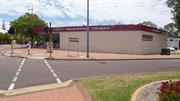
Constructed from 1897
• The site has historic value for its association with the provision of education to the Rockingham community from 1897 to 1934. • The site has social value for the members of the community who attended the school at that location or remember the school building at that location until the 1960s.
The site was redeveloped in the 1970s and no evidence of the school remains extant.
The town of Rockingham slowly expanded in the 1890s, largely as a result of the booming timber industry and the subsequent exports of timber from the Rockingham jetty. In 1896, the first police station was built, in Kent Street, and the Rockingham Beach School was established on the south east corner Kent Street and Patterson Road. In 1897, the Rockingham Roads Board District was established, with the first meetings of the Board held on 21 May 1897. By 1908, with the port operations at an end, the town of Rockingham experienced serious decline. Police officers were no longer permanently based at the station; the school was closed down; the bakery closed. With difficulty, James Bell continued to operate his butcher shop and store, and the Hymus family, the Port Hotel. With the outbreak of war in 1914, the limited population of the Rockingham district was depleted further as able-bodied men enlisted for military service. With the closure of the Rockingham School in 1907, children from the area travelled to the East Rockingham school in Office Road. During the Inter War period an increase of the population in the district lead to the reopening of the school in Kent Street. In 1933, the Rockingham Road Board gave permission to the Education Department to use the Rockingham Hall for school purposes because of the increased number of students. The school continued to operate until the new school was opened in Bay View Street in 1935. The original school building in Kent Street was incorporated into a caravan park which was located on the site. Aerial photographs indicate that the school building was removed in the early 1960s.
This information is provided voluntarily as a public service. The information provided is made available in good faith and is derived from sources believed to be reliable and accurate. However, the information is provided solely on the basis that readers will be responsible for making their own assessment of the matters discussed herein and are advised to verify all relevant representations, statements and information.