Local Government
Rockingham
Region
Metropolitan
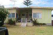
505 Safety Bay Rd Safety Bay
Rockingham
Metropolitan
Constructed from 1950
| Type | Status | Date | Documents |
|---|---|---|---|
| (no listings) |
| Type | Status | Date | Documents |
|---|---|---|---|
| (no listings) |
| Type | Status | Date | Grading/Management | |
|---|---|---|---|---|
| Category | ||||
| Municipal Inventory | Adopted | 27 Apr 2011 | Category C | |
Individual Building or Group
| Epoch | General | Specific |
|---|---|---|
| Original Use | RESIDENTIAL | Single storey residence |
| Present Use | RESIDENTIAL | Single storey residence |
This information is provided voluntarily as a public service. The information provided is made available in good faith and is derived from sources believed to be reliable and accurate. However, the information is provided solely on the basis that readers will be responsible for making their own assessment of the matters discussed herein and are advised to verify all relevant representations, statements and information.
Constructed from 1950
Aesthetic Value: the place is a rare example of a weatherboard holiday house built in c1950 along Safety Bay Road. Historic Value: the place is associated with the development of Rockingham as a holiday destination.
The house is a single story residence built on a sloping block at the intersection of Safety Bay Road and View Road. It is built higher than street level with walls clad with painted weatherboard on the exterior and a skillion roof. There are timber framed openings below the roof eaves along the south-western wall in the front section of the house. Timber framed windows are located regularly along the facades. There are projecting bays on the southern side of the house where the rear entry and the store are located. The rear entry is accessed via a set of timber stairs across the entry porch. A separate metal carport is located at the rear of hte house and is accessed from View Road.
Following WWII Rockingham continued to develop as a popular tourist destination with the suburbs of Rockingham, Palm Beach and Safety Bay being well patronised by holiday makers. From the 1950's, the Rockingham's development as a holiday destination continued as industrial sites began to build up. It's popular beaches and surroundings not only attracted more visitors, but also new workers settled in the area with their families. New residences and holiday houses were built on old settled lands while old houses were extended and given face lifts. Generally, houses were constructed from weatherboard and fibre cement panels with either gabled or skillion roofs. There are also apartment blocks constructed with painted masonry walls and skillion roofs built close to the seafront from this period.
Integrity: High Authenticity: High
Good
This information is provided voluntarily as a public service. The information provided is made available in good faith and is derived from sources believed to be reliable and accurate. However, the information is provided solely on the basis that readers will be responsible for making their own assessment of the matters discussed herein and are advised to verify all relevant representations, statements and information.
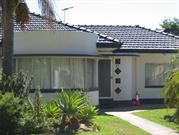
14 Scott Rd Safety Bay
Rockingham
Metropolitan
Constructed from 1968
| Type | Status | Date | Documents |
|---|---|---|---|
| Heritage List | Adopted | 24 Apr 2018 |
| Type | Status | Date | Documents |
|---|---|---|---|
| (no listings) |
| Type | Status | Date | Grading/Management | |
|---|---|---|---|---|
| Category | ||||
| Anglican Church Inventory | YES | 31 Jul 1996 | ||
| Municipal Inventory | Adopted | Category C | ||
Individual Building or Group
| Epoch | General | Specific |
|---|---|---|
| Present Use | RELIGIOUS | Church, Cathedral or Chapel |
| Original Use | RELIGIOUS | Church, Cathedral or Chapel |
| Type | General | Specific |
|---|---|---|
| Wall | BRICK | Common Brick |
| Roof | METAL | Zincalume |
| General | Specific |
|---|---|
| SOCIAL & CIVIC ACTIVITIES | Religion |
This information is provided voluntarily as a public service. The information provided is made available in good faith and is derived from sources believed to be reliable and accurate. However, the information is provided solely on the basis that readers will be responsible for making their own assessment of the matters discussed herein and are advised to verify all relevant representations, statements and information.
• the place has historic value for its association with the development of Safety Bay in the post war period and its shift to more permanent residents not just a seasonal population. • the place has social value to the many members of the community who have attended events and services at the church since the 1960s. • the place has aesthetic value as a simple demonstration of late 20th century style.
Constructed in c1960. Walls: Brick Painted and asbestos sheets Roof: metal Colorbond Architectural style: Late 20th Century
St George's Anglican Church was built to serve the growing community in Safety Bay in 1960. The architect and builder of the church have not been determined. The church foundation stone was laid by the Archbishop of Perth, Dr Moline on the 4th December 1960. In 1954, the Anglican Church designated considerable funds to the development of the Perth diocese infrastructure. The Diocesan Trustees designated approximately £240,000 to various parishes for churches, schools, halls and other facilities. This church represents the investment by the Anglican Church in part of this scheme although further research is required to confirm this conclusion. The original church building was approximately half of the current size and sometime between 1985 and 1995 the church nave was extended to double the size of the whole building.
Good
| Reserve | Lot/Location | Plan/Diagram | Vol/Folio |
|---|---|---|---|
| 9 | 98832 |
This information is provided voluntarily as a public service. The information provided is made available in good faith and is derived from sources believed to be reliable and accurate. However, the information is provided solely on the basis that readers will be responsible for making their own assessment of the matters discussed herein and are advised to verify all relevant representations, statements and information.
21 Waimea Rd Safety Bay
Lot 257 on Plan 6542
Rockingham
Metropolitan
Constructed from 1940
| Type | Status | Date | Documents |
|---|---|---|---|
| Heritage List | Adopted | 24 Apr 2018 |
| Type | Status | Date | Documents |
|---|---|---|---|
| (no listings) |
| Type | Status | Date | Grading/Management | |
|---|---|---|---|---|
| Category | ||||
| Municipal Inventory | Adopted | 02 Sep 2012 | Category C | |
Individual Building or Group
| Epoch | General | Specific |
|---|---|---|
| Present Use | RESIDENTIAL | Single storey residence |
| Original Use | RESIDENTIAL | Single storey residence |
This information is provided voluntarily as a public service. The information provided is made available in good faith and is derived from sources believed to be reliable and accurate. However, the information is provided solely on the basis that readers will be responsible for making their own assessment of the matters discussed herein and are advised to verify all relevant representations, statements and information.
Constructed from 1940
• The place has aesthetic value as a simple demonstration of the post war style expressed in brick. • The place has historic value for its association with the development of Safety Bay in the 1960s.
Single storey rendered and painted brick and tiled residence of asymmetric plan form. Distinctive curved bay window to the projecting section of the residence with aluminium framed openings, flat concrete awning and rendered parapet above projecting into the roof line. The main entrance is set behind the bay with a curved feature wall and part flat roof. The tiled roof is hipped with boxed eaves. A curved multi-pane window makes a feature of the southern corner of the façade. A large multi-paned window dominates the northern section of the façade with aluminium sliding openings and a painted rendered sill. The deep eaves provide shelter to this opening. The house is positioned approximately mid-way within the lot with open gardens to the front without a street boundary and driveway along the northern side of the house.
Following World War Two Rockingham continued to develop as a popular tourist destination with the suburbs of Rockingham, Palm Beach and Safety Bay being well patronized by holidaymakers. The popular beaches not only attracted more visitors but also workers, settled in the area with their families as industrial sites began to be established in the region. This portion of Safety Bay was not developed until the late 1950s with the area characterised by sandy scrub and minimal access roads. A subdivision plan for this site and the surrounding lots was approved by the Department of Lands in 1955. The origin of the name Waimea Road has not been confirmed however several origins have been proposed. The wife of land agent, Alfred Watts was named Helen Waimea Saunders (c1879-1968) and as he was responsible for many subdivisions in Safety Bay it is possible he named the name in her honour. Alternatively the name of this Hawaiian town could have been chosen to reflect a holiday mood. In addition, a barque name Waimea visited Rockingham in 1898/99 which may have left a lasting impression with the local residents. This residence was constructed c1960 as it was not present in 1953 but constructed by 1965. It has not been established who was the original owner or occupant of this residence. Aerial photographs indicate that the original residence has not been significantly altered since its construction although other structures have been built on the lot.
Integrity: High Authenticity: High
Good
This information is provided voluntarily as a public service. The information provided is made available in good faith and is derived from sources believed to be reliable and accurate. However, the information is provided solely on the basis that readers will be responsible for making their own assessment of the matters discussed herein and are advised to verify all relevant representations, statements and information.
Oneida Rd Secret Harbour
cnr Warnbro Sound Avenue
Rockingham
Metropolitan
Constructed from 2009
| Type | Status | Date | Documents |
|---|---|---|---|
| (no listings) |
| Type | Status | Date | Documents |
|---|---|---|---|
| RHP - Does not warrant assessment | Current | 28 Sep 2012 |
| Type | Status | Date | Grading/Management | |
|---|---|---|---|---|
| Category | ||||
| (no listings) | ||||
Individual Building or Group
| Epoch | General | Specific |
|---|---|---|
| Present Use | GOVERNMENTAL | Police Station or Quarters |
This information is provided voluntarily as a public service. The information provided is made available in good faith and is derived from sources believed to be reliable and accurate. However, the information is provided solely on the basis that readers will be responsible for making their own assessment of the matters discussed herein and are advised to verify all relevant representations, statements and information.
118 Arcadia Dr Shoalwater
Lot 2 on Diagram 11034
Rockingham
Metropolitan
Constructed from 1950
| Type | Status | Date | Documents |
|---|---|---|---|
| Heritage List | Adopted | 24 Apr 2018 |
| Type | Status | Date | Documents |
|---|---|---|---|
| (no listings) |
| Type | Status | Date | Grading/Management | |
|---|---|---|---|---|
| Category | ||||
| Municipal Inventory | Adopted | 24 Apr 2018 | Category C | |
Individual Building or Group
| Epoch | General | Specific |
|---|---|---|
| Present Use | RESIDENTIAL | Single storey residence |
| Original Use | RESIDENTIAL | Single storey residence |
This information is provided voluntarily as a public service. The information provided is made available in good faith and is derived from sources believed to be reliable and accurate. However, the information is provided solely on the basis that readers will be responsible for making their own assessment of the matters discussed herein and are advised to verify all relevant representations, statements and information.
Constructed from 1950
• The place has aesthetic value as a simple demonstration of the post war style expressed in asbestos sheeting. • The place has historic value for its association with the development of Shoalwater in the 1960s as a holiday destination.
Single storey house set back from the street in a large open lawned garden with no designated driveway. The main western elevation of the house is screened by mature shrubs, obscuring the beach views from the house. The walls are clad in blue painted fibre-cement and penetrated at regular intervals by timber framed windows that are shaded by individual awnings at the sides. The main entrance is on the western corner of the north wall with and is screened by a timber lattice to the northwest corner. A continuous metal awning with thick blue and white vertical stripes cover the length of the front elevation and wraps around both sides to one third of the length of the house. The gabled roof is clad in corrugated metal sheets with the rear one third of the building splaying slightly at both sides.
Following World War Two Rockingham continued to develop as a popular tourist destination with the suburbs of Rockingham, Palm Beach and Safety Bay being well patronized by holidaymakers. The popular beaches not only attracted more visitors but also workers, settled in the area with their families as industrial sites began to be established in the region. This area of Shoalwater was subdivided for residential settlement in 1938. The first developments were largely holiday homes with some permanent residents. This residence appears to have been built c1960 although it is possible that a structure was on the site prior to this construction. It has not been established who was the original owner or occupant of this residence. Aerial photographs indicate that the residence has not been significantly altered since the mid 20th century although other structures have been built at the rear of the lot.
Integrity: High Authenticity: High
Fair
This information is provided voluntarily as a public service. The information provided is made available in good faith and is derived from sources believed to be reliable and accurate. However, the information is provided solely on the basis that readers will be responsible for making their own assessment of the matters discussed herein and are advised to verify all relevant representations, statements and information.
124 Arcadia Dr Shoalwater
Lot 11 on Diagram 12971
Rockingham
Metropolitan
Constructed from 1940
| Type | Status | Date | Documents |
|---|---|---|---|
| Heritage List | Adopted | 24 Apr 2018 |
| Type | Status | Date | Documents |
|---|---|---|---|
| (no listings) |
| Type | Status | Date | Grading/Management | |
|---|---|---|---|---|
| Category | ||||
| Municipal Inventory | Adopted | 24 Apr 2018 | Category C | |
Individual Building or Group
| Epoch | General | Specific |
|---|---|---|
| Present Use | RESIDENTIAL | Single storey residence |
| Original Use | RESIDENTIAL | Single storey residence |
This information is provided voluntarily as a public service. The information provided is made available in good faith and is derived from sources believed to be reliable and accurate. However, the information is provided solely on the basis that readers will be responsible for making their own assessment of the matters discussed herein and are advised to verify all relevant representations, statements and information.
Constructed from 1940
• The place has aesthetic value as a simple demonstration of the Inter War Functionalist style. • The place has historic value for its association with the development of Shoalwater in the 1950s as a holiday destination.
Single storey dwelling set back from the street behind a painted brick and metal fence, dense mature plantings and lawn, there is no designated driveway. A set of metal gates are located by the southern boundary with a paved path leading to the house. The house is a combination of brick and fibre-cement panels with timber framed windows. The hipped roof, extending over the verandah in the south northwest corner, is clad in terracotta tiles. The verandah roof is supported on simple square timber posts with decorative brackets. The verandah space extends beyond the roof line with a low arched masonry wall enclosing the area and providing access via 4 brick steps near the centre of the front elevation. The front entrance aligns with the verandah steps and is set on the rear wall of the verandah. A projecting painted brickwork bay sits adjacent to the verandah with the wall extending beyond the roof line to create a parapet.
Following World War Two Rockingham continued to develop as a popular tourist destination with the suburbs of Rockingham, Palm Beach and Safety Bay being well patronized by holidaymakers. The popular beaches not only attracted more visitors but also permanent residents settled in the area with their families as industrial sites began to be established in the region. A subdivision plan for this portion of Shoalwater was approved in 1928 although it was not significantly developed until the post war period. This residence appears to have been built c1950 as it is present in a 1953 aerial photograph. It has not been established who was the original owner or occupant of this residence. Aerial photographs indicate the residence has not been significantly altered since the mid-20th century.
Integrity: High Authenticity: High
Good
This information is provided voluntarily as a public service. The information provided is made available in good faith and is derived from sources believed to be reliable and accurate. However, the information is provided solely on the basis that readers will be responsible for making their own assessment of the matters discussed herein and are advised to verify all relevant representations, statements and information.
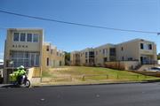
166 - 168 Arcadia Dr Shoalwater
Rockingham
Metropolitan
Constructed from 1950
| Type | Status | Date | Documents |
|---|---|---|---|
| Heritage List | Adopted | 24 Apr 2018 |
| Type | Status | Date | Documents |
|---|---|---|---|
| (no listings) |
| Type | Status | Date | Grading/Management | |
|---|---|---|---|---|
| Category | ||||
| Municipal Inventory | Adopted | 24 Apr 2018 | Category D | |
Individual Building or Group
| Epoch | General | Specific |
|---|---|---|
| Present Use | COMMERCIAL | Other |
| Original Use | COMMERCIAL | Other |
This information is provided voluntarily as a public service. The information provided is made available in good faith and is derived from sources believed to be reliable and accurate. However, the information is provided solely on the basis that readers will be responsible for making their own assessment of the matters discussed herein and are advised to verify all relevant representations, statements and information.
Constructed from 1950
• The place has aesthetic value as a rare example of two storey apartments with an unusual staggered layout. • The place has historic value for its association with the development of Safety Bay as a holiday destination in the 1950s.
A pair of rendered and face brick apartment buildings constructed in a similar manner, with a stepped construction so each apartment has a view to the ocean. The stepped construction forms a ‘V’ with the two apartments at the rear of the site being located close to each other whilst the front two apartments are the furthest apart separated by a grassed area with a gentle incline from the street edge. The apartment blocks are essentially three storeys but to the street front, they mainly present as two storey development. The roofs to both blocks are opposing skillions with corrugated iron. Parking is to the rear of both blocks comprising of below street level open parking.
Following World War Two Rockingham continued to develop as a popular tourist destination with the suburbs of Rockingham, Palm Beach and Safety Bay being well patronized by holidaymakers. From the 1950s, the Rockingham area continued to develop as a popular holiday destination and industrial sites had started to build up. Its popular beaches and surroundings not only attracted more visitors but also permanent residents, settled in the area with their families. These two apartment blocks built sometime between 1953 and 1965 demonstrate the style of the period. Aerial photographs demonstrate that there was an explosion of building during this period and it is also apparent that the buildings have not changed significantly in form or extent since 1965.
Integrity: High Authenticity: High
Fair
This information is provided voluntarily as a public service. The information provided is made available in good faith and is derived from sources believed to be reliable and accurate. However, the information is provided solely on the basis that readers will be responsible for making their own assessment of the matters discussed herein and are advised to verify all relevant representations, statements and information.
Penguin Island Shoalwater
Part of Shoalwater Islands Chain
Rockingham
Metropolitan
| Type | Status | Date | Documents |
|---|---|---|---|
| Heritage List | Adopted | 24 Apr 2018 |
| Type | Status | Date | Documents |
|---|---|---|---|
| RHP - To be assessed | Current | 26 Aug 2011 |
| Type | Status | Date | Grading/Management | |
|---|---|---|---|---|
| Category | ||||
| Register of the National Estate | Registered | 21 Mar 1978 | ||
| Municipal Inventory | Adopted | 02 Sep 2012 | Category A | |
· The place has been a tourism destination since the late 1880s to the present day.
· The island is home to 1200 penguins, and is the most northerly place that the ‘little penguin’ species can be found.
· The island’s penguin colony is the largest known penguin breeding colony in Western Australia.
· The place currently functions as an educational centre.
· The place is associated with Seaforth MacKenzie.
· The place previously accommodated a holiday complex built into the natural limestone caves.
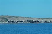
Penguin Island and Mercy Point are located approximately 50 kilometres to the south of Perth in the suburb of Rockingham. The Island is less than 700 metres east of Mersey Point, and can be accessed via ferry. The island is closed to visitors at night.
The district of Rockingham was first settled by Thomas Peel and four hundred indentured workers who arrived on the Gilmore, the Industry and the Rockingham between December 1829 and May 1830. The Rockingham townsite was officially gazetted in July 1846. As early as the 1870s, Penguin Island was used by whalers, sealers and local fishermen, and by 1889 the island had been exploited for its tourism potential, and steam boat tours had been organised leaving from Fremantle’s South Jetty. The island remained uninhabited until c. 1914 when Seaforth MacKenzie and all his belongings were removed from Garden Island and moved to Penguin Island by the Australian Navy who were using Garden Island for military purposes. The Navy helped MacKenzie to set up an establishment in a small cave located in the northern part of the island, facing the mainland. With assistance from passing yachtsmen MacKenzie used the existing limestone caves, and with tools and explosives, the original cave was widened and deepened and other caves were created from the rock.
Large Conservation Region
| Epoch | General | Specific |
|---|---|---|
| Present Use | SOCIAL\RECREATIONAL | Other |
| Original Use | PARK\RESERVE | Park\Reserve |
| Other Use | RESIDENTIAL | Other |
| Present Use | EDUCATIONAL | Other |
| General | Specific |
|---|---|
| SOCIAL & CIVIC ACTIVITIES | Environmental awareness |
| OUTSIDE INFLUENCES | Tourism |
| SOCIAL & CIVIC ACTIVITIES | Education & science |
| SOCIAL & CIVIC ACTIVITIES | Sport, recreation & entertainment |
This information is provided voluntarily as a public service. The information provided is made available in good faith and is derived from sources believed to be reliable and accurate. However, the information is provided solely on the basis that readers will be responsible for making their own assessment of the matters discussed herein and are advised to verify all relevant representations, statements and information.
Aesthetic Value: The remains of former dwellings located within natural and man-made coastal caves on Penguin Island reveals the aesthetic characteristics of the earlier structures and their setting. Historic Value: Penguin Island and Mersey Point are associated with a number of former occupants, most particularly, Seaforth MacKenzie, who lived on the island from 1914 and tried to develop the island into a holiday resort. Social Value: Penguin Island and Mersey point are valued by the community for it's association with Seaforth MacKenzie, and also as a popular tourist attraction. Scientific Value: Penguin Island has the ability to reveal archaeological information about the use and development through the 1920's.
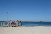
Penguin Island is situated within the Shoalwater Islands marine park, a unique marine environment that surrounds a chain of limestone islands. Penguin Island is located approximately 700 metres off shore from Mersey Point and has an area 12.5 hectares. The island is characterised by limestone overhangs, cliffs, caves and is covered by low lying shrubs. The island has extensive visitor facilities including picnic areas, boardwalks, walkways and lookout platforms. An Interpretive Centre is located on the island, which is accessible from the jetty to the east. Mersey point is located at the south-eastern tip of Safety Bay and is the primary departure point for access to Penguin Island. Facilities at Mersey Point include a kiosk, visitor's centre and gift shop. The jetty is accessed via a timber gazebo
Penguin Island was probably first used by the Aboriginal people who have believed to have been in the area up to 12,000 years ago. Paul Seaforth McKenzie, a well known local resident, squatted intermittently on Penguin Island from around 1914. After the Island was gazetted a reserve for public use in 1918, an annual lease was granted to McKenzie. He developed a holiday resort on the island, with himself as caretaker and host. He decided to utilize the limestone caves on the Island; using tools and explosives to extend some, and excavating a number of new ones. Some were equipped for campers, with a fireplace, shelves and rock ledges where bedding could be placed. Hessian sheets were hung from the ceiling to catch falling sand. The caves had grand names such as 'Fairhaven' and 'Tudor Hall', while McKenzie lived in the timber and iron 'Manor hall'. The well (1m x1m x 2m in depth) was neatly and precisely cut out of the limestone on Penguin Island. The well was used as a source of fresh water for campers during Seaforth McKenzie's time on the island, and by squatters during the Depression Years. After McKenzie left the island in the 1930's it continued to be a place of recreation, operated by various lessees until the 1980's when the Department of Conservation and Land Management bought out the lease to protect the environmental values of the land. The history of Mersey Point is closely linked to Penguin Island as it is the departure point to the island. In the 1930s, a small shop, Maddern’s Store, was located at Mersey Point for holidaymakers and locals.
Integrity: High Authenticity: High
Good
| Owner | Category |
|---|---|
| City of Rockingham | Local Gov't |
| Department of Planning and Infrastructure | State Gov't |
This information is provided voluntarily as a public service. The information provided is made available in good faith and is derived from sources believed to be reliable and accurate. However, the information is provided solely on the basis that readers will be responsible for making their own assessment of the matters discussed herein and are advised to verify all relevant representations, statements and information.
54 Penguin Rd Shoalwater
Lot 78 on Strata 69084
Rockingham
Metropolitan
Constructed from 1931
| Type | Status | Date | Documents |
|---|---|---|---|
| (no listings) |
| Type | Status | Date | Documents |
|---|---|---|---|
| (no listings) |
| Type | Status | Date | Grading/Management | |
|---|---|---|---|---|
| Category | ||||
| Municipal Inventory | Adopted | 24 Apr 2018 | Category E | |
Individual Building or Group
| Epoch | General | Specific |
|---|---|---|
| Present Use | RESIDENTIAL | Single storey residence |
| Original Use | RESIDENTIAL | Single storey residence |
| Type | General | Specific |
|---|---|---|
| Wall | STONE | Local Stone |
This information is provided voluntarily as a public service. The information provided is made available in good faith and is derived from sources believed to be reliable and accurate. However, the information is provided solely on the basis that readers will be responsible for making their own assessment of the matters discussed herein and are advised to verify all relevant representations, statements and information.
Constructed from 1931
The site has historic value for its association with the Monkhouse family who made a significant contribution to the Safety Bay community.
Demolished with no evidence of former residence remaining extant.
In the late 1920s, lots in the Penguin Estate at Safety Bay were offered for sale by developers and from the early 1930s, simple holiday homes were built on some of these blocks. A simple home was built on this lot by Clarence Roy Monkhouse (c1898-1956) and his wife Hazel, nee Grant (c1901-1969). Following Clarence's death in 1956, Hazel lived on in the house until the late 1960s. Their simple home was representative of the homes built during the Inter War period in Safety Bay. Clarence Monkhouse made a significant contribution to the community serving as a member of the Rockingham Roads Board in 1944-46 and was the founder and Commodore of the Safety Bay Yacht Club in the late 1940s. The Monkhouse residence was built around 1931 and was typical of the kind of homes built in the area at the time. The residence was a single storey weatherboard and fibro residence with a hipped iron roof and a timber-framed verandah on four sides. The place was demolished in 2005.
This information is provided voluntarily as a public service. The information provided is made available in good faith and is derived from sources believed to be reliable and accurate. However, the information is provided solely on the basis that readers will be responsible for making their own assessment of the matters discussed herein and are advised to verify all relevant representations, statements and information.
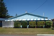
12 Watts Rd Shoalwater
Lot 174 on Plan 5737
Rockingham
Metropolitan
| Type | Status | Date | Documents |
|---|---|---|---|
| Heritage List | Adopted | 24 Apr 2018 |
| Type | Status | Date | Documents |
|---|---|---|---|
| (no listings) |
| Type | Status | Date | Grading/Management | |
|---|---|---|---|---|
| Category | ||||
| Municipal Inventory | Adopted | 24 Apr 2018 | Category B | |
Individual Building or Group
| Epoch | General | Specific |
|---|---|---|
| Present Use | SOCIAL\RECREATIONAL | CWA Hall |
| Original Use | SOCIAL\RECREATIONAL | CWA Hall |
This information is provided voluntarily as a public service. The information provided is made available in good faith and is derived from sources believed to be reliable and accurate. However, the information is provided solely on the basis that readers will be responsible for making their own assessment of the matters discussed herein and are advised to verify all relevant representations, statements and information.
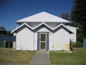
Constructed from 1952
The place has aesthetic value as a simple example of the post war style expressed in asbestos sheeting.
Single storey building with distinctive triple roofed entry. The structure is timber framed with fibre cement cladding on a brick base with hipped, gables and skillion roofs clad in Colorbond. The building is simple in form with the main hall being housed in a rectangular building which was part of the original construction. The skillion roofed side (south) addition is of similar construction method and was added in the 1950s. The distinctive triple roof entry was added in the 1990s and is also of timber framed construction. The central gable section containing the entrance door is the original porch. The windows are aluminium framed openings. The CWA Building is positioned within a large lot which is open to the street boundary.
The Country Women’s Association (CWA) is an organization of women whose aim is to improve the conditions for families, women and children, particularly those living in rural and remote Australia. The Rockingham Branch of the CWA was formed in 1936. The Safety Bay branch of the CWA had its inaugural meeting on 19 August 1946 in the Safety Bay Progress Hall. The Safety Bay CWA Hall was constructed in 1952 through the efforts of local volunteers with funds raised by the CWA members. The building was designated as a 'Rest Room' and at the opening of the new premises the President of the Safety Bay CWA, Miss Piesse thanked the 27 men who had contributed to the construction. The construction team was led by Mr W. Lee, Mr H. France and Mr R. Winzer. At the time of opening a plaque was installed within the hall that listed all the volunteers. Since its construction, a small addition was constructed on the southern elevation sometime prior to 1965. The distinctive front awning was constructed c1990 and replaced a simple awning over the main entrance. The building continues to be used as a centre for the Safety Bay branch of the CWA.
Integrity: High Authenticity: High
Good
This information is provided voluntarily as a public service. The information provided is made available in good faith and is derived from sources believed to be reliable and accurate. However, the information is provided solely on the basis that readers will be responsible for making their own assessment of the matters discussed herein and are advised to verify all relevant representations, statements and information.
E Side of Penguin Island Shoalwater Bay
Rockingham
Metropolitan
Constructed from 1920
| Type | Status | Date | Documents |
|---|---|---|---|
| Heritage List | Adopted | 24 Apr 2018 |
| Type | Status | Date | Documents |
|---|---|---|---|
| (no listings) |
| Type | Status | Date | Grading/Management | |
|---|---|---|---|---|
| Category | ||||
| Municipal Inventory | Adopted | 22 Dec 1998 | Category B | |
03164 Penguin Island and Mersey Point
Historic site
| Epoch | General | Specific |
|---|---|---|
| Present Use | RESIDENTIAL | Other |
| Original Use | RESIDENTIAL | Other |
| Type | General | Specific |
|---|---|---|
| Wall | STONE | Local Stone |
| Other | TIMBER | Other Timber |
This information is provided voluntarily as a public service. The information provided is made available in good faith and is derived from sources believed to be reliable and accurate. However, the information is provided solely on the basis that readers will be responsible for making their own assessment of the matters discussed herein and are advised to verify all relevant representations, statements and information.
Constructed from 1920
• the place has aesthetic value as a collection of simple coastal caves, both naturally occurring or excavated, that reveal a rough simplicity in the rugged landscape. • the place has historic value for its association with Paul Seaforth McKenzie who developed the island as a holiday destination from 1914 to 1926. • the place has social value for the community for its association with the well- known character, Seaforth MacKenzie, and for its ongoing function as a tourist destination. • the place has potential research value for its potential to reveal archaeological information about its former use and construction during the 1920s.
Limestone caves on the eastern side of the island previously converted to basic accommodation and now in their natural state. Access is no longer provided to the caves due to the dangerous condition of the rocky overhang. The majority of caves retain their open entrances but a number of them have fencing and walls and reinforcement. A well is located to the south of the caves which has filled with sand. Interpretative signage marks the location of the well. Shelves have been dug into the walls of the cave, and the remains of a rough hand-carved inscription can be seen in one cave.
Paul Seaforth McKenzie (1853-1939) a native of Canada arrived in Western Australia sometime c1900 and after travelling around the state squatted intermittently in Penguin Island from around 1914. After the Island was gazetted a reserve for public use in 1918, an annual lease was granted to McKenzie. He planned to develop a holiday resort on the Island, with himself as caretaker and host. McKenzie utilized the limestone caves on the Island as accommodation. Using tools and explosives to extend some, and excavating a number of new ones. Some were equipped for campers, with a fireplace, shelves, and rock ledges where bedding could be placed. Hessian sheets were hung from the ceiling to catch falling sand. The caves had grand names such as ‘Fairhaven’ and ‘Tudor Hall’, while McKenzie lived in the timber and iron ‘Manor Hall’. A small cave housed McKenzie’s store where an honour system operated. He also had a library that he made freely available to visitors. Stones led into a cave which protected the visitor’s drinking water, and food needing cool storage could also be kept there. McKenzie had a well that supplied brackish water for washing. In 1926, McKenzie’s lease at Penguin Island was terminated. He bought land at Mersey Point, Safety Bay, where he built a house and a shop. In 1932, he travelled to New Zealand where members of his family lived. He settled there until his death in 1939. The entrance to the Kitchen/Store Cave had a manmade doorway built into it. This cave was used for camping by many visitors to the Island and later was the home of Tom Polland and his family during the Depression years of the early 1930s. The well (1m x 1m x 2m in depth) was neatly and precisely cut out of the limestone on Penguin Island. The well was used as a source of fresh water for campers during Seaforth McKenzie’s time on the Island and by squatters during the Depression years. The island is now a protected reserve which is accessed by day trippers by a short ferry ride from the mainland.
Integrity: Moderate Degree Authenticity: Moderate Degree
Good
| Owner | Category |
|---|---|
| Department for Planning and Infrastructure | State Gov't |
| Department for Conservation and Land Management | State Gov't |
This information is provided voluntarily as a public service. The information provided is made available in good faith and is derived from sources believed to be reliable and accurate. However, the information is provided solely on the basis that readers will be responsible for making their own assessment of the matters discussed herein and are advised to verify all relevant representations, statements and information.
E Side of Penguin Island Shoalwater Bay
Rockingham
Metropolitan
Constructed from 1920
| Type | Status | Date | Documents |
|---|---|---|---|
| (no listings) |
| Type | Status | Date | Documents |
|---|---|---|---|
| (no listings) |
| Type | Status | Date | Grading/Management | |
|---|---|---|---|---|
| Category | ||||
| (no listings) | ||||
03164 Penguin Island and Mersey Point
Historic site
| Epoch | General | Specific |
|---|---|---|
| Original Use | Transport\Communications | Water: Other |
| Present Use | Transport\Communications | Water: Other |
| Type | General | Specific |
|---|---|---|
| Wall | STONE | Limestone |
This information is provided voluntarily as a public service. The information provided is made available in good faith and is derived from sources believed to be reliable and accurate. However, the information is provided solely on the basis that readers will be responsible for making their own assessment of the matters discussed herein and are advised to verify all relevant representations, statements and information.
623 Safety Bay Rd Waikiki
Lot 261 on Plan 6379
Rockingham
Metropolitan
Constructed from 1960
| Type | Status | Date | Documents |
|---|---|---|---|
| Heritage List | Adopted | 24 Apr 2018 |
| Type | Status | Date | Documents |
|---|---|---|---|
| (no listings) |
| Type | Status | Date | Grading/Management | |
|---|---|---|---|---|
| Category | ||||
| Municipal Inventory | Adopted | 24 Apr 2018 | Category D | |
Individual Building or Group
| Epoch | General | Specific |
|---|---|---|
| Present Use | RESIDENTIAL | Single storey residence |
| Original Use | RESIDENTIAL | Single storey residence |
This information is provided voluntarily as a public service. The information provided is made available in good faith and is derived from sources believed to be reliable and accurate. However, the information is provided solely on the basis that readers will be responsible for making their own assessment of the matters discussed herein and are advised to verify all relevant representations, statements and information.
Constructed from 1960
• The place has aesthetic value as a simple demonstration of the post war style expressed in brick and asbestos sheeting. • The place has historic value for its association with the development of Safety Bay in the 1960s.
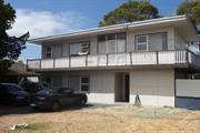
Two storey residence with an open garden comprising of lawn, mature shrubs and trees towards the side boundaries and a low picket fence to one side. The fibre-cement walls of the house are penetrated by a series of windows along its main northeast façade and an off-centre entrance. The windows are grouped in threes, a larger fixed pane alongside two smaller awning windows, one above the other. The upper storey features a wraparound balcony with a continuous timber balustrade. The balcony can be accessed by a glass door with side and fanlights, roughly above the ground floor entrance below. The roof cannot be seen from street level. A bitumen crossover is located approximately central on the lot with a concrete driveway expanding towards the house and concrete pavers continuing to the carport between the northwest boundary and side of the house.
Following World War Two Rockingham continued to develop as a popular tourist destination with the suburbs of Rockingham, Palm Beach and Safety Bay being well patronized by holidaymakers. The popular beaches not only attracted more visitors but also permanent residents, settled in the area with their families as industrial sites began to be established in the region. The suburb of Waikiki was undeveloped in the 1950s. A subdivision plan for this site and the surrounding lots was approved by the Department of Lands in 1954. This residence was built in the late 1960s as it is not apparent in an aerial photograph of the site in 1965 although the lot does appear to be cleared. It has not been established who was the original owner or occupant of this residence. Aerial photographs indicate that the residence has not changed significantly in form or extent since its construction.
Integrity: High Authenticity: High
Fair
This information is provided voluntarily as a public service. The information provided is made available in good faith and is derived from sources believed to be reliable and accurate. However, the information is provided solely on the basis that readers will be responsible for making their own assessment of the matters discussed herein and are advised to verify all relevant representations, statements and information.
28 Brixham Way Warnbro
Rockingham
Metropolitan
Constructed from 1992
| Type | Status | Date | Documents |
|---|---|---|---|
| (no listings) |
| Type | Status | Date | Documents |
|---|---|---|---|
| (no listings) |
| Type | Status | Date | Grading/Management | |
|---|---|---|---|---|
| Category | ||||
| Anglican Church Inventory | YES | 31 Jul 1996 | ||
Individual Building or Group
| Epoch | General | Specific |
|---|---|---|
| Original Use | RELIGIOUS | Housing or Quarters |
| Present Use | RELIGIOUS | Housing or Quarters |
| Type | General | Specific |
|---|---|---|
| Wall | BRICK | Common Brick |
| Roof | TILE | Cement Tile |
| General | Specific |
|---|---|
| SOCIAL & CIVIC ACTIVITIES | Religion |
This information is provided voluntarily as a public service. The information provided is made available in good faith and is derived from sources believed to be reliable and accurate. However, the information is provided solely on the basis that readers will be responsible for making their own assessment of the matters discussed herein and are advised to verify all relevant representations, statements and information.
5 Martell St Warnbro
Lot 550 on Plan 7444
Rockingham
Metropolitan
Constructed from 1950
| Type | Status | Date | Documents |
|---|---|---|---|
| Heritage List | Adopted | 24 Apr 2018 |
| Type | Status | Date | Documents |
|---|---|---|---|
| (no listings) |
| Type | Status | Date | Grading/Management | |
|---|---|---|---|---|
| Category | ||||
| Municipal Inventory | Adopted | 24 Apr 2018 | Category D | |
Individual Building or Group
| Epoch | General | Specific |
|---|---|---|
| Original Use | RESIDENTIAL | Single storey residence |
| Present Use | RESIDENTIAL | Single storey residence |
This information is provided voluntarily as a public service. The information provided is made available in good faith and is derived from sources believed to be reliable and accurate. However, the information is provided solely on the basis that readers will be responsible for making their own assessment of the matters discussed herein and are advised to verify all relevant representations, statements and information.
Constructed from 1950
• The place has aesthetic value as a simple demonstration of the post war style expressed in asbestos sheeting. • The place has historic value for its association with the development of Warnbro in the 1960s as a holiday destination.
Single storey timber framed dwelling, set amongst an open garden comprising mature shrubs, lawn and low stone garden beds. The house faces north with its main symmetrical façade featuring a deep recessed verandah, centrally located and raised four steps from ground level with a metal balustrade and gate. The main entrance is in the centre of the verandah with an obscure glazed window either side. The wall cladding is a combination of painted flat and corrugated fibre-cement with a series of corner windows on either side of the verandah, there are no visible openings to the east or west. The corrugated iron roof is flat above the verandah, flanked by shallow pitched roofs to either side. A concrete driveway runs along the west side of the boundary, leading to a detached single width metal garage with glimpses of a new double width garage behind.
Following World War Two Rockingham continued to develop as a popular tourist destination with the suburbs of Rockingham, Palm Beach and Safety Bay being well patronized by holidaymakers. The popular beaches not only attracted more visitors but also workers, settled in the area with their families as industrial sites began to be established in the region. The suburb of Warnbro was undeveloped in the 1950s with the area characterised by sandy scrub and minimal access roads. A subdivision plan for this site and the surrounding lots was approved in 1960. This residence was constructed in the early 1960s and was one of the first in the street and adjacent area. According to the Rate Books, in 1961, the property was owned by Robert Burns and had not been developed at that time which suggests it was built shortly thereafter as it is evident in 1965. Aerial photographs indicate that the original residence has not been significantly altered since its construction.
Integrity: High Authenticity: High
Fair
This information is provided voluntarily as a public service. The information provided is made available in good faith and is derived from sources believed to be reliable and accurate. However, the information is provided solely on the basis that readers will be responsible for making their own assessment of the matters discussed herein and are advised to verify all relevant representations, statements and information.