Local Government
Sandstone
Region
Midwest
off Irvine St to S of Hack St Sandstone
Sandstone
Midwest
Constructed from 1910
| Type | Status | Date | Documents |
|---|---|---|---|
| (no listings) |
| Type | Status | Date | Documents |
|---|---|---|---|
| RHP - Assessed - Below Threshold | Current | 10 Dec 2004 |
| Type | Status | Date | Grading/Management | |
|---|---|---|---|---|
| Category | ||||
| Municipal Inventory | Adopted | 25 Jun 1997 | Category 2 | |
| Statewide Lge Timber Str Survey | Completed | 11 Dec 1998 | ||
02352 Sandstone Townsite Group
| Library Id | Title | Medium | Year Of Publication |
|---|---|---|---|
| 7576 | Shire of Sandstone Railway goods shed : structural condition report. | Heritage Study {Other} | 2005 |
| 6511 | Conservation plan for Railway Goods Shed (1910), Sandstone, Western Australia. | Heritage Study {Cons'n Plan} | 2002 |
Individual Building or Group
| Epoch | General | Specific |
|---|---|---|
| Original Use | Transport\Communications | Rail: Other |
| Present Use | OTHER | Other |
| Style |
|---|
| Vernacular |
| Type | General | Specific |
|---|---|---|
| Roof | METAL | Corrugated Iron |
| Wall | METAL | Corrugated Iron |
| General | Specific |
|---|---|
| OTHER | Other Sub-Theme |
| TRANSPORT & COMMUNICATIONS | Road transport |
| TRANSPORT & COMMUNICATIONS | Rail & light rail transport |
This information is provided voluntarily as a public service. The information provided is made available in good faith and is derived from sources believed to be reliable and accurate. However, the information is provided solely on the basis that readers will be responsible for making their own assessment of the matters discussed herein and are advised to verify all relevant representations, statements and information.
Constructed from 1910, Constructed from 1949
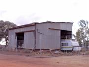
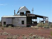
The Railway Goods Shed has high significance as one of the few remaining heritage places associated with the railway. The shed combined with the railway tank stand (Site No. 15), the railway dam and sidings are the only visual evidence of the railway which figured prominently in the development of Sandstone. The design is typical of utilitarian structures.
Large shed of timber frame construction with corrugated cladding. It has two large entrances on the east and west facades, through which the train carriages would have passed. A door rail remains as evidence of the sliding door to the east facade. An additional opening with a sliding door in place is located on the southern facade The building has a sloping roof. The shed is constructed on two levels for ease of loading. The remains of a railway siding are located adjacent to the shed.
The railway was extended to Sandstone in 1910 and remained in operation until 1949. Originally the Railway Goods Shed was much larger. The Railway Station, a timber framed corrugated iron clad structure, has been demolished along with the Station Master's House.
Integrity: Medium Degree
Fair
| Owner | Category |
|---|---|
| Crown Land | UNKNOWN |
This information is provided voluntarily as a public service. The information provided is made available in good faith and is derived from sources believed to be reliable and accurate. However, the information is provided solely on the basis that readers will be responsible for making their own assessment of the matters discussed herein and are advised to verify all relevant representations, statements and information.
Menzies-Sandstone Rd Sandstone
Menzies-Sandstone Rd- nearest rd
Sandstone
Midwest
| Type | Status | Date | Documents |
|---|---|---|---|
| (no listings) |
| Type | Status | Date | Documents |
|---|---|---|---|
| (no listings) |
| Type | Status | Date | Grading/Management | |
|---|---|---|---|---|
| Category | ||||
| Municipal Inventory | Adopted | 25 Jun 1997 | ||
09127 Dandaraga Homestead, inc Shearer's Qtrs
Individual Building or Group
| Epoch | General | Specific |
|---|---|---|
| Present Use | FARMING\PASTORAL | Homestead |
| Original Use | FARMING\PASTORAL | Homestead |
| General | Specific |
|---|---|
| OCCUPATIONS | Grazing, pastoralism & dairying |
This information is provided voluntarily as a public service. The information provided is made available in good faith and is derived from sources believed to be reliable and accurate. However, the information is provided solely on the basis that readers will be responsible for making their own assessment of the matters discussed herein and are advised to verify all relevant representations, statements and information.
The Dandaraga Homestead has historic significance for its association with the pastoral industry in the Sandstone district.
| Owner | Category |
|---|---|
| Crown | UNKNOWN |
This information is provided voluntarily as a public service. The information provided is made available in good faith and is derived from sources believed to be reliable and accurate. However, the information is provided solely on the basis that readers will be responsible for making their own assessment of the matters discussed herein and are advised to verify all relevant representations, statements and information.
Menzies-Sandstone Rd Sandstone
Menzies-Sandstone Rd- nearest rd
Sandstone
Midwest
| Type | Status | Date | Documents |
|---|---|---|---|
| (no listings) |
| Type | Status | Date | Documents |
|---|---|---|---|
| (no listings) |
| Type | Status | Date | Grading/Management | |
|---|---|---|---|---|
| Category | ||||
| (no listings) | ||||
09127 Dandaraga Homestead, inc Shearer's Qtrs
Individual Building or Group
| Epoch | General | Specific |
|---|---|---|
| Present Use | FARMING\PASTORAL | Servants or Shearers Quarters |
| Original Use | FARMING\PASTORAL | Servants or Shearers Quarters |
| General | Specific |
|---|---|
| OCCUPATIONS | Grazing, pastoralism & dairying |
This information is provided voluntarily as a public service. The information provided is made available in good faith and is derived from sources believed to be reliable and accurate. However, the information is provided solely on the basis that readers will be responsible for making their own assessment of the matters discussed herein and are advised to verify all relevant representations, statements and information.
The Dandaraga Shearer's Quarters has historic significance for its association with the Dandaraga Pastoral Station and the pastoral industry in the Sandstone district.
| Owner | Category |
|---|---|
| Crown Land | Commonwealth Gov't |
This information is provided voluntarily as a public service. The information provided is made available in good faith and is derived from sources believed to be reliable and accurate. However, the information is provided solely on the basis that readers will be responsible for making their own assessment of the matters discussed herein and are advised to verify all relevant representations, statements and information.
Off Mt Magnet Rd Sandstone
Sandstone
Midwest
| Type | Status | Date | Documents |
|---|---|---|---|
| (no listings) |
| Type | Status | Date | Documents |
|---|---|---|---|
| (no listings) |
| Type | Status | Date | Grading/Management | |
|---|---|---|---|---|
| Category | ||||
| Municipal Inventory | Adopted | 25 Jun 1997 | Category 4 | |
Individual Building or Group
| Epoch | General | Specific |
|---|---|---|
| Original Use | FARMING\PASTORAL | Stockyard |
| Present Use | VACANT\UNUSED | Vacant\Unused |
| General | Specific |
|---|---|
| OCCUPATIONS | Grazing, pastoralism & dairying |
This information is provided voluntarily as a public service. The information provided is made available in good faith and is derived from sources believed to be reliable and accurate. However, the information is provided solely on the basis that readers will be responsible for making their own assessment of the matters discussed herein and are advised to verify all relevant representations, statements and information.
The old Stock Yards have historic significance for their association with the pastoral industry in the Sandstone district.
This information is provided voluntarily as a public service. The information provided is made available in good faith and is derived from sources believed to be reliable and accurate. However, the information is provided solely on the basis that readers will be responsible for making their own assessment of the matters discussed herein and are advised to verify all relevant representations, statements and information.
Cnr Oroya & Griffiths Sts Sandstone
Sandstone
Midwest
| Type | Status | Date | Documents |
|---|---|---|---|
| (no listings) |
| Type | Status | Date | Documents |
|---|---|---|---|
| (no listings) |
| Type | Status | Date | Grading/Management | |
|---|---|---|---|---|
| Category | ||||
| (no listings) | ||||
02352 Sandstone Townsite Group
Individual Building or Group
| Epoch | General | Specific |
|---|---|---|
| Present Use | SOCIAL\RECREATIONAL | Other |
| Original Use | GOVERNMENTAL | Police Station or Quarters |
| Type | General | Specific |
|---|---|---|
| Roof | METAL | Corrugated Iron |
| Wall | METAL | Corrugated Iron |
| General | Specific |
|---|---|
| SOCIAL & CIVIC ACTIVITIES | Law & order |
This information is provided voluntarily as a public service. The information provided is made available in good faith and is derived from sources believed to be reliable and accurate. However, the information is provided solely on the basis that readers will be responsible for making their own assessment of the matters discussed herein and are advised to verify all relevant representations, statements and information.
Cnr Oroya & Thaduna Sts Sandstone
St Athanasius Roman Catholic Church
Sandstone
Midwest
Constructed from 1908
| Type | Status | Date | Documents |
|---|---|---|---|
| State Register | Registered | 20 Jul 2004 | HCWebsite.Listing+ListingDocument, HCWebsite.Listing+ListingDocument |
| Type | Status | Date | Documents |
|---|---|---|---|
| (no listings) |
| Type | Status | Date | Grading/Management | |
|---|---|---|---|---|
| Category | ||||
| Municipal Inventory | Adopted | 25 Jun 1997 | Category 2 | |
02352 Sandstone Townsite Group
| Library Id | Title | Medium | Year Of Publication |
|---|---|---|---|
| 4773 | Conservation plan for Black Range Church (formerly St Athanasius' Church) : Sandstone : Western Australia. | Heritage Study {Cons'n Plan} | 1999 |
Individual Building or Group
| Epoch | General | Specific |
|---|---|---|
| Present Use | RELIGIOUS | Church, Cathedral or Chapel |
| Original Use | RELIGIOUS | Church, Cathedral or Chapel |
| Style |
|---|
| Federation Carpenter Gothic |
| Type | General | Specific |
|---|---|---|
| Roof | METAL | Corrugated Iron |
| Wall | METAL | Corrugated Iron |
| Other | TIMBER | Other Timber |
| General | Specific |
|---|---|
| SOCIAL & CIVIC ACTIVITIES | Religion |
| SOCIAL & CIVIC ACTIVITIES | Education & science |
This information is provided voluntarily as a public service. The information provided is made available in good faith and is derived from sources believed to be reliable and accurate. However, the information is provided solely on the basis that readers will be responsible for making their own assessment of the matters discussed herein and are advised to verify all relevant representations, statements and information.
Constructed from 1908
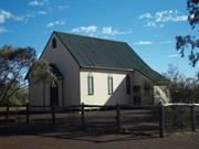
The Roman Catholic Church has high social significance as the main centre for the Catholic Church in Sandstone. The building also has high streetscape value, it being a prominent feature of the eastern section of the town. The place, in its isolated setting, has landmark value because of its striking yet simple design.
The church is timber framed, clad with corrugated iron and supported by timber stumps. Entry to the church is via several steps to a small entry porch attached to the eastern facade. The porch on the northwest corner could possibly be the priest's entrance. The roofline of this porch is covered by a lean-to roof with a slightly shallower pitch which appears to be an extension of the main roof. The church features a steeply pitched gable roof which has previously been painted green and seven slender louvre windows with pointed arch heads. A Iouvred air vent in the gable wall with a pointed top, which reflects the window shape, is situated high on the eastern facade. The guttering has come unattached or is missing in places. A wooden frame, possibly where the church bell hung, stands adjacent to the church.
The first Roman Catholic mass was held in Sandstone on 20 October, 1907. The church was built in 1908 and opened by Bishop Kelly of Geraldton on 29 November, 1908. A convent, which functioned as a convent-school for the local catholic children, was located immediately north of the church however this has been demolished. Although the Uniting Church had been using the building once a month there have been no regular services in recent times. About fifteen years ago the church bell was removed to Meekatharra.
Integrity: High Degree
| Ref ID No | Ref Name | Ref Source | Ref Date |
|---|---|---|---|
| S Senior; "From Gold to Wool and Back Again". |
| Owner | Category |
|---|---|
| Roman Catholic Bishop of Geraldton | Church Property |
This information is provided voluntarily as a public service. The information provided is made available in good faith and is derived from sources believed to be reliable and accurate. However, the information is provided solely on the basis that readers will be responsible for making their own assessment of the matters discussed herein and are advised to verify all relevant representations, statements and information.
Oroya St Sandstone
Sandstone
Midwest
| Type | Status | Date | Documents |
|---|---|---|---|
| (no listings) |
| Type | Status | Date | Documents |
|---|---|---|---|
| (no listings) |
| Type | Status | Date | Grading/Management | |
|---|---|---|---|---|
| Category | ||||
| Municipal Inventory | Adopted | 25 Jun 1997 | Category 3 | |
09110 Sandstone Police Station House & Gaol (fmr)
Individual Building or Group
| Epoch | General | Specific |
|---|---|---|
| Present Use | SOCIAL\RECREATIONAL | Other |
| Original Use | GOVERNMENTAL | Police Station or Quarters |
| Type | General | Specific |
|---|---|---|
| Roof | METAL | Corrugated Iron |
| Wall | METAL | Corrugated Iron |
| General | Specific |
|---|---|
| SOCIAL & CIVIC ACTIVITIES | Law & order |
This information is provided voluntarily as a public service. The information provided is made available in good faith and is derived from sources believed to be reliable and accurate. However, the information is provided solely on the basis that readers will be responsible for making their own assessment of the matters discussed herein and are advised to verify all relevant representations, statements and information.
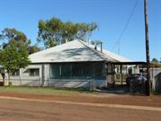
Constructed from 1900
The former Police Station House has historic significance for its association with law and order in Sandstone and its relationship with the adjacent Gaol building.
The former Police Station House is a timber framed building clad with corrugated iron. It has verandahs to all sides, the south west corner of which is enclosed with asbestos sheeting and lattice. The house has a medium pitched hipped roof, while the verandah roof to the east elevation is flat. Windows are timber framed and the building is surrounded by a corrugated iron fence.
Integrity: Medium Modifications: Verandahs partly enclosed with asbestos to south-west corner.
Good
| Owner | Category |
|---|---|
| Crown | UNKNOWN |
This information is provided voluntarily as a public service. The information provided is made available in good faith and is derived from sources believed to be reliable and accurate. However, the information is provided solely on the basis that readers will be responsible for making their own assessment of the matters discussed herein and are advised to verify all relevant representations, statements and information.
Oroya, Irvine, Griffith, Hack, Payne, Green and Thaduna Sts Sandstone
comprises National Hotel, former Warden's Court & Offices, Black Range Church, Post Office and Quarters, former School Teacher's House, former Police Quarters and Lockup, former Railway Goods Shed, house at 18 Thaduna Street, house at 97 Payne Street and Store.
Sandstone
Midwest
Constructed from 1907 to 1946
| Type | Status | Date | Documents |
|---|---|---|---|
| (no listings) |
| Type | Status | Date | Documents |
|---|---|---|---|
| RHP - Assessed - Deferred | Current | 22 Jul 2013 |
| Type | Status | Date | Grading/Management | |
|---|---|---|---|---|
| Category | ||||
| (no listings) | ||||
Sandstone Townsite Group, comprising a number of separate places located throughout the townsite and primarily built between 1908 and the 1920s. It is importance and rare as an extant Midwest mining town that has survived extreme periods of growth and decline. The sparse arrangement of the low-scale individual elements within a flat red-dirt landscape creates an evocative visual impression of the difficulties and remoteness of Western Australian goldfields life.
The group includes: National Hotel (1907), Warden's Court and Offices (fmr) (1908), Black Range Church (1908), Sandstone Post Office and Quarters (1909), School Teacher's House (fmr) (1910), Police Quarters (fmr) (1910), Railway Goods Shed (1910), and dwellings at 18 Thaduna Street (1922-23) 97 Payne Street (c.1929) and Store (1946).
The townsite of Sandstone was established in 1906 as the centre of major mining in the local area. The town rapidly developed with a great number of both government and private buildings being erected. The gold boom at Sandstone was however short lived and its population quickly declined in the 1910s and 1920s. A resurgence was experiences after World War II as the town benefitted from the wool boom.
Sandstone Townsite Group is generally in fair condition. Maintenance takes place on an as-needed basis to most places, but little maintenance or restoration work has taken place to the Goods Shed for many years.
| Name | Type | Year From | Year To |
|---|---|---|---|
| Public Works Department (PWD) | Architect | - | - |
| Library Id | Title | Medium | Year Of Publication |
|---|---|---|---|
| 7577 | Shire of Sandstone tank stand : structural condition report. | Heritage Study {Other} | 2005 |
Precinct or Streetscape
| Epoch | General | Specific |
|---|---|---|
| Original Use | RELIGIOUS | Church, Cathedral or Chapel |
| Original Use | COMMERCIAL | Hotel, Tavern or Inn |
| Original Use | Transport\Communications | Rail: Other |
| Original Use | GOVERNMENTAL | Police Station or Quarters |
| Original Use | COMMERCIAL | Shop\Retail Store {single} |
| Original Use | RESIDENTIAL | Single storey residence |
| Original Use | EDUCATIONAL | Combined School |
| Style |
|---|
| Vernacular |
| Federation Free Classical |
| Type | General | Specific |
|---|---|---|
| Wall | METAL | Corrugated Iron |
| Roof | METAL | Corrugated Iron |
| Other | TIMBER | Other Timber |
| Wall | BRICK | Common Brick |
| General | Specific |
|---|---|
| SOCIAL & CIVIC ACTIVITIES | Education & science |
| DEMOGRAPHIC SETTLEMENT & MOBILITY | Workers {incl. Aboriginal, convict} |
| DEMOGRAPHIC SETTLEMENT & MOBILITY | Resource exploitation & depletion |
| OCCUPATIONS | Hospitality industry & tourism |
| TRANSPORT & COMMUNICATIONS | Mail services |
| TRANSPORT & COMMUNICATIONS | Rail & light rail transport |
| SOCIAL & CIVIC ACTIVITIES | Law & order |
| SOCIAL & CIVIC ACTIVITIES | Community services & utilities |
| OCCUPATIONS | Mining {incl. mineral processing} |
| DEMOGRAPHIC SETTLEMENT & MOBILITY | Settlements |
| SOCIAL & CIVIC ACTIVITIES | Religion |
| OCCUPATIONS | Grazing, pastoralism & dairying |
This information is provided voluntarily as a public service. The information provided is made available in good faith and is derived from sources believed to be reliable and accurate. However, the information is provided solely on the basis that readers will be responsible for making their own assessment of the matters discussed herein and are advised to verify all relevant representations, statements and information.
Payne St Sandstone
Sandstone
Midwest
Constructed from 1975
| Type | Status | Date | Documents |
|---|---|---|---|
| (no listings) |
| Type | Status | Date | Documents |
|---|---|---|---|
| (no listings) |
| Type | Status | Date | Grading/Management | |
|---|---|---|---|---|
| Category | ||||
| Municipal Inventory | Adopted | 25 Jun 1997 | Category 4 | |
Individual Building or Group
| Epoch | General | Specific |
|---|---|---|
| Original Use | GOVERNMENTAL | Power Station |
| Present Use | GOVERNMENTAL | Power Station |
| Type | General | Specific |
|---|---|---|
| Wall | METAL | Steel |
| Roof | METAL | Steel |
| General | Specific |
|---|---|
| SOCIAL & CIVIC ACTIVITIES | Community services & utilities |
This information is provided voluntarily as a public service. The information provided is made available in good faith and is derived from sources believed to be reliable and accurate. However, the information is provided solely on the basis that readers will be responsible for making their own assessment of the matters discussed herein and are advised to verify all relevant representations, statements and information.
Constructed from 1975
The Power Station has high social significance given that it provides the town's power supply.
This large steel shed has a roller door to the east elevation which front onto the street. Three large mufflers are attached to the north facade. The Power Station is surrounded by a high fence.
The SEC Power Station was opened on 28 November, 1975 by Mr Mensaros, the Minister for Local Government.
Integrity: High Degree
Very Good
| Ref ID No | Ref Name | Ref Source | Ref Date |
|---|---|---|---|
| S Senior; "From Gold to Wool and Back Again". |
| Owner | Category |
|---|---|
| Crown Land | UNKNOWN |
This information is provided voluntarily as a public service. The information provided is made available in good faith and is derived from sources believed to be reliable and accurate. However, the information is provided solely on the basis that readers will be responsible for making their own assessment of the matters discussed herein and are advised to verify all relevant representations, statements and information.
97 Payne St Sandstone
Sandstone
Midwest
| Type | Status | Date | Documents |
|---|---|---|---|
| (no listings) |
| Type | Status | Date | Documents |
|---|---|---|---|
| RHP - Assessed - Deferred | Current | 22 Jul 2013 |
| Type | Status | Date | Grading/Management | |
|---|---|---|---|---|
| Category | ||||
| Municipal Inventory | Adopted | 25 Jun 1997 | Category 3 | |
02352 Sandstone Townsite Group
Individual Building or Group
| Epoch | General | Specific |
|---|---|---|
| Present Use | RESIDENTIAL | Single storey residence |
| Original Use | RESIDENTIAL | Single storey residence |
| Type | General | Specific |
|---|---|---|
| Roof | METAL | Corrugated Iron |
| Wall | METAL | Corrugated Iron |
| General | Specific |
|---|---|
| DEMOGRAPHIC SETTLEMENT & MOBILITY | Settlements |
This information is provided voluntarily as a public service. The information provided is made available in good faith and is derived from sources believed to be reliable and accurate. However, the information is provided solely on the basis that readers will be responsible for making their own assessment of the matters discussed herein and are advised to verify all relevant representations, statements and information.
Constructed from 1900
The house has historic significance as a transported house formerly associated with the mining settlement of Youanmi. The place also has considerable townscape quality given the scale and building materials incorporated.
This small timber framed cottage is clad with corrugated iron. The front verandah is now enclosed with corrugated iron sheeting. There is a rear lean-to roof and further corrugated iron structures located behind the house.
The house was formerly the Youanmi Buffalo Lodge. (Owner's Knowledge)
Integrity: Medium Degree Modifications: Verandah enclosed to front (west) elevation.
Good
| Owner | Category |
|---|---|
| B Walker | Other Private |
This information is provided voluntarily as a public service. The information provided is made available in good faith and is derived from sources believed to be reliable and accurate. However, the information is provided solely on the basis that readers will be responsible for making their own assessment of the matters discussed herein and are advised to verify all relevant representations, statements and information.
Sandstone Rd Sandstone
appears to be adjacent to P9124 Sandstone State Battery
Oroya Black Range Pty
Sandstone
Midwest
| Type | Status | Date | Documents |
|---|---|---|---|
| (no listings) |
| Type | Status | Date | Documents |
|---|---|---|---|
| (no listings) |
| Type | Status | Date | Grading/Management | |
|---|---|---|---|---|
| Category | ||||
| Mining Heritage Study | Adopted | 30 Jun 1999 | ||
Historic Site
| Epoch | General | Specific |
|---|---|---|
| Original Use | MINING | Mining Battery |
| Present Use | MINING | Mining Battery |
This information is provided voluntarily as a public service. The information provided is made available in good faith and is derived from sources believed to be reliable and accurate. However, the information is provided solely on the basis that readers will be responsible for making their own assessment of the matters discussed herein and are advised to verify all relevant representations, statements and information.
6km south-east of Sandstone on the Menzies-Sandstone Rd Sandstone
6km south-east of Sandstone on the Menzies-Sandstone Road, Sandstone
Sandstone
Midwest
Constructed from 1925, Constructed from 1904
| Type | Status | Date | Documents |
|---|---|---|---|
| State Register | Registered | 07 Sep 2006 | HCWebsite.Listing+ListingDocument, HCWebsite.Listing+ListingDocument |
| Type | Status | Date | Documents |
|---|---|---|---|
| (no listings) |
| Type | Status | Date | Grading/Management | |
|---|---|---|---|---|
| Category | ||||
| Municipal Inventory | Adopted | 25 Jun 1997 | Category 1 | |
State Battery (fmr), Sandstone is in fair to poor condition. Portions of the Battery are unsafe as structural members require repair and/or refixing. The place is being preserved by the Shire of Sandstone, as the Shire recognises its heritage value and the social significance of the place to the community.
| Library Id | Title | Medium | Year Of Publication |
|---|---|---|---|
| 6724 | Conservation plan for Sandstone State Battery (fmr) (1908), Sandstone, Western Australia. | Heritage Study {Cons'n Plan} | 2003 |
Individual Building or Group
| Epoch | General | Specific |
|---|---|---|
| Present Use | VACANT\UNUSED | Vacant\Unused |
| Original Use | MINING | Mining Battery |
| Style |
|---|
| Vernacular |
| Type | General | Specific |
|---|---|---|
| Wall | METAL | Corrugated Iron |
| Roof | METAL | Corrugated Iron |
| General | Specific |
|---|---|
| OCCUPATIONS | Mining {incl. mineral processing} |
| DEMOGRAPHIC SETTLEMENT & MOBILITY | Resource exploitation & depletion |
This information is provided voluntarily as a public service. The information provided is made available in good faith and is derived from sources believed to be reliable and accurate. However, the information is provided solely on the basis that readers will be responsible for making their own assessment of the matters discussed herein and are advised to verify all relevant representations, statements and information.
Constructed from 1904, Constructed from 1925
The former State Battery has high historic significance for its essential role in the mining industry in the Sandstone district. The place has further significance given that much of the machinery is still intact.
A large timber framed structure which is clad with corrugated iron. It contains a five head stamper, a diesel engine with a large generator, a cooling system attached to the southern facade and other machinery inside. There is evidence of white ant damage. There is a wire fence running around the perimeter of the Battery.
A State Battery was established at Sandstone by removing one which had fallen into disuse at Paynesville, about 80km west of Sandstone. Andrew Irvine was appointed the first manager of the Battery and was responsible for its dismantling and removal to the new site, which was a small distance west of the present location. Teams of horses, donkeys and bullocks were used to transport the Battery in early 1904. Irvine collapsed and died on April 10, just prior to its completion. The Battery was moved to its present site in 1925. Initially it was operated by coking local wood, but was later converted to diesel power. During its working life a total of 135, 809 tons of ore were treated here, producing 115, 787 ounces of bullion. The Battery closed in 1982.
Integrity: High Degree
Fair
| Ref ID No | Ref Name | Ref Source | Ref Date |
|---|---|---|---|
| "Sandstone Heritage Trail brochure". |
| Owner | Category |
|---|---|
| Department for Planning & Infrastructure | State Gov't |
This information is provided voluntarily as a public service. The information provided is made available in good faith and is derived from sources believed to be reliable and accurate. However, the information is provided solely on the basis that readers will be responsible for making their own assessment of the matters discussed herein and are advised to verify all relevant representations, statements and information.
18 Thaduna St Sandstone
Sandstone
Midwest
| Type | Status | Date | Documents |
|---|---|---|---|
| (no listings) |
| Type | Status | Date | Documents |
|---|---|---|---|
| RHP - Assessed - Deferred | Current | 22 Jul 2013 |
| Type | Status | Date | Grading/Management | |
|---|---|---|---|---|
| Category | ||||
| Municipal Inventory | Adopted | 25 Jun 1997 | Category 3 | |
02352 Sandstone Townsite Group
Individual Building or Group
| Epoch | General | Specific |
|---|---|---|
| Original Use | RESIDENTIAL | Single storey residence |
| Present Use | RESIDENTIAL | Single storey residence |
| Type | General | Specific |
|---|---|---|
| Roof | METAL | Corrugated Iron |
| Wall | METAL | Corrugated Iron |
| General | Specific |
|---|---|
| DEMOGRAPHIC SETTLEMENT & MOBILITY | Settlements |
This information is provided voluntarily as a public service. The information provided is made available in good faith and is derived from sources believed to be reliable and accurate. However, the information is provided solely on the basis that readers will be responsible for making their own assessment of the matters discussed herein and are advised to verify all relevant representations, statements and information.
If verified, the house has historic significance as one of the first residences built in Sandstone. The building materials are representative of those used throughout the region. The place has considerable townscape value, given its corner location and the aesthetic charm it displays.
This small timber framed cottage is entirely clad with corrugated iron and features a verandah to the front (west) elevation and a rear lean-to roof. It has a steeply pitched gable roof and lean to verandah roof. Two metal chimneys are attached to the southern elevation.
This house is said to be one of the first residences built in Sandstone. (Local Knowledge).
Integrity: High Degree
Fair
| Owner | Category |
|---|---|
| JW Reid | Other Private |
This information is provided voluntarily as a public service. The information provided is made available in good faith and is derived from sources believed to be reliable and accurate. However, the information is provided solely on the basis that readers will be responsible for making their own assessment of the matters discussed herein and are advised to verify all relevant representations, statements and information.