Local Government
Sandstone
Region
Midwest
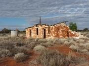
Anketell
Sandstone
Midwest
Constructed from 1909
| Type | Status | Date | Documents |
|---|---|---|---|
| (no listings) |
| Type | Status | Date | Documents |
|---|---|---|---|
| (no listings) |
| Type | Status | Date | Grading/Management | |
|---|---|---|---|---|
| Category | ||||
| Municipal Inventory | Adopted | 25 Jun 1997 | Category 3 | |
Individual Building or Group
| Epoch | General | Specific |
|---|---|---|
| Original Use | Transport\Communications | Rail: Other |
| Present Use | VACANT\UNUSED | Vacant\Unused |
| General | Specific |
|---|---|
| TRANSPORT & COMMUNICATIONS | Rail & light rail transport |
This information is provided voluntarily as a public service. The information provided is made available in good faith and is derived from sources believed to be reliable and accurate. However, the information is provided solely on the basis that readers will be responsible for making their own assessment of the matters discussed herein and are advised to verify all relevant representations, statements and information.
Constructed from 1909
The Anketell Siding has historic significance for its association with the railway line between Mount Magnet and Sandstone which had a very important role in the development of the Sandstone district.
Construction on the railway between Mount Magnet and Sandstone commenced in 1909. The line was opened for use the following year and closed in 1949.
This information is provided voluntarily as a public service. The information provided is made available in good faith and is derived from sources believed to be reliable and accurate. However, the information is provided solely on the basis that readers will be responsible for making their own assessment of the matters discussed herein and are advised to verify all relevant representations, statements and information.
Atley Station
Sandstone
Midwest
| Type | Status | Date | Documents |
|---|---|---|---|
| (no listings) |
| Type | Status | Date | Documents |
|---|---|---|---|
| (no listings) |
| Type | Status | Date | Grading/Management | |
|---|---|---|---|---|
| Category | ||||
| Municipal Inventory | Adopted | 25 Jun 1997 | Category 3 | |
Historic site
| Epoch | General | Specific |
|---|---|---|
| Original Use | FARMING\PASTORAL | Other |
| Present Use | SOCIAL\RECREATIONAL | Other |
| General | Specific |
|---|---|
| SOCIAL & CIVIC ACTIVITIES | Sport, recreation & entertainment |
| OCCUPATIONS | Grazing, pastoralism & dairying |
This information is provided voluntarily as a public service. The information provided is made available in good faith and is derived from sources believed to be reliable and accurate. However, the information is provided solely on the basis that readers will be responsible for making their own assessment of the matters discussed herein and are advised to verify all relevant representations, statements and information.
The old Stock Yards have historic significance for their association with the pastoral industry in the Sandstone district.
| Owner | Category |
|---|---|
| Crown Land | UNKNOWN |
This information is provided voluntarily as a public service. The information provided is made available in good faith and is derived from sources believed to be reliable and accurate. However, the information is provided solely on the basis that readers will be responsible for making their own assessment of the matters discussed herein and are advised to verify all relevant representations, statements and information.
Sandstone Rd Barrambie
Sandstone
Midwest
| Type | Status | Date | Documents |
|---|---|---|---|
| (no listings) |
| Type | Status | Date | Documents |
|---|---|---|---|
| (no listings) |
| Type | Status | Date | Grading/Management | |
|---|---|---|---|---|
| Category | ||||
| Mining Heritage Study | Adopted | 30 Jun 1999 | ||
Historic Site
| Epoch | General | Specific |
|---|---|---|
| Original Use | MINING | Mining Battery |
| Present Use | MINING | Mining Battery |
This information is provided voluntarily as a public service. The information provided is made available in good faith and is derived from sources believed to be reliable and accurate. However, the information is provided solely on the basis that readers will be responsible for making their own assessment of the matters discussed herein and are advised to verify all relevant representations, statements and information.
Lake Mason
Includes Homestead, fmr kitchen and Shearing Shed
Sandstone
Midwest
| Type | Status | Date | Documents |
|---|---|---|---|
| (no listings) |
| Type | Status | Date | Documents |
|---|---|---|---|
| (no listings) |
| Type | Status | Date | Grading/Management | |
|---|---|---|---|---|
| Category | ||||
| (no listings) | ||||
Individual Building or Group
| Epoch | General | Specific |
|---|---|---|
| Original Use | FARMING\PASTORAL | Homestead |
This information is provided voluntarily as a public service. The information provided is made available in good faith and is derived from sources believed to be reliable and accurate. However, the information is provided solely on the basis that readers will be responsible for making their own assessment of the matters discussed herein and are advised to verify all relevant representations, statements and information.
Sandstone Rd Montague
Sandstone
Midwest
| Type | Status | Date | Documents |
|---|---|---|---|
| (no listings) |
| Type | Status | Date | Documents |
|---|---|---|---|
| (no listings) |
| Type | Status | Date | Grading/Management | |
|---|---|---|---|---|
| Category | ||||
| Mining Heritage Study | Adopted | 30 Jun 1999 | ||
Historic Site
| Epoch | General | Specific |
|---|---|---|
| Original Use | MINING | Mining Battery |
| Present Use | MINING | Mining Battery |
This information is provided voluntarily as a public service. The information provided is made available in good faith and is derived from sources believed to be reliable and accurate. However, the information is provided solely on the basis that readers will be responsible for making their own assessment of the matters discussed herein and are advised to verify all relevant representations, statements and information.
Pt Hedland to Ravensthorpe
Goes through the following LGAs: Port Hedland, East Pilbara, Wiluna, Meekatharra, Cue, Mt Magnet, Yalgoo, Sandstone, Menzies, Yilgarn, Ravensthorpe, Mt Marshall, Mukinbudin, Westonia, Merredin, Narembeen, Kondinin, Kulin, Lake Grace, Quairading
Cue
Midwest
Constructed from 1906
| Type | Status | Date | Documents |
|---|---|---|---|
| (no listings) |
| Type | Status | Date | Documents |
|---|---|---|---|
| RHP - To be assessed | Current | 25 Nov 2005 |
| Type | Status | Date | Grading/Management | |
|---|---|---|---|---|
| Category | ||||
| (no listings) | ||||
The place is the longest fence in the world, extending over 1800kms.
The place is significant for its contribution to agriculture at the turn of the century.
The place is rare as a method of pest control, that was to eventually also help prevent the movement of dingoes, foxes and emus.
The Rabbit Proof Fence is the longest fence in the world and cost £250 per kilometre to construct. It was made from Saltwater paperbark posts, wire netting 42 inches wide, with a mesh not less than 1 1/2 inches, and no lighter than 17 gauge, ‘b’ grade with barbed and plain wire. Six inches of the erected wire netting was buried in the ground.
Rabbits were introduced to Geelong from England by Thomas Austin in 1859. Towards the end of the last century rabbits were known to have travelled across to Western Australia from Victoria. In 1896, Arthur Gregory Mason reported that rabbits were at least two hundred miles past the South Australian border and inside Western Australia at the town of Eucla. His recommendation to the government was to build a rabbit proof fence. After much debate and a Royal Commission, the government eventually adopted the idea of a barrier fence. In 1901 the Government Surveyor, A.W. Canning was commissioned to survey a fence line to be built to cut off the flow of rabbits entering Western Australia. Canning with only Hubert Trotman, Hassan (an Afghan Camel man) and eight camels completed the preliminary exploratory survey from Burracoppin to Starvation Boat Harbour in July and August that year. They surveyed a route for the fence and its construction began in December the same year. The fence from Starvation Boat Harbour to Burracoppin was built by contract with saltwater paperbark posts on the lower section obtained locally and other materials were shipped into starvation Boat Harbour. The fence was completed in 1906. When the fence was completed, it was the longest fence in the world, stretching from Starvation Boat Harbour, just west of Esperance in the south, to Wallal on the 80 Mile Beach in the northwest, a distance of 1822kms. Even before completion, the rabbits were past the fence and work had begun on Fences No.2 and 3. By 1908 the three fences were complete, over 3,000km of fence line in total. (See map.) Although the construction of the fences was finished, someone was needed to patrol and maintain them. Alex Crawford was appointed the first Chief Inspector of Rabbits and was required to inspect and maintain the fences. The fence was maintained by boundary riders patrolling 240km stretches of fence line with an ingenuous permanent water catchments and huts at regular intervals of 50kms. There were gates at every 32kms and trap yards for foxes and dingoes as well as rabbits every 8 kms. Grids and rabbit proof gates were constructed where the fence crossed the road. Without regular water, the use of horses to carry out the fence inspection was difficult. When camels were used, it was found that inspection of the fence was unsatisfactory from the height of a camel. Many other methods were tried such as bicycles, but this proved unsatisfactory. In 1910, a motor vehicle was purchased to carry out the inspection but was also to prove unsatisfactory. After many punctures and broken springs, it had to be towed slowly back to camp by camels. In the end the only workable solution for the inspection teams were buckboard buggies pulled by pairs of camels. Despite the best efforts to stop the rabbits at the barrier fence, it was to only slow the rabbit's migration. Erosion under the fences, holes in the wire and gates left open allowed rabbits to continue their movement west into the fertile agricultural areas. In their hundreds of thousands, they ate out pasture, ring-barked trees and devoured crops. Much of the fence is still in good repair, especially where it is used by abutting farmers as a boundary fence.
Integrity- Moderate Authenticity- High
Good - although condition varies along the route
Historic site
| Epoch | General | Specific |
|---|---|---|
| Original Use | FARMING\PASTORAL | Other |
| Present Use | FARMING\PASTORAL | Other |
| Type | General | Specific |
|---|---|---|
| Wall | METAL | Other Metal |
| General | Specific |
|---|---|
| PEOPLE | Early settlers |
This information is provided voluntarily as a public service. The information provided is made available in good faith and is derived from sources believed to be reliable and accurate. However, the information is provided solely on the basis that readers will be responsible for making their own assessment of the matters discussed herein and are advised to verify all relevant representations, statements and information.
Sandstone
Sandstone
Midwest
| Type | Status | Date | Documents |
|---|---|---|---|
| (no listings) |
| Type | Status | Date | Documents |
|---|---|---|---|
| (no listings) |
| Type | Status | Date | Grading/Management | |
|---|---|---|---|---|
| Category | ||||
| Municipal Inventory | Adopted | 25 Jun 1997 | ||
Individual Building or Group
| Epoch | General | Specific |
|---|---|---|
| Original Use | FARMING\PASTORAL | Homestead |
| Present Use | FARMING\PASTORAL | Homestead |
| General | Specific |
|---|---|
| OCCUPATIONS | Grazing, pastoralism & dairying |
This information is provided voluntarily as a public service. The information provided is made available in good faith and is derived from sources believed to be reliable and accurate. However, the information is provided solely on the basis that readers will be responsible for making their own assessment of the matters discussed herein and are advised to verify all relevant representations, statements and information.
Atley Station has historic significance for its association with the pastoral industry in the Sandstone district.
| Owner | Category |
|---|---|
| Crown Land | UNKNOWN |
This information is provided voluntarily as a public service. The information provided is made available in good faith and is derived from sources believed to be reliable and accurate. However, the information is provided solely on the basis that readers will be responsible for making their own assessment of the matters discussed herein and are advised to verify all relevant representations, statements and information.
Sandstone
Sandstone
Midwest
Constructed from 1905
| Type | Status | Date | Documents |
|---|---|---|---|
| (no listings) |
| Type | Status | Date | Documents |
|---|---|---|---|
| (no listings) |
| Type | Status | Date | Grading/Management | |
|---|---|---|---|---|
| Category | ||||
| Municipal Inventory | Adopted | 25 Jun 1997 | Category 5 | |
Historic site
| Epoch | General | Specific |
|---|---|---|
| Original Use | Transport\Communications | Road: Other |
| Present Use | Transport\Communications | Road: Other |
| General | Specific |
|---|---|
| TRANSPORT & COMMUNICATIONS | Road transport |
This information is provided voluntarily as a public service. The information provided is made available in good faith and is derived from sources believed to be reliable and accurate. However, the information is provided solely on the basis that readers will be responsible for making their own assessment of the matters discussed herein and are advised to verify all relevant representations, statements and information.
Constructed from 1905
The Barrambie to Lawlers Road has historic significance for its association with early transportation across the Sandstone district. It made the district more accessible and allowed for increased communications between the mining settlements.
This road provided a much needed access way across the district between the mining settlements of Barrambie and Lawlers.
Site Only
This information is provided voluntarily as a public service. The information provided is made available in good faith and is derived from sources believed to be reliable and accurate. However, the information is provided solely on the basis that readers will be responsible for making their own assessment of the matters discussed herein and are advised to verify all relevant representations, statements and information.
Sandstone
Gidgee Homestead
Sandstone
Midwest
| Type | Status | Date | Documents |
|---|---|---|---|
| (no listings) |
| Type | Status | Date | Documents |
|---|---|---|---|
| (no listings) |
| Type | Status | Date | Grading/Management | |
|---|---|---|---|---|
| Category | ||||
| Municipal Inventory | Adopted | 25 Jun 1997 | Category 3 | |
Individual Building or Group
| Epoch | General | Specific |
|---|---|---|
| Present Use | FARMING\PASTORAL | Homestead |
| Original Use | COMMERCIAL | Hotel, Tavern or Inn |
| General | Specific |
|---|---|
| OCCUPATIONS | Grazing, pastoralism & dairying |
| OCCUPATIONS | Hospitality industry & tourism |
This information is provided voluntarily as a public service. The information provided is made available in good faith and is derived from sources believed to be reliable and accurate. However, the information is provided solely on the basis that readers will be responsible for making their own assessment of the matters discussed herein and are advised to verify all relevant representations, statements and information.
The former Birrigrin Hotel has historic significance for its role as a traveller's inn, local recreation place and later as the Gidgee Homestead.
The Gidgee Homestead was the original Birrigrin Hotel.
| Owner | Category |
|---|---|
| Crown Land | Commonwealth Gov't |
This information is provided voluntarily as a public service. The information provided is made available in good faith and is derived from sources believed to be reliable and accurate. However, the information is provided solely on the basis that readers will be responsible for making their own assessment of the matters discussed herein and are advised to verify all relevant representations, statements and information.
Sandstone
Calulyu Station
Sandstone
Midwest
| Type | Status | Date | Documents |
|---|---|---|---|
| (no listings) |
| Type | Status | Date | Documents |
|---|---|---|---|
| (no listings) |
| Type | Status | Date | Grading/Management | |
|---|---|---|---|---|
| Category | ||||
| Municipal Inventory | Adopted | 25 Jun 1997 | ||
Individual Building or Group
| Epoch | General | Specific |
|---|---|---|
| Original Use | FARMING\PASTORAL | Homestead |
| Present Use | FARMING\PASTORAL | Homestead |
| General | Specific |
|---|---|
| OCCUPATIONS | Grazing, pastoralism & dairying |
This information is provided voluntarily as a public service. The information provided is made available in good faith and is derived from sources believed to be reliable and accurate. However, the information is provided solely on the basis that readers will be responsible for making their own assessment of the matters discussed herein and are advised to verify all relevant representations, statements and information.
Calulya Station has historic significance for its association with the pastoral industry in the Sandstone district.
| Owner | Category |
|---|---|
| Crown Land | UNKNOWN |
This information is provided voluntarily as a public service. The information provided is made available in good faith and is derived from sources believed to be reliable and accurate. However, the information is provided solely on the basis that readers will be responsible for making their own assessment of the matters discussed herein and are advised to verify all relevant representations, statements and information.
Sandstone
Dromedary Hills, 10 km east of intersection Narndee - Red Bluff Rd and Paynes Find Sandstone Rd on the western side of the Rabbit Proof Fence
Sandstone
Midwest
Constructed from 1930
| Type | Status | Date | Documents |
|---|---|---|---|
| State Register | Registered | 31 Aug 2018 | HCWebsite.Listing+ListingDocument, HCWebsite.Listing+ListingDocument |
| Type | Status | Date | Documents |
|---|---|---|---|
| (no listings) |
| Type | Status | Date | Grading/Management | |
|---|---|---|---|---|
| Category | ||||
| (no listings) | ||||
Individual Building or Group
| Epoch | General | Specific |
|---|---|---|
| Original Use | RESIDENTIAL | Single storey residence |
| Present Use | VACANT\UNUSED | Vacant\Unused |
| Type | General | Specific |
|---|---|---|
| Wall | STONE | Local Stone |
This information is provided voluntarily as a public service. The information provided is made available in good faith and is derived from sources believed to be reliable and accurate. However, the information is provided solely on the basis that readers will be responsible for making their own assessment of the matters discussed herein and are advised to verify all relevant representations, statements and information.
Sandstone
Sandstone
Midwest
| Type | Status | Date | Documents |
|---|---|---|---|
| (no listings) |
| Type | Status | Date | Documents |
|---|---|---|---|
| (no listings) |
| Type | Status | Date | Grading/Management | |
|---|---|---|---|---|
| Category | ||||
| (no listings) | ||||
Individual Building or Group
| Epoch | General | Specific |
|---|---|---|
| Present Use | FARMING\PASTORAL | Homestead |
| Original Use | FARMING\PASTORAL | Homestead |
| General | Specific |
|---|---|
| OCCUPATIONS | Grazing, pastoralism & dairying |
This information is provided voluntarily as a public service. The information provided is made available in good faith and is derived from sources believed to be reliable and accurate. However, the information is provided solely on the basis that readers will be responsible for making their own assessment of the matters discussed herein and are advised to verify all relevant representations, statements and information.
Sandstone
Sandstone
Midwest
| Type | Status | Date | Documents |
|---|---|---|---|
| (no listings) |
| Type | Status | Date | Documents |
|---|---|---|---|
| (no listings) |
| Type | Status | Date | Grading/Management | |
|---|---|---|---|---|
| Category | ||||
| Municipal Inventory | Adopted | 25 Jun 1997 | ||
Historic site
| Epoch | General | Specific |
|---|---|---|
| Present Use | SOCIAL\RECREATIONAL | Other |
| Original Use | FARMING\PASTORAL | Other |
| General | Specific |
|---|---|
| SOCIAL & CIVIC ACTIVITIES | Sport, recreation & entertainment |
| OCCUPATIONS | Grazing, pastoralism & dairying |
This information is provided voluntarily as a public service. The information provided is made available in good faith and is derived from sources believed to be reliable and accurate. However, the information is provided solely on the basis that readers will be responsible for making their own assessment of the matters discussed herein and are advised to verify all relevant representations, statements and information.
Depot Springs has historic significance for its association with the pastoral industry in the Sandstone district. The place has further social significance as a favourite place for picnics for the local community.
| Owner | Category |
|---|---|
| Crown Land | Commonwealth Gov't |
This information is provided voluntarily as a public service. The information provided is made available in good faith and is derived from sources believed to be reliable and accurate. However, the information is provided solely on the basis that readers will be responsible for making their own assessment of the matters discussed herein and are advised to verify all relevant representations, statements and information.
Sandstone
Sandstone
Midwest
Constructed from 1895
| Type | Status | Date | Documents |
|---|---|---|---|
| (no listings) |
| Type | Status | Date | Documents |
|---|---|---|---|
| (no listings) |
| Type | Status | Date | Grading/Management | |
|---|---|---|---|---|
| Category | ||||
| Municipal Inventory | Adopted | 25 Jun 1997 | Category 2 | |
Historic site
| Epoch | General | Specific |
|---|---|---|
| Present Use | VACANT\UNUSED | Vacant\Unused |
| Original Use | MINING | Other |
| General | Specific |
|---|---|
| OCCUPATIONS | Mining {incl. mineral processing} |
This information is provided voluntarily as a public service. The information provided is made available in good faith and is derived from sources believed to be reliable and accurate. However, the information is provided solely on the basis that readers will be responsible for making their own assessment of the matters discussed herein and are advised to verify all relevant representations, statements and information.
Constructed from 1895
The Ivy Linden has high historic significance as the site of the first registered mineral claim in the Sandstone district.
On 2 January, 1895 the first mineral claim was registered. The Reward Claim 387/95 later became known as the 'Ivy Linden'.
This information is provided voluntarily as a public service. The information provided is made available in good faith and is derived from sources believed to be reliable and accurate. However, the information is provided solely on the basis that readers will be responsible for making their own assessment of the matters discussed herein and are advised to verify all relevant representations, statements and information.
Sandstone
located 34km west of Sandstone
Sandstone
Midwest
| Type | Status | Date | Documents |
|---|---|---|---|
| (no listings) |
| Type | Status | Date | Documents |
|---|---|---|---|
| (no listings) |
| Type | Status | Date | Grading/Management | |
|---|---|---|---|---|
| Category | ||||
| Municipal Inventory | Adopted | 25 Jun 1997 | Category 3 | |
Historic site
| Epoch | General | Specific |
|---|---|---|
| Present Use | GOVERNMENTAL | Reservoir or Dam |
| Original Use | GOVERNMENTAL | Reservoir or Dam |
| General | Specific |
|---|---|
| TRANSPORT & COMMUNICATIONS | Rail & light rail transport |
This information is provided voluntarily as a public service. The information provided is made available in good faith and is derived from sources believed to be reliable and accurate. However, the information is provided solely on the basis that readers will be responsible for making their own assessment of the matters discussed herein and are advised to verify all relevant representations, statements and information.
Constructed from 1909
The Jundoo Dam has historic significance for its association with the Mount Magnet-Sandstone railway line. It has further social significance as a popular recreational destination for local Sandstone residents.
Situated approximately 34 kms west of Sandstone, the Jundoo Dam is a large earth dam which, at the time of assessment was full of water from recent rains. The dam has a long slip way which extends to a nearby creek which had a barrier to divert water into the dam. There was a timber jetty which extended from the west side of the dam however no evidence of it remains.
The Jundoo Dam provided a water supply for the steam trains on the Mount Magnet-Sandstone railway line. Over the years the Dam has been a very popular picnic spot.
Integrity: High Degree
Good
This information is provided voluntarily as a public service. The information provided is made available in good faith and is derived from sources believed to be reliable and accurate. However, the information is provided solely on the basis that readers will be responsible for making their own assessment of the matters discussed herein and are advised to verify all relevant representations, statements and information.
Sandstone
Sandstone
Midwest
| Type | Status | Date | Documents |
|---|---|---|---|
| (no listings) |
| Type | Status | Date | Documents |
|---|---|---|---|
| (no listings) |
| Type | Status | Date | Grading/Management | |
|---|---|---|---|---|
| Category | ||||
| Municipal Inventory | Adopted | 25 Jun 1997 | ||
Individual Building or Group
| Epoch | General | Specific |
|---|---|---|
| Present Use | FARMING\PASTORAL | Homestead |
| Original Use | FARMING\PASTORAL | Homestead |
| General | Specific |
|---|---|
| OCCUPATIONS | Grazing, pastoralism & dairying |
This information is provided voluntarily as a public service. The information provided is made available in good faith and is derived from sources believed to be reliable and accurate. However, the information is provided solely on the basis that readers will be responsible for making their own assessment of the matters discussed herein and are advised to verify all relevant representations, statements and information.
Kaluwiri Station has historic significance for its association with the pastoral industry in the Sandstone district.
This information is provided voluntarily as a public service. The information provided is made available in good faith and is derived from sources believed to be reliable and accurate. However, the information is provided solely on the basis that readers will be responsible for making their own assessment of the matters discussed herein and are advised to verify all relevant representations, statements and information.
Sandstone
Sandstone
Midwest
| Type | Status | Date | Documents |
|---|---|---|---|
| (no listings) |
| Type | Status | Date | Documents |
|---|---|---|---|
| (no listings) |
| Type | Status | Date | Grading/Management | |
|---|---|---|---|---|
| Category | ||||
| Municipal Inventory | Adopted | 25 Jun 1997 | Category 3 | |
Landscape
| General | Specific |
|---|---|
| DEMOGRAPHIC SETTLEMENT & MOBILITY | Exploration & surveying |
This information is provided voluntarily as a public service. The information provided is made available in good faith and is derived from sources believed to be reliable and accurate. However, the information is provided solely on the basis that readers will be responsible for making their own assessment of the matters discussed herein and are advised to verify all relevant representations, statements and information.
Lake Mason has historic significance for its association with the explorer, H.G. Mason.
This information is provided voluntarily as a public service. The information provided is made available in good faith and is derived from sources believed to be reliable and accurate. However, the information is provided solely on the basis that readers will be responsible for making their own assessment of the matters discussed herein and are advised to verify all relevant representations, statements and information.
Sandstone
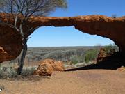
The Devil's Arch
Sandstone
Midwest
| Type | Status | Date | Documents |
|---|---|---|---|
| (no listings) |
| Type | Status | Date | Documents |
|---|---|---|---|
| (no listings) |
| Type | Status | Date | Grading/Management | |
|---|---|---|---|---|
| Category | ||||
| Municipal Inventory | Adopted | 25 Jun 1997 | Category 2 | |
Geological monument
| Epoch | General | Specific |
|---|---|---|
| Present Use | SOCIAL\RECREATIONAL | Other |
| Original Use | SOCIAL\RECREATIONAL | Other |
| Type | General | Specific |
|---|---|---|
| Other | STONE | Other Stone |
| General | Specific |
|---|---|
| SOCIAL & CIVIC ACTIVITIES | Sport, recreation & entertainment |
This information is provided voluntarily as a public service. The information provided is made available in good faith and is derived from sources believed to be reliable and accurate. However, the information is provided solely on the basis that readers will be responsible for making their own assessment of the matters discussed herein and are advised to verify all relevant representations, statements and information.
Constructed from 1900
London Bridge has some social and historic significance as both a local natural attraction yid place for socialising.
'London Bridge' is a formation large enough for vehicles to pass underneath. It is part of a larger formation about 800 metres long, vary ing in height from around three to ten metres. It is formed of weathered basalt and the rock is believed to be about 350 million years old.
Many wild drinking parties were held here after the establishment of the local brewery nearby and consequently the bridge was also commonly known as 'the Devil's Arch'. It was also a popular picnic spot for locals.
| Ref ID No | Ref Name | Ref Source | Ref Date |
|---|---|---|---|
| "Sandstone Heritage Trail brochure". |
This information is provided voluntarily as a public service. The information provided is made available in good faith and is derived from sources believed to be reliable and accurate. However, the information is provided solely on the basis that readers will be responsible for making their own assessment of the matters discussed herein and are advised to verify all relevant representations, statements and information.
Sandstone
Dandaraga Station
Sandstone
Midwest
Constructed from 1918
| Type | Status | Date | Documents |
|---|---|---|---|
| (no listings) |
| Type | Status | Date | Documents |
|---|---|---|---|
| (no listings) |
| Type | Status | Date | Grading/Management | |
|---|---|---|---|---|
| Category | ||||
| Municipal Inventory | Adopted | 25 Jun 1997 | Category 5 | |
Historic Site
| Epoch | General | Specific |
|---|---|---|
| Original Use | OTHER | Other |
| Other Use | VACANT\UNUSED | Vacant\Unused |
| General | Specific |
|---|---|
| DEMOGRAPHIC SETTLEMENT & MOBILITY | Settlements |
This information is provided voluntarily as a public service. The information provided is made available in good faith and is derived from sources believed to be reliable and accurate. However, the information is provided solely on the basis that readers will be responsible for making their own assessment of the matters discussed herein and are advised to verify all relevant representations, statements and information.
The Maninga Marley Townsite has historic significance for its role in the development of the Shire.
The townsite of Maninga Marley developed due to its proximity to several mine sites.
Site Only
| Owner | Category |
|---|---|
| Crown Land | Commonwealth Gov't |
This information is provided voluntarily as a public service. The information provided is made available in good faith and is derived from sources believed to be reliable and accurate. However, the information is provided solely on the basis that readers will be responsible for making their own assessment of the matters discussed herein and are advised to verify all relevant representations, statements and information.
Sandstone
Sandstone
Midwest
Constructed from 1905
| Type | Status | Date | Documents |
|---|---|---|---|
| (no listings) |
| Type | Status | Date | Documents |
|---|---|---|---|
| (no listings) |
| Type | Status | Date | Grading/Management | |
|---|---|---|---|---|
| Category | ||||
| Municipal Inventory | Adopted | 25 Jun 1997 | Category 5 | |
Historic site
| Epoch | General | Specific |
|---|---|---|
| Present Use | Transport\Communications | Road: Other |
| Original Use | Transport\Communications | Road: Other |
| General | Specific |
|---|---|
| TRANSPORT & COMMUNICATIONS | Road transport |
This information is provided voluntarily as a public service. The information provided is made available in good faith and is derived from sources believed to be reliable and accurate. However, the information is provided solely on the basis that readers will be responsible for making their own assessment of the matters discussed herein and are advised to verify all relevant representations, statements and information.
Constructed from 1905
The Mount Magnet to Lawlers Coach Route has historic significance for its association with early transportation across the Sandstone district. It made the district more accessible and allowed for increased communications between the towns.
Constructed in the early 1900s when the gold rushes were underway in the Sandstone and the goldfields, this coach route provided a much needed access way across the district. It was used by prospectors, miners, pastoral settlers, bullock, camel and horse team drivers and those travelling through the area whether on horse, on foot, in a sulky or on a bicycle. A number of wells provided watering spots along the way.
Site Only
This information is provided voluntarily as a public service. The information provided is made available in good faith and is derived from sources believed to be reliable and accurate. However, the information is provided solely on the basis that readers will be responsible for making their own assessment of the matters discussed herein and are advised to verify all relevant representations, statements and information.