Local Government
Sandstone
Region
Midwest
Sandstone
Sandstone
Midwest
Constructed from 1907
| Type | Status | Date | Documents |
|---|---|---|---|
| (no listings) |
| Type | Status | Date | Documents |
|---|---|---|---|
| (no listings) |
| Type | Status | Date | Grading/Management | |
|---|---|---|---|---|
| Category | ||||
| Municipal Inventory | Adopted | 25 Jun 1997 | Category 5 | |
Historic site
| Epoch | General | Specific |
|---|---|---|
| Present Use | Transport\Communications | Comms: Other |
| Original Use | Transport\Communications | Comms: Other |
| General | Specific |
|---|---|
| TRANSPORT & COMMUNICATIONS | Telecommunications |
This information is provided voluntarily as a public service. The information provided is made available in good faith and is derived from sources believed to be reliable and accurate. However, the information is provided solely on the basis that readers will be responsible for making their own assessment of the matters discussed herein and are advised to verify all relevant representations, statements and information.
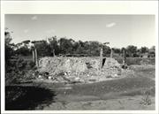
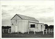
Constructed from 1907
The Mount Magnet to Sandstone Telegraph Line has historic significance for its association with early communications throughout the Sandstone district.
The Mount Magnet to Nungarra telegraph line was surveyed in January 1907. By 1909 Sandstone had its own Post and Telegraph Office and presumably the telegraph line was extended to the town at this time. [Site No. 3]
Site Only
| Ref ID No | Ref Name | Ref Source | Ref Date |
|---|---|---|---|
| WE Gaynor; "The History of Sandstone". |
This information is provided voluntarily as a public service. The information provided is made available in good faith and is derived from sources believed to be reliable and accurate. However, the information is provided solely on the basis that readers will be responsible for making their own assessment of the matters discussed herein and are advised to verify all relevant representations, statements and information.
Sandstone
Nunngarra Townsite (Site)
Sandstone
Midwest
Constructed from 1904
| Type | Status | Date | Documents |
|---|---|---|---|
| (no listings) |
| Type | Status | Date | Documents |
|---|---|---|---|
| (no listings) |
| Type | Status | Date | Grading/Management | |
|---|---|---|---|---|
| Category | ||||
| Municipal Inventory | Adopted | 25 Jun 1997 | Category 5 | |
Historic Site
| Epoch | General | Specific |
|---|---|---|
| Present Use | VACANT\UNUSED | Vacant\Unused |
| Original Use | OTHER | Other |
| General | Specific |
|---|---|
| DEMOGRAPHIC SETTLEMENT & MOBILITY | Settlements |
| OCCUPATIONS | Mining {incl. mineral processing} |
This information is provided voluntarily as a public service. The information provided is made available in good faith and is derived from sources believed to be reliable and accurate. However, the information is provided solely on the basis that readers will be responsible for making their own assessment of the matters discussed herein and are advised to verify all relevant representations, statements and information.
The Nungarra Townsite has historic significance as the first settlement in the Sandstone district.
The first settlement in the Sandstone district was Nungarra, which was established as the prospecting settlement of the 'Black Range' area, as Sandstone was originally known. The town, which boasted many buildings including three hotels, stores and a branch of the Western Australian Bank, was gazetted in 1904. However, by 1906 it had become apparent that this was not the best site for the town. Not only was there insufficient water for the growing population, many of the miners were choosing to live about 10km to the north-east where larger and richer mines were opening up. This area became known as Sandstone, the town of which was gazetted in September, 1906. Many of the buildings in Nungarra were moved into the new town.
Site Only
This information is provided voluntarily as a public service. The information provided is made available in good faith and is derived from sources believed to be reliable and accurate. However, the information is provided solely on the basis that readers will be responsible for making their own assessment of the matters discussed herein and are advised to verify all relevant representations, statements and information.
Sandstone
Contradiction Well
Sandstone
Midwest
| Type | Status | Date | Documents |
|---|---|---|---|
| (no listings) |
| Type | Status | Date | Documents |
|---|---|---|---|
| (no listings) |
| Type | Status | Date | Grading/Management | |
|---|---|---|---|---|
| Category | ||||
| Municipal Inventory | Adopted | 25 Jun 1997 | Category 2 | |
Historic site
| Epoch | General | Specific |
|---|---|---|
| Original Use | GOVERNMENTAL | Reservoir or Dam |
| Present Use | VACANT\UNUSED | Vacant\Unused |
| Type | General | Specific |
|---|---|---|
| Other | TIMBER | Other Timber |
| General | Specific |
|---|---|
| TRANSPORT & COMMUNICATIONS | Droving |
| OCCUPATIONS | Mining {incl. mineral processing} |
| DEMOGRAPHIC SETTLEMENT & MOBILITY | Exploration & surveying |
This information is provided voluntarily as a public service. The information provided is made available in good faith and is derived from sources believed to be reliable and accurate. However, the information is provided solely on the basis that readers will be responsible for making their own assessment of the matters discussed herein and are advised to verify all relevant representations, statements and information.
Contradiction Well has high historic significance as one of the few remaining government wells in the district. The wells were essential for ensuring ongoing water supplies for the mine workers and pastoralists.
Restored in recent times, possibly during the Bicentenary, the well is surrounded by a square timber structure and features a timber windlass. The well is lined with timber.
The Government sank many wells throughout the region in order to encourage additional exploration for gold and other mining. Contradiction Well was one of these, sunk by hand to a depth of approximately 100 metres. For many years it produced good drinking water which was brought to the surface by windlass and bucket. Other Government wells in the Sandstone district include one located on the golf course which was the town's water supply. This timber lined well is now covered for safety reasons. Mickey's Well, located near the Reward Mine, was named after Owen Daley who discovered gold there. He was known locally as "Mickey the Priest". [Local Knowledge]
Integrity: Medium Degree Modifications: The well has been restored recently.
Good
This information is provided voluntarily as a public service. The information provided is made available in good faith and is derived from sources believed to be reliable and accurate. However, the information is provided solely on the basis that readers will be responsible for making their own assessment of the matters discussed herein and are advised to verify all relevant representations, statements and information.
Sandstone
immediately north of Sandstone
Sandstone
Midwest
Constructed from 1908
| Type | Status | Date | Documents |
|---|---|---|---|
| (no listings) |
| Type | Status | Date | Documents |
|---|---|---|---|
| (no listings) |
| Type | Status | Date | Grading/Management | |
|---|---|---|---|---|
| Category | ||||
| Municipal Inventory | Adopted | 25 Jun 1997 | Category 2 | |
Historic site
| Epoch | General | Specific |
|---|---|---|
| Present Use | MONUMENT\CEMETERY | Cemetery |
| Original Use | MONUMENT\CEMETERY | Cemetery |
| General | Specific |
|---|---|
| SOCIAL & CIVIC ACTIVITIES | Community services & utilities |
This information is provided voluntarily as a public service. The information provided is made available in good faith and is derived from sources believed to be reliable and accurate. However, the information is provided solely on the basis that readers will be responsible for making their own assessment of the matters discussed herein and are advised to verify all relevant representations, statements and information.
Constructed from 1908
The cemetery has high social significance for its association with the district's residents. Although still in use, some of the headstones date back to the beginning of this century affording the place historic significance as well.
Located immediately north of Sandstone, the cemetery is divided into religious sections and contain headstones, iron railings, mounds and stones. Some of the headstones are broken. There are iron entry gates to the west and east of the cemetery along the perimeter fence. There is a central path which connects each section with vegetation in between.
The Sandstone cemetery was established in 1908. The first burial to take place in the cemetery was that of 10 month old Horace Arthur Mahood on 4 March, 1908. In July of that year Mr Gregory, the Minister for Mines and Railways, promised to assist in securing a grant of 75 pounds to enable the Black Range Road Board to fence the cemetery. (The Black Range Courier, 17/7/1908, p. 2) Using a grant of 50 pounds, this work was undertaken in September along with the erection of gates to the reserve.
Integrity: Medium Degree
Good
| Ref ID No | Ref Name | Ref Source | Ref Date |
|---|---|---|---|
| S Senior; "From Gold to Wool and Back Again". | |||
| "The Black Range Courier". p2 | 17/7/1908 |
This information is provided voluntarily as a public service. The information provided is made available in good faith and is derived from sources believed to be reliable and accurate. However, the information is provided solely on the basis that readers will be responsible for making their own assessment of the matters discussed herein and are advised to verify all relevant representations, statements and information.
Sandstone
Sandstone
Midwest
Constructed from 1910
| Type | Status | Date | Documents |
|---|---|---|---|
| (no listings) |
| Type | Status | Date | Documents |
|---|---|---|---|
| (no listings) |
| Type | Status | Date | Grading/Management | |
|---|---|---|---|---|
| Category | ||||
| Fire & Rescue Service Heritage Inventory | Adopted | 30 Aug 1997 | ||
Historic Site
| Epoch | General | Specific |
|---|---|---|
| Present Use | GOVERNMENTAL | Fire Station |
| Original Use | GOVERNMENTAL | Fire Station |
| General | Specific |
|---|---|
| SOCIAL & CIVIC ACTIVITIES | Community services & utilities |
This information is provided voluntarily as a public service. The information provided is made available in good faith and is derived from sources believed to be reliable and accurate. However, the information is provided solely on the basis that readers will be responsible for making their own assessment of the matters discussed herein and are advised to verify all relevant representations, statements and information.
Sandstone
Nungarra Hospital
Sandstone
Midwest
Constructed from 1907 to 1908
| Type | Status | Date | Documents |
|---|---|---|---|
| (no listings) |
| Type | Status | Date | Documents |
|---|---|---|---|
| (no listings) |
| Type | Status | Date | Grading/Management | |
|---|---|---|---|---|
| Category | ||||
| Municipal Inventory | Adopted | 25 Jun 1997 | Category 5 | |
Historic Site
| Epoch | General | Specific |
|---|---|---|
| Present Use | HEALTH | Hospital |
| Original Use | HEALTH | Hospital |
| General | Specific |
|---|---|
| SOCIAL & CIVIC ACTIVITIES | Community services & utilities |
This information is provided voluntarily as a public service. The information provided is made available in good faith and is derived from sources believed to be reliable and accurate. However, the information is provided solely on the basis that readers will be responsible for making their own assessment of the matters discussed herein and are advised to verify all relevant representations, statements and information.
Constructed from 1908, Constructed from 1907
The site of the Sandstone Hospital has high historic significance for the role it played in the health of the local community.
Located south of Sandstone, only the foundations of the morgue remain of the hospital.
The Sandstone Hospital was built in 1907-08 and officially opened on 21 February, 1908. The casualty ward was built by J.H. Brown for 867/18/6 (pounds). (Government Gazette, 11/10/1907, p.3354) Some of the hospital buildings at Nungarra were moved to the Sandstone site cl908 including the ward, while further additions were undertaken by W.E. Hayes in 1910. (Government Gazettes, 16/4/1908, p.1053, 29/7/1910, p. 1762) By 1912 it included a maternity hospital. A former Sandstone resident recalls: "The hospital was a mile from town. The Doctors travelled by pony and sulky to and forth to patients or town. It was a very nice Hospital with Ladies and Gents wards, Infectious ward, Maternity ward, Operating theatre, Doctor's home, Waiting room and also a Morgue." (Nora Pascov) It consisted of a main building, two wards, a visitor's room and other facilities. The Hospital was well supported by the local community with numerous fundraising events held to provide for additional facilities. The hospital was demolished c 1953. [Sally Senior]
Integrity: Low Degree
Site Only
| Ref ID No | Ref Name | Ref Source | Ref Date |
|---|---|---|---|
| S Senior; "From Gold to Wool and Back Again". |
| Owner | Category |
|---|---|
| Shire of Sandstone | Local Gov't |
This information is provided voluntarily as a public service. The information provided is made available in good faith and is derived from sources believed to be reliable and accurate. However, the information is provided solely on the basis that readers will be responsible for making their own assessment of the matters discussed herein and are advised to verify all relevant representations, statements and information.

Sandstone
Sandstone
Midwest
Constructed from 1907
| Type | Status | Date | Documents |
|---|---|---|---|
| (no listings) |
| Type | Status | Date | Documents |
|---|---|---|---|
| (no listings) |
| Type | Status | Date | Grading/Management | |
|---|---|---|---|---|
| Category | ||||
| Municipal Inventory | Adopted | 25 Jun 1997 | ||
Historic site
| Epoch | General | Specific |
|---|---|---|
| Present Use | SOCIAL\RECREATIONAL | Other |
| Original Use | INDUSTRIAL\MANUFACTURING | Brewery |
| General | Specific |
|---|---|
| OCCUPATIONS | Manufacturing & processing |
This information is provided voluntarily as a public service. The information provided is made available in good faith and is derived from sources believed to be reliable and accurate. However, the information is provided solely on the basis that readers will be responsible for making their own assessment of the matters discussed herein and are advised to verify all relevant representations, statements and information.
Constructed from 1907
The Brewery has high social and historic significance as the site of an unusual commercial enterprise.
The foundations of the brewery equipment and structures are located on top of a large rock formation. A cellar has been carved into the rock with a shaft carved between it and the brewery above.
The Brewery was constructed in 1907 by an Irishman, J.V. Kearney, to provide for the demands of the many miners then working in the area. The Black Range Courier reported in August 1907 that: "Mr Kearney made a happy selection so far as the site is concerned. The brewery is built on top of a breakaway, close to where the cliff drops some 30-40 feet to a sloping spur leading to the extensive mineral belt to the north and west. From the top most storey, where water is pumped from a well sunk on the flat east of the brewery, the product of the establishment finds its way by gravitation to the coolers (which are to be provided with fans in the hot weather) thence to two large vats on the main floor. From thence to the cellar, which is an immense tunnel driven into the face of the breakaways, pipes convey the beer to the receptacles provided and in the commodious cellar, which by means of a connective rise of winze can be kept remarkably cool in the hottest weather, the manager and his staff complete the work required before despatching the liquor to the surrounding hotels." The brewery began production on August 17, 1907, and a big crowd turned out for the first sampling of beer. Although Kearney advertised his ale as "the best beer ever tasted on the goldfields", unfortunately, it did not travel well and was often undrinkable by the time it was carted to Sandstone.
Modifications: Brewery structures have been removed.
| Ref ID No | Ref Name | Ref Source | Ref Date |
|---|---|---|---|
| "Sandstone Heritage Trail brochure". | |||
| "The Black Range Courier". |
This information is provided voluntarily as a public service. The information provided is made available in good faith and is derived from sources believed to be reliable and accurate. However, the information is provided solely on the basis that readers will be responsible for making their own assessment of the matters discussed herein and are advised to verify all relevant representations, statements and information.
Sandstone
Sandstone
Midwest
| Type | Status | Date | Documents |
|---|---|---|---|
| (no listings) |
| Type | Status | Date | Documents |
|---|---|---|---|
| (no listings) |
| Type | Status | Date | Grading/Management | |
|---|---|---|---|---|
| Category | ||||
| Municipal Inventory | Adopted | 16 Aug 1996 | Category 5 | |
Historic Site
| Epoch | General | Specific |
|---|---|---|
| Original Use | OTHER | Other |
| Present Use | VACANT\UNUSED | Vacant\Unused |
| General | Specific |
|---|---|
| DEMOGRAPHIC SETTLEMENT & MOBILITY | Settlements |
| OCCUPATIONS | Mining {incl. mineral processing} |
This information is provided voluntarily as a public service. The information provided is made available in good faith and is derived from sources believed to be reliable and accurate. However, the information is provided solely on the basis that readers will be responsible for making their own assessment of the matters discussed herein and are advised to verify all relevant representations, statements and information.
Constructed from 1910
The Youanmi Townsite has historic significance for its role in the development of the Shire.
Youanmi is an abandoned goldfields townsite located 570 km north east of Perth and 90 km south west of Sandstone
Gold was discovered in the area in 1896, but was of insufficient richness to warrant being developed. The area was rediscovered in 1908, and by 1910 there were sufficient miners in the area for the "Youanme Progress Committee" to request a townsite be declared. Following the survey of lots the townsite was gazetted in August 1910, but was spelt "Yuani". This spelling was adopted because it was regarded as the correct spelling of this Aboriginal name, and Youanme was a local corruption. However, it was soon realised that the gazetted spelling would lead to the name being mispronounced, and in December 1910 it was changed to the current spelling, Youanmi. The "mi" at the end of the name is pronounced as in "me". Another spelling recorded for the name is "Euanni", and "Coorang" is also recorded as an alternative Aboriginal name for the area. The name was first recorded for a spring in the area by a surveyor in 1887, the name having been given to the surveyor by an old Aboriginal accompanying him. The meaning of the name is uncertain, one source advising it actually means "you and me", although this is unlikely. Other sources suggest it relates to a type of mulga trees located around the spring or the bob tailed goanna, the Aboriginal name of which is "Youan" or "Uan". (Landgate Historic Country Town Names)
Site Only
| Ref ID No | Ref Name | Ref Source | Ref Date |
|---|---|---|---|
| "Landgate Historic Country Town Names". |
This information is provided voluntarily as a public service. The information provided is made available in good faith and is derived from sources believed to be reliable and accurate. However, the information is provided solely on the basis that readers will be responsible for making their own assessment of the matters discussed herein and are advised to verify all relevant representations, statements and information.
Boolygoo Spring Sandstone
Sandstone
Midwest
| Type | Status | Date | Documents |
|---|---|---|---|
| (no listings) |
| Type | Status | Date | Documents |
|---|---|---|---|
| (no listings) |
| Type | Status | Date | Grading/Management | |
|---|---|---|---|---|
| Category | ||||
| Municipal Inventory | Adopted | 25 Jun 1997 | Category 3 | |
Historic site
| Epoch | General | Specific |
|---|---|---|
| Present Use | SOCIAL\RECREATIONAL | Other |
| Original Use | SOCIAL\RECREATIONAL | Other |
| General | Specific |
|---|---|
| DEMOGRAPHIC SETTLEMENT & MOBILITY | Exploration & surveying |
This information is provided voluntarily as a public service. The information provided is made available in good faith and is derived from sources believed to be reliable and accurate. However, the information is provided solely on the basis that readers will be responsible for making their own assessment of the matters discussed herein and are advised to verify all relevant representations, statements and information.
The Blaze Trees on Boolygoo Spring have historic significance as a marker for early explorers. The place has further social significance as a favourite place for picnics for the local community.
| Owner | Category |
|---|---|
| Crown Land | Commonwealth Gov't |
This information is provided voluntarily as a public service. The information provided is made available in good faith and is derived from sources believed to be reliable and accurate. However, the information is provided solely on the basis that readers will be responsible for making their own assessment of the matters discussed herein and are advised to verify all relevant representations, statements and information.
Cnr Oroya & Griffith St Sandstone
Sandstone
Midwest
| Type | Status | Date | Documents |
|---|---|---|---|
| (no listings) |
| Type | Status | Date | Documents |
|---|---|---|---|
| (no listings) |
| Type | Status | Date | Grading/Management | |
|---|---|---|---|---|
| Category | ||||
| Municipal Inventory | Adopted | 25 Jun 1997 | Category 3 | |
09110 Sandstone Police Station House & Gaol (fmr)
Individual Building or Group
| Epoch | General | Specific |
|---|---|---|
| Original Use | GOVERNMENTAL | Gaol |
| Present Use | SOCIAL\RECREATIONAL | Other |
| Type | General | Specific |
|---|---|---|
| Wall | METAL | Corrugated Iron |
| Roof | METAL | Corrugated Iron |
| General | Specific |
|---|---|
| SOCIAL & CIVIC ACTIVITIES | Law & order |
This information is provided voluntarily as a public service. The information provided is made available in good faith and is derived from sources believed to be reliable and accurate. However, the information is provided solely on the basis that readers will be responsible for making their own assessment of the matters discussed herein and are advised to verify all relevant representations, statements and information.
Constructed from 1965
The former Gaol has high historic significance for its association with law and order in Sandstone. It has rarity value given that there are no other evident examples of this building type in the Murchison Region. The building also has high streetscape value as it is located on a prominent corner of the town.
The former Gaol, comprising of three small components - an office, an open yard and cell, is an iron clad building. The office has a sloping skillion roof with an adjoining yard which is enclosed by framed and corrugated iron clad walls. The door to the yard has a slit window. There is a separate timber framed corrugated iron clad shed to the rear.
The original Police Station and Lock-up was built in 1908. By 1965 the building was in a very poor state of repair and was demolished. A new Lock-up was built in its place.
Integrity: High Degree
Good
| Ref ID No | Ref Name | Ref Source | Ref Date |
|---|---|---|---|
| WE Gaynor; "The History of Sandstone". |
| Owner | Category |
|---|---|
| Shire of Sandstone | Local Gov't |
This information is provided voluntarily as a public service. The information provided is made available in good faith and is derived from sources believed to be reliable and accurate. However, the information is provided solely on the basis that readers will be responsible for making their own assessment of the matters discussed herein and are advised to verify all relevant representations, statements and information.
cnr Oroya and Payne Sts Sandstone
Sandstone
Midwest
Constructed from 1907
| Type | Status | Date | Documents |
|---|---|---|---|
| (no listings) |
| Type | Status | Date | Documents |
|---|---|---|---|
| RHP - Assessed - Deferred | Current | 22 Jul 2013 |
| Type | Status | Date | Grading/Management | |
|---|---|---|---|---|
| Category | ||||
| Municipal Inventory | Adopted | 25 Jun 1997 | Category 2 | |
02352 Sandstone Townsite Group
Individual Building or Group
| Epoch | General | Specific |
|---|---|---|
| Original Use | COMMERCIAL | Hotel, Tavern or Inn |
| Type | General | Specific |
|---|---|---|
| Wall | BRICK | Common Brick |
This information is provided voluntarily as a public service. The information provided is made available in good faith and is derived from sources believed to be reliable and accurate. However, the information is provided solely on the basis that readers will be responsible for making their own assessment of the matters discussed herein and are advised to verify all relevant representations, statements and information.
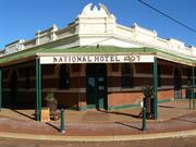
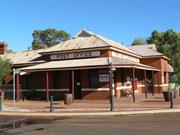
Constructed from 1907
The National Hotel has high significance as the only remaining hotel in Sandstone. The building also has high streetscape value, it being situated on a prominent corner in the town. The significance of the place is enhanced by its high authenticity and integrity. Its corner location and verandahed style if typical of Australian pub tradition. The hotel is a dominant structure in the town because of its masonry form.
Located on the corner of Oroya and Payne Street, the hotel is of brick construction with a corrugated iron roof. The building has a wrap around bullnosed verandah which extends over the footpath and a central courtyard. It features a rendered decorative parapet with rendered horizontal banding around the street facades. The building is truncated at the corner with a double entry door and a segmental pediment emphasising the main entrance. The verandah, at its truncation, bares the name and date of the hotel. The building has a number of arched windows as well as timber framed double hung windows. It features corbelled brick chimneys such as those on the Post Office (Place 3) and Warden's Court (Place 2).
The smallest of the four hotels built in Sandstone during the goldrush years, the National Hotel is also the only one still remaining. It was built by Mr W.A. Richardson in 1909 using bricks fired in a local kiln near 'Hacks'. The Black Range Courier recorded the opening of the hotel on July 5, 1907: "Mr W.A. Richardson, late of Bunbury, opened the National Hotel at Sandstone on Monday morning, most of his stock coming to hand on the previous Saturday. The hotel, which is centrally situated in Oroya Street is built of brick and is well finished. Although not large, the hotel is tastefully arranged. The rooms are well ventilated and an open court in the centre of the building ensures coolness for those patronising the hotel during hot weather." The hotel has been in The smallest of the four hotels built in Sandstone during the goldrush years, the National Hotel is also the only one still remaining. It was built by Mr W.A. Richardson in 1909 using bricks fired in a local kiln near 'Hacks'. The Black Range Courier recorded the opening of the hotel on July 5, 1907: "Mr W.A. Richardson, late of Bunbury, opened the National Hotel at Sandstone on Monday morning, most of his stock coming to hand on the previous Saturday. The hotel, which is centrally situated in Oroya Street is built of brick and is well finished. Although not large, the hotel is tastefully arranged. The rooms are well ventilated and an open court in the centre of the building ensures coolness for those patronising the hotel during hot weather." The hotel has been inThe smallest of the four hotels built in Sandstone during the goldrush years, the National Hotel is also the only one still remaining. It was built by Mr W.A. Richardson in 1909 using bricks fired in a local kiln near 'Hacks'. The Black Range Courier recorded the opening of the hotel on July 5, 1907: "Mr W.A. Richardson, late of Bunbury, opened the National Hotel at Sandstone on Monday morning, most of his stock coming to hand on the previous Saturday. The hotel, which is centrally situated in Oroya Street is built of brick and is well finished. Although not large, the hotel is tastefully arranged. The rooms are well ventilated and an open court in the centre of the building ensures coolness for those patronising the hotel during hot weather." The hotel has been in continuous use since construction and remains a popular resting place for Murchison travellers.
Integrity: High Degree
Good
| Ref ID No | Ref Name | Ref Source | Ref Date |
|---|---|---|---|
| "Sandstone Heritage Trail brochure". | |||
| "The Black Range Courier". |
| Owner | Category |
|---|---|
| BW Hewitt | Other Private |
This information is provided voluntarily as a public service. The information provided is made available in good faith and is derived from sources believed to be reliable and accurate. However, the information is provided solely on the basis that readers will be responsible for making their own assessment of the matters discussed herein and are advised to verify all relevant representations, statements and information.
Dandaraga Station Sandstone
Sandstone
Midwest
| Type | Status | Date | Documents |
|---|---|---|---|
| (no listings) |
| Type | Status | Date | Documents |
|---|---|---|---|
| (no listings) |
| Type | Status | Date | Grading/Management | |
|---|---|---|---|---|
| Category | ||||
| Municipal Inventory | Adopted | 25 Jun 1997 | Category 3 | |
09127 Dandaraga Homestead, inc Shearer's Qtrs
Individual Building or Group
| Epoch | General | Specific |
|---|---|---|
| Present Use | COMMERCIAL | Hotel, Tavern or Inn |
| Original Use | COMMERCIAL | Hotel, Tavern or Inn |
| General | Specific |
|---|---|
| OCCUPATIONS | Hospitality industry & tourism |
This information is provided voluntarily as a public service. The information provided is made available in good faith and is derived from sources believed to be reliable and accurate. However, the information is provided solely on the basis that readers will be responsible for making their own assessment of the matters discussed herein and are advised to verify all relevant representations, statements and information.
Constructed from 1900
The former Bell View has historic significance for its role as a traveller's inn and a local recreation place.
The Bell View Hotel, located in Bell Chambers Paddock on Dandaraga Station, was a travellers inn.
| Owner | Category |
|---|---|
| Crown Land | Commonwealth Gov't |
This information is provided voluntarily as a public service. The information provided is made available in good faith and is derived from sources believed to be reliable and accurate. However, the information is provided solely on the basis that readers will be responsible for making their own assessment of the matters discussed herein and are advised to verify all relevant representations, statements and information.
Dandaraga Station Sandstone
Yallawun Pool
Sandstone
Midwest
Constructed from 1900
| Type | Status | Date | Documents |
|---|---|---|---|
| (no listings) |
| Type | Status | Date | Documents |
|---|---|---|---|
| (no listings) |
| Type | Status | Date | Grading/Management | |
|---|---|---|---|---|
| Category | ||||
| Municipal Inventory | Adopted | 25 Jun 1997 | Category 3 | |
09127 Dandaraga Homestead, inc Shearer's Qtrs
Historic site
| Epoch | General | Specific |
|---|---|---|
| Present Use | SOCIAL\RECREATIONAL | Other |
| Original Use | FARMING\PASTORAL | Other |
| General | Specific |
|---|---|
| SOCIAL & CIVIC ACTIVITIES | Sport, recreation & entertainment |
| OCCUPATIONS | Grazing, pastoralism & dairying |
This information is provided voluntarily as a public service. The information provided is made available in good faith and is derived from sources believed to be reliable and accurate. However, the information is provided solely on the basis that readers will be responsible for making their own assessment of the matters discussed herein and are advised to verify all relevant representations, statements and information.
Constructed from 1900
Yallowan Pool has historic significance for its association with Dandaraga Station and the pastoral industry in the Sandstone district. It has further social significance as a favourite place for picnics for the local community.
This information is provided voluntarily as a public service. The information provided is made available in good faith and is derived from sources believed to be reliable and accurate. However, the information is provided solely on the basis that readers will be responsible for making their own assessment of the matters discussed herein and are advised to verify all relevant representations, statements and information.
8 Green St Sandstone
Sandstone
Midwest
Constructed from 1909
| Type | Status | Date | Documents |
|---|---|---|---|
| (no listings) |
| Type | Status | Date | Documents |
|---|---|---|---|
| RHP - Assessed - Deferred | Current | 22 Jul 2012 |
| Type | Status | Date | Grading/Management | |
|---|---|---|---|---|
| Category | ||||
| Municipal Inventory | Adopted | 25 Jun 1997 | Category 2 | |
02352 Sandstone Townsite Group
Individual Building or Group
| Epoch | General | Specific |
|---|---|---|
| Present Use | RESIDENTIAL | Single storey residence |
| Original Use | EDUCATIONAL | Housing or Quarters |
| Type | General | Specific |
|---|---|---|
| Wall | TIMBER | Weatherboard |
| Roof | METAL | Corrugated Iron |
| General | Specific |
|---|---|
| SOCIAL & CIVIC ACTIVITIES | Education & science |
This information is provided voluntarily as a public service. The information provided is made available in good faith and is derived from sources believed to be reliable and accurate. However, the information is provided solely on the basis that readers will be responsible for making their own assessment of the matters discussed herein and are advised to verify all relevant representations, statements and information.
Constructed from 1900
The former school teacher's house has historic significance for its association with the Sandstone School and education in the town. The house also has aesthetic significance as it is one of the largest residences of its era in the town which reflects the importance of the school teacher in the town. Its weatherboard cladding is an unusual building material for the district.
The building is of timber frame construction with weatherboards to the walls and a corrugated iron clad roof. The building has a dutch gable roof with decorative gablets. There are verandahs to all sides. The house features a large brick corbelled chimney and air vents to the roof.
The house was the school teacher's residence in previous years.
Integrity: High
Good
| Owner | Category |
|---|---|
| PJ Denny | Other Private |
This information is provided voluntarily as a public service. The information provided is made available in good faith and is derived from sources believed to be reliable and accurate. However, the information is provided solely on the basis that readers will be responsible for making their own assessment of the matters discussed herein and are advised to verify all relevant representations, statements and information.
173-5 Griffith St Sandstone
Cnr Oroya St
Sandstone Primary School
Sandstone
Midwest
Constructed from 1908
| Type | Status | Date | Documents |
|---|---|---|---|
| (no listings) |
| Type | Status | Date | Documents |
|---|---|---|---|
| (no listings) |
| Type | Status | Date | Grading/Management | |
|---|---|---|---|---|
| Category | ||||
| Municipal Inventory | Adopted | 25 Jun 1997 | Category 2 | |
02352 Sandstone Townsite Group
Individual Building or Group
| Epoch | General | Specific |
|---|---|---|
| Present Use | EDUCATIONAL | Primary School |
| Original Use | GOVERNMENTAL | Courthouse |
| Type | General | Specific |
|---|---|---|
| Wall | BRICK | Common Brick |
| Roof | METAL | Corrugated Iron |
| General | Specific |
|---|---|
| SOCIAL & CIVIC ACTIVITIES | Law & order |
This information is provided voluntarily as a public service. The information provided is made available in good faith and is derived from sources believed to be reliable and accurate. However, the information is provided solely on the basis that readers will be responsible for making their own assessment of the matters discussed herein and are advised to verify all relevant representations, statements and information.
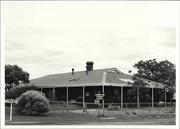
Constructed from 1908
Over the years the place has had high social significance for its association with law and order, education and health in the district. In addition the building, which is one of the largest buildings in the town, has high streetscape value as it is prominently positioned at the entrance to the town. The design of the building is evidence of its importance to the town.
The building is of double brick construction with a corrugated iron roof. It features verandahs to all sides and air vents to the roof. The roof is supported on thin metal posts and features a louvred gablet and a tall brick corbelled chimney. Windows are timber framed and double hung. The building is surrounded by an iron pole and mesh fence. The building shares characteristics with the Post Office (Place 3) and the National Hotel (Place 10) such as the brick construction, the corbelled chimneys, and the air vents.
In March 1908 E. Coombe was announced as the successful contractor to build the Warden's Court at a cost of 1,500 pounds. Built from bricks made at the local brickworks, The Black Range Courier described the building in June 1908: "Built in bungalow style, the new structure is certainly not of an imposing character and it is a pity the walls and roof were not several feet higher as the building presents a very "squat" appearance now. But it will be a vast improvement on the accommodation provided in the past, more especially the tent which did duty at Sandstone for six months." (26/6/1908, p.2) This tent structure had been removed from the Nungarra Townsite for use in Sandstone on Lot 31. The building was opened on Tuesday, 11 August, 1908 by Mr A.G. Clifton, Resident Magistrate. (The Black Range Courier, 14/8/1908, p.2) In 1923 the building was used as the State School and in the 1950s a nursing post was established there. The building was also used as the rooms for the C.W.A. which was established in 1948. At present the place remains the Sandstone Primary School and still functions as a nursing post in conjunction with the Royal Flying Doctors.
Integrity: Medium Degree
Good
| Owner | Category |
|---|---|
| Education Department | State Gov't |
This information is provided voluntarily as a public service. The information provided is made available in good faith and is derived from sources believed to be reliable and accurate. However, the information is provided solely on the basis that readers will be responsible for making their own assessment of the matters discussed herein and are advised to verify all relevant representations, statements and information.
Hack St Sandstone
Sandstone
Midwest
Constructed from 1964
| Type | Status | Date | Documents |
|---|---|---|---|
| (no listings) |
| Type | Status | Date | Documents |
|---|---|---|---|
| (no listings) |
| Type | Status | Date | Grading/Management | |
|---|---|---|---|---|
| Category | ||||
| Municipal Inventory | Adopted | 25 Jun 1997 | Category 5 | |
Individual Building or Group
| Epoch | General | Specific |
|---|---|---|
| Present Use | RELIGIOUS | Church, Cathedral or Chapel |
| Original Use | RELIGIOUS | Church, Cathedral or Chapel |
| General | Specific |
|---|---|
| SOCIAL & CIVIC ACTIVITIES | Religion |
This information is provided voluntarily as a public service. The information provided is made available in good faith and is derived from sources believed to be reliable and accurate. However, the information is provided solely on the basis that readers will be responsible for making their own assessment of the matters discussed herein and are advised to verify all relevant representations, statements and information.
Constructed from 1964
The site of the Anglican Church has some social and historic significance for its association with religion in the Sandstone district.
The Anglican Church had seen a number of moves. The original church was destroyed by a cyclone in 1947. The Hall was then used until it was burnt down, then church services were held in the school. The old Rectory was remodelled in 1964 and consecrated in 1965 by Bishop Frewer. It was a timber framed building clad with asbestos sheeting with a corrugated iron roof. In later years the church was used by Anglican's and Methodists. Due to its poor condition, the church was demolished in the late 1980s. [Local knowledge]
Site Only
| Ref ID No | Ref Name | Ref Source | Ref Date |
|---|---|---|---|
| WE Gaynor; "The History of Sandstone". |
| Owner | Category |
|---|---|
| Crown Land | UNKNOWN |
This information is provided voluntarily as a public service. The information provided is made available in good faith and is derived from sources believed to be reliable and accurate. However, the information is provided solely on the basis that readers will be responsible for making their own assessment of the matters discussed herein and are advised to verify all relevant representations, statements and information.
Hack St Sandstone
Sandstone
Midwest
Constructed from 1963
| Type | Status | Date | Documents |
|---|---|---|---|
| (no listings) |
| Type | Status | Date | Documents |
|---|---|---|---|
| (no listings) |
| Type | Status | Date | Grading/Management | |
|---|---|---|---|---|
| Category | ||||
| Municipal Inventory | Adopted | 25 Jun 1997 | Category 3 | |
Individual Building or Group
| Epoch | General | Specific |
|---|---|---|
| Original Use | GOVERNMENTAL | Town, Shire or District Hall |
| Present Use | EDUCATIONAL | Library |
| Present Use | GOVERNMENTAL | Town, Shire or District Hall |
| Other Use | EDUCATIONAL | Library |
| Type | General | Specific |
|---|---|---|
| Wall | ASBESTOS | Fibrous Cement, flat |
| Roof | METAL | Corrugated Iron |
| General | Specific |
|---|---|
| SOCIAL & CIVIC ACTIVITIES | Government & politics |
This information is provided voluntarily as a public service. The information provided is made available in good faith and is derived from sources believed to be reliable and accurate. However, the information is provided solely on the basis that readers will be responsible for making their own assessment of the matters discussed herein and are advised to verify all relevant representations, statements and information.
Constructed from 1963
The Shire Office and Hall has high social significance as both the centre for local government in Sandstone and as a community hall and library.
This large, timber framed asbestos clad building has a corrugated iron roof. It includes a hall, kitchen, office and ablution facilities to the rear. The medium pitched roof has exposed eaves and a ridge vent. The fenestration on the front facade is protected by a cantilevered roof (box awning). Either side of the central doorway is a group of three timber framed double hung sash windows. The building, which is built on the building line (ie. right up to the pavement), is painted lime and features a raised timber floor throughout.
The current Civic Centre was built in 1963 after the previous structure, which had only been recently renovated, was destroyed by fire in 1962. Most Shire records and the newly established library were also destroyed. A tender of 6,240 pounds was accepted to construct new combined offices, public hall and library and was opened by the Hon. S. Bovell, MLA, Minister for Lands, on April 20, 1963.
Integrity: High Degree
Good
| Ref ID No | Ref Name | Ref Source | Ref Date |
|---|---|---|---|
| "Sandstone Heritage Trail brochure". | Shire of Sandstone | ||
| E Gaynor;"The History of Sandstone". |
| Owner | Category |
|---|---|
| Shire of Sandstone | Local Gov't |
This information is provided voluntarily as a public service. The information provided is made available in good faith and is derived from sources believed to be reliable and accurate. However, the information is provided solely on the basis that readers will be responsible for making their own assessment of the matters discussed herein and are advised to verify all relevant representations, statements and information.
17 Hack St Sandstone
Sandstone
Midwest
Constructed from 1909
| Type | Status | Date | Documents |
|---|---|---|---|
| (no listings) |
| Type | Status | Date | Documents |
|---|---|---|---|
| RHP - Assessed - Deferred | Current | 22 Jul 2013 |
| Type | Status | Date | Grading/Management | |
|---|---|---|---|---|
| Category | ||||
| Municipal Inventory | Adopted | 25 Jun 1997 | Category 1 | |
02352 Sandstone Townsite Group
Individual Building or Group
| Epoch | General | Specific |
|---|---|---|
| Original Use | Transport\Communications | Comms: Post or Telegraph Office |
| Type | General | Specific |
|---|---|---|
| Wall | BRICK | Common Brick |
| General | Specific |
|---|---|
| SOCIAL & CIVIC ACTIVITIES | Community services & utilities |
This information is provided voluntarily as a public service. The information provided is made available in good faith and is derived from sources believed to be reliable and accurate. However, the information is provided solely on the basis that readers will be responsible for making their own assessment of the matters discussed herein and are advised to verify all relevant representations, statements and information.
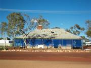
Constructed from 1908, Constructed from 1909
The Sandstone Post and Telegraph Office has high social significance for its role in increasing the level of communications in the district. The place also has high streetscape value, it being a prominent feature of the town. Further, it is a fine example of PWD buildings in the Murchison district. The design of the Post Office, enhanced by its decorative roof form and brick construction, indicates its importance in the town.
This large building, of local brick construction with a corrugated iron roof, is located on a prominent corner in the town. Addressing both streets, the building's original use is obvious with the words "Post and Telegraph Office" painted on a white background between the verandah and roof line. A verandah, attached to the wall half a metre below the main roof, wraps around the southeast corner of the Post Office. The walls have a white concrete rendered decorative band at a height of approximately lm. The timber windows are double hung and the Post Office features two timber French doors. A large, arched window has feature brickwork which enhances the shape. There is a corbelled brick chimney in the west wall of the Quarters. The windows to the Quarters have corrugated iron awnings to provide shade. The dominant roof form (dutch gable) is a feature of the building with gables and louvred vents. The verandah roof is truncated at the corner and is separate from the main roof. Two ventilation gable ends are evident in the roof line. Similarly, air vents are located around the building at ground level. An air conditioning unit attached to the roof is an intrusive element to the roof line. A brief internal inspection revealed a high level of intactness and authenticity with the original wooden floorboards and benches in place.
In 1907 Sandstone is recorded as being a "Receiver of Mailbags" which later in the year was upgraded to "Official" status. This meant that it was staffed by permanent officers of the Department. (G.E. Owen) Reserve 11128, Lot 32, was set aside for Public Buildings (Commonwealth) in January 1908. (Government Gazette, 10/1/1908, p.26) The Black Range Courier reported in October, 1908 that "the new building will consist of a commodious office, with all the usual conveniences, including private boxes; and the quarters comprise three bedrooms, dining room, kitchen, bath, store room etc., with verandah on east, north and west sides, while part of the southern side of the building will also be sheltered in the same way. The office will be enclosed with wire netting. The office walls will be 16 feet.high and those of the residential portion 12 feet." (16/10/1908, p.2) Crooks & Brooker were the successful tenderers for the Post Office building with a quote of 1,537 pounds. Government Gazette, 27/11/1908, p.3260) Built in 1908-09 from locally made bricks, the Sandstone Post and Telegraph Office opened for business in April 1909 and soon had a large staff to serve the town's growing needs. Shortly after it opened a letter carrier and telegram service was inaugurated. In 1911 a washhouse and fencing was constructed (Government Gazette, 17/2/1911, p.345), while in 1912 a substantial addition was built consisting of the north-east corner featuring the decorative window. (Government Gazette, 10/5/1912) This work was undertaken by J.A. McDonald for 365/14/8 (pounds). In 1927 records indicate that the Post Office was an "Allowance Office" meaning that it was a non-official office whereby the postmaster/mistress usually had some other employment but received renumeration from the department according to the amount of business. (G.E. Owen) In 1956 the former postmistress, Ms Atkinson, submitted an offer of 100 pounds for the Post Office property which was finally purchased by her in July 1964. (Australian Archives, File PP359/1, 1906/02: 3/4/1964) The building functioned as the Sandstone Telephone Exchange until 1985. Today it remains a licenced Post Office, General Store and Commonwealth Bank Agency.
Integrity: High Degree
Good
| Ref ID No | Ref Name | Ref Source | Ref Date |
|---|---|---|---|
| "Government Gazette". p.345 | 17/2/1911 | ||
| "Government Gazette". | 10/5/1912 | ||
| "Sandstone Heritage Trail brochure". | Shire of Sandstone | ||
| "Government Gazette,". p.26 | 3260 | 10/1/1908 | |
| "Government Gazette". p.3260 | 27/11/1908 | ||
| File PP359/1, 1906/02 | Australian Archives | 3/4/1964 | |
| "The Black Range Courier". | Oct 108 | ||
| GE Owen; "The Post, Telegraph & Telephone Offices of Western Australia: An Alphabetical List, Cottesloe", | 1958 | ||
| "Government Gazette". p.2 | 16/10/1908 |
| Owner | Category |
|---|---|
| VM Atkinson | Other Private |
This information is provided voluntarily as a public service. The information provided is made available in good faith and is derived from sources believed to be reliable and accurate. However, the information is provided solely on the basis that readers will be responsible for making their own assessment of the matters discussed herein and are advised to verify all relevant representations, statements and information.
18 Hack St Sandstone
Sandstone
Midwest
| Type | Status | Date | Documents |
|---|---|---|---|
| (no listings) |
| Type | Status | Date | Documents |
|---|---|---|---|
| RHP - Assessed - Deferred | Current | 22 Jul 2013 |
| Type | Status | Date | Grading/Management | |
|---|---|---|---|---|
| Category | ||||
| Municipal Inventory | Adopted | 25 Jun 1997 | Category 2 | |
02352 Sandstone Townsite Group
Individual Building or Group
| Epoch | General | Specific |
|---|---|---|
| Original Use | COMMERCIAL | Shop\Retail Store {single} |
| Type | General | Specific |
|---|---|---|
| Roof | METAL | Corrugated Iron |
| Wall | METAL | Corrugated Iron |
| General | Specific |
|---|---|
| OCCUPATIONS | Commercial & service industries |
This information is provided voluntarily as a public service. The information provided is made available in good faith and is derived from sources believed to be reliable and accurate. However, the information is provided solely on the basis that readers will be responsible for making their own assessment of the matters discussed herein and are advised to verify all relevant representations, statements and information.
Constructed from 1900
The corner shop has historic significance as the only remaining store in the once bustling town of Sandstone. It has fulfilled an essential role in supplying goods to local residents. In addition, the building has high streetscape value.
This timber framed building is clad with corrugated iron and features many original internal fittings such as timber shelving. A lean-to verandah roof protects the front facade (west elevation). A disused pump stands in front of the shop. A timber fridge structure is located at the rear of the shop. It is collapsing in part and shows evidence of bad white ant damage.
The shop was the General Store in Sandstone for many years. It also provided power from a generator for a number of local residents. [Local knowledge] The Sandstone Co-operative was formed on 22 June, 1975 in order to keep the General Store open. It disbanded the following month.
Integrity: High Degree
Good
| Ref ID No | Ref Name | Ref Source | Ref Date |
|---|---|---|---|
| S Senior; "From Gold to Wool and Back Again". |
| Owner | Category |
|---|---|
| JR & VM Atkinson | Other Private |
This information is provided voluntarily as a public service. The information provided is made available in good faith and is derived from sources believed to be reliable and accurate. However, the information is provided solely on the basis that readers will be responsible for making their own assessment of the matters discussed herein and are advised to verify all relevant representations, statements and information.
off Irvine St Sandstone
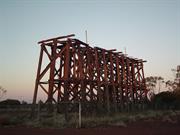
Old Railway Tank Stand (fmr)
Water Tank Stand (fmr)
Sandstone
Midwest
Constructed from 1910 to 1949
| Type | Status | Date | Documents |
|---|---|---|---|
| (no listings) |
| Type | Status | Date | Documents |
|---|---|---|---|
| RHP - Does not warrant assessment | Current | 27 Apr 2007 |
| Type | Status | Date | Grading/Management | |
|---|---|---|---|---|
| Category | ||||
| Municipal Inventory | Adopted | 25 Jun 1997 | ||
02352 Sandstone Townsite Group
Demolished
| Library Id | Title | Medium | Year Of Publication |
|---|---|---|---|
| 7577 | Shire of Sandstone tank stand : structural condition report. | Heritage Study {Other} | 2005 |
Individual Building or Group
| Epoch | General | Specific |
|---|---|---|
| Present Use | VACANT\UNUSED | Vacant\Unused |
| Original Use | GOVERNMENTAL | Other |
| General | Specific |
|---|---|
| DEMOGRAPHIC SETTLEMENT & MOBILITY | Depression & boom |
This information is provided voluntarily as a public service. The information provided is made available in good faith and is derived from sources believed to be reliable and accurate. However, the information is provided solely on the basis that readers will be responsible for making their own assessment of the matters discussed herein and are advised to verify all relevant representations, statements and information.
Constructed from 1949, Constructed from 1910
associated with the railway. The Tank Stand combined with the Goods Shed, the railway dam and sidings are the only visual evidence of the railway which figured prominently in the development of Sandstone. The size and location of the structure make it a very prominent feature of the town.
This large timber structure located at the end of Hack Street originally had four corrugated iron water tanks on top of it. Criss cross bracing reinforces the structure.
The railway was extended to Sandstone in 1910 and remained in operation until 1949. The water tanks provided water for the steam engines.
Integrity: Medium Degree Modifications: The water tanks have been removed.
Poor
| Owner | Category |
|---|---|
| Crown Land | UNKNOWN |
This information is provided voluntarily as a public service. The information provided is made available in good faith and is derived from sources believed to be reliable and accurate. However, the information is provided solely on the basis that readers will be responsible for making their own assessment of the matters discussed herein and are advised to verify all relevant representations, statements and information.