Local Government
Serpentine-Jarrahdale
Region
Peel
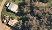
681 Hopkinson Rd Cardup
Serpentine-Jarrahdale
Peel
| Type | Status | Date | Documents |
|---|---|---|---|
| (no listings) |
| Type | Status | Date | Documents |
|---|---|---|---|
| (no listings) |
| Type | Status | Date | Grading/Management | |
|---|---|---|---|---|
| Category | ||||
| Local Heritage Survey | Adopted | 19 Sep 2022 | Category 3 | |
| Municipal Inventory | Adopted | 01 Jun 2000 | Category 4 | |
Individual Building or Group
| Epoch | General | Specific |
|---|---|---|
| Original Use | INDUSTRIAL\MANUFACTURING | Dairy, Butter or Cheese Factory |
| Type | General | Specific |
|---|---|---|
| Wall | STONE | Other Stone |
| Roof | METAL | Corrugated Iron |
| Wall | BRICK | Other Brick |
| General | Specific |
|---|---|
| OCCUPATIONS | Grazing, pastoralism & dairying |
This information is provided voluntarily as a public service. The information provided is made available in good faith and is derived from sources believed to be reliable and accurate. However, the information is provided solely on the basis that readers will be responsible for making their own assessment of the matters discussed herein and are advised to verify all relevant representations, statements and information.

Fremnells Dairy is a relatively intact example of an operational dairy farm established in the Serpentine Agricultural area and has historic value in its association with the Orton and Kargotich families.
At the front of the property is a set of modest industrial buildings comprising small stone/brick building with flat corrugated iron roof attached to a larger corrugated iron building with gable roof. A small timber building with a skillion corrugated iron roof is located to the south of the main building. A water tank on a tower is located outside the large corrugated iron building and a jarrah post and railing fence runs the length of the buildings along Hopkinson Road. A steel and mesh gate with the name "Fremnells" provides an entry statement to the dairy buildings aid the residence located at the eastern end. The property is located west of the railway.
In October 1902, John Poole of Fremantle was granted a conditional purchase lease of Serpentine Agricultural Area Lot 33 consisting of 312 acres 2 roods, for a cost of £7/16/4. Originally the land consisted of 313 acres, but this was amended in 1904 to allow for the road reserve. [CPL No. 4136/55. 1/10/1902] The property was one of several land holdings (homestead blocks) allocated in the Mundijong-Cardup sector of the Serpentine Agricultural Area at this time. In 1904, the lease was transferred to Thomas Brenehley and the following year it was again transferred to Thomas and Robert Cook. In 1911, the lease was transferred to Ethel Emily Ross of Beenup. In 1912, Ethel married Angus Clarke, a farmer also from Beenup. In 1912. the lease was transferred to A. E. Orton. a farmer of Byford, and established the property as "Fremnells". which was the name of the Orton family homestead in Essex. [Coy, p. 179] Orton more than likely constructed the buildings at this time. In 1924. Orton was granted purchase of Lot 33 for £156/5. [Grant Vol. 872 Fol. 78] The property remained in the Orton family until 1978 when it was transferred to Thomas. Stephen and Peter Kargotich. (Jack Orton - son of A. E. Orton - had married Anne Kargotich. hence the family connection.) Peter Kargotich and Jack Orton joined forces and worked on the farm together, and, in the 1950s, they had established a successful earth moving business, which became a major source of local employment. They became the first earth-moving contractors for Alcoa at Jarrahdale. [Coy. p. 221]
Fair
| Ref Number | Description |
|---|---|
| SJ2-04 | Local Heritage Survey |
| Reserve | Lot/Location | Plan/Diagram | Vol/Folio |
|---|---|---|---|
| 226005 | 872/78 |
| Owner | Category |
|---|---|
| Kargotich Brothers | Other Private |
This information is provided voluntarily as a public service. The information provided is made available in good faith and is derived from sources believed to be reliable and accurate. However, the information is provided solely on the basis that readers will be responsible for making their own assessment of the matters discussed herein and are advised to verify all relevant representations, statements and information.
354 Soldier's Rd Cardup
Serpentine-Jarrahdale
Peel
| Type | Status | Date | Documents |
|---|---|---|---|
| (no listings) |
| Type | Status | Date | Documents |
|---|---|---|---|
| (no listings) |
| Type | Status | Date | Grading/Management | |
|---|---|---|---|---|
| Category | ||||
| (no listings) | ||||
Individual Building or Group
| Epoch | General | Specific |
|---|---|---|
| Present Use | RESIDENTIAL | Single storey residence |
| Type | General | Specific |
|---|---|---|
| Roof | METAL | Corrugated Iron |
| Wall | BRICK | Rendered Brick |
This information is provided voluntarily as a public service. The information provided is made available in good faith and is derived from sources believed to be reliable and accurate. However, the information is provided solely on the basis that readers will be responsible for making their own assessment of the matters discussed herein and are advised to verify all relevant representations, statements and information.
Bruns Dr Darling Downs
Old Address: South Western Hwy, Wungong Brook, Wungong. New address brought about by sub division.
Hall Homestead/Brun's Holding
Serpentine-Jarrahdale
Peel
| Type | Status | Date | Documents |
|---|---|---|---|
| Heritage List | Adopted | 18 Sep 2020 |
| Type | Status | Date | Documents |
|---|---|---|---|
| RHP - Does not warrant assessment | Current | 28 Jan 2000 |
| Type | Status | Date | Grading/Management | |
|---|---|---|---|---|
| Category | ||||
| Local Heritage Survey | Adopted | 18 Feb 2018 | Category 1A | |
| Municipal Inventory | Adopted | 31 Jul 2000 | Category 2 | |
Good.
Individual Building or Group
| Epoch | General | Specific |
|---|---|---|
| Present Use | RESIDENTIAL | Single storey residence |
| Original Use | FARMING\PASTORAL | Cottage |
| Type | General | Specific |
|---|---|---|
| Wall | BRICK | Common Brick |
| Wall | TIMBER | Weatherboard |
| Roof | METAL | Corrugated Iron |
| General | Specific |
|---|---|
| PEOPLE | Early settlers |
| DEMOGRAPHIC SETTLEMENT & MOBILITY | Settlements |
| OCCUPATIONS | Grazing, pastoralism & dairying |
This information is provided voluntarily as a public service. The information provided is made available in good faith and is derived from sources believed to be reliable and accurate. However, the information is provided solely on the basis that readers will be responsible for making their own assessment of the matters discussed herein and are advised to verify all relevant representations, statements and information.
Constructed from 1847
The property has historic and social significance in its long association with pioneering families of the region and in its success as a dairy farm.
Four-roomed cottage situated close to the Wungong Brook with a small orchard between the Brook and the cottage. Originally part of a larger holding.
Originally owned by George and John Armstrong (who came out with Thomas Peel) and known as Woodstock. In 1847, Henry Hasting Hall purchased the property for his family, and with his sons developed a viable farm and built the original pug-walled homestead. In 1860 the Halls sold Wungong to a wealthy Perth butcher, John Liddlelow who in turn sold it to C.M. Harwood in 1864. In 1867, Samuel Richard Hammersley purchased Wungong - he already owned the adjoining land. In 1889, Hammersley was sold to David Harwood, a brewer from Perth who built a new homestead with bricks fired on the property. In 1897 Wungong again changed hands, purchased by Albert Cockram, and he proceeded to build a racecourse on the property. By the time Charles Smith became the owner in 1906, Wungong ran one of the largest dairies in the State. A bone-gristing mill near the dairy provided fertiliser for the farm. Charles Smith also built the present homestead in 1918. Wungong was then owned by H.O. Drummond, and in 1925 it was purchased by Oscar Bruns. After Oscar passed away in 1962, his son John W Bruns inherited the farm. (Wungong Brook was officially gazetted as a locality in 1980 [Government Gazette, 29/8/1980, p3040], named after Wungong Brook which flows past the south-west corner of the town.
Modifications: Extension at rear and verandah.
Good
| Ref Number | Description |
|---|---|
| SJ14-01 | Local Heritage Survey |
| 25 | Scheme List |
| Reserve | Lot/Location | Plan/Diagram | Vol/Folio |
|---|---|---|---|
| Lot 9002 | 422038 | 2524/764 |
| Owner | Category |
|---|---|
| J. Bruns | Other Private |
This information is provided voluntarily as a public service. The information provided is made available in good faith and is derived from sources believed to be reliable and accurate. However, the information is provided solely on the basis that readers will be responsible for making their own assessment of the matters discussed herein and are advised to verify all relevant representations, statements and information.
80 Bruns Drive Darling Downs
Adjacent to the Bruns Drive / Harwood Pass roundabout, backing onto the Wungong Brook
Serpentine-Jarrahdale
Peel
| Type | Status | Date | Documents |
|---|---|---|---|
| (no listings) |
| Type | Status | Date | Documents |
|---|---|---|---|
| (no listings) |
| Type | Status | Date | Grading/Management | |
|---|---|---|---|---|
| Category | ||||
| Local Heritage Survey | Adopted | 19 Sep 2022 | Category 3 | |
Historic site
| Epoch | General | Specific |
|---|---|---|
| Present Use | RESIDENTIAL | Single storey residence |
| Original Use | FARMING\PASTORAL | Homestead |
| Style |
|---|
| Inter-War California Bungalow |
| Type | General | Specific |
|---|---|---|
| Wall | BRICK | Rendered Brick |
| Roof | TILE | Terracotta Tile |
| General | Specific |
|---|---|
| OCCUPATIONS | Grazing, pastoralism & dairying |
This information is provided voluntarily as a public service. The information provided is made available in good faith and is derived from sources believed to be reliable and accurate. However, the information is provided solely on the basis that readers will be responsible for making their own assessment of the matters discussed herein and are advised to verify all relevant representations, statements and information.

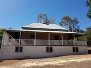
Significant in its bespoke architecture, signifying a statement that the family were doing well in their agricultural enterprise. Urban creep means the landholding no longer exists in its entirety, despite this the building itself has not changed significantly.
Single Storey home with informal lawns and gardens surrounding this substantial home. Moderate pitched terracotta tiled roof extending over wrap around verandahs with exposed rafters and purlins projecting from the roof. The roof has terracotta ridge decorative capping with terracotta gable finials. A large decorative gable with mock english tudor timber and render, spanning the entire width of the walls adorns the front elevation. Stuco rendered finish, could be a more recent addition to the brick exterior. Heavily built verandah posts with a slight 'art deco' appearance to the upper front posts. The east facing verandah has been particially inbuilt. Half Verandah is concrete painted red with steps leading down from the centre to a path. A very large Port Jackson Fig, most likely planted at build time, situated on the right hand corner of the homestead.
Built in 1918 after the first homestead of Wungong Farm burnt down in 1908. John Bruns bought the farm from his father Oscar Bruns in 1962. Subdivision from Wungong Farm Cottage occurred in c2000
| Ref Number | Description |
|---|---|
| SJ3-04 | Local Heritage Survey |
| Reserve | Lot/Location | Plan/Diagram | Vol/Folio |
|---|---|---|---|
| 612 | 41441 | 2620/391 |
This information is provided voluntarily as a public service. The information provided is made available in good faith and is derived from sources believed to be reliable and accurate. However, the information is provided solely on the basis that readers will be responsible for making their own assessment of the matters discussed herein and are advised to verify all relevant representations, statements and information.
Albany Hwy Gleneagle Via Jarrahdale
Serpentine-Jarrahdale
Peel
| Type | Status | Date | Documents |
|---|---|---|---|
| (no listings) |
| Type | Status | Date | Documents |
|---|---|---|---|
| (no listings) |
| Type | Status | Date | Grading/Management | |
|---|---|---|---|---|
| Category | ||||
| Register of the National Estate | Indicative Place | |||
Landscape
| Epoch | General | Specific |
|---|---|---|
| Original Use | PARK\RESERVE | Park\Reserve |
| General | Specific |
|---|---|
| OCCUPATIONS | Mining {incl. mineral processing} |
| OCCUPATIONS | Timber industry |
This information is provided voluntarily as a public service. The information provided is made available in good faith and is derived from sources believed to be reliable and accurate. However, the information is provided solely on the basis that readers will be responsible for making their own assessment of the matters discussed herein and are advised to verify all relevant representations, statements and information.
Jarrahdale Road Jarradahdale
Over Gooralong Brook, adjacent to Reserve 16634 (SF22)
Serpentine-Jarrahdale
Peel
| Type | Status | Date | Documents |
|---|---|---|---|
| (no listings) |
| Type | Status | Date | Documents |
|---|---|---|---|
| RHP - Does not warrant assessment | Current | 30 Aug 2019 |
| Type | Status | Date | Grading/Management | |
|---|---|---|---|---|
| Category | ||||
| (no listings) | ||||
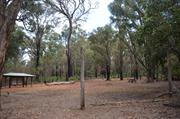
• The place demonstrates the widespread use of timber as a structural material in early twentieth century bridge building;
• The place is associated with the growth of regional infrastructure in the early twentieth century.
Bridge 4536A over Gooralong Brook, Jarrahdale Road is a single lane timber and steel road bridge spanning Gooralong Brook, and is approximately 2 km east of the town of Jarrahdale. The bridge is approximately 3.6 m long, 9.9 m wide and sits approximately 1 m above the creek bed at its highest point. The bridge is essentially a timber culvert, a single span constructed along a northeast-southwest axis. The bridge abutments consist of timber log abutment walls and timber log wing walls, further supported by metal strips driven into the ground. The foundations around the sides of the wing walls consist of random rubble masonry held together with concrete.
Noongar people living in the southwest of the continent during the pre- and early contact period can broadly be described as comprising small family groups moving through the landscape in response to seasonal change, utilising a toolkit of wooden and flaked stone tools and grinding stones, notably of quartz, dolerite and chert. The artistic culture of the Noongar people was expressed in painted and engraved art in a wide variety of forms, relating to a complex spiritual worldview that incorporated a connection to the natural world, and the remembrance or ongoing influence of ancestral and spiritual figures. In the region around Wandering, the Noongar groups were known as the Binjareb (also recorded as Pinjarup). Groups of families who may have totalled 100 people lived in the region and moved between the coast and forests. These groups utilised the natural resources of the area, coming together annually to take advantage of the cyclical abundance of various food sources. In the case of the Binjareb, the fish traps at Balgarrup were a series of communal structures that provided for such events. The families living in the jarrah forests near the Serpentine River were additionally known as the Cooralong.
Bridge in poor condition and requires replacement.
Other Built Type
| Epoch | General | Specific |
|---|---|---|
| Original Use | Transport\Communications | Road: Bridge |
| Present Use | Transport\Communications | Road: Bridge |
| Type | General | Specific |
|---|---|---|
| Other | TIMBER | Log |
| Other | METAL | Steel |
This information is provided voluntarily as a public service. The information provided is made available in good faith and is derived from sources believed to be reliable and accurate. However, the information is provided solely on the basis that readers will be responsible for making their own assessment of the matters discussed herein and are advised to verify all relevant representations, statements and information.
Jarrahdale
Includes 1949 Mill & 1968 Mill site & Company Office (1968-1997), Bunnings dump site
Serpentine-Jarrahdale
Peel
| Type | Status | Date | Documents |
|---|---|---|---|
| Heritage List | Adopted | 18 Feb 2018 |
| Type | Status | Date | Documents |
|---|---|---|---|
| RHP - To be assessed | Current | 29 Aug 2003 |
| Type | Status | Date | Grading/Management | |
|---|---|---|---|---|
| Category | ||||
| (no listings) | ||||
08488 Jarrahdale Townsite & Heritage Park
| Library Id | Title | Medium | Year Of Publication |
|---|---|---|---|
| 10269 | Mill manager's residence, Jarrahdale | Heritage Study {Cons'n Plan} | 2005 |
Precinct or Streetscape
| Epoch | General | Specific |
|---|---|---|
| Original Use | FORESTRY | Office or Administration Bldg |
| Original Use | FORESTRY | Timber Mill |
| Original Use | FORESTRY | Housing or Quarters |
This information is provided voluntarily as a public service. The information provided is made available in good faith and is derived from sources believed to be reliable and accurate. However, the information is provided solely on the basis that readers will be responsible for making their own assessment of the matters discussed herein and are advised to verify all relevant representations, statements and information.
This information is provided voluntarily as a public service. The information provided is made available in good faith and is derived from sources believed to be reliable and accurate. However, the information is provided solely on the basis that readers will be responsible for making their own assessment of the matters discussed herein and are advised to verify all relevant representations, statements and information.
Jarrahdale
Serpentine-Jarrahdale
Peel
| Type | Status | Date | Documents |
|---|---|---|---|
| (no listings) |
| Type | Status | Date | Documents |
|---|---|---|---|
| (no listings) |
| Type | Status | Date | Grading/Management | |
|---|---|---|---|---|
| Category | ||||
| (no listings) | ||||
Landscape
| Epoch | General | Specific |
|---|---|---|
| Original Use | PARK\RESERVE | Park\Reserve |
| Present Use | PARK\RESERVE | Park\Reserve |
This information is provided voluntarily as a public service. The information provided is made available in good faith and is derived from sources believed to be reliable and accurate. However, the information is provided solely on the basis that readers will be responsible for making their own assessment of the matters discussed herein and are advised to verify all relevant representations, statements and information.
Jarrahdale
Yangedi Swamp
Serpentine-Jarrahdale
Peel
| Type | Status | Date | Documents |
|---|---|---|---|
| Heritage List | Adopted | 18 Feb 2018 |
| Type | Status | Date | Documents |
|---|---|---|---|
| (no listings) |
| Type | Status | Date | Grading/Management | |
|---|---|---|---|---|
| Category | ||||
| Municipal Inventory | Adopted | 31 Jul 2000 | Category 5 | |
| Local Heritage Survey | Adopted | 19 Sep 2022 | Category 2 | |
Fair.
Landscape
| Epoch | General | Specific |
|---|---|---|
| Original Use | PARK\RESERVE | Park\Reserve |
| Present Use | PARK\RESERVE | Park\Reserve |
| General | Specific |
|---|---|
| DEMOGRAPHIC SETTLEMENT & MOBILITY | Settlements |
| TRANSPORT & COMMUNICATIONS | Droving |
This information is provided voluntarily as a public service. The information provided is made available in good faith and is derived from sources believed to be reliable and accurate. However, the information is provided solely on the basis that readers will be responsible for making their own assessment of the matters discussed herein and are advised to verify all relevant representations, statements and information.

Place of natural beauty.
Mainly paper bark and bottlebrush; hypha reed grows there - but clearing and drainage has reduced the incidence. Some regeneration going on. Swamp is a declared wetland through the Peel Inlet Management Authority. Causeway passes through the swamp- was constructed in the late 1970's.
Before the area was developed, the swamp served as a stock watering hole (mainly cattle) for stock being taken down from Serpentine-Jarrahdale to the coast because it contained fresh water. Also used for recreational purposes. Drainage was undertaken in the early 1950's. In winter, because there is water, birds come to the swamp. Dry in summer. Road verge assessed as high conservation value.
Fair
| Ref Number | Description |
|---|---|
| SJ15-03 | Local Heritage Survey |
This information is provided voluntarily as a public service. The information provided is made available in good faith and is derived from sources believed to be reliable and accurate. However, the information is provided solely on the basis that readers will be responsible for making their own assessment of the matters discussed herein and are advised to verify all relevant representations, statements and information.
Alcoa Rd Jarrahdale
5km from Jarrahdale See book 1105WA/108 HCWA library
Serpentine-Jarrahdale
Peel
Constructed from 1963
| Type | Status | Date | Documents |
|---|---|---|---|
| (no listings) |
| Type | Status | Date | Documents |
|---|---|---|---|
| (no listings) |
| Type | Status | Date | Grading/Management | |
|---|---|---|---|---|
| Category | ||||
| Classified by the National Trust | Classified {Lscpe} | 24 May 1991 | ||
| Register of the National Estate | Indicative Place | |||
| Library Id | Title | Medium | Year Of Publication |
|---|---|---|---|
| 2354 | Jarrahdale railway cutting : nomination of a geological monument for the register of the National Estate. | Book | 1991 |
Geological monument
| Epoch | General | Specific |
|---|---|---|
| Present Use | Transport\Communications | Rail: Other |
| Original Use | Transport\Communications | Rail: Other |
| General | Specific |
|---|---|
| SOCIAL & CIVIC ACTIVITIES | Education & science |
| OCCUPATIONS | Mining {incl. mineral processing} |
| DEMOGRAPHIC SETTLEMENT & MOBILITY | Exploration & surveying |
This information is provided voluntarily as a public service. The information provided is made available in good faith and is derived from sources believed to be reliable and accurate. However, the information is provided solely on the basis that readers will be responsible for making their own assessment of the matters discussed herein and are advised to verify all relevant representations, statements and information.
Atkins Rd Jarrahdale
Serpentine-Jarrahdale
Peel
Constructed from 1954, Constructed from 1887
| Type | Status | Date | Documents |
|---|---|---|---|
| (no listings) |
| Type | Status | Date | Documents |
|---|---|---|---|
| RHP - To be assessed | Current | 29 Aug 2003 |
| Type | Status | Date | Grading/Management | |
|---|---|---|---|---|
| Category | ||||
| Local Heritage Survey | Adopted | 19 Sep 2022 | Category 3 | |
| Municipal Inventory | Adopted | 31 Jul 2000 | Category 1B | |
| Classified by the National Trust | UNKNOWN | 14 Jul 1997 | ||
08488 Jarrahdale Townsite & Heritage Park
Fair.
Historic site
| Epoch | General | Specific |
|---|---|---|
| Present Use | MONUMENT\CEMETERY | Cemetery |
| Original Use | MONUMENT\CEMETERY | Cemetery |
| Type | General | Specific |
|---|---|---|
| Other | METAL | Wrought Iron |
| Other | BRICK | Common Brick |
| General | Specific |
|---|---|
| DEMOGRAPHIC SETTLEMENT & MOBILITY | Settlements |
| PEOPLE | Early settlers |
This information is provided voluntarily as a public service. The information provided is made available in good faith and is derived from sources believed to be reliable and accurate. However, the information is provided solely on the basis that readers will be responsible for making their own assessment of the matters discussed herein and are advised to verify all relevant representations, statements and information.

Constructed from 1887
Important in the social heritage of Jarrahdale, being the final resting place of members of families who contributed to the development of the town and the region. Significant for its association with the opening of the timber industry in Jarrahdale which was the basis for the development of the Jarrahdale townsite Part of the group of historic buildings in the historic Jarrahdale townsite.
Opposite a peaceful jarrah forest first explored in the 1830's (sign in the bush). Wrought iron gates attached to red brick pillars form the entrance.
Established as a local cemetery in 1872, gazetted on the 24th October 1883, and donated by Mrs Maria Batt, the widow of Joseph Batt who had owned a flour mill in the area. Jarrahdale Cemetery continues to be a public burial ground. Those buried in the cemetery include a number of representatives of the Crock, Nettleton, Lyster, Lewis, Keirnan, Parolo, Gianatti and Buckland families. The timber company was the original undertaker. No record of burials was kept by the timber company until a government audit in 1911 recognised this. The management of the cemetery then became the responsibility of the local Roads Board and it was during this time that records were lost to a white ant invasion. Various sources of information reconstructed these records as best they could. The Jarrahdale Cemetery is the last resting place for approximately four hundred and fifty-five people that socially contributed to the locality of Jarrahdale, but not all graves are marked or occupants known. There is a memorial to Keirnans (near the wooden headstones) and Nettletons. In 1954, the gates to the cemetery were erected as a memorial to Mary Isabel Watkins and George Glyn Watkins
Fair
| Ref Number | Description |
|---|---|
| SJ5-09 | Local Heritage Survey |
| Reserve | Lot/Location | Plan/Diagram | Vol/Folio |
|---|---|---|---|
| 253928 | 3145/772 | ||
| 3145/773 | |||
| 3113/659 |
This information is provided voluntarily as a public service. The information provided is made available in good faith and is derived from sources believed to be reliable and accurate. However, the information is provided solely on the basis that readers will be responsible for making their own assessment of the matters discussed herein and are advised to verify all relevant representations, statements and information.

Atkins St Jarrahdale
Serpentine-Jarrahdale
Peel
Constructed from 1897 to 1954
| Type | Status | Date | Documents |
|---|---|---|---|
| (no listings) |
| Type | Status | Date | Documents |
|---|---|---|---|
| RHP - To be assessed | Current |
| Type | Status | Date | Grading/Management | |
|---|---|---|---|---|
| Category | ||||
| Anglican Church Inventory | YES | 31 Jul 1996 | ||
| Classified by the National Trust | UNKNOWN | 14 Jul 1997 | ||
| Local Heritage Survey | Adopted | 19 Sep 2022 | Category 3 | |
| Municipal Inventory | Adopted | 31 Jul 2000 | Category 1B | |
08488 Jarrahdale Townsite & Heritage Park
Fair - Good
Individual Building or Group
| Epoch | General | Specific |
|---|---|---|
| Present Use | RELIGIOUS | Church, Cathedral or Chapel |
| Original Use | RELIGIOUS | Church, Cathedral or Chapel |
| Style |
|---|
| Federation Carpenter Gothic |
| Type | General | Specific |
|---|---|---|
| Roof | METAL | Corrugated Iron |
| Other | TIMBER | Other Timber |
| Wall | TIMBER | Weatherboard |
| General | Specific |
|---|---|
| SOCIAL & CIVIC ACTIVITIES | Religion |
This information is provided voluntarily as a public service. The information provided is made available in good faith and is derived from sources believed to be reliable and accurate. However, the information is provided solely on the basis that readers will be responsible for making their own assessment of the matters discussed herein and are advised to verify all relevant representations, statements and information.

Constructed from 1897
Individually the church has some historic and social significance as it represents the importance of places or worship for the local community. However, its relocation has diminished some of its cultural heritage value, although its present prominent location has landmark value and therefore enhances its aesthetic value. Consideration to be given in its association with the historic Jarrahdale townsite.
A single-storey three bay symmetrical timber (painted white) church building in Federation Carpenter Gothic style featuring high-pitched gable roof, porch, lancet shaped doors and windows. Church is set on the side of the hill and overlooks the township down to Gooralong Brook. Open to the road with trees on the upper side.
St Paul’s Church of England was built in 1897 by Millars Timber and Trading Co. Prior to the church being built, services were held in the Hall next to the Post Office. The church was originally located on the other side of Gooralong Brook (where Armstrong Road is now located). In 1954, the church was moved to 40 Atkins Street, Jarrahdale closer to the centre of the present townsite and consecrated. Alterations to the church after its relocation were carried out by Mr Andrew Della. These changes included the shortening of the porch and changes to the stairs, the addition of a tearoom, repainting from cream to white and the roof was painted green. After its relocation, the church was connected to electricity for the first time. On 1 December 2008, the church was moved to its present location, Lot 2 Jarrahdale Road next to the Old Post Office.
Fair-Good
| Ref Number | Description |
|---|---|
| SJ5-03 | Local Heritage Survey |
| Reserve | Lot/Location | Plan/Diagram | Vol/Folio |
|---|---|---|---|
| 2 | D47617 | 1418/903 |
| Owner | Category |
|---|---|
| Perth Diocesan Trustees | Church Property |
This information is provided voluntarily as a public service. The information provided is made available in good faith and is derived from sources believed to be reliable and accurate. However, the information is provided solely on the basis that readers will be responsible for making their own assessment of the matters discussed herein and are advised to verify all relevant representations, statements and information.
21 Atkins St Jarrahdale
Cnr Atkins & Cousens Sts, overlooks Serpentine Jarrahdale Tavern, Gooralong Brook below
Serpentine-Jarrahdale
Peel
Constructed from 1960
| Type | Status | Date | Documents |
|---|---|---|---|
| Heritage Agreement | YES | 17 Sep 2020 | HCWebsite.Listing+ListingDocument |
| Heritage List | Adopted | 18 Feb 2016 |
| Type | Status | Date | Documents |
|---|---|---|---|
| RHP - To be assessed | Current |
| Type | Status | Date | Grading/Management | |
|---|---|---|---|---|
| Category | ||||
| Catholic Church Inventory | Adopted | 01 Jul 1998 | ||
| Municipal Inventory | Adopted | 31 Jul 2000 | Category 1B | |
| Local Heritage Survey | Adopted | 18 Sep 2020 | Category 2 | |
08488 Jarrahdale Townsite & Heritage Park
Individual Building or Group
| Epoch | General | Specific |
|---|---|---|
| Present Use | RELIGIOUS | Church, Cathedral or Chapel |
| Original Use | RELIGIOUS | Church, Cathedral or Chapel |
| Type | General | Specific |
|---|---|---|
| Wall | ASBESTOS | Fibrous Cement, weatherboard |
| Roof | TILE | Other Tile |
| Wall | TIMBER | Weatherboard |
| Other | STONE | Local Stone |
| General | Specific |
|---|---|
| SOCIAL & CIVIC ACTIVITIES | Religion |
This information is provided voluntarily as a public service. The information provided is made available in good faith and is derived from sources believed to be reliable and accurate. However, the information is provided solely on the basis that readers will be responsible for making their own assessment of the matters discussed herein and are advised to verify all relevant representations, statements and information.

Constructed from 1960, Constructed from 1885
Individually the church has some historic and social significance as it represents the importance of places of worship for the local community and as a place to meet and socialise. Its setting, condition and design also give it an aesthetic significance. Consideration to be given in its association with the historic Jarrahdale townsitee.
A single-storey church building featuring a high-pitched gable main roof and porch with feature stone wall alongside front stairs and for footings, colonnettes supporting the porch roof, and double-hung sash windows. The front door is a double wooden door. The church is set amongst trees on the hillside overlooking the Serpentine-Jarrahdale Tavern; with Gooralong Brook below.
In March 1884, Reserve 660 was gazetted and vested in trust to the Roman Catholic Bishop of Perth (Government Gazette, 13/3/1884, p 129, file 4/84). In 1885, a catholic chapel was opened and blessed by Rev. Fr. J. Duff and known as St James. In the 1960's the present church was built.
Good
| Ref Number | Description |
|---|---|
| SJ5-04 | Local Heritage Survey |
| 8 | Scheme List |
| Reserve | Lot/Location | Plan/Diagram | Vol/Folio |
|---|---|---|---|
| 100 | 73603 | 1038/962 |
| Owner | Category |
|---|---|
| Roman Catholic Archbishop of Perth | Church Property |
| Private | Other Private |
This information is provided voluntarily as a public service. The information provided is made available in good faith and is derived from sources believed to be reliable and accurate. However, the information is provided solely on the basis that readers will be responsible for making their own assessment of the matters discussed herein and are advised to verify all relevant representations, statements and information.
Balmoral Rd Jarrahdale
Site of POW Camp
Serpentine-Jarrahdale
Peel
Constructed from 1939
| Type | Status | Date | Documents |
|---|---|---|---|
| Heritage List | Adopted | 18 Feb 2018 |
| Type | Status | Date | Documents |
|---|---|---|---|
| (no listings) |
| Type | Status | Date | Grading/Management | |
|---|---|---|---|---|
| Category | ||||
| Local Heritage Survey | Adopted | 19 Sep 2022 | Category 2 | |
| Municipal Inventory | Adopted | 31 Jul 2000 | Category 5 | |
Poor.
Historic Site
| Epoch | General | Specific |
|---|---|---|
| Present Use | OTHER | Other |
| Original Use | OTHER | Other |
| General | Specific |
|---|---|
| OUTSIDE INFLUENCES | World Wars & other wars |
This information is provided voluntarily as a public service. The information provided is made available in good faith and is derived from sources believed to be reliable and accurate. However, the information is provided solely on the basis that readers will be responsible for making their own assessment of the matters discussed herein and are advised to verify all relevant representations, statements and information.
Constructed from 1943
The site of the former POW camp has historic and social significance as a reminder of the Second World War and how it impinged on the townsite of Jarrahdale and the region. It is also included in the Jarrahdale Guided Walks and so has become an important tourist asset to the town.
Site only set among pine trees and marked by remnants of the camp and an entry statement of two tree trunks with a pole across the top. The former camp was alongside the 39 Mile Brook and near the old railway line.
During 1943 and 1944, Italians from North Africa were shipped to Australia and sent to POW camps, Jarrahdale being one selected. The camp was originally set up for the army at the commencement of the Second World War, then converted to a unfenced POW camp, holding up to 200 prisoners with Captain Giblett in charge. Prisoners were housed in tents and made useful by cutting firewood. The firewood was cut using hand tools, crosscut saws and axes, in teams of men. These same men would help load the trucks that came in to take the wood away. The prisoners were given a small sum of money to purchase necessities from the Jarrahdale stores. All washing was done in the creek. Once a month they had 3 days leave, Edgar came into the camp take the men to Mundijong on his truck. From Mundijong the men caught the train to Perth. Some POW interns took it upon themselves to go missing from the camp, going to the Farina’s for a meal and returning to the camp afterwards. In place are remnants of foundations of a pump house and washhouse/ablution block, drainage system and a fireplace chimney of the former mess hall.
MODIFICATIONS: Dismantled - remnants only remain
Poor
| Ref Number | Description |
|---|---|
| SJ5-17 | Local Heritage Survey |
| 34 | Scheme List |
| Owner | Category |
|---|---|
| Dept of Environment & Conservation (formerly CALM) | State Gov't |
This information is provided voluntarily as a public service. The information provided is made available in good faith and is derived from sources believed to be reliable and accurate. However, the information is provided solely on the basis that readers will be responsible for making their own assessment of the matters discussed herein and are advised to verify all relevant representations, statements and information.
Lot 29,30 Brady St Jarrahdale
Serpentine-Jarrahdale
Peel
Constructed from 1930
| Type | Status | Date | Documents |
|---|---|---|---|
| (no listings) |
| Type | Status | Date | Documents |
|---|---|---|---|
| RHP - To be assessed | Current |
| Type | Status | Date | Grading/Management | |
|---|---|---|---|---|
| Category | ||||
| (no listings) | ||||
17808 CALM Houses
Historic Site
| Epoch | General | Specific |
|---|---|---|
| Present Use | OTHER | Other |
| Original Use | OTHER | Other |
This information is provided voluntarily as a public service. The information provided is made available in good faith and is derived from sources believed to be reliable and accurate. However, the information is provided solely on the basis that readers will be responsible for making their own assessment of the matters discussed herein and are advised to verify all relevant representations, statements and information.
Brady St, Forrest Av, Jarrahdale Rd Jarrahdale
MI (2000) notes addresses as Lot 29 & 30 Brady Street, Lots 110-114 & 213 & No 3 & 19 Forrest Av, Lot 102 Jarrahdale Road, Jarrahdale
Serpentine-Jarrahdale
Peel
| Type | Status | Date | Documents |
|---|---|---|---|
| (no listings) |
| Type | Status | Date | Documents |
|---|---|---|---|
| RHP - To be assessed | Current |
| Type | Status | Date | Grading/Management | |
|---|---|---|---|---|
| Category | ||||
| Local Heritage Survey | Adopted | 19 Sep 2022 | Category 3 | |
| Municipal Inventory | Adopted | 31 Jul 2000 | Category 1B | |
| Classified by the National Trust | UNKNOWN | 14 Jul 1997 | ||
08488 Jarrahdale Townsite & Heritage Park
Good.
Individual Building or Group
| Epoch | General | Specific |
|---|---|---|
| Present Use | RESIDENTIAL | Single storey residence |
| Original Use | RESIDENTIAL | Single storey residence |
| Type | General | Specific |
|---|---|---|
| Wall | TIMBER | Weatherboard |
| Roof | METAL | Corrugated Iron |
| General | Specific |
|---|---|
| OCCUPATIONS | Timber industry |
This information is provided voluntarily as a public service. The information provided is made available in good faith and is derived from sources believed to be reliable and accurate. However, the information is provided solely on the basis that readers will be responsible for making their own assessment of the matters discussed herein and are advised to verify all relevant representations, statements and information.

Significant because the cottages are typical of the worker's cottages provided for the people who worked in the timber industry. Significant for their association with the opening of the timber industry in Jarrahdale which was the basis for the development of the Jarrahdale townsite Part of the group of historic buildings in the historic Jarrahdale townsite.
Seven small weatherboard, asbestos and corrugated iron cottages painted various colours, gable roofs, front verandas and most with picket fencing.
Refer National Trust Historic Places Assessment Form - Jarrahdale Townsite.
MODIFICATIONS: Some extensions to some of the cottages. 3 & 19 Forest Avenue demolished.
| Ref Number | Description |
|---|---|
| SJ5-13 | Local Heritage Survey |
This information is provided voluntarily as a public service. The information provided is made available in good faith and is derived from sources believed to be reliable and accurate. However, the information is provided solely on the basis that readers will be responsible for making their own assessment of the matters discussed herein and are advised to verify all relevant representations, statements and information.
Chestnut Rd Jarrahdale
Batts or Gooralong Mill
Serpentine-Jarrahdale
Peel
Constructed from 1855
| Type | Status | Date | Documents |
|---|---|---|---|
| Heritage List | Adopted | 18 Feb 2018 |
| Type | Status | Date | Documents |
|---|---|---|---|
| (no listings) |
| Type | Status | Date | Grading/Management | |
|---|---|---|---|---|
| Category | ||||
| Local Heritage Survey | Adopted | 19 Sep 2022 | Category 2 | |
| Municipal Inventory | Adopted | 31 Jul 2000 | Category 5 | |
Historic Site
| Epoch | General | Specific |
|---|---|---|
| Other Use | RESIDENTIAL | Two storey residence |
| Original Use | INDUSTRIAL\MANUFACTURING | Flour Mill |
| Present Use | PARK\RESERVE | Park\Reserve |
| Type | General | Specific |
|---|---|---|
| Other | TIMBER | Other Timber |
| General | Specific |
|---|---|
| OCCUPATIONS | Commercial & service industries |
This information is provided voluntarily as a public service. The information provided is made available in good faith and is derived from sources believed to be reliable and accurate. However, the information is provided solely on the basis that readers will be responsible for making their own assessment of the matters discussed herein and are advised to verify all relevant representations, statements and information.

Constructed from 1855
The former flour mill was the largest flour mill established in Serpentine-Jarrahdale and one of the earliest industries outside farming and timber.
A two-storey building (5mx4m with a wooden water wheel. Straddling Gooralong Brook to the west of Jarrahdale and Chestnut Roads). (site only)
In 1855, Gooralong was surveyed and a 4 hectare block along the Gooralong stream was chosen by John Giblett for Joseph Batt to build Serpentine-Jarrahdale’s largest flour mill. The mill (known as Batt’s Mill or Gooralong Mill) was water-powered overshot waterwheel, as was the other flour mill built alongside the Carralong stream. Traffic in and out of the flour mill moved along a series of cart tracks until roads were established with the development of the timber industry. Some of these cart tracks are still visible. In 1896, David Gaffin, Local miller who became a highly respected member of the Jarrahdale community, bought Gooralong and owned this until his disappearance in June 1926. Despite an extensive search, David was never found. The property was sold on to Thomas Tracy who described the property as the main building being 2 storey, with a wooden water-wheel. The water was conveyed from a dam, 200 metres upstream, along a gravelly trench pugged with clay and one section over a depression on the ground was the form of the thirty metre flume made from 6 x 1 jarrah planks. Water was gravity fed from the dam along the clay and wooden flume where it was directed to feed into the top of the waterwheel seated in an earthen channel created abutting the Gooralong Brook. In the 1980s, Gooralong Park became a popular camping and picnic reserve with ablutions and a pinus radiata plantation. Closed in the 1990s.
Demolished
| Ref Number | Description |
|---|---|
| 14 | Scheme List |
| SJ5-16 | Local Heritage Survey |
This information is provided voluntarily as a public service. The information provided is made available in good faith and is derived from sources believed to be reliable and accurate. However, the information is provided solely on the basis that readers will be responsible for making their own assessment of the matters discussed herein and are advised to verify all relevant representations, statements and information.
Chestnut Rd Jarrahdale
Serpentine-Jarrahdale
Peel
Constructed from 1863
| Type | Status | Date | Documents |
|---|---|---|---|
| Heritage List | Adopted | 18 Feb 2016 |
| Type | Status | Date | Documents |
|---|---|---|---|
| (no listings) |
| Type | Status | Date | Grading/Management | |
|---|---|---|---|---|
| Category | ||||
| Local Heritage Survey | Adopted | 19 Sep 2022 | Category 2 | |
| Municipal Inventory | Adopted | 31 Jul 2000 | Category 5 | |
Historic Site
| Epoch | General | Specific |
|---|---|---|
| Present Use | OTHER | Other |
| Original Use | FARMING\PASTORAL | Cottage |
| General | Specific |
|---|---|
| OCCUPATIONS | Commercial & service industries |
| DEMOGRAPHIC SETTLEMENT & MOBILITY | Settlements |
This information is provided voluntarily as a public service. The information provided is made available in good faith and is derived from sources believed to be reliable and accurate. However, the information is provided solely on the basis that readers will be responsible for making their own assessment of the matters discussed herein and are advised to verify all relevant representations, statements and information.

Constructed from 1863
The Chestnuts had historic significance in its association with Joseph Batt and because of its importance as an orchard, The remaining chestnut trees are an important marker to this site.
An early three-roomed, pug-walled cottage. Cottage demolished but chestnut trees remain.
The Chestnuts is associated with Joseph Batt (1799-1884) who married Ruth Downton, and moved to the Serpentine-Jarrahdale region in the late 1850's. Batt was a very enterprising person who was at the same time a publican, flour miller and developer. Were at the Chestnuts by mid-1863. In 1897, The Chestnuts was purchased by George Watkin and Charles Norrie and became recognised as one of the best orchards in the state, and one of the showplaces in the district, growing to 200ha. The chestnut trees mark the site if the cottage which was demolished in the 1970's.
| Ref Number | Description |
|---|---|
| SJ5-15 | Local Heritage Survey |
| 10 | Scheme List |
| Reserve | Lot/Location | Plan/Diagram | Vol/Folio |
|---|---|---|---|
| 226078 | 2138/706 |
This information is provided voluntarily as a public service. The information provided is made available in good faith and is derived from sources believed to be reliable and accurate. However, the information is provided solely on the basis that readers will be responsible for making their own assessment of the matters discussed herein and are advised to verify all relevant representations, statements and information.
Forrest Av Jarrahdale
Serpentine-Jarrahdale
Peel
| Type | Status | Date | Documents |
|---|---|---|---|
| (no listings) |
| Type | Status | Date | Documents |
|---|---|---|---|
| RHP - To be assessed | Current |
| Type | Status | Date | Grading/Management | |
|---|---|---|---|---|
| Category | ||||
| (no listings) | ||||
17808 CALM Houses
Individual Building or Group
| Epoch | General | Specific |
|---|---|---|
| Original Use | OTHER | Other |
| Present Use | OTHER | Other |
This information is provided voluntarily as a public service. The information provided is made available in good faith and is derived from sources believed to be reliable and accurate. However, the information is provided solely on the basis that readers will be responsible for making their own assessment of the matters discussed herein and are advised to verify all relevant representations, statements and information.
1 Foster Way Jarrahdale
Also part of P8488 Jarrahdale Townsite & Heritage Park
Serpentine-Jarrahdale
Peel
Constructed from 1871 to 1902
| Type | Status | Date | Documents |
|---|---|---|---|
| Heritage List | Adopted | 18 Sep 2020 | |
| State Register | Registered | 14 May 1999 | HCWebsite.Listing+ListingDocument, HCWebsite.Listing+ListingDocument |
| Type | Status | Date | Documents |
|---|---|---|---|
| (no listings) |
| Type | Status | Date | Grading/Management | |
|---|---|---|---|---|
| Category | ||||
| Local Heritage Survey | Adopted | 18 Sep 2020 | Category 1A | |
| Municipal Inventory | Adopted | 31 Jul 2000 | Category 1A | |
17287 Jarrahdale Heritage Park
| Library Id | Title | Medium | Year Of Publication |
|---|---|---|---|
| 5307 | Jarrahdale Heritage Park : Conservation Plan : January 2002 : Serpentine-Jarrahdale. | Heritage Study {Cons'n Plan} | 2002 |
| 10269 | Mill manager's residence, Jarrahdale | Heritage Study {Cons'n Plan} | 2005 |
Individual Building or Group
| Epoch | General | Specific |
|---|---|---|
| Present Use | FORESTRY | Housing or Quarters |
| Original Use | FORESTRY | Housing or Quarters |
| Style |
|---|
| Victorian Georgian |
| Vernacular |
| Type | General | Specific |
|---|---|---|
| Wall | TIMBER | Weatherboard |
| Roof | METAL | Corrugated Iron |
| General | Specific |
|---|---|
| OCCUPATIONS | Timber industry |
This information is provided voluntarily as a public service. The information provided is made available in good faith and is derived from sources believed to be reliable and accurate. However, the information is provided solely on the basis that readers will be responsible for making their own assessment of the matters discussed herein and are advised to verify all relevant representations, statements and information.
Constructed from 1889
Significant for its association with the opening of the timber industry in Jarrahdale, which was the basis for the development of the Jarrahdale townsite, and for association with Neil McNeil. The Mill Manager was also often an integral member of the community, both to workers at the mill and the local residence. Part of the group of historic buildings in the historic townsite of Jarrahdale.
Large single-storey bungalow style residence with hipped roof and spreading verandah, set low in the valley overlooking the Gooralong Brook to the north and west of the milling site.
Built c1889 to house the Mill Manager around the time of Neil McNeil's association with the mill, which began in 1889. Neil McNeil, originally from Victoria, was a prominent business man who contributed significantly to the development of the timber industry in Western Australia and was convinced that timber was the ideal building product. The Mill Manager's Residence would have been built to meet the demands and growth associated with the timber mill at the time when it was developing in the most successful timber mill in the state. Although this house was the second mill manager's house built in Jarrahdale, the first house, located further up the valley, is no longer extant.
Fair
| Ref Number | Description |
|---|---|
| SJ5-10 | Local Heritage Survey |
| 38 | Scheme List |
| Reserve | Lot/Location | Plan/Diagram | Vol/Folio |
|---|---|---|---|
| P23407 | 2169/505 |
| Owner | Category |
|---|---|
| Bunnings-Wesfarmers | Other Private |
| National Trust of Australia (WA Branch) | Inc. Non-profit body |
This information is provided voluntarily as a public service. The information provided is made available in good faith and is derived from sources believed to be reliable and accurate. However, the information is provided solely on the basis that readers will be responsible for making their own assessment of the matters discussed herein and are advised to verify all relevant representations, statements and information.