Local Government
Perth
Region
Metropolitan
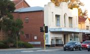
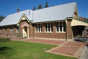
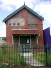
6-8 Broadway Crawley
Perth
Metropolitan
Constructed from 1935
| Type | Status | Date | Documents |
|---|---|---|---|
| State Register | Registered | 17 Oct 2003 | HCWebsite.Listing+ListingDocument, HCWebsite.Listing+ListingDocument |
| Type | Status | Date | Documents |
|---|---|---|---|
| (no listings) |
| Type | Status | Date | Grading/Management | |
|---|---|---|---|---|
| Category | ||||
| Art Deco Significant Bldg Survey | Completed | 30 Jun 1994 | ||
| Classified by the National Trust | Classified | 16 Aug 1999 | ||
| Name | Type | Year From | Year To |
|---|---|---|---|
| W G Bennett | Architect | - | - |
| Library Id | Title | Medium | Year Of Publication |
|---|---|---|---|
| 6090 | Nedlands Park Masonic Hall Broadway, Nedlands, Western Australia : heritage assessment. | Heritage Study {Other} | 2002 |
Individual Building or Group
| Epoch | General | Specific |
|---|---|---|
| Present Use | SOCIAL\RECREATIONAL | Masonic Hall |
| Present Use | COMMERCIAL | Restaurant |
| Original Use | SOCIAL\RECREATIONAL | Masonic Hall |
| Present Use | SOCIAL\RECREATIONAL | Other Community Hall\Centre |
| Present Use | COMMERCIAL | Shop\Retail Store {single} |
| Style |
|---|
| Inter-War Art Deco |
| Type | General | Specific |
|---|---|---|
| Wall | BRICK | Rendered Brick |
| Roof | METAL | Corrugated Iron |
| Roof | TILE | Terracotta Tile |
| General | Specific |
|---|---|
| SOCIAL & CIVIC ACTIVITIES | Institutions |
| SOCIAL & CIVIC ACTIVITIES | Community services & utilities |
This information is provided voluntarily as a public service. The information provided is made available in good faith and is derived from sources believed to be reliable and accurate. However, the information is provided solely on the basis that readers will be responsible for making their own assessment of the matters discussed herein and are advised to verify all relevant representations, statements and information.
This information is provided voluntarily as a public service. The information provided is made available in good faith and is derived from sources believed to be reliable and accurate. However, the information is provided solely on the basis that readers will be responsible for making their own assessment of the matters discussed herein and are advised to verify all relevant representations, statements and information.
off Mounts Bay Rd Crawley
The main historic portion of the UWA campus is in the City of Subiaco. The Park Avenue buildings to the north east are in the City of Perth.
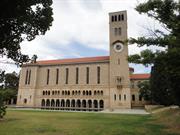
Hacket Hall & Admin Bldg & Whitfield Court
Winthrop Hall & Great Gateway, Sunken Gdn
Perth
Metropolitan
Constructed from 1930 to 1932
| Type | Status | Date | Documents |
|---|---|---|---|
| Heritage List | Adopted | 09 Jan 2004 | |
| State Register | Registered | 04 Apr 1996 | HCWebsite.Listing+ListingDocument, HCWebsite.Listing+ListingDocument |
| Type | Status | Date | Documents |
|---|---|---|---|
| (no listings) |
| Type | Status | Date | Grading/Management | |
|---|---|---|---|---|
| Category | ||||
| Art Deco Significant Bldg Survey | Completed | |||
| Survey of 20th Ctry Architecture | Completed | 01 Mar 1988 | ||
| Perth Draft Inventory 99-01 | YES | 31 Dec 1999 | ||
| Register of the National Estate | Permanent | 26 Oct 1999 | ||
| Local Heritage Survey | Adopted | 28 Mar 2023 | ||
| Local Heritage Survey | Completed\Draft | |||
| Municipal Inventory | Adopted | 13 Mar 2001 | Category 1 | |
13702 University of Western Australia-Crawley Campus
| Name | Type | Year From | Year To |
|---|---|---|---|
| Robert McK. Campbell. | Architect | - | - |
| Library Id | Title | Medium | Year Of Publication |
|---|---|---|---|
| 7781 | Appendix 2: 1. architectural competition for Winthrop Hall and other buildings - adjudicator's report 2. Design no. 141 - report 3. Design no. 137 - report. | Other | 0 |
| 4906 | The University of Western Australia : Winthrop Hall : draft interim conservation plan. | Heritage Study {Cons'n Plan} | 1999 |
| 7780 | Appendix 1: architectural competition for Winthrop hall and other buildings for the University of Western Australia - conditions regulating submission of designs, 1926. | Other | 0 |
| 6379 | High hopes. | Book | 2003 |
Individual Building or Group
| Epoch | General | Specific |
|---|---|---|
| Original Use | EDUCATIONAL | Tertiary Institution |
| Present Use | EDUCATIONAL | Tertiary Institution |
| Type | General | Specific |
|---|---|---|
| Other | STONE | Donnybrook Sandstone |
| Roof | TILE | Other Tile |
| Wall | STONE | Limestone |
| Wall | BRICK | Common Brick |
| Other | CONCRETE | Concrete Slab |
| General | Specific |
|---|---|
| SOCIAL & CIVIC ACTIVITIES | Education & science |
This information is provided voluntarily as a public service. The information provided is made available in good faith and is derived from sources believed to be reliable and accurate. However, the information is provided solely on the basis that readers will be responsible for making their own assessment of the matters discussed herein and are advised to verify all relevant representations, statements and information.
Hackett Memorial Buildings, comprising Administration Building, Hackett Hall, and Winthrop Hall, a group of composite limestone and brick structures with tiled roof and colonnade details in donnybrook stone, including the Tower and the Great Gateway, and enclosing Whitfeld Court, have cultural significance for the following reasons: the individual buildings are planned as an integrated piece of civic design which set the standard for the rest of the campus; the design of the buildings had a profound influence on Western Australian architecture in the 1930s; the place has a long association with tertiary education in Western Australia, and close association with prominent figures in the development of the institution; and, the place is held in high esteem by the University and the wider community. Winthrop Hall continues to play the traditional role as the ceremonial hall and, with the Tower, remains the focal point and symbol of the University. The Sunken Garden (1930+), although not part of the original design of the place, is historically linked to its construction. It has significance as part of the University grounds. The Bookshop (1962) has moderate significance as a building designed by Marshall Clifton to blend with Hackett Memorial Buildings. However, in the contribution it makes to the north-east continuation and definition of Whitfeld Court, it has a high degree of significance. While the Additional Buildings (1970s) contribute to the physical definition of the edges of the place, they are assessed as having low significance at this time. Listed on the State Register of Heritage Places or recommended for consideration for entry onto the State Register. Essential to the heritage of the City of Subiaco. High level of cultural heritage significance. Rare or outstanding example.
Hackett Hall is a single storey building enclosing Whitfield Court on the east and is linked by archways to Winthrop Hall. Winthrop Hall is on a central axis of the group and uses materials but on a monumental scale to dominate the composition. The tower is a landmark on the campus and is seen from Stirling Highway. The walls are a composite construction of limestone facing over brick. The base of the walls consist of sawn ashlar stone with channelled joints. The tops are rusticated and picked and laid in square, course and specked rubble.
Hackett Hall was designed for the use of the student body. It was conceived as a two-storey building to balance the composition around the central court but the ground floor was built and completed in 1931. The original accommodation comprised a billiard room, games room and men's common room in the south-west wing adjoining Winthrop Hall. The central wing, behind the arcading, contained to the south: a shop; Principal and secretary's offices; boardroom; women's reading and writing rooms; and, to the north, the women's common room, locker room and lavatories. To the north, the dining rooms were divided in two by accordion doors, with duplicate men's and women's cafeteria and general servery and kitchen backing them up. Further north, there was a kitchen yard, stores room and staff cloak rooms. In 1946, minor alterations to the kitchen and servery were carried out and in 1961, a new wing designed by Marshall Clifton was erected to the east to create a central courtyard. The 1961/62 extensions are easily identifiable and respect the building line and colour and texture. Until the mid 1970s the arrangement of the original rooms was substantially intact, with similar uses but, since this time, a number of changes have been made to meet the changing requirements of the Student Guild.16 Hackett Hall is still used by the student body, and the dining room is still in use, although no longer segregated. Part of the UWA Conservation Area SHO Place Number 24364. To be further investigated as a possible Heritage Area
High level of integrity. High level of authenticity.
Good
This information is provided voluntarily as a public service. The information provided is made available in good faith and is derived from sources believed to be reliable and accurate. However, the information is provided solely on the basis that readers will be responsible for making their own assessment of the matters discussed herein and are advised to verify all relevant representations, statements and information.
University of WA, Hackett Dve Crawley
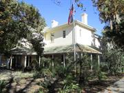
Crawley House
Perth
Metropolitan
Constructed from 1846 to 1999
| Type | Status | Date | Documents |
|---|---|---|---|
| State Register | Registered | 30 Oct 1998 | HCWebsite.Listing+ListingDocument, HCWebsite.Listing+ListingDocument |
| Type | Status | Date | Documents |
|---|---|---|---|
| (no listings) |
| Type | Status | Date | Grading/Management | |
|---|---|---|---|---|
| Category | ||||
| Local Heritage Survey | Adopted | 28 Mar 2023 | ||
| Local Heritage Survey | Completed\Draft | |||
| Classified by the National Trust | Recorded | 13 Aug 1973 | ||
| Register of the National Estate | Indicative Place | |||
13702 University of Western Australia-Crawley Campus
| Library Id | Title | Medium | Year Of Publication |
|---|---|---|---|
| 2566 | Shenton House Crawley : revised draft. | Heritage Study {Cons'n Plan} | 1997 |
Individual Building or Group
| Epoch | General | Specific |
|---|---|---|
| Original Use | FARMING\PASTORAL | Homestead |
| Present Use | EDUCATIONAL | Tertiary Institution |
| Style |
|---|
| Victorian Georgian |
| Other Style |
| Type | General | Specific |
|---|---|---|
| Wall | BRICK | Rendered Brick |
| General | Specific |
|---|---|
| SOCIAL & CIVIC ACTIVITIES | Education & science |
This information is provided voluntarily as a public service. The information provided is made available in good faith and is derived from sources believed to be reliable and accurate. However, the information is provided solely on the basis that readers will be responsible for making their own assessment of the matters discussed herein and are advised to verify all relevant representations, statements and information.
This information is provided voluntarily as a public service. The information provided is made available in good faith and is derived from sources believed to be reliable and accurate. However, the information is provided solely on the basis that readers will be responsible for making their own assessment of the matters discussed herein and are advised to verify all relevant representations, statements and information.
Mounts Bay Rd Crawley, Nedlands
Also included within P13702 University of Western Australia
Subiaco
Metropolitan
| Type | Status | Date | Documents |
|---|---|---|---|
| (no listings) |
| Type | Status | Date | Documents |
|---|---|---|---|
| (no listings) |
| Type | Status | Date | Grading/Management | |
|---|---|---|---|---|
| Category | ||||
| Register of the National Estate | Registered | 21 Oct 1980 | ||
03519 Hackett Memorial Buildings (University of Western Australia, UWA)
Landscape
| Epoch | General | Specific |
|---|---|---|
| Original Use | PARK\RESERVE | Park\Reserve |
| Present Use | PARK\RESERVE | Park\Reserve |
This information is provided voluntarily as a public service. The information provided is made available in good faith and is derived from sources believed to be reliable and accurate. However, the information is provided solely on the basis that readers will be responsible for making their own assessment of the matters discussed herein and are advised to verify all relevant representations, statements and information.
East & West Perth, Highgate, Northbridge
Perth
Metropolitan
| Type | Status | Date | Documents |
|---|---|---|---|
| State Register | Registered | 11 Sep 2015 | HCWebsite.Listing+ListingDocument, HCWebsite.Listing+ListingDocument |
| Type | Status | Date | Documents |
|---|---|---|---|
| (no listings) |
| Type | Status | Date | Grading/Management | |
|---|---|---|---|---|
| Category | ||||
| (no listings) | ||||
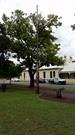
Metropolitan Sewerage Vents comprises six circular metal ventilation shafts approximately 30-50 feet (9-15 metres) high, with decorative cast iron bases providing rare evidence of the earliest establishment of deep sewerage system in Perth from 1911. The group is a smallrepresentative sample of the 1911 sewerage ventilation shafts, which have now largely been removed across the city and country.
A discontinuous group of Metropolitan Sewerage Vents. Each vent is similar in design, comprising an ornate circular cast iron base with fluting and moulding which contains the letters M S (Metropolitan Sewerage) in the lower portion. An access panel, measuring approximately 20cm by 10cm and secured by a bolt in each corner, provides visual access into the vents.
The collective group of Metropolitan Sewerage Vents were erected between c.1911 and 1928 to assist in reducing odours associated with the completion of Perth's new sewerage system. In 2013, Metropolitan Sewerage Vents remains as a collection of street furniture with no current functional use.
Historic site
| Epoch | General | Specific |
|---|---|---|
| Original Use | HEALTH | Other |
| Original Use | GOVERNMENTAL | Other |
| Type | General | Specific |
|---|---|---|
| Other | METAL | Cast Iron |
| General | Specific |
|---|---|
| SOCIAL & CIVIC ACTIVITIES | Community services & utilities |
| DEMOGRAPHIC SETTLEMENT & MOBILITY | Government policy |
| OUTSIDE INFLUENCES | Water, power, major t'port routes |
| DEMOGRAPHIC SETTLEMENT & MOBILITY | Technology & technological change |
This information is provided voluntarily as a public service. The information provided is made available in good faith and is derived from sources believed to be reliable and accurate. However, the information is provided solely on the basis that readers will be responsible for making their own assessment of the matters discussed herein and are advised to verify all relevant representations, statements and information.
Gray St Shenton Park
Located outside No 7 Gray Street
Subiaco
Metropolitan
| Type | Status | Date | Documents |
|---|---|---|---|
| (no listings) |
| Type | Status | Date | Documents |
|---|---|---|---|
| (no listings) |
| Type | Status | Date | Grading/Management | |
|---|---|---|---|---|
| Category | ||||
| (no listings) | ||||
23992 Metropolitan Sewerage Vents
Other Built Type
| Epoch | General | Specific |
|---|---|---|
| Original Use | GOVERNMENTAL | Other |
| Type | General | Specific |
|---|---|---|
| Other | METAL | Cast Iron |
| General | Specific |
|---|---|
| SOCIAL & CIVIC ACTIVITIES | Community services & utilities |
| DEMOGRAPHIC SETTLEMENT & MOBILITY | Settlements |
This information is provided voluntarily as a public service. The information provided is made available in good faith and is derived from sources believed to be reliable and accurate. However, the information is provided solely on the basis that readers will be responsible for making their own assessment of the matters discussed herein and are advised to verify all relevant representations, statements and information.
271 Bagot Rd Subiaco
Infants State, Senior School
Subiaco Public School, State School
Subiaco
Metropolitan
Constructed from 1897 to 1998
| Type | Status | Date | Documents |
|---|---|---|---|
| Heritage List | Adopted | 22 May 2012 | |
| State Register | Registered | 28 Aug 2001 | HCWebsite.Listing+ListingDocument, HCWebsite.Listing+ListingDocument |
| Type | Status | Date | Documents |
|---|---|---|---|
| (no listings) |
| Type | Status | Date | Grading/Management | |
|---|---|---|---|---|
| Category | ||||
| Municipal Inventory | Adopted | 24 Sep 2002 | Exceptional Significance (Level 1) | |
| Register of the National Estate | Permanent | 28 Sep 1982 | ||
| Classified by the National Trust | Classified | 01 Dec 1980 | ||
24360 Civic and Cultural Centre Conservation Area
| Name | Type | Year From | Year To |
|---|---|---|---|
| Hilson Beasley | Architect | - | - |
| George Temple Poole | Architect | - | - |
| Library Id | Title | Medium | Year Of Publication |
|---|---|---|---|
| 9930 | Subiaco Primary School Subiaco, Perth. Watching brief and archaeological test excavation. | Heritage Study {Other} | 2012 |
| 9139 | Mapping schools: exploring spatial histories of government primary schools in Western Australia. | Book | 2004 |
| 3368 | Subiaco Primary School Conservation Plan | Heritage Study {Cons'n Plan} | 1997 |
Individual Building or Group
| Epoch | General | Specific |
|---|---|---|
| Original Use | EDUCATIONAL | Primary School |
| Original Use | EDUCATIONAL | Combined School |
| Present Use | EDUCATIONAL | Primary School |
| Style |
|---|
| Federation Free Style |
| Federation Arts and Crafts |
| Type | General | Specific |
|---|---|---|
| Roof | METAL | Corrugated Iron |
| Wall | BRICK | Common Brick |
| General | Specific |
|---|---|
| SOCIAL & CIVIC ACTIVITIES | Institutions |
| SOCIAL & CIVIC ACTIVITIES | Community services & utilities |
| SOCIAL & CIVIC ACTIVITIES | Education & science |
This information is provided voluntarily as a public service. The information provided is made available in good faith and is derived from sources believed to be reliable and accurate. However, the information is provided solely on the basis that readers will be responsible for making their own assessment of the matters discussed herein and are advised to verify all relevant representations, statements and information.
Constructed from 1897
Refer to HCWA's Assessment Documentation of Places for Entry in the Register of Heritage Places.
Brick and corrugated iron building. Decorative name over the main entrance, and turned timber eaves struts. For more detail refer to HCWA's Assessment Documentation of Places for Entry in the Register of Heritage Places. (Ref: HCWA & AHC assessment documentation.)
Built as part of the expansion of community facilities which accompanied the gold boom of the 1890s. The plan form, including central assembly hall, is a reflection of the prevailing education methods of the time. Design attributed to George Temple Poole, PWD Chief Architect. Opened 12 May 1897, with an enrolment of 390 children. A month later a fire gutted the new building. It was rebuilt and additions were carried out soon after and again in 1912. For more detail refer to HCWA's Assessment Documentation of Places for Entry in the Register of Heritage Places. (Ref: HCWA & AHC assessment documentation.) George Temple Poole was Chief Architect of the Department of Works and Buildings (later Public Works Department and now Contract and Management Services) between 1885 and 1897. Temple Poole was born 29th May 1856, and grew up in England. He studied architecture and engineering, and worked in England and Ceylon before the Secretary for the Colonies appointed him Superintendent of Public Works of the Imperial Service in Western Australia. In the first years of office, Temple Poole travelled around the state to inspect the colony's works, labour resources and building materials. The overland telegraph had been built in 1875, and the first railway line in Perth by 1881, connecting to major country towns by 1885. Therefore some of the first works Temple Poole oversaw were post offices, railway stations and associated residences. The discovery of gold in 1885 led to gold rushes in the 1890s in WA, and Temple Poole oversaw the construction of many public buildings built to accommodate the growing population. His works extend from Roebourne to Albany. In 1897, Temple Poole resigned from the public service. He returned to the PWD in 1900 as architect for the quarters of the Goldfields Water Supply Scheme until 1902, when C Y O'Connor died. Later Poole was a public lecturer, and also returned to private practice. He retired in 1930. He died in 1934, aged seventy seven. In his lifetime, Poole was a Justice of the Peace, a founding member and first President of the WA Institute of Architects, and a member of the WA Society of Arts, Civil Service Association, the Weld Club, the Kings Park Board and the Freemasons. (Ref: Oldham, Ray and John, 'George Temple-Poole: Architect of the Golden Years 1885-1897,' Western Heritage Part 2, UWA Press, 1980; and Dr. Van Bremen, Ingrid, H., 'The New Architecture of the Gold Boom in Western Australia Government Buildings Under the Direction of G. T. Poole, 1885-1897,' Ph. D. Theses, UWA,1990.) The civic square is in the heart of Subiaco, bounded by Rokeby, Hamersley, Hensman and Bagot Roads. The eastern portion of the civic square has been used for civic purposes since 1899 when the first council chambers was built next to the original post office and library on the corner of Bagot and Rokeby Roads. It also housed the Literary Institute. Sir John Forrest opened the Council Chambers on 3.11.1900. The space was soon inadequate and a foundation stone was laid in 1909 for a larger chambers and hall next to it. The old chambers became the Mechanics' Institute. The present Council Chambers was built in 1968 and the 1909 chambers was demolished in 1971. The present library was built in 1970. The civic area also contains the primary school (1897), the Uniting Church, the City Hall (1957), and is marked by the War Memorial clock tower on the corner, built in 1922, and the Norfolk Pines planted in 1899 for the original Municipal gardens. (Ref: Spillman, Ken, Identity Prized: A History of Subiaco, City of Subiaco, UWA Press, 1985, pp. 121-2, 305-7.)
| Name | Type | Year From | Year To |
|---|---|---|---|
| George Temple Poole, PWD Chief Architect | Architect | - | - |
This information is provided voluntarily as a public service. The information provided is made available in good faith and is derived from sources believed to be reliable and accurate. However, the information is provided solely on the basis that readers will be responsible for making their own assessment of the matters discussed herein and are advised to verify all relevant representations, statements and information.
374 Bagot Rd Subiaco
cnr Barker & Railway Rd
Subiaco
Metropolitan
Constructed from 1922
| Type | Status | Date | Documents |
|---|---|---|---|
| (no listings) |
| Type | Status | Date | Documents |
|---|---|---|---|
| (no listings) |
| Type | Status | Date | Grading/Management | |
|---|---|---|---|---|
| Category | ||||
| Register of the National Estate | Registered | 19 Apr 1989 | ||
| Classified by the National Trust | Classified | 03 Aug 1981 | ||
| Register of the National Estate | Nominated | 03 Jun 1982 | ||
| Municipal Inventory | Adopted | 24 Sep 2002 | Exceptional Significance (Level 1) | |
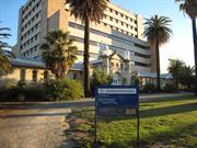
02438 King Edward Memorial Hospital for Women
Individual Building or Group
| Epoch | General | Specific |
|---|---|---|
| Original Use | HEALTH | Housing or Quarters |
| Present Use | HEALTH | Housing or Quarters |
This information is provided voluntarily as a public service. The information provided is made available in good faith and is derived from sources believed to be reliable and accurate. However, the information is provided solely on the basis that readers will be responsible for making their own assessment of the matters discussed herein and are advised to verify all relevant representations, statements and information.
Constructed from 1922, Constructed from 1928
Refer to HCWA's Assessment Documentation of Places for Entry in the Register of Heritage Places.
Two storeys, brickwork and a terracotta tiled roof, in simple form, with encircling two storey verandahs on paired columns. reflects the influence of the Californian Bungalow style. For more detail refer to HCWA's Assessment Documentation of Places for Entry in the Register of Heritage Places. (Ref: HCWA & AHC assessment documentation.)
Carson House (1922-28) was designed by W B Hardwick and built by Todd Brothers. It was originally a nurses' quarters, a new labour ward and theatre (ground floor). Additions were carried out in 1926 (ante-natal and post-natal clinics) attached to the original stone building with a covered walkway, and a second storey in 1927/28 (medical officers' quarters) to the stone building. The building was named after Sister Carson, assistant to Matron Agnes Walsh in the 1920s. For more detail refer to HCWA's Assessment Documentation of Places for Entry in the Register of Heritage Places. (Ref: HCWA & AHC assessment documentation.) The area of West Subiaco developed primarily as residential from the early 1900s. Most of the main roads were gazetted by 1883, but were unsealed until the 1900s. Derby Road was named after Lord Derby, Secretary for Colonies. Hensman Road was named after Mr A P Hensman, Judge and Attorney General. The first houses were established in streets closest to the commercial area along Hay Street and Rokeby Road, and the area west of the civic square, including Barker, Bagot, Hensman, Douglas, Lawler, Loretto, Raphael, Denis and Rowland Streets. Another early subdivision was located along Rokeby Road, and included Rawson, Campbell, Coolgardie, Duke, and Union Streets. Most of the West Subiaco precinct was developed by 1915, with the most recent houses to be built by c1925 in the south west corner. Two land releases, called Redfern Estates No. 1 and No. 2, were situated along the railway line opposite the new suburb of Daglish. Early public buildings in the West Subiaco precinct included the Industrial School on Barker Road (1897), later converted into King Edward Memorial Hospital in 1916. (Sources: Wise's Post Office Directory 1905-1925; Real Estate Maps, Battye Library Collection; Spillman, Ken, Identity Prized: A History of Subiaco, City of Subiaco, UWA Press, 1985; Chate, A, H., History of Subiaco, c1952.)
| Name | Type | Year From | Year To |
|---|---|---|---|
| W B Hardwick | Architect | - | - |
This information is provided voluntarily as a public service. The information provided is made available in good faith and is derived from sources believed to be reliable and accurate. However, the information is provided solely on the basis that readers will be responsible for making their own assessment of the matters discussed herein and are advised to verify all relevant representations, statements and information.
Barker Rd Subiaco
Harvey House
Subiaco
Metropolitan
Constructed from 1939
| Type | Status | Date | Documents |
|---|---|---|---|
| (no listings) |
| Type | Status | Date | Documents |
|---|---|---|---|
| (no listings) |
| Type | Status | Date | Grading/Management | |
|---|---|---|---|---|
| Category | ||||
| Municipal Inventory | Adopted | 24 Sep 2002 | Exceptional Significance (Level 1) | |
| Classified by the National Trust | Recorded | 11 May 1981 | ||
| Register of the National Estate | Permanent | 18 Apr 1989 | ||
02438 King Edward Memorial Hospital for Women
Individual Building or Group
| Epoch | General | Specific |
|---|---|---|
| Original Use | EDUCATIONAL | Technical School |
| Present Use | EDUCATIONAL | Technical School |
This information is provided voluntarily as a public service. The information provided is made available in good faith and is derived from sources believed to be reliable and accurate. However, the information is provided solely on the basis that readers will be responsible for making their own assessment of the matters discussed herein and are advised to verify all relevant representations, statements and information.
Constructed from 1896, Constructed from 1916
Refer to HCWA's Assessment Documentation of Places for Entry in the Register of Heritage Places.
The former Industrial School (1896) is a good example of the Federation Romanesque revival style, with a large central arched entrance between domed turrets under a stone pediment. For more detail refer to HCWA's Assessment Documentation of Places for Entry in the Register of Heritage Places. (Ref: HCWA & AHC assessment documentation.)
The former Industrial School (1896) was a reformatory for delinquent and destitute children, designed by Robert Haddon (later prominent in Melbourne) under George Temple Poole, PWD Chief Architect. Additions were carried out in 1898, 1901and 1913. It was converted to become the State's first public maternity hospital, KEMH, in 1916, after much public campaigning. Edith Cowan (1861-1932) was a leading member of the committee to establish the hospital. When the Main Entry Block was built (1939) the fmr Industrial School became the Ante-natal clinic. In 1949 it was renamed Harvey House, in honour of a fmr matron. Since 1988 it has been a Medical Museum. For more detail refer to HCWA's Assessment Documentation of Places for Entry in the Register of Heritage Places. (Ref: HCWA & AHC assessment documentation.) The area of West Subiaco developed primarily as residential from the early 1900s. Most of the main roads were gazetted by 1883, but were unsealed until the 1900s. Derby Road was named after Lord Derby, Secretary for Colonies. Hensman Road was named after Mr A P Hensman, Judge and Attorney General. The first houses were established in streets closest to the commercial area along Hay Street and Rokeby Road, and the area west of the civic square, including Barker, Bagot, Hensman, Douglas, Lawler, Loretto, Raphael, Denis and Rowland Streets. Another early subdivision was located along Rokeby Road, and included Rawson, Campbell, Coolgardie, Duke, and Union Streets. Most of the West Subiaco precinct was developed by 1915, with the most recent houses to be built by c1925 in the south west corner. Two land releases, called Redfern Estates No. 1 and No. 2, were situated along the railway line opposite the new suburb of Daglish. Early public buildings in the West Subiaco precinct included the Industrial School on Barker Road (1897), later converted into King Edward Memorial Hospital in 1916. (Sources: Wise's Post Office Directory 1905-1925; Real Estate Maps, Battye Library Collection; Spillman, Ken, Identity Prized: A History of Subiaco, City of Subiaco, UWA Press, 1985; Chate, A, H., History of Subiaco, c1952.)
| Name | Type | Year From | Year To |
|---|---|---|---|
| Robert Haddon | Architect | - | - |
This information is provided voluntarily as a public service. The information provided is made available in good faith and is derived from sources believed to be reliable and accurate. However, the information is provided solely on the basis that readers will be responsible for making their own assessment of the matters discussed herein and are advised to verify all relevant representations, statements and information.
Cnr Barker Rd & Railway Pde Subiaco
Address includes: 121 Railway Rd & 374 Bagot Rd, Subiaco. 374 Bagot Road
Agnes Walsh Nurses Home
Carson House
Harvey House
Industrial School
Main Entry Block
Subiaco
Metropolitan
Constructed from 1897 to 2001
| Type | Status | Date | Documents |
|---|---|---|---|
| Heritage List | Adopted | 24 Jul 2014 | |
| State Register | Registered | 20 Dec 2002 | HCWebsite.Listing+ListingDocument, HCWebsite.Listing+ListingDocument |
| Type | Status | Date | Documents |
|---|---|---|---|
| (no listings) |
| Type | Status | Date | Grading/Management | |
|---|---|---|---|---|
| Category | ||||
| Register of the National Estate | Permanent | 18 Apr 1989 | ||
| Classified by the National Trust | Classified | 11 May 1981 | ||
| Survey of 20th Ctry Architecture | Completed | 01 Mar 1988 | ||
| Other Legal Agreement | Completed | 02 Oct 2002 | ||
| Survey of Women's Employment AHC | Recorded | 01 Sep 2002 | ||
| Municipal Inventory | Adopted | 24 Sep 2002 | Exceptional Significance (Level 1) | |
| Name | Type | Year From | Year To |
|---|---|---|---|
| Len Walters, 1950s major buildings | Architect | - | - |
| A. E. Clare, Principal Architect, inter-war period buildings | Architect | - | - |
| Robert Haddon, the Government Industrial School | Architect | - | - |
| Library Id | Title | Medium | Year Of Publication |
|---|---|---|---|
| 5583 | Radio communications facilities King Edward Memorial Hospital : application for development approval (final). | Report | 2002 |
| 6379 | High hopes. | Book | 2003 |
| 10198 | G.W.Finn: architectural photographs and projects | Book | 1995 |
| 11855 | King Edward Memorial Hospital A Block - Lifts | Archival Record | 2021 |
| 6082 | King Edward Memorial Hospital : heritage impact. | C D Rom | 2002 |
| 8065 | A chain of care : a history of the Silver Chain Nursing Association 1905 - 2005. | Book | 2005 |
Individual Building or Group
| Epoch | General | Specific |
|---|---|---|
| Original Use | EDUCATIONAL | Technical School |
| Present Use | HEALTH | Housing or Quarters |
| Original Use | HEALTH | Hospital |
| Other Use | HEALTH | Hospital |
| Style |
|---|
| Post-War International |
| Inter-War Functionalist |
| Federation Free Style |
| Type | General | Specific |
|---|---|---|
| Wall | BRICK | Common Brick |
| General | Specific |
|---|---|
| SOCIAL & CIVIC ACTIVITIES | Community services & utilities |
This information is provided voluntarily as a public service. The information provided is made available in good faith and is derived from sources believed to be reliable and accurate. However, the information is provided solely on the basis that readers will be responsible for making their own assessment of the matters discussed herein and are advised to verify all relevant representations, statements and information.
Constructed from 1896, Constructed from 1952
Refer to HCWA's Assessment Documentation of Places for Entry in the Register of Heritage Places.
The group of four buildings demonstrates the changing architectural influences on public works from 1896 to 1952. Each building has architectural significance, and is an important element of the townscape. The former Industrial School (1896) is a good example of the Federation Romanesque revival style, with a large central arched entrance between domed turrets under a stone pediment. Carson House (1922-28) was originally one storey. It was later extended to become a two storey load bearing brick building of simple form with a terracotta tiled roof. Constructed of simple materials of brick and render walling between full height door and window openings and a tiled roof. The deep double height verandahs on all sides with shingled valance/bressumer with inset timber balustading unify the building. The paired verandah posts make it a late example of Arts and Crafts style. Overall the building reflects the influence of Californian Bungalow style. Main Entry Block (1939) is an interwar functionalist style, with brown and cream brickwork and cream and green terracotta tiling, in a symmetrical form with rounded corners and horizontal emphasis, characteristic of the style. The central entry features a two storied tiled frame surmounted by a tiled plaque in an art deco style with elaborate brickwork detail. Agnes Walsh Nurse's Home (1952) is a six storey brick building in a post war international style, constructed of reinforced concrete frame with exposed brick walls, plain smooth walls of contrasting textures, non-rectangular shapes constrasted with rectangular, cubiform shape clad with curtain walls, vertical sliding timber windows, spaced to express the building's residential function, and a flat insulated roof. It reflects the economic climate of the post war recovery and the resulting simplified forms of the international modern architectural movement. Influence of Dutch architect Dudok can be clearly seen in the facade treatment, via the band of dark brickwork across the lower floor. There is a free form single storey recreation wing located to the south of the main block. For more detail refer to HCWA's Assessment Documentation of Places for Entry in the Register of Heritage Places. (Ref: HCWA & AHC assessment documentation.)
A group of four buildings which each represent a major stage in the development of the King Edward Memorial Hospital from 1896 to 1952. The former Industrial School (1896) was a reformatory for delinquent and destitute children, designed by Robert Haddon (later prominent in Melbourne) under George Temple Poole, PWD Chief Architect. Additions were carried out in 1898, 1901and 1913. It was converted to become the State's first public maternity hospital, KEMH, in 1916, after much public campaigning. Edith Cowan (1861-1932) was a leading member of the committee to establish the hospital. When the Main Entry Block was built (1939) the fmr Industrial School became the Ante-natal clinic. In 1949 it was renamed Harvey House, in honour of a fmr matron. Since 1988 it has been a Medical Museum. Carson House (1922-28) was designed by W B Hardwick and built by Todd Brothers. It was originally a nurse's quarters, a new labour ward and theatre (ground floor). Additions were carried out in 1926 (ante-natal and post-natal clinics) attached to the original stone building with a covered walkway, and a second storey in 1927/28 (medical officers' quarters) to the stone building. However, the hospital was still in need of more room. The Main Entry Block (1939) was built to a design by PWD Architect A E Clare. It changed the layout of the hospital by changing the main entry from Barker Road to Bagot Road. Agnes Walsh Nurse's Home (formerly 'Nurses Quarters') (1952) was designed by PWD Architect Gordon W Finn under A E Clare. Finn was one of the main exponents of the introduction of the International style of architecture in WA during the 1940s and 1950s, after travels overseas. The building was officially opened on 15 January 1953 by Hon. Dame Florence Cardell-Oliver OBE MLA. The building was the recipient of 1955 Royal Institute of British Architects Bronze Medal. The building was renamed in 1971, in honour of Matron Agnes Walsh OBE, matron of KEMH from 1922 to 1954. The Main Building was extended in 1962. For more detail refer to HCWA's Assessment Documentation of Places for Entry in the Register of Heritage Places. (Ref: HCWA & AHC assessment documentation.) The area of West Subiaco developed primarily as residential from the early 1900s. Most of the main roads were gazetted by 1883, but were unsealed until the 1900s. Derby Road was named after Lord Derby, Secretary for Colonies. Hensman Road was named after Mr A P Hensman, Judge and Attorney General. The first houses were established in streets closest to the commercial area along Hay Street and Rokeby Road, and the area west of the civic square, including Barker, Bagot, Hensman, Douglas, Lawler, Loretto, Raphael, Denis and Rowland Streets. Another early subdivision was located along Rokeby Road, and included Rawson, Campbell, Coolgardie, Duke, and Union Streets. Most of the West Subiaco precinct was developed by 1915, with the most recent houses to be built by c1925 in the south west corner. Two land releases, called Redfern Estates No. 1 and No. 2, were situated along the railway line opposite the new suburb of Daglish. Early public buildings in the West Subiaco precinct included the Industrial School on Barker Road (1897), later converted into King Edward Memorial Hospital in 1916. (Sources: Wise's Post Office Directory 1905-1925; Real Estate Maps, Battye Library Collection; Spillman, Ken, Identity Prized: A History of Subiaco, City of Subiaco, UWA Press, 1985; Chate, A, H., History of Subiaco, c1952.)
High degree of integrity.
This information is provided voluntarily as a public service. The information provided is made available in good faith and is derived from sources believed to be reliable and accurate. However, the information is provided solely on the basis that readers will be responsible for making their own assessment of the matters discussed herein and are advised to verify all relevant representations, statements and information.
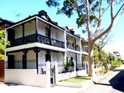
2-8 Catherine St Subiaco
Subiaco
Metropolitan
Constructed from 1906
| Type | Status | Date | Documents |
|---|---|---|---|
| Heritage List | Adopted | 22 May 2012 | |
| State Register | Registered | 21 Jan 1997 | HCWebsite.Listing+ListingDocument, HCWebsite.Listing+ListingDocument |
| Type | Status | Date | Documents |
|---|---|---|---|
| (no listings) |
| Type | Status | Date | Grading/Management | |
|---|---|---|---|---|
| Category | ||||
| Municipal Inventory | Adopted | 24 Sep 2002 | Exceptional Significance (Level 1) | |
Individual Building or Group
| Epoch | General | Specific |
|---|---|---|
| Present Use | RESIDENTIAL | Terrace housing |
| Original Use | RESIDENTIAL | Terrace housing |
| Style |
|---|
| Federation Filigree |
| Type | General | Specific |
|---|---|---|
| Wall | BRICK | Common Brick |
| Roof | METAL | Corrugated Iron |
| General | Specific |
|---|---|
| DEMOGRAPHIC SETTLEMENT & MOBILITY | Settlements |
This information is provided voluntarily as a public service. The information provided is made available in good faith and is derived from sources believed to be reliable and accurate. However, the information is provided solely on the basis that readers will be responsible for making their own assessment of the matters discussed herein and are advised to verify all relevant representations, statements and information.
Constructed from 1906
Refer to HCWA's Assessment Documentation of Places for Entry in the Register of Heritage Places.
For detail refer to HCWA's Assessment Documentation of Places for Entry in the Register of Heritage Places.
One of the few remaining terraces in WA, containing features similar to those in Melbourne & Sydney. Tenement houses for the working class, built during a period of rapid growth in Perth following the 1890s gold boom. For more detail refer to HCWA's Assessment Documentation of Places for Entry in the Register of Heritage Places. North Subiaco developed as an area for residential and for the provision of community facilities from the early 1900s. The opening of the railway line established Subiaco as an area within close proximity to Perth for investors and as a place for people to settle. With sales by Real estate release common, land near the railway platform was the first to be sold. North of Subiaco Road was released as 'Subiaco Estate' in 1895 and south of Roberts Road (formally Mueller Road) was released in 1896. People settled along either side of the railway line, as the more affordable prices made the land accessible to workers. Recreational facilities with the Municipal Gardens and Subiaco Oval being established for the local Football and Cricket Club also played an important role in attracting residents to the new area. Subiaco became known as the home of hospitals, and health care for the young became accessible with the first wing of a Children's Hospital at the corner of Thomas Road and Meuller Road (now Princess Margaret Hospital) opening in 1909. (Sources: Wise's Post Office Directory 1900-1930; Real Estate Maps, Battye Library Collection; Spillman, Ken Identity Prized: a history of Subiaco, City of Subiaco, UWA Press, 1985, pp.51-75, 160-169.
This information is provided voluntarily as a public service. The information provided is made available in good faith and is derived from sources believed to be reliable and accurate. However, the information is provided solely on the basis that readers will be responsible for making their own assessment of the matters discussed herein and are advised to verify all relevant representations, statements and information.
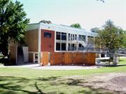
160 Hamersley Rd Subiaco
Subiaco
Metropolitan
| Type | Status | Date | Documents |
|---|---|---|---|
| Heritage List | Adopted | 26 Aug 2014 |
| Type | Status | Date | Documents |
|---|---|---|---|
| (no listings) |
| Type | Status | Date | Grading/Management | |
|---|---|---|---|---|
| Category | ||||
| Municipal Inventory | Adopted | 24 Feb 2002 | Considerable Significance (Level 2) | |
02434 Subiaco Primary School
Individual Building or Group
| Epoch | General | Specific |
|---|---|---|
| Original Use | EDUCATIONAL | Primary School |
| Present Use | EDUCATIONAL | Other |
| Style |
|---|
| Federation Queen Anne |
| Type | General | Specific |
|---|---|---|
| Roof | METAL | Corrugated Iron |
| Wall | BRICK | Common Brick |
This information is provided voluntarily as a public service. The information provided is made available in good faith and is derived from sources believed to be reliable and accurate. However, the information is provided solely on the basis that readers will be responsible for making their own assessment of the matters discussed herein and are advised to verify all relevant representations, statements and information.
Constructed from 1911
160 Hamersley Road, Subiaco is of cultural heritage significance • As a well-executed example of the Federation Arts and Crafts style with some fine details in brickwork and timberwork. • For its social value to the many members of the community who are associated with the place either as students, parents, staff members or visitors to the place. • As a demonstration of that period of time in the early 1910s when Subiaco was undergoing considerable growth and services had to be provided for all levels of the community.
This red brick and iron former school building with tuckpointed finish demonstrates the Federation Arts and Crafts style. The building is of asymmetric plan form to Hamersley Road with a shallow gabled element to the western end of the façade. The gable is vented with wide battened and bossed eaves and sits above a set of three tall openings creating the main feature of the façade. The windows are timber framed 6-over-6 sashes with a smaller 6 paned hopper opening above. The security grilles detract from the aesthetic of the place. The feature elevation is further enlivened by brick quoining to the edges. The remainder of the façade presents in a symmetrical form with a central doorway flanked by a window either side. The door is accessed by timber steps with timber handrail/balustrade and an iron canopy over the top part of the stairs. The flanking windows match the other openings in the façade being 6-over-6 sash windows with hopper openings. There is small fanlight above the door. To the rear a timber framed and weatherboard lean-to styled addition has been constructed with a new shade structure projecting from the lean-to. The roof of the main building continues down over the lean-to with the join in the eaves being visible. The east elevation is blank with no discernible features apart from the vented gable detail. The west elevation mirrors the east elevation in form and presentation.
The building which is currently occupied by the Subiaco After School Care was built in 1914 for the Subiaco Primary School as classrooms for the Intermediate School. The additional classrooms were constructed to alleviate the overcrowding experienced at the school in the years before World War One. Since its establishment in 1897 the school grew rapidly as the population of the suburb expanded with many people settling in Western Australia as a result of the gold discoveries in the east and the subsequent wealth brought to the colony. Subiaco was one of the suburbs surrounding central Perth that was developed for working families wanting to live near the city and the railway line. The school underwent many additions between 1897 and 1912; eight classrooms were added to the senior school and six to the junior school. In 1914 a contract for the construction of the Intermediate School, designed by the Public Works Department of WA, was awarded to contractor J. Lake for £808.11.6 and was to be completed by 13 May 1914. The building consisted of two classrooms and a verandah and proposals for extending the Intermediate School were put forward in both 1919 and 1922. In 1922, 194 pupils were enrolled in the Intermediate School with an average of 180 attending. However the proposed additions were not undertaken and students were accommodated in rental premises when necessary. The halls of the nearby Presbyterian Church and Methodist Church were used as temporary classrooms. By 1927, enrolment numbers had declined and the Intermediate School amalgamated with the senior school. Consequently the building was used for the study of ‘Household Management’, a course for girls later named domestic science. The building was converted for this use by contractor W.J. Fergus for the sum of £455.7.0 to be completed by 22 October 1927. The building was used for this function until the 1950s and was then occupied by a branch of the Education Department: the In-Service Centre, or the Teachers Centre for Continuing Education, which was responsible for running a Higher Certificate (HC) course for teachers who wished to complete an additional 3rd or 4th year study to their existing tertiary level qualifications. In c1977, the Museum of Childhood moved into one room of the former Intermediate School. During the 1980s the In-service Centre and the Museum of Childhood vacated the premises and in 1992 the Electoral Education Centre moved into the building. The Electoral Education Centre relocated to the constitution centre in West Perth c1997 and the former Intermediate School has since been occupied by the ‘After School Care Service’ for Subiaco Primary School. Since its construction the basic form of the building has undergone minimal change. Changes to accommodate different uses has affected internal fitouts and during some periods there have been enclosures and patios added to the external elevations.
Integrity - High – although no longer used as a school it still provides a child and educational related function. Authenticity - High – The place has undergone minimal external additions and alterations. Rarity/Representativeness - The place is not rare as an example of a school building in the Federation Arts and Crafts style. The place is a good representative example of a school building from the early 20th century and with some fine external details.
| Ref ID No | Ref Name | Ref Source | Ref Date |
|---|---|---|---|
| Heritage Assessment of 160 Hamersley Road, Subiaco prepared by Hocking Heritage Studio | City of Subiaco | May 2014 |
This information is provided voluntarily as a public service. The information provided is made available in good faith and is derived from sources believed to be reliable and accurate. However, the information is provided solely on the basis that readers will be responsible for making their own assessment of the matters discussed herein and are advised to verify all relevant representations, statements and information.
180 Hamersley Rd Subiaco
Subiaco
Metropolitan
Constructed from 1957
| Type | Status | Date | Documents |
|---|---|---|---|
| (no listings) |
| Type | Status | Date | Documents |
|---|---|---|---|
| (no listings) |
| Type | Status | Date | Grading/Management | |
|---|---|---|---|---|
| Category | ||||
| Register of the National Estate | Nominated | 03 Jun 1982 | ||
| Classified by the National Trust | Classified | 03 Aug 1981 | ||
| Register of the National Estate | Indicative Place | |||
04653 Subiaco Theatre Centre
Individual Building or Group
| Epoch | General | Specific |
|---|---|---|
| Original Use | GOVERNMENTAL | Town, Shire or District Hall |
| Present Use | SOCIAL\RECREATIONAL | Other Community Hall\Centre |
| Type | General | Specific |
|---|---|---|
| Roof | ASBESTOS | Fibrous Cement, corrugated |
| Wall | CONCRETE | Reinforced Concrete |
| Wall | BRICK | Common Brick |
| General | Specific |
|---|---|
| SOCIAL & CIVIC ACTIVITIES | Government & politics |
This information is provided voluntarily as a public service. The information provided is made available in good faith and is derived from sources believed to be reliable and accurate. However, the information is provided solely on the basis that readers will be responsible for making their own assessment of the matters discussed herein and are advised to verify all relevant representations, statements and information.
180 Hamersley Rd Subiaco
Civic Hall
Rankin Gardens, Subiaco Arts Centre
Subiaco
Metropolitan
Constructed from 1957 to 1984
| Type | Status | Date | Documents |
|---|---|---|---|
| Heritage List | Adopted | 26 Jun 2012 | |
| State Register | Registered | 15 May 1998 | HCWebsite.Listing+ListingDocument, HCWebsite.Listing+ListingDocument |
| Type | Status | Date | Documents |
|---|---|---|---|
| (no listings) |
| Type | Status | Date | Grading/Management | |
|---|---|---|---|---|
| Category | ||||
| Municipal Inventory | Adopted | 24 Sep 2002 | Exceptional Significance (Level 1) | |
| Classified by the National Trust | Classified | 08 Jun 1998 | ||
| Survey of 20th Ctry Architecture | Completed | 01 Mar 1988 | ||
24360 Civic and Cultural Centre Conservation Area
Major refurbishment in 2005/06 included changing entry to be from Bagot Road, rearranging internal spaces including moving the steel staircase & installation of a lift for disabled access. New seats were installed. Concrete cancer was removed. Surrounding grounds were landscaped.
| Name | Type | Year From | Year To |
|---|---|---|---|
| Kenneth Broadhurst, Ryan and Evan, architectural firm - 1968 alterations | Architect | - | - |
| Peter Parkinson | Architect | - | - |
| John Oldham, landscape architect | Architect | - | - |
| F.G.B. Hawkins & Desmond Sands, architectural firm | Architect | - | - |
| Library Id | Title | Medium | Year Of Publication |
|---|---|---|---|
| 7729 | Subiaco theatre centre archival record. | Archival Record | 2005 |
| 5701 | Subiaco Civic Hall (fmr), Subiaco WA : heritage assessment. | Heritage Study {Other} | 1996 |
| 6379 | High hopes. | Book | 2003 |
Individual Building or Group
| Epoch | General | Specific |
|---|---|---|
| Original Use | SOCIAL\RECREATIONAL | Other Community Hall\Centre |
| Present Use | SOCIAL\RECREATIONAL | Theatre or Cinema |
| Original Use | GOVERNMENTAL | Town, Shire or District Hall |
| Style |
|---|
| Post-War International |
| Type | General | Specific |
|---|---|---|
| Roof | ASBESTOS | Fibrous Cement, corrugated |
| Wall | CONCRETE | Concrete Block |
| General | Specific |
|---|---|
| SOCIAL & CIVIC ACTIVITIES | Government & politics |
| SOCIAL & CIVIC ACTIVITIES | Sport, recreation & entertainment |
This information is provided voluntarily as a public service. The information provided is made available in good faith and is derived from sources believed to be reliable and accurate. However, the information is provided solely on the basis that readers will be responsible for making their own assessment of the matters discussed herein and are advised to verify all relevant representations, statements and information.
Constructed from 1957, Constructed from 1968
Refer to HCWA's Assessment Documentation of Places for Entry in the Register of Heritage Places.
Two storey, Post-War International style concrete framed building and floor with external walls of pastel brick and glass panels. Roof is constructed of steel trusses carrying corrugated asbestos. Internally, foyer floors are black terrazzo and walls are pastel brick. Hall floors are wandoo, and walls are vertical blackbutt boarding with fibrous plaster features and large wall mirrors. Ceilings are suspended fibrous plaster. For more detail refer to HCWA's Assessment Documentation of Places for Entry in the Register of Heritage Places.
Foundation Stone laid by Sir Charles Gairdner, Governor of WA, 17.11.56. Mayor at the time was J H Abrahams. The building officially opened 30 November 1957 by Premier A Hawke as the Civic Hall. Designed by Hawkins & Sands, it accommodated 800 people for seated functions. Building comprises two halls which can be used separately or together, with a public gallery, stage, dressing rooms, spacious entrance foyer and cloak room. It was refurbished in 1968, and in 1984 converted into the Theatre Centre, housing the Hole in the Wall Theatre. For more detail refer to HCWA's Assessment Documentation of Places for Entry in the Register of Heritage Places. (Ref: HCWA & AHC assessment documentation.) The civic square is in the heart of Subiaco, bounded by Rokeby, Hamersley, Hensman and Bagot Roads. The eastern portion of the civic square has been used for civic purposes since 1899 when the first council chambers was built next to the original post office and library on the corner of Bagot and Rokeby Roads. It also housed the Literary Institute. Sir John Forrest opened the Council Chambers on 3.11.1900. The space was soon inadequate and a foundation stone was laid in 1909 for a larger chambers and hall next to it. The old chambers became the Mechanics' Institute. The present Council Chambers was built in 1968 and the 1909 chambers was demolished in 1971. The present library was built in 1970. The civic area also contains the primary school (1897), the Uniting Church, the City Hall (1957), and is marked by the War Memorial clock tower on the corner, built in 1922, and the Norfolk Pines planted in 1899 for the original Municipal gardens. (Ref: Spillman, Ken, Identity Prized: A History of Subiaco, City of Subiaco, UWA Press, 1985, pp. 121-2, 305-7.)
This information is provided voluntarily as a public service. The information provided is made available in good faith and is derived from sources believed to be reliable and accurate. However, the information is provided solely on the basis that readers will be responsible for making their own assessment of the matters discussed herein and are advised to verify all relevant representations, statements and information.
195 Hay St Subiaco
Formerly No.s 201 or 197 Hay Street
Distribution Substation, Electric Light Stn
State Electricity Commission Sub Station
Subiaco
Metropolitan
Constructed from 1923
| Type | Status | Date | Documents |
|---|---|---|---|
| Heritage List | Adopted | 26 May 2012 | |
| State Register | Registered | 30 Jun 2009 | HCWebsite.Listing+ListingDocument, HCWebsite.Listing+ListingDocument |
| Type | Status | Date | Documents |
|---|---|---|---|
| (no listings) |
| Type | Status | Date | Grading/Management | |
|---|---|---|---|---|
| Category | ||||
| Municipal Inventory | Adopted | 24 Sep 2002 | Exceptional Significance (Level 1) | |
Generally the building is in good condition. There are some isolated sections of fretted mortar and some missing or broken tiles.
| Library Id | Title | Medium | Year Of Publication |
|---|---|---|---|
| 9935 | Electricity generation, transmission and distribution in Western Australia: representation on the register of heritage places. | Report | 2007 |
| 8519 | First light: The development of a State Government Electricity and Gas supply. Part one. | Book | 0 |
| 9716 | Electricity generation, transmission and distribution in Western Australia: representation on the register of heritage places. | Brochure | 2007 |
Individual Building or Group
| Epoch | General | Specific |
|---|---|---|
| Present Use | GOVERNMENTAL | Power Station |
| Original Use | GOVERNMENTAL | Power Station |
| Style |
|---|
| Federation Bungalow |
| Type | General | Specific |
|---|---|---|
| Roof | TILE | Terracotta Tile |
| Wall | BRICK | Common Brick |
| General | Specific |
|---|---|
| SOCIAL & CIVIC ACTIVITIES | Government & politics |
| DEMOGRAPHIC SETTLEMENT & MOBILITY | Technology & technological change |
| DEMOGRAPHIC SETTLEMENT & MOBILITY | Government policy |
| OUTSIDE INFLUENCES | Water, power, major t'port routes |
This information is provided voluntarily as a public service. The information provided is made available in good faith and is derived from sources believed to be reliable and accurate. However, the information is provided solely on the basis that readers will be responsible for making their own assessment of the matters discussed herein and are advised to verify all relevant representations, statements and information.
Constructed from 1923
The place has considerable aesthetic significance as a brick and tile structure dating from the early 1900s which contributes to the heritage character of the area. It has historic significance as an electrical substation associated with the provision of electricity to the suburb of Subiaco and as such reflects the history of settlement of the area.
Red brick and tile sub-station with gable roof and exposed rafters. Scroll finials to gables. Three metal vents in roof. Rough-cast rendering either side of door opening extending to top of wall. Tiled awning with timber brackets over double doors.
In 1903 the Subiaco City Council opened its own electrical supply plant to provide for the needs of the municipality on land north of the Axon Street railway crossing. The supply of electricity to Subiaco was transferred to the City of Perth system in 1923. (Spillman pp 136-8 and 222-3). Subiaco began to develop as a residential and commercial area in the 1890s, with the first buildings being established along the railway line. In 1895 Rokeby Road was not yet gazetted and Hay Street was called Broome Road. By the turn of the century most of the main roads in central Subiaco were built, including Rokeby, Heytsebury, Hamersley, Bagot, Townshend, Park and Nicholson Roads. Many businesses had been established in Broome Road. Broome Road was named after Governor Broome, and was renamed Hay Street after Vice-Secretary of Colonies, 1829. There were many land releases in the late 1890s and early 1900s as Subiaco become a popular place to settle, and businesses were attracted to the opportunity of opening in a new but stable suburb. The Rokeby Road and Hay Street commercial area was firmly established by 1915. Over the years the nature of businesses have changed. Originally there were estate agents, dressmakers, tailors, confectioners, drapers, grocers, restaurateurs and bakers; in fact most shopping could be done without leaving the suburb. (Sources: Wise's Post Office Directory 1893-1915; Real Estate Maps, Battye Library Collection; Spillman, Ken, Identity Prized: A History of Subiaco, City of Subiaco, UWA Press, 1985, pp. 92-110; Chate, A. H., History of Subiaco, c1952.)
This information is provided voluntarily as a public service. The information provided is made available in good faith and is derived from sources believed to be reliable and accurate. However, the information is provided solely on the basis that readers will be responsible for making their own assessment of the matters discussed herein and are advised to verify all relevant representations, statements and information.
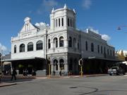
455-465 Hay St Subiaco
Cnr of Rokeby Rd & Hay St
Murphy’s Hotel
Subiaco
Metropolitan
Constructed from 1898 to 1990
| Type | Status | Date | Documents |
|---|---|---|---|
| Heritage List | Adopted | 26 May 2009 | |
| State Register | Registered | 20 Oct 2015 | HCWebsite.Listing+ListingDocument, HCWebsite.Listing+ListingDocument |
| Type | Status | Date | Documents |
|---|---|---|---|
| (no listings) |
| Type | Status | Date | Grading/Management | |
|---|---|---|---|---|
| Category | ||||
| Survey of 20th Ctry Architecture | Completed | 01 Mar 1988 | ||
| Classified by the National Trust | Recorded | 03 Aug 1981 | ||
| Statewide Hotel Survey | Completed | 01 Nov 1997 | ||
| Register of the National Estate | Indicative Place | |||
| Municipal Inventory | Adopted | 24 Sep 2002 | Exceptional Significance (Level 1) | |
17473 Rokeby Road Precinct, Subiaco
| Name | Type | Year From | Year To |
|---|---|---|---|
| H S (Henry Stirling) Trigg | Architect | 1898 | - |
| Library Id | Title | Medium | Year Of Publication |
|---|---|---|---|
| 9244 | Subiaco Hotel. | Heritage Study {Cons'n Plan} | 2008 |
Individual Building or Group
| Epoch | General | Specific |
|---|---|---|
| Present Use | COMMERCIAL | Hotel, Tavern or Inn |
| Original Use | COMMERCIAL | Hotel, Tavern or Inn |
| Style |
|---|
| Federation Romanesque |
| Type | General | Specific |
|---|---|---|
| Roof | METAL | Corrugated Iron |
| Wall | BRICK | Common Brick |
| General | Specific |
|---|---|
| DEMOGRAPHIC SETTLEMENT & MOBILITY | Land allocation & subdivision |
| OCCUPATIONS | Commercial & service industries |
| SOCIAL & CIVIC ACTIVITIES | Sport, recreation & entertainment |
| OUTSIDE INFLUENCES | Depression & boom |
This information is provided voluntarily as a public service. The information provided is made available in good faith and is derived from sources believed to be reliable and accurate. However, the information is provided solely on the basis that readers will be responsible for making their own assessment of the matters discussed herein and are advised to verify all relevant representations, statements and information.
Constructed from 1970, Constructed from 1898
The place is a landmark in the Subiaco Town Centre. It is a finely detailed and unusual example of a hotel showing the influence of the Federation Anglo Dutch style.
Stripped of its tower and two storeyed verandahs, the building has lost some of its former distinction. Three storey corner tower, gabled north wall and pedimented west wall. Original detail shows elements of Neo Romanesque and Art Nouveau.
Designer of the Hotel has not been established. It is one of the most original hotel designs of the period, and a notable landmark in a prominent location. The hotel was originally called 'Murphy's' because of its Irish licensee. Alterations were carried out in 1970 and 1990. Its current appearance is subdued in comparison to the original. Verandahs, cast iron lace and spire have been removed, and both street frontages have been extended. (AHC documentation; Spillman, Ken, Identity Prized: A History of Subiaco, City of Subiaco, UWA Press, 1985, pp. 186-189; Ball, J., Statewide Survey of Hotels 1829-1939, National Trust, 1997.) Subiaco began to develop as a residential and commercial area in the 1890s, with the first buildings being established along the railway line. In 1895 Rokeby Road was not yet gazetted and Hay Street was called Broome Road. By the turn of the century most of the main roads in central Subiaco were built, including Rokeby, Heytsebury, Hamersley, Bagot, Townshend, Park and Nicholson Roads. Many businesses had been established in Broome Road. Broome Road was named after Governor Broome, and was renamed Hay Street after Vice-Secretary of Colonies, 1829. There were many land releases in the late 1890s and early 1900s as Subiaco become a popular place to settle, and businesses were attracted to the opportunity of opening in a new but stable suburb. The Rokeby Road and Hay Street commercial area was firmly established by 1915. Over the years the nature of businesses have changed. Originally there were estate agents, dressmakers, tailors, confectioners, drapers, grocers, restaurateurs and bakers; in fact most shopping could be done without leaving the suburb. (Sources: Wise's Post Office Directory 1893-1915; Real Estate Maps, Battye Library Collection; Spillman, Ken, Identity Prized: A History of Subiaco, City of Subiaco, UWA Press, 1985, pp. 92-110; Chate, A. H., History of Subiaco, c1952.)
This information is provided voluntarily as a public service. The information provided is made available in good faith and is derived from sources believed to be reliable and accurate. However, the information is provided solely on the basis that readers will be responsible for making their own assessment of the matters discussed herein and are advised to verify all relevant representations, statements and information.
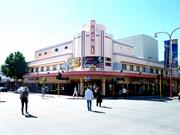
474 Hay St Subiaco
cnr Rokeby Rd & Hay St
Coliseum
Subiaco
Metropolitan
Constructed from 1936 to 1937
| Type | Status | Date | Documents |
|---|---|---|---|
| Heritage List | Adopted | 29 Nov 2009 | |
| State Register | Registered | 28 Feb 1995 | HCWebsite.Listing+ListingDocument, HCWebsite.Listing+ListingDocument |
| Type | Status | Date | Documents |
|---|---|---|---|
| (no listings) |
| Type | Status | Date | Grading/Management | |
|---|---|---|---|---|
| Category | ||||
| Classified by the National Trust | Classified | 05 Jun 1990 | ||
| Register of the National Estate | Registered | 30 Jun 1992 | ||
| Survey of 20th Ctry Architecture | Completed | 01 Mar 1988 | ||
| Art Deco Significant Bldg Survey | Classified | |||
| Municipal Inventory | Adopted | 24 Sep 2002 | Exceptional Significance (Level 1) | |
| Name | Type | Year From | Year To |
|---|---|---|---|
| William T Leighton - modifications | Architect | - | - |
| William G Bennett | Architect | - | - |
| Library Id | Title | Medium | Year Of Publication |
|---|---|---|---|
| 6986 | Regal Theatre Subiaco, WA : Stage 2 refurbishment conservation works for Baker Theatre Trust. (final report) | Conservation works report | 2004 |
| 11459 | Picture Palaces of the Golden West | Book | 2016 |
| 5945 | Regal Theatre : urgent and essential works. | C D Rom | 2001 |
| 6559 | Regal Theatre Subiaco, Heritage Program Refurbishment, Facade and Canopy : structural report. | Heritage Study {Other} | 2001 |
| 7404 | Regal Theatre, Subiaco : stage 3 conservation works. | Conservation works report | 2005 |
| 4993 | Regal Theatre, Subiaco: conservation plan. | Heritage Study {Cons'n Plan} | 2001 |
| 6521 | Regal Theatre Subiaco : Stage 2 refurbishment works (Part A). Mechanical Services Specification : upgrade existing air-conditioning (Part B). | Heritage Study {Other} | 2003 |
| 7688 | Regal theatre, Subiaco: final report - stage 3 conservation works. | Conservation works report | 2006 |
| 6379 | High hopes. | Book | 2003 |
| 5672 | Regal Theatre Subiaco : urgent reconstruction works to original canopy. | Conservation works report | 2002 |
| 5137 | Regal Theatre urgent external works / Hocking Planning and Architecture in association with Maitland Consulting Structural Engineering. | Heritage Study {Other} | 2001 |
| 9224 | Regal Theatre, Subiaco. Proposed unisex disabled toilet feasibilty study: Addendum issue. | Heritage Study {Other} | 2009 |
Individual Building or Group
| Epoch | General | Specific |
|---|---|---|
| Original Use | SOCIAL\RECREATIONAL | Theatre or Cinema |
| Present Use | SOCIAL\RECREATIONAL | Theatre or Cinema |
| Style |
|---|
| Inter-War Art Deco |
| Type | General | Specific |
|---|---|---|
| Wall | BRICK | Rendered Brick |
| Wall | RENDER | Smooth |
| General | Specific |
|---|---|
| SOCIAL & CIVIC ACTIVITIES | Sport, recreation & entertainment |
This information is provided voluntarily as a public service. The information provided is made available in good faith and is derived from sources believed to be reliable and accurate. However, the information is provided solely on the basis that readers will be responsible for making their own assessment of the matters discussed herein and are advised to verify all relevant representations, statements and information.
Constructed from 1936
Refer to HCWA's Assessment Documentation of Places for Entry in the Register of Heritage Places.
Three storey cinema, enhanced by a rounded facade which addresses the corner and establishes a relationship with the Subiaco Hotel diagonally opposite. The two-tiered, half cylindrical tower is accented with ribbed vertical bands, which emphasise the verticality of the stepped banner. The symmetrical design is silhouetted against the skyline. The interior is modern and simple with geometric Art Deco graphic and chromic trims, relying on boldness and mass for effect. There is a linear fountain design and letter 'R' accentuating the front doors. For more detail refer to HCWA's Assessment Documentation of Places for Entry in the Register of Heritage Places & AHC documentation.
Previously Coliseum Picture Gardens c1925, the Regal Theatre was built in its place in 1936 as a hardtop cinema for Ted and Mary Coade. They previously owned West's Picture Show. On the opposite side of Rokeby Road, the Regal Picture Gardens were constructed, and together they provided summer and winter entertainment to the public. The Regal was built to show movies with sound, as the 1930s sound revolution in film renewed interest in cinema-going and resulted in a boom in the entertainment industry in the interwar period. The cinemas of the 1930s were built in sleek, modern designs to reflect the modernity and sophistication of the new age. The Regal's position in the streetscape and town of Subicao and its relationship to the Subiaco Hotel diagonally opposite, relects the confidence in the growth of Perth and the State as a whole. Regal Theatre was named after King George VI who had recently ascended the throne. The design is attributed to William G Bennett, (Plaza Theatre) with later modifications by William T Leighton (Picadilly Theatre & Arcade, Como Theatre, Astor Theatre). The Regal opened on 27 April 1938. In 1946 it was sold to Clarence (Paddy) Baker, whose name is commemorated in the Trust which now owns the theatre. Paddy Baker was a colourful and State-wide known picture showman. In 1977 the Regal was converted into a place for live performance. In 1986 Paddy Baker died, leaving the Regal to the people of WA. The Regal Theatre is a fine and rare example of an intact interwar cinema in WA. For more detail refer to HCWA's Assessment Documentation of Places for Entry in the Register of Heritage Places. (Ref: AHC documentation; Subiaco Post 19.9.79) Subiaco began to develop as a residential and commercial area in the 1890s, with the first buildings being established along the railway line. In 1895 Rokeby Road was not yet gazetted and Hay Street was called Broome Road. By the turn of the century most of the main roads in central Subiaco were built, including Rokeby, Heytsebury, Hamersley, Bagot, Townshend, Park and Nicholson Roads. Many businesses had been established in Broome Road. Broome Road was named after Governor Broome, and was renamed Hay Street after Vice-Secretary of Colonies, 1829. There were many land releases in the late 1890s and early 1900s as Subiaco become a popular place to settle, and businesses were attracted to the opportunity of opening in a new but stable suburb. The Rokeby Road and Hay Street commercial area was firmly established by 1915. Over the years the nature of businesses have changed. Originally there were estate agents, dressmakers, tailors, confectioners, drapers, grocers, restaurateurs and bakers; in fact most shopping could be done without leaving the suburb. (Sources: Wise's Post Office Directory 1893-1915; Real Estate Maps, Battye Library Collection; Spillman, Ken, Identity Prized: A History of Subiaco, City of Subiaco, UWA Press, 1985, pp. 92-110; Chate, A. H., History of Subiaco, c1952.)
Refurbished in 1995 under the direction of Architects Donaldson, Smith & Hooke.
| Name | Type | Year From | Year To |
|---|---|---|---|
| Donaldson, Smith & Hooke, 1995 refurbishment | Architect | - | - |
This information is provided voluntarily as a public service. The information provided is made available in good faith and is derived from sources believed to be reliable and accurate. However, the information is provided solely on the basis that readers will be responsible for making their own assessment of the matters discussed herein and are advised to verify all relevant representations, statements and information.
Hay St, Price St, Atkinson Rd, Mouritzen Way, Wunderlich Rd & Wembley Ct Subiaco
Curtilage includes: 5 Price St, Subiaco.
Calyx Porcelain; Bristile Ltd
HL Brisbane and Wunderlich Limited
Subiaco
Metropolitan
Constructed from 1921 to 1984
| Type | Status | Date | Documents |
|---|---|---|---|
| Heritage Agreement | YES | 16 May 2014 | HCWebsite.Listing+ListingDocument |
| Heritage Agreement | YES | 15 Jun 2015 | HCWebsite.Listing+ListingDocument |
| Heritage Agreement | YES | 04 Dec 2014 | HCWebsite.Listing+ListingDocument |
| State Register | Registered | 07 Dec 2007 | HCWebsite.Listing+ListingDocument, HCWebsite.Listing+ListingDocument |
| Type | Status | Date | Documents |
|---|---|---|---|
| (no listings) |
| Type | Status | Date | Grading/Management | |
|---|---|---|---|---|
| Category | ||||
| (no listings) | ||||
| Name | Type | Year From | Year To |
|---|---|---|---|
| Forbes and Fitzhardinge (most post WWII additions) | Architect | - | - |
| Library Id | Title | Medium | Year Of Publication |
|---|---|---|---|
| 8861 | Calyx, Wembley Ware and Bristile china. | Book | 1989 |
| 7721 | Australian fine china, Subiaco: heritage assessment, November 2005. | Heritage Study {Other} | 0 |
| 7889 | Australian Fine China: the final piece of history. | Video | 2006 |
| 8709 | Subiaco redevelopment area : data sheets of heritage places. | Book | 1995 |
| 10054 | Recollections and reflections: Subi Centro | Electronic | 0 |
| 8853 | Pre-demolition archive record : Australian Fine China. | Archival Record | 2007 |
Individual Building or Group
| Epoch | General | Specific |
|---|---|---|
| Original Use | INDUSTRIAL\MANUFACTURING | Other |
| Present Use | INDUSTRIAL\MANUFACTURING | Other |
| Type | General | Specific |
|---|---|---|
| Wall | BRICK | Common Brick |
| Wall | ASBESTOS | Other Asbestos |
| Roof | TILE | Other Tile |
| General | Specific |
|---|---|
| DEMOGRAPHIC SETTLEMENT & MOBILITY | Immigration, emigration & refugees |
| DEMOGRAPHIC SETTLEMENT & MOBILITY | Workers {incl. Aboriginal, convict} |
| OUTSIDE INFLUENCES | Markets |
| OCCUPATIONS | Technology & technological change |
| OCCUPATIONS | Manufacturing & processing |
This information is provided voluntarily as a public service. The information provided is made available in good faith and is derived from sources believed to be reliable and accurate. However, the information is provided solely on the basis that readers will be responsible for making their own assessment of the matters discussed herein and are advised to verify all relevant representations, statements and information.
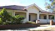
cnr Hensman Rd & Heytesbury Rd Subiaco
Address includes: 144 Heytesbury Rd, Subiaco & 91 Hensman Rd, Subiaco.
Brenda Cherry Centre (1981-2009)
Kensington Hospital, Subiaco
Subiaco
Metropolitan
Constructed from 1936, Constructed from 1922
| Type | Status | Date | Documents |
|---|---|---|---|
| Heritage List | Adopted | 22 Mar 2011 | |
| Heritage Agreement | YES | 06 Nov 2012 | HCWebsite.Listing+ListingDocument |
| Heritage Agreement | YES | 06 Nov 2012 | HCWebsite.Listing+ListingDocument |
| State Register | Registered | 24 Jun 2011 | HCWebsite.Listing+ListingDocument, HCWebsite.Listing+ListingDocument |
| Type | Status | Date | Documents |
|---|---|---|---|
| (no listings) |
| Type | Status | Date | Grading/Management | |
|---|---|---|---|---|
| Category | ||||
| Municipal Inventory | Adopted | 22 Mar 2011 | Exceptional Significance (Level 1) | |
| Municipal Inventory | Adopted | 28 Feb 1995 | ||
Kensington Hospital (fmr) is in fair to good condition as a result of continued occupancy, maintenance and care. There are no particular issues of concern. The sleep-out and other section of the former dwelling at the rear between the dwelling and the 1938 masonry addition are constructed of fibrous cement panels that are likely to contain asbestos.
| Library Id | Title | Medium | Year Of Publication |
|---|---|---|---|
| 9982 | Kensington Hospital(fmr) 89 - 91 Hensman Road, Subiaco | Heritage Study {Cons'n Plan} | 2011 |
Individual Building or Group
| Epoch | General | Specific |
|---|---|---|
| Original Use | RESIDENTIAL | Single storey residence |
| Original Use | HEALTH | Hospital |
| Present Use | HEALTH | Other |
| Style |
|---|
| Inter-War California Bungalow |
| Federation Bungalow |
| Type | General | Specific |
|---|---|---|
| Wall | BRICK | Common Brick |
| Roof | TILE | Terracotta Tile |
| General | Specific |
|---|---|
| OUTSIDE INFLUENCES | Depression & boom |
| OTHER | Other Sub-Theme |
| SOCIAL & CIVIC ACTIVITIES | Community services & utilities |
| DEMOGRAPHIC SETTLEMENT & MOBILITY | Immigration, emigration & refugees |
This information is provided voluntarily as a public service. The information provided is made available in good faith and is derived from sources believed to be reliable and accurate. However, the information is provided solely on the basis that readers will be responsible for making their own assessment of the matters discussed herein and are advised to verify all relevant representations, statements and information.
The place has aesthetic significance because it contributes to the heritage integrity of the streetscape in terms of building style and uniformity, and reflects the architectural style typical of the area and period. It has historic significance reflecting the development and settlement of the area.
The area of West Subiaco developed primarily as residential from the early 1900s. Most of the main roads were gazetted by 1883, but were unsealed until the 1900s. Derby Road was named after Lord Derby, Secretary for Colonies. Hensman Road was named after Mr A P Hensman, Judge and Attorney General. The first houses were established in streets closest to the commercial area along Hay Street and Rokeby Road, and the area west of the civic square, including Barker, Bagot, Hensman, Douglas, Lawler, Loretto, Raphael, Denis and Rowland Streets. Another early subdivision was located along Rokeby Road, and included Rawson, Campbell, Coolgardie, Duke, and Union Streets. Most of the West Subiaco precinct was developed by 1915, with the most recent houses to be built by c1925 in the south west corner. Two land releases, called Redfern Estates No. 1 and No. 2, were situated along the railway line opposite the new suburb of Daglish. Early public buildings in the West Subiaco precinct included the Industrial School on Barker Road (1897), later converted into King Edward Memorial Hospital in 1916. (Sources: Wise's Post Office Directory 1905-1925; Real Estate Maps, Battye Library Collection; Spillman, Ken, Identity Prized: A History of Subiaco, City of Subiaco, UWA Press, 1985; Chate, A, H., History of Subiaco, c1952.)
This information is provided voluntarily as a public service. The information provided is made available in good faith and is derived from sources believed to be reliable and accurate. However, the information is provided solely on the basis that readers will be responsible for making their own assessment of the matters discussed herein and are advised to verify all relevant representations, statements and information.
Railway Pde Subiaco
Subiaco
Metropolitan
Constructed from 1897 to 1997
| Type | Status | Date | Documents |
|---|---|---|---|
| State Register | Registered | 15 May 1998 | HCWebsite.Listing+ListingDocument, HCWebsite.Listing+ListingDocument |
| Type | Status | Date | Documents |
|---|---|---|---|
| (no listings) |
| Type | Status | Date | Grading/Management | |
|---|---|---|---|---|
| Category | ||||
| Statewide Lge Timber Str Survey | Completed | 11 Dec 1998 | ||
| Classified by the National Trust | Classified | 07 Aug 1995 | ||
| Statewide Railway Heritage Surve | Completed | 01 Mar 1994 | ||
| Library Id | Title | Medium | Year Of Publication |
|---|---|---|---|
| 5789 | Timber railway footbridges : interpretation strategy. | Heritage Study {Other} | 2002 |
| 5433 | West Leederville railway footbridge : structural engineering assessment. | Report | 2002 |
Historic site
| Epoch | General | Specific |
|---|---|---|
| Present Use | Transport\Communications | Rail: Other |
| Original Use | Transport\Communications | Rail: Other |
| Style |
|---|
| Other Style |
| Type | General | Specific |
|---|---|---|
| Other | TIMBER | Other Timber |
| General | Specific |
|---|---|
| SOCIAL & CIVIC ACTIVITIES | Sport, recreation & entertainment |
| DEMOGRAPHIC SETTLEMENT & MOBILITY | Settlements |
| TRANSPORT & COMMUNICATIONS | Rail & light rail transport |
This information is provided voluntarily as a public service. The information provided is made available in good faith and is derived from sources believed to be reliable and accurate. However, the information is provided solely on the basis that readers will be responsible for making their own assessment of the matters discussed herein and are advised to verify all relevant representations, statements and information.