Local Government
Mundaring
Region
Metropolitan
Mundaring
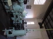
P25251 Goldfields Water Supply Scheme is part of this place and is on the National Heritage List. Starts in Mundaring, at Mundaring Weir and travels through the Shires of Mundaring, Northam, Cunderdin, Tammin, Kellerberrin, Merredin, Westonia, Yilgarn, Coolgardie and Kalgoorlie-Boulder.
Golden Pipeline
Mundaring
Metropolitan
Constructed from 1898
| Type | Status | Date | Documents |
|---|---|---|---|
| State Register | Registered | 08 Dec 2022 | HCWebsite.Listing+ListingDocument, HCWebsite.Listing+ListingDocument |
| Type | Status | Date | Documents |
|---|---|---|---|
| (no listings) |
| Type | Status | Date | Grading/Management | |
|---|---|---|---|---|
| Category | ||||
| (no listings) | ||||
25251 Goldfields Water Supply Scheme (NHL)
• The place is an excellent example of an initiative by the Western Australian Government to provide water to the Goldfields at the turn of the century.
• The place is rare as one of the largest pipelines in Western Australia, possibly the largest that supplies water.
• The place has aesthetic value as a landmark feature extending from Mundaring to Kalgoorlie.
• The place is rare and has scientific value as an innovative engineering design and construction method of a pipeline from the early 20th Century.
• The place is rare as a long-distance water pipeline in Australia built in the early 1900’s.
The Goldfields Water Supply Scheme, demonstrates exceptional technical achievement as one of the longest overland pipeline schemes attempted in the nineteenth century, both in Australia and the world, and was recognised as an outstanding engineering achievement; The has exceptional value in demonstrating the historical importance of the provision of water to settlements along the route from Mundaring to the Eastern Goldfields, The construction and operation of the Pipeline had considerable importance in contributing to the sense of place for the people of Western Australia, and visitors to the State, as a highly valued tourist destination, the educational, cultural and aesthetic aspects of which are appreciated by history and engineering enthusiasts and teachers to this day; Individual elements of the place, including the existing interpretation associated with the Golden Pipeline Heritage Trail, museums, archaeological sites and remaining buildings and infrastructure, collectively have exceptional potential to communicate the history of the Goldfields Water Supply Scheme and its importance to Western Australia; The place is associated with a number of notable figures in Western Australian history, including the Scheme's designer CY O'Connor, State and Federal politician Lord John Forrest, the Director of the Public Works Department HW Venn and former Superintendent of Public Works, architect George Temple Poole, who each contributed to the successful completion of the Goldfields Water Supply Scheme; and The place is an exceptional example of applied science, technical excellence and innovative design, reflecting the ongoing ingenuity and innovation demonstrated by the talented and committed engineers employed by the Goldfields Water Supply Branch, Public Works Department and other iterations of the Water Corporation in the provision of water in the State. The longevity of the scheme is associated with innovators Mephan Ferguson, James Couston, engineers Norman Fernie and Reg Keating, and James Mathers.
The Goldfields Water Supply Scheme extends in a discontiguous precinct across the 560km linear water pipeline, commencing at Mundaring Weir (1902, 1951) in the Helena Valley and terminating at Mount Charlotte Reservoir (1902) in Kalgoorlie-Boulder. Comprising six extant original Steam Pump Stations (1902) at Mundaring, Cunderdin, Merredin, Yerbillon, Ghooli and Dedari; the sites of two demolished Steam Pump Stations (1902) at O’Connor and Gilgai; Reservoirs and Tanks at O’Connor, Sawyers Valley, Bakers Hill, West Northam, Cunderdin, Merredin, Yerbillon, Ghooli, Bronti, Gilgai, Koorawawalyee, Dedari, Toorak, and Bullabulling; second generation Electric Pump Station at Merredin , and other community sites, ancillary structures; equipment and machinery, archaeological sites; and discontiguous portions of the main pipeline conduit associated with the construction and operation of the Scheme from 1902 to the present.
Phase I - Construction of the Goldfields Water Supply Scheme (1898 - 1903) Phase II – Problem Solving and Agricultural Expansion (1904 - 1940) Phase III – Comprehensive Water Supply Scheme, Upgrades & Refurbishments (1946 - 2013) Phase IV - Heritage Recognition and The Golden Pipeline (1992 - 2011)
High
Good
| Name | Type | Year From | Year To |
|---|---|---|---|
| Charles Yelverton O'Connor | Architect | 1898 | 1902 |
| Library Id | Title | Medium | Year Of Publication |
|---|---|---|---|
| 6452 | Mundaring Weir Precinct masterplan : final master plan report. | Heritage Study {Other} | 2002 |
| 7358 | Conservation plan for Goldfields Water Supply Scheme. Volume II, place M : No. 8 Pumping Station, Dedari. | Heritage Study {Cons'n Plan} | 1999 |
| 11426 | Goldfields Water Supply Volume III | Heritage Study {Cons'n Plan} | 1999 |
| 4897 | Conservation plan for Karalee Rock Water Catchment (Goldfields Water Supply Scheme - place J). | Heritage Study {Cons'n Plan} | 2000 |
| 7359 | Conservation plan for Goldfields Water Supply Scheme. Volume II, place N : Bullabulling reservoir. | Heritage Study {Cons'n Plan} | 1999 |
| 9248 | Constructing Australia: Triumphs and tragedies in building a nation. | C D Rom | 2007 |
| 6390 | Pipe-dream to pipeline : the eventful life of Nathaniel W. Harper. | Book | 2001 |
| 3680 | Conservation plan for No. 3 Pumping Station, Cunderdin. | Heritage Study {Cons'n Plan} | 1998 |
| 1774 | An exploratory bibliography of the Goldfields Water Supply of Western Australia (draft). | Report | 1982 |
| 4504 | Conservation plan for Mount Charlotte Reservoir (Goldfields water supply scheme - place O). | Heritage Study {Cons'n Plan} | 2000 |
| 11762 | Goldfields Water Supply Scheme, Main conduit, Western Australia | Heritage Study {Cons'n Plan} | 2016 |
| 6788 | Conservation plan for Koorarawalyee water catchment and railway station (Draft) (Goldfields Water Supply Scheme - place U). | Heritage Study {Cons'n Plan} | 2001 |
| 9806 | Mundaring Weir water Supply interpretation precinct design. | Book | 2010 |
| 7350 | Conservation plan for West Northam regulating tanks : (Goldfields Water Supply Scheme - place T) (draft). | Heritage Study {Cons'n Plan} | 2001 |
| 7356 | Conservation plan for Goldfields Water Supply Scheme. Volume II, place I : No. 6 Pumping Station, Ghooli. | Heritage Study {Cons'n Plan} | 1999 |
| 7547 | Celebrating 100 years of the Goldfields Water Supply Scheme. | Brochure | 2003 |
| 7354 | Conservation plan for Goldfields Water Supply Scheme. Volume II, place G : No. 4 Pumping Station, Merredin. | Heritage Study {Cons'n Plan} | 1999 |
| 7351 | Conservation plan for Toorak Hill reservoir : (Goldfields Water Supply Scheme - place V) (draft). | Heritage Study {Cons'n Plan} | 2001 |
| 7352 | Conservation plan for Goldfields Water Supply Scheme. Volume II, place A : No. 1 Pumping Station Mundaring. | Heritage Study {Cons'n Plan} | 1999 |
| 7348 | Conservation plan for Sawyers Valley summit tanks : (Goldfields Water Supply Scheme - place R) (draft). | Heritage Study {Cons'n Plan} | 2001 |
| 6675 | Mundaring Weir : conservation plan (draft). | Heritage Study {Cons'n Plan} | 2000 |
| 1608 | Conservation and interpretation plan for No.1 Pumping Station Mundaring. | Heritage Study {Cons'n Plan} | 1996 |
| 5988 | Centenary of the Goldfields Water Supply Scheme 1903-2003. | Brochure | 2003 |
| 7444 | The agricultural areas, Great Southern towns and Goldfields Water Supply Scheme : souvenir to commemorate the completion of the project. | Book | 1961 |
| 10170 | The origins of the Eastern Goldfields water scheme in Western Australia: an exercise in the interpretation of historical evidence. | Book | 1954 |
| 4644 | Conservation plan for Goldfields Water Supply Scheme : volume 1. | Heritage Study {Cons'n Plan} | 1999 |
| 7357 | Conservation plan for Goldfields Water Supply Scheme. Volume II, place K : No. 7 Pumping Station, Gilgai. | Heritage Study {Cons'n Plan} | 1999 |
| 8902 | River of steel. A history of the Western Australian Goldfields and Agricultural Water Supply 1903 - 2003. | Book | 2007 |
| 7355 | Conservation plan for Goldfields Water Supply Scheme. Volume II, place H : No. 5 Pumping Station, Yerbillon. | Heritage Study {Cons'n Plan} | 1999 |
| 7353 | Conservation plan for Goldfields Water Supply Scheme. Volume II, place B : No. 2 Pumping Station, O'Connor. | Heritage Study {Cons'n Plan} | 1999 |
| 7349 | Conservation plan for Bakers Hill regulating tank : (Goldfields Water Supply Scheme - place S) (draft). | Heritage Study {Cons'n Plan} | 2001 |
| 6794 | Conservation plan for Bullabulling township and railway catchment. (draft) : a supplement to the Bullabulling Reservoir conservation plan (Goldfields Water Supply Scheme - place N). | Heritage Study {Cons'n Plan} | 2001 |
| 9899 | Mundaring Weir water supply improvement project: heritage management strategy. | Heritage Study {Other} | 2011 |
| 6326 | The golden pipeline heritage trail guide : a time capsule of water, gold and Western Australia. | Book | 2002 |
| 4693 | Goldfields Water Supply heritage project. | Book | 1999 |
| 5544 | Golden Pipeline interpretation plan. | Heritage Study {Other} | 2001 |
Other Built Type
| Epoch | General | Specific |
|---|---|---|
| Original Use | GOVERNMENTAL | Power Station |
| Present Use | GOVERNMENTAL | Pumping Station |
| Present Use | EDUCATIONAL | Museum |
| Style |
|---|
| Vernacular |
| Type | General | Specific |
|---|---|---|
| Wall | BRICK | Common Brick |
| Wall | METAL | Steel |
| Roof | METAL | Corrugated Iron |
| General | Specific |
|---|---|
| SOCIAL & CIVIC ACTIVITIES | Community services & utilities |
| DEMOGRAPHIC SETTLEMENT & MOBILITY | Technology & technological change |
| DEMOGRAPHIC SETTLEMENT & MOBILITY | Resource exploitation & depletion |
| DEMOGRAPHIC SETTLEMENT & MOBILITY | Exploration & surveying |
This information is provided voluntarily as a public service. The information provided is made available in good faith and is derived from sources believed to be reliable and accurate. However, the information is provided solely on the basis that readers will be responsible for making their own assessment of the matters discussed herein and are advised to verify all relevant representations, statements and information.
Northampton to Ravensthorpe
Goes thro following LGAs: Northampton, Yalgoo, Perenjori, Dalwallinu, Wongan-Ballidu, Koorda, Dowerin, Cunderdin, Tammin, Quairading, Corrigin, Wickepin, Kulin, Dumbleyung, Kent, Gnowangerup, Jerramungup, Ravensthorpe. Almost parallel with No 1 Fence, 100 km or so further west.
Emu Barrier Fence
Corrigin
Wheatbelt
Constructed from 1906 to 1908
| Type | Status | Date | Documents |
|---|---|---|---|
| (no listings) |
| Type | Status | Date | Documents |
|---|---|---|---|
| RHP - Does not warrant assessment | Current | 25 Nov 2005 |
| Type | Status | Date | Grading/Management | |
|---|---|---|---|---|
| Category | ||||
| Municipal Inventory | Adopted | 17 Oct 2002 | Category D | |
Good - although it varies along the route
Other Built Type
| Epoch | General | Specific |
|---|---|---|
| Original Use | GOVERNMENTAL | Other |
| Present Use | GOVERNMENTAL | Other |
| Type | General | Specific |
|---|---|---|
| Other | METAL | Other Metal |
| General | Specific |
|---|---|
| OCCUPATIONS | Rural industry & market gardening |
| SOCIAL & CIVIC ACTIVITIES | Government & politics |
This information is provided voluntarily as a public service. The information provided is made available in good faith and is derived from sources believed to be reliable and accurate. However, the information is provided solely on the basis that readers will be responsible for making their own assessment of the matters discussed herein and are advised to verify all relevant representations, statements and information.
Constructed from 1907
The Rabbit Proof Fence has historic and representative cultural heritage significance. The Fence was a major attempt by the WA Government to prevent the pestilence of rabbits, an introduced animal to Australia. The Rabbit Proof Fence No.2 divides the Shire of Dumbleyung and has had a marked influence on the history of land development in the region. Names of roads in the district east of Dumbleyung reflect the effect of the Fence with Fence Rd and 125 Gate Rd being two examples. The fence, though extremely long and crossing many Local Government Areas throughout WA, had a particularly strong influence over land development patterns in Dumbleyung and is representative of early government attempts to help sustain agriculture.
In the late 19th century rabbits which were not established in WA, were recognised as a possible menace to agriculture. The rabbits were travelling from the eastern seaboard at a rate of 35 miles a year and the Western Australian Government formed a plan to try and prevent the pests entry. A decision was made to construct a rabbit proof fence from the 80 Mile Beach in the north, through the Great Sandy Desert to end at Starvation Beach near Esperance in the south. When Rabbit Proof Fence Number One was completed in 1903, it was the longest unbroken line of fence in the world. However, on its completion rabbits had already appeared west of the barrier. Another fence was therefore hurriedly erected roughly 60 miles parallel inside the first. It was built in the period between March and July 1904. The fence was constructed of jam posts placed 12 feet apart with wire netting of which the lowest 6 inches were dipped in coal tar and buried (towards the east) to prevent the rabbits from digging under. A wide clearing either side provided for a fire break and access for boundary riders. The second fence built divided the Dumbleyung district. The fence was kept in order by Government employees. Riders were employed to check the fence, using bicycles for transport. Gates in the fence needed to be opened and closed each time and location was often determined by the gate number (eg. 125 Gate Rd). The many gates made collection of water difficult for some farmers who had to travel many miles to a water supply. The first rabbit proof fence was abandoned in 1916 when it was obvious it had failed and that more time was needed maintaining the second fence. By the 1940s it was realised that the rabbit proof fence had failed but the gates were still patrolled and fines were issued if left open. This vigilance was maintained into the 1950s In 1959 the Rabbit Proof Fence Department was finally disbanded and the gates were left permanently open. At the same time myxomatosis was introduced which greatly reduced the rabbit population. Today the rabbit proof fence is still referred to as 'the fence'. Though no longer a physical divide, people still talk in terms of their community being east or west of the fence.
| Ref ID No | Ref Name | Ref Source | Ref Date |
|---|---|---|---|
| J Timperley; "Beyond the Fence: A History of Kukerin, Moluyinning and Nearby Communities". | 1996 | ||
| O'Brien Planning Consultants; "Municipal Heritage Inventory". | Shire of Dumbleyung | 1998 |
This information is provided voluntarily as a public service. The information provided is made available in good faith and is derived from sources believed to be reliable and accurate. However, the information is provided solely on the basis that readers will be responsible for making their own assessment of the matters discussed herein and are advised to verify all relevant representations, statements and information.
Tammin
Tammin
Wheatbelt
| Type | Status | Date | Documents |
|---|---|---|---|
| (no listings) |
| Type | Status | Date | Documents |
|---|---|---|---|
| (no listings) |
| Type | Status | Date | Grading/Management | |
|---|---|---|---|---|
| Category | ||||
| (no listings) | ||||
Historic site
This information is provided voluntarily as a public service. The information provided is made available in good faith and is derived from sources believed to be reliable and accurate. However, the information is provided solely on the basis that readers will be responsible for making their own assessment of the matters discussed herein and are advised to verify all relevant representations, statements and information.
Cnr Booth & Donnan Sts Tammin
Tammin
Wheatbelt
Constructed from 1935, Constructed from 1926
| Type | Status | Date | Documents |
|---|---|---|---|
| (no listings) |
| Type | Status | Date | Documents |
|---|---|---|---|
| RHP - To be assessed | Current | 29 Oct 2004 |
| Type | Status | Date | Grading/Management | |
|---|---|---|---|---|
| Category | ||||
| (no listings) | ||||
The place is a good example of a public buildings precinct in the Wheatbelt.
The place is associated with the development of Tammin.
The place is significant for its social events and functions provided to the residents of Tammin
The place is associated with the War effort for both World War One and World War Two.
Bank Single storey brick building, with quoins, arched windows, symmetrical façade. Flagpole above entrance.’ Post Office Semi circular opening, single storey, decorative keystone in the central front archway. CWA Hipped roof, single storey, eaves over verandah with brick pillars supporting the verandah. Two chimneys and a Tiled roof.
‘The first settlers took up land in the district in 1893, with the promise of the railway through the region in the near future. The railway from Perth to Southern Cross was opened in 1894, passing through Tammin. In 1894 the Meckering Road Board was gazetted, covering the area of Tammin and Kellerberrin.’ ‘By 1897 there were nine homesteads in Meckering and one in Tammin. Although by 1898 when the Government put down seventeen unsuccessful trial bores in Tammin, there were seven producing farms.’ ‘Tammin Townsite was gazetted on `26th May 1899. By 1900 there were enough settlers and railway workers in the area to warrant the opening of the first school. Wesleyan church services were held under a tree south of the railway line, and cricket was played at the same site. Men working on the Kalgoorlie water pipeline lived in Tammin from 1901, even though the pipeline didn’t open until 1903. The first store in Tammin was established south of the line, by E.D Ryan in 1902 and shortly afterwards another store opened north of the line.’ ‘In January 1903 the Tammin Progress Committee was formed, comprising 13 members under the chairmanship of John Packham.’ ‘During 1906 and 1907 Sir james Mitchell started a settlement scheme for unemployed people at Workarine, north of Tammin. Yporkarine had previously been a pastoral lease by the Clarksons of Toodyay.’ ‘By 1910 the town was developing with the construction of the National Bank, the Post Office, the Tammin Hotel, the Agricultural Hall, a butchers shop, bakers, and the general store changed hands. In 1910 the Progress Committee also put down tennis courts and a cricket pitch at the recreation reserve.’ ‘Wheat, Wool and Wodjil’ Tammin Local History states: ‘Tammin CWA branch was formed on April 18th 1939 by Mrs mary Adamson, president of Western Division. During the war years, 1939-1945 the CWA members worked hard raising funds and sewing clothing for the war effort.’ ‘In 1941, the Younger Set was formed and raised money mainly for the War Effort. The Air Force band stationed at Cunderdin supplied music for 10 pounds and the attendance was 2/- for the weekly dances.’ ‘Members could see the advantages of owning their own Restroom and in 1944 efforts were made to procure a suitable block in the Town. After much debate the block where our building now stands was bought and the adjoining block was donated by Mr F Lardi. The plans were drawn by architect M. Marshal Clifton and Mr Charlie Budd, a local builder took the contract to build the restroom. Eventually on the 28th October 1953, the Rest room was officially opened by Lady McLarty, State President of CWA, Mrs Les Carter Tammin CWA President.’
High
Good
Precinct or Streetscape
| Epoch | General | Specific |
|---|---|---|
| Original Use | PARK\RESERVE | Park\Reserve |
| Original Use | GOVERNMENTAL | Town, Shire or District Hall |
| Original Use | GOVERNMENTAL | Fire Station |
| Present Use | GOVERNMENTAL | Town, Shire or District Hall |
| Present Use | GOVERNMENTAL | Fire Station |
| Present Use | PARK\RESERVE | Park\Reserve |
| Style |
|---|
| Inter-War Stripped Classical |
| Inter-War Art Deco |
| Type | General | Specific |
|---|---|---|
| Roof | METAL | Corrugated Iron |
| Wall | BRICK | Rendered Brick |
| Wall | BRICK | Common Brick |
| General | Specific |
|---|---|
| SOCIAL & CIVIC ACTIVITIES | Religion |
| SOCIAL & CIVIC ACTIVITIES | Government & politics |
| DEMOGRAPHIC SETTLEMENT & MOBILITY | Settlements |
This information is provided voluntarily as a public service. The information provided is made available in good faith and is derived from sources believed to be reliable and accurate. However, the information is provided solely on the basis that readers will be responsible for making their own assessment of the matters discussed herein and are advised to verify all relevant representations, statements and information.

Donnan St Tammin
Tammin
Wheatbelt
Constructed from 1960
| Type | Status | Date | Documents |
|---|---|---|---|
| (no listings) |
| Type | Status | Date | Documents |
|---|---|---|---|
| RHP - To be assessed | Current | 29 Oct 2004 |
| Type | Status | Date | Grading/Management | |
|---|---|---|---|---|
| Category | ||||
| Art Deco Significant Bldg Survey | Completed | 30 Jun 1994 | ||
| Statewide War Memorial Survey | Completed | 01 May 1996 | ||
12211 Tammin Civic Precinct
The place is a rare and good example of a War Memorial and Garden in a rural setting.
The place has associations with World War II and the Vietnam War.
The place has social value as a place of remembrance.
The place social significances for the relations to those who their lives in World War II and Vietnam.
□ Small, grassed park is delineated by the four red brick piers and wrought iron gates. Each pier has a commemorative plaque, for example either World War II, Vietnam or 50 years since World War II. □ The park has two rows of pepper trees and other irregular plantings and picnic settings.
‘The first War Memorial erected in Western Australia was associated with the Boer War In Southern Africa from 1899 to 1902, commonly known as the Boer War. ‘ ‘It was during the interwar years however that the traditions of memorialisation were firmly established and war memorials of various kinds first appeared as significant features in the open landscapes of the suburbs and towns throughout the state. Most communities erected a War memorial and many erected more than one, particularly in country centres where much needed facilities such as community halls and hospitals were erected as memorials in addition to the traditional stone monuments and Honour boards.’
High
Good - well maintained
Urban Park
| Epoch | General | Specific |
|---|---|---|
| Present Use | MONUMENT\CEMETERY | Monument |
| Original Use | MONUMENT\CEMETERY | Monument |
| Type | General | Specific |
|---|---|---|
| Other | BRICK | Other Brick |
| Other | METAL | Other Metal |
| General | Specific |
|---|---|
| OUTSIDE INFLUENCES | World Wars & other wars |
This information is provided voluntarily as a public service. The information provided is made available in good faith and is derived from sources believed to be reliable and accurate. However, the information is provided solely on the basis that readers will be responsible for making their own assessment of the matters discussed herein and are advised to verify all relevant representations, statements and information.

1 Donnan St Tammin
PO Box 53, Tammin 6409
Tammin District Hall
Tammin
Wheatbelt
Constructed from 1920 to 1930
| Type | Status | Date | Documents |
|---|---|---|---|
| (no listings) |
| Type | Status | Date | Documents |
|---|---|---|---|
| RHP - To be assessed | Current | 29 Oct 2004 |
| Type | Status | Date | Grading/Management | |
|---|---|---|---|---|
| Category | ||||
| Municipal Inventory | Completed\Draft | 01 Jul 2014 | Category 1 | |
| Classified by the National Trust | Classified | 08 Feb 1999 | ||
| Statewide War Memorial Survey | Completed | 01 May 1996 | ||
12211 Tammin Civic Precinct
The place contributes to the streetscape and townscape of Tammin.
The Town Hall is a fine example of regional work of Architect Herbert Parry
The Town Hall is associated with the Tammin people since 1910.
The place is associated with the development and growth of Tammin.
Town Hall The building is well proportioned and before the front extension on the east side presented a classical symmetrical frontage to the street. The Tammin Hall shows the most influences as described in the broad characteristics of the Interwar Stripped Classical architectural style; a symmetrical façade, vestigial classical base, and classical portico.’
Town Hall The first moves for the Tammin Town Hall took place in 1903. Events up until that time were held in the Kellerberrin Town Hall. In 9108 a committee was formed to collect the necessary funds to build the hall. They proposed to build the hall on the eastern railway. The hall was built at a cost of 850 pounds.
Integrity- Moderate Authenticity- High
Good
| Library Id | Title | Medium | Year Of Publication |
|---|---|---|---|
| 5383 | Tammin Town Hall : conservation works final report. | Conservation works report | 2001 |
| 3688 | Tammin Town Hall Conservation Plan | Heritage Study {Cons'n Plan} | 1998 |
Individual Building or Group
| Epoch | General | Specific |
|---|---|---|
| Original Use | MONUMENT\CEMETERY | Monument |
| Original Use | GOVERNMENTAL | Town, Shire or District Hall |
| Present Use | GOVERNMENTAL | Town, Shire or District Hall |
| Style |
|---|
| Inter-War Stripped Classical |
| Type | General | Specific |
|---|---|---|
| Roof | METAL | Corrugated Iron |
| Wall | BRICK | Other Brick |
| General | Specific |
|---|---|
| OUTSIDE INFLUENCES | World Wars & other wars |
This information is provided voluntarily as a public service. The information provided is made available in good faith and is derived from sources believed to be reliable and accurate. However, the information is provided solely on the basis that readers will be responsible for making their own assessment of the matters discussed herein and are advised to verify all relevant representations, statements and information.
Constructed from 1911 to 1968
The Hall represents periods of historical development in the townsite and district depicting changes that have taken place since the early 1900’s. The building represents a fine regional example of architectural work of its type and period in the period.
The Building is well proportioned and before the front extension on the east side, presented a classical symmetrical frontage to the street. The Tammin Hall shows the most influences as described in the broad characteristics of the “Inter War Stripped Classical c1915 – c1940” style of architecture. The building comprises several periods of development. The four sections of the building link together internally and although they form one building, each section has different exterior treatments.
Community Hall – The first moves for a community hall in Tammin took place in 1903. In 1908 a public meeting was convened by the Tammin Progress Association to form a committee to collect funding. The Hall was built at a cost of 850 pounds and officially opened on 16th June 1911. The Hall quickly became the social centre for the Tammin community. In 1930 a bio box was installed in the Hall and permission granted for the showing of pictures which continued for several years. Church services of various denominations were conducted in the Hall until the mid 1930’s when the Anglican Church was opened. In 1940 extensions to the front and side of the Hall designed by Herbert Parry were built by Braidwood. The extensions included front rooms to the east for a library and to the west a meeting and ladies cloak room. The Lessor Hall was also built at that time and the rear kitchen extended to access the main hall and lessor hall. Ballroom dancing was a significant social event for the hall during the 1940’s and early 1950’s. Due to a severe storm in 1953, the hall was extensively renovated and further extensions added in 1955. In 1968 a further room was added to the front of the hall and the kitchen extended. The hall continues to provide a vital public venue for the community of the Tammin district.
Integrity: Intact or redeemable Authenticity: High degree
Good
| Name | Type | Year From | Year To |
|---|---|---|---|
| Parry & Rosenthal | Architect | - | - |
| Ref ID No | Ref Name | Ref Source | Ref Date |
|---|---|---|---|
| Laura Gray | Conservation Plan |
| Reserve | Lot/Location | Plan/Diagram | Vol/Folio |
|---|---|---|---|
| 26973 | Lot 154 |
This information is provided voluntarily as a public service. The information provided is made available in good faith and is derived from sources believed to be reliable and accurate. However, the information is provided solely on the basis that readers will be responsible for making their own assessment of the matters discussed herein and are advised to verify all relevant representations, statements and information.

5 Donnan St Tammin
Cnr Booth St
Tammin
Wheatbelt
Constructed from 1926, Constructed from 1935
| Type | Status | Date | Documents |
|---|---|---|---|
| (no listings) |
| Type | Status | Date | Documents |
|---|---|---|---|
| RHP - To be assessed | Current | 29 Oct 2004 |
| Type | Status | Date | Grading/Management | |
|---|---|---|---|---|
| Category | ||||
| Fire & Rescue Service Heritage Inventory | Adopted | 30 Aug 1997 | ||
12211 Tammin Civic Precinct
The 1926 building is the only confirmed extant example of a modest fire station built during the WAFBB consolidation in the 1920s. It contrasts with the more substantial stations built at North Perth, Leederville, Northam and Wagin at this time.
The 1935 building is a good example of the design and use of single bay station with brick facades and central raised parapets as one of the standard building types for fire stations in the 1930s. It is one of three stations of this type which have retained a high degree of authenticity and continues to be used for the original purpose (Guildford and North Kalgoorlie).
Tammin Fire Station (1935) makes a positive contribution to the townscape.
Current fire station (1935) with former fire station (1926) to the rear. The former fire station is a single roomed timber frame corrugated iron structure, with double corrugated iron doors at one end, a small window on one side and a gabled roof. The 1935 building is single storey with brick façade with a stepped rendered parapet and door surround. The remainder of the building is clad with vertical corrugated iron. Gable roof with a skillion at the rear and steel framed belltower with bell. Roller door front entry.
The Meckering Road District was proclaimed a Fire District c. 1926, with the area being restricted to the town of Tammin. Volunteers built a fire station in 1926. The WA Fire Brigade Board instituted an extensive building campaign in the early C20, with 54 new fire stations built between 1909 and 1929. While some were architecturally designed (such as Northam, Midland, Wagin) the majority were modest structures built by volunteers. A new station was completed to the front of the building in 1935. The original fire station was then used for storage and is still used for this purpose. During 1932, the WAFBB requested that architect K C Duncan draw up a standard plan for country fire stations. Eighteen new stations were built between 1933 and 1938, 15 of which were in country towns. Tammin was one of 5 single bay stations with brick facades and a central raised parapet (Guildford, Kalgoorlie North, Busselton, Meekatharra). Other types included corrugated iron, single bay stations with rendered facades and stations with a single appliance bay and flanking accommodation/office wings.
High
Good
| Name | Type | Year From | Year To |
|---|---|---|---|
| K C Duncan | Architect | - | - |
Individual Building or Group
| Epoch | General | Specific |
|---|---|---|
| Original Use | GOVERNMENTAL | Fire Station |
| Present Use | GOVERNMENTAL | Fire Station |
| Present Use | GOVERNMENTAL | Office or Administration Bldg |
| Style |
|---|
| Inter-War Art Deco |
| Type | General | Specific |
|---|---|---|
| Wall | METAL | Corrugated Iron |
| Wall | BRICK | Rendered Brick |
| Roof | METAL | Corrugated Iron |
| General | Specific |
|---|---|
| SOCIAL & CIVIC ACTIVITIES | Community services & utilities |
This information is provided voluntarily as a public service. The information provided is made available in good faith and is derived from sources believed to be reliable and accurate. However, the information is provided solely on the basis that readers will be responsible for making their own assessment of the matters discussed herein and are advised to verify all relevant representations, statements and information.

Cnr Dreyer & Mclaren St Tammin
Tammin
Wheatbelt
Constructed from 1932
| Type | Status | Date | Documents |
|---|---|---|---|
| (no listings) |
| Type | Status | Date | Documents |
|---|---|---|---|
| RHP - To be assessed | Current | 29 Oct 2004 |
| Type | Status | Date | Grading/Management | |
|---|---|---|---|---|
| Category | ||||
| Municipal Inventory | Completed\Draft | 01 Jul 2014 | Category 3 | |
| Anglican Church Inventory | YES | 31 Jul 1996 | ||
The place has aesthetic value for its distinctive architectural style, streetscape and townscape.
The place has historic value as it was the first church in Tammin.
The place is rare as an Interwar Romanesque Church in Western Australia.
The place has social value as it is valued by the local Anglican community for their associations with cultural and spiritual events.
The Conservation Plan for St Mark’s Anglican Church states: ‘St Mark’s Anglican Church is a one storey brick structure with a medium pitched corrugated iron roof. It is essentially a rural vernacular building responding to the practicalities of the function, the economics of the parish and availability of materials. It displays some influences of Interwar Romanesque architectural style.’ ‘The characteristics of the style as demonstrated in St Mark’s Church include the strong clearly expressed shape, strong emphasis on the wall as a massive load bearing envelope, restrained ornamentation in key with the overall massing, rugged rather than elegant character, round headed arches, buttresses and trussed roof construction with roof timbers not exposed.’
The Conservation Plan for St Marks Anglican Church states: ‘At a meeting on 10 March 1933, the decision was made to build the church, and the services of local Tammin builder Charles Budd were subsequently obtained. On 14th August 1932, John Packhan senior laid the foundation stone with a silver trowel.’ ‘On 26th March 1933, St Marks was consecrated by Archbishop LeFanu, assisted by Mr Deanna Hammond. A congregation of over 150 people witnessed the consecration which included the ancient custom of the Archbishop knocking three times at the west door (front) of the church and being admitted by the church Wardens, Reg Withers and Tom Packham, who petitioned him to consecrate the building. The Archbishop was both a celebrant and preacher at the Eucharist that followed the consecration.’ ‘The church was built and furnished at a cost of £750.00. The Tammin church people raised £530.00 over a period of 10-12 years. £100 was borrowed from the church office and together with generous donations of furnishings and voluntary cartage and labour, the cost of the church was covered. ‘ ‘The first baptisms took place on 16th April 1933’ and the ‘first weddings took place on 19th September 1934’.’
Integrity- High Authenticity- Moderate
Good
| Library Id | Title | Medium | Year Of Publication |
|---|---|---|---|
| 5153 | Conservation plan : St Mark's Anglican Church Tammin / prepared for the Tammin congregation in the East Avon Parish by Laura Gray. | Heritage Study {Cons'n Plan} | 2000 |
Individual Building or Group
| Epoch | General | Specific |
|---|---|---|
| Original Use | RELIGIOUS | Church, Cathedral or Chapel |
| Present Use | RELIGIOUS | Church, Cathedral or Chapel |
| Style |
|---|
| Inter-War Romanesque |
| Type | General | Specific |
|---|---|---|
| Wall | BRICK | Common Brick |
| General | Specific |
|---|---|
| SOCIAL & CIVIC ACTIVITIES | Religion |
This information is provided voluntarily as a public service. The information provided is made available in good faith and is derived from sources believed to be reliable and accurate. However, the information is provided solely on the basis that readers will be responsible for making their own assessment of the matters discussed herein and are advised to verify all relevant representations, statements and information.
Constructed from 1932 to 1953
The place represents the history of religious and community development since the early 1930’s. The architecture is a representative example of religious architecture for the period, and contributes to the streetscape of Tammin.
The classical frontage is set back from the front boundary of the site with side entry directly onto the pavement. The Church is red brick and iron construction with rendered brick banding. The front porch is tiled.
Religious – The first Church built in Tammin with the foundation stone being laid by Mr John Packham who was an early pioneer of the district. The Church represents significant development of the Tammin community since its construction in 1932. A committee of towns and district community members formed 12 years previously raised the required funds. Arch Bishop Le Fanu officially consecrated and opened the Church on 26th March 1933. Until the opening of St. Mark’s all church services and functions were conducted in the Shire Town Hall. Various religious denominations utilised St. Mark’s for their own services and functions until the mid 1950’s. St. Mark’s Anglican Church continues to play a prominent role in the community.
Integrity: Intact or redeemable Authenticity: High degree
Good
| Name | Type | Year From | Year To |
|---|---|---|---|
| Charles W. Budd | Architect | - | - |
| Ref ID No | Ref Name | Ref Source | Ref Date |
|---|---|---|---|
| Shire of Tammin Conservation Plan | Laura Gray | October 1998 |
| Ref Number | Description |
|---|---|
| Reference No. 2 |
| Reserve | Lot/Location | Plan/Diagram | Vol/Folio |
|---|---|---|---|
| Lot 10 - Location No 123 |
| Owner | Category |
|---|---|
| Perth Diocesan Trustees | Church Property |
This information is provided voluntarily as a public service. The information provided is made available in good faith and is derived from sources believed to be reliable and accurate. However, the information is provided solely on the basis that readers will be responsible for making their own assessment of the matters discussed herein and are advised to verify all relevant representations, statements and information.
Goldfields Rd Tammin
Tammin
Wheatbelt
Constructed from 1890
| Type | Status | Date | Documents |
|---|---|---|---|
| (no listings) |
| Type | Status | Date | Documents |
|---|---|---|---|
| RHP - To be assessed | Current | 27 Aug 2004 |
| Type | Status | Date | Grading/Management | |
|---|---|---|---|---|
| Category | ||||
| (no listings) | ||||
The place has historical value as it is one of the first rock catchments in W.A.
The place has associations with the establishment of the railway network to the Eastern Goldfields during the gold boom of the 1890s.
The place forms part of system of reservoirs and dams established to provide water for the steam engines that once operated on the railway; a function which is no longer practised.
□ Extensive white rock clay embankment at least 600m in length. □ Evidence of channel at the base of embankment and on the other side of the gravel road. □ No evidence of any rock lining in the channel. □100-200m along the channel formation there is a stone ruin (the caretaker's cottage, see documentary evidence). □ There is one dam located at this site.
In 1887 gold was discovered at Yilgarn and in 1888 the area was proclaimed a goldfield. Arthur Bayley and John Ford discovered gold in 1892 at Fly Flat (now known as Coolgardie). Shortly after this in 1894, Hannan, Flannigan and O’Shea found gold at Kalgoorlie leading to one of the biggest goldrushes in the state's history. This gold boom brought many people from throughout the state and the Eastern States to the Goldfields. The high population and a lack of fresh water due to the low rainfall and a lack of a permanent water source caused serious health and general living problems. A variety of alternative water sources were considered including condensing water, digging bores and carting water, but none were sufficient to meet the needs. This led to Premier Forrest's request to CY O'Connor, Engineer in Chief, to design and construct a water supply scheme to the goldfields. The Goldfields Water Supply Scheme was opened in 1903. The goldrush meant an increase in traffic between Perth and Kalgoorlie. Many walked or rode bicycles to the goldfields, but the increase in population meant supplies, material and water as well as people needed to be transported. The existing railway over the Darling Range was inadequate. CY O'Connor surveyed a route for a new railway line, replacing the one over the Darling Range and continuing on to Kalgoorlie which was opened in 1896. The steam trains used more than half the water they were able to carry and so an alternative water supply was needed. A series of dams and rock catchments were constructed. These utilized naturally formed granite outcrops. Low stone walls were built around the perimeter of the rock (sometimes two adjacent rocks were used). The water captured by the walls was directed into stone lined channels to either one or two dams or reservoirs. In some instances creeks were dammed to provide the water source. The water was pumped from these dams to tanks located beside the railway line. These pumps and the catchments itself were often maintained by a caretaker who lived on site. As places where water was available on the route to the goldfields, small settlements often developed around them. A number of these rock catchments and dams are now used regularly as recreation areas. Two (Karalee and Merredin) are included as sites on the National Trust's Golden Pipeline Heritage Trail. Ann Brake suggested that the channels at the site may have once been used for military trench warfare training.
Integrity- Low Authenticity- Moderate
Poor
Other Built Type
| Epoch | General | Specific |
|---|---|---|
| Original Use | GOVERNMENTAL | Reservoir or Dam |
| Present Use | VACANT\UNUSED | Vacant\Unused |
| Type | General | Specific |
|---|---|---|
| Other | STONE | Other Stone |
| General | Specific |
|---|---|
| OTHER | Other Sub-Theme |
This information is provided voluntarily as a public service. The information provided is made available in good faith and is derived from sources believed to be reliable and accurate. However, the information is provided solely on the basis that readers will be responsible for making their own assessment of the matters discussed herein and are advised to verify all relevant representations, statements and information.
Great Eastern Hwy Tammin
Situated near the western base of a granit rock (Tammin Rock). It's location is signposted on the York - Tammin Road.
Tammin
Wheatbelt
Constructed from 1890 to 1900
| Type | Status | Date | Documents |
|---|---|---|---|
| (no listings) |
| Type | Status | Date | Documents |
|---|---|---|---|
| (no listings) |
| Type | Status | Date | Grading/Management | |
|---|---|---|---|---|
| Category | ||||
| Wells of Explorer Charles Hunt Survey | Recorded | 01 Nov 1991 | ||
Other Built Type
| Epoch | General | Specific |
|---|---|---|
| Original Use | GOVERNMENTAL | Other |
| Type | General | Specific |
|---|---|---|
| Wall | STONE | Granite |
| General | Specific |
|---|---|
| SOCIAL & CIVIC ACTIVITIES | Community services & utilities |
| DEMOGRAPHIC SETTLEMENT & MOBILITY | Settlements |
| DEMOGRAPHIC SETTLEMENT & MOBILITY | Exploration & surveying |
| DEMOGRAPHIC SETTLEMENT & MOBILITY | Aboriginal Occupation |
This information is provided voluntarily as a public service. The information provided is made available in good faith and is derived from sources believed to be reliable and accurate. However, the information is provided solely on the basis that readers will be responsible for making their own assessment of the matters discussed herein and are advised to verify all relevant representations, statements and information.
Cnr Great Eastern Hwy & Station Rd Tammin
Tammin
Wheatbelt
| Type | Status | Date | Documents |
|---|---|---|---|
| (no listings) |
| Type | Status | Date | Documents |
|---|---|---|---|
| (no listings) |
| Type | Status | Date | Grading/Management | |
|---|---|---|---|---|
| Category | ||||
| Municipal Inventory | Completed\Draft | 01 Jul 2014 | Category 4 | |
Individual Building or Group
| Epoch | General | Specific |
|---|---|---|
| Present Use | RESIDENTIAL | Other |
| General | Specific |
|---|---|
| SOCIAL & CIVIC ACTIVITIES | Sport, recreation & entertainment |
| SOCIAL & CIVIC ACTIVITIES | Community services & utilities |
This information is provided voluntarily as a public service. The information provided is made available in good faith and is derived from sources believed to be reliable and accurate. However, the information is provided solely on the basis that readers will be responsible for making their own assessment of the matters discussed herein and are advised to verify all relevant representations, statements and information.
Constructed from 1953
The place represents the history of sporting organisations in the district. The building represents an example of architectural work of its type for the period.
The building is of cement bricks with a cement tiled roof. The central area facing east is open on to a verandah with kitchen and ladies toilet facilities on the north side, drink room, office and men’s toilet facilities on the south side.
Sporting – The building was first built in 1953 and reflects community spirit in the district. Community volunteers recognised the need to develop and enhance tennis activities in the district and combined their resources to construct the building. Decreasing town population and interest in tennis has resulted in the close of the tennis club house.
Authenticity : High to medium degree Integrity : Intact or redeemable
Poor – The building is badly in need of major maintenance and restoration. A great number of cracks appeared in the walls after earth tremors. Until such work is carried out it would probably be unsafe for public use.
| Name | Type | Year From | Year To |
|---|---|---|---|
| P.G. York | Architect | - | - |
| Ref Number | Description |
|---|---|
| Reference No. 4 | Municipal Inventory |
| Reserve | Lot/Location | Plan/Diagram | Vol/Folio |
|---|---|---|---|
| Avon Location 23552 |
| Owner | Category |
|---|---|
| Tammin Shire Council | Local Gov't |
This information is provided voluntarily as a public service. The information provided is made available in good faith and is derived from sources believed to be reliable and accurate. However, the information is provided solely on the basis that readers will be responsible for making their own assessment of the matters discussed herein and are advised to verify all relevant representations, statements and information.
Packham rd Tammin
Tammin
Wheatbelt
| Type | Status | Date | Documents |
|---|---|---|---|
| (no listings) |
| Type | Status | Date | Documents |
|---|---|---|---|
| (no listings) |
| Type | Status | Date | Grading/Management | |
|---|---|---|---|---|
| Category | ||||
| Municipal Inventory | Completed\Draft | 01 Jul 2014 | Category 4 | |
Individual Building or Group
| Epoch | General | Specific |
|---|---|---|
| Present Use | RESIDENTIAL | Single storey residence |
This information is provided voluntarily as a public service. The information provided is made available in good faith and is derived from sources believed to be reliable and accurate. However, the information is provided solely on the basis that readers will be responsible for making their own assessment of the matters discussed herein and are advised to verify all relevant representations, statements and information.
Constructed from 1892 to 1952
The place represents the history of agricultural homesteads in the district. The homestead design is a fine representative example of late 19th century architecture.
This historic homestead was the first built in the Tammin district. The original part of the homestead is built of mud bricks, the additions are of cement brick. At the time of the additions the original corrugated iron roof was removed and replaced with a red cement tile.
Residential – the homestead was first built in the late 19th century and was the first homestead in the district of Tammin to be built. Fourth generation descendants of the original owner and builder (Packham family) occupy the dwelling.
Integrity: Intact or redeemable Authenticity: High degree
Badly in need of major maintenance and restoration
| Name | Type | Year From | Year To |
|---|---|---|---|
| Not known | Architect | - | - |
| Ref ID No | Ref Name | Ref Source | Ref Date |
|---|---|---|---|
| Packham Family book | 100 years at Doongin | ||
| Laura Gray | Tammin Town Hall Conservation Plan | June 1999 |
| Ref Number | Description |
|---|---|
| Reference No. 3 | Municipal Inventory |
| Reserve | Lot/Location | Plan/Diagram | Vol/Folio |
|---|---|---|---|
| Avon Location 457 |
| Owner | Category |
|---|---|
| Doongin Pty Ltd (J.M. Packham) | Other Private |
This information is provided voluntarily as a public service. The information provided is made available in good faith and is derived from sources believed to be reliable and accurate. However, the information is provided solely on the basis that readers will be responsible for making their own assessment of the matters discussed herein and are advised to verify all relevant representations, statements and information.
Lot 17 Shields St Tammin
Tammin
Wheatbelt
Constructed from 1956
| Type | Status | Date | Documents |
|---|---|---|---|
| (no listings) |
| Type | Status | Date | Documents |
|---|---|---|---|
| (no listings) |
| Type | Status | Date | Grading/Management | |
|---|---|---|---|---|
| Category | ||||
| Catholic Church Inventory | Adopted | 01 Jul 1998 | ||
good
| Name | Type | Year From | Year To |
|---|---|---|---|
| Jim Costello | Architect | - | - |
Individual Building or Group
| Epoch | General | Specific |
|---|---|---|
| Present Use | RELIGIOUS | Church, Cathedral or Chapel |
| Original Use | RELIGIOUS | Church, Cathedral or Chapel |
| Style |
|---|
| Post-War Ecclesiastical |
| Type | General | Specific |
|---|---|---|
| Roof | TILE | Ceramic Tile |
| Wall | BRICK | Common Brick |
| General | Specific |
|---|---|
| SOCIAL & CIVIC ACTIVITIES | Religion |
This information is provided voluntarily as a public service. The information provided is made available in good faith and is derived from sources believed to be reliable and accurate. However, the information is provided solely on the basis that readers will be responsible for making their own assessment of the matters discussed herein and are advised to verify all relevant representations, statements and information.

Walston St Tammin
Tammin
Wheatbelt
| Type | Status | Date | Documents |
|---|---|---|---|
| (no listings) |
| Type | Status | Date | Documents |
|---|---|---|---|
| (no listings) |
| Type | Status | Date | Grading/Management | |
|---|---|---|---|---|
| Category | ||||
| (no listings) | ||||
Individual Building or Group
| Epoch | General | Specific |
|---|---|---|
| Original Use | COMMERCIAL | Shop\Retail Store {single} |
| Present Use | COMMERCIAL | Shop\Retail Store {single} |
This information is provided voluntarily as a public service. The information provided is made available in good faith and is derived from sources believed to be reliable and accurate. However, the information is provided solely on the basis that readers will be responsible for making their own assessment of the matters discussed herein and are advised to verify all relevant representations, statements and information.

Walston St Tammin
includes: Tammin Bank Tammin CWA
Tammin
Wheatbelt
Constructed from 1900 to 1940
| Type | Status | Date | Documents |
|---|---|---|---|
| (no listings) |
| Type | Status | Date | Documents |
|---|---|---|---|
| RHP - To be assessed | Current | 29 Oct 2004 |
| Type | Status | Date | Grading/Management | |
|---|---|---|---|---|
| Category | ||||
| (no listings) | ||||
The place is a good example of a public building's precinct in the Wheatbelt.
The place is associated with the development of Tammin.
The place is significant for its social events and functions provided to the residents of Tammin
The place is associated with the War effort for both World War One and World War Two.
Bank Single storey brick building, with quoins, arched windows, symmetrical façade. Flagpole above entrance.’ Post Office Semicircular opening, single storey, decorative keystone in the central front archway. CWA Hipped roof, single storey, eaves over verandah with brick pillars supporting the verandah. Two chimneys and a Tiled roof.
St Marks Anglican Church Conservation Plan states: ‘The first settlers took up land in the district in 1893, with the promise of the railway through the region in the near future. The railway from Perth to Southern Cross was opened in 1894, passing through Tammin. In 1894 the Meckering Road Board was gazetted, covering the area of Tammin and Kellerberrin.’ ‘By 1897 there were nine homesteads in Meckering and one in Tammin. Although by 1898 when the Government put down seventeen unsuccessful trial bores in Tammin, there were seven producing farms.’ ‘Tammin Townsite was gazetted on `26th May 1899. By 1900 there were enough settlers and railway workers in the area to warrant the opening of the first school. Wesleyan church services were held under a tree south of the railway line, and cricket was played at the same site. Men working on the Kalgoorlie water pipeline lived in Tammin from 1901, even though the pipeline didn’t open until 1903. The first store in Tammin was established south of the line, by E.D Ryan in 1902 and shortly afterwards another store opened north of the line.’ ‘In January 1903 the Tammin Progress Committee was formed, comprising 13 members under the chairmanship of John Packham.’ ‘During 1906 and 1907 Sir james Mitchell started a settlement scheme for unemployed people at Workarine, north of Tammin. Yporkarine had previously been a pastoral lease by the Clarksons of Toodyay.’ ‘By 1910 the town was developing with the construction of the National Bank, the Post Office, the Tammin Hotel, the Agricultural Hall, a butcher's shop, bakers, and the general store changed hands. In 1910 the Progress Committee also put down tennis courts and a cricket pitch at the recreation reserve.’ ‘Wheat, Wool and Wodjil’ Tammin Local History states: ‘Tammin CWA branch was formed on April 18th, 1939, by Mrs mary Adamson, president of Western Division. During the war years, 1939-1945 the CWA members worked hard raising funds and sewing clothing for the war effort.’ ‘In 1941, the Younger Set was formed and raised money mainly for the War Effort. The Air Force band stationed at Cunderdin supplied music for 10 pounds and the attendance was 2/- for the weekly dances.’ ‘Members could see the advantages of owning their own Restroom and in 1944 efforts were made to procure a suitable block in the Town. After much debate the block where our building now stands was bought and the adjoining block was donated by Mr F Lardi. The plans were drawn by architect M. Marshal Clifton and Mr Charlie Budd, a local builder took the contract to build the restroom. Eventually on the 28th of October 1953, the Rest room was officially opened by Lady McLarty, State President of CWA, Mrs Les Carter Tammin CWA President.’
High
Good
Individual Building or Group
| Epoch | General | Specific |
|---|---|---|
| Present Use | Transport\Communications | Comms: Post or Telegraph Office |
| Present Use | SOCIAL\RECREATIONAL | CWA Hall |
| Original Use | Transport\Communications | Comms: Post or Telegraph Office |
| Original Use | SOCIAL\RECREATIONAL | CWA Hall |
| Original Use | COMMERCIAL | Bank |
| Present Use | COMMERCIAL | Bank |
| Style |
|---|
| Federation Bungalow |
| Inter-War Free Classical |
| Type | General | Specific |
|---|---|---|
| Wall | BRICK | Other Brick |
| Roof | TILE | Other Tile |
| General | Specific |
|---|---|
| SOCIAL & CIVIC ACTIVITIES | Community services & utilities |
| TRANSPORT & COMMUNICATIONS | Mail services |
| TRANSPORT & COMMUNICATIONS | Telecommunications |
| OCCUPATIONS | Commercial & service industries |
| DEMOGRAPHIC SETTLEMENT & MOBILITY | Settlements |
This information is provided voluntarily as a public service. The information provided is made available in good faith and is derived from sources believed to be reliable and accurate. However, the information is provided solely on the basis that readers will be responsible for making their own assessment of the matters discussed herein and are advised to verify all relevant representations, statements and information.

30 Walston St Tammin
Tammin
Wheatbelt
Constructed from 1930
| Type | Status | Date | Documents |
|---|---|---|---|
| (no listings) |
| Type | Status | Date | Documents |
|---|---|---|---|
| (no listings) |
| Type | Status | Date | Grading/Management | |
|---|---|---|---|---|
| Category | ||||
| Statewide Bank Survey | Completed | 01 Nov 1997 | ||
Individual Building or Group
| Epoch | General | Specific |
|---|---|---|
| Original Use | COMMERCIAL | Bank |
| Present Use | COMMERCIAL | Bank |
| Style |
|---|
| Inter-War Free Classical |
| Type | General | Specific |
|---|---|---|
| Roof | TILE | Ceramic Tile |
| Wall | BRICK | Common Brick |
| General | Specific |
|---|---|
| OCCUPATIONS | Commercial & service industries |
This information is provided voluntarily as a public service. The information provided is made available in good faith and is derived from sources believed to be reliable and accurate. However, the information is provided solely on the basis that readers will be responsible for making their own assessment of the matters discussed herein and are advised to verify all relevant representations, statements and information.
Walston St Tammin
Tammin
Wheatbelt
Constructed from 1958
| Type | Status | Date | Documents |
|---|---|---|---|
| (no listings) |
| Type | Status | Date | Documents |
|---|---|---|---|
| (no listings) |
| Type | Status | Date | Grading/Management | |
|---|---|---|---|---|
| Category | ||||
| Uniting Church Inventory | Completed | 01 Oct 1996 | ||
Individual Building or Group
| Epoch | General | Specific |
|---|---|---|
| Present Use | RELIGIOUS | Church, Cathedral or Chapel |
| Original Use | RELIGIOUS | Church, Cathedral or Chapel |
| Type | General | Specific |
|---|---|---|
| Wall | BRICK | Common Brick |
| Roof | TILE | Ceramic Tile |
| General | Specific |
|---|---|
| SOCIAL & CIVIC ACTIVITIES | Religion |
This information is provided voluntarily as a public service. The information provided is made available in good faith and is derived from sources believed to be reliable and accurate. However, the information is provided solely on the basis that readers will be responsible for making their own assessment of the matters discussed herein and are advised to verify all relevant representations, statements and information.
Various
Contains the main reservoirs: Mundaring Weir (Dam) and Mount Charlotte Reservoir; the main conduit of the pipeline (including all locking bar pipe, wood stave pipe and continuously welded pipe) which stretches 560km from Mundaring in the west to Kalgoorlie in the east; the remaining six of the eight original pump stations (Nos 1, 3, 5, 6, 7 and 8) including remaining equipment; the remaining four associated holding tanks (located at Steam Pump Stations Nos, 2, 4, 7 and 8); and the four regulating tanks located at Bakers Hill, West Northam; Bullabulling and Toorak Hill.
Goldfields Water Supply Scheme (NHL)
Mundaring
Metropolitan
Constructed from 1898
| Type | Status | Date | Documents |
|---|---|---|---|
| National Heritage List | YES | 22 Jun 2011 |
| Type | Status | Date | Documents |
|---|---|---|---|
| (no listings) |
| Type | Status | Date | Grading/Management | |
|---|---|---|---|---|
| Category | ||||
| (no listings) | ||||
The Goldfields Pipeline has exceptional and unique cultural significance for the nation as one of the greatest engineering and infrastructure schemes of the late nineteenth century. It attracted worldwide attention since never before had water been pumped so far nor lifted so high. It was also the first major pipeline in the world to be constructed of steel. The Goldfields Pipeline is highly significant as a key element in the pattern of population, development, economics and resource exploitation in Western Australia and the nation. It has been the lifeline to the Eastern Goldfields gold and nickel mining province which has made an enormous contribution to the prosperity of Western Australia and the nation in turn over the past one hundred plus years. The extension of the scheme has also had a significant impact on the development of the Western Australian wheatbelt.
The pipeline component of the Goldfields Water Supply Scheme stretches 560km from Mundaring to Kalgoorlie. The terrain which the pipeline occupies is not included in the place, rather the extant fabric of the pipeline (including the remaining original steel pipes, the 1930s refurbished continuously welded pipe, 1950s replacements and concrete anchor blocks) constitute the boundary of this element of the Goldfields Water Supply Scheme. The Goldfields Water Supply Scheme is a late 19th century/early 20th century inter-basin transfer water system which extends from Mundaring Weir (Dam) in the west (approximately 41.5 km east of Perth), to Mount Charlotte Reservoir at Kalgoorlie in the east. The Scheme stretches from the Darling Ranges across the arid interior of Western Australia, a total distance of some 560 kilometres. Included are: � the main reservoirs: Mundaring Weir (Dam) and Mount Charlotte Reservoir; the main conduit of the pipeline (including all locking bar pipe, wood stave pipe and continuously welded pipe) which stretches 560km from Mundaring in the west to Kalgoorlie in the east; the remaining six of the eight original pump stations (Nos 1, 3, 5, 6, 7 and 8) including remaining equipment; � the remaining four associated holding tanks (located at Steam Pump Stations Nos, 2, 4, 7 and 8); and the four regulating tanks located at Bakers Hill, West Northam; Bullabulling and Toorak Hill.
| Library Id | Title | Medium | Year Of Publication |
|---|---|---|---|
| 11762 | Goldfields Water Supply Scheme, Main conduit, Western Australia | Heritage Study {Cons'n Plan} | 2016 |
| 11917 | Goldfields Water Supply Scheme : EPBC Act Preliminary documentation including a a response to request for further information. | Heritage Study {Other} | 2021 |
Individual Building or Group
| Epoch | General | Specific |
|---|---|---|
| Original Use | GOVERNMENTAL | Pumping Station |
| Present Use | GOVERNMENTAL | Pumping Station |
| Style |
|---|
| Vernacular |
| Type | General | Specific |
|---|---|---|
| Wall | BRICK | Common Brick |
| Roof | METAL | Steel |
| Wall | METAL | Steel |
| General | Specific |
|---|---|
| DEMOGRAPHIC SETTLEMENT & MOBILITY | Resource exploitation & depletion |
| DEMOGRAPHIC SETTLEMENT & MOBILITY | Exploration & surveying |
| DEMOGRAPHIC SETTLEMENT & MOBILITY | Technology & technological change |
This information is provided voluntarily as a public service. The information provided is made available in good faith and is derived from sources believed to be reliable and accurate. However, the information is provided solely on the basis that readers will be responsible for making their own assessment of the matters discussed herein and are advised to verify all relevant representations, statements and information.