Local Government
Perth
Region
Metropolitan
East & West Perth, Highgate, Northbridge
Perth
Metropolitan
| Type | Status | Date | Documents |
|---|---|---|---|
| State Register | Registered | 11 Sep 2015 | HCWebsite.Listing+ListingDocument, HCWebsite.Listing+ListingDocument |
| Type | Status | Date | Documents |
|---|---|---|---|
| (no listings) |
| Type | Status | Date | Grading/Management | |
|---|---|---|---|---|
| Category | ||||
| (no listings) | ||||
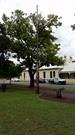
Metropolitan Sewerage Vents comprises six circular metal ventilation shafts approximately 30-50 feet (9-15 metres) high, with decorative cast iron bases providing rare evidence of the earliest establishment of deep sewerage system in Perth from 1911. The group is a smallrepresentative sample of the 1911 sewerage ventilation shafts, which have now largely been removed across the city and country.
A discontinuous group of Metropolitan Sewerage Vents. Each vent is similar in design, comprising an ornate circular cast iron base with fluting and moulding which contains the letters M S (Metropolitan Sewerage) in the lower portion. An access panel, measuring approximately 20cm by 10cm and secured by a bolt in each corner, provides visual access into the vents.
The collective group of Metropolitan Sewerage Vents were erected between c.1911 and 1928 to assist in reducing odours associated with the completion of Perth's new sewerage system. In 2013, Metropolitan Sewerage Vents remains as a collection of street furniture with no current functional use.
Historic site
| Epoch | General | Specific |
|---|---|---|
| Original Use | HEALTH | Other |
| Original Use | GOVERNMENTAL | Other |
| Type | General | Specific |
|---|---|---|
| Other | METAL | Cast Iron |
| General | Specific |
|---|---|
| SOCIAL & CIVIC ACTIVITIES | Community services & utilities |
| DEMOGRAPHIC SETTLEMENT & MOBILITY | Government policy |
| OUTSIDE INFLUENCES | Water, power, major t'port routes |
| DEMOGRAPHIC SETTLEMENT & MOBILITY | Technology & technological change |
This information is provided voluntarily as a public service. The information provided is made available in good faith and is derived from sources believed to be reliable and accurate. However, the information is provided solely on the basis that readers will be responsible for making their own assessment of the matters discussed herein and are advised to verify all relevant representations, statements and information.
11 Summers St East Perth
Vincent
Metropolitan
Constructed from 1914 to 1981
| Type | Status | Date | Documents |
|---|---|---|---|
| State Register | Registered | 08 Jan 2016 | HCWebsite.Listing+ListingDocument, HCWebsite.Listing+ListingDocument |
| Type | Status | Date | Documents |
|---|---|---|---|
| (no listings) |
| Type | Status | Date | Grading/Management | |
|---|---|---|---|---|
| Category | ||||
| Register of the National Estate | Indicative Place | |||
| Municipal Inventory | Adopted | 13 Mar 2001 | ||
| Perth Draft Inventory 99-01 | YES | 31 Dec 1999 | ||
| Classified by the National Trust | Classified | 10 Mar 1997 | ||
| Art Deco Significant Bldg Survey | Completed | 30 Jun 1994 | ||
| Name | Type | Year From | Year To |
|---|---|---|---|
| Babcock & Willcox | Architect | - | - |
| Merz McLellan | Architect | - | - |
| Structural Engineering Co of WA | Architect | - | - |
| Library Id | Title | Medium | Year Of Publication |
|---|---|---|---|
| 3138 | East Perth Power Station : Proposed Site Redevelopment - a Proposal to Refurbish and Modify a Heritage Power Station Complex to Create a Science and Technology Centre | Heritage Study {Other} | 1997 |
| 7166 | East Perth power station : a vision for the East perth Power Station : draft masterplan for community consultation. | Report | 2004 |
| 5234 | The East Perth Industrial Heritage Centre : East Perth Power Station redevelopment proposal : presentation, 19 September 2001 / National Trust of Australia (W.A.) | Report | 2001 |
| 9935 | Electricity generation, transmission and distribution in Western Australia: representation on the register of heritage places. | Report | 2007 |
| 2400 | Industrial heritage schools competition 1990. | Report | 1990 |
| 8666 | East Perth Power Station : Constructed Asset Assessment Report. (CAA) | Report | 2004 |
| 11783 | East Perth Power Station machinery inventory | Electronic | 2019 |
| 341 | From sailing ships to microchips : inaugural industrial heritage conference. Fremantle 15-16 June 1994. | Conference proceedings | 1994 |
| 11782 | East Perth Power Station Interpretation Strategy | Electronic | 2019 |
| 12023 | Walter's Brook Pump House archival record and significant fabric analysis: encompassing the Walter's Brook Pump House, pipework, equipment and associated contextual infrastructure at the East Perth Power Station (Place No 03318) | Archival Record | 2023 |
| 6885 | East Perth Power station Building B14, Laboratory fit-out : archival record. | Archival Record | 2004 |
| 410 | East Perth Power Station Conservation Plan vol 2: Illustrations, photographs, drawings, appendices - prepared for the East Perth Redevelopment Authority and State Energy Commission of Western Australia | Heritage Study {Cons'n Plan} | 1993 |
| 9531 | Swan and Helena rivers management framework: heritage audit and statement of significance, final report 26 February 2009. | Heritage Study {Other} | 2009 |
| 9844 | East Perth Power Station proposed site redevelopment. A proposal to refurbish and modify a heritage power station complex to create a science and technology centre. | Report | 1997 |
| 4934 | East Perth power station : government heritage property disposal report / Western Power Corporation. | Report | 2000 |
| 3211 | East Perth Power Station : proposed site redevelopment. | Report | 1997 |
| 7172 | East Perth Power Station skillion roofed extension to Blacksmith Shop & Store Building No.'s B2 and B22 : photographic archival record. | Archival Record | 2004 |
| 8664 | The urban studio: proposals for the East Perth power Station speculations in high density living. | Report | 2005 |
| 261 | A brief history of the development of East Perth power station The Institution of Engineers-Western Australian Division | Heritage Study {Other} | 1982 |
| 7174 | East Perth Power Station Walter's Brook Pump House Building No. B9 : photographic archival record. | Archival Record | 2004 |
| 8519 | First light: The development of a State Government Electricity and Gas supply. Part one. | Book | 0 |
| 7089 | East Perth Power Station : archival records for B38 and ancillary structures. | C D Rom | 2004 |
| 411 | East Perth Power Station Conservation Plan vol 3: Prepared for the East Perth Redevelopment Authority and State Energy Commission of Western Australia | Heritage Study {Cons'n Plan} | 1994 |
| 3210 | Scitech Discovery Centre and the East Perth Power Station - a Vision for the Future and a Link with the Past. | Report | 1997 |
| 272 | A brief history of the development of East Perth Power Station. | Heritage Study {Other} | 1981 |
| 7306 | East Perth power station precinct (draft masterplan). | Report | 2004 |
| 7313 | East Perth Power Station : Building B38, Power System Control Centre Building : photographic archival record. | Archival Record | 2004 |
| 7175 | East Perth Power Station Lift within 'A' Station Building No. B1 : photographic archival record. | Archival Record | 2004 |
| 11781 | East Perth Power Station conservation mangagement plan | Electronic | 2019 |
| 4565 | Report on East Perth Power Station : prepared for Western Power Corporation | Report | 1998 |
| 5966 | East Perth Power Station : archival documentary, 30 July 1997. | Video | 1997 |
| 7380 | East Perth Power Station : conservation issues - post inspection report. | Heritage Study {Other} | 2002 |
| 6532 | Western Australian endangered places 2003. | Kit | 2003 |
| 8665 | East Perth Power Station : building asset stabilisation report. (BAS) | Report | 2004 |
| 7173 | East Perth Power Station Metallurgical Laboratory Building No.'s B15 and B34 : photographic archival record. | Archival Record | 2004 |
| 10010 | Powering Perth; a history of the East Perth Power Station. | Book | 2011 |
| 260 | East Perth power station : heritage significance asessment report. | Heritage Study {Other} | 1992 |
| 7171 | East Perth Power Station Gatehouse Building No. B14 : photographic archival record. | Archival Record | 2004 |
| 7314 | East Perth Power Station : Coal Sample Storage Shed, 2 No. Concrete Water Tanks, Demineralising Water Treatment Plant House, Buildings 27 & 35 : photographic archival record. | Archival Record | 2004 |
| 12022 | Coal Tippler: Archival record and significant fabric analysis encompassing the coal tippler, coal tunnel and associated embankment at the East Perth Power Station (Place No. 03318) | Archival Record | 2023 |
| 9530 | Swan and Helena rivers regional recreational path development plan. | Report | 2009 |
| 409 | East Perth Power Station Conservation Plan vol 1: Prepared for the East Perth Redevelopment Authority and State Energy Commission of Western Australia | Heritage Study {Cons'n Plan} | 1993 |
| 6538 | East Perth Power Station. | Report | 2003 |
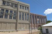
Individual Building or Group
| Epoch | General | Specific |
|---|---|---|
| Present Use | VACANT\UNUSED | Vacant\Unused |
| Original Use | GOVERNMENTAL | Power Station |
| Style |
|---|
| Inter-War Art Deco |
| Type | General | Specific |
|---|---|---|
| Wall | METAL | Steel |
| Roof | METAL | Corrugated Iron |
| Wall | BRICK | Common Brick |
| General | Specific |
|---|---|
| DEMOGRAPHIC SETTLEMENT & MOBILITY | Settlements |
This information is provided voluntarily as a public service. The information provided is made available in good faith and is derived from sources believed to be reliable and accurate. However, the information is provided solely on the basis that readers will be responsible for making their own assessment of the matters discussed herein and are advised to verify all relevant representations, statements and information.
449 Beaufort St Highgate
CORNER OF ST ALBAN'S AVE. FORMERLY KNOWN AS 423 BEAUFORT ST.
Vincent
Metropolitan
Constructed from 1898, Constructed from 1889
| Type | Status | Date | Documents |
|---|---|---|---|
| Heritage List | Adopted | ||
| State Register | Registered | 22 Jun 2010 | HCWebsite.Listing+ListingDocument, HCWebsite.Listing+ListingDocument |
| Type | Status | Date | Documents |
|---|---|---|---|
| (no listings) |
| Type | Status | Date | Grading/Management | |
|---|---|---|---|---|
| Category | ||||
| Classified by the National Trust | Classified | 20 Apr 2009 | ||
| Anglican Church Inventory | YES | 31 Jul 1996 | ||
| Municipal Inventory | Adopted | 13 Nov 1995 | Category A | |
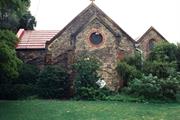
Saint Alban’s Church, Highgate is in sound condition although there is some spalling and delamination of walls, and in 2003 inappropriate repainting techniques and materials were being applied. The continued use of the place as a church has maintained it in fair general condition. Much of the building is covered in creeper, which in 2010 appears to have died.
| Name | Type | Year From | Year To |
|---|---|---|---|
| Joseph John (J.J.) Talbot Hobbs, 1889 design and 1898 extensions | Architect | 1889 | 1898 |
| Library Id | Title | Medium | Year Of Publication |
|---|---|---|---|
| 10192 | Celebrating one hundred years of God's grace:The beginnings and present lifeof St Alban's, Highgate 1889 -1989 | Electronic | 0 |
Individual Building or Group
| Epoch | General | Specific |
|---|---|---|
| Present Use | RELIGIOUS | Church, Cathedral or Chapel |
| Original Use | RELIGIOUS | Church, Cathedral or Chapel |
| Original Use | RELIGIOUS | Housing or Quarters |
| Present Use | SOCIAL\RECREATIONAL | Other Community Hall\Centre |
| Style |
|---|
| Victorian Romanesque |
| Type | General | Specific |
|---|---|---|
| Wall | BRICK | Other Brick |
| Wall | STONE | Limestone |
| Roof | TILE | Other Tile |
| Wall | BRICK | Common Brick |
| General | Specific |
|---|---|
| DEMOGRAPHIC SETTLEMENT & MOBILITY | Land allocation & subdivision |
| SOCIAL & CIVIC ACTIVITIES | Religion |
| SOCIAL & CIVIC ACTIVITIES | Community services & utilities |
This information is provided voluntarily as a public service. The information provided is made available in good faith and is derived from sources believed to be reliable and accurate. However, the information is provided solely on the basis that readers will be responsible for making their own assessment of the matters discussed herein and are advised to verify all relevant representations, statements and information.
Constructed from 1889 to 1898
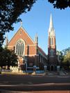
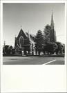
St Albans Church is a fine example of the early ecclesiastical architecture of J.J. Talbott Hobbs in the late 1880s and 1890s. Its Romanesque style marks a departure from the Gothic style previously preferred for Anglican churches. The church served Highgate Hill, the first suburb developed north of Perth. It was extended within a decade of its original construction. It has provided religious support to the Highgate Hill community and for parishioners in the local community for over 110 years.
The church is built of limestone with red brick quoins and buttresses in the informal Romanesque style, which in the late colonial period was often used as an alternative to the Gothic, which had been the preferred style for churches from the time of the dominance of the British ecclesiological movement, particularly in the colonies. The church consists of a gabled nave and sanctuary with a parallel gabled aisle, supplemented by gabled porches, chapel, vestry etc. Gables carry arched stained glass windows. The church has a fleche located above the western door. A free standing bell tower stands at the rear of the church. The pipe organ and other original interior details remain in place. The church is setback from the road in an open lawned setting with mature shrubs across the front of the building. 1970 hall addition
St Alban's Anglican Church, named after the first martyr of Britain, was built on five acres of bushland to serve the new subdivision of Highgate Hill, the first suburb on the north side of Perth. The area had been subdivided and developed by surveyor Charles Crossland in 1874, and named for his birthplace in London. Highgate Hill consisted of a small isolated cluster of homes erected for workmen's cottages, in the hollow on the east side of Beaufort Street. The first service was held on the stie under a gum tree in September 1888. A public meeting was held in January 1889 in the St George's Cathedral school room regarding 'the erection of a Mission Chapel at Highgate Hill'. Such was the response that enough money was raised for the work to go ahead and the foundation stone was laid the following month by Mrs Hare (27 February 1889). The church was designed by architect J.J. Talbot Hobbs and completed in just four months. It was consecrated on 13 June 1889. In 1895, a Rectory, also designed by Hobbs, was built on the Beaufort-Lincoln street corner of the site. The first Parish Hall was built on the Beaufort Street-St Alban's Ave corner and opened on 18 August 1896. The hall was used for Sunday School and later for Brownies and Girl Guides as well as for many other social occasions. In 1898, St Alban's became a separate parish and a mission was opened along with the hall. At that stage Beaufort Street was not formed much past St Alban's and 'night after night we went trampling through the sand signing hymns and bringing many back with us to the crowded hall'. (Revd F J Price, 1937). That same year the church was enlarged and a memorial stone for the extension was laid by Sir John Forrest on 30 July. The completed church was dedicated on 1 November 1898, on St Alban's Day. When St Alban's was built in 1889, it was planned that the window in the sanctuary, the middle window on each side wall and a small window in the front would be filled in with some stained glass which had been imported a decade earlier for St George's Cathedral, but not used. However the windows in the side walls, were fitted with clear glass instead, and the stained glass, depicting St Michael and St George, was later uncovered in a storage room. It was eventually installed when the Church was enlarged in 1898. At some later stage an organ made by Robert Cecil Clifton (1854-1931) was installed. It is still in use. Clifton also built three other organs for Anglican churches in Western Australia. The St Alban's one was built in 1902 for the music room in Clifton's Adelaide Terrace hme. At the time of its construction Clifton was a clerk in the Lands Department. Later on in his career he became Under Secretary for Lands. The original wooden parish hall was demolished and replaced by the present hall c.1970's.
Intact
| Name | Type | Year From | Year To |
|---|---|---|---|
| J. J. Talbot Hobbs | Architect | - | - |
This information is provided voluntarily as a public service. The information provided is made available in good faith and is derived from sources believed to be reliable and accurate. However, the information is provided solely on the basis that readers will be responsible for making their own assessment of the matters discussed herein and are advised to verify all relevant representations, statements and information.

57 Lincoln St Highgate
Cnr Smith St The adjacent block is the Highgate Police Station, which is on the RHP. The land on which the tower falls on is a difference reserve. These two different places share no history.
Dumas' Folly
Vincent
Metropolitan
Constructed from 1941
| Type | Status | Date | Documents |
|---|---|---|---|
| Heritage List | Adopted | ||
| State Register | Registered | 18 Dec 2007 | HCWebsite.Listing+ListingDocument, HCWebsite.Listing+ListingDocument |
| Type | Status | Date | Documents |
|---|---|---|---|
| (no listings) |
| Type | Status | Date | Grading/Management | |
|---|---|---|---|---|
| Category | ||||
| Municipal Inventory | Adopted | 13 Nov 1995 | Category A | |
| Classified by the National Trust | Classified | 28 Aug 1995 | ||
| Art Deco Significant Bldg Survey | Completed | 30 Jun 1994 | ||
Overall the condition is good, although there is some deterioration to the exterior of the building and cracking of the render.
| Name | Type | Year From | Year To |
|---|---|---|---|
| AE (Paddy) Clare, Principal Architect of PWD at time of construction | Architect | - | - |
| Russell Dumas, Chief Engineer PWD, oversaw engineering | Architect | - | - |
| Library Id | Title | Medium | Year Of Publication |
|---|---|---|---|
| 3342 | Lincon Street Ventilating Stack, Cottage, Former Police Station - Final Report | Heritage Study {Other} | 1997 |
| 8346 | Lincoln Street ventilation stack. | Heritage Study {Other} | 2004 |
Individual Building or Group
| Epoch | General | Specific |
|---|---|---|
| Original Use | GOVERNMENTAL | Other |
| Present Use | GOVERNMENTAL | Other |
| Style |
|---|
| Inter-War Art Deco |
| Type | General | Specific |
|---|---|---|
| Wall | RENDER | Other Render |
| Wall | BRICK | Common Brick |
| General | Specific |
|---|---|
| OUTSIDE INFLUENCES | Water, power, major t'port routes |
| PEOPLE | Innovators |
| OCCUPATIONS | Technology & technological change |
| SOCIAL & CIVIC ACTIVITIES | Community services & utilities |
This information is provided voluntarily as a public service. The information provided is made available in good faith and is derived from sources believed to be reliable and accurate. However, the information is provided solely on the basis that readers will be responsible for making their own assessment of the matters discussed herein and are advised to verify all relevant representations, statements and information.
Constructed from 1935
The Sewer Vent is a singular structure and landmark in Highgate, albeit the outcome of a failed experiment. It is a notable and monumental example of Interwar Art Deco. It has associations with the Police Wireless Service as the antennae for the wireless were camoflagued in the vent structure during the Second World War.
The tall tower has distinctive vertical Art Deco detailing and the appearance of a monument. It has a small building attached to its base, with battered retaining walls to the corner. The sewer vent was an experiment to improve the sewerage system to alleviate the possibilities of combustion and leakage of foul smells. It was considered to be a failure and the experiment was discontinued. Dominates its corner location None apparent
A sewer ventilation tower was constructed on the corner of the site on Reserve No. 45158 adjacent to the Highgate Hill Police Station. This Art Deco style tower was erected in in 1941, by the Public Works Department for the Metropolitan Water Supply Sewerage and Drainage Department. It was designed by A.E Paddy Clare, the principal architect for the PWD and the engineer was Russell J. Dumas. The tower was built to vent the acid-bearing air from the sewerage system into the atmosphere and prevent it corroding the concrete lined sewerage pipes. Two vents were constructed, one in Lincoln Street and one in Subiaco, but there is some doubt as to whether the latter one was built. Electric fans were used to extract the gas by pumping it up the tower. The Metropolitan Water Supply, Sewerage & Drainage Department was establihsed by an Act of Parliament in 1910. Through this all the water schemes were consolidated under on department, responsibe to the Minister of Water Supply, Sewerage & Drainage. Later (1925) part of it came under the PWD and so the departments pooled their resources. The Metropolitan Area was divided into three districts in 1910; Perth, Claremont and Fremantle with the Highgate area becoming part of Perth. After several name chnages, including the Water Authority of Western Australia (1985 - 1996), the department became the Water Corporation on 1 January 1996. Sewerage treatment works at Burswood and Claise Brook were completed and operational by January 1912. There were septic tanks installed at Claise Brook with an underground pipe to transport the sewerage to the percolating filters across the river on Burswood Island. After being treated the waste flowed into the river. As soon as the treatment works at Claise Brook were completed their were complaints about smell, particularly in East Perth. A new filter bed was added in 1913 but to no avail. Further new filter beds were added in 1918 and 1919 (when parts of Leederville and West Perth were sewered) annd in 1920 (making nine in all) but the problem persisted and there were reports of raw sewerage being sighted in the river. An ocean outfall was considered form the late 1920's. This and a new treatment plant in West Subiaco came into use in 1927 and when they were expanded some time in 1936, the works at Claise Brook and Burswood were excluded from thre system. The Lincoln Street sewer vent is 38 metres tall, including the one metre high plinth. It is the second tallest such structure in Australia. The tallest sewer vent, which is in Sydney, is 40 metres tall and was built in 1893. The reason for the height, was to carry the air from the sewer high above the area. During certain weather conditions, however, the polluted air did not vent upwards but dispersed through the system, causing much unpleasantness to the nearby residents. As a result of complaints, and the fact that the vent did not operate adequately, the connection to the sewerage system was closed (cemented over) and after four weeks of operation the tower rendered non-functional. Pipes near the ventilation tower collapsed in 1949 and the collapse was attributed to corrosion. The damage was repaired and the extractor fans were removed form the sewer vent at this time. The final solution to the corrosion and its effects was the installation of pipes lined with plastic in the late 1960's and 1970's and all the ventilation shafts around the Metropolitan Area. (Most of the other vents were metal designed to look like lamp posts). Perth now has a sealed system. In 1952 the chamber room at the base of the tower was converted to a laboratory for the chemical analysis of sewerage. It was the Department's first laboratory. Within the Public Works organisation the Lincoln Street ventilation stack was referred to as Dumas' Folly. Russell Dumas (later Sir, and for whom Dumas House is named) was chief engineer of the PWD from 1932 and director of works and buildings from 1941. Ralph Lake (father of Councillor Sally Lake) said it was often called 'monument to Hitler because it stank'. In late 1941 or early 1942, the central wireless section serving the police force was moved from police headquarters into the Highgate Hill Police Station. The wireless antennae was attached to the top of the sewer vent, which provided the perfect location. The move was completed almost within one day. The radio's call sign was VKI - Licence No. 1258. The location of the wireless section was kept secret at the time, as it was considered a prime bombing target. It is possible that during this time the station was also used by the Commonwealth Department of Defence for communication purposes. The wireless service had been established in 1930 with its transmitter at Wireless Hill in Applecross until 1936 when it was moved to the Central Police Station. In 1949 the Highgate Hill Police Station became the centre for vehicular communications which led to the formation of the Traffic Branch and Road Traffic Authority (RTA). In 1956 the wireless section was moved into the larger police quarters, and the building was extended to accommodate additional equipment and services. The quarters were further enlarged in 1969 with the addition of a new plant room, another transmission room and a carport, In 1975, the final year of tis operation at Highgate, VKI had radio connections with all the metropolitan police stations 338 vehicles and two launches plus links interstate and a country network of 39 base stations and 95 mobiles. In 1961 the Police Department began renting the room on the base of the tower, paying $.5.60 per month from then until 1975 when the wireless section was transferred to Police Headquarters in East Perth. Nevertheless the wireless antennae remained attached to the tower and the room of the tower is used by the Police Department as a training room and as a meeting place for the Police Historical Society of WA. Sally Lake later wrote: 'A few years ago a friend and I were given a tour of the old police station and the tower by a policeman who shared our interest in the history of the place. We entered the classroom by a door on the south side. At the north end of the room was what appeared to be a low cupboard door. When opened this revealed a tunnel along which we crawled. After a few feet we were able to look into the tower. Looking up we could see metal rungs set into the wall, going to the top. The tower was very high and tapered in. The base, a foot or so below us appeared to be concrete with a few stray items including a bicycle thrown in. In 1998 the ventilation stack was excised from the cancelled Reserve 6245 and was vested with the Water Corporation. In 1975, the wireless section was transferred to Police Headquarters in East Perth, but the wireless antennae are still attached to the tower.
Intact
This information is provided voluntarily as a public service. The information provided is made available in good faith and is derived from sources believed to be reliable and accurate. However, the information is provided solely on the basis that readers will be responsible for making their own assessment of the matters discussed herein and are advised to verify all relevant representations, statements and information.

40 Mary St Highgate
Incs: Monastery of Our lady of the Sacred Heart (Convent), Sacred Heart Primary School; Church; Hall; gardens, shelters, playing fields boundary walls. Bounded by Harold St.
Monastery of Our Lady of the Sacred Heart
Sacred Heart College
Sacred Heart Primary School
Vincent
Metropolitan
Constructed from 1899 to 1978
| Type | Status | Date | Documents |
|---|---|---|---|
| Heritage List | Adopted | ||
| State Register | Registered | 28 Aug 2001 | HCWebsite.Listing+ListingDocument, HCWebsite.Listing+ListingDocument |
| Type | Status | Date | Documents |
|---|---|---|---|
| (no listings) |
| Type | Status | Date | Grading/Management | |
|---|---|---|---|---|
| Category | ||||
| Municipal Inventory | Adopted | 13 Nov 1995 | Category A | |
02183 Sacred Heart Church, Halls & Presbytery
Good
| Name | Type | Year From | Year To |
|---|---|---|---|
| Casella Edgar & Wade | Architect | - | - |
| Richard Joseph Dennehy | Architect | 1859 | 1939 |
| Edgar Le B Henderson | Architect | - | - |
| Edgar Henderson, Henderson & Jeffries | Architect | - | - |
| Library Id | Title | Medium | Year Of Publication |
|---|
Individual Building or Group
| Epoch | General | Specific |
|---|---|---|
| Original Use | EDUCATIONAL | Combined School |
| Present Use | RELIGIOUS | Monastery or Convent |
| Present Use | EDUCATIONAL | Primary School |
| Original Use | RELIGIOUS | Monastery or Convent |
| Style |
|---|
| Federation Free Style |
| Federation Gothic |
| Inter-War Gothic |
| Type | General | Specific |
|---|---|---|
| Other | STONE | Limestone |
| Wall | BRICK | Common Brick |
| Roof | TILE | Terracotta Tile |
| Roof | METAL | Corrugated Iron |
| Wall | BRICK | Face Brick |
| General | Specific |
|---|---|
| SOCIAL & CIVIC ACTIVITIES | Education & science |
| SOCIAL & CIVIC ACTIVITIES | Religion |
This information is provided voluntarily as a public service. The information provided is made available in good faith and is derived from sources believed to be reliable and accurate. However, the information is provided solely on the basis that readers will be responsible for making their own assessment of the matters discussed herein and are advised to verify all relevant representations, statements and information.
Constructed from 1899 to 1991
Sacred Heart Group is a notable ecclesiastical and education group esteemed by the district community and the local Parish and School communities. Each of the places is a fine example of its style, with the major buildings being designed by notable architects of their day, renowned for their work for the Catholic Church. The place has associations with the orders of Sisters of Our Lady, Redemptorist Fathers, Christian Brothers and Bishop Gibney and Archbishop Clune.
The place is a complex of ecclesiastical buildings of different age, style, construction and height. It includes: The Monastery of Our Lady of the Sacred Heart, by Edgar Henderson, in the Federation Romanesque style, constructed in brick and render. The main façade features a two storey loggia, either side of a gabled central entry bay with tourelles. The shallow arch of the entry bay contrasts with the round headed arches of the loggia. Whilst varying in detail the two storey loggia was a popular feature of a number of Catholic Monasteries and Colleges of this period, eg. Clontarf and the Redemptorist Monastery. Sacred Heart Church, by R J Dennehy, is an exemplar of a plain and grave Federation Gothic style, constructed in rusticated stone. The simple gabled façade features three lancet windows rising above a round arched central doorway. Sacred Heart Primary School, by R J Dennehy, is a bold and innovative example of Federation Romanesque, with its tall roofed two storey wings masked by a two storey main façade, having extended corner towers, capped with 'widders walks'. The red brick of the facades is vividly enlivened with rendered bands that follow the arches of windows and openings and deep moulded bands, the depth of balustrades, at first floor, and parapet level. Single storey school extensions are in the Federation Arts and Crafts style. Sacred Heart Church Hall, by E LeB Henderson, is an example of an Interwar Free Classical style, with rusticated walls to reflect the stonework of the Church. It is very similar to the Star of the Sea Church Hall, at Cottesloe, also believed to be by E LeB Henderson. No. 64 Mary Street is a Federation Italianate single storey house with projecting gabled room facing the street with a faceted bay window and bullnose verandah set behind a front garden.
In 1892, land in Highgate Hill was acquired by the Roman Catholic Church and its subdivision into the Mount Heart Estate was supervised by Catholic Bishop Matthew Gibney. Its boundaries were Beaufort, Lincoln, Margaret (now Harold) and Mary streets. A two-acre site for a church and school, known as Alacoque Square after the Sacred Heart of Jesus, St Margaret Mary Alacoque, was set aside in the centre of a subdivision of 79 residential lots. A temporary church, in the form of a corrugated iron shed, was erected in the square. At that time, the Highgate Hill parish was administered and serviced from St Mary's Cathedral. In 1897, five sisters of the Order of Our Lady of the Missions came to Western Australia from Christchurch at the request of Bishop Gibney, and they opened the Sacred Heart School on 25 October 1897. Classes were held in the corrugated iron church building and by the end of the first year it had 140 students. On 18 September 1898, the foundation stone was laid for a combined school and convent, the Monastery of Our Lady of the Sacred Heart. The building, which cost approximately ₤3,000 (raised by the local parish), was opened on 22 January 1899. The architect was Edgar J. Henderson of Henderson and Jeffries, and the building was constructed with day labour, supervised by builder T. Maloney. It was reported in The Record as occupying a commanding site on the crown of the hill whence a widely spread view of the city and surrounding country is obtained. The situation is extremely healthy and an abundance of air is one of the chief characteristics of the place. The grounds are extensive, affording within their surrounding fence of galvanized iron, spacious room for recreational purposes and gardening. The material is brick faced with stone, and the appearance of the block is stately and imposing '“ the religious character being well marked. The design of the building is partly Gothic, the old English style of architecture predominating. The structure is two stories high. On the ground floor there is a school-room, 60 ft by 30 ft, exclusive of a stage 15 ft by 30 ft. The lower floor also contains the chapels, parlours, waiting room, music-room, refectory, kitchen, etc. In the upper story are a school for the boarders and another for the kindergarten, a dormitory, a community room and cells for the nuns. The building is excellently appointed in every aspect. (The Record 28.1.1899) This was the first school established by the order in Australia and Marie St. Genevieve was the 'prioress'. In 1910 Reverend Mother Mary Ambrose was in charge. As Highgate Hill and the surrounding areas developed and the school's reputation became established, the number of students grew and at times there were problems with overcrowding. As other schools were established, the Monastery at Highgate Hill became the Head House for the State, and later for Victoria. Between 1899 and 1903, the parish of Highgate Hill was served by the Redemptorist Fathers, who had taken up residence in two adjoining houses on Vincent Street, owned by Bishop Gibney. They remained in the parish until the Redemptorist Monastery was ready for occupation, early in 1903. The first Highgate Hill parish priest was Father Thomas Crowley, who remained from 1903 to 1936. By 1912, there were 400 students enrolled at the Sacred Heart School from kindergarten through secondary with 300 in the primary section. The foundation stone of a separate school building, the Sacred Heart Primary School, was laid by Archbishop Clune on 24 May 1914. The architect for the building was Mr Dennehy and the builder, Mr Fairweather. The cost of the building was ₤2,500. The school was opened on 20 October, while the east wing of the Monastery continued to be used as the girls' secondary school. Various additions were made to the monastery over the years to facilitate its continued use as a convent and as a boarding and high school for girls. In 1923, a chapel was added to the monastery, dedicated to the Little Flower, the venerable sister Teresa of the Child Jesus. It was the first built in Australia in memory of Little Flower. An appeal was made for funds to offset this debt and the Parish held competitions, concerts and bazaars to raise the money. Other additions at this time included the tower at the front of the east wing. The architect for the work was Edgar Le B. Henderson, son of Edgar J. Henderson (the original architect). Singleton and H.C. Pitman were the builders. The Sacred Heart Church was completed in 1928. The foundation stone for the new construction was laid on Palm Sunday, 1 April 1928, by Archbishop Clune. The architect for the church additions was R.J. Dennehy and the builders were Todd Bros. The altar was designed by Edgar Henderson. The church had seating accommodation for over 400 when the additions were completed. A later addition, the Lady Chapel, was opened on 25 March 1954. In 1933, a third floor was added to the chapel and the accommodation wing, and in 1934 two rooms, two dormitories and a bathroom were added, again designed by Edgar Le B. Henderson. In 1937 with 603 students enrolled, the auxiliary wing, comprising a laundry and various storerooms was added at the rear of the east wing. By the 1960s the facilities were overtaxed and out-of-date. Plans for a new school and convent were developed on a site at Sorrento. This new school opened in 1968. In 1970 Fourth Year was moved to the new school from Highgate. The remainder of the high school classes moved to Sorrento in 1980, and the Maylands Convent became the Head House for the order, with many of the sisters moving there. The Sisters of Our Lady of the Missions were no longer involved in the running of the schools, having turned their attention to pastoral care. Alterations and renovations were carried out to the monastery in 1987, including the installation of more bathroom facilities, and portion of the roof was replaced. The architectural firm of Casella Edgar & Wade was involved in the work. The Primary School numbers had continued to increase over the years, necessitating the provision of pavilion classrooms. During World War II 90 students and 12 sisters were evacuated to Moorine Rock. Then after the War there was a dramatic rise in enrolments with a baby boom and many new migrants settling in the inner city area. Additions were carried out in 1953 and in 1955 the kindergarten in Harold Street was demolished. In 1967 the primary and high schools were amalgamated in order to rationalize resources. The high school hall was demolished in 1971 and a new school wing was constructed at a cost of $90,000 aided by Commonwealth Government funding. In 1977, a hostel was added to the monastery for the provision of aged care for the sisters. The primary school numbers received another boost in the 1980s as a result of migration from South East Asia, and the intake of boys in Years 5, 6 and 7 to create a fully co-educational school. As with most Catholic primary schools to this time, the upper primary classes had been segregated with the boys attending schools staffed by the male religious orders, such as the Christian Brothers. In 1982 additions were made to the school and it was re-roofed and a classroom block at the rear was demolished. Changes were also made to doors, windows, ceilings, cabinets and the electrical and plumbing arrangements in the early 1980s. In the late 1980s, the primary school took over the east wing and the 1971 school wing of the monastery, which had remained empty since the secondary school classes had moved out. In 1987 alterations and renovations costing $180,000 were carried out. In 1991, a new pre-primary section and staff room were added to the 1914 building. The additions were designed by John Edgar of Casella Edgar & Wade Architects, and built by Doubkin Constructions. In November 1999 there were 247 students at the primary school and 21 on the teaching staff. The corrugated iron shed which had been used as the first church and school building was retained and used as a parish hall until 1938-39, when it was demolished and replaced with a modern rendered-brick building. The new parish hall cost ₤2,130, and was designed by Edgar Le B. Henderson & A. Gamble and built by the McGann Brothers. It is situated immediately to the rear of the Church at 42 Mary Street on the corner of Harold Street and the right-of-way. At some time, the parish acquired the weatherboard residence on the adjoining site at No. 197 Harold Street and this is used as the parish meeting place. This residence was built circa1950, and was originally occupied by Robert Ryan. The place was destroyed by fire in 2006 and has since been demolished. The first parish priest, Father Crowley, lived at the Queen's Hotel until about 1909, when Patrick McCafferty provided a house at 7 Mary Street for use as a presbytery. In 1942 this was sold and 50 Vincent Street, the former home of Bishop Gibney, was re-purchased and served as the presbytery for the Highgate Hill parish for many years until 64 Mary Street, next door to the Church, was purchased. No. 64 Mary Street was designed by architect H.J. Prockter and described as a 'villa residence' on his 1899 plan. It was built in 1901 as a private residence for W. Phillips, a contractor but Wise's Post Office Directories for that year indicate that the resident was W.A. Clifford. In 1909 the owner/occupier was William Phillips and the capital value was assessed as ₤850. He was still there in 1928. In 1937 the resident listed was Mrs Ellen Phillips (possibly a widow of William). In 1949, the last year of the Directories, Laurence Band was residing at No. 64 and a No. 64a was also listed. It was occupied by Alexander Robinson. Approval was granted for alterations in 2000 designed by Phillip McAllister Architect Pty Ltd for stage one of an Early Childhood Centre. The builder was Palace Homes & Construction Pty Ltd. Alterations and additions, again designed by Phillip McAllister, were carried out in 2003. This work included the demolition of a two-storey 1960s school building, a 1970s hostel building and a 1930s laundry. Phillip McAllister Architects received the Town of Vincent's Heritage Award in the Municipal Heritage Inventory Category for this work in 2005. Permission was also granted to change the use of the hall building and kitchen to include a library, museum, office and archival storage through alterations and additions (designed by Santelli Architects) in late 2007. Other buildings which have been associated with the Sacred Heart Group include the former Christian Brothers Intermediate School (now St Mark's International School) on the corner of Stirling and Harold streets. This institute was opened in February 1936 as a residence and school, and initially took boys from Sacred Heart Primary School for their upper primary and secondary education. The Sacred Heart Junior High School was opened as a Montessori School in August 1929 on Learoyd Street in Mt Lawley. This is now St Paul's Primary School. The subject place was entered on the Permanent Register of Heritage Places in November 2000
High in all cases
| Name | Type | Year From | Year To |
|---|---|---|---|
| Edgar J. Henderson; Edgar Le B. Henderson; R. J. Dennehy | Architect | - | - |
This information is provided voluntarily as a public service. The information provided is made available in good faith and is derived from sources believed to be reliable and accurate. However, the information is provided solely on the basis that readers will be responsible for making their own assessment of the matters discussed herein and are advised to verify all relevant representations, statements and information.
40-42 Mary St Highgate
Vincent
Metropolitan
Constructed from 1906
| Type | Status | Date | Documents |
|---|---|---|---|
| (no listings) |
| Type | Status | Date | Documents |
|---|---|---|---|
| (no listings) |
| Type | Status | Date | Grading/Management | |
|---|---|---|---|---|
| Category | ||||
| Catholic Church Inventory | Adopted | 01 Jul 1998 | ||
02181 Sacred Heart Catholic Group, Highgate
Good
| Name | Type | Year From | Year To |
|---|---|---|---|
| Richard Joseph Dennehy | Architect | 1906 | - |
Individual Building or Group
| Epoch | General | Specific |
|---|---|---|
| Original Use | RELIGIOUS | Church, Cathedral or Chapel |
| Present Use | RELIGIOUS | Church, Cathedral or Chapel |
| Style |
|---|
| Federation Gothic |
| Type | General | Specific |
|---|---|---|
| Wall | STONE | Limestone |
| General | Specific |
|---|---|
| SOCIAL & CIVIC ACTIVITIES | Religion |
This information is provided voluntarily as a public service. The information provided is made available in good faith and is derived from sources believed to be reliable and accurate. However, the information is provided solely on the basis that readers will be responsible for making their own assessment of the matters discussed herein and are advised to verify all relevant representations, statements and information.

42 Mary St Highgate
REGISTERED AS PART OF 2181 Sacred Catholic Group, Highgate
Sacred Heart Convent & School
Sacred Heart Convent (fmr)
Vincent
Metropolitan
Constructed from 1899
| Type | Status | Date | Documents |
|---|---|---|---|
| (no listings) |
| Type | Status | Date | Documents |
|---|---|---|---|
| (no listings) |
| Type | Status | Date | Grading/Management | |
|---|---|---|---|---|
| Category | ||||
| (no listings) | ||||
02181 Sacred Heart Catholic Group, Highgate
Good
| Name | Type | Year From | Year To |
|---|---|---|---|
| Edgar Henderson | Architect | 1899 | - |
Individual Building or Group
| Epoch | General | Specific |
|---|---|---|
| Present Use | EDUCATIONAL | Primary School |
| Present Use | EDUCATIONAL | Office or Administration Bldg |
| Original Use | RELIGIOUS | Monastery or Convent |
| Style |
|---|
| Federation Romanesque |
| Type | General | Specific |
|---|---|---|
| Roof | METAL | Corrugated Iron |
| Wall | BRICK | Face Brick |
| Wall | BRICK | Rendered Brick |
| General | Specific |
|---|---|
| SOCIAL & CIVIC ACTIVITIES | Education & science |
| SOCIAL & CIVIC ACTIVITIES | Religion |
This information is provided voluntarily as a public service. The information provided is made available in good faith and is derived from sources believed to be reliable and accurate. However, the information is provided solely on the basis that readers will be responsible for making their own assessment of the matters discussed herein and are advised to verify all relevant representations, statements and information.
42 Mary St Highgate
Vincent
Metropolitan
Constructed from 1938 to 1939
| Type | Status | Date | Documents |
|---|---|---|---|
| (no listings) |
| Type | Status | Date | Documents |
|---|---|---|---|
| (no listings) |
| Type | Status | Date | Grading/Management | |
|---|---|---|---|---|
| Category | ||||
| Catholic Church Inventory | Adopted | 01 Jul 1998 | ||
02181 Sacred Heart Catholic Group, Highgate
good
| Name | Type | Year From | Year To |
|---|---|---|---|
| Edgar Henderson | Architect | 1938 | - |
Individual Building or Group
| Epoch | General | Specific |
|---|---|---|
| Present Use | RELIGIOUS | Church Hall |
| Original Use | RELIGIOUS | Church Hall |
| Type | General | Specific |
|---|---|---|
| Wall | BRICK | Face Brick |
| Roof | TILE | Ceramic Tile |
| General | Specific |
|---|---|
| SOCIAL & CIVIC ACTIVITIES | Religion |
This information is provided voluntarily as a public service. The information provided is made available in good faith and is derived from sources believed to be reliable and accurate. However, the information is provided solely on the basis that readers will be responsible for making their own assessment of the matters discussed herein and are advised to verify all relevant representations, statements and information.

31 Smith St Highgate
Vincent
Metropolitan
Constructed from 1954
| Type | Status | Date | Documents |
|---|---|---|---|
| Heritage List | Adopted | ||
| State Register | Registered | 28 Mar 2014 | HCWebsite.Listing+ListingDocument, HCWebsite.Listing+ListingDocument |
| Type | Status | Date | Documents |
|---|---|---|---|
| (no listings) |
| Type | Status | Date | Grading/Management | |
|---|---|---|---|---|
| Category | ||||
| Municipal Inventory | Adopted | 13 Nov 1995 | Category B | |
The Serbian Orthodox Church of St Sava is an outstanding example of a church designed in the Christian Orthodoc Church tradition, whereby all elements including the ornate art works of the interior, the finely painted iconostasis, frescoes, mosaicsm gold chandeliers and timber furniture, including a throne, are of religious importance.
Serbian Orthodox Church of St. Sava comprises a Post-War Ecclesiastical style rendered masonry church (1954-55), with a western bell tower (1974), and a separate brick and tile Sunday School building (1962), with additions (1971, 1984), situated in landscaped gardens.
The first Serbian Orthodox church service was hep in Western Australia in 1951 at a Greek Orthodox Church in Perth. Father Petar Rados played an important role in raising funds for the construction of the Serbian Orthodox Church of St Sava, which was constructed in 1954-55.
good
Individual Building or Group
| Epoch | General | Specific |
|---|---|---|
| Original Use | RELIGIOUS | Church, Cathedral or Chapel |
| Present Use | RELIGIOUS | Church, Cathedral or Chapel |
| Style |
|---|
| Post-War Ecclesiastical |
| Type | General | Specific |
|---|---|---|
| Roof | TILE | Other Tile |
| Wall | BRICK | Common Brick |
| General | Specific |
|---|---|
| SOCIAL & CIVIC ACTIVITIES | Religion |
| DEMOGRAPHIC SETTLEMENT & MOBILITY | Immigration, emigration & refugees |
This information is provided voluntarily as a public service. The information provided is made available in good faith and is derived from sources believed to be reliable and accurate. However, the information is provided solely on the basis that readers will be responsible for making their own assessment of the matters discussed herein and are advised to verify all relevant representations, statements and information.
Constructed from 1954 to 1974
The Serbian Orthodox Church of Saint Sava is a fine example of the Postwar Immigrant Nostalgia style, based on the design principles of the Orthodox Church, applied to an ecclesiastical landmark. The Church demonstrates the cultural diversity of the community and provides a special place for the Serbian community, who constructed the place and use it as a place of worship and a focus of their society.
Built in a traditional Orthodox style, the building features white stucco walls and two octagonal towers, with cupolas topped with crosses, centered over the ridge of the gable roof, consistent with eastern European inspiration. The towers have arched windows on each facet. The building is entered from the side via a small flight of stairs with metal rails, through an arched doorway into a shallow entry narthex. At the eastern end, attaching to the gabled main section of the church, is a large projecting apse with its own tiled roof. Windows to walls and apse cum sanctuary are groups of three arched windows, symbolising the Holy Trinity. Setback from the street behind a low brick and steel rail fence. None apparent
The Serbian Church of St Sava was constructed in 1954 by the Serbian community, most of whom had fled Yugoslavia following World War II. It was named after Saint Sava (1175-1235), the first Bishop of Serbia and founder of the Serbian Orthodox Church. He is the most important saint in the Serbian Orthodox Church and the patron saint of education and medicine. His father also took monastic vows and he was canonised at Saint Simon. The foundation stone was laid on 31 January 1954, and the church was consecrated on 1 February 1956. In 1974, the bell tower was erected and the building completed. In 1979, three mosaics were set into the exterior wall of the bell tower. One of these was donated by a founder member of the church, one by the Ladies' Guild and one by the organisation of Serbian Chetniks in WA in memory of their leader, Draza Himajlovic (1893-1946). Himaljlovic was the leader of the resistance movement known as the Chetniks, and distinguished himself as their commander and later as Minister of War, and materially contributed to the Allied cause during World War II. However, he ordered the ethnic cleansing of Croats, Bosniaks and others and was tried after the War and executed for treason. The construction of the church is illustrative of the various waves of migration that have occupied the Highgate and other northern inner-city areas. In fact, many of those involved in its construction were refugees from Yugoslavia following World War II. It is one of two Serbian Orthodox churches in WA, the other being Saint Trojica in Marlborough Street, Mount Lawley. In 1965 the church bought two cottages in Stirling Street (Nos 318-322) adjoining the rear boundary of the church. These cottages were built in 1887 and were demolished in 1999 to make way for two, two-storey units, thus providing more accommodation. Objections were lodged to prevent the demolition of what was believed to be the oldest duplex in the Town of Vincent. However, these were overruled by then Heritage Minster Graham Kierath. At that time Fr Peter Rados was the vicar-general of the Serbian-Orthodox Church in Australia and New Zealand. In 2008 he was the rector of the Church of Saint Sava and Bishop Milutin was the ruling Bishop of the Serbian Orthodox Diocese of Australasia. Other changes to the complex included a brick Sunday School building in 1962, school additions in 1971 and a brick storeroom was erected in 1984. In 2006 the official maximum number of people who could be accommodated in the church was 87 and 145 people in the hall.
High
This information is provided voluntarily as a public service. The information provided is made available in good faith and is derived from sources believed to be reliable and accurate. However, the information is provided solely on the basis that readers will be responsible for making their own assessment of the matters discussed herein and are advised to verify all relevant representations, statements and information.
Vincent St Highgate
MHI notes other address as 505 William St
Third Swamp
Third Swamp Reserve
Vincent
Metropolitan
Constructed from 1897
| Type | Status | Date | Documents |
|---|---|---|---|
| Heritage List | Adopted | ||
| State Register | Registered | 30 Oct 1998 | HCWebsite.Listing+ListingDocument, HCWebsite.Listing+ListingDocument |
| Type | Status | Date | Documents |
|---|---|---|---|
| (no listings) |
| Type | Status | Date | Grading/Management | |
|---|---|---|---|---|
| Category | ||||
| Municipal Inventory | Adopted | 13 Nov 1995 | Category A | |
| Library Id | Title | Medium | Year Of Publication |
|---|---|---|---|
| 8002 | Hyde park conservation plan. | Heritage Study {Cons'n Plan} | 2003 |
| 9250 | Hyde Park Lakes preparation of a masterplan for their restoration. | Heritage Study {Other} | 2008 |
| 9272 | Hyde Park. Photograph record of Children's playground. | Archival Record | 0 |
| 7321 | Hyde park artwork proposal. | C D Rom | 2005 |
Urban Park
| Epoch | General | Specific |
|---|---|---|
| Original Use | PARK\RESERVE | Park\Reserve |
| Present Use | PARK\RESERVE | Park\Reserve |
| Style |
|---|
| Other Style |
| General | Specific |
|---|---|
| SOCIAL & CIVIC ACTIVITIES | Community services & utilities |
| DEMOGRAPHIC SETTLEMENT & MOBILITY | Aboriginal Occupation |
| OUTSIDE INFLUENCES | Depression & boom |
| DEMOGRAPHIC SETTLEMENT & MOBILITY | Environmental change |
| SOCIAL & CIVIC ACTIVITIES | Sport, recreation & entertainment |
This information is provided voluntarily as a public service. The information provided is made available in good faith and is derived from sources believed to be reliable and accurate. However, the information is provided solely on the basis that readers will be responsible for making their own assessment of the matters discussed herein and are advised to verify all relevant representations, statements and information.
Constructed from 1897
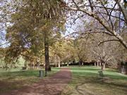
Hyde Park is highly valued by the local and wider community as a fine and mature Federation Arcadian landscape. It forms a visual, social and recreational focus for the neighbourhood and the wider community. It has scientific and historic value as a remnant of a chain of wetlands that extended through the district. It is a notable example of the aspirations for wetlands that were held during the Federation period. The site has important associations for Aboriginal people. It also has a significant collection of mature introduced trees and remnant indigenous flora.
Hyde Park is a well established park bounded by Vincent, Glendower, Throssell and William Streets. Its lake feature has been divided into two basins with islands, surrounded by mature London Plane trees. Numerous other mature trees are spread throughout the park, including Moreton Bay Figs and Port Jackson Figs in the lawn areas, Pines around the boundaries and Jacarandas in the south-east corner. Other plantings include Swamp Cypress, Red Cedar, Bunya Pine and remnant indigenous Eucalyptus and Melaleuca. Each portion of the lake has an island occupied by breeding birds. The park contains a network of pathways, BBQ facilities and children's playground equipment. Hyde Park was established in the Arcadian style of landscape design, which attempts to recreate an idyllic rural landscape, featuring gently undulating grassed areas, irregular groups of large trees, winding pathways, irregularly shaped shrubberies and natural water bodies. Landscaped parkland, tree lined lakes and meandering paths. Recent additions of limestone-edged planter beds and ornate paving depart from the original Arcadian style.
Originally known as Third Swamp, the area was an Aboriginal camping ground prior to and during the early part of European settlement. In the latter half of the 19th Century, when Aboriginal people were restricted from entering the Perth City area, Third Swamp was one of the few camping places remaining to them. The Swamp was prone to flooding and attempts were made to drain it and reclaim the land for residential purposes. Drainage was stopped after nearby wells began to dry up and the area was set aside as a reserve in 1873. Third Swamp was considered a good duck-hunting area by Europeans, and it was used as a camping ground by travelers, particularly during the gold rush period of the 1890s. A Public Works Department (PWD) Sewerage Plans dated 1897 shows that the area was a swamp full of vegetations. On 30 September 1897, largely through the efforts of Lyall Hall, Perth auctioneer and land agent, Third Swamp was gazetted for the purpose of Public Gardens. On 31 July 1899, Third Swamp was renamed Hyde Park, after London's park of the same name. The Park was placed in the care of the City's Gardening inspector, John Braithwaite, who was the municipal gardener from 1896 to 1936. A Government grant of £1,000 was made to Perth City Council for improvements. The area was surrounded with a picket fence to prevent cattle and horses entering, 600 trees were planted, rushes were removed from the swamp and a lake was formed. An ornate fountain was donated by William Brookman in 1901, and installed at the intersection of Glendower and Lake streets. A practice cricket pitch was added in 1906, and the perimeter Pine trees were planted in 1912. The lake dried up that same year and, in 1913, it was dredged and the soil used to create two islands. A roadway was begun through the centre of the park, but as a result of public opposition it was modified to a walkway separating the lake into two. In 1914-15 the picket fence was replaced with a fence of concrete posts and iron railing (not extant), and a bandstand rotunda was added. The Jacaranda trees were planted in 1921-23 and the Park was extended to include additional land on Vincent Street. The stone retaining walls around the lakes were built in 1936-37. Prior to1930s, the Wise's Post Office Directories list Hyde Park as at Vincent Street whilst from that year the place is listed under William Street. In the 1960s, the Park was refurbished with new play equipment, water playground, barbecues, picnic areas, improved lavatory facilities, lighting and upgraded pathways. A resurgence of use saw the first Hyde Park Festival held in 1968. The last Festival was held in 1985 but a more limited Hyde Park Fair was resurrected a few years later and continues to be held annually. The Park is a popular venue for other community events, social gatherings and private ceremonies such as weddings. On 6 January 1977, Perth Town Lot Y228 was granted to the City of Perth as freehold land to be used and held solely for recreation purposes. It was transferred to the Town of Vincent under the same conditions on 11 April 1995. In 1998 Hyde Park was placed on the State Register of Heritage Places. In June 2003 a Conservation Plan was prepared for the Park which provides a detailed documentary and physical evidence of the Park, and recommendations to guide any redevelopment and changes to the Park in line with its cultural heritage significance. In 2007, the Town of Vincent Council resolved to approve the design of the Hyde Park Stage. This stage proposal was also supported by the Heritage Council.
High
This information is provided voluntarily as a public service. The information provided is made available in good faith and is derived from sources believed to be reliable and accurate. However, the information is provided solely on the basis that readers will be responsible for making their own assessment of the matters discussed herein and are advised to verify all relevant representations, statements and information.
William St Highgate
near corner of William and Glendower St, next to bus stop on Hyde Park side of William St
Vincent
Metropolitan
| Type | Status | Date | Documents |
|---|---|---|---|
| Heritage List | Adopted |
| Type | Status | Date | Documents |
|---|---|---|---|
| (no listings) |
| Type | Status | Date | Grading/Management | |
|---|---|---|---|---|
| Category | ||||
| Municipal Inventory | Adopted | 28 Jun 2016 | Category A | |
23992 Metropolitan Sewerage Vents
Other Built Type
| Epoch | General | Specific |
|---|---|---|
| Original Use | GOVERNMENTAL | Other |
| Type | General | Specific |
|---|---|---|
| Other | METAL | Cast Iron |
| General | Specific |
|---|---|
| SOCIAL & CIVIC ACTIVITIES | Community services & utilities |
| DEMOGRAPHIC SETTLEMENT & MOBILITY | Settlements |
This information is provided voluntarily as a public service. The information provided is made available in good faith and is derived from sources believed to be reliable and accurate. However, the information is provided solely on the basis that readers will be responsible for making their own assessment of the matters discussed herein and are advised to verify all relevant representations, statements and information.
This information is provided voluntarily as a public service. The information provided is made available in good faith and is derived from sources believed to be reliable and accurate. However, the information is provided solely on the basis that readers will be responsible for making their own assessment of the matters discussed herein and are advised to verify all relevant representations, statements and information.
30-42 Franklin St & 338-342 Shakespeare St Leederville
Includes: St Mary's Novitiate & Convent (fmr), St Mary's Catholic Church, Aranmore Presbytery & Aranmore Catholic College
Arranmore; St Mary's Convent and School
St Mary's College, Christian Brothers College
Vincent
Metropolitan
Constructed from 1923 to 1982
| Type | Status | Date | Documents |
|---|---|---|---|
| Heritage List | Adopted | ||
| State Register | Registered | 03 Jun 2005 | HCWebsite.Listing+ListingDocument, HCWebsite.Listing+ListingDocument |
| Type | Status | Date | Documents |
|---|---|---|---|
| (no listings) |
| Type | Status | Date | Grading/Management | |
|---|---|---|---|---|
| Category | ||||
| Municipal Inventory | Adopted | 13 Nov 1995 | Category A | |
| Aboriginal Heritage Sites Register | Recorded | |||
| Name | Type | Year From | Year To |
|---|---|---|---|
| W G Bennett, Allen and Allen | Architect | - | - |
| Ernest H Hamilton | Architect | 1923 | - |
| Berry Brothers | Architect | 1923 | - |
| Oldham, Harold Boas & Ednie-Brown and Partners | Architect | - | - |
| Matthew Broderick and Partners | Architect | 1968 | - |
| Library Id | Title | Medium | Year Of Publication |
|---|---|---|---|
| 9281 | Sisters of Mercy in Australia: Responses to health, illness and disease by a women's religious order. | Electronic | 2008 |
Individual Building or Group
| Epoch | General | Specific |
|---|---|---|
| Original Use | RELIGIOUS | Church, Cathedral or Chapel |
| Other Use | RELIGIOUS | Monastery or Convent |
| Original Use | RELIGIOUS | Housing or Quarters |
| Original Use | EDUCATIONAL | Combined School |
| Present Use | EDUCATIONAL | Combined School |
| Present Use | RELIGIOUS | Office or Administration Bldg |
| Other Use | RELIGIOUS | Office or Administration Bldg |
| Style |
|---|
| Inter-War Gothic |
| Inter-War Romanesque |
| Type | General | Specific |
|---|---|---|
| Roof | TILE | Other Tile |
| Wall | BRICK | Other Brick |
| Other | STONE | Other Stone |
| Other | TIMBER | Other Timber |
| General | Specific |
|---|---|
| SOCIAL & CIVIC ACTIVITIES | Education & science |
| SOCIAL & CIVIC ACTIVITIES | Religion |
This information is provided voluntarily as a public service. The information provided is made available in good faith and is derived from sources believed to be reliable and accurate. However, the information is provided solely on the basis that readers will be responsible for making their own assessment of the matters discussed herein and are advised to verify all relevant representations, statements and information.
Constructed from 1923 to 1942
The Aranmore Catholic College Group is both an ecclestiastical and educational landmark in the area. Its order and character creates a strong sense of place and a valued extension of the public domain. The place has significant associations with the Sisters of Mercy, Christian Brothers, Monsignor Maloney and Ernest Hamilton. It demonstrates significant developments in education, worship, community services and a way of life. It is an integral part of the local Catholic community, as well as the wider community.
A group of ecclesiastical buildings including St Mary's Church, presbytery, college and former convent. CHURCH: The church is a red brick and tile building in the Inter-War Gothic style, with characteristic stone mullioned windows, parapeted gable, spire and other vertical elements and entrance porch. Imposing gable roofed church with a tall bell tower and spire. Constructed with gothic design elements including arched windows and doors and buttresses at the sides. The central and side windows feature characteristic stone tracery and stained glass lead lights. The building has a projecting entrance porch at the front. A spire of this scale is unusual in a suburban parish church, being more commonly found on cathedrals. PRESBYTERY: This two storeyed brick and tile residence has a two storeyed timber verandah on three sides. The projecting front rooms have a gable that is topped with a cross and has a simple vertical rectangular vent feature. This projection also has a horizontal band of stucco above and below each window, and a fifth band across the gable. Original timber balustrades on the upper verandah have been replaced by metal railing. The presbytery is situated adjacent to St Mary's Church, facing Franklin Street. FORMER CONVENT: A two storey red brick and tile building with symmetrical projecting wings at either end, each with a gable end, and connected by a two storeyed verandah or colonnade. The façade features decorative horizontal stucco bands which are typical of the period. The windows mirror those of St Mary's Presbytery, part of the Aranmore complex, with those on the lower floor being divided into nine square lights (3x3, the top 3 being fanlights) and those on the top floor being regular casement windows hung with 3 square fanlights. HALL: A local hall with ground floor shop front appearance to Oxford Street. It is truncated at the corner and has a corner doorway. The rendered front gable has a cross at its apex. The date '1929' is on the gable. The hall itself extends along Franklin Street, which slopes upwards. Tall windows are set into each section of the hall, defined by projecting pilasters. The group occupies the entire street block bounded by Oxford, Salisbury, Marion and Shakespeare Streets and incorporates Franklin Street and includes landscaped areas, paving, playing fields and carpark areas. Numerous modifications to facilitate the continued development and use of the place.
The Sisters of Mercy established a convent and primary school on the corner of Marian and Shakespeare Streets in 1903. The Sisters of Mercy is a religious order founded by Catherine McAuley in Ireland in 1831. The sisters' mission is to serve the poor and the needy with many engaging in medical care, community programs and teaching. The Leederville school opened in an existing weatherboard house and it was known as Our Lady of Perpetual Succour Convent, Aranmore. A weatherboard school building was established further west on Marian Street. This building was most likely also used for church services. It is shown on the MWSSDD sewerage plan of c.1930 as being constructed in the traditional cross-shape. The Leederville Parish was established on 1 March 1919, and the first presbytery was an existing cottage at 46 Franklin Street. The first parish priest was the long-serving Monsignor J. F. Maloney (1919-1958). Theresa Leeder occupied a house on the corner of Franklin and Shakespeare streets, and when she died on 26 October 1922, this land was purchased in March 1923 as the site for St Mary's Church. The foundation stone for the church was laid on 6 May 1923 and the Church was opened on 9 December that year. The architect for St Mary's Church was Ernest H. Hamilton. Hamilton originally worked as a draughtsman for the Public Works Department and was involved with the design of Perth Modern School in 1909. As a privately employed architect in the 1920s, he designed the Subiaco Clock Tower war memorial. He was most likely assisted with the design of St Mary's Church by Leederville parish priest Monsignor J.F. Maloney, who was known for his forceful and outspoken opinions. Mons Maloney was the parish priest from 1919 - 1958, and was a driving force in the development of the parish and the Aranmore College group. The Berry Brothers, members of the Leederville parish, were responsible for the extensive jarrah joinery in the Church. Monsignor Maloney became very well - known in the district and some of the St Mary's school girls recalled being frightened of him because he was so stern. They dared not be late to church as he called to them and made them walk down the whole length of the aisle to the front pews. He was remebered by others with fondness and for being a man he could turn his hands to most things. One resident recalled seeing him perched high on the steeple doing some maintenance with his cassock flying in the breeze. In 1929, a church hall, reputed to have been moved from the goldfields, was erected on the corner of Franklin and Oxford streets. This was named St Mary's Hall. It presents a shop-front to Oxford Street, and the front two rooms may have been used originally to house an op-shop or some similar fund-raising function for the parish. Many early residents recall going to weddings, dances and other fund raising functions in this hall and the children attended the school's annual fancy dress ball there. On 21 November 1933, the Sisters of Mercy opened the new novitiate and convent building. They were then able to extend the school to secondary level for girls. The school was renamed St Mary's College. The following year, a new Presbytery was built on the west side of the Church, directly opposite the new convent building, and the priests took up residence on 5 November that year. Monsignor Maloney is credited with the design of this presbytery. In 1937, St Mary's Church was enlarged and the bell tower added, the additions being blessed by the Archbishop on 13 February 1938. The terrazzo Communion rail, which was added at this time, was made by Fanzan Brothers of Perth. The Church bell had been cast at the O'Byrne Foundry in Dublin in 1928. The iron and stone fencing around the Church on both street frontages was erected in 1956. In February 1942, the Christian Brothers opened their college on the adjoining site west of St Mary's College with 140 boys. In 1971, the senior classes at St Mary's and CBC were amalgamated and St Mary's Primary School moved to a new site on Brentham Street in 1976. The Christian Brothers established an upper primary school for the boys on Jugan Street, Glendalough. Various other buildings were added to the two secondary school complexes over the years, and they shared some facilities, including a library, canteen and sports grounds. In 1986, St Mary's and CBC amalgamated as Aranmore Catholic College, a fully co-ed school. Franklin Street was closed to vehicular traffic and landscaped. In 1991, the St Mary's convent building was remodeled for offices and classrooms, with new convent accommodation being provided on Shakespeare Street, opposite the College complex. St Mary's Parish Centre, a hall building of domestic scale, was constructed in 1968, behind St Mary's Hall. The architect was Matthew Broderick and the builder Fennesey Holdings Pty Ltd. The Parish Centre is well patronized by groups in the parish, but has little heritage significance. Following construction of the Parish Centre, St Mary's Hall, no longer required as a church hall, became part of the school complex. The Hall continues to be used as the venue for lower school social functions, music and drama concerts, graduation ceremonies, meetings, parent group functions, and any other activity that requires a large space, including local community use as an election polling place.
Mostly intact
| Name | Type | Year From | Year To |
|---|---|---|---|
| Ernest Hugh Hamilton (church) | Architect | - | - |
This information is provided voluntarily as a public service. The information provided is made available in good faith and is derived from sources believed to be reliable and accurate. However, the information is provided solely on the basis that readers will be responsible for making their own assessment of the matters discussed herein and are advised to verify all relevant representations, statements and information.
40 Franklin St Leederville
Cnr Franklin & Shakespeare Sts
Vincent
Metropolitan
Constructed from 1923 to 1968
| Type | Status | Date | Documents |
|---|---|---|---|
| State Register | Registered | 14 May 1999 | HCWebsite.Listing+ListingDocument, HCWebsite.Listing+ListingDocument |
| Type | Status | Date | Documents |
|---|---|---|---|
| (no listings) |
| Type | Status | Date | Grading/Management | |
|---|---|---|---|---|
| Category | ||||
| Catholic Church Inventory | Completed | 01 Jul 1998 | ||
| Aboriginal Heritage Sites Register | Recorded | |||
08709 Aranmore Catholic College Group
good
| Name | Type | Year From | Year To |
|---|---|---|---|
| Ernest H Hamilton | Architect | 1923 | - |
| Library Id | Title | Medium | Year Of Publication |
|---|---|---|---|
| 3555 | Conservation Plan for St Mary's Church Leederville, Western Australia | Heritage Study {Cons'n Plan} | 1998 |
Individual Building or Group
| Epoch | General | Specific |
|---|---|---|
| Original Use | RELIGIOUS | Church, Cathedral or Chapel |
| Original Use | RELIGIOUS | Church Hall |
| Present Use | RELIGIOUS | Church Hall |
| Present Use | RELIGIOUS | Church, Cathedral or Chapel |
| Present Use | RELIGIOUS | Housing or Quarters |
| Original Use | RELIGIOUS | Housing or Quarters |
| Style |
|---|
| Inter-War Gothic |
| Type | General | Specific |
|---|---|---|
| Roof | TILE | Other Tile |
| Wall | BRICK | Common Brick |
| General | Specific |
|---|---|
| SOCIAL & CIVIC ACTIVITIES | Religion |
This information is provided voluntarily as a public service. The information provided is made available in good faith and is derived from sources believed to be reliable and accurate. However, the information is provided solely on the basis that readers will be responsible for making their own assessment of the matters discussed herein and are advised to verify all relevant representations, statements and information.

156 Oxford St Leederville
Cnr Vincent St
Vincent
Metropolitan
Constructed from 1897
| Type | Status | Date | Documents |
|---|---|---|---|
| Heritage List | Adopted | ||
| State Register | Registered | 01 Dec 1995 | HCWebsite.Listing+ListingDocument, HCWebsite.Listing+ListingDocument |
| Type | Status | Date | Documents |
|---|---|---|---|
| (no listings) |
| Type | Status | Date | Grading/Management | |
|---|---|---|---|---|
| Category | ||||
| Municipal Inventory | Adopted | 13 Nov 1995 | Category A | |
| Statewide Post Office Survey | Completed | 01 Mar 1992 | ||
| Classified by the National Trust | Classified | |||
| Name | Type | Year From | Year To |
|---|---|---|---|
| J H Grainger | Architect | - | - |
Individual Building or Group
| Epoch | General | Specific |
|---|---|---|
| Original Use | Transport\Communications | Comms: Housing or Quarters |
| Present Use | Transport\Communications | Comms: Post or Telegraph Office |
| Original Use | Transport\Communications | Comms: Post or Telegraph Office |
| Style |
|---|
| Federation Romanesque |
| Type | General | Specific |
|---|---|---|
| Roof | TILE | Other Tile |
| Wall | BRICK | Common Brick |
| General | Specific |
|---|---|
| TRANSPORT & COMMUNICATIONS | Mail services |
This information is provided voluntarily as a public service. The information provided is made available in good faith and is derived from sources believed to be reliable and accurate. However, the information is provided solely on the basis that readers will be responsible for making their own assessment of the matters discussed herein and are advised to verify all relevant representations, statements and information.
Constructed from 1897
Leederville Post Office (former) is important as one of four remaining (5 originally) post offices of similar design, from this period. Its corner location makes it a significant element in the streetscape of the town centre. It was significant for its post office activity which generated considerable activity and was the hub of written communications for much of its time of operation.
The one storey building has a tiled hipped roof and a symmetrical front with central entry brick arched verandah - three facing the main street and one at each end. The severity of the external facades is a measure of the change of design direction between Temple Poole and Grainger. The two central pillars of the three front arches feature low simplified ionic capitals. It originally included a residence for the post master as well as the post office, however renovation during the 1990's has removed most of the original internal partitioning. Nil setbacks Internal considerable
The suburb of Leederville was named after William Leeder who arrived in Western Australia aboard the Rockingham in 1830. He took up Swan Locations Ac and Ad on the eastern side of Lake Monger. Between these and further allocations, he ended up having all the land in what is now known as the suburb of Leederville (the family home was erected on the hill where St Mary's Church now is.) The area was declared a Roads Board district in 1895, a municipality in 1896 and later under the control of the City of Perth. When the Town of Vincent was formed in 1995, Leederville came under its jurisdiction. The Leederville Post Office is one of only four remaining examples of a suburban post office which incorporated a post master's residence and one of a series built to serve the rapidly expanding suburban areas during the gold rush period. Others built in the same period included the Aberdeen Street, Brisbane Street, Victoria Park and (now demolished) Hay Street post offices. All exhibited a similar style, adapted for their sites. Although Leederville Post Office was built under the direction of PWD Chief Architect J. H. Grainger, the design continued the pattern established by his predecessor, George Temple Poole, but with some small variations. The foundation stone made from Meckering granite, was laid by E.H. Wittenoom, Minister for Posts and Telegraphs, on 3 May 1897. During the ceremony he spoke about the development of the area and added: ' I am very pleased to know that so close to Perth there was so much land available for cutting up for small allotments, where people could live more comfortably than in the more crowded city. If it was one thing they desired more than another it was that people should acquire land and settle down and erect homes from themselves. A leaden box containing, among other things, current newspapers, a Government Gazette, Year Book, postage stamps and working drawings of the building, was placed behind the stone. The contract for its construction was let to A. Davenport in February 1897 and the building was completed in September at a cost of £1,168. It was one of five public buildings erected on the Fitzroy Park Estate. The others were the Leederville Primary School (1896), headmaster's house (No. 164 Oxford Street 1897 - 1985), Municipal Chambers (1897 - 1940_ and the Police Station (1897 - 1964). It was first listed in the 1898 edition of Wise's Post Office Directories, but the postmaster's name was not included. In 1899 the postmistress was Miss Matilda Pollard and she remained there until 1910 when John. G Cornish took over. Early resident Gordon Hughes said that in the early years the Post Office used to look lilke a house with chimnyes and open fireplaces. These were later taken off and the bricks were used to build at the rear. The building was extended and altered further over the years, with some former windows being replaced with private letter boxes. The post office function was extended into the residential section of the building was adpated as the district developed. The postmen and telegram boys all used push bieks to deliver the mail and telegrams and there were two deliveries of mail each day. In the 1940's the area they covered was very large from 'North Perth, part of West Perth, Leederville, Mount Hawthorn, Joondanna and Glendalough and part of Osborne Park' (Les Beckham OH). At that time there was a Morse Room at the rear where all the telegrams were deciphered. When Les Beckham worked there some of the other staff were Jack Branch, Mr Rinaldi and Brian Simpson. Unfortunately, in 1949 the last year of the Directories no mention was made of the postmaster but it indicated that a public telephone box had been erected outside sometime previously. Peter Ryan was one of the longer serving postmasters having been appointed in the 1970's and he was still there in the early 1990's. It was around that time that Leederville's postal requirements eventually outgrew the building and a new postal facility was provided in a new building adjacent at No. 288 Vincent Street. In the late 1990s, the Post Office was purchased by a private individual and sympathetically converted to an eating house, the Post Cafe in 1997. In 1999 a two storey building was constructed at the rear with a frontage onto Vincent Street for shop/offices and a car park. In 2008 these shops were tenanted by Hair Candy and the Leederville Post Office. Other restaurants followed Post Cafe including the franchise 'Nandos' followed by the coffee shop franchise 'Dome', with alterations being made to cater for this in 2007.
Moderate to High
| Name | Type | Year From | Year To |
|---|---|---|---|
| George Temple Poole & J. H. Grainger | Architect | - | - |
This information is provided voluntarily as a public service. The information provided is made available in good faith and is derived from sources believed to be reliable and accurate. However, the information is provided solely on the basis that readers will be responsible for making their own assessment of the matters discussed herein and are advised to verify all relevant representations, statements and information.

177 Oxford St Leederville
Leederville Mechanics' Institute
RAAF Barracks & Drill Hall
Vincent
Metropolitan
Constructed from 1909
| Type | Status | Date | Documents |
|---|---|---|---|
| Heritage List | Adopted | ||
| State Register | Registered | 22 Jan 2002 | HCWebsite.Listing+ListingDocument, HCWebsite.Listing+ListingDocument |
| Type | Status | Date | Documents |
|---|---|---|---|
| (no listings) |
| Type | Status | Date | Grading/Management | |
|---|---|---|---|---|
| Category | ||||
| Municipal Inventory | Adopted | 13 Nov 1995 | Category A | |
Sound structural condition
| Library Id | Title | Medium | Year Of Publication |
|---|---|---|---|
| 5270 | Conservation Plan for Drill Hall, Leederville, (fmr) Mechanics Institute, 300-314 Vincent Street, Leederville. | Heritage Study {Cons'n Plan} | 2001 |
| 5445 | Heritage report Building Licence submission Oxford Lane Residential Development : RAAF Base Leederville. | Report | 2001 |
Individual Building or Group
| Epoch | General | Specific |
|---|---|---|
| Original Use | MILITARY | Drill Hall |
| Present Use | MILITARY | Barracks |
| Present Use | MILITARY | Drill Hall |
| Style |
|---|
| Federation Free Classical |
| Type | General | Specific |
|---|---|---|
| Wall | BRICK | Common Brick |
| Roof | METAL | Corrugated Iron |
| General | Specific |
|---|---|
| OUTSIDE INFLUENCES | World Wars & other wars |
| SOCIAL & CIVIC ACTIVITIES | Education & science |
This information is provided voluntarily as a public service. The information provided is made available in good faith and is derived from sources believed to be reliable and accurate. However, the information is provided solely on the basis that readers will be responsible for making their own assessment of the matters discussed herein and are advised to verify all relevant representations, statements and information.
Constructed from 1909
The former RAAF Air Training Corps, Drill Hall and Mechanics Institute was constructed to the design of leading architect Edgar J Henderson. It was acquired as part of a Federal Government program at the start of the First World War. It was continuously used and developed by the armed services until its sale in 2000. It had close associations with education of the early Vincent community and then with district wide recruitment and training for the armed service for more than 85 years.
The Mechanics Institute developed the Hall behind the streetfront annexe. The annexe is built to the footpath in a Federation Free Classical style. The parapeted façade of the annexe has a tripartite composition. Above the parapet is a central pediment, which has carried the consecutive names of the hall. The annexe is designed around a large entry hall with offices and lounge. The front offices have pressed tin ceilings in a number of different designs. The hall was a functionalist brick hall with a high pitched galvanised iron roof. Its northern end was a temporary wall behind a raised stage with side wings. These were removed following the change from Mechanics Institute to Drill Hall. Subsequently offices were constructed along the western wall requiring the original high level windows to be filled in. The change from Drill Hall to Air Training Corp brought minimal change. During 2004 extensive redevelopment was conducted on the site, involving the Drill Hall's original structure being converted into residential and commerical use. The site's old parade ground has been landscaped to reflect the cultural heritage significance associated with the site. Zero front setback to Vincent Street, and very close to the Mitchell Freeway off ramp along the side. Various
Part of the subject site, at the corner of Vincent Street (this portion was formerly known as Redan Street) and Stamford Street (then known as Frogmore Gardens), was initially owned by James Stewart Bennet in 1896. The land was transferred to Maria Burges in 1901 and the Leederville Mechanics Institute in 1908. The building now known as Drill Hall was the then Leederville Mechanics Institute. Mechanics Institutes were established to provide the working man with uplifting and educational reading material, and a place to meet for lectures. The first Leederville Mechanics Institute was part of the Municipal Chambers, built at another site on Oxford Street in 1898. The building quickly proved too small for both functions and a new Leederville Mechanics Institute was built at the subject site along Redan Street. The building was designed by Edgar J. Henderson and the contract for construction was awarded to Franklin and Finlay. The foundation stone was laid on 8 December 1908. With the introduction of compulsory military training in Australia in 1911 prior to World War One, the Commonwealth Defence Department needed extra drill halls. Leederville Mechanics Institute was acquired by the Defence Department for use as a drill hall in 1913 and was then known as Leederville Drill Hall. This building consisted of a large single space, approached through an entry annexe of hallway, opened to Vincent Street and flanked by four offices. Following the outbreak of World War One, the Leederville Drill Hall was used for recruiting and training. Extra land was acquired adjoining the hall site, which provided an area for a parade ground. There was a weatherboard cottage on the land at time of acquisition. This was removed in 1922-23. In 1919, there were 13 drill halls in Perth and another 17 in country areas. Use of the drill halls fluctuated over the years. Various other structures were added to the site at Leederville, resulting in some 15 structures, many of them temporary or transportable. In 1960, the site was referred to as the Western Command Signal Squadron Depot. Circa 1979, Leederville Drill Hall was taken over by the RAAF (Royal Australian Air Force) for use by the Air Training Corps. In recent years a number of suburban drill halls have been sold. Leederville Drill Hall was offered for public tender in 2000. During 2004 the site underwent extensive redevelopment in which a number of buildings at the site have been demolished, including a house at No. 2 Stamford Street, a commercial shop 'Cooling Brothers' at No. 177 Oxford Street and several demountable buildings and sheds. The original Drill Hall has been retained and the whole site converted to residential and commercial use. The project's success was recognized with a Town of Vincent 2003 Building Design and Conservation Award win.
Moderate
| Name | Type | Year From | Year To |
|---|---|---|---|
| Edgar J. Henderson | Architect | - | - |
This information is provided voluntarily as a public service. The information provided is made available in good faith and is derived from sources believed to be reliable and accurate. However, the information is provided solely on the basis that readers will be responsible for making their own assessment of the matters discussed herein and are advised to verify all relevant representations, statements and information.

217 Oxford St Leederville
IOOF Buffaloes Lodge (fmr)
Oddfellows Hall
Vincent
Metropolitan
Constructed from 1898
| Type | Status | Date | Documents |
|---|---|---|---|
| Heritage List | Adopted | ||
| State Register | Registered | 22 May 2015 | HCWebsite.Listing+ListingDocument, HCWebsite.Listing+ListingDocument |
| Type | Status | Date | Documents |
|---|---|---|---|
| (no listings) |
| Type | Status | Date | Grading/Management | |
|---|---|---|---|---|
| Category | ||||
| Municipal Inventory | Adopted | 13 Nov 1995 | Category A | |
Oddfellows Hall (fmr), Leederville, a two storey limestone building designed in the Federation Free Classical style, with single storey later brick additions to the rear, has cultural heritage significance for the following reasons: the place was purpose-built in 1898 for the Grand United Order of Odd Fellows to provide medical services and financial assistance prior to these matters becoming government-managed social services; the place is a rare remaining example of a mutual benefit society building in Western Australia. Few buildings of the Odd Fellows movement remain in Western Australia; and the fa�ade of the place is a fine example of Federation Free Classical Style architecture.
Oddfellows Hall (fmr), Leederville is a two storey limestone and iron building in the Federation Free Classical Style with corrugated iron roof. There are two additions to the rear of the building; a 1950s single storey brick addition to the north, and a 1970s two storey brick addition to the south.
The Oddfellows Hall (fmr) was constructed in 1896 on Oxford Street in Leederville by the Grand United Order of Odd Fellows (GUOOF). It was used for a variety of community purposes in the early nineteenth century, before being utilised for a variety of retail uses from 1917. In 2006 it underwent a series of refurbishment works and is currently leased for use by an Optometry business, 'Eyes on Oxford'.
| Name | Type | Year From | Year To |
|---|---|---|---|
| A W Hoskins (Archer William Hoskins also known as Hoskings ) | Architect | - | - |
Individual Building or Group
| Epoch | General | Specific |
|---|---|---|
| Present Use | COMMERCIAL | Shop\Retail Store {single} |
| Original Use | SOCIAL\RECREATIONAL | Other Community Hall\Centre |
| Present Use | COMMERCIAL | Other |
| Style |
|---|
| Federation Free Classical |
| Type | General | Specific |
|---|---|---|
| Roof | METAL | Corrugated Iron |
| Wall | BRICK | Face Brick |
| General | Specific |
|---|---|
| SOCIAL & CIVIC ACTIVITIES | Community services & utilities |
| SOCIAL & CIVIC ACTIVITIES | Institutions |
This information is provided voluntarily as a public service. The information provided is made available in good faith and is derived from sources believed to be reliable and accurate. However, the information is provided solely on the basis that readers will be responsible for making their own assessment of the matters discussed herein and are advised to verify all relevant representations, statements and information.
Constructed from 1898 to 1899
The remaining front of the IOOF Buffaloes Lodge is a rare example of the Federation period and a landmark in Oxford Street. It has close associations with the establishment of the International Order of Oddfellows in Perth in 1898 and later the Friendly Societies Health Services (FSHS).
The two storey stone building has fine stucco decoration to the parapet above the rusticated stone cladding of the upper walls. The central bay projects to highlight the main entrance to the hall. The parapet features a central pediment. All of the window and door openings are square headed with concrete lintols over each opening. The upper floor windows are of equal size, each having three casements topped by square fanlights. On the ground floor there are two shops symmetrically presented either side of the entry door to the lodge. The original verandah has been replaced with a cantilevered awning. Zero setback on Oxford Street. Although built on a corner it is fully orientated towards Oxford Street. The original verandah has been replaced with a cantilevered canopy. The original ground floor shop fronts have been substantially altered. The hall has been removed.
The building was constructed for the International Order of Oddfellows (IOOF), as a timber hall with a two-storey stone façade comprising two rooms up and down. The IOOF was established in Western Australia in 1898, and was one of several friendly societies that operated in the State. The IOOF is an organisation based on non-profit mutual self-help. It was run by a Board of Directors elected from among its members. It grew and diversified over the years, and was a founding partner in the Friendly Societies Health Services (FSHS), a major health fund which was taken over by the Hospital Benefits Fund (HBF) in 1984. Other benefits provided included funeral assistance, funeral cover, pharmacy benefits, travel service and general insurance. The foundation stone for the Leederville IOOF Buffaloes Lodge is believed to have been laid by John Forrest. It was surreptitiously removed under the cover of night, however was returned in 2008 and has been reinstated at the building. Inscribed on the stone was the following: This stone was laid by The Hon. Sir John Forrest K.C.M.G. Premier On 3rd November 1896 A.W. Hoskins ARIBA Building Committee Architect (Illegible) Although the names of the building committee were illegible on the foundation stone, it was reported in the Western Mail on 6 November 1896 that they were two members of the order, Brothers J.H. Ede and R. Howard. The article also indicated that members of the Pioneer Lodge and Bohemia Lodge and visitors from the Fremantle lodges were also present at the stone laying ceremony. Wise's Post Office Directories show Walter Male as the Secretary in 1899. In 1901 it was just listed as the Leederville Hotel. The Oddfellows do not appear to have used the Hall for any great length of time but early residents remember going to fancy dress balls there when they were students at Leederville State School. Margaret Beadle also remembered that St Barnabas had their annual concert there. The back portion of the hall was burnt down around 1906 and in 1910 it is possible understood that John Randall, a produce merchant was operating at the front. At this time the building was numbered 123 Oxford Street. In 1914 it appears the property was renumbered 201 and 203 and the two rooms at the front of the hall were used as shops. Mrs Carlisle, a confectioner, was in No. 201 and No. 203 was vacant at that time. It was not until 1917 that it became No. 217, when it was listed as vacant. It was in that year that it caught the attention of the local Health Inspector who found that people were gaining access to the building through a broken window and using it as a public convenience. The hall section had been removed by November 1917, to be used as part of the temporary buildings for the University on Western Australia, on St George's Terrace. Brick additions at the rear appear to have been added at some early time following the removal of the hall. In 1919 the place was occupied by Peter Minn, a greengrocer and in 1920 by confectioner, Mrs M.A Connolly. In 1921 two of the street numbers were listed for the first time: Mrs Connolly was still operating at No. 217 and Albert E. Moorman, a bootmaker was at No. 22. The following year Albert was still at No. 221 and his wife operated a confectionery at No. 217 and one early resident recalled standing at the window, working out how many sweets they could get for their half penny. In the years that followed the place was occupied by various retail and commercial enterprises, including as a grocer and greengrocer, bootmaker, and tobacconist and a brothel at one stage but often with one of the two shops were vacant. In the 1930s No. 219 was included in the Directories' listing. During this period until 1946, Mrs Z. Nelson had a fancy goods store at No. 221 and A. Nelson ran a book shop at No. 219 and crockery distribution business at No. 217. Following this the building was used by a fishmonger, mixed business in 1949 and then later on a second-hand shop, a restaurant/food outlet, which was very popular with the TAFE students across the road who were able to play chess there, and a dental surgery . In 1960 some reconstruction work was carried out at the rear of the building by the then owner, P Panizza. The building was bought by Dr Pat Cranley in the 1980s and he used No. 221 for his surgery. He rented the shop next door to several hairdressers and following that his daughter Margaret ran her craft shop, Chantilly Lace there. The upstairs was accommodation and in 2002 another daughter, Louise Cranley, a country school teacher, was using it as a Perth base. Dr Cranley employed a receptionist, Mrs Cranley, from the 1990s until her husband's death in 2004. Mrs Cranley was situated at the front adjacent to where the waiting room area was and he had two rooms behind that where he saw his patients. His was a family practice initially. He called it a 'geriatric' practice because the average age of his patients was 77. Then '˜they died out and then we had a mixed, jumbled up practice, then we had a bit of a yuppy practice' and later on a '˜drug practice'. Dr Cranley treated addicts, often with revolutionary methods, some of which did not find favour with the authorities. However, as a result of his work in medicine, with migrants, Rotary and so on, Dr Cranley received many awards, including Metropolitan Senior of the Year two weeks before his death in October 2004. Following his death, the place was sold and the current owners (2008) are in the process of restoring the building, which will include the reinstating the foundation stone to its original position on the left-hand side of the main entrance. When finished it is believed the space will be rented to an optician.
Façade intact Remainder low/missing
This information is provided voluntarily as a public service. The information provided is made available in good faith and is derived from sources believed to be reliable and accurate. However, the information is provided solely on the basis that readers will be responsible for making their own assessment of the matters discussed herein and are advised to verify all relevant representations, statements and information.
336 Oxford St Leederville
Cnr Franklin St
Vincent
Metropolitan
Constructed from 1929
| Type | Status | Date | Documents |
|---|---|---|---|
| (no listings) |
| Type | Status | Date | Documents |
|---|---|---|---|
| (no listings) |
| Type | Status | Date | Grading/Management | |
|---|---|---|---|---|
| Category | ||||
| (no listings) | ||||
08709 Aranmore Catholic College Group
Individual Building or Group
| Epoch | General | Specific |
|---|---|---|
| Present Use | COMMERCIAL | Office or Administration Bldg |
| Original Use | RELIGIOUS | Church Hall |
| Type | General | Specific |
|---|---|---|
| Roof | METAL | Corrugated Iron |
| Wall | EARTH | Other Earth |
| Wall | RENDER | Roughcast |
| Wall | BRICK | Common Brick |
| General | Specific |
|---|---|
| SOCIAL & CIVIC ACTIVITIES | Religion |
This information is provided voluntarily as a public service. The information provided is made available in good faith and is derived from sources believed to be reliable and accurate. However, the information is provided solely on the basis that readers will be responsible for making their own assessment of the matters discussed herein and are advised to verify all relevant representations, statements and information.
38 Kalgoorlie St Mount Hawthorn
Vincent
Metropolitan
Constructed from 1916
| Type | Status | Date | Documents |
|---|---|---|---|
| Heritage List | Adopted | ||
| State Register | Registered | 20 Oct 2000 | HCWebsite.Listing+ListingDocument, HCWebsite.Listing+ListingDocument |
| Type | Status | Date | Documents |
|---|---|---|---|
| (no listings) |
| Type | Status | Date | Grading/Management | |
|---|---|---|---|---|
| Category | ||||
| Municipal Inventory | Adopted | 13 Nov 1995 | Category A | |
| Register of the National Estate | Permanent | 28 May 1996 | ||
| Classified by the National Trust | Classified | 12 Jun 2089 | ||
| Statewide War Memorial Survey | Completed | 01 May 1996 | ||
| Name | Type | Year From | Year To |
|---|---|---|---|
| A. Levido | Architect | - | - |
| Library Id | Title | Medium | Year Of Publication |
|---|---|---|---|
| 1205 | Anzac Cottage | Heritage Study {Cons'n Plan} | 1996 |
| 9246 | ANZAC Cotage souvenir of the monument erected at Mount Hawthorn 1916. | Heritage Study {Other} | 0 |
Individual Building or Group
| Epoch | General | Specific |
|---|---|---|
| Original Use | MONUMENT\CEMETERY | Monument |
| Original Use | RESIDENTIAL | Single storey residence |
| Present Use | EDUCATIONAL | Museum |
| Style |
|---|
| Federation Queen Anne |
| Type | General | Specific |
|---|---|---|
| Wall | BRICK | Face Brick |
| Other | TIMBER | Other Timber |
| Roof | TILE | Terracotta Tile |
| General | Specific |
|---|---|
| SOCIAL & CIVIC ACTIVITIES | Community services & utilities |
| OCCUPATIONS | Technology & technological change |
| OUTSIDE INFLUENCES | World Wars & other wars |
This information is provided voluntarily as a public service. The information provided is made available in good faith and is derived from sources believed to be reliable and accurate. However, the information is provided solely on the basis that readers will be responsible for making their own assessment of the matters discussed herein and are advised to verify all relevant representations, statements and information.
Constructed from 1916
ANZAC Cottage is unique in Australia as a memorial to the Great War, which also provided a home for returned soldier Private Cuthbert Porter, until 1971. The place is a good and intact example of the Federation Bungalow style. It is a rare example of an architect designed ’workers cottage’. The house was constructed by community effort in a single day on the 12 February 1916. The place has close associations with Private Porter, the Mt Hawthorn Progress Association, the local community and the Vietnam Veteran’s Association.
This single storey red brick, hipped roof cottage has a broken pitch verandah supported by timber posts. The symmetrical façade is decorated with stucco bands and decoration under the triple casement windows either side of the central front door. The twin gablets are infilled with roughcast. The roof has terracotta tiles. The word "ANZAC" is written in coloured leadlight in the fanlight above the front door. Cemented front steps with urns lead to the verandah. There is a flag pole in the front yard. Setback appropriate to residential context. The flat site has minimal plantings. 1960s rear extensions removed in 1997.Restoration in 1997
This building is unique in Australia in that it was the first war memorial built to commemorate those who had fought in World War 1 and also that it was built as a house to accommodate a returned soldier. Its construction was initiated by the Mount Hawthorn Progress Association in 1915. In December that year the Westralian Worker announced: 'It is to perpetuate the memory of Australia's gallant sons who took part in this now historic landing that the Mount Hawthorn Progress Association are appealing for funds to erect a practical monument. Once of those who took his place in the attack on April 25th and who has returned to us disabled for life is Private John Porter, and it is intended that the monument to be erected should take the form of a home for Mr Porter and his wife and child, which will be called 'Anzac Cottage'. Private Cuthburt John Porter migrated to Western Australia in 1913. He enlisted in the Australian Imperial Forces on 3 September 1914 and his regimental number was 1013. He was wounded in action at the Dardanelles, Gallipoli Peninsula on 23 June 1915 and repatriated home. He was discharged from the Armyon 10 July 1916, having declared medically unfit due to a wound in his left leg with several pieces of shrapnel lodged behind his kneecap. Fund raising for the cottage began in earnest with ex/Mayor John Veryard being the first to donate. Such was the response from the public that the original idea of a 'small wooden structure' was soon upgraded to a four-roomed brick cottage. In all they raised £185 and the remainder was met by donations of labour and goods. The land for the cottage was provided by real estate agent James Peet, for £25 and the site was described as 'overlooking the northern shores of Monger's Lake and surrounded by some of the finest scenery in the Metropolitan area'. The site was cleared by 30 volunteers during the first of three busy bees held on 29 January 1916, with the Ladies Patriotic Guild providing afternoon tea. Preparations fo the joinery work had also began at that time. Building materials, furnishings and money were provided by Perth businesses, and a "carter's bee" held on 5 February 1916, resulted in a half-mile long procession of vehicles transporting materials to the site. The Anzac Cottage souvenir booklet stated that: 'No finer display of Patriotic and industrial effort has ever been seen in Perth than .. when 70 drays, laden with building material, formed up a procession.. Fully 150 men gave up their Saturday afternoon.. Mrs C Roberts, the 'Soldiers Queen' headed the processsion in her motor car, which also carried a Metters' stove and copper , and was accompanied by two other decorated motor cars. Then came 20 drays of stone, 27 of bricks, 1 of lime, 3 of tiles, 12 of timber, 1 of cement and paintss, 1 of scaffolding, 1 tiled grate, 1 large enamel bath, 1 of refreshments, and 1 of sundries. The procession was viewed by thousands as it proceeded to Mount Hawthorn, and on arrival at 'Anzac" was greeted by hundreds of enthusiastic men, women and children. The architect for Anzac Cottage was Alfred Levido, who lived in Coogee Street. Councillor Sidney Gibson, a building contractor, supervised the construction, which involved over 200 volunteers from the community and took place in a single day, 12 February 1916 (the third busy bee), with women serving hot meals in relays to the workers. Construction began at 3am and by 5pm a flag was raised with 'A.N.Z.A.C' embroidered on it - the cottage being virtually completed within this one day. The Perth City Gardener supervised the laying of the lawn, and the house was completed with fence and flag pole. When completed the cottage was valued at £600 and the deeds were subsequently vested in the Trustees of the Progress Association. On 15 April 1916, Anzac Cottage was officially opened by the Premier John Scadden and his wife who unlocked the door adn declared it open in fornt of a crowd of 3,000 people, including officials from Mount Hawthorn Progress Association. it was officially handed over to Private Porter, the following day, Mrs C. Roberts who had started the first trench for the foundations. The deeds were vested in the Trustees of the Progress Association. The Porter family occupied the cottage from 1916 to 1917 and one of this tasks every year on Anzac Day was to raise the flag at 4am to commemorate the Gallipoli landings. After his death in 1964, his wife Annie carried on the tradition until her own death in 1978. Private Porter's grand daughter, Anne Chapple, has researhed and written historical pieces on the cottage nad the Porter family, which have won historical awards at both the Town of Vincent (Local History Centre) and the West Australian Historical Society. ' During the 1970's some small alterations were made to the rear of the house but it became very run down after the Porters left as the Progress Association had long since folded. Then in 1994, ownership was transferred to the Vietnam Veteran's Association (VVA), perpetuating its link with returned service personnel. A conservation plan was prepared in 1996, and the cottage was restored with the assistance of the Mt Hawthorn Anzac Cottage Restoration Group. The project was coordinated by Peter Ramsey, President of VVA, and it won the Town's Building Design and Conservation Award in 3003. The project took 11 years to complete. Anzac Cottage was reopened on 20 April 1997 by the West Australia Governor, Sanderson. A final dedication ceremony was held on 7 April 2002 during which the governor's wife, Mrs Lorraine Sanderston relaid the memorial plaque in the front gate pillar. The cottage was then used as the headquarterse of the VVA and one of the front rooms was let ot the Coeliac Society of WA. The house currenlty functions as a museum and a venue for VVA activities which include an annual Anzac Day Service held at sunset and therefore the last such service held each time in Australia, The deeds to Anzac Cottage were handed over by the VVA in trust the Town of Vincent ceremony held on 16 April 2006, the 90th anniversary of the cottage. In 2008 the association still had its headquarters in the cottage. In 2007 local author Valeries Evvertt published a children's book. The House That Was Built in a Day, which tells the story of its beginnings and commemorates the Anzac's bravery.
Intact
| Name | Type | Year From | Year To |
|---|---|---|---|
| Alfred Levido | Architect | - | - |
This information is provided voluntarily as a public service. The information provided is made available in good faith and is derived from sources believed to be reliable and accurate. However, the information is provided solely on the basis that readers will be responsible for making their own assessment of the matters discussed herein and are advised to verify all relevant representations, statements and information.
57 & 59 Chelmsford Rd Mount Lawley
Mean-Myne; Tudor Lodge Family & Children's
Services Hostel
Vincent
Metropolitan
Constructed from 1926 to 1966
| Type | Status | Date | Documents |
|---|---|---|---|
| Heritage List | Adopted | ||
| Heritage Agreement | YES | 21 Mar 2011 | HCWebsite.Listing+ListingDocument |
| State Register | Registered | 30 Mar 2007 | HCWebsite.Listing+ListingDocument, HCWebsite.Listing+ListingDocument |
| Type | Status | Date | Documents |
|---|---|---|---|
| (no listings) |
| Type | Status | Date | Grading/Management | |
|---|---|---|---|---|
| Category | ||||
| Municipal Inventory | Adopted | 12 Sep 2006 | Category A | |
Though a good deal of the garden concept that dates from the post tennis court period has been reduced, the remaining evidence of this setting is in fair condition. The exterior of the house has been well maintained and is in good condition. Management and adaptation has led to the removal and obscuring of original detail in several locations. The interior has been the subject of much maintenance to cope with the pressures of being children’s accommodation and this, together with kitchen and bathroom upgrades, has involved the loss of a good deal of internal detail. The maintenance regimes have caused the gradual loss of internal detail. The interior is in fair and sound condition. As a whole the place is in fair to good condition.
| Library Id | Title | Medium | Year Of Publication |
|---|---|---|---|
| 9466 | Signposts: a guide for children and young people in care in WA from 1920. | Electronic | 2010 |
Individual Building or Group
| Epoch | General | Specific |
|---|---|---|
| Present Use | VACANT\UNUSED | Vacant\Unused |
| Original Use | RESIDENTIAL | Single storey residence |
| Other Use | RESIDENTIAL | Institutional Housing |
| Style |
|---|
| Inter-War California Bungalow |
| Type | General | Specific |
|---|---|---|
| Roof | TILE | Terracotta Tile |
| Wall | BRICK | Pointed Brick |
| Other | ASBESTOS | Other Asbestos |
| Wall | BRICK | Face Brick |
| Other | RENDER | Other Render |
| Other | TIMBER | Other Timber |
| General | Specific |
|---|---|
| DEMOGRAPHIC SETTLEMENT & MOBILITY | Immigration, emigration & refugees |
| SOCIAL & CIVIC ACTIVITIES | Institutions |
This information is provided voluntarily as a public service. The information provided is made available in good faith and is derived from sources believed to be reliable and accurate. However, the information is provided solely on the basis that readers will be responsible for making their own assessment of the matters discussed herein and are advised to verify all relevant representations, statements and information.
Constructed from 1926 to 1934
The house at No. 59 Chelmsford Road is a fine and representative example of an Interwar Bungalow style with some California Bungalow influences in the verandah balustrade and posts. It demonstrates the quiet generosity of Interwar middle class housing in the area.
The single storey brick dwelling has a large hipped tiled 'coolie hat' roof over house and verandah. The house and verandah are symmetrically planned around a central front entry. The encircling verandah has a balustrade set between rendered column bases, surmounted by pairs of square timber columns. supported by turned timber posts and curved post brackets with an asbestos dado infill. The fanlights and windows are casement sashes. The front fence is a post and chain link fence (possibly original) with a central chain gate with decorative iron detail. The central concrete path has several steps, inside the gate. The yard is lawned and planted with shrubs around the perimeter. None apparent.
In 1907, Bernard Keogh a Roman Catholic cleric acquired lots 5 to 25 of Location 816, fronting Chelmsford Road, and the adjoining lots 36 to 42, which fronted Vincent Street. In 1908, the land was transferred to the Roman Catholic Bishop of Perth, Matthew Gibney. Over time the lots were sold including Lots 5, 6 and 7 where the subject property is located. By 1917 the majority of lots along Chelmsford Road between William and Hutt Streets were developed with the exception of Lots 5, 6 and 7. In 1922 the subject lots were transferred from Annie O'Sullivan to Edward Thomas Russell, a builder at which date the land had a capital value of ₤1,000. Mr Russell was a well-established builder in the area involved in the construction of a number of properties along Chelmsford Road, including that at No. 59 that extended across lots 5, 6 and 7. A building licence was issued to Mr Russell in 1922 to construct the subject dwelling. On its completion, he and his family took up residence at the property they named 'Mean-Myne' (based on the words 'me and mine'). In 1923, the place was recorded with a capital value of ₤3,000 and was first listed in the Wises Post Office Directories that year. To the rear of the property Mr Russell constructed a large timber and iron shed where he undertook his building operations, a practice not uncommon during this time. His business E.T Russell & Co, which became Russell & Sons, continued to operate from No. 59 Chelmsford Road, and later expanded to include furniture manufacturing before transferring to Mount Hawthorn in the 1940s. Situated on three adjoining lots 'Mean - Myne' was a very substantial house with a tennis court established to the east of the house and a garden much larger than most along Chelmford Road at the time. In circa 1937-88, the tennis court was converted to a garden area with substantial aviaries. Facing the front garden, Russell built three deep rock-work grotto-like aviaries between the north-east corner of the house and the eastern boundary. Russell built numerous garden features including a windmill of limestone and timber construction, a timber bridge across a miniature ravine leading to a fish pond 'Popeye', a decorative well with a terracotta roof, and a limestone tank topped by a pump at the western side of the garden. During World War II whilst still owned by the Edward Russell the dwelling housed Allied Forces personnel stationed in the metropolitan area requiring accommodation. In 1948 the property was sold to an engineer John Seymour Dowson who resided at the property until 1951 when it was transferred to the crown. The crown purchased the property to use of the Child Welfare Department which was seeking a spacious residence that could accommodate wards of the Department based in the metropolitan area. On purchasing the property it was renovated and converted for its new use and re-named 'Tudor Lodge'. In 1952 it was opened to accommodate up to 20 boys. Tudor Lodge's purpose evolved from provision of accommodation for working boys in the 1950s and 1960s, to an 'adjustment centre' in the early 1970s, when a number of boys came from treatment centres. By the late 1970s it was known as a Treatment and Training Hostel for boys. The stated philosophy of Tudor Lodge at this time was 'to provide a homelike atmosphere and good living conditions to young men and to assist them in their adjustment to re-entering society'. (Heritage Council WA Assessment Documentation 2007, p.12). In the 1990s Tudor Lodge was referred to as one of the McCall Hostels, in which staff lived on the premises. In 1997 Tudor Lodge became a hostel for both boys and girls aged from 14 to 18 years and operated as such until 2003. By August 2003 Tudor Lodge became redundant to the Department's needs and the place was vacated. In November 2007 Planning Approval was issued for the construction of a new two-storey dwelling to the east of the property. However in December 2008 a Building Licence had not been issued for the proposed demolition and subdivision had not yet been approved. In December 2008 the place remains vacant.
High degree
This information is provided voluntarily as a public service. The information provided is made available in good faith and is derived from sources believed to be reliable and accurate. However, the information is provided solely on the basis that readers will be responsible for making their own assessment of the matters discussed herein and are advised to verify all relevant representations, statements and information.
3 Walcott St Mount Lawley
MI notes address as 399 Lord St Inc Main Building, Nurses' Qtrs (fmr), Detention Ward (fmr), Wood & Metal Workshops & various ancillary bldgs
Government Receiving Depot; Child Welfare Rec
Walcott Street Reception Home
Vincent
Metropolitan
Constructed from 1921, Constructed from 1980
| Type | Status | Date | Documents |
|---|---|---|---|
| Heritage List | Adopted | ||
| State Register | Registered | 14 May 2002 | HCWebsite.Listing+ListingDocument, HCWebsite.Listing+ListingDocument |
| Type | Status | Date | Documents |
|---|---|---|---|
| (no listings) |
| Type | Status | Date | Grading/Management | |
|---|---|---|---|---|
| Category | ||||
| Municipal Inventory | Adopted | 12 Sep 2006 | Category A | |
| Register of the National Estate | Indicative Place | |||
Generally in fair to good condition
| Library Id | Title | Medium | Year Of Publication |
|---|---|---|---|
| 5269 | Walcott Centre (Government Receiving Depot fmr), Mount Lawley : Conservation Plan / prepared for CAMS on behalf of the Ministry of Justice, June 2001 : Heritage and Conservation Professionals. | Heritage Study {Cons'n Plan} | 2001 |
Individual Building or Group
| Epoch | General | Specific |
|---|---|---|
| Original Use | GOVERNMENTAL | Other |
| Present Use | RESIDENTIAL | Institutional Housing |
| Present Use | GOVERNMENTAL | Other |
| Original Use | RESIDENTIAL | Institutional Housing |
| Style |
|---|
| Federation Bungalow |
| Type | General | Specific |
|---|---|---|
| Roof | METAL | Zincalume |
| Wall | TIMBER | Weatherboard |
| Roof | TILE | Terracotta Tile |
| Wall | RENDER | Roughcast |
| Wall | STONE | Limestone |
| Roof | METAL | Corrugated Iron |
| Wall | BRICK | Common Brick |
| Wall | BRICK | Rendered Brick |
| General | Specific |
|---|---|
| SOCIAL & CIVIC ACTIVITIES | Institutions |
| SOCIAL & CIVIC ACTIVITIES | Community services & utilities |
| PEOPLE | Aboriginal people |
| DEMOGRAPHIC SETTLEMENT & MOBILITY | Government policy |
This information is provided voluntarily as a public service. The information provided is made available in good faith and is derived from sources believed to be reliable and accurate. However, the information is provided solely on the basis that readers will be responsible for making their own assessment of the matters discussed herein and are advised to verify all relevant representations, statements and information.
Constructed from 1921
The Walcott Centre is the oldest government run institution providing child welfare services in WA and was the only government receiving home from 1921 to 1984. The place played an important role in the development and implementation of Child Welfare practices by the State Government and has strong associations for the people who lived or worked there. It was the only fully government funded child welfare institution until 1960. Its main buildings are an example of the Federation Bungalow style and are situated in a landscaped setting. A curved galvanised iron security fence on the site is the only known example of its type.
The group of single storey dwellings consist of a Main Building, former Nurses Quarters, former Dention Wards and security fence, and a collection of out buildings including a Wood and Metal Workshop, Woodshed, Workshed, Boy's Flat and Laundry. All the buildings are single storey.The Main Building and former Nurses' Quarters are in the Federation Bungalow style. MAIN BUILDING: This building is brick and tile with a hipped roof. The roof ends in a gable which is rendered with a louvered timber roof vent. One metre of the brickwork is exposed with render above it. The windows are timber framed double hung sashes or fixed pane and awning windows. The main part of the building is rectangular in plan with two wings built off the main section which run north south. Additions to the rear of the building consist of a toilet block and offices. These are constructed from brick and timber frame clad with weatherboard and asbestos respectively. FORMER NURSES' QUARTERS: The original rectangular shaped building has been added to the rear at right angles. The front of the building consists of two rooms with a verandah along the Walcott Street elevation. The original part of the building is timber framed, clad in weatherboards and rough cast render. The verandah is located under a skillion roof. At the rear of the building the verandahs have been enclosed with asbestos panels and louvered windows. WORKSHOPS: These buildings are rectangular in plan and are constructed with bricks, asbestos sheeting and weatherboards. A zincalume shed is attached to the rear of the Metal Workshop. The hippped roofs of both buildings have been replaced with zincalume sheeting. A lean to is attached to the Wood Workshop. WOODSHED: This building is rectangular in plan with a hipped roof. It is clad with metal sheets and has a set of metal double doors. DETENTION WARD: The main building is surrounded by verandahs which are infilled. The original cells are located in the centre of the building, although many of the internal walls have been removed. The original walls are constructed from brick and the newer section is construced with bricks and timber frame clad in weatherboard. FORMER BOY'S FLAT: The building consists of three rooms in an L shape with a verandah on the southern elevation. It is timber framed and clad in asbestos with a corrugated iron hipped roof. WORKSHED: This is a simple timber framed weatherboard building consisting of two rooms. It has a hipped corrugated iron roof and timber floorboards. LAUNDRY: This is a rectangular brick building with rendered panels and brick infill. It has a parapet wall at the eastern and western ends and high timber framed windows. The roof is gabled and a steel framed verandah is located on the north and west ends. DEMOUNTABLE: A demountable building is used by the TAFE and is a typical cement sheet clad demountable classroom. The group of buildings are set back from the road and are located in a landscaped setting. The site covers an area of 1.0547 hectares and is located on the north west corner of the intersection of Lord and Walcott Streets. The buildings have been altered in different degrees.
The subject place, now known as the Walcott Centre, was variously called the State Children's Receiving Home/Depot, Government Receiving Home/Depot and Mount Lawley (Children's) Receiving Home Depot. Under the 1874 Industrial Schools Act the State could care and educate orphans and destitute children and place juvenile offenders in institutions other than prisons, such as Industrial Schools. These schools came under the Public Charities Department under 1907 when the State Children's Department was formed. The first Government Receiving Depot was established at Subiaco. It was relocated to West Perth when its buildings were converted for the King Edward Memorial Hospital. Following a Royal Commission in 1919 into conditions at the West Perth facility (which was described was 'unsuitable' and 'undesirable'. The State Government had started to build a new facility in Lord/Walcott streets for the Government Receiving Depot. This was to house children waiting for entry to a Child Welfare Institution or were in juvenile detention. The Government Receiving Depot was the only place which dealt with the Child Welfare Department delt with admission and the discharge of wards of the state, foster children, orphans, destitute and delinquents. By 1932 children were also taken into care if their mothers could not care for them while they were in hospital. The centre dealt with approximately 700 admissions and discharges annually and there was an average of 40 children in residence at the centre at a time. The ages ranged from a few days' old to 17 years of age. The detention wards housed juveniles awaiting trial in the Children's Court, delinquents and uncontrollable children. These wards were separated from the other children's wards and were often unoccupied as the juveniles were often granted bail. The State Children's Department's Annual Report for 1922 stated: 'The new buildings have been occupied for 12 months and the change from the old site has proved beneficial in many directions, and has undoubtedly tended to reduce the morality amongst amongst the young infants. The location of the Detention Wards adjacent to the main building had reduced overhead charges. The matron has the power to grant bail, and this is being freely exercised when there is no serious objection. In 1926 substantial works were carried out on the buildings. By 1929 when the establishment was listed in Wise's Post Office Directories for the first time (under the Walcott Street address) the Matron was Isabella J. Borwick. By that stage the depot had become very overcrowded. In the 1930s some public buildings were neglected as a result of the Depression but a program of maintenance works was started in 1937. In the 1930s the Depot had 14 staff including a matron, three nurses, four female attendents and one male attendant, a male clerk, a cook, laundress, seamstress and a gardener. The seamstress, along with the older girls, made clothing for the children to be given to foster parents. From 1934 what were then considered 'backward' or sub-normal' children were sent there and a kindergarten commenced. School-aged inmates attended Maylands Primary School or Mount Lawley Senior High School. In 1938 it was reported that the Depot was able to house 64 children- 16 babies, 31 children aged two and up, 9 beds for girls aged fourteen and up and 8 beds in the detention ward. Matron Borwick retired that year. In 1949 the last year of the Directories the Matron was Miss Vera Gill. An article in the Daily News the following year (26 January 1950) reported that it was known to its neighbours as the 'gaol in the city'. The vewi from the street was of 'barred windows, cyclone wire enclosures, high picket fencing and barbed wire'. Between 1955 and 1957 additions and alterations were made to the buildings. In 1955 the dormitory building was configured so that the nursery and girls were located on the east wing. The west wing was the boys' side, the kitchen, dining room and scullery were located in the south wing and the north wing was the matron's room, sewing and clothes room. The intersection of these wings was an open play area. The nurses' quarters were located in a separate building to the north-west of the main building. From the late 1950s the name changed to the Child Welfare Reception Home. Then between the 1960s and the 1990s changes in the structure of the government departments changed the use of the Walcott Centre. In 1960 the Child Welfare Department built other facilities to house State Wards. Due to this the amount of children reduced in the Child Welfare Reception Home. Children between the ages of three and eighteen only stayed at the Reception Home for a short time (one to eight days) while waiting for a permanent placement. The other facilities housed children for longer time periods. In the late 1960s and 1970s a special education programs were introduced and a school was recognised by the Education Department in 1975. Changes in Departmental practices also meant that during the 1970s Aboriginal children made up between one third and one half of the children at the Reception Home. Extensive renovations were carried out in 1971 and 1972. In the 1970s training programs were established to help find employment for those wards of an employable aged. Those who worked whent to their jobs daily and returned in the evenings. In 1980 the name was changed to the Walcott Centre to reflect the change in the focus of the facility towards the corrective management of children. In 1984 two Community Service Programs (C-BOP) were relocated to th Centre and it no longer catered for residents. Until 1993 it was the headquarters for the C-BOP Offenders Program, a new government initiative which coordinated work programs for juvenile offenders. In the early 1990's part of the east wing was used by Worksyde, ann employment and training support program funded by the YMCA and Ministry of Justice. Some changes were made during this tiem. it is currently (2008) vested with the Ministry of Justice and offers rehabilitation and counsellling to juvenile and adult offenders. Two workshops are used for community programs and part of the east wing is occupied by the Court Diversion Service for those with drug problems. The nurses' quarters have not been used since a fire in the 1990's. In 1987 the land comprising the compound area and western car park was acquired by the Mount Lawley TAFE campus, with some of the Walcott Centre buildings used as classrooms. A fence divided the two areas. TAFE also took over the laundry building and the detention ward for classrooms circa 1990. In 1997 the latter was substantially renovated. Other subsequent changes in the TAFE portion included a demountable building and other associcated amenities. The subject place was entered on the State Register of Heritage Places Permanent List on 14 May 2002. Some further alterations took place in 2006, which included an addition to the workshop and a security upgrade. Further works were planned for the period 2008 to 2010.
Moderate
| Name | Type | Year From | Year To |
|---|---|---|---|
| Public Works Department | Architect | - | - |
This information is provided voluntarily as a public service. The information provided is made available in good faith and is derived from sources believed to be reliable and accurate. However, the information is provided solely on the basis that readers will be responsible for making their own assessment of the matters discussed herein and are advised to verify all relevant representations, statements and information.