Local Government
Wiluna
Region
Midwest
Near Wiluna
Wiluna
Midwest
| Type | Status | Date | Documents |
|---|---|---|---|
| (no listings) |
| Type | Status | Date | Documents |
|---|---|---|---|
| (no listings) |
| Type | Status | Date | Grading/Management | |
|---|---|---|---|---|
| Category | ||||
| Mining Heritage Study | Adopted | 30 Jun 1999 | ||
Historic Site
| Epoch | General | Specific |
|---|---|---|
| Original Use | MINING | Mining Battery |
| Present Use | MINING | Mining Battery |
This information is provided voluntarily as a public service. The information provided is made available in good faith and is derived from sources believed to be reliable and accurate. However, the information is provided solely on the basis that readers will be responsible for making their own assessment of the matters discussed herein and are advised to verify all relevant representations, statements and information.
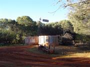
Mt Fisher Wanganoo Rd Near Wonganoo
Wiluna
Midwest
| Type | Status | Date | Documents |
|---|---|---|---|
| (no listings) |
| Type | Status | Date | Documents |
|---|---|---|---|
| (no listings) |
| Type | Status | Date | Grading/Management | |
|---|---|---|---|---|
| Category | ||||
| Mining Heritage Study | Adopted | 30 Jun 1999 | ||
Historic Site
| Epoch | General | Specific |
|---|---|---|
| Present Use | MINING | Mining Battery |
| Original Use | MINING | Mining Battery |
This information is provided voluntarily as a public service. The information provided is made available in good faith and is derived from sources believed to be reliable and accurate. However, the information is provided solely on the basis that readers will be responsible for making their own assessment of the matters discussed herein and are advised to verify all relevant representations, statements and information.
Pt Hedland to Ravensthorpe
Goes through the following LGAs: Port Hedland, East Pilbara, Wiluna, Meekatharra, Cue, Mt Magnet, Yalgoo, Sandstone, Menzies, Yilgarn, Ravensthorpe, Mt Marshall, Mukinbudin, Westonia, Merredin, Narembeen, Kondinin, Kulin, Lake Grace, Quairading
Cue
Midwest
Constructed from 1906
| Type | Status | Date | Documents |
|---|---|---|---|
| (no listings) |
| Type | Status | Date | Documents |
|---|---|---|---|
| RHP - To be assessed | Current | 25 Nov 2005 |
| Type | Status | Date | Grading/Management | |
|---|---|---|---|---|
| Category | ||||
| (no listings) | ||||
The place is the longest fence in the world, extending over 1800kms.
The place is significant for its contribution to agriculture at the turn of the century.
The place is rare as a method of pest control, that was to eventually also help prevent the movement of dingoes, foxes and emus.
The Rabbit Proof Fence is the longest fence in the world and cost £250 per kilometre to construct. It was made from Saltwater paperbark posts, wire netting 42 inches wide, with a mesh not less than 1 1/2 inches, and no lighter than 17 gauge, ‘b’ grade with barbed and plain wire. Six inches of the erected wire netting was buried in the ground.
Rabbits were introduced to Geelong from England by Thomas Austin in 1859. Towards the end of the last century rabbits were known to have travelled across to Western Australia from Victoria. In 1896, Arthur Gregory Mason reported that rabbits were at least two hundred miles past the South Australian border and inside Western Australia at the town of Eucla. His recommendation to the government was to build a rabbit proof fence. After much debate and a Royal Commission, the government eventually adopted the idea of a barrier fence. In 1901 the Government Surveyor, A.W. Canning was commissioned to survey a fence line to be built to cut off the flow of rabbits entering Western Australia. Canning with only Hubert Trotman, Hassan (an Afghan Camel man) and eight camels completed the preliminary exploratory survey from Burracoppin to Starvation Boat Harbour in July and August that year. They surveyed a route for the fence and its construction began in December the same year. The fence from Starvation Boat Harbour to Burracoppin was built by contract with saltwater paperbark posts on the lower section obtained locally and other materials were shipped into starvation Boat Harbour. The fence was completed in 1906. When the fence was completed, it was the longest fence in the world, stretching from Starvation Boat Harbour, just west of Esperance in the south, to Wallal on the 80 Mile Beach in the northwest, a distance of 1822kms. Even before completion, the rabbits were past the fence and work had begun on Fences No.2 and 3. By 1908 the three fences were complete, over 3,000km of fence line in total. (See map.) Although the construction of the fences was finished, someone was needed to patrol and maintain them. Alex Crawford was appointed the first Chief Inspector of Rabbits and was required to inspect and maintain the fences. The fence was maintained by boundary riders patrolling 240km stretches of fence line with an ingenuous permanent water catchments and huts at regular intervals of 50kms. There were gates at every 32kms and trap yards for foxes and dingoes as well as rabbits every 8 kms. Grids and rabbit proof gates were constructed where the fence crossed the road. Without regular water, the use of horses to carry out the fence inspection was difficult. When camels were used, it was found that inspection of the fence was unsatisfactory from the height of a camel. Many other methods were tried such as bicycles, but this proved unsatisfactory. In 1910, a motor vehicle was purchased to carry out the inspection but was also to prove unsatisfactory. After many punctures and broken springs, it had to be towed slowly back to camp by camels. In the end the only workable solution for the inspection teams were buckboard buggies pulled by pairs of camels. Despite the best efforts to stop the rabbits at the barrier fence, it was to only slow the rabbit's migration. Erosion under the fences, holes in the wire and gates left open allowed rabbits to continue their movement west into the fertile agricultural areas. In their hundreds of thousands, they ate out pasture, ring-barked trees and devoured crops. Much of the fence is still in good repair, especially where it is used by abutting farmers as a boundary fence.
Integrity- Moderate Authenticity- High
Good - although condition varies along the route
Historic site
| Epoch | General | Specific |
|---|---|---|
| Original Use | FARMING\PASTORAL | Other |
| Present Use | FARMING\PASTORAL | Other |
| Type | General | Specific |
|---|---|---|
| Wall | METAL | Other Metal |
| General | Specific |
|---|---|
| PEOPLE | Early settlers |
This information is provided voluntarily as a public service. The information provided is made available in good faith and is derived from sources believed to be reliable and accurate. However, the information is provided solely on the basis that readers will be responsible for making their own assessment of the matters discussed herein and are advised to verify all relevant representations, statements and information.
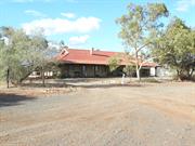
Well 9 Canning Stock Rte Weld Springs
Weld Springs- 230km NE of Wiluna
Wiluna
Midwest
| Type | Status | Date | Documents |
|---|---|---|---|
| (no listings) |
| Type | Status | Date | Documents |
|---|---|---|---|
| (no listings) |
| Type | Status | Date | Grading/Management | |
|---|---|---|---|---|
| Category | ||||
| Municipal Inventory | Adopted | 20 Oct 1995 | ||
Historic Site
| Epoch | General | Specific |
|---|---|---|
| Original Use | Transport\Communications | Rail: Other |
| Present Use | VACANT\UNUSED | Vacant\Unused |
| Type | General | Specific |
|---|---|---|
| Wall | STONE | Local Stone |
This information is provided voluntarily as a public service. The information provided is made available in good faith and is derived from sources believed to be reliable and accurate. However, the information is provided solely on the basis that readers will be responsible for making their own assessment of the matters discussed herein and are advised to verify all relevant representations, statements and information.
Constructed from 1874
This information is provided voluntarily as a public service. The information provided is made available in good faith and is derived from sources believed to be reliable and accurate. However, the information is provided solely on the basis that readers will be responsible for making their own assessment of the matters discussed herein and are advised to verify all relevant representations, statements and information.
Canning Stock Rte Weld Springs 230 k NE of Wiluna
230 km ne of Wiluna on Canning Stock Rte
Well 9, Canning Stock Route
Wiluna
Midwest
Constructed from 1874
| Type | Status | Date | Documents |
|---|---|---|---|
| (no listings) |
| Type | Status | Date | Documents |
|---|---|---|---|
| (no listings) |
| Type | Status | Date | Grading/Management | |
|---|---|---|---|---|
| Category | ||||
| Register of the National Estate | Registered | 21 Mar 1978 | ||
| Classified by the National Trust | Classified | 11 Feb 2002 | ||
05518 Canning Stock Route
Historic Site
| Epoch | General | Specific |
|---|---|---|
| Present Use | VACANT\UNUSED | Vacant\Unused |
| Original Use | Transport\Communications | Road: Other |
| Type | General | Specific |
|---|---|---|
| Wall | STONE | Local Stone |
This information is provided voluntarily as a public service. The information provided is made available in good faith and is derived from sources believed to be reliable and accurate. However, the information is provided solely on the basis that readers will be responsible for making their own assessment of the matters discussed herein and are advised to verify all relevant representations, statements and information.
Wiluna
Wiluna
Midwest
| Type | Status | Date | Documents |
|---|---|---|---|
| (no listings) |
| Type | Status | Date | Documents |
|---|---|---|---|
| (no listings) |
| Type | Status | Date | Grading/Management | |
|---|---|---|---|---|
| Category | ||||
| Municipal Inventory | Adopted | 20 Oct 1995 | ||
Historic site
| Epoch | General | Specific |
|---|---|---|
| Present Use | FARMING\PASTORAL | Other |
| Original Use | FARMING\PASTORAL | Other |
| General | Specific |
|---|---|
| OCCUPATIONS | Grazing, pastoralism & dairying |
| TRANSPORT & COMMUNICATIONS | Droving |
This information is provided voluntarily as a public service. The information provided is made available in good faith and is derived from sources believed to be reliable and accurate. However, the information is provided solely on the basis that readers will be responsible for making their own assessment of the matters discussed herein and are advised to verify all relevant representations, statements and information.
| Owner | Category |
|---|---|
| Lake Violet Station | Other Private |
This information is provided voluntarily as a public service. The information provided is made available in good faith and is derived from sources believed to be reliable and accurate. However, the information is provided solely on the basis that readers will be responsible for making their own assessment of the matters discussed herein and are advised to verify all relevant representations, statements and information.
Wiluna
Wiluna
Midwest
| Type | Status | Date | Documents |
|---|---|---|---|
| (no listings) |
| Type | Status | Date | Documents |
|---|---|---|---|
| (no listings) |
| Type | Status | Date | Grading/Management | |
|---|---|---|---|---|
| Category | ||||
| Municipal Inventory | Adopted | 20 Oct 1995 | ||
Historic Site
| Epoch | General | Specific |
|---|---|---|
| Present Use | COMMERCIAL | Hotel, Tavern or Inn |
| Original Use | COMMERCIAL | Hotel, Tavern or Inn |
| General | Specific |
|---|---|
| SOCIAL & CIVIC ACTIVITIES | Sport, recreation & entertainment |
This information is provided voluntarily as a public service. The information provided is made available in good faith and is derived from sources believed to be reliable and accurate. However, the information is provided solely on the basis that readers will be responsible for making their own assessment of the matters discussed herein and are advised to verify all relevant representations, statements and information.
| Owner | Category |
|---|---|
| Wongawol Pty Ltd | Other Private |
This information is provided voluntarily as a public service. The information provided is made available in good faith and is derived from sources believed to be reliable and accurate. However, the information is provided solely on the basis that readers will be responsible for making their own assessment of the matters discussed herein and are advised to verify all relevant representations, statements and information.
Wiluna
Wiluna
Midwest
| Type | Status | Date | Documents |
|---|---|---|---|
| (no listings) |
| Type | Status | Date | Documents |
|---|---|---|---|
| (no listings) |
| Type | Status | Date | Grading/Management | |
|---|---|---|---|---|
| Category | ||||
| Municipal Inventory | Adopted | 20 Oct 1995 | ||
Historic site
| Epoch | General | Specific |
|---|---|---|
| Original Use | FARMING\PASTORAL | Other |
| Present Use | FARMING\PASTORAL | Other |
| General | Specific |
|---|---|
| OCCUPATIONS | Grazing, pastoralism & dairying |
| TRANSPORT & COMMUNICATIONS | Droving |
This information is provided voluntarily as a public service. The information provided is made available in good faith and is derived from sources believed to be reliable and accurate. However, the information is provided solely on the basis that readers will be responsible for making their own assessment of the matters discussed herein and are advised to verify all relevant representations, statements and information.
Transport and Communications: Droving, Occupations: Well-sinking, Grazing
Site
This information is provided voluntarily as a public service. The information provided is made available in good faith and is derived from sources believed to be reliable and accurate. However, the information is provided solely on the basis that readers will be responsible for making their own assessment of the matters discussed herein and are advised to verify all relevant representations, statements and information.
Wiluna
Wiluna
Midwest
Constructed from 1959, Constructed from 1958
| Type | Status | Date | Documents |
|---|---|---|---|
| (no listings) |
| Type | Status | Date | Documents |
|---|---|---|---|
| (no listings) |
| Type | Status | Date | Grading/Management | |
|---|---|---|---|---|
| Category | ||||
| Municipal Inventory | Adopted | 20 Oct 1995 | ||
Other Built Type
| Epoch | General | Specific |
|---|---|---|
| Original Use | Transport\Communications | Road: Other |
| Present Use | Transport\Communications | Road: Other |
| General | Specific |
|---|---|
| TRANSPORT & COMMUNICATIONS | Road transport |
This information is provided voluntarily as a public service. The information provided is made available in good faith and is derived from sources believed to be reliable and accurate. However, the information is provided solely on the basis that readers will be responsible for making their own assessment of the matters discussed herein and are advised to verify all relevant representations, statements and information.
The Gunbarrel Highway has some significance as a transport route through the Shire of Wiluna. It has further historic significance for its association with the rocket launching bases in the late 1950s and 60s.
No access was gained to the road.
The Gunbarrel Highway was constructed in 1958-59 but was not named as such until a few years later, between 1959-64. It was built as a retrieval road for rockets fired from Woomera and Maralinga. The road was named after the road construction party who built it. Originally named as a joke by Len Beadell, "The Gunbarrel Road Construction Party" was so named because "wherever possible we liked to make our roads straight" (pi 8) The Highway is now an adventure route for 4WD enthusiasts.
This information is provided voluntarily as a public service. The information provided is made available in good faith and is derived from sources believed to be reliable and accurate. However, the information is provided solely on the basis that readers will be responsible for making their own assessment of the matters discussed herein and are advised to verify all relevant representations, statements and information.
Wiluna
Wiluna
Midwest
Constructed from 1902 to 1947
| Type | Status | Date | Documents |
|---|---|---|---|
| (no listings) |
| Type | Status | Date | Documents |
|---|---|---|---|
| (no listings) |
| Type | Status | Date | Grading/Management | |
|---|---|---|---|---|
| Category | ||||
| Municipal Inventory | Adopted | 20 Oct 1995 | ||
| Library Id | Title | Medium | Year Of Publication |
|---|---|---|---|
| 11546 | History of Wiluna | Electronic | 1963 |
Historic Site
| Epoch | General | Specific |
|---|---|---|
| Present Use | MINING | Other |
| Original Use | MINING | Other |
| General | Specific |
|---|---|
| DEMOGRAPHIC SETTLEMENT & MOBILITY | Resource exploitation & depletion |
| OCCUPATIONS | Mining {incl. mineral processing} |
This information is provided voluntarily as a public service. The information provided is made available in good faith and is derived from sources believed to be reliable and accurate. However, the information is provided solely on the basis that readers will be responsible for making their own assessment of the matters discussed herein and are advised to verify all relevant representations, statements and information.
Constructed from 1947, Constructed from 1902
The site of the Wiluna Gold Mine has high historic significance for its important role in the development of the district's mining industry.
The Wiluna Gold Mine commenced operations in 1902 and was worked very successfully until 1947. During its lifetime the mine changed hands twice. From 1902 until 1914 it was worked under the name of Gwalia Consolidated Ltd. From 1914 to 1924 it was known as the Western Machinery Company Ltd and from 1924 to its close in 1947 it was called the Wiluna Gold Mine Ltd. (pi3) The mine was at its peak in 1937-38 when it employed 1,028 men and was one of the largest producing mines in the State. (pl3) During the Second World War the mine was used in the production of arsenic and was consequently identified as a target by the Japanese, (pi 5) The mine closed due to decreasing values in its load formation.
| Ref ID No | Ref Name | Ref Source | Ref Date |
|---|---|---|---|
| Topperwein GH, "The History of Wiluna" |
This information is provided voluntarily as a public service. The information provided is made available in good faith and is derived from sources believed to be reliable and accurate. However, the information is provided solely on the basis that readers will be responsible for making their own assessment of the matters discussed herein and are advised to verify all relevant representations, statements and information.
Wiluna
Wiluna
Midwest
Constructed from 1934 to 1985
| Type | Status | Date | Documents |
|---|---|---|---|
| (no listings) |
| Type | Status | Date | Documents |
|---|---|---|---|
| RHP - Assessed - Below Threshold | Current | 31 Aug 2007 |
| Type | Status | Date | Grading/Management | |
|---|---|---|---|---|
| Category | ||||
| (no listings) | ||||
Fair condition
Individual Building or Group
| Epoch | General | Specific |
|---|---|---|
| Original Use | EDUCATIONAL | Combined School |
| Style |
|---|
| Vernacular |
| Type | General | Specific |
|---|---|---|
| Roof | METAL | Corrugated Iron |
| Wall | ASBESTOS | Fibrous Cement, flat |
| General | Specific |
|---|---|
| SOCIAL & CIVIC ACTIVITIES | Institutions |
| PEOPLE | Aboriginal people |
| DEMOGRAPHIC SETTLEMENT & MOBILITY | Settlements |
| OCCUPATIONS | Mining {incl. mineral processing} |
| DEMOGRAPHIC SETTLEMENT & MOBILITY | Aboriginal Occupation |
| SOCIAL & CIVIC ACTIVITIES | Education & science |
| OUTSIDE INFLUENCES | Depression & boom |
| SOCIAL & CIVIC ACTIVITIES | Community services & utilities |
This information is provided voluntarily as a public service. The information provided is made available in good faith and is derived from sources believed to be reliable and accurate. However, the information is provided solely on the basis that readers will be responsible for making their own assessment of the matters discussed herein and are advised to verify all relevant representations, statements and information.
Wiluna
Wiluna
Midwest
Constructed from 1996
| Type | Status | Date | Documents |
|---|---|---|---|
| (no listings) |
| Type | Status | Date | Documents |
|---|---|---|---|
| (no listings) |
| Type | Status | Date | Grading/Management | |
|---|---|---|---|---|
| Category | ||||
| Statewide War Memorial Survey | Completed | 01 May 1996 | ||
Historic site
| Epoch | General | Specific |
|---|---|---|
| Present Use | MONUMENT\CEMETERY | Monument |
| Original Use | MONUMENT\CEMETERY | Monument |
| Type | General | Specific |
|---|---|---|
| Other | METAL | Bronze |
| Other | STONE | Local Stone |
| General | Specific |
|---|---|
| OUTSIDE INFLUENCES | World Wars & other wars |
This information is provided voluntarily as a public service. The information provided is made available in good faith and is derived from sources believed to be reliable and accurate. However, the information is provided solely on the basis that readers will be responsible for making their own assessment of the matters discussed herein and are advised to verify all relevant representations, statements and information.
Situated 2 km SE of Wiluna
The Lodge
Wiluna
Midwest
Constructed from 1929
| Type | Status | Date | Documents |
|---|---|---|---|
| State Register | Registered | 27 Dec 2002 | HCWebsite.Listing+ListingDocument, HCWebsite.Listing+ListingDocument |
| Type | Status | Date | Documents |
|---|---|---|---|
| (no listings) |
| Type | Status | Date | Grading/Management | |
|---|---|---|---|---|
| Category | ||||
| Municipal Inventory | Adopted | 20 Oct 1995 | ||
02740 Wiluna Mine (fmr) (Site)
Wade Johnston (owner rep(9981 7184)) reported condition of mud-brick poor
| Name | Type | Year From | Year To |
|---|---|---|---|
| C E Prior | Architect | - | 2002 |
| Library Id | Title | Medium | Year Of Publication |
|---|---|---|---|
| 5601 | Images CD No. 1 | C D Rom | 2002 |
| 5239 | The Lodge, Red Hill, Wiluna : conservation plan / prepared for Normandy Mining Limited by Considine & Griffiths Architects ; with Robin Chinnery. | Heritage Study {Cons'n Plan} | 2001 |
| 6316 | Mine Manager's House, Redhill, Wiluna : conservation works. | Conservation works report | 2003 |
| 11546 | History of Wiluna | Electronic | 1963 |
Individual Building or Group
| Epoch | General | Specific |
|---|---|---|
| Present Use | MINING | Housing or Quarters |
| Original Use | MINING | Housing or Quarters |
| Style |
|---|
| Federation Bungalow |
| Inter-War Old English |
| Type | General | Specific |
|---|---|---|
| Roof | METAL | Corrugated Iron |
| Wall | EARTH | Adobe {Mud Brick} |
| Other | TIMBER | Other Timber |
| General | Specific |
|---|---|
| OCCUPATIONS | Mining {incl. mineral processing} |
This information is provided voluntarily as a public service. The information provided is made available in good faith and is derived from sources believed to be reliable and accurate. However, the information is provided solely on the basis that readers will be responsible for making their own assessment of the matters discussed herein and are advised to verify all relevant representations, statements and information.
Constructed from 1929
The former mine manager's house has some historic significance for its association with the Wiluna Gold Mine.
| Owner | Category |
|---|---|
| Wiluna Gold | Other Private |
This information is provided voluntarily as a public service. The information provided is made available in good faith and is derived from sources believed to be reliable and accurate. However, the information is provided solely on the basis that readers will be responsible for making their own assessment of the matters discussed herein and are advised to verify all relevant representations, statements and information.
Canning Stock Rte Wiluna
Wiluna
Midwest
| Type | Status | Date | Documents |
|---|---|---|---|
| (no listings) |
| Type | Status | Date | Documents |
|---|---|---|---|
| (no listings) |
| Type | Status | Date | Grading/Management | |
|---|---|---|---|---|
| Category | ||||
| Register of the National Estate | Registered | 21 Mar 1978 | ||
05518 Canning Stock Route
Landscape
| Epoch | General | Specific |
|---|---|---|
| Original Use | PARK\RESERVE | Park\Reserve |
| General | Specific |
|---|---|
| DEMOGRAPHIC SETTLEMENT & MOBILITY | Exploration & surveying |
This information is provided voluntarily as a public service. The information provided is made available in good faith and is derived from sources believed to be reliable and accurate. However, the information is provided solely on the basis that readers will be responsible for making their own assessment of the matters discussed herein and are advised to verify all relevant representations, statements and information.
Earaheedy Station Wiluna
Wiluna
Midwest
| Type | Status | Date | Documents |
|---|---|---|---|
| (no listings) |
| Type | Status | Date | Documents |
|---|---|---|---|
| (no listings) |
| Type | Status | Date | Grading/Management | |
|---|---|---|---|---|
| Category | ||||
| (no listings) | ||||
| Library Id | Title | Medium | Year Of Publication |
|---|---|---|---|
| 9595 | The Department of Environment and Conservation's management of former pastoral leases. | Electronic | 2010 |
Individual Building or Group
| Epoch | General | Specific |
|---|---|---|
| Present Use | VACANT\UNUSED | Vacant\Unused |
| Original Use | FARMING\PASTORAL | Servants or Shearers Quarters |
This information is provided voluntarily as a public service. The information provided is made available in good faith and is derived from sources believed to be reliable and accurate. However, the information is provided solely on the basis that readers will be responsible for making their own assessment of the matters discussed herein and are advised to verify all relevant representations, statements and information.
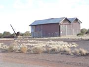
Forrest St Wiluna
Wiluna
Midwest
Constructed from 1930
| Type | Status | Date | Documents |
|---|---|---|---|
| (no listings) |
| Type | Status | Date | Documents |
|---|---|---|---|
| (no listings) |
| Type | Status | Date | Grading/Management | |
|---|---|---|---|---|
| Category | ||||
| Municipal Inventory | Adopted | 20 Oct 1995 | ||
| Library Id | Title | Medium | Year Of Publication |
|---|---|---|---|
| 3457 | Railway Goods Shed Shire of Wiluna - Final Project for Restoration Project | Heritage Study {Other} | 1998 |
Individual Building or Group
| Epoch | General | Specific |
|---|---|---|
| Original Use | Transport\Communications | Rail: Other |
| Present Use | COMMERCIAL | Warehouse |
| Type | General | Specific |
|---|---|---|
| Roof | METAL | Corrugated Iron |
| Wall | METAL | Corrugated Iron |
| General | Specific |
|---|---|
| TRANSPORT & COMMUNICATIONS | Rail & light rail transport |
This information is provided voluntarily as a public service. The information provided is made available in good faith and is derived from sources believed to be reliable and accurate. However, the information is provided solely on the basis that readers will be responsible for making their own assessment of the matters discussed herein and are advised to verify all relevant representations, statements and information.
Constructed from 1930
The Railway Goods Shed has high historic significance for its association with the railway line between Meekatharra and Wiluna. The place has further significance given that it is one of the last remaining relics of the railway in the Wiluna district. The Goods Shed is representative, in both form and materials, of the type of industrial structure used for storage.
This large timber framed shed is clad with corrugated iron and features a double gabled roof line. The building has openings to the north and south elevations where the train carriages passed through. The structure features metal louvred vents in gable ends and skylights. The railway crane stands adjacent.
In 1927 Parliament gave approval for the construction of the railway line between Meekatharra and Wiluna. Construction commenced in March, 1929. The Goods Shed was probably built cl930. The railway line closed on 5 August, 1957. While other heritage buildings were being demolished by the Wiluna Council in 1990, this shed was saved by pressure from members of the Wiluna Historical and Heritage Preservation Society.
High
fair
| Ref ID No | Ref Name | Ref Source | Ref Date |
|---|---|---|---|
| Topperwein GH, "The History of Wiluna". | |||
| Quartermaine MK, "Notes" 9/8/1995 | 9/8/1995 |
| Owner | Category |
|---|---|
| Wiluna Historical & Heritage Society | Inc. Non-profit body |
This information is provided voluntarily as a public service. The information provided is made available in good faith and is derived from sources believed to be reliable and accurate. However, the information is provided solely on the basis that readers will be responsible for making their own assessment of the matters discussed herein and are advised to verify all relevant representations, statements and information.
Jones St Wiluna
Wiluna
Midwest
| Type | Status | Date | Documents |
|---|---|---|---|
| (no listings) |
| Type | Status | Date | Documents |
|---|---|---|---|
| (no listings) |
| Type | Status | Date | Grading/Management | |
|---|---|---|---|---|
| Category | ||||
| Municipal Inventory | Adopted | 20 Oct 1995 | ||
Individual Building or Group
| Epoch | General | Specific |
|---|---|---|
| Present Use | VACANT\UNUSED | Vacant\Unused |
| Original Use | MINING | Mining Battery |
| General | Specific |
|---|---|
| OCCUPATIONS | Mining {incl. mineral processing} |
This information is provided voluntarily as a public service. The information provided is made available in good faith and is derived from sources believed to be reliable and accurate. However, the information is provided solely on the basis that readers will be responsible for making their own assessment of the matters discussed herein and are advised to verify all relevant representations, statements and information.
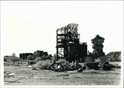
The former State Battery has high historic significance for its crucial role in the district's mining industry. Although little remains of the structure, the site should be appropriately recognised.
Located immediately east of the town and adjacent to the former hospital, all that remains of the State Battery are foundations, some building materials and rusty equipment. Nearby are the present mining workings.
On 2 February, 1904 the State Battery was opened. It was located adjacent to the east boundary of the early townsite. The Battery would have received much use from the time it was constructed until the late 1940s when the Wiluna Gold Mine closed. From 1904 to 1950 the State Battery treated 102,849 tons for 52,260 bullion ounces. From 1915 to 1930, when the Battery also had a ball mill and cyanide vats, 82,979 tons were treated for 34,540 bullion ounces.
poor
| Ref ID No | Ref Name | Ref Source | Ref Date |
|---|---|---|---|
| Quartermaine MK "etc | 9/8/1995 | ||
| Topperwein GH " ..etc |
| Owner | Category |
|---|---|
| unknown | UNKNOWN |
This information is provided voluntarily as a public service. The information provided is made available in good faith and is derived from sources believed to be reliable and accurate. However, the information is provided solely on the basis that readers will be responsible for making their own assessment of the matters discussed herein and are advised to verify all relevant representations, statements and information.
Jones St Wiluna
Wiluna
Midwest
Constructed from 1904
| Type | Status | Date | Documents |
|---|---|---|---|
| (no listings) |
| Type | Status | Date | Documents |
|---|---|---|---|
| (no listings) |
| Type | Status | Date | Grading/Management | |
|---|---|---|---|---|
| Category | ||||
| (no listings) | ||||
Historic Site
| Epoch | General | Specific |
|---|---|---|
| Original Use | MINING | Mining Battery |
| Present Use | VACANT\UNUSED | Vacant\Unused |
| General | Specific |
|---|---|
| OCCUPATIONS | Mining {incl. mineral processing} |
This information is provided voluntarily as a public service. The information provided is made available in good faith and is derived from sources believed to be reliable and accurate. However, the information is provided solely on the basis that readers will be responsible for making their own assessment of the matters discussed herein and are advised to verify all relevant representations, statements and information.
19 Lennon St Wiluna
Wiluna Agricultural Research Station
Wiluna
Midwest
Constructed from 1936
| Type | Status | Date | Documents |
|---|---|---|---|
| (no listings) |
| Type | Status | Date | Documents |
|---|---|---|---|
| (no listings) |
| Type | Status | Date | Grading/Management | |
|---|---|---|---|---|
| Category | ||||
| Municipal Inventory | Adopted | 20 Oct 1995 | ||
Historic Site
| Epoch | General | Specific |
|---|---|---|
| Original Use | COMMERCIAL | Hotel, Tavern or Inn |
| Present Use | COMMERCIAL | Hotel, Tavern or Inn |
| General | Specific |
|---|---|
| OCCUPATIONS | Hospitality industry & tourism |
| SOCIAL & CIVIC ACTIVITIES | Sport, recreation & entertainment |
This information is provided voluntarily as a public service. The information provided is made available in good faith and is derived from sources believed to be reliable and accurate. However, the information is provided solely on the basis that readers will be responsible for making their own assessment of the matters discussed herein and are advised to verify all relevant representations, statements and information.
Constructed from 1936
The site of the Lake Way Hotel has some social and historic significance as the place where one of Wiluna's hotels was located. In its day it was considered to be very grand.
On 8 November, 1935 James Hayes applied for and was granted a Provisional Certificate of Licence to erect "sample rooms for commercial travellers". (The Wiluna Miner, 8/11/1935, p6) The following month T. W. Lees was contracted to build the architect designed Lake Way Hotel. (The Wiluna Miner, 17/1/1936, p2 & 14/2/1936, p6) Built away from the main shopping area, a local newspaper of the time stated that: "On completion of the hotel and the hostel on an adjacent block Wiluna's architectural beauty will be enhanced." (The Wiluna Miner, 20/3/1936, p2) The name of the hotel corresponded with the name by which Wiluna was originally known "Lake Way". The Hotel was officially opened for business in July 1936 and The Wiluna Miner recorded the event: "The public bar has a counter space of 114 feet...The residential accommodation rivals that of the leading city hotels and has no peer in the country. There are 31 bedrooms...spacious lounges have been provided...each lounge has access to the writing room which is elaborately fumished...carefully arranged sitting room...the balconies facing Wall and Lennon Streets are exceptionally spacious...the dining room will seat 70 to 80 guests..." (3/7/1936, p3) The Hotel, which was of brick and tile construction, also featured many modem conveniences of the period including a substantial refrigeration system and a wireless system wired throughout the building with controls in each room. The Hotel cost 26,000 pounds to build and a total of40,000 pounds fully furnished. When it was built it is said that a whole trainload of tiles arrived just for the one building. Indeed, it was the only building in the town with a tiled roof at the time. (Topperwien, p.22) James Hayes, who had a long association with the hotel trade in Sandstone, Meekatharra and other centres, owned the Hotel until 1939. F.R. Mann owned the Hotel from 1939 to 1941 when A. Wantling took over until 1947. (Wise's, Post Office Directory) The Agricultural Department purchased the Lake Way Hotel in 1957 to house the workers at the Wiluna Agricultural Research Station. (Topperwien, p27 & Minutes of the Wiluna Road Board, AN296/1, Acc 1313, Item 12) The hotel was demolished in the 1980s.
| Ref ID No | Ref Name | Ref Source | Ref Date |
|---|---|---|---|
| Topperwein GH "The History of Wiluna". p.27 | |||
| "Newspaper Article" | The Wiluna Miner |
| Owner | Category |
|---|---|
| Ngangganawili | Other Private |
This information is provided voluntarily as a public service. The information provided is made available in good faith and is derived from sources believed to be reliable and accurate. However, the information is provided solely on the basis that readers will be responsible for making their own assessment of the matters discussed herein and are advised to verify all relevant representations, statements and information.
Red Hill Wiluna
southern portion of townsite
residential suburb (fmr)
Wiluna
Midwest
Constructed from 1935
| Type | Status | Date | Documents |
|---|---|---|---|
| (no listings) |
| Type | Status | Date | Documents |
|---|---|---|---|
| (no listings) |
| Type | Status | Date | Grading/Management | |
|---|---|---|---|---|
| Category | ||||
| Municipal Inventory | Adopted | 20 Oct 1995 | ||
Historic Town or district
| Epoch | General | Specific |
|---|---|---|
| Original Use | RESIDENTIAL | Other |
| Present Use | RESIDENTIAL | Other |
| General | Specific |
|---|---|
| DEMOGRAPHIC SETTLEMENT & MOBILITY | Settlements |
This information is provided voluntarily as a public service. The information provided is made available in good faith and is derived from sources believed to be reliable and accurate. However, the information is provided solely on the basis that readers will be responsible for making their own assessment of the matters discussed herein and are advised to verify all relevant representations, statements and information.
Constructed from 1935
The remains of the residential suburb of Red Hill are historically significant as they are evidence of the former size of the Wiluna townsite. There are similar remains to the west of the present town which also assist with an understanding of the scale of the town in its heyday.
All that remains of this once prestigious suburb are building foundations, rusty equipment and evidence of laid out gardens over a large area of land.
Situated south of the hospital, the suburb of Red Hill emerged during the 1930s and was home to married workers. (M.K. Quartermaine notes, 9/8/1995) The suburb was named after a hill located immediately north, "Red Hill".
This information is provided voluntarily as a public service. The information provided is made available in good faith and is derived from sources believed to be reliable and accurate. However, the information is provided solely on the basis that readers will be responsible for making their own assessment of the matters discussed herein and are advised to verify all relevant representations, statements and information.