Local Government
Yalgoo
Region
Midwest
Dalgaranga - Meteorite Rd Dalgaranga Station
31.5km from homestead
Yalgoo
Midwest
| Type | Status | Date | Documents |
|---|---|---|---|
| (no listings) |
| Type | Status | Date | Documents |
|---|---|---|---|
| (no listings) |
| Type | Status | Date | Grading/Management | |
|---|---|---|---|---|
| Category | ||||
| Register of the National Estate | Registered | 30 Jun 1992 | ||
| Register of the National Estate | Nominated | 01 Aug 1990 | ||
| Classified by the National Trust | Classified {Lscpe} | |||
| Library Id | Title | Medium | Year Of Publication |
|---|---|---|---|
| 2398 | National Estate Program : documentation of geological sites and monuments; Nomination of geological monument for the register of the National Estate: Dingo Gap, Bugle Gap, Bringo Railway cutting, Molecap Hill, Veevers Crater, Dalgaranga Crater, North Pole, | Report | 1989 |
Geological monument
| Epoch | General | Specific |
|---|---|---|
| Original Use | OTHER | Other |
| Present Use | OTHER | Other |
This information is provided voluntarily as a public service. The information provided is made available in good faith and is derived from sources believed to be reliable and accurate. However, the information is provided solely on the basis that readers will be responsible for making their own assessment of the matters discussed herein and are advised to verify all relevant representations, statements and information.
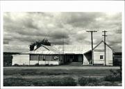
Melangata Rd Melangata
Malangata Station
Yalgoo
Midwest
Constructed from 1916
| Type | Status | Date | Documents |
|---|---|---|---|
| State Register | Registered | 30 Oct 1998 | HCWebsite.Listing+ListingDocument, HCWebsite.Listing+ListingDocument |
| Type | Status | Date | Documents |
|---|---|---|---|
| (no listings) |
| Type | Status | Date | Grading/Management | |
|---|---|---|---|---|
| Category | ||||
| Municipal Inventory | Adopted | 19 Jun 1996 | Category 1 | |
| Classified by the National Trust | Classified | 02 Sep 1985 | ||
| Register of the National Estate | Indicative Place | |||
| Name | Type | Year From | Year To |
|---|---|---|---|
| Mons J C Hawes | Architect | - | - |
| Library Id | Title | Medium | Year Of Publication |
|---|---|---|---|
| 9287 | Melangata homestead Yalgoo Western Australia. Proposed restoration works. | Conservation works report | 2009 |
| 6644 | Conservation works to Melangata Homestead via Yalgoo. | Conservation works report | 2003 |
| 3901 | Final Report on 1998-99 Conservation Works-Chapel and Lounge Melangata Homestead | Heritage Study {Other} | 1999 |
| 3526 | Conservation Plan for the Melangata Homestead Melangata Station, Shire of Yalgoo Western Australia | Heritage Study {Cons'n Plan} | 1998 |
Individual Building or Group
| Epoch | General | Specific |
|---|---|---|
| Original Use | FARMING\PASTORAL | Homestead |
| Present Use | FARMING\PASTORAL | Homestead |
| Style |
|---|
| Inter-War Romanesque |
| Type | General | Specific |
|---|---|---|
| Roof | METAL | Corrugated Iron |
| Wall | STONE | Other Stone |
| General | Specific |
|---|---|
| OCCUPATIONS | Grazing, pastoralism & dairying |
This information is provided voluntarily as a public service. The information provided is made available in good faith and is derived from sources believed to be reliable and accurate. However, the information is provided solely on the basis that readers will be responsible for making their own assessment of the matters discussed herein and are advised to verify all relevant representations, statements and information.
Constructed from 1917
The Melangata Station Homestead has historic significance for its role in the development of the pastoral industry in the Yalgoo district. It has further significance as a rare example of the work of Priest- Architect Monsignor John Hawes in the field of domestic architecture. Melangata Station has both aesthetic and rarity value for the handpainted pressed metal ceilings which are also a feature of the Noongal Station Homestead [Place 22] and Carlaminda Station Homestead. [Place 23] The chapel, tower, and breezeway also contribute to the aesthetic significance of the place.
The Melangata Station Homestead is a stone building with a corrugated iron roof and surrounding verandahs. It features a stone tower which has several large cracks visible and a chapel which opens off the living room. There is a breezeway between the living and sleeping quarters. The living room features pressed metal ceilings handpainted by H.C. Jermy.
Although pastoral leases of the majority of land surrounding Melangata were taken up before 1880, the area on which the homestead is located was not leased until 1897. For about twenty years the only dwelling on the property was a simple humpy at an outcamp by the Cue Road which passed through the Melangata pastoral lease. cl915 C.C. Williamson became the owner of the station and cl917 the present house was completed. The house was designed by Father J.C. Hawes, whose parish included Yalgoo at that time. Hawes also supervised the erection of the building which is his only non -ecclesiastical building in Western Australia. [A. Palmer, Yalgoo, p148-150]
| Ref ID No | Ref Name | Ref Source | Ref Date |
|---|---|---|---|
| A Palmer; "Yalgoo". p.148-150 | 1985 |
| Owner | Category |
|---|---|
| OMT & R Seaman | Other Private |
This information is provided voluntarily as a public service. The information provided is made available in good faith and is derived from sources believed to be reliable and accurate. However, the information is provided solely on the basis that readers will be responsible for making their own assessment of the matters discussed herein and are advised to verify all relevant representations, statements and information.
Northampton to Ravensthorpe
Goes thro following LGAs: Northampton, Yalgoo, Perenjori, Dalwallinu, Wongan-Ballidu, Koorda, Dowerin, Cunderdin, Tammin, Quairading, Corrigin, Wickepin, Kulin, Dumbleyung, Kent, Gnowangerup, Jerramungup, Ravensthorpe. Almost parallel with No 1 Fence, 100 km or so further west.
Emu Barrier Fence
Corrigin
Wheatbelt
Constructed from 1906 to 1908
| Type | Status | Date | Documents |
|---|---|---|---|
| (no listings) |
| Type | Status | Date | Documents |
|---|---|---|---|
| RHP - Does not warrant assessment | Current | 25 Nov 2005 |
| Type | Status | Date | Grading/Management | |
|---|---|---|---|---|
| Category | ||||
| Municipal Inventory | Adopted | 17 Oct 2002 | Category D | |
Good - although it varies along the route
Other Built Type
| Epoch | General | Specific |
|---|---|---|
| Original Use | GOVERNMENTAL | Other |
| Present Use | GOVERNMENTAL | Other |
| Type | General | Specific |
|---|---|---|
| Other | METAL | Other Metal |
| General | Specific |
|---|---|
| OCCUPATIONS | Rural industry & market gardening |
| SOCIAL & CIVIC ACTIVITIES | Government & politics |
This information is provided voluntarily as a public service. The information provided is made available in good faith and is derived from sources believed to be reliable and accurate. However, the information is provided solely on the basis that readers will be responsible for making their own assessment of the matters discussed herein and are advised to verify all relevant representations, statements and information.
Constructed from 1907
The Rabbit Proof Fence has historic and representative cultural heritage significance. The Fence was a major attempt by the WA Government to prevent the pestilence of rabbits, an introduced animal to Australia. The Rabbit Proof Fence No.2 divides the Shire of Dumbleyung and has had a marked influence on the history of land development in the region. Names of roads in the district east of Dumbleyung reflect the effect of the Fence with Fence Rd and 125 Gate Rd being two examples. The fence, though extremely long and crossing many Local Government Areas throughout WA, had a particularly strong influence over land development patterns in Dumbleyung and is representative of early government attempts to help sustain agriculture.
In the late 19th century rabbits which were not established in WA, were recognised as a possible menace to agriculture. The rabbits were travelling from the eastern seaboard at a rate of 35 miles a year and the Western Australian Government formed a plan to try and prevent the pests entry. A decision was made to construct a rabbit proof fence from the 80 Mile Beach in the north, through the Great Sandy Desert to end at Starvation Beach near Esperance in the south. When Rabbit Proof Fence Number One was completed in 1903, it was the longest unbroken line of fence in the world. However, on its completion rabbits had already appeared west of the barrier. Another fence was therefore hurriedly erected roughly 60 miles parallel inside the first. It was built in the period between March and July 1904. The fence was constructed of jam posts placed 12 feet apart with wire netting of which the lowest 6 inches were dipped in coal tar and buried (towards the east) to prevent the rabbits from digging under. A wide clearing either side provided for a fire break and access for boundary riders. The second fence built divided the Dumbleyung district. The fence was kept in order by Government employees. Riders were employed to check the fence, using bicycles for transport. Gates in the fence needed to be opened and closed each time and location was often determined by the gate number (eg. 125 Gate Rd). The many gates made collection of water difficult for some farmers who had to travel many miles to a water supply. The first rabbit proof fence was abandoned in 1916 when it was obvious it had failed and that more time was needed maintaining the second fence. By the 1940s it was realised that the rabbit proof fence had failed but the gates were still patrolled and fines were issued if left open. This vigilance was maintained into the 1950s In 1959 the Rabbit Proof Fence Department was finally disbanded and the gates were left permanently open. At the same time myxomatosis was introduced which greatly reduced the rabbit population. Today the rabbit proof fence is still referred to as 'the fence'. Though no longer a physical divide, people still talk in terms of their community being east or west of the fence.
| Ref ID No | Ref Name | Ref Source | Ref Date |
|---|---|---|---|
| J Timperley; "Beyond the Fence: A History of Kukerin, Moluyinning and Nearby Communities". | 1996 | ||
| O'Brien Planning Consultants; "Municipal Heritage Inventory". | Shire of Dumbleyung | 1998 |
This information is provided voluntarily as a public service. The information provided is made available in good faith and is derived from sources believed to be reliable and accurate. However, the information is provided solely on the basis that readers will be responsible for making their own assessment of the matters discussed herein and are advised to verify all relevant representations, statements and information.
Paynes Find
Yalgoo
Midwest
| Type | Status | Date | Documents |
|---|---|---|---|
| (no listings) |
| Type | Status | Date | Documents |
|---|---|---|---|
| (no listings) |
| Type | Status | Date | Grading/Management | |
|---|---|---|---|---|
| Category | ||||
| Municipal Inventory | Adopted | 19 Jun 1996 | Category 3 | |
Historic site
| Epoch | General | Specific |
|---|---|---|
| Original Use | GOVERNMENTAL | Other |
| Present Use | GOVERNMENTAL | Other |
| Type | General | Specific |
|---|---|---|
| Wall | STONE | Other Stone |
| General | Specific |
|---|---|
| DEMOGRAPHIC SETTLEMENT & MOBILITY | Settlements |
This information is provided voluntarily as a public service. The information provided is made available in good faith and is derived from sources believed to be reliable and accurate. However, the information is provided solely on the basis that readers will be responsible for making their own assessment of the matters discussed herein and are advised to verify all relevant representations, statements and information.
Mullegee Well has historic and social significance as a valuable water supply for the district. If verified, the fact it was built by monks adds a historic association.
Mullegee Well is a round stone lined well with no windmill.
Mullegee Well is said to have been built by monks.
Poor
This information is provided voluntarily as a public service. The information provided is made available in good faith and is derived from sources believed to be reliable and accurate. However, the information is provided solely on the basis that readers will be responsible for making their own assessment of the matters discussed herein and are advised to verify all relevant representations, statements and information.

Lot 4234 Great Northern Hwy Paynes Find
Paynes Find Tavern
Yalgoo
Midwest
Constructed from 1914 to 1930
| Type | Status | Date | Documents |
|---|---|---|---|
| (no listings) |
| Type | Status | Date | Documents |
|---|---|---|---|
| (no listings) |
| Type | Status | Date | Grading/Management | |
|---|---|---|---|---|
| Category | ||||
| Statewide Hotel Survey | Completed | 01 Nov 1997 | ||
| Municipal Inventory | YES | 19 Jun 1996 | Category 2 | |
Individual Building or Group
| Epoch | General | Specific |
|---|---|---|
| Original Use | COMMERCIAL | Hotel, Tavern or Inn |
| Present Use | COMMERCIAL | Hotel, Tavern or Inn |
| Type | General | Specific |
|---|---|---|
| Wall | STONE | Other Stone |
| Roof | METAL | Corrugated Iron |
| General | Specific |
|---|---|
| OCCUPATIONS | Hospitality industry & tourism |
This information is provided voluntarily as a public service. The information provided is made available in good faith and is derived from sources believed to be reliable and accurate. However, the information is provided solely on the basis that readers will be responsible for making their own assessment of the matters discussed herein and are advised to verify all relevant representations, statements and information.
Constructed from 1914, Constructed from 1930
The Paynes Find Tavern has historic and social significance for the development of the Paynes Find district. The built fabric of the place is evidence of the changes since the original corrugated iron structure was erected.
The building is a single storey structure, originally timber framed and clad with corrugated iron sheeting. The front wall (north elevation) is constructed of stone and mud mortar with corner brick quoin surrounds and was added c 1930s. The place features pressed tin internal wall linings. An old hand operated Neptune petrol bowser/pump, c 1930s, remains inoperative adjacent to a modern electric Shell bowser. Located nearby is the Butcher House which is of timber frame and corrugated iron construction, approximately 4m x 5m. The internal chiller remains and is timber clad externally. The original timber meat preparation bench is mounted on the northern wall of the building. Nearby stands the Bake House which has stone walls and a corrugated iron roof. It is a single storey structure approximately 3.5m x 3.5m. The original bakers oven is still in place on the southern elevation and the building has one window (east elevation) and a door (north elevation). In addition a stone water reservoir is located to the south of the Paynes Find Tavern. It is a single stone construction, approximately 5m x 5m. The date 1.8.1933 is inscribed on stone in the southern wall of the reservoir. A corrugated iron water tank is placed on the top part of the reservoir.
In June 1914 William John Green was granted a provisional licence and in December a public licence, allowing him to trade as the Coodingnow Hotel. Green made little in the way of structural changes to the hotel once it was built. In the early 1930s some stonework was added to the front of the building. The original baker's oven was rebuilt and a large stone water reservoir was erected by stonemason Rinaldi Cher. When James and Eileen Jones purchased the hotel in 1974 it became known as the Paynes Find Hotel. (A. Palmer, p.83-89)
Integrity: Medium Degree Modifications: Toilet & Shower facilities on east elevation
Good
| Ref ID No | Ref Name | Ref Source | Ref Date |
|---|---|---|---|
| A Palmer; "Paynes Find". p.83-89 | 1988 |
| Owner | Category |
|---|---|
| D Andri | Other Private |
This information is provided voluntarily as a public service. The information provided is made available in good faith and is derived from sources believed to be reliable and accurate. However, the information is provided solely on the basis that readers will be responsible for making their own assessment of the matters discussed herein and are advised to verify all relevant representations, statements and information.

Lot 4235 Great Northern Hwy Paynes Find
Yalgoo
Midwest
| Type | Status | Date | Documents |
|---|---|---|---|
| (no listings) |
| Type | Status | Date | Documents |
|---|---|---|---|
| (no listings) |
| Type | Status | Date | Grading/Management | |
|---|---|---|---|---|
| Category | ||||
| Municipal Inventory | Adopted | 19 Jun 1996 | Category 2 | |
Individual Building or Group
| Epoch | General | Specific |
|---|---|---|
| Original Use | INDUSTRIAL\MANUFACTURING | Other |
| Present Use | INDUSTRIAL\MANUFACTURING | Other |
| Type | General | Specific |
|---|---|---|
| Roof | METAL | Corrugated Iron |
| Wall | TIMBER | Other Timber |
| General | Specific |
|---|---|
| OCCUPATIONS | Mining {incl. mineral processing} |
This information is provided voluntarily as a public service. The information provided is made available in good faith and is derived from sources believed to be reliable and accurate. However, the information is provided solely on the basis that readers will be responsible for making their own assessment of the matters discussed herein and are advised to verify all relevant representations, statements and information.
Constructed from 1911, Constructed from 1912
The Paynes Find State Battery has historic significance for its association with the mining industry in the district.
Still in working order, the State Battery is a large timber framed structure clad with corrugated iron sheeting and was used for crushing ore for the prospectors in the area.
Following Government geologist H. Woodward's favourable report on the need for a crushing plant at Paynes Find, approval was given for the erection of a five head battery in October, 1911. The successful tenderer was Claude de Bernales. The State Battery closed at various times due to the decreasing production of gold, the world wars as well as the opening of other batteries in the vicinity such as the Yalgoo Battery in 1931. In the late 1960s there was a surge in production and the Battery was refurbished. (A. Palmer, p.70 - 75) Part of the building was upgraded in 1978 including ramp-jaw crusher and a conveyor system.
Integrity: High Degree
Very Good
| Ref ID No | Ref Name | Ref Source | Ref Date |
|---|---|---|---|
| A Palmer; "Paynes Find". p.70-75 | 1988 |
| Owner | Category |
|---|---|
| E Taylor | Other Private |
This information is provided voluntarily as a public service. The information provided is made available in good faith and is derived from sources believed to be reliable and accurate. However, the information is provided solely on the basis that readers will be responsible for making their own assessment of the matters discussed herein and are advised to verify all relevant representations, statements and information.
Mt Singleton Paynes Find
Yalgoo
Midwest
| Type | Status | Date | Documents |
|---|---|---|---|
| (no listings) |
| Type | Status | Date | Documents |
|---|---|---|---|
| (no listings) |
| Type | Status | Date | Grading/Management | |
|---|---|---|---|---|
| Category | ||||
| Classified by the National Trust | Classified {Lscpe} | 01 Dec 1992 | ||
| Register of the National Estate | Indicative Place | |||
| Library Id | Title | Medium | Year Of Publication |
|---|---|---|---|
| 2406 | Mt Singleton : nomination of a geological monument for the Register of the National Estate. | Book | 1992 |
Geological monument
| Epoch | General | Specific |
|---|---|---|
| Original Use | OTHER | Other |
| Present Use | OTHER | Other |
| General | Specific |
|---|---|
| OCCUPATIONS | Grazing, pastoralism & dairying |
| SOCIAL & CIVIC ACTIVITIES | Education & science |
This information is provided voluntarily as a public service. The information provided is made available in good faith and is derived from sources believed to be reliable and accurate. However, the information is provided solely on the basis that readers will be responsible for making their own assessment of the matters discussed herein and are advised to verify all relevant representations, statements and information.
Paynes Find - Thundelarra Rd Paynes Find
70 km south-east of Yalgoo and 160 km north of Dalwallinu
Yalgoo
Midwest
Constructed from 1876
| Type | Status | Date | Documents |
|---|---|---|---|
| (no listings) |
| Type | Status | Date | Documents |
|---|---|---|---|
| (no listings) |
| Type | Status | Date | Grading/Management | |
|---|---|---|---|---|
| Category | ||||
| (no listings) | ||||
A complex of pastoral buildings, including a homestead and other buildings.
Individual Building or Group
This information is provided voluntarily as a public service. The information provided is made available in good faith and is derived from sources believed to be reliable and accurate. However, the information is provided solely on the basis that readers will be responsible for making their own assessment of the matters discussed herein and are advised to verify all relevant representations, statements and information.
Ludlow Rd Pintharuka
Yalgoo
Midwest
Constructed from 1870
| Type | Status | Date | Documents |
|---|---|---|---|
| (no listings) |
| Type | Status | Date | Documents |
|---|---|---|---|
| (no listings) |
| Type | Status | Date | Grading/Management | |
|---|---|---|---|---|
| Category | ||||
| (no listings) | ||||
Complex of former pastoral buildings.
Individual Building or Group
This information is provided voluntarily as a public service. The information provided is made available in good faith and is derived from sources believed to be reliable and accurate. However, the information is provided solely on the basis that readers will be responsible for making their own assessment of the matters discussed herein and are advised to verify all relevant representations, statements and information.
Pt Hedland to Ravensthorpe
Goes through the following LGAs: Port Hedland, East Pilbara, Wiluna, Meekatharra, Cue, Mt Magnet, Yalgoo, Sandstone, Menzies, Yilgarn, Ravensthorpe, Mt Marshall, Mukinbudin, Westonia, Merredin, Narembeen, Kondinin, Kulin, Lake Grace, Quairading
Cue
Midwest
Constructed from 1906
| Type | Status | Date | Documents |
|---|---|---|---|
| (no listings) |
| Type | Status | Date | Documents |
|---|---|---|---|
| RHP - To be assessed | Current | 25 Nov 2005 |
| Type | Status | Date | Grading/Management | |
|---|---|---|---|---|
| Category | ||||
| (no listings) | ||||
The place is the longest fence in the world, extending over 1800kms.
The place is significant for its contribution to agriculture at the turn of the century.
The place is rare as a method of pest control, that was to eventually also help prevent the movement of dingoes, foxes and emus.
The Rabbit Proof Fence is the longest fence in the world and cost £250 per kilometre to construct. It was made from Saltwater paperbark posts, wire netting 42 inches wide, with a mesh not less than 1 1/2 inches, and no lighter than 17 gauge, ‘b’ grade with barbed and plain wire. Six inches of the erected wire netting was buried in the ground.
Rabbits were introduced to Geelong from England by Thomas Austin in 1859. Towards the end of the last century rabbits were known to have travelled across to Western Australia from Victoria. In 1896, Arthur Gregory Mason reported that rabbits were at least two hundred miles past the South Australian border and inside Western Australia at the town of Eucla. His recommendation to the government was to build a rabbit proof fence. After much debate and a Royal Commission, the government eventually adopted the idea of a barrier fence. In 1901 the Government Surveyor, A.W. Canning was commissioned to survey a fence line to be built to cut off the flow of rabbits entering Western Australia. Canning with only Hubert Trotman, Hassan (an Afghan Camel man) and eight camels completed the preliminary exploratory survey from Burracoppin to Starvation Boat Harbour in July and August that year. They surveyed a route for the fence and its construction began in December the same year. The fence from Starvation Boat Harbour to Burracoppin was built by contract with saltwater paperbark posts on the lower section obtained locally and other materials were shipped into starvation Boat Harbour. The fence was completed in 1906. When the fence was completed, it was the longest fence in the world, stretching from Starvation Boat Harbour, just west of Esperance in the south, to Wallal on the 80 Mile Beach in the northwest, a distance of 1822kms. Even before completion, the rabbits were past the fence and work had begun on Fences No.2 and 3. By 1908 the three fences were complete, over 3,000km of fence line in total. (See map.) Although the construction of the fences was finished, someone was needed to patrol and maintain them. Alex Crawford was appointed the first Chief Inspector of Rabbits and was required to inspect and maintain the fences. The fence was maintained by boundary riders patrolling 240km stretches of fence line with an ingenuous permanent water catchments and huts at regular intervals of 50kms. There were gates at every 32kms and trap yards for foxes and dingoes as well as rabbits every 8 kms. Grids and rabbit proof gates were constructed where the fence crossed the road. Without regular water, the use of horses to carry out the fence inspection was difficult. When camels were used, it was found that inspection of the fence was unsatisfactory from the height of a camel. Many other methods were tried such as bicycles, but this proved unsatisfactory. In 1910, a motor vehicle was purchased to carry out the inspection but was also to prove unsatisfactory. After many punctures and broken springs, it had to be towed slowly back to camp by camels. In the end the only workable solution for the inspection teams were buckboard buggies pulled by pairs of camels. Despite the best efforts to stop the rabbits at the barrier fence, it was to only slow the rabbit's migration. Erosion under the fences, holes in the wire and gates left open allowed rabbits to continue their movement west into the fertile agricultural areas. In their hundreds of thousands, they ate out pasture, ring-barked trees and devoured crops. Much of the fence is still in good repair, especially where it is used by abutting farmers as a boundary fence.
Integrity- Moderate Authenticity- High
Good - although condition varies along the route
Historic site
| Epoch | General | Specific |
|---|---|---|
| Original Use | FARMING\PASTORAL | Other |
| Present Use | FARMING\PASTORAL | Other |
| Type | General | Specific |
|---|---|---|
| Wall | METAL | Other Metal |
| General | Specific |
|---|---|
| PEOPLE | Early settlers |
This information is provided voluntarily as a public service. The information provided is made available in good faith and is derived from sources believed to be reliable and accurate. However, the information is provided solely on the basis that readers will be responsible for making their own assessment of the matters discussed herein and are advised to verify all relevant representations, statements and information.
Barnong Station Wurarga
Yalgoo
Midwest
Constructed from 1894 to 1924
| Type | Status | Date | Documents |
|---|---|---|---|
| (no listings) |
| Type | Status | Date | Documents |
|---|---|---|---|
| RHP - Does not warrant assessment | Current | 31 Aug 2018 |
| Type | Status | Date | Grading/Management | |
|---|---|---|---|---|
| Category | ||||
| Municipal Inventory | Adopted | 19 Jun 1996 | Category 2 | |
Historic Site
| Epoch | General | Specific |
|---|---|---|
| Present Use | VACANT\UNUSED | Vacant\Unused |
| Original Use | OTHER | Other |
| General | Specific |
|---|---|
| DEMOGRAPHIC SETTLEMENT & MOBILITY | Settlements |
This information is provided voluntarily as a public service. The information provided is made available in good faith and is derived from sources believed to be reliable and accurate. However, the information is provided solely on the basis that readers will be responsible for making their own assessment of the matters discussed herein and are advised to verify all relevant representations, statements and information.
Constructed from 1895
The Gullewa Townsite has historic and social significance for its role in the development of the district.
The Gullewa Townsite includes the foundations of buildings, a government well and a hotel site with collapsed cellar. Nearby (to the east) is the Gullewa Cemetery which contains several graves, headstones, mounds marked out with stone and metal decorative posts. The boundary of the cemetery is marked out by a timber post and wire fence. On a hill immediately south of the Gullewa Townsite are the remains of the Gullewa Mine and Battery as well as the foundations of the Mine Manager's Office. Approximately 6km away is the Barnong Station Homestead. [Site No. 25]
Gold was discovered at Gullewa in 1894 and shortly after that a settlement emerged nearby. Surveyed by George Weeks, the resident surveyor in Yalgoo, in 1897, Gullewa was once a bustling little townsite which developed from 1895 alongside a productive mine which was operated by the Gullewa Gold Mining Company. The townsite included hotels, a school, a post office, and a police station. The cemetery was gazetted on 13 August, 1897 on reserve 3911. By 1910 the town had begun to decline due to the decreasing production of the mines and by 1924 it was a ghost town. However, interest was revived in the early 1940s. (A. Palmer, p.94-102)
| Ref ID No | Ref Name | Ref Source | Ref Date |
|---|---|---|---|
| A Palmer; "Paynes Find". p.94-102 | 1988 |
| Owner | Category |
|---|---|
| R & K Mitchell | Other Private |
This information is provided voluntarily as a public service. The information provided is made available in good faith and is derived from sources believed to be reliable and accurate. However, the information is provided solely on the basis that readers will be responsible for making their own assessment of the matters discussed herein and are advised to verify all relevant representations, statements and information.
Barnong Station Wurarga
Yalgoo
Midwest
Constructed from 1895 to 1896
| Type | Status | Date | Documents |
|---|---|---|---|
| (no listings) |
| Type | Status | Date | Documents |
|---|---|---|---|
| RHP - Does not warrant assessment | Current | 31 Aug 2018 |
| Type | Status | Date | Grading/Management | |
|---|---|---|---|---|
| Category | ||||
| Municipal Inventory | Adopted | 19 Jun 1996 | Category 3 | |
| Classified by the National Trust | Classified | 01 Sep 1986 | ||
| Register of the National Estate | Indicative Place | |||
| Statewide Hotel Survey | Completed | 01 Nov 1997 | ||
| Register of the National Estate | Nominated | 08 Apr 1988 | ||
02783 Barnong Station
Individual Building or Group
| Epoch | General | Specific |
|---|---|---|
| Original Use | RESIDENTIAL | Single storey residence |
| Present Use | COMMERCIAL | Hotel, Tavern or Inn |
| Type | General | Specific |
|---|---|---|
| Wall | ASBESTOS | Fibrous Cement, corrugated |
| Roof | ASBESTOS | Fibrous Cement, corrugated |
| General | Specific |
|---|---|
| SOCIAL & CIVIC ACTIVITIES | Sport, recreation & entertainment |
This information is provided voluntarily as a public service. The information provided is made available in good faith and is derived from sources believed to be reliable and accurate. However, the information is provided solely on the basis that readers will be responsible for making their own assessment of the matters discussed herein and are advised to verify all relevant representations, statements and information.
Constructed from 1896, Constructed from 1895
Although the building is of historical significance for its association with the opening up and development of the district through the construction of the railway line, as well as the social/recreational impact it had on the locale, the significance of the building is lessened by its poor condition. Nevertheless, the place does command some landmark value.
The building is a single storey structure built c. l895-6 in a "U" shape around a flagstone courtyard. The back entrance is adjacent to the main road and the front of the building faces the former railway line. Walls and roof are clad with corrugated iron with timber framing. There is a rough stone chimney with a brick top at the east end and an iron chimney on the west elevation. The front (southern elevation) includes five doors and two windows. The verandah roof has been removed. The eastern wing of the house had featured a verandah infill with plaster board and lattice, however this has been removed in recent times. The entire building has been painted cream. Only the shell of the building remains as it has been the subject of recent and thorough vandalism, with interior fittings stripped. Several sheets of corrugated iron are missing from the southern verandah and the roof of the main section of the building. Similarly, glass window panes are missing and the walls have graffiti over them. Internally, the west wing features small ripple iron walls as well as whitewashed hessian wall lining. Wooden floors have been replaced with cement floors in places.
The railway was extended from Mullewa to Yalgoo in 1896, with a staging post for the stations and mines at Wurarga. The Wurarga Hotel, located on the railway route west of the town, was licenced as a way-side inn in 1896 to William Mooney. It also functioned as a store. Nearby there were also three railway ganger houses of limestone and corrugated iron construction, which have since been demolished. Only piles of stone remain. A goods shed was located on the north side of the railway platform. To the south-west of the hotel was a cricket oval and to the south-east are the remains of the stock yards and loading ramps. In more recent years the Mullewa - Yalgoo Road was redirected approximately 2km north of the Hotel. The Wurarga Hotel was delicenced in 1969.
Integrity: Medium Degree Modifications: verandahs and lattice removed
Very Poor
| Ref ID No | Ref Name | Ref Source | Ref Date |
|---|---|---|---|
| D BAglan & Y Austin; "Waterholes of WA". | Murray Child & Co., French's Forest). | ||
| A Palmer; "Yalgoo". p.116 | 1985 | ||
| National Trust Built Environment Committee Assessment | (8/4/1988 |
| Owner | Category |
|---|---|
| R & K Mitchell | Other Private |
This information is provided voluntarily as a public service. The information provided is made available in good faith and is derived from sources believed to be reliable and accurate. However, the information is provided solely on the basis that readers will be responsible for making their own assessment of the matters discussed herein and are advised to verify all relevant representations, statements and information.
Barnong Station Wurarga
Yalgoo
Midwest
| Type | Status | Date | Documents |
|---|---|---|---|
| (no listings) |
| Type | Status | Date | Documents |
|---|---|---|---|
| RHP - Does not warrant assessment | Current | 31 Aug 2018 |
| Type | Status | Date | Grading/Management | |
|---|---|---|---|---|
| Category | ||||
| Municipal Inventory | Adopted | 19 Jun 1996 | Category 3 | |
02783 Barnong Station
Individual Building or Group
| Epoch | General | Specific |
|---|---|---|
| Present Use | RESIDENTIAL | Single storey residence |
| Original Use | RESIDENTIAL | Single storey residence |
| Type | General | Specific |
|---|---|---|
| Wall | TIMBER | Weatherboard |
| Roof | METAL | Corrugated Iron |
| General | Specific |
|---|---|
| DEMOGRAPHIC SETTLEMENT & MOBILITY | Settlements |
This information is provided voluntarily as a public service. The information provided is made available in good faith and is derived from sources believed to be reliable and accurate. However, the information is provided solely on the basis that readers will be responsible for making their own assessment of the matters discussed herein and are advised to verify all relevant representations, statements and information.
The place has some significance for its association with the fmr Wurarga Hotel which stands opposite.
This large house was of timber frame and corrugated iron construction. All that remains of the house now is a centrally located brick chimney and the rear portion of the house, which is collapsing in part. The rear section is timber framed and clad in corrugated iron and weatherboards. Immediately east of the house is a CGI tank on a timber stand and at the rear is a timber framed CGI clad shed. There is evidence of a laid out garden and the remains of a chook yard nearby.
This was the residence built for the owner/manager of the Wurarga Hotel. It is now part of the Barnong pastoral lease. The house has recently been stripped for building materials (1994-5).
Integrity: Poor Degree
Poor
| Ref ID No | Ref Name | Ref Source | Ref Date |
|---|---|---|---|
| National Trust Built Environment Committee Assessment | 8/4/1988 | ||
| A Palmer; "Yalgoo". p.116 |
| Owner | Category |
|---|---|
| R & K Mit | Other Private |
This information is provided voluntarily as a public service. The information provided is made available in good faith and is derived from sources believed to be reliable and accurate. However, the information is provided solely on the basis that readers will be responsible for making their own assessment of the matters discussed herein and are advised to verify all relevant representations, statements and information.
Yalgoo
Nigham Loc. 4261, Pastoral Lease 3114/461, Crown Lease 595/1967
Yalgoo
Midwest
Constructed from 1926
| Type | Status | Date | Documents |
|---|---|---|---|
| (no listings) |
| Type | Status | Date | Documents |
|---|---|---|---|
| RHP - Does not warrant assessment | Current | 12 Nov 2004 |
| Type | Status | Date | Grading/Management | |
|---|---|---|---|---|
| Category | ||||
| (no listings) | ||||
There are signs of termite activity in some of the jarrah floor boards and joists. Rabbits have undermined large areas of the floor, resulting in collapsed joists. Water has entered in from the North West corner of the roofing due to the loosening of the tin roof, causing substantial damage. The place appears to have been damaged by fire and is in poor condition. An external tin chimney and the range it contains have been removed from a building and sit beside the building. In 2013 the condition of the buildings and structures was still poor but Track Care may initiate a program to conserve the place.
Individual Building or Group
| Epoch | General | Specific |
|---|---|---|
| Original Use | RESIDENTIAL | Other |
| Style |
|---|
| Vernacular |
| Type | General | Specific |
|---|---|---|
| Wall | TIMBER | Weatherboard |
| Wall | ASBESTOS | Fibrous Cement, corrugated |
| Roof | METAL | Corrugated Iron |
| Other | TIMBER | Other Timber |
| General | Specific |
|---|---|
| DEMOGRAPHIC SETTLEMENT & MOBILITY | Settlements |
This information is provided voluntarily as a public service. The information provided is made available in good faith and is derived from sources believed to be reliable and accurate. However, the information is provided solely on the basis that readers will be responsible for making their own assessment of the matters discussed herein and are advised to verify all relevant representations, statements and information.
Yalgoo
Yalgoo
Midwest
Constructed from 1895 to 1915
| Type | Status | Date | Documents |
|---|---|---|---|
| (no listings) |
| Type | Status | Date | Documents |
|---|---|---|---|
| (no listings) |
| Type | Status | Date | Grading/Management | |
|---|---|---|---|---|
| Category | ||||
| Register of the National Estate | Indicative Place | |||
| Classified by the National Trust | Classified | 02 Sep 1985 | ||
| Municipal Inventory | Adopted | Category 1 | ||
Individual Building or Group
| Epoch | General | Specific |
|---|---|---|
| Present Use | FARMING\PASTORAL | Homestead |
| Original Use | FARMING\PASTORAL | Homestead |
| Type | General | Specific |
|---|---|---|
| Roof | METAL | Corrugated Iron |
| Wall | EARTH | Adobe {Mud Brick} |
| General | Specific |
|---|---|
| OCCUPATIONS | Grazing, pastoralism & dairying |
This information is provided voluntarily as a public service. The information provided is made available in good faith and is derived from sources believed to be reliable and accurate. However, the information is provided solely on the basis that readers will be responsible for making their own assessment of the matters discussed herein and are advised to verify all relevant representations, statements and information.
Constructed from 1902, Constructed from 1890
The Carlaminda Station Homestead has historic significance for its role in the development of the pastoral industry in the Yalgoo district. It has further historic value for its link with the Carlaminda gold mine, dating from 1894, and the battery erected there in 1898. The built fabric illustrates developments through time with variations in style and use of local materials reflecting the requirements of the owners and workers as well as the increased prosperity of the owners. Carlaminda Station has both aesthetic and rarity value for the handpainted pressed metal ceilings which are also a feature of the Noongal Station Homestead [Place 22] and Melangata Station Homestead. [Place 24] The Homestead has further aesthetic value for its composition of connected structures, with consistent use of materials and forms that unify the place. The place is enhanced by the intricate massing, the dominant roof form and the landscaped setting.
The Carlaminda Station Homestead Complex consists of the original house, the large extension, two additional extensions, a Meat House, and Workers' House. The original house c 1890s is of mud brick construction, the bricks being set in kerosene cases which held two 20 litre rectangular tins. It features hand hewn timber floors and ripple iron ceilings. The larger extension cl905 has four large rooms opening off a wide central passage, with french doors opening out to surrounding verandahs. The rooms feature high pressed metal ceilings handpainted by H.C. Jermy, ceiling roses and decorative fire place surrounds. The two sections of the house are joined by the corrugated iron roof sheeting of the two verandahs. There is evidence of a rising damp problem, with a 1 metre high concrete render covering the deteriorating stone. The buildings have hipped roofs with separate verandah roofs under the main roof and simple chimneys. The verandahs are supported on stop chamfered timber posts. Immediately north of the main house is a weatherboard addition cl920s which contains two rooms, both with ripple iron walls, timber floors and pressed metal ceilings. A further stone addition cl900 stands adjacent which contains the Engine Room and the bathroom. This building has cement block additions to both the west and east sides. Immediately east of the original house stands the Meat House. The house and its substantial garden are surrounded by a stone wall. The Workers' Quarters is located to the south of the Homestead. The simple structure is timber framed with corrugated iron cladding to the walls and roof. It has a verandah which extends across the front and side facade with a lean-to roof supported on timber posts. There is a recent extension to the east elevation.
In the early years names associated with the leases which became known as Carlaminda included Fitzgerald, Stevens, Michael Morrissey, Arthur G. Lacy and Frank Pearse. The original Carlaminda Homestead was built around the turn of the century. The property was acquired by Owen McKenna in 1902 and he was responsible for building the substantial additions to the homestead in cl905. McKenna developed Carlaminda into a prosperous station. The origin of the name 'Carlaminda' is not clear. McKenna family tradition says it is derived from the Aboriginal for 'hot shady* whereas other sources say it is Aboriginal for 'crow's nest'. [A. Palmer, 133-135]
Integrity: Medium Degree Modifications: Various
Good
| Ref ID No | Ref Name | Ref Source | Ref Date |
|---|---|---|---|
| A Palmer; "Yalgoo". p.133-135 | 1985 |
| Owner | Category |
|---|---|
| W & E Rowe | Other Private |
This information is provided voluntarily as a public service. The information provided is made available in good faith and is derived from sources believed to be reliable and accurate. However, the information is provided solely on the basis that readers will be responsible for making their own assessment of the matters discussed herein and are advised to verify all relevant representations, statements and information.
Yalgoo
Yalgoo
Midwest
| Type | Status | Date | Documents |
|---|---|---|---|
| (no listings) |
| Type | Status | Date | Documents |
|---|---|---|---|
| (no listings) |
| Type | Status | Date | Grading/Management | |
|---|---|---|---|---|
| Category | ||||
| (no listings) | ||||
Historic site
| Epoch | General | Specific |
|---|---|---|
| Present Use | MINING | Other |
| Original Use | MINING | Other |
This information is provided voluntarily as a public service. The information provided is made available in good faith and is derived from sources believed to be reliable and accurate. However, the information is provided solely on the basis that readers will be responsible for making their own assessment of the matters discussed herein and are advised to verify all relevant representations, statements and information.
Yalgoo
This site comprises P14139 Gravesite, and P14140 Warriedar Homestead Original as well as the more recent station buildings
Yalgoo
Midwest
| Type | Status | Date | Documents |
|---|---|---|---|
| (no listings) |
| Type | Status | Date | Documents |
|---|---|---|---|
| RHP - Does not warrant assessment | Current | 26 Feb 2010 |
| Type | Status | Date | Grading/Management | |
|---|---|---|---|---|
| Category | ||||
| (no listings) | ||||
| Library Id | Title | Medium | Year Of Publication |
|---|---|---|---|
| 9664 | Warriedar homestead group, via Yalgoo, Western Australia: archival record. | Archival Record | 2010 |
Individual Building or Group
| Epoch | General | Specific |
|---|---|---|
| Original Use | PARK\RESERVE | Park\Reserve |
| Present Use | FARMING\PASTORAL | Homestead |
| Style |
|---|
| Vernacular |
| Type | General | Specific |
|---|---|---|
| Roof | METAL | Corrugated Iron |
| Wall | BRICK | Other Brick |
| General | Specific |
|---|---|
| OCCUPATIONS | Grazing, pastoralism & dairying |
This information is provided voluntarily as a public service. The information provided is made available in good faith and is derived from sources believed to be reliable and accurate. However, the information is provided solely on the basis that readers will be responsible for making their own assessment of the matters discussed herein and are advised to verify all relevant representations, statements and information.
Lot 189 Geraldton Mount Magnet Rd Yalgoo
Off Henty St, opposite the Dominican Convent Chapel
Yalgoo
Midwest
| Type | Status | Date | Documents |
|---|---|---|---|
| (no listings) |
| Type | Status | Date | Documents |
|---|---|---|---|
| RHP - Does not warrant assessment | Current | 27 Jul 2018 |
| Type | Status | Date | Grading/Management | |
|---|---|---|---|---|
| Category | ||||
| Municipal Inventory | Adopted | 19 Jun 1996 | Category 5 | |
Historic Site
| Epoch | General | Specific |
|---|---|---|
| Original Use | HEALTH | Hospital |
| Present Use | HEALTH | Hospital |
This information is provided voluntarily as a public service. The information provided is made available in good faith and is derived from sources believed to be reliable and accurate. However, the information is provided solely on the basis that readers will be responsible for making their own assessment of the matters discussed herein and are advised to verify all relevant representations, statements and information.
Constructed from 1890
The site of the Old Tent Hospital has considerable historic significance given the essential role the hospital played for the Yalgoo community of the time.
The site of the old tent hospital is opposite the Dominican Convent Chapel.
The original tent hospital was a simple canvas structure. In 1896 the tent which functioned as the post office was relocated to the hospital site for use there as additional accommodation, following the construction of a new post office. (Geraldton Express & Murchison & Yalgoo Goldfields Chronicler, 7 February, 1896, p.8) A newspaper of the time said: "The hospital, which is of premier importance, is situated at the end of town, and is under the able management of Dr Lawson. There are a number of patients in the hospital, which is simply a canvas structure. The Government will no doubt entertain proposals for the erection of a permanent building. Unfortunately, several deaths have occurred, the same as would be the case in similar institutions, beyond medical control; nevertheless, Dr. Lawson has done, and is still doing, his level best for the recovery of his patients." (8 May, 1896, p.8) Further, "It is pleasant to be able to state the Yalgoo Hospital is an institution, which is excellently conducted, being kept severely clean and one where every attention is paid to the unfortunate sufferers, who may be compelled to sojourn there." (4 September, 1896, p.7) John O'Brien, the resident tentmaker in Yalgoo, laid out and constructed the hospital "over the hill behind the mine and the present convent, prior to the town being surveyed and gazetted", which occurred on 24 January, 1892. (Greenough Sun, 8 December, 1955, p.l) Alex Palmer describes the location of the first tent hospital as being "on the hill behind the townsite," (p. 12) and "opposite the convent" (p43). On 7 April, 1900 the Tent Hospital closed. (Minutes of Hospital Committee & Miners' Institute, p75)
Site only
| Ref ID No | Ref Name | Ref Source | Ref Date |
|---|---|---|---|
| "Geraldton Express". p.8 | 7 February, 1896, | ||
| "Murchison & Yalgoo Goldfields Chronicler".p.8 | 4 September, 1896. | ||
| "Geraldton Express". p.8 | 4 September, 1896. | ||
| "Minutes of Hospital Committee & Miners' Institute". p.75 | |||
| "Greenough Sun". p.1 | 8 December, 1955. | ||
| "Murchison & Yalgoo Goldfields Chronicler".p.8 | 7 February, 1896, | ||
| A Palmer; "Yalgoo". p.12&43 | 1985 |
This information is provided voluntarily as a public service. The information provided is made available in good faith and is derived from sources believed to be reliable and accurate. However, the information is provided solely on the basis that readers will be responsible for making their own assessment of the matters discussed herein and are advised to verify all relevant representations, statements and information.
Gibbons St Yalgoo
Yalgoo
Midwest
| Type | Status | Date | Documents |
|---|---|---|---|
| (no listings) |
| Type | Status | Date | Documents |
|---|---|---|---|
| (no listings) |
| Type | Status | Date | Grading/Management | |
|---|---|---|---|---|
| Category | ||||
| Municipal Inventory | Adopted | 19 Jun 1996 | Category 1 | |
02770 Yalgoo Justice Precinct
Individual Building or Group
| Epoch | General | Specific |
|---|---|---|
| Original Use | GOVERNMENTAL | Courthouse |
| Present Use | EDUCATIONAL | Museum |
| Style |
|---|
| Vernacular |
| Type | General | Specific |
|---|---|---|
| Roof | METAL | Corrugated Iron |
| Wall | METAL | Corrugated Iron |
| General | Specific |
|---|---|
| OCCUPATIONS | Mining {incl. mineral processing} |
This information is provided voluntarily as a public service. The information provided is made available in good faith and is derived from sources believed to be reliable and accurate. However, the information is provided solely on the basis that readers will be responsible for making their own assessment of the matters discussed herein and are advised to verify all relevant representations, statements and information.
Constructed from 1921, Constructed from 1904
The former Courthouse has high historic significance given its role in the maintenance of law and order in the town The building is a prominent feature of the townscape, with its green roof corresponding with the adjacent Police Station and Quarters and Gaol, which combine to form a precinct. All three buildings should be retained in order to assist with the interpretation of each.
The former Courthouse is a timber framed building which is clad in corrugated iron. It has verandahs to all sides and timber framed windows with bars. The corrugated iron dutch gable roof, which has been painted green, has three air vents and vents in gablets. It is a dominant feature of the building and extends to cover the verandahs which are supported on slender timber posts. There is a double entry door to the eastern elevation.
The former Courthouse building was originally located at Day Dawn cl904. Built by Little and Mclnnes for 357 pounds, (Government Gazette, 1/7/1904, pi 803), the Day Dawn Chronicle reported: "When completed the structure will contain a commodious room, with all incidental fittings, while at the rear of the bench a retiring room for the magistrates will also be provided." (10/8/1904, p2) The courthouse building was relocated to Yalgoo in 1921. The successful tenderer for this work was H. Haynes for 242/5/8 pounds. (Government Gazette, 19/8/1921, pi465) In 1972 the former courthouse building was vested in the Yalgoo Shire Council and the following year it opened as the Yalgoo Museum. (A. Palmer, p36)
Good
| Ref ID No | Ref Name | Ref Source | Ref Date |
|---|---|---|---|
| "Day Dawn Chronicle". p.2 | 10/8/1904 | ||
| Heritage Council of WA Database File | |||
| "Government Gazettes". pi.803 | 1/7/1904 | ||
| A Palmer; "Yalgoo". p.36 | |||
| "Government Gazettes". pi. 465 | 19/8/1921, | ||
| Yalgoo Museum Photograph Collection |
| Owner | Category |
|---|---|
| Shire of Yalgoo | Local Gov't |
This information is provided voluntarily as a public service. The information provided is made available in good faith and is derived from sources believed to be reliable and accurate. However, the information is provided solely on the basis that readers will be responsible for making their own assessment of the matters discussed herein and are advised to verify all relevant representations, statements and information.
Gibbons St Yalgoo
Yalgoo
Midwest
| Type | Status | Date | Documents |
|---|---|---|---|
| (no listings) |
| Type | Status | Date | Documents |
|---|---|---|---|
| (no listings) |
| Type | Status | Date | Grading/Management | |
|---|---|---|---|---|
| Category | ||||
| Municipal Inventory | Adopted | 19 Jun 1996 | Category 2 | |
02770 Yalgoo Justice Precinct
Individual Building or Group
| Epoch | General | Specific |
|---|---|---|
| Present Use | EDUCATIONAL | Museum |
| Original Use | GOVERNMENTAL | Gaol |
| Type | General | Specific |
|---|---|---|
| Wall | METAL | Corrugated Iron |
| Roof | METAL | Corrugated Iron |
This information is provided voluntarily as a public service. The information provided is made available in good faith and is derived from sources believed to be reliable and accurate. However, the information is provided solely on the basis that readers will be responsible for making their own assessment of the matters discussed herein and are advised to verify all relevant representations, statements and information.
Constructed from 1896
The former Gaol has high historic significance given its role in the maintenance of law and order in the town. The building is an essential element of the precinct which includes the former Police Station and Quarters as well as the former Courthouse. All three buildings should be retained in order to assist with the interpretation of each.
The former Gaol is a small square timber framed building located immediately behind the former Police Station and Quarters. It is clad with corrugated iron and originally featured verandahs all of which have since been removed except for the one on the eastern elevation. The Gaol, which has a dutch gable roof, includes two cells and an exercise yard to the south side. The windows all have bars and are placed high towards the top of the walls. Both the roof and walls have air vents.
The lock up was built by James Dawson in 1896 for $2150. Prior to that dangerous prisoners were chained to a post. (A. Palmer, p.58-9)
Integrity: High Degree
Fair
| Ref ID No | Ref Name | Ref Source | Ref Date |
|---|---|---|---|
| A Palmer; "Yalgoo". p.58-59 | 1985 | ||
| "Yalgoo Museum Photograph Collection". |
| Owner | Category |
|---|---|
| Shire of Yalgoo | Local Gov't |
This information is provided voluntarily as a public service. The information provided is made available in good faith and is derived from sources believed to be reliable and accurate. However, the information is provided solely on the basis that readers will be responsible for making their own assessment of the matters discussed herein and are advised to verify all relevant representations, statements and information.