Local Government
Yilgarn
Region
Wheatbelt
4 km W of Bodallin Bodallin
Yilgarn
Wheatbelt
Constructed from 1894
| Type | Status | Date | Documents |
|---|---|---|---|
| (no listings) |
| Type | Status | Date | Documents |
|---|---|---|---|
| (no listings) |
| Type | Status | Date | Grading/Management | |
|---|---|---|---|---|
| Category | ||||
| Municipal Inventory | Adopted | 16 May 1997 | Category D | |
25378 Railway Rock Catchment Dam Group, Yilgarn
Good
Historic site
| Epoch | General | Specific |
|---|---|---|
| Other Use | GOVERNMENTAL | Reservoir or Dam |
| Present Use | SOCIAL\RECREATIONAL | Other |
| Original Use | Transport\Communications | Rail: Water Tower |
| Type | General | Specific |
|---|---|---|
| Wall | STONE | Other Stone |
| General | Specific |
|---|---|
| TRANSPORT & COMMUNICATIONS | Rail & light rail transport |
This information is provided voluntarily as a public service. The information provided is made available in good faith and is derived from sources believed to be reliable and accurate. However, the information is provided solely on the basis that readers will be responsible for making their own assessment of the matters discussed herein and are advised to verify all relevant representations, statements and information.
Constructed from 1894
A regular water supply has always been a critical issue for survival in the Yilgarn region owing to the arid conditions and the absence of freshwater rivers or artesian springs. The large number and variety of man made structures such as dams and wells, reflects the settlement patterns chosen over time. The locations (sites) of the structures were carefully chosen to maximise the natural water catchment areas. Even these numerous watering holes were not sufficient, and water supply had to be supplemented, using saline bore water, processed in condensers at various locations in the region.
The dam was built to supply the steam engines when the railway arrived in 1894. Stone lined dam with rock slab channel connection to granite outcrop and a rock slab overflow at opposite end of the dam. Situated to the north of the dam are the remnants of an old Bakery. It is unsure whether the bakery served the railway as it was located 5 kms away. The site contains 1 dam and 1 rock catchment.
The dam was built to supply the steam engines on the railway that arrived in 1894. Pumps were used to transport the water. A story is told of a pump attendant who realised that the water could be gravity fed without being pumped. He consequendy took the opportunity to spend a lot at time at the pub instead. He was found out and dismissed. When steam engines became obsolete, the dam was still used by farmers, especially in periods of drought as it has never been known to run dry. Once under the jurisdiction of the Water Authority, it is now managed by CALM. It is a popular picnic spot, and has been used as a swimming hole.
| Owner | Category |
|---|---|
| Water Corporation | State Gov't |
This information is provided voluntarily as a public service. The information provided is made available in good faith and is derived from sources believed to be reliable and accurate. However, the information is provided solely on the basis that readers will be responsible for making their own assessment of the matters discussed herein and are advised to verify all relevant representations, statements and information.
Stephens Rd Bodallin
Bodallin Dam and Stone Bread Oven are located at Stephens Rd, Bodallin; Yellowdine Dam is located north of Great Eastern Highway, Yellowdine
Yilgarn
Wheatbelt
| Type | Status | Date | Documents |
|---|---|---|---|
| State Register | Registered | 30 Aug 2016 | HCWebsite.Listing+ListingDocument, HCWebsite.Listing+ListingDocument |
| Type | Status | Date | Documents |
|---|---|---|---|
| (no listings) |
| Type | Status | Date | Grading/Management | |
|---|---|---|---|---|
| Category | ||||
| (no listings) | ||||
Group represents technical achievement of PWD in 1890s, providing water for steam trains from a range of landscapes. Demonstrates development of state infrastructure and method of construction.
Railway Rock Catchment Dams Group, Yilgarn consists of masonry catchment walls and earth dams located around granite outcrops at Yellowdine (1894-1897) and Bodallin (1897), as well as a stone bread oven at Bodallin (1897), and the structural remains of three WAGR Houses at Yellowdine established 1896-c.1911. These structures have been abandoned; however the two catchment dams are still functional.
Railway Rock Catchment Dams Group, Yilgarn consists of catchment dams built around granite outcrops at Yellowdine (1894-1897) and Bodallin (1897), as well as a stone bread oven at Bodallin (1897), and the structural remains of three WAGR Houses at Yellowdine established 1896-c.1911. Collectively, these structures demonstrate the development of water sources servicing the goldfields railway and their influence on the development of small settlements along this route.
Archaeological potential around WAGR housing at Yellowdine
varible, but overall good, catchmetn dams still functional.
| Name | Type | Year From | Year To |
|---|---|---|---|
| W H Shields | Architect | - | - |
Historic site
| Epoch | General | Specific |
|---|---|---|
| Original Use | GOVERNMENTAL | Reservoir or Dam |
| Type | General | Specific |
|---|---|---|
| Other | EARTH | Other Earth |
| Wall | STONE | Granite |
| General | Specific |
|---|---|
| DEMOGRAPHIC SETTLEMENT & MOBILITY | Depression & boom |
| TRANSPORT & COMMUNICATIONS | Rail & light rail transport |
| OUTSIDE INFLUENCES | Water, power, major t'port routes |
| DEMOGRAPHIC SETTLEMENT & MOBILITY | Exploration & surveying |
| DEMOGRAPHIC SETTLEMENT & MOBILITY | Settlements |
| DEMOGRAPHIC SETTLEMENT & MOBILITY | Workers {incl. Aboriginal, convict} |
| DEMOGRAPHIC SETTLEMENT & MOBILITY | Aboriginal Occupation |
This information is provided voluntarily as a public service. The information provided is made available in good faith and is derived from sources believed to be reliable and accurate. However, the information is provided solely on the basis that readers will be responsible for making their own assessment of the matters discussed herein and are advised to verify all relevant representations, statements and information.

Great Eastern Hwy Ghooli
Yilgarn
Wheatbelt
Constructed from 1902
| Type | Status | Date | Documents |
|---|---|---|---|
| Heritage List | Adopted | 07 Aug 1998 | |
| State Register | Registered | 14 Jun 2021 | HCWebsite.Listing+ListingDocument, HCWebsite.Listing+ListingDocument |
| Type | Status | Date | Documents |
|---|---|---|---|
| (no listings) |
| Type | Status | Date | Grading/Management | |
|---|---|---|---|---|
| Category | ||||
| Classified by the National Trust | Classified | 15 Jan 1976 | ||
| Register of the National Estate | Permanent | 21 Mar 1978 | ||
| Municipal Inventory | Adopted | 16 May 1997 | Category A | |
16610 Goldfields Water Supply Scheme
No 6 Steam Pumping Station (fmr), Ghooli was a key element in the first phase of operations of the Goldfields
Water Supply Scheme, one of the greatest engineering and infrastructure schemes of the late nineteenth century;
the place, as part of the Goldfields Water Supply Scheme, is directly associated with the highly original Western Australian technological innovations in design, engineering and construction which made the Goldfields Water Supply Scheme possible, and so represents a triumph of applied science;
the establishment and operation of the place played a key role in the development of the Wheatbelt region. The supply of water to the Goldfields and the Wheatbelt regions dramatically changed lifestyles and patterns of social, demographic and economic development in Western Australia;
as an industrial building of considerable architectural refinement, the design of the place, as one of the eight similarly designed pumping stations along the Mundaring to Kalgoorlie Pipeline, demonstrates the cultural importance of public engineering works at the time of its construction in reflecting political imagination and ambition;
the place has significant links to engineer Charles Yelverton O'Connor, politician and Premier Sir John Forrest and architect George Temple Poole, who were instrumental in the design and implementation of the construction of the No. 6 Steam Pumping Station at Ghooli and the Mundaring to Kalgoorlie Pipeline;
the place symbolises the scale of the project undertaken by Charles Yelverton O’Connor and the Public Works Department in addressing the critical issue of water supply to the Goldfields, reflecting the importance of gold and the goldfields to the State and national economy at the time;
the place has aesthetic significance as a landmark due to the proximity of the prominent 27 metre tall chimney to the Great Eastern Highway between Perth and Kalgoorlie; and
the place has archaeological potential to inform and communicate its significance and thus improve public understanding of many aspects of the Goldfields Water Supply Scheme, including the construction and operation of the station as well as the lives of the people who lived and worked within the surrounding community.
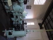
No.6 Pumping Station (fmr), Ghooli is one of eight original pumping stations located along the Goldfields Water Supply Scheme that pumped water from Mundaring Weir to Kalgoorlie. Constructed between 1901 and 1902, it is of brickwork masonry construction with a pitched roof of corrugated iron sheeting. There is an adjacent coal bin shelter structure with a railway formation to the south and a dominant tall steel chimney to the west. The building is a simple functional structure designed by the Public Works Department with the involvement of architect George Temple Poole.
Mundaring Weir represents the start of the Mundaring to Kalgoorlie Pipeline. Water was pumped via a 560 kilometre-long pipeline from Mundaring in the Darling Range to Mount Charlotte Reservoir in Kalgoorlie via a series of pumping stations and reservoirs. The original eight steam pump stations used the water in the storage tanks to generate steam to power the engines to further pump water along the pipeline. The pumping of water along the pipeline began at the No. 1 station in Mundaring on 31 March 1902, with water reaching Northam on 18 April. It progressively moved through Cunderdin, Merredin, Yerbillon and Southern Cross, reaching No. 6 Steam Pumping Station (fmr), Ghooli in November 1902. Once operational, No. 6 Steam Pumping Station (fmr), Ghooli required constant upgrades and maintenance. General inspections were carried out each year and major inspections every seven or ten years. Inspections required the large scale removal of elements, including—in the case of the boilers—portions of internal brick walls. Removed items were then reused or replaced, with the defunct materials dumped on the rubbish tip across the Great Eastern Highway. The original bricklined steel chimney was replaced by the existing structure between 1913 and 1914 due to internal corrosion. During World War II, the importance of maintaining the supply of water to the Eastern Goldfields and the Wheatbelt was such that the pump stations were guarded from potential attack. In Ghooli, this role was undertaken by locals from the nearby town of Southern Cross. In April 1953, electricity was installed at the No. 6 Steam Pumping Station (fmr), Ghooli. Following the conversion from steam power to electricity the station continued operation until 1969 when it was replaced by the pump station constructed to the north nearer to the pipeline conduit. When No. 6 Steam Pumping Station (fmr), Ghooli closed, all machinery and equipment was left in situ. However due to theft, vandalism and repeated flooding, by 1999 the original boilers, economizers, and air pumps were no longer completely intact and most exhibited signs of damage and corrosion.
No.6 Pumping Station (fmr), Ghooli is in very poor condition. Damage is largely due to water ingress through failure of the roof sheeting and the inherent design of the building where the sub-floor of the engine (pump) room is lower than the external ground level. The roof covering to both the pump station building and coal bin structure is showing signs of extreme wear and tear due to severe corrosion, and missing and lifting sheets. Although some of the original machinery and equipment still remain, many parts are missing, and the fabric has deteriorated. Externally, the brickwork is failing in places with fretting mortar joints and erosion of the brick face, particularly near to ground level. Exposed timber components of bargeboards, fascia and gutter brackets all show signs of decay, damage and are missing in parts. Internal brickwork is suffering from severe erosion and salt attack.
| Library Id | Title | Medium | Year Of Publication |
|---|---|---|---|
| 7356 | Conservation plan for Goldfields Water Supply Scheme. Volume II, place I : No. 6 Pumping Station, Ghooli. | Heritage Study {Cons'n Plan} | 1999 |
Individual Building or Group
| Epoch | General | Specific |
|---|---|---|
| Original Use | GOVERNMENTAL | Pumping Station |
| Present Use | VACANT\UNUSED | Vacant\Unused |
| Style |
|---|
| Federation Warehouse |
| Type | General | Specific |
|---|---|---|
| Roof | METAL | Corrugated Iron |
| Wall | BRICK | Common Brick |
| General | Specific |
|---|---|
| SOCIAL & CIVIC ACTIVITIES | Community services & utilities |
This information is provided voluntarily as a public service. The information provided is made available in good faith and is derived from sources believed to be reliable and accurate. However, the information is provided solely on the basis that readers will be responsible for making their own assessment of the matters discussed herein and are advised to verify all relevant representations, statements and information.
Constructed from 1902
This place has historic, scientific and social significance. The Goldfields Water Scheme, the brain child of CY O'Connor, was a major engineering feat and has been a major contributor to the development of WA. It was, and still is, of prime importance to the State. The Ghooli Pumping Station is in good condition and offeres an opportunity to preserve a memorial to the scheme and the way of life outside the metropolitan area. It is easily accessible from the main highway, so it has tourist potential. The pump station has been entered on the Register of the National Estate, and is also listed on the WA State Register of Heritage Places.
No 6 Pumping Station at Ghooli was one of a chain of pumping stations which made possible the ambitious scheme of transporting water from Mundaring Weir, through a 350 mile pipeline to the Goldfields after 1902. The building is a substantial brick structure still in its original condition: It housed huge boilers which produced steam pressure for the pump engines. It was in use until 1969 when it was superseded by an electric pump. It is a unique example of a goldfields water supply scheme steam pumping station and is easily accessible from the main highway.
Themes: Community Efforts, Services & Utilities
Much of the original fabric is intact.
Good
| Owner | Category |
|---|---|
| DOLA Water Corporation | State Gov't |
This information is provided voluntarily as a public service. The information provided is made available in good faith and is derived from sources believed to be reliable and accurate. However, the information is provided solely on the basis that readers will be responsible for making their own assessment of the matters discussed herein and are advised to verify all relevant representations, statements and information.
Great Eastern Hwy Koorarawalyee
At Shire Boundary Yilgarn/Coolgardie, at Yilgarn barrier fence
Koorarawalyee Sumit Tank
Yilgarn
Wheatbelt
| Type | Status | Date | Documents |
|---|---|---|---|
| (no listings) |
| Type | Status | Date | Documents |
|---|---|---|---|
| RHP - Assessed - Deferred | Current | 25 Mar 2005 |
| Type | Status | Date | Grading/Management | |
|---|---|---|---|---|
| Category | ||||
| (no listings) | ||||
16610 Goldfields Water Supply Scheme
• The place has associations with the establishment of the railway network to the Eastern Goldfields during the gold boom of the 1890s.
• The place forms part of system of reservoirs and dams established to provide water for the steam engines that once operated on the railway; a function which is no longer practised.
• As with the other dams along the line, the place is now used as a recreation spot by visitors.
• The place is a good example of an above ground water storage tank.
The place is a round stone water storage tank, which appears to have at some stage been reinforced with concrete. On the south side of the tank is a stone overflow shute, and on the north side is a pipeline. The site has one above ground concrete tank.
A project which is part of a series of initiatives being undertaken by the Water Corporation's Agricultural Region to improve quality and security of water supplies, includes the commissioning of Walgoolan Pump Station and the Koorarawalyee Tank (both east of Merredin) in March and the Goodlands Rural Water Supply Improvement project, also due for completion early next year.
High
Good
| Library Id | Title | Medium | Year Of Publication |
|---|---|---|---|
| 7210 | Images CD No. 35 : assessment images : Bronte Summit Tank, Koorarawalyee. | C D Rom | 2004 |
Historic site
| Epoch | General | Specific |
|---|---|---|
| Present Use | GOVERNMENTAL | Reservoir or Dam |
| Original Use | GOVERNMENTAL | Reservoir or Dam |
| Type | General | Specific |
|---|---|---|
| Wall | CONCRETE | Reinforced Concrete |
| General | Specific |
|---|---|
| DEMOGRAPHIC SETTLEMENT & MOBILITY | Resource exploitation & depletion |
This information is provided voluntarily as a public service. The information provided is made available in good faith and is derived from sources believed to be reliable and accurate. However, the information is provided solely on the basis that readers will be responsible for making their own assessment of the matters discussed herein and are advised to verify all relevant representations, statements and information.
Mundaring
P25251 Goldfields Water Supply Scheme is part of this place and is on the National Heritage List. Starts in Mundaring, at Mundaring Weir and travels through the Shires of Mundaring, Northam, Cunderdin, Tammin, Kellerberrin, Merredin, Westonia, Yilgarn, Coolgardie and Kalgoorlie-Boulder.
Golden Pipeline
Mundaring
Metropolitan
Constructed from 1898
| Type | Status | Date | Documents |
|---|---|---|---|
| State Register | Registered | 08 Dec 2022 | HCWebsite.Listing+ListingDocument, HCWebsite.Listing+ListingDocument |
| Type | Status | Date | Documents |
|---|---|---|---|
| (no listings) |
| Type | Status | Date | Grading/Management | |
|---|---|---|---|---|
| Category | ||||
| (no listings) | ||||
25251 Goldfields Water Supply Scheme (NHL)
• The place is an excellent example of an initiative by the Western Australian Government to provide water to the Goldfields at the turn of the century.
• The place is rare as one of the largest pipelines in Western Australia, possibly the largest that supplies water.
• The place has aesthetic value as a landmark feature extending from Mundaring to Kalgoorlie.
• The place is rare and has scientific value as an innovative engineering design and construction method of a pipeline from the early 20th Century.
• The place is rare as a long-distance water pipeline in Australia built in the early 1900’s.
The Goldfields Water Supply Scheme, demonstrates exceptional technical achievement as one of the longest overland pipeline schemes attempted in the nineteenth century, both in Australia and the world, and was recognised as an outstanding engineering achievement; The has exceptional value in demonstrating the historical importance of the provision of water to settlements along the route from Mundaring to the Eastern Goldfields, The construction and operation of the Pipeline had considerable importance in contributing to the sense of place for the people of Western Australia, and visitors to the State, as a highly valued tourist destination, the educational, cultural and aesthetic aspects of which are appreciated by history and engineering enthusiasts and teachers to this day; Individual elements of the place, including the existing interpretation associated with the Golden Pipeline Heritage Trail, museums, archaeological sites and remaining buildings and infrastructure, collectively have exceptional potential to communicate the history of the Goldfields Water Supply Scheme and its importance to Western Australia; The place is associated with a number of notable figures in Western Australian history, including the Scheme's designer CY O'Connor, State and Federal politician Lord John Forrest, the Director of the Public Works Department HW Venn and former Superintendent of Public Works, architect George Temple Poole, who each contributed to the successful completion of the Goldfields Water Supply Scheme; and The place is an exceptional example of applied science, technical excellence and innovative design, reflecting the ongoing ingenuity and innovation demonstrated by the talented and committed engineers employed by the Goldfields Water Supply Branch, Public Works Department and other iterations of the Water Corporation in the provision of water in the State. The longevity of the scheme is associated with innovators Mephan Ferguson, James Couston, engineers Norman Fernie and Reg Keating, and James Mathers.
The Goldfields Water Supply Scheme extends in a discontiguous precinct across the 560km linear water pipeline, commencing at Mundaring Weir (1902, 1951) in the Helena Valley and terminating at Mount Charlotte Reservoir (1902) in Kalgoorlie-Boulder. Comprising six extant original Steam Pump Stations (1902) at Mundaring, Cunderdin, Merredin, Yerbillon, Ghooli and Dedari; the sites of two demolished Steam Pump Stations (1902) at O’Connor and Gilgai; Reservoirs and Tanks at O’Connor, Sawyers Valley, Bakers Hill, West Northam, Cunderdin, Merredin, Yerbillon, Ghooli, Bronti, Gilgai, Koorawawalyee, Dedari, Toorak, and Bullabulling; second generation Electric Pump Station at Merredin , and other community sites, ancillary structures; equipment and machinery, archaeological sites; and discontiguous portions of the main pipeline conduit associated with the construction and operation of the Scheme from 1902 to the present.
Phase I - Construction of the Goldfields Water Supply Scheme (1898 - 1903) Phase II – Problem Solving and Agricultural Expansion (1904 - 1940) Phase III – Comprehensive Water Supply Scheme, Upgrades & Refurbishments (1946 - 2013) Phase IV - Heritage Recognition and The Golden Pipeline (1992 - 2011)
High
Good
| Name | Type | Year From | Year To |
|---|---|---|---|
| Charles Yelverton O'Connor | Architect | 1898 | 1902 |
| Library Id | Title | Medium | Year Of Publication |
|---|---|---|---|
| 6452 | Mundaring Weir Precinct masterplan : final master plan report. | Heritage Study {Other} | 2002 |
| 7358 | Conservation plan for Goldfields Water Supply Scheme. Volume II, place M : No. 8 Pumping Station, Dedari. | Heritage Study {Cons'n Plan} | 1999 |
| 11426 | Goldfields Water Supply Volume III | Heritage Study {Cons'n Plan} | 1999 |
| 4897 | Conservation plan for Karalee Rock Water Catchment (Goldfields Water Supply Scheme - place J). | Heritage Study {Cons'n Plan} | 2000 |
| 7359 | Conservation plan for Goldfields Water Supply Scheme. Volume II, place N : Bullabulling reservoir. | Heritage Study {Cons'n Plan} | 1999 |
| 9248 | Constructing Australia: Triumphs and tragedies in building a nation. | C D Rom | 2007 |
| 6390 | Pipe-dream to pipeline : the eventful life of Nathaniel W. Harper. | Book | 2001 |
| 3680 | Conservation plan for No. 3 Pumping Station, Cunderdin. | Heritage Study {Cons'n Plan} | 1998 |
| 1774 | An exploratory bibliography of the Goldfields Water Supply of Western Australia (draft). | Report | 1982 |
| 4504 | Conservation plan for Mount Charlotte Reservoir (Goldfields water supply scheme - place O). | Heritage Study {Cons'n Plan} | 2000 |
| 11762 | Goldfields Water Supply Scheme, Main conduit, Western Australia | Heritage Study {Cons'n Plan} | 2016 |
| 6788 | Conservation plan for Koorarawalyee water catchment and railway station (Draft) (Goldfields Water Supply Scheme - place U). | Heritage Study {Cons'n Plan} | 2001 |
| 9806 | Mundaring Weir water Supply interpretation precinct design. | Book | 2010 |
| 7350 | Conservation plan for West Northam regulating tanks : (Goldfields Water Supply Scheme - place T) (draft). | Heritage Study {Cons'n Plan} | 2001 |
| 7356 | Conservation plan for Goldfields Water Supply Scheme. Volume II, place I : No. 6 Pumping Station, Ghooli. | Heritage Study {Cons'n Plan} | 1999 |
| 7547 | Celebrating 100 years of the Goldfields Water Supply Scheme. | Brochure | 2003 |
| 7354 | Conservation plan for Goldfields Water Supply Scheme. Volume II, place G : No. 4 Pumping Station, Merredin. | Heritage Study {Cons'n Plan} | 1999 |
| 7351 | Conservation plan for Toorak Hill reservoir : (Goldfields Water Supply Scheme - place V) (draft). | Heritage Study {Cons'n Plan} | 2001 |
| 7352 | Conservation plan for Goldfields Water Supply Scheme. Volume II, place A : No. 1 Pumping Station Mundaring. | Heritage Study {Cons'n Plan} | 1999 |
| 7348 | Conservation plan for Sawyers Valley summit tanks : (Goldfields Water Supply Scheme - place R) (draft). | Heritage Study {Cons'n Plan} | 2001 |
| 6675 | Mundaring Weir : conservation plan (draft). | Heritage Study {Cons'n Plan} | 2000 |
| 1608 | Conservation and interpretation plan for No.1 Pumping Station Mundaring. | Heritage Study {Cons'n Plan} | 1996 |
| 5988 | Centenary of the Goldfields Water Supply Scheme 1903-2003. | Brochure | 2003 |
| 7444 | The agricultural areas, Great Southern towns and Goldfields Water Supply Scheme : souvenir to commemorate the completion of the project. | Book | 1961 |
| 10170 | The origins of the Eastern Goldfields water scheme in Western Australia: an exercise in the interpretation of historical evidence. | Book | 1954 |
| 4644 | Conservation plan for Goldfields Water Supply Scheme : volume 1. | Heritage Study {Cons'n Plan} | 1999 |
| 7357 | Conservation plan for Goldfields Water Supply Scheme. Volume II, place K : No. 7 Pumping Station, Gilgai. | Heritage Study {Cons'n Plan} | 1999 |
| 8902 | River of steel. A history of the Western Australian Goldfields and Agricultural Water Supply 1903 - 2003. | Book | 2007 |
| 7355 | Conservation plan for Goldfields Water Supply Scheme. Volume II, place H : No. 5 Pumping Station, Yerbillon. | Heritage Study {Cons'n Plan} | 1999 |
| 7353 | Conservation plan for Goldfields Water Supply Scheme. Volume II, place B : No. 2 Pumping Station, O'Connor. | Heritage Study {Cons'n Plan} | 1999 |
| 7349 | Conservation plan for Bakers Hill regulating tank : (Goldfields Water Supply Scheme - place S) (draft). | Heritage Study {Cons'n Plan} | 2001 |
| 6794 | Conservation plan for Bullabulling township and railway catchment. (draft) : a supplement to the Bullabulling Reservoir conservation plan (Goldfields Water Supply Scheme - place N). | Heritage Study {Cons'n Plan} | 2001 |
| 9899 | Mundaring Weir water supply improvement project: heritage management strategy. | Heritage Study {Other} | 2011 |
| 6326 | The golden pipeline heritage trail guide : a time capsule of water, gold and Western Australia. | Book | 2002 |
| 4693 | Goldfields Water Supply heritage project. | Book | 1999 |
| 5544 | Golden Pipeline interpretation plan. | Heritage Study {Other} | 2001 |
Other Built Type
| Epoch | General | Specific |
|---|---|---|
| Original Use | GOVERNMENTAL | Power Station |
| Present Use | GOVERNMENTAL | Pumping Station |
| Present Use | EDUCATIONAL | Museum |
| Style |
|---|
| Vernacular |
| Type | General | Specific |
|---|---|---|
| Wall | BRICK | Common Brick |
| Wall | METAL | Steel |
| Roof | METAL | Corrugated Iron |
| General | Specific |
|---|---|
| SOCIAL & CIVIC ACTIVITIES | Community services & utilities |
| DEMOGRAPHIC SETTLEMENT & MOBILITY | Technology & technological change |
| DEMOGRAPHIC SETTLEMENT & MOBILITY | Resource exploitation & depletion |
| DEMOGRAPHIC SETTLEMENT & MOBILITY | Exploration & surveying |
This information is provided voluntarily as a public service. The information provided is made available in good faith and is derived from sources believed to be reliable and accurate. However, the information is provided solely on the basis that readers will be responsible for making their own assessment of the matters discussed herein and are advised to verify all relevant representations, statements and information.
about 50 km E of Southern Cross
Yilgarn
Wheatbelt
Constructed from 1897
| Type | Status | Date | Documents |
|---|---|---|---|
| State Register | Registered | 14 Dec 2001 | HCWebsite.Listing+ListingDocument, HCWebsite.Listing+ListingDocument |
| Type | Status | Date | Documents |
|---|---|---|---|
| (no listings) |
| Type | Status | Date | Grading/Management | |
|---|---|---|---|---|
| Category | ||||
| Statewide Lge Timber Str Survey | Completed | 11 Dec 1998 | ||
| Classified by the National Trust | Classified | 12 Mar 2001 | ||
| Municipal Inventory | Adopted | 16 May 1997 | Category D | |
24806 Hunt's Wells Group
Generally good except for except aqueduct from No. 1 Rock need repair
| Name | Type | Year From | Year To |
|---|---|---|---|
| W H Shields | Architect | - | - |
| Library Id | Title | Medium | Year Of Publication |
|---|---|---|---|
| 6042 | Karalee Rock Dam and Aqueduct east of Southern Cross: conservation works. + Karalee Dam work procedure. | Conservation works report | 2003 |
| 4897 | Conservation plan for Karalee Rock Water Catchment (Goldfields Water Supply Scheme - place J). | Heritage Study {Cons'n Plan} | 2000 |
Other Built Type
| Epoch | General | Specific |
|---|---|---|
| Original Use | Transport\Communications | Water: Other |
| Original Use | GOVERNMENTAL | Reservoir or Dam |
| Present Use | SOCIAL\RECREATIONAL | Other |
| Type | General | Specific |
|---|---|---|
| Other | TIMBER | Other Timber |
| Wall | STONE | Granite |
| Other | METAL | Cast Iron |
| Wall | STONE | Local Stone |
| General | Specific |
|---|---|
| DEMOGRAPHIC SETTLEMENT & MOBILITY | Aboriginal Occupation |
| TRANSPORT & COMMUNICATIONS | Technology & technological change |
| TRANSPORT & COMMUNICATIONS | Road transport |
| TRANSPORT & COMMUNICATIONS | Rail & light rail transport |
This information is provided voluntarily as a public service. The information provided is made available in good faith and is derived from sources believed to be reliable and accurate. However, the information is provided solely on the basis that readers will be responsible for making their own assessment of the matters discussed herein and are advised to verify all relevant representations, statements and information.
16610 Goldfields Water Supply Scheme
A regular water supply has always been a critical issue for survival in the Yilgarn region owing to the arid conditions and the absence of freshwater rivers or artesian springs. The large number and variety of man made structures such as dams and wells, reflects the settlement patterns chosen over time. The locations (sites) of the structures were carefully chosen to maximise the natural water catchment areas. Even these numerous watering holes were not sufficient, and water supply had to be supplemented, using saline bore water, processed in condensers at various locations in the region.
Karalee is an attractive example of a Railway Dam built to supply steam engines with the water they needed. Today it is a popular recreation spot for local people and visitors.
Karalee Reservoir, Rock Catchment & Aqueduct is a former railway water source comprising natural granite rock formations and stone retaining walls, trenches and stone sluices, a stone, timber and riveted iron aqueduct (in ruins) and an earth and stone water reservoir. Hunt’s Well and Dam form part of a chain of water sources established by C.C. Hunt in the 1860s and have rarity value as part of a series of endangered and extraordinary structures. While similar in respects to many other railway catchment systems, Karalee Reservoir, Rock Catchment & Aqueduct is unique in WA for the use of a steel aqueduct structure. Class C reserve No. 3531.
| Name | Type | Year From | Year To |
|---|---|---|---|
| W. H. Shields | Architect | - | - |
| Owner | Category |
|---|---|
| National Trust of Australia (WA) | Inc. Non-profit body |
This information is provided voluntarily as a public service. The information provided is made available in good faith and is derived from sources believed to be reliable and accurate. However, the information is provided solely on the basis that readers will be responsible for making their own assessment of the matters discussed herein and are advised to verify all relevant representations, statements and information.

50 Altair St Southern Cross
Domus Di
St Joseph's Catholic Church
Yilgarn
Wheatbelt
Constructed from 1936
| Type | Status | Date | Documents |
|---|---|---|---|
| Heritage List | Adopted | 07 Aug 1998 | |
| State Register | Registered | 17 Aug 2012 | HCWebsite.Listing+ListingDocument, HCWebsite.Listing+ListingDocument |
| Type | Status | Date | Documents |
|---|---|---|---|
| (no listings) |
| Type | Status | Date | Grading/Management | |
|---|---|---|---|---|
| Category | ||||
| Art Deco Significant Bldg Survey | Completed | 30 Jun 1994 | ||
| Catholic Church Inventory | Adopted | 01 Jul 1998 | ||
| Municipal Inventory | Adopted | 16 May 1997 | Category B | |
Good
| Name | Type | Year From | Year To |
|---|---|---|---|
| Cavanagh (James), Cavanagh (Michael) & Tracey | Architect | - | - |
| Library Id | Title | Medium | Year Of Publication |
|---|---|---|---|
| 9561 | Our Lady of Montserrat Church, Southern Cross: conservation management plan. DRAFT for comment. | Heritage Study {Cons'n Plan} | 2009 |
Individual Building or Group
| Epoch | General | Specific |
|---|---|---|
| Present Use | RELIGIOUS | Church, Cathedral or Chapel |
| Original Use | RELIGIOUS | Church, Cathedral or Chapel |
| Style |
|---|
| Inter-War Romanesque |
| Inter-War Art Deco |
| Type | General | Specific |
|---|---|---|
| Wall | BRICK | Common Brick |
| Roof | METAL | Corrugated Iron |
| General | Specific |
|---|---|
| DEMOGRAPHIC SETTLEMENT & MOBILITY | Depression & boom |
| SOCIAL & CIVIC ACTIVITIES | Religion |
| DEMOGRAPHIC SETTLEMENT & MOBILITY | Settlements |
This information is provided voluntarily as a public service. The information provided is made available in good faith and is derived from sources believed to be reliable and accurate. However, the information is provided solely on the basis that readers will be responsible for making their own assessment of the matters discussed herein and are advised to verify all relevant representations, statements and information.
Constructed from 1936
This church, built in 1936, was opened by Lord Abbot Anselm Catalan on 26th April 1936. It was the culmination of the dream and foresight of the Parish Priest, Rev Fr Plaaas, who arrived in 1923. The architects were Cavanagh, Cavanagh & Tracey of Perth who had original drawings by Fr (later Abbot) Gusi OSB. Up to this time there had been no Catholic Church in Southern Cross, with Mass being celebrated in an un-named hall, later to be called St Joseph's Hall and, still later, the Sacred Heart Hall. Of the £845 raised in Spain, Fr Planas' family donated £570. The final cost of the church was £2000. It was named Our Lady of Montserrat St Mary's Church, after the Patron of Barcelona, in gratitude for the money raised there. The face bricks inside the building came from the Maori Lass Mine near Southern Cross. The first Parish Priest to come to Southern Cross in 1896 was Fr William Prendergast and the first Baptism was solemnised on 14th June the same year. Succeeding priests were Frs Wilfred Hampson, Gerald Griffin and Richard O'Neill.
This church is on relatively high ground and is a prominent building in the town. It is soundly built and is a striking structure. The fence at the front has been altered and is now a low brick fence with no gates. The cross on top of the bell tower can be lit up and seen from many miles around. The red brick church is characterised by a number of fundamental inter-war period architectural features. It is built on an imposing scale with a symmetrical facade and a minimal use of motifs and detail.
All intact
Very Good
| Owner | Category |
|---|---|
| Catholic Church | Church Property |
This information is provided voluntarily as a public service. The information provided is made available in good faith and is derived from sources believed to be reliable and accurate. However, the information is provided solely on the basis that readers will be responsible for making their own assessment of the matters discussed herein and are advised to verify all relevant representations, statements and information.

Antares St Southern Cross
School Photographic Laboratory
Yilgarn
Wheatbelt
| Type | Status | Date | Documents |
|---|---|---|---|
| Heritage List | Adopted | 07 Aug 1998 |
| Type | Status | Date | Documents |
|---|---|---|---|
| (no listings) |
| Type | Status | Date | Grading/Management | |
|---|---|---|---|---|
| Category | ||||
| Municipal Inventory | Adopted | 16 May 1997 | Category B | |
10022 Old Primary School, Southern Cross
Individual Building or Group
| Epoch | General | Specific |
|---|---|---|
| Present Use | EDUCATIONAL | Other |
| Original Use | GOVERNMENTAL | Police Station or Quarters |
| Type | General | Specific |
|---|---|---|
| Roof | METAL | Corrugated Iron |
| Wall | METAL | Corrugated Iron |
| General | Specific |
|---|---|
| SOCIAL & CIVIC ACTIVITIES | Law & order |
This information is provided voluntarily as a public service. The information provided is made available in good faith and is derived from sources believed to be reliable and accurate. However, the information is provided solely on the basis that readers will be responsible for making their own assessment of the matters discussed herein and are advised to verify all relevant representations, statements and information.
Constructed from 1907
The lockup was once part of the Police Station. It became obsolete when the new Police Station was built in the 1970s. Today it is used as a photographic development laboratory.
The wall and roof are constructed from corrugated iron. The roof is hipped with an interesting gabled ventilation section at the apex. The bars on the windows, the small windows and the high positioning of the windows are a reminder that the building was once a lockup.
Themes: Community Efforts, Law and Order
From external view the original fabric appears to be intact.
Very Good
| Owner | Category |
|---|---|
| Southern Cross District High School | Other Private |
This information is provided voluntarily as a public service. The information provided is made available in good faith and is derived from sources believed to be reliable and accurate. However, the information is provided solely on the basis that readers will be responsible for making their own assessment of the matters discussed herein and are advised to verify all relevant representations, statements and information.

24 Antares St Southern Cross
Yilgarn
Wheatbelt
Constructed from 1892
| Type | Status | Date | Documents |
|---|---|---|---|
| Heritage List | Adopted | 07 Aug 1998 | |
| State Register | Registered | 09 Feb 1996 | HCWebsite.Listing+ListingDocument, HCWebsite.Listing+ListingDocument |
| Type | Status | Date | Documents |
|---|---|---|---|
| (no listings) |
| Type | Status | Date | Grading/Management | |
|---|---|---|---|---|
| Category | ||||
| Municipal Inventory | Adopted | 16 May 1997 | Category A | |
| Classified by the National Trust | Classified | 08 Mar 1994 | ||
| Statewide Post Office Survey | Completed | 01 Mar 1992 | ||
| Name | Type | Year From | Year To |
|---|---|---|---|
| George Temple-Poole | Architect | - | - |
Individual Building or Group
| Epoch | General | Specific |
|---|---|---|
| Original Use | Transport\Communications | Comms: Post or Telegraph Office |
| Present Use | Transport\Communications | Comms: Post or Telegraph Office |
| Style |
|---|
| Victorian Georgian |
| Type | General | Specific |
|---|---|---|
| Roof | METAL | Corrugated Iron |
| Wall | BRICK | Face Brick |
| Wall | STONE | Local Stone |
| Wall | BRICK | Handmade Brick |
| Wall | PLASTER | Lathe and Plaster |
| General | Specific |
|---|---|
| TRANSPORT & COMMUNICATIONS | Telecommunications |
| TRANSPORT & COMMUNICATIONS | Mail services |
This information is provided voluntarily as a public service. The information provided is made available in good faith and is derived from sources believed to be reliable and accurate. However, the information is provided solely on the basis that readers will be responsible for making their own assessment of the matters discussed herein and are advised to verify all relevant representations, statements and information.
Constructed from 1892
The discovery of gold in 1888 and the subsequent influx of prospectors and miners in the area resulted in the need for postal and communication links to and from the district. A post office was opened at Golden Valley in July 1888, and with the increase in the volume of mail, a weekly horse and cart contract service was established. When gold was found in greater quantity at Southern Cross, many people moved there and the post office at Golden Vally was moved to Southern Cross. The telegraph lines arrived in Southern Cross before the building was completed, so Mr Harvey, the officer in charge, set up his apparatus in the middle of the street, protected by a large umbrella. The Southern Cross Post Office became a post and telegraph office in February 1892. With Federation in 1901, the Post Office and Residence remained under Commonwealth control, while the remaining Offices came under State control. The significance of the Southern Cross Post Office has been recognised by the Heritage Council of WA, and the building was entered on the Register of Heritage Places on a Permanent basis in February 1996.
The Commonwealth began construction of this Post Office, Residence, Court House and Mining Registrar's Offices, all under one roof, in 1891-2. The Post Office was constructed one year prior to the adjoining Warden's Court which shares a common wall with the Post Offfice Residence. The Post Office is a single storey building, designed by George Temple Poole, the eminent Government architect, and built by J S Bruce. The outer walls of the Post Office are bonded brick with rendered plinths to window sill height and rendered architraves. The bricks were made of sun dried clay with mud bonding. The external masonry has been painted. The corrugated iron roof extends to form a verandah supported by timber posts to the south and east elevations. The residence is located to the northern end of the building and consisted of 3 bedrooms, living room, kitchen, bathroom and laundry. Alterations and additions were carried out in 1929. Since then the building has been painted and the original picket fence has been removed.
Themes: Transport and Communications Sub Themes: Post Office/ Residence
Most of the original fabric is intact
Good
| Name | Type | Year From | Year To |
|---|---|---|---|
| George Temple Poole | Architect | - | - |
| Owner | Category |
|---|---|
| R & P Blair | Other Private |
This information is provided voluntarily as a public service. The information provided is made available in good faith and is derived from sources believed to be reliable and accurate. However, the information is provided solely on the basis that readers will be responsible for making their own assessment of the matters discussed herein and are advised to verify all relevant representations, statements and information.

26 Antares St Southern Cross
Yilgarn History Museum
Yilgarn
Wheatbelt
Constructed from 1892 to 1950
| Type | Status | Date | Documents |
|---|---|---|---|
| Heritage List | Adopted | 07 Aug 1998 | |
| State Register | Registered | 24 Nov 2000 | HCWebsite.Listing+ListingDocument, HCWebsite.Listing+ListingDocument |
| Type | Status | Date | Documents |
|---|---|---|---|
| (no listings) |
| Type | Status | Date | Grading/Management | |
|---|---|---|---|---|
| Category | ||||
| Municipal Inventory | Adopted | 16 May 1997 | Category A | |
| Register of the National Estate | Indicative Place | |||
| Classified by the National Trust | Recorded | 07 Feb 1972 | ||
| Name | Type | Year From | Year To |
|---|---|---|---|
| Hillson Beasley | Architect | - | - |
| George Temple-Poole | Architect | - | - |
| Library Id | Title | Medium | Year Of Publication |
|---|---|---|---|
| 4104 | Conservation Plan Yilgarn History Museum: Courthouse and Mining Registrar's Office Building Southern Cross | Heritage Study {Cons'n Plan} | 1999 |
Individual Building or Group
| Epoch | General | Specific |
|---|---|---|
| Original Use | RESIDENTIAL | Single storey residence |
| Original Use | GOVERNMENTAL | Courthouse |
| Present Use | EDUCATIONAL | Museum |
| Style |
|---|
| Victorian Regency |
| Type | General | Specific |
|---|---|---|
| Roof | METAL | Corrugated Iron |
| Roof | TIMBER | Other Timber |
| Wall | BRICK | Common Brick |
| General | Specific |
|---|---|
| DEMOGRAPHIC SETTLEMENT & MOBILITY | Government policy |
| SOCIAL & CIVIC ACTIVITIES | Law & order |
| SOCIAL & CIVIC ACTIVITIES | Cultural activities |
| DEMOGRAPHIC SETTLEMENT & MOBILITY | Resource exploitation & depletion |
| OCCUPATIONS | Mining {incl. mineral processing} |
| SOCIAL & CIVIC ACTIVITIES | Education & science |
This information is provided voluntarily as a public service. The information provided is made available in good faith and is derived from sources believed to be reliable and accurate. However, the information is provided solely on the basis that readers will be responsible for making their own assessment of the matters discussed herein and are advised to verify all relevant representations, statements and information.
Constructed from 1892
The discovery of gold in 1888 led to the needs of the prospectors and mining fraternity having to be addressed. This building is significant for that reason. It is the olderst surviving Government building in Southern Cross, typical of stone office buildings erected in the 1890s. It is also significant as one of the buildings designed by the eminent government architect, George Temple-Poole. Over the years it fell into disrepair, with cracks developing in the walls, and was condemned. A public petition in 1976, against demolition, resulted in the building being saved and vested in the Yilgarn Shire in 1976 for use as a museum. The Court House was relocated in Canopus Street and the Museum officially opened on 3 August 1979. A time capsule, to be opened in 2013 AD, has been placed in the forecourt.
The building stands adjacent to the District High School. Building started in 1892 on the Commonwealth constructed Post Office, Residence, Court House, Mining Registrar's Offices and residence, all under one roof. Locally made sun-baked bricks were used to build the walls. Local bush timber, some of which may still be seen under the P.O. verandah, was used as rafters. With Federation in 1901 the Post Office and Residence remained under Federal Government control while the others became State controlled. The Registrar's house was demolished in 1952.
Theme: Demographic Settlement
Majority of original fabric is still intact.
Good
| Name | Type | Year From | Year To |
|---|---|---|---|
| George Temple Poole | Architect | - | - |
| Hillson Beasley | Architect | - | - |
| Owner | Category |
|---|---|
| Southern Cross Historical Society | Other Private |
This information is provided voluntarily as a public service. The information provided is made available in good faith and is derived from sources believed to be reliable and accurate. However, the information is provided solely on the basis that readers will be responsible for making their own assessment of the matters discussed herein and are advised to verify all relevant representations, statements and information.

28 Antares St Southern Cross
Forrester Resource Centre
Old State School
Yilgarn
Wheatbelt
Constructed from 1895, Constructed from 1896
| Type | Status | Date | Documents |
|---|---|---|---|
| Heritage List | Adopted | 07 Aug 1998 | |
| State Register | Registered | 15 Jan 2013 | HCWebsite.Listing+ListingDocument, HCWebsite.Listing+ListingDocument |
| Type | Status | Date | Documents |
|---|---|---|---|
| (no listings) |
| Type | Status | Date | Grading/Management | |
|---|---|---|---|---|
| Category | ||||
| Municipal Inventory | Adopted | 16 May 1997 | Category A | |
| Register of the National Estate | Indicative Place | |||
Old Primary School (fmr) is in fair to good condition having been in continued educational use since construction. Regular maintenance has been applied to those areas in constant use whereas some environmental effects are evident on the exterior, particularly the rising damp damage and subsequent repairs to the stone walls.
| Name | Type | Year From | Year To |
|---|---|---|---|
| George Temple-Poole | Architect | 1895 | 1896 |
Individual Building or Group
| Epoch | General | Specific |
|---|---|---|
| Original Use | EDUCATIONAL | Primary School |
| Present Use | EDUCATIONAL | Library |
| Other Use | EDUCATIONAL | Other |
| Style |
|---|
| Federation Arts and Crafts |
| Type | General | Specific |
|---|---|---|
| Roof | METAL | Corrugated Iron |
| Wall | STONE | Other Stone |
| General | Specific |
|---|---|
| SOCIAL & CIVIC ACTIVITIES | Education & science |
| DEMOGRAPHIC SETTLEMENT & MOBILITY | Resource exploitation & depletion |
| OCCUPATIONS | Mining {incl. mineral processing} |
| DEMOGRAPHIC SETTLEMENT & MOBILITY | Settlements |
| SOCIAL & CIVIC ACTIVITIES | Community services & utilities |
This information is provided voluntarily as a public service. The information provided is made available in good faith and is derived from sources believed to be reliable and accurate. However, the information is provided solely on the basis that readers will be responsible for making their own assessment of the matters discussed herein and are advised to verify all relevant representations, statements and information.
Constructed from 1896, Constructed from 1895
This building has considerable aesthetic, historic and social value. Built as a school in 1895, the building has contributed to the education needs of the town since that time. The 1890s saw a population boom in the district as a result of the goldfields, and by 1901, children under 14 made up one third of the population. The school has been added to extensively over time, and the original school is now known as the Forrester Resource Centre, housing the libraiy and other important resources. The Southern Cross District High School, of which the Resource Centre is now part, holds a wealth of historic value apart from the Resource Centre: • While building the original school the builders found a reef of gold running north of the corner of the yard. • A house built in 1895, originally the headmaster's residence, is still in the school grounds. It still has the basic rafters and original wood under the modernisation. • The old jail/Police Lockup is also in the grounds and is used as a photographic centre. (Refer PI No 11) • The original well, now unused, is still underground.
Built in 1895, this imposing stone building has a prominent position in the main street of Southern Cross. The original school consisted of two large rooms, 30'x22' and 20'x20' The walls are local stone, with red brick quoining on the corners and around the windows. The steeply pitched roof is made of colorbond corrugated iron, and the prominent gable facing the street has a half-timbered effect. A circular accent is another feature on the front wall. Lofty ceilings allow for good ventilation. Along the north side of the building is a verandah supported by wooden posts. Another wing of the building runs in a north south direction. It also has a verandah on the east side supported by posts with additional wooden trim. Fireplaces allowed for heating in the original school, and an underground water tanks used to hold 10,000 gal for use by the school.
Themes: Community Efforts & Education
Mostly intact
Very Good
| Owner | Category |
|---|---|
| Southern Cross District High School | Other Private |
This information is provided voluntarily as a public service. The information provided is made available in good faith and is derived from sources believed to be reliable and accurate. However, the information is provided solely on the basis that readers will be responsible for making their own assessment of the matters discussed herein and are advised to verify all relevant representations, statements and information.

6 Orion St Southern Cross
Anniversary Hostel
Yilgarn
Wheatbelt
Constructed from 1911
| Type | Status | Date | Documents |
|---|---|---|---|
| Heritage List | Adopted | 07 Aug 1998 | |
| State Register | Registered | 01 May 2012 | HCWebsite.Listing+ListingDocument, HCWebsite.Listing+ListingDocument |
| Type | Status | Date | Documents |
|---|---|---|---|
| (no listings) |
| Type | Status | Date | Grading/Management | |
|---|---|---|---|---|
| Category | ||||
| Statewide Hotel Survey | Completed | 01 Nov 1997 | ||
| Municipal Inventory | Adopted | 16 May 1997 | Category A | |
good
| Name | Type | Year From | Year To |
|---|---|---|---|
| Christian Frederick Mouritzen | Architect | 1911 | 1923 |
| Cavanagh & Cavanagh - 1935 additions | Architect | 1935 | - |
Individual Building or Group
| Epoch | General | Specific |
|---|---|---|
| Original Use | COMMERCIAL | Hotel, Tavern or Inn |
| Present Use | COMMERCIAL | Hotel, Tavern or Inn |
| Other Use | RESIDENTIAL | Institutional Housing |
| Style |
|---|
| Inter-War Art Deco |
| Federation Filigree |
| Type | General | Specific |
|---|---|---|
| Roof | METAL | Corrugated Iron |
| Wall | BRICK | Common Brick |
| General | Specific |
|---|---|
| OUTSIDE INFLUENCES | Depression & boom |
| OCCUPATIONS | Domestic activities |
| OCCUPATIONS | Hospitality industry & tourism |
| SOCIAL & CIVIC ACTIVITIES | Sport, recreation & entertainment |
| DEMOGRAPHIC SETTLEMENT & MOBILITY | Resource exploitation & depletion |
| OUTSIDE INFLUENCES | Water, power, major t'port routes |
| OUTSIDE INFLUENCES | Tourism |
| OCCUPATIONS | Mining {incl. mineral processing} |
This information is provided voluntarily as a public service. The information provided is made available in good faith and is derived from sources believed to be reliable and accurate. However, the information is provided solely on the basis that readers will be responsible for making their own assessment of the matters discussed herein and are advised to verify all relevant representations, statements and information.
Constructed from 1911
The Palace Hotel has aesthetic, historic and social significance. The Hotel was built in 1911 to cope with the population explosion of Southern Cross and the Yilgarn district due to the discovery of gold at Bullfinch. The original hotel site was that of the first shop in Southern Cross (built in 1889 by William Cameron). When the hotel was erected it was alongside the Exchange Hotel which was eventually converted into a motor garage. This was demolished in 1950 and the area is now used as a carpark for customers of the Palace Hotel. The hotel originally had a billiard room and a large sample room, which up to the 1930s was used by commercial travellers to display samples of their wares to local businessmen. They travelled by train until cars were more common, with their samples in crates. The hotel was also popular with the mining fraternity. The Hotel was delicensed in 1956/7 due to economic struggles. From the mid-1960s until 1992 the Palace was run as a boarding house (Anniversary Hostel). In the early 1990s the hotel was extensively renovated, and the manager and staff are kept very busy providing quality service to visitors. In 1994 the Palace Hotel won the West Australian Tourism Award for Excellence for the Best Renovated Hotel of the Year. It went on to become a finalist in the National awards for excellence in 1995.
The Palace Hotel commands an excellent position in the Southern Cross main street. Situated on the corner of Orion and Antares Streets, it is passed by all traffic entering the town from the east or west on the main highway. The backdrop of the building shows its close proximity to the open-cut mine. The two-storey building is constructed from red brick with a corrugated iron roof. The windows and doors are wooden framed with stained glass inserts. There is a wide verandah around the front of both storeys. The original balconies became dangerous some time after the hotel was delicensed in 1965-66. They were dismantled and wrought iron parcels were sold.
Themes: Occupations Sub Themes: Hospitality
Most of original fabric intact
Very Good
| Name | Type | Year From | Year To |
|---|---|---|---|
| Christian Frederick Mouritzen | Architect | 1911 | 1923 |
| Cavanagh & Cavanagh | Architect | 1935 | - |
| Owner | Category |
|---|---|
| Malak Pty Ltd | Other Private |
This information is provided voluntarily as a public service. The information provided is made available in good faith and is derived from sources believed to be reliable and accurate. However, the information is provided solely on the basis that readers will be responsible for making their own assessment of the matters discussed herein and are advised to verify all relevant representations, statements and information.

14 Spica St Southern Cross
Masonic Temple
Yilgarn
Wheatbelt
Constructed from 1898
| Type | Status | Date | Documents |
|---|---|---|---|
| Heritage List | Adopted | 07 Aug 1998 | |
| State Register | Registered | 15 May 2012 | HCWebsite.Listing+ListingDocument, HCWebsite.Listing+ListingDocument |
| Type | Status | Date | Documents |
|---|---|---|---|
| (no listings) |
| Type | Status | Date | Grading/Management | |
|---|---|---|---|---|
| Category | ||||
| Municipal Inventory | Adopted | 16 May 1997 | Category C | |
| Library Id | Title | Medium | Year Of Publication |
|---|---|---|---|
| 3686 | Masonic Lodge (Fmr), Southern Cross : conservation plan. | Heritage Study {Cons'n Plan} | 1998 |
Individual Building or Group
| Epoch | General | Specific |
|---|---|---|
| Present Use | SOCIAL\RECREATIONAL | Masonic Hall |
| Original Use | SOCIAL\RECREATIONAL | Masonic Hall |
| Style |
|---|
| Federation Free Classical |
| Type | General | Specific |
|---|---|---|
| Wall | BRICK | Common Brick |
| Roof | METAL | Corrugated Iron |
| General | Specific |
|---|---|
| SOCIAL & CIVIC ACTIVITIES | Institutions |
| SOCIAL & CIVIC ACTIVITIES | Cultural activities |
This information is provided voluntarily as a public service. The information provided is made available in good faith and is derived from sources believed to be reliable and accurate. However, the information is provided solely on the basis that readers will be responsible for making their own assessment of the matters discussed herein and are advised to verify all relevant representations, statements and information.
Constructed from 1898
This building has aesthetic, historic and social significance. It is a distinctive structure, built in 1898, and has been associated with the Masons since that time. In 1895 a group of Masonic Brothers residing in Southern Cross, from all over Australia and overseas, were granted permission by the Grand Lodge in England to form a Masonic Lodge in Southern Cross. The Consecration and Dedication took place in November 1895 and meetings were initially held in the State School. In 1896 Bro Captain William Oats donated land for the erection of the Masonic Temple and Bro J Fairclough was granted the tender at £648.13.6. The Foundation Stone, laid by First Worshipful Master Bro Samuel Coleman, was laid and work commenced. The building was completed in September the same year and the Dedication of the Temple took place on 23 November 1898. In 1996 the Masonic Lodge is in recess, but until their recent break, the Masons have been an active group in the district since the 1890s.
The building is screened by overhanging branches. It is an imposing painted brick structure, with a decorative pediment edging the gable on the symmetrical facade. The ornamental mouldings are still in fairly good condition and two pilasters, or embedded pillars, frame the pediment. Two arched windows flank the pillars.
Themes: Community Efforts & Institutions
Mostly Intact
Fair
| Owner | Category |
|---|---|
| Shire of Yilgarn | Local Gov't |
This information is provided voluntarily as a public service. The information provided is made available in good faith and is derived from sources believed to be reliable and accurate. However, the information is provided solely on the basis that readers will be responsible for making their own assessment of the matters discussed herein and are advised to verify all relevant representations, statements and information.
Res 3229 Yellowdine
Yilgarn
Wheatbelt
Constructed from 1895
| Type | Status | Date | Documents |
|---|---|---|---|
| (no listings) |
| Type | Status | Date | Documents |
|---|---|---|---|
| (no listings) |
| Type | Status | Date | Grading/Management | |
|---|---|---|---|---|
| Category | ||||
| Municipal Inventory | Adopted | 16 May 1997 | Category D | |
25378 Railway Rock Catchment Dam Group, Yilgarn
Sound
Other Built Type
| Epoch | General | Specific |
|---|---|---|
| Original Use | GOVERNMENTAL | Reservoir or Dam |
| Present Use | GOVERNMENTAL | Reservoir or Dam |
| Type | General | Specific |
|---|---|---|
| Wall | STONE | Other Stone |
| General | Specific |
|---|---|
| TRANSPORT & COMMUNICATIONS | Rail & light rail transport |
This information is provided voluntarily as a public service. The information provided is made available in good faith and is derived from sources believed to be reliable and accurate. However, the information is provided solely on the basis that readers will be responsible for making their own assessment of the matters discussed herein and are advised to verify all relevant representations, statements and information.
A regular water supply has always been a critical issue for survival in the Yilgarn region owing to the arid conditions and the absence of freshwater rivers or artesian springs. The large number and variety of man made structures such as dams and wells, reflects the settlement patterns chosen over time. The locations (sites) of the structures were carefully chosen to maximise the natural water catchment areas. Even these numerous watering holes were not sufficient, and water supply had to be supplemented, using saline bore water, processed in condensers at various locations in the region.
Two embanked dams with random stone lining. The dams are connected. Rock channels connect to the north dam.. Evidence of stone cottage and mature succulent plantings. The site contains 2 dams and 1 catchment area.
Yellowdine Dam was a vital source of water required by the steam engines on the Perth to Kalgoorlie Railway line. Yellowdine was an important railway depot with barracks for workers accommodation. The original station master's house and staff houses were built of stone, between the Great Eastern Highway and the narrow gauge railway. They were adjacent to the old Reen's Soak Hotel which was later used as a dwelling and small Post Office cum store, operated by Mrs. Massie. For a period Railway Barracks were established at Yellowdine to service the train crews who changed shifts there. The barracks consisted of several small rooms, each separated by a narrow passageway and all under one roof. Adjacent to these rooms was a tiled roofed building which served as a kitchen. When the barracks were removed the kitchen was converted into a dwelling. It is still at Yellowdine but it is in poor repair.
| Owner | Category |
|---|---|
| Water Corporation | State Gov't |
This information is provided voluntarily as a public service. The information provided is made available in good faith and is derived from sources believed to be reliable and accurate. However, the information is provided solely on the basis that readers will be responsible for making their own assessment of the matters discussed herein and are advised to verify all relevant representations, statements and information.
Yerbillon
Yilgarn
Wheatbelt
Constructed from 1890 to 1894
| Type | Status | Date | Documents |
|---|---|---|---|
| (no listings) |
| Type | Status | Date | Documents |
|---|---|---|---|
| (no listings) |
| Type | Status | Date | Grading/Management | |
|---|---|---|---|---|
| Category | ||||
| Municipal Inventory | Adopted | 16 May 1997 | Category D | |
25378 Railway Rock Catchment Dam Group, Yilgarn
Historic site
| Epoch | General | Specific |
|---|---|---|
| Original Use | COMMERCIAL | Other |
| Present Use | COMMERCIAL | Other |
| Type | General | Specific |
|---|---|---|
| Other | STONE | Other Stone |
| General | Specific |
|---|---|
| SOCIAL & CIVIC ACTIVITIES | Community services & utilities |
This information is provided voluntarily as a public service. The information provided is made available in good faith and is derived from sources believed to be reliable and accurate. However, the information is provided solely on the basis that readers will be responsible for making their own assessment of the matters discussed herein and are advised to verify all relevant representations, statements and information.
This oven would have been built to cater for the baking needs of the crew who constructed the dam. The dam was built to supply the steam engines when the railway arrived in the district in 1894 (refer to Bodallin Railway Dam - No 56.2).
The oven is situated in natural bushland at the base of the Bodallin Railway Dam. It consists of granite slabs, 7'6" long x 7'6" wide x 6' high, cemented together.
Themes: Technology and Change & Transport
Integrity: Intact
Good
This information is provided voluntarily as a public service. The information provided is made available in good faith and is derived from sources believed to be reliable and accurate. However, the information is provided solely on the basis that readers will be responsible for making their own assessment of the matters discussed herein and are advised to verify all relevant representations, statements and information.