Local Government
York
Region
Avon Arc
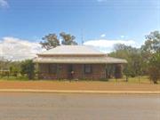
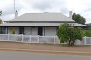
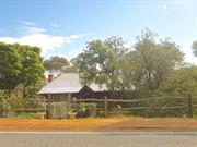
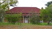
19-21 Newcastle St York
MI No: Y88
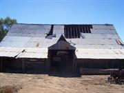
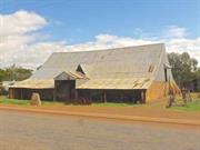
Marwicks Barn
York
Avon Arc
Constructed from 1876
| Type | Status | Date | Documents |
|---|---|---|---|
| Heritage List | Adopted | 25 Nov 2019 | |
| State Register | Registered | 23 Nov 2001 | HCWebsite.Listing+ListingDocument, HCWebsite.Listing+ListingDocument |
| Type | Status | Date | Documents |
|---|---|---|---|
| (no listings) |
| Type | Status | Date | Grading/Management | |
|---|---|---|---|---|
| Category | ||||
| Local Heritage Survey | Adopted | 25 Nov 2019 | Grade A | |
| Register of the National Estate | Permanent | 21 Mar 1978 | ||
| Aboriginal Heritage Sites Register | Recorded | |||
| Classified by the National Trust | Classified | 05 Mar 1985 | ||
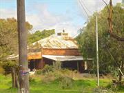
Poor condition
| Library Id | Title | Medium | Year Of Publication |
|---|---|---|---|
| 8390 | Marwick's Shed, York. Conservation works. Final report. | Conservation works report | 2007 |
| 9823 | Marwick's shed, York | Conservation works report | 2011 |
| 4487 | The shed (Marwick's) : 19-21 Newcastle Street, York, W.A. : conservation plan. | Heritage Study {Cons'n Plan} | 1999 |
| 5403 | Marwick's Shed, York : a report on the conservation works (final report). | Conservation works report | 2001 |
| 9382 | Report on Marwick's shed & cart shed | Conservation works report | 2009 |
| 6497 | Marwick's Shed York : conservation works (final report). | Conservation works report | 2003 |
Individual Building or Group
| Epoch | General | Specific |
|---|---|---|
| Present Use | FARMING\PASTORAL | Shed or Barn |
| Original Use | FARMING\PASTORAL | Shed or Barn |
| Style |
|---|
| Vernacular |
| Type | General | Specific |
|---|---|---|
| Roof | METAL | Corrugated Iron |
| Wall | STONE | Other Stone |
| General | Specific |
|---|---|
| OCCUPATIONS | Commercial & service industries |
| TRANSPORT & COMMUNICATIONS | Road transport |
| OCCUPATIONS | Rural industry & market gardening |
This information is provided voluntarily as a public service. The information provided is made available in good faith and is derived from sources believed to be reliable and accurate. However, the information is provided solely on the basis that readers will be responsible for making their own assessment of the matters discussed herein and are advised to verify all relevant representations, statements and information.
Constructed from 1876
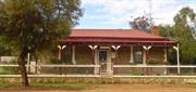
Marwick’s Shed is significant as a rare example of local 19th century vernacular construction techniques that utilise a timber structure to create a large volume without internal load-bearing walls. It exemplifies the strategic location of York (and Newcastle Street) as a route for transporting supplies to the goldfields prior to the completion of the Perth-Coolgardie railway line. The place functioned as an early form of depot for William Marwick's York-based road haulage business and as such is a memorial to the lives of William Marwick (snr) and his descendants who have played a leading role in the civic and business affairs of York for over 125 years. The building has a rustic appearance having acquired patina through many years of exposure to the elements, serving as a local landmark. It is of considerable significance to the historic townscape of York.
Marwick’s Shed is a large timber framed vernacular building with relatively low masonry external walls and a dominant pitched roof clad in galvanised corrugated iron. It is a rare example of local 19th century vernacular construction techniques, particularly the employment of a timber structure to create a large volume without internal load-bearing walls. It is a rare building type. Few vernacular structures of similar form and age are known to exist in Western Australia.
Samuel Evans Burges of Tipperary owned the site during which time William Marwick worked for and was closely associated with him, until Burges left in the state 1897. In 1899 the land was formerly transferred to William Marwick and sons. By which time, the 1876 building had been utilised for over 20 years as a storage and stabling facility for William Marwick’s transport and trading business. As farming became a more central focus of the family business in the early 1900s, the “Shed” became the central base for the management of their various properties. However by the 1960s, that was no longer practical and the place was mostly vacant and deteriorated. Gordon Marwick, the owner, is a great grandson of William Marwick, and resides directly opposite the “Shed” and has undertaken several stages of conservation works and storm repairs in recent decades.
Integrity: Fair Authenticity: Fair
Fair
This information is provided voluntarily as a public service. The information provided is made available in good faith and is derived from sources believed to be reliable and accurate. However, the information is provided solely on the basis that readers will be responsible for making their own assessment of the matters discussed herein and are advised to verify all relevant representations, statements and information.
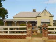
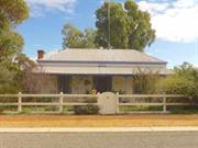
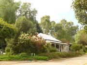
22 Newcastle St York
Lot 307.
Elm House
York
Avon Arc
Constructed from 1901
| Type | Status | Date | Documents |
|---|---|---|---|
| Heritage List | Adopted | 25 Nov 2019 |
| Type | Status | Date | Documents |
|---|---|---|---|
| (no listings) |
| Type | Status | Date | Grading/Management | |
|---|---|---|---|---|
| Category | ||||
| Local Heritage Survey | Adopted | 25 Nov 2019 | Grade B | |
| Name | Type | Year From | Year To |
|---|---|---|---|
| Darlington & McDonald | Architect | - | - |
Individual Building or Group
| Epoch | General | Specific |
|---|---|---|
| Present Use | RESIDENTIAL | Single storey residence |
This information is provided voluntarily as a public service. The information provided is made available in good faith and is derived from sources believed to be reliable and accurate. However, the information is provided solely on the basis that readers will be responsible for making their own assessment of the matters discussed herein and are advised to verify all relevant representations, statements and information.
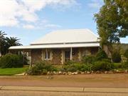
Constructed from 1901
Residence, 22 Newcastle Street is an example of Federation Bungalow architectural style, designed by an architect, and a part of the development on the east side of the Avon River, and in Newcastle Street in particular. It was associated with the Marwick family and makes a contribution to the historical townscape of York.
Single storey residence. Main roof has a hipped roof. The front and north side veranda has a bullnose roof supported by timber posts. The random coursed stone walls are white-line pointed. There are rendered quoins to the window and door openings. The symmetrical frontage shows a central entry flanked by a pairs of casement windows on the north side, and replacement aluminium framed window on the other side.
Designed by architects for William Marwick jnr in 1901.
Integrity: Moderate/High Authenticity: Moderate
Fair
This information is provided voluntarily as a public service. The information provided is made available in good faith and is derived from sources believed to be reliable and accurate. However, the information is provided solely on the basis that readers will be responsible for making their own assessment of the matters discussed herein and are advised to verify all relevant representations, statements and information.
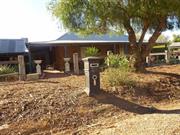
24 Newcastle St York
Lot 308
York
Avon Arc
| Type | Status | Date | Documents |
|---|---|---|---|
| Heritage List | Adopted | 25 Nov 2019 |
| Type | Status | Date | Documents |
|---|---|---|---|
| (no listings) |
| Type | Status | Date | Grading/Management | |
|---|---|---|---|---|
| Category | ||||
| Local Heritage Survey | Adopted | 25 Nov 2019 | Grade B | |
Individual Building or Group
| Epoch | General | Specific |
|---|---|---|
| Present Use | RESIDENTIAL | Single storey residence |
This information is provided voluntarily as a public service. The information provided is made available in good faith and is derived from sources believed to be reliable and accurate. However, the information is provided solely on the basis that readers will be responsible for making their own assessment of the matters discussed herein and are advised to verify all relevant representations, statements and information.
Constructed from 1870, Constructed from 1900
Residence, 24 Newcastle Street represents different stages of development; stone building and Federation residence with contemporary additions. It is closely associated with the Marwick family and in particular prominent local identity, Gordon Marwick. It is a part of the early and ongoing development on the east side of the Avon River, and in Newcastle Street in particular. It represents a significant contribution to the history and historical townscape of York.
The modest scale stone building has a simple hipped roof that extends over the perimeter veranda, curving similar to a bullnose at the outer edge where it is supported by timber posts. The residence is set back a considerable distance from the road, aligned with the stone building, with several mature palm trees in the front setback. The single storey residence is elevated on a stone foundation, partially rendered, and some original areas showing it was pointed. The face brick walls are painted. The roof is hipped with a protruding front gable, with a veranda on the recessed front and along the north side. The veranda timber posts with brackets and vertical spaced timber balustrade. There are extensive additions to the rear and south side of the residence.
Marwick associations. Linked with Marwick’s Shed located opposite in Newcastle Street.
Integrity: High Authenticity: Moderate/High
Fair/good
This information is provided voluntarily as a public service. The information provided is made available in good faith and is derived from sources believed to be reliable and accurate. However, the information is provided solely on the basis that readers will be responsible for making their own assessment of the matters discussed herein and are advised to verify all relevant representations, statements and information.
25 Newcastle St York
Lot 128
York
Avon Arc
| Type | Status | Date | Documents |
|---|---|---|---|
| Heritage List | Adopted | 25 Nov 2019 |
| Type | Status | Date | Documents |
|---|---|---|---|
| (no listings) |
| Type | Status | Date | Grading/Management | |
|---|---|---|---|---|
| Category | ||||
| Local Heritage Survey | Adopted | 25 Nov 2019 | Grade B | |
Individual Building or Group
| Epoch | General | Specific |
|---|---|---|
| Present Use | RESIDENTIAL | Single storey residence |
This information is provided voluntarily as a public service. The information provided is made available in good faith and is derived from sources believed to be reliable and accurate. However, the information is provided solely on the basis that readers will be responsible for making their own assessment of the matters discussed herein and are advised to verify all relevant representations, statements and information.
Constructed from 1865
Residence, 25 Newcastle Street is a good representative example of Victorian Georgian architectural style and a part of the early development on the east side of the Avon River, and in Newcastle Street in particular. It makes a significant contribution to the historical townscape of York.
Stone construction, with a hipped roof.
Built for William Marwick jnr in 1901. Appears to be the same as the Architect designed residence at 22 Newcastle Street, also built for William Marwick jnr in 1901, although the windows are different.
Integrity: High Authenticity: Moderate/High
Fair/good
This information is provided voluntarily as a public service. The information provided is made available in good faith and is derived from sources believed to be reliable and accurate. However, the information is provided solely on the basis that readers will be responsible for making their own assessment of the matters discussed herein and are advised to verify all relevant representations, statements and information.
28 Newcastle St York
Lot 100
York
Avon Arc
| Type | Status | Date | Documents |
|---|---|---|---|
| Heritage List | Adopted | 25 Nov 2019 |
| Type | Status | Date | Documents |
|---|---|---|---|
| (no listings) |
| Type | Status | Date | Grading/Management | |
|---|---|---|---|---|
| Category | ||||
| Local Heritage Survey | Adopted | 25 Nov 2019 | Grade B | |
Individual Building or Group
| Epoch | General | Specific |
|---|---|---|
| Original Use | RESIDENTIAL | Single storey residence |
This information is provided voluntarily as a public service. The information provided is made available in good faith and is derived from sources believed to be reliable and accurate. However, the information is provided solely on the basis that readers will be responsible for making their own assessment of the matters discussed herein and are advised to verify all relevant representations, statements and information.
Constructed from 1910
Residence, 28 Newcastle Street is a good representative example of an uncommon intact timber-clad Federation Bungalow that is part of the development on the east side of the Avon River, and in Newcastle Street in particular that makes a significant contribution to the historical townscape of York.
The single storey painted weatherboard residence has a predominantly hipped roof and protruding front gable. The return front veranda that extends down the north side has a bullnose roof and is enclosed, in the same boards, to align with the front of the main wall. The gable features a rectangular louvred vent in the apex and a set of three casement windows with a timber framed awning over. The recessed front veranda wall has a set of French doors with a fanlight above, and the entry door set has sidelights and a fanlight.
Integrity: High Authenticity: Moderate/High
Good
This information is provided voluntarily as a public service. The information provided is made available in good faith and is derived from sources believed to be reliable and accurate. However, the information is provided solely on the basis that readers will be responsible for making their own assessment of the matters discussed herein and are advised to verify all relevant representations, statements and information.
29 Newcastle St York
York
Avon Arc
Constructed from 1865
| Type | Status | Date | Documents |
|---|---|---|---|
| Heritage List | Adopted | 25 Nov 2019 |
| Type | Status | Date | Documents |
|---|---|---|---|
| (no listings) |
| Type | Status | Date | Grading/Management | |
|---|---|---|---|---|
| Category | ||||
| Local Heritage Survey | Adopted | 25 Nov 2019 | Grade B | |
Individual Building or Group
| Epoch | General | Specific |
|---|---|---|
| Original Use | RESIDENTIAL | Single storey residence |
| Present Use | RESIDENTIAL | Single storey residence |
| Type | General | Specific |
|---|---|---|
| Roof | METAL | Corrugated Iron |
| Wall | STONE | Other Stone |
| General | Specific |
|---|---|
| DEMOGRAPHIC SETTLEMENT & MOBILITY | Settlements |
This information is provided voluntarily as a public service. The information provided is made available in good faith and is derived from sources believed to be reliable and accurate. However, the information is provided solely on the basis that readers will be responsible for making their own assessment of the matters discussed herein and are advised to verify all relevant representations, statements and information.
Constructed from 1860
Stone Grange, 29 Newcastle Street is a unique Architect designed Victorian Rustic Gothic architectural style that was a part of the early development on the east side of the Avon River, and in Newcastle Street in particular. It is historically significant for the close association with Stephen Horgan, the Architect/Builder of the residence, who was also a Pensioner Guard. It is a landmark and makes a significant contribution to the history and the historical townscape of York.
Single storey stone construction with a steep pitched gable pavilion roof. The stone is random coursed with black-line pointing. There are face brick chimneys at each end of the roof. Reported as having a 7 metre high interior ceiling at ridge height.
Stephen Horgan was a Pensioner Guard.
High
Good
| Ref ID No | Ref Name | Ref Source | Ref Date |
|---|---|---|---|
| Heritage Council’s Website | Heritage Council of WA |
This information is provided voluntarily as a public service. The information provided is made available in good faith and is derived from sources believed to be reliable and accurate. However, the information is provided solely on the basis that readers will be responsible for making their own assessment of the matters discussed herein and are advised to verify all relevant representations, statements and information.
37 Newcastle St York
Lot 124
York
Avon Arc
| Type | Status | Date | Documents |
|---|---|---|---|
| Heritage List | Adopted | 25 Nov 2019 |
| Type | Status | Date | Documents |
|---|---|---|---|
| (no listings) |
| Type | Status | Date | Grading/Management | |
|---|---|---|---|---|
| Category | ||||
| Local Heritage Survey | Adopted | 25 Nov 2019 | Grade B | |
| Municipal Inventory | Adopted | 25 Nov 2019 | Grade B | |
Individual Building or Group
| Epoch | General | Specific |
|---|---|---|
| Present Use | RESIDENTIAL | Single storey residence |
This information is provided voluntarily as a public service. The information provided is made available in good faith and is derived from sources believed to be reliable and accurate. However, the information is provided solely on the basis that readers will be responsible for making their own assessment of the matters discussed herein and are advised to verify all relevant representations, statements and information.
Constructed from 1950
Residence, 37 Newcastle Street is a good representative example of Post-war austerity with curved corners providing a moderne touch. It represents part of the post war development in York and makes a contribution to the historical townscape.
Single storey residence has a simple hipped roof clad with concrete tiles. The two-room frontage typical of the austerity style, features curved corners and moulded horizontal lines to provide a moderne aesthetic. The two rooms flank a central recessed entry.
The Rate books show that Thomas Burges owned the land in 1893.
Integrity: High Authenticity: Moderate/High
Fair
This information is provided voluntarily as a public service. The information provided is made available in good faith and is derived from sources believed to be reliable and accurate. However, the information is provided solely on the basis that readers will be responsible for making their own assessment of the matters discussed herein and are advised to verify all relevant representations, statements and information.
42 Newcastle St York
Lot 1
York
Avon Arc
| Type | Status | Date | Documents |
|---|---|---|---|
| Heritage List | Adopted | 25 Nov 2019 |
| Type | Status | Date | Documents |
|---|---|---|---|
| (no listings) |
| Type | Status | Date | Grading/Management | |
|---|---|---|---|---|
| Category | ||||
| Local Heritage Survey | Adopted | 25 Nov 2019 | Grade B | |
Individual Building or Group
| Epoch | General | Specific |
|---|---|---|
| Present Use | RESIDENTIAL | Single storey residence |
This information is provided voluntarily as a public service. The information provided is made available in good faith and is derived from sources believed to be reliable and accurate. However, the information is provided solely on the basis that readers will be responsible for making their own assessment of the matters discussed herein and are advised to verify all relevant representations, statements and information.
Constructed from 1880
Residence, 42 Newcastle Street is a good representative example of Victorian Georgian architectural style that is part of the early development on the east side of the Avon River, and in Newcastle Street in particular. It makes a significant contribution to the historical townscape of York.
Single storey with a simple hipped roof and separate hipped skillion veranda to the front and south side supported by square stop chamfered timber posts. The symmetrical frontage has a central front door flanked by single double-hung sash windows. Tall square painted face brick chimneys with brick corbels are evident both sides of the roof.
The earliest rate book in 1893 lists Alfred Beard (labourer) as the owner, through to 1906 when he is listed as a farmer. In 1908 and 1910 Charlotte Eyre (widow) was listed as “occupier.” Alfred Beard died in 1930 (b.1862) at which time he lived at Meares Siding near Brookton. Part of his probate of the will bequeathed £25 to various members of the Marwick family including Miss Eleanor, and Mr Joseph Walker, and “certain real estate” in York to Joseph Walker Marwick, and interests in his business Beard and Marwick, to the children of Warren Marwick in equal shares.
Integrity: High Authenticity: Moderate/High
Good
This information is provided voluntarily as a public service. The information provided is made available in good faith and is derived from sources believed to be reliable and accurate. However, the information is provided solely on the basis that readers will be responsible for making their own assessment of the matters discussed herein and are advised to verify all relevant representations, statements and information.
49 Newcastle St York
Lot 120
York
Avon Arc
| Type | Status | Date | Documents |
|---|---|---|---|
| (no listings) |
| Type | Status | Date | Documents |
|---|---|---|---|
| (no listings) |
| Type | Status | Date | Grading/Management | |
|---|---|---|---|---|
| Category | ||||
| Local Heritage Survey | Adopted | 25 Nov 2019 | Grade C | |
Individual Building or Group
| Epoch | General | Specific |
|---|---|---|
| Present Use | RESIDENTIAL | Single storey residence |
This information is provided voluntarily as a public service. The information provided is made available in good faith and is derived from sources believed to be reliable and accurate. However, the information is provided solely on the basis that readers will be responsible for making their own assessment of the matters discussed herein and are advised to verify all relevant representations, statements and information.
Constructed from 1910
Residence, 49 Newcastle Street is an intact, although in poor condition, example of a Federation working class weatherboard residence that is a part of the development on the east side of the Avon River, and in Newcastle Street in particular. It makes a significant contribution to the historical townscape of York.
The single storey weatherboard residence is mostly obscured from view by mature planting around the property. The weatherboards remain unpainted as original. The simple hipped roof is separate from the front bullnose veranda. There is a lean to on the north side.
The rate books list F. Cahill (Falconer) as owner of the land in 1899, and Robert Reid (labourer) as owner of the house and land in 1914.
Integrity: High Authenticity: Moderate/High
Poor/Fair
This information is provided voluntarily as a public service. The information provided is made available in good faith and is derived from sources believed to be reliable and accurate. However, the information is provided solely on the basis that readers will be responsible for making their own assessment of the matters discussed herein and are advised to verify all relevant representations, statements and information.
60 Newcastle St York
Fmr 53 Newcastle St
York
Avon Arc
Constructed from 1905, Constructed from 1860
| Type | Status | Date | Documents |
|---|---|---|---|
| Heritage List | Adopted | 25 Nov 2019 |
| Type | Status | Date | Documents |
|---|---|---|---|
| (no listings) |
| Type | Status | Date | Grading/Management | |
|---|---|---|---|---|
| Category | ||||
| Local Heritage Survey | Adopted | 25 Nov 2019 | Grade B | |
Individual Building or Group
| Epoch | General | Specific |
|---|---|---|
| Present Use | RESIDENTIAL | Single storey residence |
| Original Use | RESIDENTIAL | Single storey residence |
| Style |
|---|
| Victorian Georgian |
| Type | General | Specific |
|---|---|---|
| Roof | METAL | Corrugated Iron |
| Wall | BRICK | Common Brick |
| General | Specific |
|---|---|
| OCCUPATIONS | Rural industry & market gardening |
This information is provided voluntarily as a public service. The information provided is made available in good faith and is derived from sources believed to be reliable and accurate. However, the information is provided solely on the basis that readers will be responsible for making their own assessment of the matters discussed herein and are advised to verify all relevant representations, statements and information.
Constructed from 1975, Constructed from 1850, Constructed from 1907
Residence, 60 Newcastle Street is a significant example of the development of a site with associations since the early settlement in York. The close association with Pensioner Guard James Whitely, and the ways of life that are no longer practiced, including the possibility of it being a former Inn, are of considerable historical significance. The building evidences several periods of development and demonstrates the periods of development on the east side of the Avon River, and in Newcastle Street in particular. It makes a significant contribution to the history and the historical townscape of York.
Two single storey buildings are defined and connected. The original c.1850 residence faces north on the north side of the c.1907 Federation addition that presents to the street frontage. The c.1850 form and fabric is identified by the modest scale, hipped roof, front veranda supported by square timber posts. The c.1907 Federation addition presents a facetted gable bay to the street frontage. It is rendered masonry with a hipped roof and gable front feature.
Irish Pensioner Guard James Whitely and his wife Johannah were the first owners of the cottage. Originally shingled. It is claimed there was a cellar used for curing meats, and the possibility that the place was a coaching house or inn at some stage.
Integrity: High Authenticity: Moderate/High
Fair/good
This information is provided voluntarily as a public service. The information provided is made available in good faith and is derived from sources believed to be reliable and accurate. However, the information is provided solely on the basis that readers will be responsible for making their own assessment of the matters discussed herein and are advised to verify all relevant representations, statements and information.
71 Newcastle St York
Lot 114
York
Avon Arc
Constructed from 1890 to 1900
| Type | Status | Date | Documents |
|---|---|---|---|
| Heritage List | Adopted | 25 Nov 2019 |
| Type | Status | Date | Documents |
|---|---|---|---|
| (no listings) |
| Type | Status | Date | Grading/Management | |
|---|---|---|---|---|
| Category | ||||
| Local Heritage Survey | Adopted | 25 Nov 2019 | Grade B | |
Individual Building or Group
| Epoch | General | Specific |
|---|---|---|
| Present Use | RESIDENTIAL | Single storey residence |
This information is provided voluntarily as a public service. The information provided is made available in good faith and is derived from sources believed to be reliable and accurate. However, the information is provided solely on the basis that readers will be responsible for making their own assessment of the matters discussed herein and are advised to verify all relevant representations, statements and information.
Constructed from 1913
Residence, 71 Newcastle Street is a good representative and uncommon example of an intact weatherboard Federation bungalow that is part of the development on the east side of the Avon River, and Newcastle Street in particular. It makes a significant contribution to the historical townscape of York.
Single storey with a simple hipped roof and separate skillion veranda to the front. Clad with painted weatherboards. Symmetrical frontage with a central front door with sidelights and fanlight, flanked by single double-hung sash windows.
The rate books list JM Ferguson (merchant) as owner of the land between 1899 and 1910, and William Elliott (miller) as owner of the house and land in 1913.
Integrity: High Authenticity: Moderate/High
Good
This information is provided voluntarily as a public service. The information provided is made available in good faith and is derived from sources believed to be reliable and accurate. However, the information is provided solely on the basis that readers will be responsible for making their own assessment of the matters discussed herein and are advised to verify all relevant representations, statements and information.
18 Newcastle Street York
Monkton
York
Avon Arc
| Type | Status | Date | Documents |
|---|---|---|---|
| Heritage List | Adopted | 25 Nov 2019 |
| Type | Status | Date | Documents |
|---|---|---|---|
| (no listings) |
| Type | Status | Date | Grading/Management | |
|---|---|---|---|---|
| Category | ||||
| (no listings) | ||||
Individual Building or Group
| Epoch | General | Specific |
|---|---|---|
| Original Use | RESIDENTIAL | Single storey residence |
| Present Use | RESIDENTIAL | Single storey residence |
| Style |
|---|
| Victorian Georgian |
| Type | General | Specific |
|---|---|---|
| Roof | METAL | Corrugated Iron |
| Wall | STONE | Local Stone |
This information is provided voluntarily as a public service. The information provided is made available in good faith and is derived from sources believed to be reliable and accurate. However, the information is provided solely on the basis that readers will be responsible for making their own assessment of the matters discussed herein and are advised to verify all relevant representations, statements and information.
Constructed from 1880
Residence, 18 Newcastle Street is a good representative example of Victorian Georgian architectural style and a part of the early development on the east side of the Avon River, and in Newcastle Street in particular. It makes a significant contribution to the historical townscape of York.
There is a minimal setback from the front boundary that has a timber framed decorative wire fence with central gate and path to the single storey residence. The main roof has a low-pitched hipped that breaks pitch. The front veranda, supported by square timber posts and brackets, has a separate hipped roof. The stone walls are constructed in random courses and are pointed with rendered surrounds to the window and door openings and quoins on the corners of the front wall. The symmetrical frontage shows a central entry flanked by single double-hung sash multi-paned windows. Face brick corbelled chimneys
Moderate/High Degree Moderate/High Degree
Fair/Good
| Reserve | Lot/Location | Plan/Diagram | Vol/Folio |
|---|---|---|---|
| 420 | 301164 | 1553/056 |
This information is provided voluntarily as a public service. The information provided is made available in good faith and is derived from sources believed to be reliable and accurate. However, the information is provided solely on the basis that readers will be responsible for making their own assessment of the matters discussed herein and are advised to verify all relevant representations, statements and information.
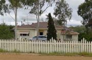
North Rd York
York
Avon Arc
Constructed from 1910
| Type | Status | Date | Documents |
|---|---|---|---|
| Heritage List | Adopted | 25 Nov 2019 |
| Type | Status | Date | Documents |
|---|---|---|---|
| (no listings) |
| Type | Status | Date | Grading/Management | |
|---|---|---|---|---|
| Category | ||||
| Local Heritage Survey | Adopted | 25 Nov 2019 | Grade B | |
Individual Building or Group
| Epoch | General | Specific |
|---|---|---|
| Present Use | FARMING\PASTORAL | Homestead |
| Original Use | FARMING\PASTORAL | Homestead |
| Type | General | Specific |
|---|---|---|
| Wall | BRICK | Common Brick |
| Roof | METAL | Corrugated Iron |
| General | Specific |
|---|---|
| OCCUPATIONS | Grazing, pastoralism & dairying |
This information is provided voluntarily as a public service. The information provided is made available in good faith and is derived from sources believed to be reliable and accurate. However, the information is provided solely on the basis that readers will be responsible for making their own assessment of the matters discussed herein and are advised to verify all relevant representations, statements and information.
Constructed from 1910
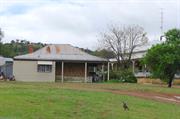
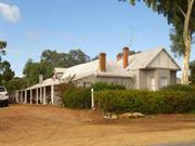
Mt Bakewell Homestead is historically significant for the Monger family associations and is representative of an 1890s farm dwelling.
Located at the foot of Mt Bakewell at opposite the racecourse. Single storey with a high-pitched roof that extends over the surrounding verandas. The perimeter balustrade is masonry with masonry base pillars and square timber posts. The central (symmetrical) frontage has a sweeping curved concrete staircase.
In 1913 Mt Bakewell Homestead was advertised for sale: 615 acres with a comfortable stone and brick homestead of 7 rooms at Executors instructions for the Estate of S Monger. Edward Staunton Monger (1870-1936) (who owned adjoining land) managed the farm for his mother Mrs JH (Mary) Monger, after his father JH Monger died.
This information is provided voluntarily as a public service. The information provided is made available in good faith and is derived from sources believed to be reliable and accurate. However, the information is provided solely on the basis that readers will be responsible for making their own assessment of the matters discussed herein and are advised to verify all relevant representations, statements and information.
North Rd York
Address contains: Lots 90, 91, 97-106, 109 & 110 North Rd, York. VFL - 21/6/2011. Sometimes known as 90 Spencers Brook Rd, York.
including Grandstand
York
Avon Arc
Constructed from 1924 to 1991
| Type | Status | Date | Documents |
|---|---|---|---|
| Heritage List | Adopted | 25 Nov 2019 | |
| State Register | Registered | 03 Jun 2005 | HCWebsite.Listing+ListingDocument, HCWebsite.Listing+ListingDocument |
| Type | Status | Date | Documents |
|---|---|---|---|
| (no listings) |
| Type | Status | Date | Grading/Management | |
|---|---|---|---|---|
| Category | ||||
| Local Heritage Survey | Adopted | 25 Nov 2019 | Grade A | |
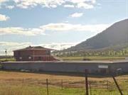
Overall York-Beverley Racecourse was in fair to good condition at the time of assessment. The structures were mostly sound, except for the committee rooms (former) that is in a derelict condition. The Grandstand was demolished in 2011.
| Library Id | Title | Medium | Year Of Publication |
|---|---|---|---|
| 4774 | Grandstand, York Racecourse : conservaton plan. | Heritage Study {Cons'n Plan} | 1998 |
Individual Building or Group
| Epoch | General | Specific |
|---|---|---|
| Original Use | SOCIAL\RECREATIONAL | Grandstand |
| Original Use | SOCIAL\RECREATIONAL | Other Sports Building |
| Present Use | SOCIAL\RECREATIONAL | Grandstand |
| Present Use | SOCIAL\RECREATIONAL | Other Sports Building |
| Style |
|---|
| Vernacular |
| Type | General | Specific |
|---|---|---|
| Wall | METAL | Corrugated Iron |
| Roof | METAL | Corrugated Iron |
| Wall | TIMBER | Weatherboard |
| Wall | BRICK | Common Brick |
| Wall | METAL | Steel |
| General | Specific |
|---|---|
| SOCIAL & CIVIC ACTIVITIES | Community services & utilities |
| SOCIAL & CIVIC ACTIVITIES | Sport, recreation & entertainment |
This information is provided voluntarily as a public service. The information provided is made available in good faith and is derived from sources believed to be reliable and accurate. However, the information is provided solely on the basis that readers will be responsible for making their own assessment of the matters discussed herein and are advised to verify all relevant representations, statements and information.
Constructed from 1924, Constructed from 1991
Since 1846 this facility has been the home to the York Jockey Club, which is the oldest regional race club in Australia and is the oldest operating regional racetrack in Australia. This is one of the few remaining regional racecourses incorporating timber buildings and as a racecourse constructed in the interwar period. Reflects the growth and development of York into an important regional centre during the second half of the 19th century and the early 20th century.
Located at the foot of Mt Bakewell, in a rural picturesque setting, is the racecourse, grandstand, tote building and bar area, pavilion, committee rooms, stable shelters and associated yards, track elements and grounds.
Integrity: Good Authenticity: Good
Good
| Ref ID No | Ref Name | Ref Source | Ref Date |
|---|---|---|---|
| Heritage Council’s Website. | Heritage Council of WA |
| Owner | Category |
|---|---|
| York Beverley Turf Club Inc | Other Private |
This information is provided voluntarily as a public service. The information provided is made available in good faith and is derived from sources believed to be reliable and accurate. However, the information is provided solely on the basis that readers will be responsible for making their own assessment of the matters discussed herein and are advised to verify all relevant representations, statements and information.
Northam - York Rd York
Craig St Intersection
York
Avon Arc
| Type | Status | Date | Documents |
|---|---|---|---|
| Heritage List | Adopted | 25 Nov 2019 |
| Type | Status | Date | Documents |
|---|---|---|---|
| (no listings) |
| Type | Status | Date | Grading/Management | |
|---|---|---|---|---|
| Category | ||||
| Local Heritage Survey | Adopted | 25 Nov 2019 | Grade B | |
Other Built Type
| Epoch | General | Specific |
|---|---|---|
| Original Use | OTHER | Other |
| Type | General | Specific |
|---|---|---|
| Other | STONE | Local Stone |
This information is provided voluntarily as a public service. The information provided is made available in good faith and is derived from sources believed to be reliable and accurate. However, the information is provided solely on the basis that readers will be responsible for making their own assessment of the matters discussed herein and are advised to verify all relevant representations, statements and information.
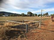
Constructed from 1877
Northam Road Well is one of several wells that the York Municipal Council constructed to provide the town’s community with water. Northam Road well, and others, were a critical source of water to particularly during drought periods. It has been retained in good condition, (maybe the only remaining intact well?) and makes a significant contribution to informing the historical development of the town of York.
The well is located on the road verge and is covered with a metal grate at ground level with a metal pipe-rail surrounding barrier. The well is stone lined and appears to be in good condition.
In January 1878, during along hot summer and a long that drought continued, there was mention of well sinking taking place throughout the areas everyone’s water supplies are exhausted. The report states “By the bye we ought to feel under a great obligation to our commends the late Municipal Council for their energy last year in sinking an almost inexhaustible well of pure fresh water. It supplies pretty well all of the town; there is great traffic to and from it all day through, and altogether it is a blessing in the absence of rain.” In 1896, it was report in the Council Minutes that Cr Harvey stated, “that several ratepayers had pointed out to him that the necessity of staining the well in the Northam road as a portion of it had fallen in.” The Council resolved to advise the Works Committee to inspect the well. A letter was also tabled from Dr Davis, the Health Officer addressed to the Secretary of the Board advising of his examination of the water for the well, and for a rough test of seven samples, showed they were “absolutely unfit for human consumption. I should recommend these waters be boiled before using.” It was resolved to advertise in The Chronicle warning people to boil the water as a precaution before use.
Integrity: Low Authenticity: High
Fair/good
This information is provided voluntarily as a public service. The information provided is made available in good faith and is derived from sources believed to be reliable and accurate. However, the information is provided solely on the basis that readers will be responsible for making their own assessment of the matters discussed herein and are advised to verify all relevant representations, statements and information.
57 Northam Rd York
York
Avon Arc
Constructed from 1870
| Type | Status | Date | Documents |
|---|---|---|---|
| Heritage List | Adopted | 25 Nov 2019 |
| Type | Status | Date | Documents |
|---|---|---|---|
| (no listings) |
| Type | Status | Date | Grading/Management | |
|---|---|---|---|---|
| Category | ||||
| Local Heritage Survey | Adopted | 25 Nov 2019 | Grade B | |
Individual Building or Group
| Epoch | General | Specific |
|---|---|---|
| Original Use | FARMING\PASTORAL | Homestead |
| Present Use | RESIDENTIAL | Single storey residence |
| Type | General | Specific |
|---|---|---|
| Roof | METAL | Corrugated Iron |
| Wall | BRICK | Common Brick |
| Wall | STONE | Other Stone |
| General | Specific |
|---|---|
| OCCUPATIONS | Grazing, pastoralism & dairying |
This information is provided voluntarily as a public service. The information provided is made available in good faith and is derived from sources believed to be reliable and accurate. However, the information is provided solely on the basis that readers will be responsible for making their own assessment of the matters discussed herein and are advised to verify all relevant representations, statements and information.
Constructed from 1870
Prunster’s Cottage, 2974 Northam - York Road is an unusual, if not rare example of dichromatic (reverse tone) Flemish bond brickwork, with the darker of the contrasting colour in the stretcher rather than the header bricks, providing a very different aesthetic of considerable significance. The decorative timber on the entry gable is also unusual, making this example of Victorian Georgian architecture quite special. Historically significant for associations with the Prunster and Marwick families. It makes a considerable contribution to the historical townscape of York.
One residence was evident on the site: Set in a cottage garden with a short setback from a rustic timber front boundary fence, the single storey residence is a brick construction with distinctive reverse tone Flemish bond brickwork to the symmetrical front faced. It features dark brick stretchers brick, unlike the usual dichromatic brickwork that has dark brick headers. The simple hipped roof break pitch over the front veranda that is supported by stop chamfered timber posts and features a central gable delineating the entry. The gable is detailed in delicate timbers on the barge boards with an inverted finial at the apex. The central front door is four panelled with a distinctive fanlight with geometric panes of glass. 36 Suburban Road also has the same Flemish bond brickwork.
The Prunster and Marwick families had associations with the place. The record states there are two cottages on the site Prunster’s (brick and iron) and Barnes’ (stone and iron) and that they were part of a farm that was subdivided. The property includes an early orchard site. A carrier business once operated from the site.
High
Good
This information is provided voluntarily as a public service. The information provided is made available in good faith and is derived from sources believed to be reliable and accurate. However, the information is provided solely on the basis that readers will be responsible for making their own assessment of the matters discussed herein and are advised to verify all relevant representations, statements and information.
2995 Northam -York Road York
Fmr 40
York
Avon Arc
| Type | Status | Date | Documents |
|---|---|---|---|
| Heritage List | Adopted | 25 Nov 2019 |
| Type | Status | Date | Documents |
|---|---|---|---|
| (no listings) |
| Type | Status | Date | Grading/Management | |
|---|---|---|---|---|
| Category | ||||
| (no listings) | ||||
Individual Building or Group
| Epoch | General | Specific |
|---|---|---|
| Original Use | RESIDENTIAL | Single storey residence |
| Present Use | RESIDENTIAL | Single storey residence |
| Style |
|---|
| Victorian Georgian |
| Type | General | Specific |
|---|---|---|
| Wall | STONE | Local Stone |
| Roof | TILE | Other Tile |
This information is provided voluntarily as a public service. The information provided is made available in good faith and is derived from sources believed to be reliable and accurate. However, the information is provided solely on the basis that readers will be responsible for making their own assessment of the matters discussed herein and are advised to verify all relevant representations, statements and information.
Constructed from 1885
Residence, 2995 Northam York Road is a Victorian Georgian architectural style that represents a part of the early development east of the Avon River and contributes to the historic townscape of York.
Single storey residence. Simple hipped roof clad with decramastic (metal) tiles. The front veranda skillion roof is supported by square timber posts. The stonewalls are random coursed with evidence of white-line pointing, with face brick quoins to window and door openings and the corners of the front wall. Symmetrical front with central front door flanked by windows. The front door has 2 panels with multi-paned glazing above and a fanlight also with multi-pane glass. Square face brick chimneys at each end of the roof have a corbelled detail.
High Degree Moderate/High Degree
Fair/Good
| Reserve | Lot/Location | Plan/Diagram | Vol/Folio |
|---|---|---|---|
| 283 | 209827 | 1964/932 |
This information is provided voluntarily as a public service. The information provided is made available in good faith and is derived from sources believed to be reliable and accurate. However, the information is provided solely on the basis that readers will be responsible for making their own assessment of the matters discussed herein and are advised to verify all relevant representations, statements and information.
3029 Northam-York Rd York
in MI as 12 Northam Rd York
York
Avon Arc
Constructed from 1868
| Type | Status | Date | Documents |
|---|---|---|---|
| Heritage List | Adopted | 25 Nov 2019 |
| Type | Status | Date | Documents |
|---|---|---|---|
| (no listings) |
| Type | Status | Date | Grading/Management | |
|---|---|---|---|---|
| Category | ||||
| Local Heritage Survey | Adopted | 25 Nov 2019 | Grade B | |
Individual Building or Group
| Epoch | General | Specific |
|---|---|---|
| Original Use | RESIDENTIAL | Single storey residence |
| Present Use | RESIDENTIAL | Single storey residence |
| Type | General | Specific |
|---|---|---|
| Wall | EARTH | Adobe {Mud Brick} |
| Roof | METAL | Corrugated Iron |
| Wall | TIMBER | Other Timber |
| General | Specific |
|---|---|
| DEMOGRAPHIC SETTLEMENT & MOBILITY | Settlements |
This information is provided voluntarily as a public service. The information provided is made available in good faith and is derived from sources believed to be reliable and accurate. However, the information is provided solely on the basis that readers will be responsible for making their own assessment of the matters discussed herein and are advised to verify all relevant representations, statements and information.
Constructed from 1890
Lott’s Cottage, 3029 Northam – York Road is a good representative example of Victorian Georgian architectural style that is part of the early development on the east side of the Avon River and makes a significant contribution to the historical townscape of York.
Single storey residence in a cottage garden setting. Simple hipped roof clad with corrugated iron and has separate hipped veranda with detailed timber valance. Symmetrical front with central front door flanked by single double hung sash windows.
Thomas Lott (1853-1906) son of John and Margaret Lott who arrived in 1837, married Emma Grigson in 1878 and they had 6 children. They are listed as farming at Wilberforce (1878-1889), and Wooregong.
Integrity: High Authenticity: Moderate/High
Fair/good
This information is provided voluntarily as a public service. The information provided is made available in good faith and is derived from sources believed to be reliable and accurate. However, the information is provided solely on the basis that readers will be responsible for making their own assessment of the matters discussed herein and are advised to verify all relevant representations, statements and information.
Oakover Rd York
SLKm 0.65 Map 2, VG2
MRWA 4169
York
Avon Arc
Constructed from 1897
| Type | Status | Date | Documents |
|---|---|---|---|
| (no listings) |
| Type | Status | Date | Documents |
|---|---|---|---|
| RHP - Does not warrant assessment | Current | 12 Nov 2004 |
| Type | Status | Date | Grading/Management | |
|---|---|---|---|---|
| Category | ||||
| Statewide Lge Timber Str Survey | Completed | 11 Dec 1998 | ||
Poor
Historic site
| Epoch | General | Specific |
|---|---|---|
| Original Use | Transport\Communications | Road: Bridge |
| Present Use | Transport\Communications | Road: Bridge |
| Type | General | Specific |
|---|---|---|
| Other | TIMBER | Other Timber |
| General | Specific |
|---|---|
| TRANSPORT & COMMUNICATIONS | Road transport |
| DEMOGRAPHIC SETTLEMENT & MOBILITY | Settlements |
This information is provided voluntarily as a public service. The information provided is made available in good faith and is derived from sources believed to be reliable and accurate. However, the information is provided solely on the basis that readers will be responsible for making their own assessment of the matters discussed herein and are advised to verify all relevant representations, statements and information.
2 Osnaburg Rd York
York
Avon Arc
Constructed from 1859
| Type | Status | Date | Documents |
|---|---|---|---|
| Heritage List | Adopted | 25 Nov 2019 |
| Type | Status | Date | Documents |
|---|---|---|---|
| RHP - To be assessed | Current | 26 Sep 2003 |
| Type | Status | Date | Grading/Management | |
|---|---|---|---|---|
| Category | ||||
| Local Heritage Survey | Adopted | 25 Nov 2019 | Grade B | |
The place has aesthetic value as a simple mud brick residence in the Victorian Georgian style.
The place has associations with the development of the York area since the mid nineteenth century.
The place has associations with the transportation of convicts to the colony in the 1850s, and in particular with the provision of land and accommodation for the pensioner guards and their families who accompanied them.
The place is a good example of an 1850s cottage in York, which is intact.
The place has rarity value as a residence of mud brick construction in the York townsite.
The residence is of mud brick construction with surrounding verandahs. The place has a CGI hipped roof, break pitch over the verandahs. There is a pavilion extension on the northwest side of the building which is connected by means of the verandah. Although this structure is of similar form and materials, it dates from the 1970s.
The Avon River valley was first explored by Ensign Robert Dale in July 1830. The district was declared open for settlement on 12 November 1830. 13 days later, notice was given that ‘a town to be called York will be laid out in a situation near Mount Blackwell’. The area initially developed as an agricultural district and by 1836, the nucleus of the township was in place. Subsequent to the transportation of the first convicts to the Swan River Colony in 1851, a convict depot was established in York to facilitate the completion of public works in the area. With the convicts came the Pensioner Guards; all of whom were granted land as part of their service. This place is said to have been constructed for a Pensioner Guard in c. 1859 by builder E. Ashworth.
High
Good
Individual Building or Group
| Epoch | General | Specific |
|---|---|---|
| Original Use | RESIDENTIAL | Single storey residence |
| Present Use | RESIDENTIAL | Single storey residence |
| Style |
|---|
| Victorian Georgian |
| Type | General | Specific |
|---|---|---|
| Roof | METAL | Corrugated Iron |
| Wall | EARTH | Adobe {Mud Brick} |
| General | Specific |
|---|---|
| DEMOGRAPHIC SETTLEMENT & MOBILITY | Settlements |
This information is provided voluntarily as a public service. The information provided is made available in good faith and is derived from sources believed to be reliable and accurate. However, the information is provided solely on the basis that readers will be responsible for making their own assessment of the matters discussed herein and are advised to verify all relevant representations, statements and information.
Constructed from 1859
Residence, 2 Onsaburg Road represents one of the few remaining vernacular builds in York. Located on the fringe of the town, it represents the use of local materials in the establishment of a dwelling on a farm property and makes a significant contribution to the historical variety of the built environment of the town of York.
Single storey residence. Main roof is hipped and breaks pitch over the perimeter veranda that is supported by square timber posts. The symmetrical frontage shows a central entry flanked by pairs of casement windows.
Claimed to be built by the owner, E Ashworth. At one time associated with the Avon Valley Historical Rose Garden.
Integrity: High Authenticity: Moderate/High
Fair/good
This information is provided voluntarily as a public service. The information provided is made available in good faith and is derived from sources believed to be reliable and accurate. However, the information is provided solely on the basis that readers will be responsible for making their own assessment of the matters discussed herein and are advised to verify all relevant representations, statements and information.