Local Government
York
Region
Avon Arc
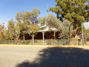
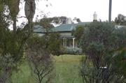
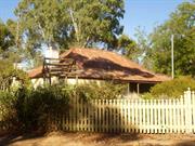
4 Pool St York
York
Avon Arc
Constructed from 1859
| Type | Status | Date | Documents |
|---|---|---|---|
| Heritage List | Adopted | 25 Nov 2019 |
| Type | Status | Date | Documents |
|---|---|---|---|
| RHP - To be assessed | Current | 27 Jun 2003 |
| Type | Status | Date | Grading/Management | |
|---|---|---|---|---|
| Category | ||||
| Municipal Inventory | Adopted | 31 Dec 1995 | ||
| Local Heritage Survey | Adopted | 25 Nov 2019 | Grade B | |
The place has aesthetic value as a simple stone and brick residence in the Victorian Georgian style.
The form and scale of the place contributes to the Pool Street streetscape, which contains other buildings of similar design and materials.
The place has associations with the development of the York area since the mid nineteenth century.
The place has associations with the transportation of convicts to the colony in the 1850s, and in particular with the provision of land and accommodation for the pensioner guards and their families who accompanied them.
The place is a good example of an 1850s cottage in York, which is constructed of local stone and is intact.
The place is a single storey building of stone construction with brick quoined openings. The front façade is symmetrical. The front verandah has a separate hipped roof and the rear section has a skillion roof. The entire roof is clad with CGI short sheets.
Subsequent to the transportation of the first convicts to the Swan River Colony in 1851, a convict depot was established in York to facilitate the completion of public works in the area. With the convicts came the Pensioner Guards; all of whom were granted land as part of their service. This place is said to have been constructed for a Pensioner Guard in c. 1859.
High
Sound
Individual Building or Group
| Epoch | General | Specific |
|---|---|---|
| Present Use | RESIDENTIAL | Single storey residence |
| Original Use | RESIDENTIAL | Single storey residence |
| Style |
|---|
| Victorian Georgian |
| Type | General | Specific |
|---|---|---|
| Roof | METAL | Corrugated Iron |
| Wall | STONE | Local Stone |
| Wall | BRICK | Common Brick |
| General | Specific |
|---|---|
| DEMOGRAPHIC SETTLEMENT & MOBILITY | Settlements |
This information is provided voluntarily as a public service. The information provided is made available in good faith and is derived from sources believed to be reliable and accurate. However, the information is provided solely on the basis that readers will be responsible for making their own assessment of the matters discussed herein and are advised to verify all relevant representations, statements and information.

Constructed from 1859
Residence, 4 Pool Street is a good representative example of Victorian Georgian architectural style on the east side of the Avon River, and in particular Pool Street, demonstrating early development of York, and making a significant contribution to the historical townscape of York.
Single storey residence. Simple hipped roof clad with corrugated iron and has separate front hipped skillion veranda supported by square stop-chamfered timber posts, in pairs about the entry and corners. Random coursed stone construction with face brick quoins. Symmetrical front with central front door flanked by multi-paned double-hung sash windows
Integrity: High Authenticity: Moderate/High
Fair/good
This information is provided voluntarily as a public service. The information provided is made available in good faith and is derived from sources believed to be reliable and accurate. However, the information is provided solely on the basis that readers will be responsible for making their own assessment of the matters discussed herein and are advised to verify all relevant representations, statements and information.
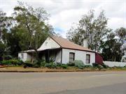
7 Pool St York
York
Avon Arc
Constructed from 1858
| Type | Status | Date | Documents |
|---|---|---|---|
| Heritage List | Adopted | 25 Nov 2019 |
| Type | Status | Date | Documents |
|---|---|---|---|
| RHP - Does not warrant assessment | Current | 27 Jun 2003 |
| Type | Status | Date | Grading/Management | |
|---|---|---|---|---|
| Category | ||||
| Local Heritage Survey | Adopted | 25 Nov 2019 | Grade B | |
Individual Building or Group
| Epoch | General | Specific |
|---|---|---|
| Other Use | RELIGIOUS | Other |
| Present Use | RESIDENTIAL | Single storey residence |
| Original Use | RESIDENTIAL | Single storey residence |
| Type | General | Specific |
|---|---|---|
| Roof | METAL | Corrugated Iron |
| Wall | EARTH | Adobe {Mud Brick} |
| General | Specific |
|---|---|
| SOCIAL & CIVIC ACTIVITIES | Religion |
| DEMOGRAPHIC SETTLEMENT & MOBILITY | Settlements |
This information is provided voluntarily as a public service. The information provided is made available in good faith and is derived from sources believed to be reliable and accurate. However, the information is provided solely on the basis that readers will be responsible for making their own assessment of the matters discussed herein and are advised to verify all relevant representations, statements and information.

Constructed from 1869
Residence, 7 Pool Street is an example of a Victorian Georgian dwelling, with some alterations and additions, on the east side of the Avon River, demonstrating early development of York, and making a contribution to the historical townscape of York. The place is historically and religiously significant for the likely original ownership by Francis Tomney and the Catholic Church services held by the Benedictine Monks.
Single storey masonry residence. Simple hipped roof clad with corrugated iron and has separate front hipped skillion. Original symmetrical front now a balance rhythm of openings due to additions.
It is claimed that prior to the Roman Catholic Church being established in York, the Benedictines from New Norcia used to hold services here. Francis Tomney (1843-1925 York) married Anne (nee Kindelan) in 1869, both Roman Catholics. They had seven children. He was a farmer in York, employed Ticket of Leave men in 1871 and 1880. The 1893 Rate Book lists the owner as Frank Tomney (Farmer).
Integrity: High Authenticity: Moderate
Fair/good
This information is provided voluntarily as a public service. The information provided is made available in good faith and is derived from sources believed to be reliable and accurate. However, the information is provided solely on the basis that readers will be responsible for making their own assessment of the matters discussed herein and are advised to verify all relevant representations, statements and information.

Bounded by Pool, Alfred & Ford Sts & River Avon plus York
Area bounded by: Pool, Alfred & Ford Streets and River Avon (including portions of Avon Terrace, Grey St & Georgiana St). - Part of Central York Heritage Area P26586
York
Avon Arc
| Type | Status | Date | Documents |
|---|---|---|---|
| (no listings) |
| Type | Status | Date | Documents |
|---|---|---|---|
| (no listings) |
| Type | Status | Date | Grading/Management | |
|---|---|---|---|---|
| Category | ||||
| Classified by the National Trust | Classified | |||
Precinct or Streetscape
| Epoch | General | Specific |
|---|---|---|
| Present Use | OTHER | Other |
| Original Use | OTHER | Other |
This information is provided voluntarily as a public service. The information provided is made available in good faith and is derived from sources believed to be reliable and accurate. However, the information is provided solely on the basis that readers will be responsible for making their own assessment of the matters discussed herein and are advised to verify all relevant representations, statements and information.
26586 Central York Heritage Area
This information is provided voluntarily as a public service. The information provided is made available in good faith and is derived from sources believed to be reliable and accurate. However, the information is provided solely on the basis that readers will be responsible for making their own assessment of the matters discussed herein and are advised to verify all relevant representations, statements and information.
Railway St York
Part of Central York Heritage Area P26586
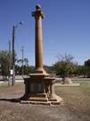
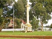
Fallen Soldier’s Memorial
Monument and Park
York War Memorial
York
Avon Arc
Constructed from 1923
| Type | Status | Date | Documents |
|---|---|---|---|
| Heritage List | Adopted | 25 Nov 2019 | |
| State Register | Removed | 01 Jul 2021 | HCWebsite.Listing+ListingDocument |
| Type | Status | Date | Documents |
|---|---|---|---|
| (no listings) |
| Type | Status | Date | Grading/Management | |
|---|---|---|---|---|
| Category | ||||
| Classified by the National Trust | Classified | 01 Apr 1985 | ||
| Register of the National Estate | Nominated | 25 Sep 1985 | ||
| Local Heritage Survey | Adopted | 25 Nov 2019 | Grade A | |
02862 York Town Centre Precinct
| Library Id | Title | Medium | Year Of Publication |
|---|---|---|---|
| 11498 | Conservation management plan: York war memorial. | Heritage Study {Cons'n Plan} | 2011 |
Urban Park
| Epoch | General | Specific |
|---|---|---|
| Other Use | MONUMENT\CEMETERY | Monument |
| Original Use | MONUMENT\CEMETERY | Monument |
| Present Use | OTHER | Other |
| Type | General | Specific |
|---|---|---|
| Other | STONE | Other Stone |
This information is provided voluntarily as a public service. The information provided is made available in good faith and is derived from sources believed to be reliable and accurate. However, the information is provided solely on the basis that readers will be responsible for making their own assessment of the matters discussed herein and are advised to verify all relevant representations, statements and information.
Constructed from 1923
26586 Central York Heritage Area
A memorial which, as part of the social history of York, is also environmentally significant for its contribution to the townscape between the Railway Station and St Patrick's Church – all typical and related Victorian townscape elements. The memorial commemorates the dead from wars earlier.
A stone monument set in a small park adjacent to the Railway Station.
Integrity: Good Authenticity: Good
Fair
| Ref ID No | Ref Name | Ref Source | Ref Date |
|---|---|---|---|
| "Interim Entry – Heritage Council – Register of Heritage Places.". | Heritage Council of WA |
| Owner | Category |
|---|---|
| Dept of Planning and Infrastructure | State Gov't |
| Shire of York | Local Gov't |
This information is provided voluntarily as a public service. The information provided is made available in good faith and is derived from sources believed to be reliable and accurate. However, the information is provided solely on the basis that readers will be responsible for making their own assessment of the matters discussed herein and are advised to verify all relevant representations, statements and information.
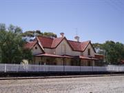
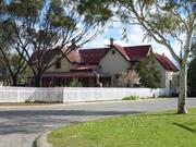
13 Railway St York
Includes platform, quarters, landscape setting inc Orange Tree. Adjacent to P02891 (war memorial) which is registered separately. - Part of Central York Heritage Area P26586
York
Avon Arc
Constructed from 1885 to 1906
| Type | Status | Date | Documents |
|---|---|---|---|
| Heritage List | Adopted | 25 Nov 2019 | |
| Heritage Agreement | YES | 19 Jan 2006 | HCWebsite.Listing+ListingDocument |
| State Register | Registered | 30 Aug 2002 | HCWebsite.Listing+ListingDocument, HCWebsite.Listing+ListingDocument |
| Type | Status | Date | Documents |
|---|---|---|---|
| (no listings) |
| Type | Status | Date | Grading/Management | |
|---|---|---|---|---|
| Category | ||||
| Local Heritage Survey | Adopted | 25 Nov 2019 | Grade A | |
| Register of the National Estate | Registered | 21 Mar 1978 | ||
| Classified by the National Trust | Classified | 25 Sep 1985 | ||
| Statewide Railway Heritage Surve | Completed | 01 Mar 1994 | ||
| Register of the National Estate | Interim | 21 Mar 1978 | ||
02862 York Town Centre Precinct
| Name | Type | Year From | Year To |
|---|---|---|---|
| George Temple Pool | Architect | - | - |
| Norman Hitchcock | Architect | - | - |
| Library Id | Title | Medium | Year Of Publication |
|---|---|---|---|
| 7461 | York sketchbook. | Book | 2003 |
| 4069 | York Railway Station (Fmr) Railway Street York : conservation plan. | Heritage Study {Cons'n Plan} | 1999 |
| 6921 | York Railway Station (fmr), cnr South & Railway Streets, York : conservation plan. | Heritage Study {Cons'n Plan} | 2004 |
Individual Building or Group
| Epoch | General | Specific |
|---|---|---|
| Present Use | Transport\Communications | Rail: Railway Station |
| Original Use | Transport\Communications | Rail: Housing or Quarters |
| Original Use | Transport\Communications | Rail: Railway Station |
| Original Use | RESIDENTIAL | Two storey residence |
| Style |
|---|
| Federation Arts and Crafts |
| Type | General | Specific |
|---|---|---|
| Wall | BRICK | Common Brick |
| Wall | STONE | Local Stone |
| Roof | METAL | Corrugated Iron |
| General | Specific |
|---|---|
| TRANSPORT & COMMUNICATIONS | Rail & light rail transport |
| DEMOGRAPHIC SETTLEMENT & MOBILITY | Settlements |
This information is provided voluntarily as a public service. The information provided is made available in good faith and is derived from sources believed to be reliable and accurate. However, the information is provided solely on the basis that readers will be responsible for making their own assessment of the matters discussed herein and are advised to verify all relevant representations, statements and information.
Constructed from 1906, Constructed from 1885
26586 Central York Heritage Area
A rare example of a Railway Station dating from the 1880s designed to incorporate quarters for the station master within the main station building.
York Railway Station (fmr), a two storey Federation Arts and Crafts style, stone, brick and iron building, comprising a two storey station master’s residence, with living areas at ground floor level and three bedrooms and a bathroom on the first floor at the southern end of the building, and with public areas, including booking and parcels offices and waiting rooms, at the northern end of the building. It is comparatively rare example of a railway station dating from the 1880s designed to incorporate quarters for the station master within the main station building.
The Avon Valley developed in the 1830s as a pastoral region, with the town of York, on the Avon River, established in 1835. A lack of good roads was a major problem for the transport of produce. In 1881, following the opening of the Eastern Railway from Fremantle to Guildford, the railway was extended to Chidlow and onto Northam and York via Spencers Brook. In 1885, part of Avon Locations X and Y on the south side of South Street and owned by John Henry Monger, were subdivided. Location Y was traversed by the railway line, then under construction, and the York station yard was located within the new subdivision. Edward Keane was the contractor for the railway line (and the station buildings). He was involved in the construction of the Midland Railway line, Canning Timber Mill, the Ziz-Zag Railway and the Victoria Reservoir, and held the directorship of Perth's first water supply company and was active (1886-1892) in regional and state politics. York Railway Station had a considerable amount of traffic, given that the major port at that time was at Albany, and all traffic passed through York to the Yilgarn goldfields. The Imperial Hotel was popular being the closest hotel to the railway station. In 1894 York was bypassed when the railway line continued through to Southern Cross. In 1896 the platform was extended 60 metres. In 1899 a spur line opened through to Greenhills. In 1906 extra living space was created for the stationmaster’s quarters. During the 1950s the station was busy due to the wheat yields but there were many delays on the line due to the inadequacy of the goods yard that led to a range of improvements that included a new level crossing and railway sleepers but no works to the buildings or platform. In 1960 the Government contracted with BHP Co Ltd for an iron and steel works in Kwinana contingent on a standard railway between Kalgoorlie and Kwinana via Cannington, transporting iron ore from Koolyanobbing, culminating in the transcontinental standard gauge railway. The rail followed a route through Northam and Toodyay, carrying all the state’s produce, and York subsequently resorted to local traffic on the original track. York Railway Station was rendered almost redundant. The station buildings deteriorated and were even threatened with demolition that led to its Heritage Registration. York Railway Station officially closed to traffic on 18 April 1987; the last stationmaster had moved to Northam in 1986. Westrail leased the station to private entities. In 1989 a museum was established in the former parcels and booking office. It closed in 1999. In the c.2005 the railway station was sold into private ownership.
Integrity: Moderate/High Authenticity: Moderate
Fair
This information is provided voluntarily as a public service. The information provided is made available in good faith and is derived from sources believed to be reliable and accurate. However, the information is provided solely on the basis that readers will be responsible for making their own assessment of the matters discussed herein and are advised to verify all relevant representations, statements and information.
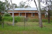
Redmile Rd York
Believed to be No. 6 Redmile Road. Part of Blandstown Heritage Precinct
York
Avon Arc
Constructed from 1860 to 1998
| Type | Status | Date | Documents |
|---|---|---|---|
| Heritage List | Adopted | 25 Nov 2019 | |
| State Register | Registered | 30 Oct 1998 | HCWebsite.Listing+ListingDocument, HCWebsite.Listing+ListingDocument |
| Type | Status | Date | Documents |
|---|---|---|---|
| (no listings) |
| Type | Status | Date | Grading/Management | |
|---|---|---|---|---|
| Category | ||||
| Local Heritage Survey | Adopted | 25 Nov 2019 | Grade A | |
| Register of the National Estate | Registered | 21 Mar 1978 | ||
| Register of the National Estate | Interim | 21 Mar 1978 | ||
| Classified by the National Trust | Classified | 01 May 1985 | ||
02864 Blandstown Heritage Precinct
| Name | Type | Year From | Year To |
|---|---|---|---|
| Bruce Thompson | Architect | - | - |
| Library Id | Title | Medium | Year Of Publication |
|---|---|---|---|
| 9217 | Bridge House - final report. | Conservation works report | 2009 |
| 3619 | Bridge House Conservation Plan | Heritage Study {Cons'n Plan} | 1998 |
| 3931 | Bridge House, York | Heritage Study {Other} | 1999 |
| 4650 | Bridge House : York W.A. : conservation works draft final report : grant allocation 1999/2000. | Heritage Study {Other} | 2000 |
Individual Building or Group
| Epoch | General | Specific |
|---|---|---|
| Original Use | FARMING\PASTORAL | Homestead |
| Present Use | RESIDENTIAL | Two storey residence |
| Style |
|---|
| Victorian Georgian |
| Type | General | Specific |
|---|---|---|
| Wall | STONE | Local Stone |
| Wall | BRICK | Common Brick |
| Roof | METAL | Cast Iron |
| General | Specific |
|---|---|
| DEMOGRAPHIC SETTLEMENT & MOBILITY | Settlements |
| PEOPLE | Early settlers |
This information is provided voluntarily as a public service. The information provided is made available in good faith and is derived from sources believed to be reliable and accurate. However, the information is provided solely on the basis that readers will be responsible for making their own assessment of the matters discussed herein and are advised to verify all relevant representations, statements and information.
Constructed from 1860, Constructed from 1998
02864 Blandstown Heritage Precinct
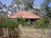
Bridge House is of considerable significance as part of the first inland farm in the Swan River Colony, following settlement of the Avon Valley in 1831. It comprises examples of the Old Colonial Georgian style of architecture and has aesthetic value as a unified group of farm buildings set in the landscape; the place is representative of a phase of agricultural development of the State and the York District and demonstrates close association with Stephen S Parker. Bridge House (1860) is one of the associated historical components that is no longer part of Balladong Farm due to subdivisions in the 1970s, but remains both significant and relevant to the history and interpretation of the place, including Balladong House (1890s), Heal’s Bridge (over Blands Brook) and the site of Parkers Bridge across the Avon River.
Bridge House and grounds is situated on the Avon River at the southern end of the York townsite, in Blandstown. Bridge House, a two-storey brick building with corrugated iron roof and stone cellar, is situated in grounds of 1.62 hectares.
After York was opened for selection in 1830, the first settlers, arrived in 1831 from the Swan River settlement with the task of establishing a Government Farm. Balladong Farm was settled in 1831 by William Heal, later H. Bland after whom Blandstown is named. Stephen Stanley Parker had arrived in the Colony with his parents in 1830. After marrying Elizabeth Sewell in 1944 he relinquished his interest in 'Cold Harbour' to purchase Balladong Farm in 1848. When Parker and his wife moved to Balladong Farm they initially lived in a simple, two-roomed mud brick house that had been built by Bland. During the 1850s, Parker developed the property into a very successful farm. He built stone stables and a granary, and employed many ticket of leave men. In 1858, Parker erected a large steam flour mill and began a flour milling business. In 1860, by which time the Parkers had nine children, Parker had Bridge House built by George Wansbrough, a local builder. Both a builder and a wheelwright, Wansbrough served his apprenticeship in Perth. He returned to York in 1852, where his family had settled 21 years earlier, to assist his brother in cutting the roof of the first Wesley Church. He soon established his own business and in 1860, moved his trade to his newly constructed house in Avon Terrace in the centre of Blandstown (Wansborough House). Parker was very active in public affairs and devoted much of his life to the advancement of the York district. He was a long-time member of the York Agricultural Society and in 1861, he served on the York Board of Education. Governor Weld appointed him a Justice of the Peace in the 1860s and he served on the York Road Board from its inception in 1871 until 1882, including eight years as its Chairman. Parker was also influential in State politics and was a Member of the Legislative Council from July 1876 to 1885. He was also a member of the Aborigines Protection Board and both Stephen and Elizabeth were very active members of the Anglican community in York. In his later years, Stephen was a diocesan trustee of the Church of England in Perth. In 1882, he retired to 325 Adelaide Terrace, Perth to a house similar in design to Bridge House. Stephen and Elizabeth Parker had six daughters and six sons. Four of the sons, including Stephen Stanley Parker jnr., stayed on the land and two 'made their mark on the State's legal history’. Members of the Parker family continued to live at Bridge House until the death of Annie Christina Parker, the widow of John William Parker, in the early 1960s. It has been suggested that Bridge House was used as a hospital around the time of World War One. The partitioning of the upstairs rooms probably occurred during this time. Apart from that brief period, the house has always been used as a residence. Balladong Farm has been subdivided into Balladong Farm, Bridge House and grounds, and Balladong House all on separate land titles. Following the death of Annie Christina Parker, Bridge House and grounds was sold to Hilda May Barrett-Lennard of York on 5 February 1962. The following year, Daisy Ellen Hall Pierce and Pearl Edna Floyed, retired Salvation Army officers, and Olive Irene Haynes purchased the property. They made Bridge House and grounds their home and continued to maintain the house and grounds. Following their deaths, Bridge House and grounds was sold. The place was purchased by Jane and Stephen Hamersley in 1997. They had designs prepared by Bruce Thomspon in 1997 and converted the interior of the house to suit modern living requirements. The principal rooms were left more or less intact. The north and south wings were altered extensively under Thompson's plan.
Integrity: Good Authenticity: Good
Good
| Ref ID No | Ref Name | Ref Source | Ref Date |
|---|---|---|---|
| National Estate Study; "York Historic Survey". |
This information is provided voluntarily as a public service. The information provided is made available in good faith and is derived from sources believed to be reliable and accurate. However, the information is provided solely on the basis that readers will be responsible for making their own assessment of the matters discussed herein and are advised to verify all relevant representations, statements and information.
Redmile Rd York
May refer to Rosemary Cottage, in Blandstown CP as 'cnr of Avon Tce & Redmile Rd'
York
Avon Arc
Constructed from 1895
| Type | Status | Date | Documents |
|---|---|---|---|
| (no listings) |
| Type | Status | Date | Documents |
|---|---|---|---|
| (no listings) |
| Type | Status | Date | Grading/Management | |
|---|---|---|---|---|
| Category | ||||
| Classified by the National Trust | Classified | 01 Apr 1985 | ||
02864 Blandstown Heritage Precinct
Individual Building or Group
| Epoch | General | Specific |
|---|---|---|
| Original Use | RESIDENTIAL | Single storey residence |
| Present Use | RESIDENTIAL | Single storey residence |
This information is provided voluntarily as a public service. The information provided is made available in good faith and is derived from sources believed to be reliable and accurate. However, the information is provided solely on the basis that readers will be responsible for making their own assessment of the matters discussed herein and are advised to verify all relevant representations, statements and information.
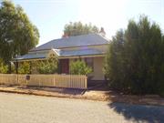
13 Redmile Rd York
Part of Blandstown Heritage Precinct
Clementine Cottage
York
Avon Arc
Constructed from 1890
| Type | Status | Date | Documents |
|---|---|---|---|
| (no listings) |
| Type | Status | Date | Documents |
|---|---|---|---|
| (no listings) |
| Type | Status | Date | Grading/Management | |
|---|---|---|---|---|
| Category | ||||
| Register of the National Estate | Registered | 21 Mar 1978 | ||
| Local Heritage Survey | Adopted | 25 Nov 2019 | Considerable Significance | |
02864 Blandstown Heritage Precinct
Individual Building or Group
| Epoch | General | Specific |
|---|---|---|
| Present Use | RESIDENTIAL | Single storey residence |
| Original Use | RESIDENTIAL | Single storey residence |
| Style |
|---|
| Victorian Georgian |
| Type | General | Specific |
|---|---|---|
| Roof | METAL | Corrugated Iron |
| Wall | BRICK | Pointed Brick |
This information is provided voluntarily as a public service. The information provided is made available in good faith and is derived from sources believed to be reliable and accurate. However, the information is provided solely on the basis that readers will be responsible for making their own assessment of the matters discussed herein and are advised to verify all relevant representations, statements and information.
Constructed from 1860
02864 Blandstown Heritage Precinct
Clementine Cottage, is an historically significant intact c.1860s dwelling on the important early route of Redmile Road to and from Balladong Farm, and across Parker’s Bridge to the Pensioner Guard establishment. It makes a contribution to the historic townscapes of the Blandstown precinct, and of the town of York.
The single storey face brick cottage has a simple hipped roof. A separate skillion roof covers the front veranda and west side veranda supported by square timber posts. The front is symmetrical with central door flanked by single double-hung sash windows.
After York was opened for selection in 1830, the first settlers, arrived in 1831 from the Swan River settlement with the task of establishing a Government Farm. Balladong Farm was settled in 1831 by William Heal, later H. Bland after whom Blandstown is named. Stephen Stanley Parker had arrived in the Colony with his parents in 1830. After marrying Elizabeth Sewell in 1844 he purchased Balladong Farm in 1848. During the 1850s, Parker developed the property into a very successful farm. The “village” now known as Blandstown, the oldest privately settled part of the York town, developed around Balladong Farm due to the influential presence, water supply, and the river crossing. Balladong farm’s original entry was off Redmile Road across Heals Bridge that was close to the Avon River (Parker’s Bridge) crossing to access the pensioner Guard establishment, Redmile House (trading post) and along Redmile Road to Avon Terrace (Great Southern Highway).
Moderate/High
Fair/good
This information is provided voluntarily as a public service. The information provided is made available in good faith and is derived from sources believed to be reliable and accurate. However, the information is provided solely on the basis that readers will be responsible for making their own assessment of the matters discussed herein and are advised to verify all relevant representations, statements and information.
17 Redmile Rd York
Part of Blandstown Heritage Precinct
York
Avon Arc
| Type | Status | Date | Documents |
|---|---|---|---|
| (no listings) |
| Type | Status | Date | Documents |
|---|---|---|---|
| (no listings) |
| Type | Status | Date | Grading/Management | |
|---|---|---|---|---|
| Category | ||||
| Local Heritage Survey | Adopted | 25 Nov 2019 | Little/No Significance | |
Historic site
| Epoch | General | Specific |
|---|---|---|
| Present Use | VACANT\UNUSED | Vacant\Unused |
This information is provided voluntarily as a public service. The information provided is made available in good faith and is derived from sources believed to be reliable and accurate. However, the information is provided solely on the basis that readers will be responsible for making their own assessment of the matters discussed herein and are advised to verify all relevant representations, statements and information.
Constructed from 1860
02864 Blandstown Heritage Precinct
The site of Rosemary Cottage, is historically significant located on the important early route of Redmile Road to and from Balladong Farm, and across Parker’s Bridge to the Pensioner Guard establishment. It represents associations with Kingshead Inn their staff, and a way of life no longer practiced. associated with the staff. It makes a contribution to the historic townscapes of the Blandstown precinct, and of the town of York.
Site.
After York was opened for selection in 1830, the first settlers, arrived in 1831 from the Swan River settlement with the task of establishing a Government Farm. Balladong Farm was settled in 1831 by William Heal, later H. Bland after whom Blandstown is named. Stephen Stanley Parker had arrived in the Colony with his parents in 1830. After marrying Elizabeth Sewell in 1844 he purchased Balladong Farm in 1848. During the 1850s, Parker developed the property into a very successful farm. The “village” now known as Blandstown, the oldest privately settled part of the York town, developed around Balladong Farm due to the influential presence, water supply, and the river crossing. Balladong farm’s original entry was off Redmile Road across Heals Bridge that was close to the Avon River (Parker’s Bridge) crossing to access the pensioner Guard establishment, Redmile House (trading post) and along Redmile Road to Avon Terrace (Great Southern Highway). Rosemary Cottage is recorded as being the accommodation for the “servants’ from the Kingshead Inn.
This information is provided voluntarily as a public service. The information provided is made available in good faith and is derived from sources believed to be reliable and accurate. However, the information is provided solely on the basis that readers will be responsible for making their own assessment of the matters discussed herein and are advised to verify all relevant representations, statements and information.
2-12 Redmile Rd York
Part of Blandstown Heritage Precinct
York
Avon Arc
Constructed from 1853
| Type | Status | Date | Documents |
|---|---|---|---|
| (no listings) |
| Type | Status | Date | Documents |
|---|---|---|---|
| (no listings) |
| Type | Status | Date | Grading/Management | |
|---|---|---|---|---|
| Category | ||||
| Classified by the National Trust | Classified | 25 Sep 1985 | ||
| Register of the National Estate | Registered | 31 Mar 1978 | ||
| Local Heritage Survey | Adopted | 25 Nov 2019 | Exceptional Significance | |
02864 Blandstown Heritage Precinct
Individual Building or Group
| Epoch | General | Specific |
|---|---|---|
| Present Use | RESIDENTIAL | Single storey residence |
| Original Use | RESIDENTIAL | Single storey residence |
| Style |
|---|
| Victorian Georgian |
| Type | General | Specific |
|---|---|---|
| Wall | BRICK | Common Brick |
| Wall | METAL | Corrugated Iron |
This information is provided voluntarily as a public service. The information provided is made available in good faith and is derived from sources believed to be reliable and accurate. However, the information is provided solely on the basis that readers will be responsible for making their own assessment of the matters discussed herein and are advised to verify all relevant representations, statements and information.
Constructed from 1853, Constructed from 1870
02864 Blandstown Heritage Precinct
Redmile House is of considerable historic significance as a rare mostly intact 1853 and 1870 dwellings and the beehive well located at the river crossings (Parker’s Bridge over the Avon River and Heal’s Bridge over Blands Brook) and Balladong Farm juncture of the important early route of Redmile Road to and from Balladong Farm, the Pensioner Guard establishment and linking to Great Southern Highway. Redmile House demonstrates way of life for early settlers, a gallon licence and store that outfitted expeditions and provided general stores, enterprises that are no longer practiced. It is important for its association with early settlers including S (Charles?) Redmile, and later O Sergant, botanist and pharmacist. Redmile House makes a considerable contribution to the historic townscapes of the Blandstown precinct, and the town of York.
The 1853 dwelling is raised above ground level on the south side (street front). It is typically one room deep along the expansive frontage is symmetrical with a central door and two balanced openings each side. The window openings evidence different styles. The brick work is detailed in reverse tone Flemish bond. Part of the front wall has a rendered dado. The hipped roof is clad with corrugated iron and the front veranda has a separate skillion roof hipped at the corner, and supported by square timber posts. The 1870 dwelling is located to the west of the 1853 dwelling and aligned north-south. It is single storey with a hipped roof. It is two rooms deep with a front veranda under the extension of the high-pitched roof. Tall face brick chimneys with a single corbel brick at the top, are evident each side of the dwelling. Windows on the front have been replaced with aluminium framed glazing, and the wall is rendered to dado height. The face brick beehive well is located north of the 1853 dwelling.
After York was opened for selection in 1830, the first settlers, arrived in 1831 from the Swan River settlement with the task of establishing a Government Farm. Balladong Farm was settled in 1831 by William Heal, later H. Bland after whom Blandstown is named. Stephen Stanley Parker had arrived in the Colony with his parents in 1830. After marrying Elizabeth Sewell in 1844 he purchased Balladong Farm in 1848. During the 1850s, Parker developed the property into a very successful farm. He built stone stables and a granary, and employed many ticket of leave men. In 1858, Parker erected a large steam flourmill and began a flour milling business. Balladong farm’s original entry was off Redmile Road across Heals Bridge that was close to the Avon River (Parker’s Bridge) crossing to access the Pensioner Guard establishment, Redmile House (trading post) and along Redmile Road to Avon Terrace (Great Southern Highway). In 1861, Parker's Bridge was constructed over the Avon on Redmile Road at the site of an existing ford. The York convict barracks were located on the eastern side of the bridge. Redmile House, was located on Redmile Road, opposite Bridge House, had a gallon licence and a shop. SS Parker availed Redmile’s premises and stockyards as the departure and return venue for various exploratory expeditions. The most notable being the Henry Maxwell Lefroy Expedition of 1863 and Charles C. Hunt's Expedition of 1864. The house was established by S (Charles?) Redmile. The place was known as Riverview House during the time of Redmile’s occupancy. Obeitho Sargent a Botanist/chemist was an occupant during which time he constructed the distinctive Sargent’s Pharmacy building in Avon Terrace.
Integrity: Moderate Authenticity: High
Fair
| Ref ID No | Ref Name | Ref Source | Ref Date |
|---|---|---|---|
| "Blandstown Conservation Plan". |
This information is provided voluntarily as a public service. The information provided is made available in good faith and is derived from sources believed to be reliable and accurate. However, the information is provided solely on the basis that readers will be responsible for making their own assessment of the matters discussed herein and are advised to verify all relevant representations, statements and information.
22 Redmile Rd York
Part of Blandstown Heritage Precinct
Kenworthy Cottage
York
Avon Arc
Constructed from 1880
| Type | Status | Date | Documents |
|---|---|---|---|
| (no listings) |
| Type | Status | Date | Documents |
|---|---|---|---|
| (no listings) |
| Type | Status | Date | Grading/Management | |
|---|---|---|---|---|
| Category | ||||
| Local Heritage Survey | Adopted | 25 Nov 2019 | Little/No Significance | |
| Register of the National Estate | Registered | 21 Mar 1978 | ||
| Classified by the National Trust | Classified | 01 Apr 1985 | ||
| Register of the National Estate | Nominated | 21 Mar 1978 | ||
02864 Blandstown Heritage Precinct
Individual Building or Group
| Epoch | General | Specific |
|---|---|---|
| Original Use | RESIDENTIAL | Single storey residence |
| Present Use | RESIDENTIAL | Single storey residence |
| Style |
|---|
| Victorian Georgian |
| Type | General | Specific |
|---|---|---|
| Wall | METAL | Corrugated Iron |
| Wall | BRICK | Painted Brick |
This information is provided voluntarily as a public service. The information provided is made available in good faith and is derived from sources believed to be reliable and accurate. However, the information is provided solely on the basis that readers will be responsible for making their own assessment of the matters discussed herein and are advised to verify all relevant representations, statements and information.
Constructed from 1885
02864 Blandstown Heritage Precinct
Residence, 22 Redmile Road is a representative restored c.1870s dwelling with Federation features located on the important early route of Redmile Road to and from Balladong Farm, and across Parker’s Bridge to the Pensioner Guard establishment. It makes a contribution to the historic townscapes of the Blandstown precinct, and of the town of York.
The single storey face brick residence has a simple hipped roof. A separate concave curved-hipped roof covers the front veranda supported by timber posts. The front is symmetrical with central door flanked by single double-hung sash windows. There are rendered chimneys with moulded corbelling each side of the roof ridge, both with clay pots.
After York was opened for selection in 1830, the first settlers, arrived in 1831 from the Swan River settlement with the task of establishing a Government Farm. Balladong Farm was settled in 1831 by William Heal, later H. Bland after whom Blandstown is named. Stephen Stanley Parker had arrived in the Colony with his parents in 1830. After marrying Elizabeth Sewell in 1844 he purchased Balladong Farm in 1848. During the 1850s, Parker developed the property into a very successful farm. The “village” now known as Blandstown, the oldest privately settled part of the York town, developed around Balladong Farm due to the influential presence, water supply, and the river crossing. Balladong farm’s original entry was off Redmile Road across Heals Bridge that was close to the Avon River (Parker’s Bridge) crossing to access the pensioner Guard establishment, Redmile House (trading post) and along Redmile Road to Avon Terrace (Great Southern Highway).
Integrity: Moderate/High Authenticity: Low/Moderate
Good
| Ref ID No | Ref Name | Ref Source | Ref Date |
|---|---|---|---|
| "Blandstown Conservation Plan". |
This information is provided voluntarily as a public service. The information provided is made available in good faith and is derived from sources believed to be reliable and accurate. However, the information is provided solely on the basis that readers will be responsible for making their own assessment of the matters discussed herein and are advised to verify all relevant representations, statements and information.
3 Redmile Rd York
Part of Blandstown Heritage Precinct
York
Avon Arc
| Type | Status | Date | Documents |
|---|---|---|---|
| (no listings) |
| Type | Status | Date | Documents |
|---|---|---|---|
| (no listings) |
| Type | Status | Date | Grading/Management | |
|---|---|---|---|---|
| Category | ||||
| Local Heritage Survey | Adopted | 25 Nov 2019 | Considerable Significance | |
Individual Building or Group
| Epoch | General | Specific |
|---|---|---|
| Present Use | RESIDENTIAL | Single storey residence |
| Style |
|---|
| Federation Bungalow |
| Type | General | Specific |
|---|---|---|
| Wall | BRICK | Painted Brick |
| Roof | METAL | Corrugated Iron |
This information is provided voluntarily as a public service. The information provided is made available in good faith and is derived from sources believed to be reliable and accurate. However, the information is provided solely on the basis that readers will be responsible for making their own assessment of the matters discussed herein and are advised to verify all relevant representations, statements and information.
Constructed from 1890
02864 Blandstown Heritage Precinct
Balladong House (1890s) is one of the associated historical components that is no longer part of Balladong Farm due to subdivisions in the 1970s, but remains both significant and relevant to the history and interpretation of the place, including Bridge House (1860), Heal’s Bridge (over Blands Brook) and the site of Parkers Bridge across the Avon River. Balladong House is of significance for the associations with Balladong Farm and Stephen S Parker and family and it is representative of Federation bungalow; a late development in Blandstown, that makes a considerable contribution to the historic fabric of the precinct and York.
Balladong House is set back from the road set in landscaped gardens with mature palms, it is obscured by trees, facing east to the Avon River, on the southwest side of Heal’s Bridge and Blands Brook, adjacent to Bridge House. The single storey residence has a protruding half-timbered gable frontage with return front veranda with a similar gable detail gable to the north end. The main roof is hipped, and the verandas have a separate skillion roof supported by slender timber posts and decorative brackets. Tall moulded corbelled chimneys are evident.
After York was opened for selection in 1830, the first settlers, arrived in 1831 from the Swan River settlement with the task of establishing a Government Farm. Balladong Farm was settled in 1831 by William Heal, later H. Bland after whom Blandstown is named. Stephen Stanley Parker had arrived in the Colony with his parents in 1830. After marrying Elizabeth Sewell in 1844 he relinquished his interest in 'Cold Harbour' to purchase Balladong Farm in 1848. When Parker and his wife moved to Balladong Farm they initially lived in a simple, two-roomed mud brick house that had been built by Bland. During the 1850s, Parker developed the property into a very successful farm. He built stone stables and a granary, and employed many ticket of leave men. In 1858, Parker erected a large steam flourmill and began a flour milling business. In 1860, by which time the Parkers had nine children, Parker had Bridge House built by George Wansbrough, a local builder. Stephen and Elizabeth Parker had six daughters and six sons. Four of the sons, including Stephen Stanley Parker jnr, stayed on the land and two 'made their mark on the State's legal history.’ In the 1890s, Balladong House was built to the west of Bridge House for a member of the Parker family. Members of the Parker family continued to live at Bridge House until the death of Annie Christina Parker, the widow of John William Parker, in c.1961. Balladong Farm has been subdivided into Balladong Farm, Bridge House and grounds, and Balladong House all on separate land titles in c.1962.
Moderate/High
Fair/good
This information is provided voluntarily as a public service. The information provided is made available in good faith and is derived from sources believed to be reliable and accurate. However, the information is provided solely on the basis that readers will be responsible for making their own assessment of the matters discussed herein and are advised to verify all relevant representations, statements and information.
3 Redmile Rd York
Part of Blandstown Heritage Precinct
York
Avon Arc
| Type | Status | Date | Documents |
|---|---|---|---|
| (no listings) |
| Type | Status | Date | Documents |
|---|---|---|---|
| (no listings) |
| Type | Status | Date | Grading/Management | |
|---|---|---|---|---|
| Category | ||||
| Local Heritage Survey | Adopted | 25 Nov 2019 | Some Significance | |
Other Built Type
This information is provided voluntarily as a public service. The information provided is made available in good faith and is derived from sources believed to be reliable and accurate. However, the information is provided solely on the basis that readers will be responsible for making their own assessment of the matters discussed herein and are advised to verify all relevant representations, statements and information.
Constructed from 1860
02864 Blandstown Heritage Precinct
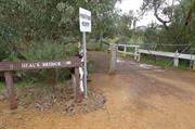
Heal’s Bridge is historically significant being named after the first grantee of the site, and an important access across Blands Brook for Balladong farm and Bridge House in the early days.
An earth and gravel bridge crossing Blands Brook to access Bridge House and Balladong House. Timber railing each side.
After York was opened for selection in 1830, the first settlers, arrived in 1831 from the Swan River settlement with the task of establishing a Government Farm. Balladong Farm was settled in 1831 by William Heal, later H. Bland after whom Blandstown is named. Stephen Stanley Parker had arrived in the Colony with his parents in 1830. After marrying Elizabeth Sewell in 1844 he purchased Balladong Farm in 1848. During the 1850s, Parker developed the property into a very successful farm. He built stone stables and a granary, and employed many ticket of leave men. In 1858, Parker erected a large steam flourmill and began a flour milling business. Heal’s Bridge provided an important crossing over Blands Brook to Redmile House and the Avon River crossing (Parker’s Bridge) as well as the town of York, from Balladong Farm and Bridge House.
Integrity: Moderate Authenticity: Low
Fair
This information is provided voluntarily as a public service. The information provided is made available in good faith and is derived from sources believed to be reliable and accurate. However, the information is provided solely on the basis that readers will be responsible for making their own assessment of the matters discussed herein and are advised to verify all relevant representations, statements and information.
Redmile Rd & Brook St (Avon River Crossing) York
End of Redmile Rd & Brook St (Avon River Crossing) Part of Blandstown Heritage Precinct
York
Avon Arc
| Type | Status | Date | Documents |
|---|---|---|---|
| (no listings) |
| Type | Status | Date | Documents |
|---|---|---|---|
| (no listings) |
| Type | Status | Date | Grading/Management | |
|---|---|---|---|---|
| Category | ||||
| Local Heritage Survey | Adopted | 25 Nov 2019 | Some Significance | |
Historic site
This information is provided voluntarily as a public service. The information provided is made available in good faith and is derived from sources believed to be reliable and accurate. However, the information is provided solely on the basis that readers will be responsible for making their own assessment of the matters discussed herein and are advised to verify all relevant representations, statements and information.
Constructed from 1860
02864 Blandstown Heritage Precinct
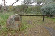
Parker’s Bridge is historically significant being named after Stephen Stanley Parker, who developed Balladong Farm from 1848. Parker’s Bridge provided an important crossing over the Avon River on the site of the c.1831 stone ford. The bridge carried traffic until the 1960s.
Plaque onsite.
After York was opened for selection in 1830, the first settlers, arrived in 1831 from the Swan River settlement with the task of establishing a Government Farm. Balladong Farm was settled in 1831 by William Heal, later H. Bland after whom Blandstown is named. Stephen Stanley Parker had arrived in the Colony with his parents in 1830. After marrying Elizabeth Sewell in 1844 he relinquished his interest in 'Cold Harbour' to purchase Balladong Farm in 1848. When Parker and his wife moved to Balladong Farm they initially lived in a simple, two-roomed mud brick house that had been built by Bland. During the 1850s, Parker developed the property into a very successful farm. He built stone stables and a granary, and employed many ticket of leave men. In 1858, Parker erected a large steam flour mill and began a flour milling business. In 1860, by which time the Parkers had nine children, Parker had Bridge House built by George Wansbrough. Parker’s Bridge provided an important crossing over the Avon River.Parker was very active in public affairs and devoted much of his life to the advancement of the York district. He was a long-time member of the York Agricultural Society and in 1861, he served on the York Board of Education. Governor Weld appointed him a Justice of the Peace in the 1860s and he served on the York Road Board from its inception in 1871 until 1882, including eight years as its Chairman. Parker was also influential in State politics and was a Member of the Legislative Council from July 1876 to 1885. He was also a member of the Aborigines Protection Board and both Stephen and Elizabeth were very active members of the Anglican community in York. In his later years, Stephen was a diocesan trustee of the Church of England in Perth. In 1882, he retired to 325 Adelaide Terrace, Perth to a house similar in design to Bridge House. Stephen and Elizabeth Parker had six daughters and six sons. Four of the sons, including Stephen Stanley Parker jnr, stayed on the land and two ‘made their mark on the State's legal history’. Members of the Parker family continued to live at Bridge House until the death of Annie Christina Parker, the widow of John William Parker, in the early 1960s.
Integrity: Moderate Authenticity: Low
Fair
This information is provided voluntarily as a public service. The information provided is made available in good faith and is derived from sources believed to be reliable and accurate. However, the information is provided solely on the basis that readers will be responsible for making their own assessment of the matters discussed herein and are advised to verify all relevant representations, statements and information.
9 Revett Pl York
Part of Blandstown Heritage Precinct
Burtons Cottage
Lookout for Trains Cottage
York
Avon Arc
Constructed from 1840 to 1988
| Type | Status | Date | Documents |
|---|---|---|---|
| Heritage List | Adopted | 25 Nov 2019 | |
| State Register | Registered | 05 Jan 2001 | HCWebsite.Listing+ListingDocument, HCWebsite.Listing+ListingDocument |
| Type | Status | Date | Documents |
|---|---|---|---|
| (no listings) |
| Type | Status | Date | Grading/Management | |
|---|---|---|---|---|
| Category | ||||
| Local Heritage Survey | Adopted | 25 Nov 2019 | Grade A | |
| Classified by the National Trust | Classified | 05 Mar 1985 | ||
| Register of the National Estate | Permanent | 20 Mar 1978 | ||
02864 Blandstown Heritage Precinct
Individual Building or Group
| Epoch | General | Specific |
|---|---|---|
| Present Use | RESIDENTIAL | Single storey residence |
| Original Use | RESIDENTIAL | Single storey residence |
| Style |
|---|
| Victorian Georgian |
| Type | General | Specific |
|---|---|---|
| Wall | BRICK | Common Brick |
| Roof | METAL | Corrugated Iron |
| Wall | EARTH | Pise {Rammed Earth} |
| General | Specific |
|---|---|
| DEMOGRAPHIC SETTLEMENT & MOBILITY | Settlements |
| PEOPLE | Early settlers |
This information is provided voluntarily as a public service. The information provided is made available in good faith and is derived from sources believed to be reliable and accurate. However, the information is provided solely on the basis that readers will be responsible for making their own assessment of the matters discussed herein and are advised to verify all relevant representations, statements and information.
Constructed from 1840
02864 Blandstown Heritage Precinct
The cottage has heritage significance for the following reasons: The place is a rare, authentic and representative example of the Victorian Georgian style of dwelling constructed by settlers when they first moved onto their land. The place is closely associated with the historical development of the town of York and the Avon Valley and is an integral part of the Blandstown Heritage Precinct. The place has the potential to reveal information on early construction practises within the colony of Western Australia. The place has some associations with R H Bland and S S Parker, both early settlers of the York district who established the area known as Blandstown.
A simple styled building with a central two room ‘core’ constructed from rammed earth, later extensions constructed from soft fired bricks which surround the original two rooms and more recent extensions at the rear of the building constructed from hard fired bricks. The exterior of the cottage has been rendered. The single story structure has a broken pitched, hipped roof covered with corrugated galvanised iron. Three simple brick chimneystacks protrude through the roof on the northern side of the cottage. Native trees and some exotic tree species surround it. The land slopes gently to the east to the eastern property line, which is defined by as Blands Brook.
Bland was one of the first to arrive in the district and was requested by Stirling to establish a Government Stock Station. For his services to the Government, Bland was granted 1,000 acres and later acquired an additional 4,000 acres on the left bank of the Avon River. Bland was appointed Resident Magistrate for York in November 1834. As Bland held this type of position, York’s early development was centred around Bland’s farm at the southern end of present day York. It is possible that the dwelling was built by Bland for his labourers or possibly a overseer. Eliza’s Cottage was identified as part of the Blandstown Heritage Precinct in 1977 in a historical study undertaken by M Feilman and Partners on the town of York.
Integrity: High Authenticity: High
Fair to Moderate
| Ref ID No | Ref Name | Ref Source | Ref Date |
|---|---|---|---|
| M Feilma; "Heritage Study" | Town of York | 1977 |
This information is provided voluntarily as a public service. The information provided is made available in good faith and is derived from sources believed to be reliable and accurate. However, the information is provided solely on the basis that readers will be responsible for making their own assessment of the matters discussed herein and are advised to verify all relevant representations, statements and information.
6 River St York
York
Avon Arc
| Type | Status | Date | Documents |
|---|---|---|---|
| Heritage List | Adopted | 25 Nov 2019 |
| Type | Status | Date | Documents |
|---|---|---|---|
| (no listings) |
| Type | Status | Date | Grading/Management | |
|---|---|---|---|---|
| Category | ||||
| Local Heritage Survey | Adopted | 25 Nov 2019 | Grade B | |
Individual Building or Group
| Epoch | General | Specific |
|---|---|---|
| Present Use | RESIDENTIAL | Single storey residence |
| Style |
|---|
| Victorian Georgian |
| Type | General | Specific |
|---|---|---|
| Wall | BRICK | Face Brick |
This information is provided voluntarily as a public service. The information provided is made available in good faith and is derived from sources believed to be reliable and accurate. However, the information is provided solely on the basis that readers will be responsible for making their own assessment of the matters discussed herein and are advised to verify all relevant representations, statements and information.

Constructed from 1865
Residence, 6 River Street is a good representative example of Victorian Georgian architectural style as a part of the early development immediately north of the Mongers town area, makes a significant contribution to the historical townscape of York.
There is a minimal setback from the front boundary that has a low spaced picket fence and a cottage garden in the setback. The simple hipped roof is separate from the skillion veranda roof supported by square timber posts across the front veranda and the east side. The face brick walls are constructed in Flemish bond with vertical headers to the flat arch windows and door. The symmetrical frontage has single wide double-hung multi-paned window each side of the front door. Face brick corbelled chimneys.
Integrity: High Authenticity: Moderate/High
Good
This information is provided voluntarily as a public service. The information provided is made available in good faith and is derived from sources believed to be reliable and accurate. However, the information is provided solely on the basis that readers will be responsible for making their own assessment of the matters discussed herein and are advised to verify all relevant representations, statements and information.
11 Seabrook St York
Cnr Clifford St
York
Avon Arc
| Type | Status | Date | Documents |
|---|---|---|---|
| Heritage List | Adopted | 25 Nov 2019 |
| Type | Status | Date | Documents |
|---|---|---|---|
| (no listings) |
| Type | Status | Date | Grading/Management | |
|---|---|---|---|---|
| Category | ||||
| Local Heritage Survey | Adopted | 25 Nov 2019 | Grade B | |
Individual Building or Group
| Epoch | General | Specific |
|---|---|---|
| Original Use | EDUCATIONAL | Other |
| Present Use | RESIDENTIAL | Single storey residence |
| Style |
|---|
| Victorian Georgian |
| Type | General | Specific |
|---|---|---|
| Wall | BRICK | Painted Brick |
| Roof | METAL | Corrugated Iron |
This information is provided voluntarily as a public service. The information provided is made available in good faith and is derived from sources believed to be reliable and accurate. However, the information is provided solely on the basis that readers will be responsible for making their own assessment of the matters discussed herein and are advised to verify all relevant representations, statements and information.

Constructed from 1895
York Grammar School (fmr), 11 Seabrook Street is for the associations with the establishment of the York Grammar School by Frank Bennet who was later the first headmaster of Guildford Grammar School. It is a significant example of the Victorian Georgian architectural style, representing one of the early settlements on the east side of the Avon River. It makes a significant contribution the history and historic townscape of York.
The single storey face brick residence has a hipped roof that breaks pitch over the surrounding veranda that is supported by pairs of decorative steel posts. The front is symmetrical with the front door flanked by single double-hung sash windows. The veranda has been enclosed along the side to the front wall. The tall face brick chimneys are corbelled at the top.
An early owner, Mr Henderson, developed a brickworks at the rear of the property. The York Grammar School (closed in 1895) was established by Frank Bennet who later became the first headmaster of Guildford Grammar School.
Integrity: High Authenticity: Moderate/High
Fair/good
This information is provided voluntarily as a public service. The information provided is made available in good faith and is derived from sources believed to be reliable and accurate. However, the information is provided solely on the basis that readers will be responsible for making their own assessment of the matters discussed herein and are advised to verify all relevant representations, statements and information.
11 South St York
Part of Central York Heritage Area P26586
York
Avon Arc
Constructed from 1890
| Type | Status | Date | Documents |
|---|---|---|---|
| (no listings) |
| Type | Status | Date | Documents |
|---|---|---|---|
| (no listings) |
| Type | Status | Date | Grading/Management | |
|---|---|---|---|---|
| Category | ||||
| Register of the National Estate | Nominated | 21 Mar 1978 | ||
| Classified by the National Trust | Classified | 01 Apr 1985 | ||
| Register of the National Estate | Registered | 21 Mar 1978 | ||
| Local Heritage Survey | Adopted | 25 Nov 2019 | Considerable Significance | |
Individual Building or Group
| Epoch | General | Specific |
|---|---|---|
| Original Use | RESIDENTIAL | Single storey residence |
| Present Use | RESIDENTIAL | Single storey residence |
This information is provided voluntarily as a public service. The information provided is made available in good faith and is derived from sources believed to be reliable and accurate. However, the information is provided solely on the basis that readers will be responsible for making their own assessment of the matters discussed herein and are advised to verify all relevant representations, statements and information.

Constructed from 1886
26586 Central York Heritage Area
Residence 11 South Street is significant for associations with William and Henry Eaton and Warwick Marwick, and as a fine example of the late Victorian Georgian period, making a significant contribution to the historic townscape of York.
Single storey random face stone with rendered quoins. The extensive basement is visible on the front façade semi-above ground at front with the ground floor level raised above street level and a stone balustrade (addition) front to the veranda. The roof is hipped with a gable front feature and a separate hipped skillion front veranda roof. The prominent front gable has a rectangular vented detail in the apex, and features a set of two tall double-hung sash windows with rendered surrounds. The recessed front verandah has a reconstructed roof.
Lots 26 and 27 were originally Avon locations X and Y- 100 (acres) DuBois Agett arrived in the Colony in 1830, a member of the London Stock exchange, however his farming and business interests failed and he became a clerk in the Customs Dept, and explored the Avon Valley with RH Bland in 1834. In December 1840 DuBois Agett, a gentleman, acquired this property. In 1884 William Eaton a blacksmith of York purchased the property. It is likely that Eaton constructed the residence during his tenure. In 1904, Edward William Eaton, hotelkeeper, purchased Lot 27 from his father, William Eaton. Three years later, in 1907, he was declared bankrupt on 1 January, and the property was acquired by Warren Marwick, York farmer and Hugh Henry Roche (agent). The remainder of the site had been sold separately. The ownership changed hands several times, with Henry Smith, a draper, acquiring the property in 1927, and his sister/daughter (Spinster, drapers assistant), acquired the property in 1958. In late 1969 Luke Crespi and his wife Estrid purchased the derelict residence and rescued it from bulldozers. Luke Crespi fully restored the residence, and added the front veranda balustrade before on-selling in 1985. Since that time there have been several owners.
Integrity: High Authenticity: Moderate/High
Good
This information is provided voluntarily as a public service. The information provided is made available in good faith and is derived from sources believed to be reliable and accurate. However, the information is provided solely on the basis that readers will be responsible for making their own assessment of the matters discussed herein and are advised to verify all relevant representations, statements and information.
16 South St York
Part of York Town Centre Precinct
York
Avon Arc
| Type | Status | Date | Documents |
|---|---|---|---|
| (no listings) |
| Type | Status | Date | Documents |
|---|---|---|---|
| (no listings) |
| Type | Status | Date | Grading/Management | |
|---|---|---|---|---|
| Category | ||||
| Local Heritage Survey | Adopted | 25 Nov 2019 | Little/No Significance | |
Historic site
| Epoch | General | Specific |
|---|---|---|
| Present Use | VACANT\UNUSED | Vacant\Unused |
| Original Use | COMMERCIAL | Other |
This information is provided voluntarily as a public service. The information provided is made available in good faith and is derived from sources believed to be reliable and accurate. However, the information is provided solely on the basis that readers will be responsible for making their own assessment of the matters discussed herein and are advised to verify all relevant representations, statements and information.
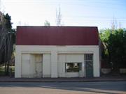
Constructed from 1890
02862 York Town Centre Precinct
The site of the print shop is significant not only as the print shop and associations with the local newspaper, but for the unique construction with an arched brick drain under the building.
Site
An historical photograph shows it was originally a two-storey building with two shop fronts among very few other buildings established at that time, c.1900 the Imperial Hotel, the Catholic group of buildings.
This information is provided voluntarily as a public service. The information provided is made available in good faith and is derived from sources believed to be reliable and accurate. However, the information is provided solely on the basis that readers will be responsible for making their own assessment of the matters discussed herein and are advised to verify all relevant representations, statements and information.
22 South St York
Cnr Howick St - Part of Central York Heritage Area P26586
York
Avon Arc
Constructed from 1887 to 1894
| Type | Status | Date | Documents |
|---|---|---|---|
| Heritage List | Adopted | 25 Nov 2019 | |
| State Register | Registered | 18 May 2004 | HCWebsite.Listing+ListingDocument, HCWebsite.Listing+ListingDocument |
| Type | Status | Date | Documents |
|---|---|---|---|
| (no listings) |
| Type | Status | Date | Grading/Management | |
|---|---|---|---|---|
| Category | ||||
| Local Heritage Survey | Adopted | 25 Nov 2019 | Grade A | |
| Classified by the National Trust | Classified | 05 Mar 1985 | ||
| Register of the National Estate | Permanent | 21 Mar 1978 | ||
| Catholic Church Inventory | Completed | 01 Jul 1998 | ||
| Restrictive Covenant | YES | |||
02862 York Town Centre Precinct
good
| Library Id | Title | Medium | Year Of Publication |
|---|---|---|---|
| 4594 | St Patrick's Church, York : conservation plan. | Heritage Study {Cons'n Plan} | 2000 |
| 6128 | Images CD No. 15 : Kalgoorlie Barracks and St Patricks Church, York. | C D Rom | 2003 |
| 7461 | York sketchbook. | Book | 2003 |
Individual Building or Group
| Epoch | General | Specific |
|---|---|---|
| Original Use | RELIGIOUS | Housing or Quarters |
| Present Use | RELIGIOUS | Housing or Quarters |
| Present Use | RELIGIOUS | Church, Cathedral or Chapel |
| Original Use | RELIGIOUS | Church, Cathedral or Chapel |
| Original Use | RELIGIOUS | Church Hall |
| Style |
|---|
| Victorian Academic Gothic |
| Type | General | Specific |
|---|---|---|
| Wall | STONE | Local Stone |
| Roof | STONE | Slate |
| General | Specific |
|---|---|
| SOCIAL & CIVIC ACTIVITIES | Religion |
This information is provided voluntarily as a public service. The information provided is made available in good faith and is derived from sources believed to be reliable and accurate. However, the information is provided solely on the basis that readers will be responsible for making their own assessment of the matters discussed herein and are advised to verify all relevant representations, statements and information.
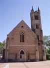
Constructed from 1894, Constructed from 1859
26586 Central York Heritage Area
Cultural heritage significance for the following reasons: 1. The Church Hall and St Patrick’s Church built in the Victorian Gothic style are the only extant examples of this type in the Perth Archdiocese. 2. It forms a significant religious cultural environment especially when the former convent was in operation located directly across the road. 3. It reflects the growth and development of the local parish of York. 4. Makes a significant contribution to the historic streetscape, townscape and character of York in complementing and enhancing the historic fabric of York.
Presbytery stands behind and to the side of the Church. Church Hall stands in the corner of the block in South Street with the railway line behind. The Church dominates the corner of South and Howick Streets and is surrounded by landscaping.
Foundation stone was laid for the original Church in 1887 by Bishop Gibney. Ceiling work was done by a Mr Prunster from Austria. Italian craftsmen added the stone porch in 1950.
Integrity: Good Authenticity: High
Good
| Ref ID No | Ref Name | Ref Source | Ref Date |
|---|---|---|---|
| Heritage Council of WA’s website. | Heritage Council of WA |
| Owner | Category |
|---|---|
| Roman Catholic Bishop of Perth | Church Property |
| Norbertine Fathers Inc of York | Church Property |
This information is provided voluntarily as a public service. The information provided is made available in good faith and is derived from sources believed to be reliable and accurate. However, the information is provided solely on the basis that readers will be responsible for making their own assessment of the matters discussed herein and are advised to verify all relevant representations, statements and information.