Local Government
York
Region
Avon Arc
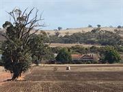
Quairading-York Rd Kauring
Quairading-York Rd, SLK 33.53
MRWA Bridge 0591
York
Avon Arc
| Type | Status | Date | Documents |
|---|---|---|---|
| (no listings) |
| Type | Status | Date | Documents |
|---|---|---|---|
| RHP - Does not warrant assessment | Current | 28 Aug 2015 |
| Type | Status | Date | Grading/Management | |
|---|---|---|---|---|
| Category | ||||
| (no listings) | ||||
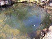
Bridge 0591 is a timber hybrid bridge with a bitumen seal that is 74 years old. There are no archaeological sites located within close proximity of the bridge. The bridge crosses over an unnamed watercourse and is situated along York Merredin Road between the towns of Kauring and East Beverley. The bridge is 14.1m in length, with a deck surface area of 117.59m3. There is no astestos in the structure of the bridge.
Other Built Type
| Epoch | General | Specific |
|---|---|---|
| Present Use | Transport\Communications | Road: Bridge |
| Original Use | Transport\Communications | Road: Bridge |
This information is provided voluntarily as a public service. The information provided is made available in good faith and is derived from sources believed to be reliable and accurate. However, the information is provided solely on the basis that readers will be responsible for making their own assessment of the matters discussed herein and are advised to verify all relevant representations, statements and information.
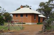
2449 Northam-York Rd Malebelling
Part Lot 8 on Plan 7300
York
Avon Arc
| Type | Status | Date | Documents |
|---|---|---|---|
| Heritage List | Adopted | 25 Nov 2019 |
| Type | Status | Date | Documents |
|---|---|---|---|
| (no listings) |
| Type | Status | Date | Grading/Management | |
|---|---|---|---|---|
| Category | ||||
| Local Heritage Survey | Adopted | 25 Nov 2019 | Grade B | |
Individual Building or Group
| Epoch | General | Specific |
|---|---|---|
| Present Use | RESIDENTIAL | Single storey residence |
| Type | General | Specific |
|---|---|---|
| Wall | BRICK | Face Brick |
| Roof | TILE | Other Tile |
This information is provided voluntarily as a public service. The information provided is made available in good faith and is derived from sources believed to be reliable and accurate. However, the information is provided solely on the basis that readers will be responsible for making their own assessment of the matters discussed herein and are advised to verify all relevant representations, statements and information.
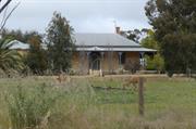
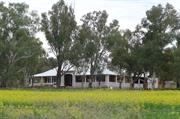
Constructed from 1937
Broadlands is historically significant representing a substantial homestead in the Interwar period of which there are few examples and particularly in the rural homestead setting. York’s farming development associations with the Boyle family. It makes a significant contribution to the historic rural aesthetic of York
The sprawling single storey homestead residence is set back from the road a considerable distance. It evidences an expansive hipped roof with a dominant feature gable frontage in half timbered detail.
Integrity: High Authenticity: Moderate/High
Good
This information is provided voluntarily as a public service. The information provided is made available in good faith and is derived from sources believed to be reliable and accurate. However, the information is provided solely on the basis that readers will be responsible for making their own assessment of the matters discussed herein and are advised to verify all relevant representations, statements and information.
Quairading-York Rd Mount Hardey
Lodges Crossing
MRWA Bridge 0584
York
Avon Arc
| Type | Status | Date | Documents |
|---|---|---|---|
| (no listings) |
| Type | Status | Date | Documents |
|---|---|---|---|
| RHP - Does not warrant assessment | Current | 28 Aug 2015 |
| Type | Status | Date | Grading/Management | |
|---|---|---|---|---|
| Category | ||||
| (no listings) | ||||
Other Built Type
| Epoch | General | Specific |
|---|---|---|
| Present Use | Transport\Communications | Road: Bridge |
| Original Use | Transport\Communications | Road: Bridge |
This information is provided voluntarily as a public service. The information provided is made available in good faith and is derived from sources believed to be reliable and accurate. However, the information is provided solely on the basis that readers will be responsible for making their own assessment of the matters discussed herein and are advised to verify all relevant representations, statements and information.
Quairading-York Rd Mount Hardey
Needling Brook
MRWA Bridge 0582
York
Avon Arc
| Type | Status | Date | Documents |
|---|---|---|---|
| (no listings) |
| Type | Status | Date | Documents |
|---|---|---|---|
| RHP - Does not warrant assessment | Current | 28 Aug 2015 |
| Type | Status | Date | Grading/Management | |
|---|---|---|---|---|
| Category | ||||
| (no listings) | ||||
Bridge 0582 is a timber hybrid bridge with an unsealed surface that is 80 years old. There are no archaeological sites located within close proximity of the bridge. The bridge crosses over an unnamed watercourse and is situated along York Merredin Road between the towns of Mount Hardey and Kauring. The bridge is 14.20m in length with a deck surface are of 124.96m2. There is no asbestos in the structure of the bridge.
Other Built Type
| Epoch | General | Specific |
|---|---|---|
| Present Use | Transport\Communications | Road: Bridge |
| Original Use | Transport\Communications | Road: Bridge |
This information is provided voluntarily as a public service. The information provided is made available in good faith and is derived from sources believed to be reliable and accurate. However, the information is provided solely on the basis that readers will be responsible for making their own assessment of the matters discussed herein and are advised to verify all relevant representations, statements and information.
Quairading-York Rd Mount Hardey
Sims Brook
MRWA Bridge 0583
York
Avon Arc
| Type | Status | Date | Documents |
|---|---|---|---|
| (no listings) |
| Type | Status | Date | Documents |
|---|---|---|---|
| RHP - Does not warrant assessment | Current | 28 Aug 2015 |
| Type | Status | Date | Grading/Management | |
|---|---|---|---|---|
| Category | ||||
| (no listings) | ||||
Bridge 0583 is a timber hybrid bridge with an unsealed surfaced that is 80 years old. There are no archaeological sites located within close proximity of the bridge. The bridge crosses over an unnamed watercourse and is situated along York Merredin Road between the towns of Mount Hardey and Kauring. The bridge is 7.5m in length with a deck surface area of 66m2. There is no asbestos in the structure of the bridge.
Other Built Type
| Epoch | General | Specific |
|---|---|---|
| Original Use | Transport\Communications | Road: Bridge |
| Present Use | Transport\Communications | Road: Bridge |
This information is provided voluntarily as a public service. The information provided is made available in good faith and is derived from sources believed to be reliable and accurate. However, the information is provided solely on the basis that readers will be responsible for making their own assessment of the matters discussed herein and are advised to verify all relevant representations, statements and information.
526 Yarra Road Mount Observation
York
Avon Arc
| Type | Status | Date | Documents |
|---|---|---|---|
| Heritage List | Adopted | 25 Nov 2019 | |
| State Register | Registered | 30 Jun 2020 | HCWebsite.Listing+ListingDocument, HCWebsite.Listing+ListingDocument |
| Type | Status | Date | Documents |
|---|---|---|---|
| (no listings) |
| Type | Status | Date | Grading/Management | |
|---|---|---|---|---|
| Category | ||||
| (no listings) | ||||
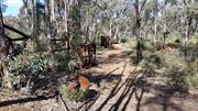
The area ia an abandoned industrial complex comprised of metallic structures (3 Charcoal burning wagons), Charcoal pits, tramlines, bricks, building foundation, hopper bucket and various other items.
Historic Site
| Epoch | General | Specific |
|---|---|---|
| Present Use | FORESTRY | Other |
| Original Use | INDUSTRIAL\MANUFACTURING | Other |
This information is provided voluntarily as a public service. The information provided is made available in good faith and is derived from sources believed to be reliable and accurate. However, the information is provided solely on the basis that readers will be responsible for making their own assessment of the matters discussed herein and are advised to verify all relevant representations, statements and information.
This information is provided voluntarily as a public service. The information provided is made available in good faith and is derived from sources believed to be reliable and accurate. However, the information is provided solely on the basis that readers will be responsible for making their own assessment of the matters discussed herein and are advised to verify all relevant representations, statements and information.
45 Burges Siding Rd Quellington
York
Avon Arc
Constructed from 1853, Constructed from 1915
| Type | Status | Date | Documents |
|---|---|---|---|
| Heritage List | Adopted | 25 Nov 2019 |
| Type | Status | Date | Documents |
|---|---|---|---|
| RHP - To be assessed | Current | 12 Dec 2003 |
| Type | Status | Date | Grading/Management | |
|---|---|---|---|---|
| Category | ||||
| Local Heritage Survey | Adopted | 25 Nov 2019 | Grade B | |
The place is a remnant of an early settlement in the York district and is one of the oldest homestead ruins in the area.
The place is associated with the development of the agricultural industry in the York region and the consolidation of that industry in the early part of the 20th century.
The second homestead is a fine example of a rural residence constructed in the Federation Queen Anne style.
The original homestead is a single storey, former residence constructed in the Victorian Georgian style in a symmetrical ‘U’ shape. The walls are exposed brick, possibly of local construction. The roof is steeply pitched and has been re-covered at some stage with galvanised corrugated iron. The windows and doors have been removed and some of the roof sheeting has fallen. The second homestead is a single storey residence constructed in the Federation Queen Anne style. The walls are tuckpointed red brick with a 30cm rendered band encircling the house approximately 1m up the wall. The windows are double-hung sash windows. The residence has recently been re-roofed with GCI. 3 tall chimneys have terracotta pots, and the gables have a half-timbered effect. The verandah, which encloses the house on all sides, appears to have recently been replaced.
As river frontages were taken up along the Swan River, and the population of the colony continued to increase, the reality of food shortages in the colony induced Governor Stirling to commission 21-year-old Ensign Dale to explore east of the Darling Range in search of arable land. Following Dale’s expeditions in the 1830s, and a few other expeditions which confirmed Dale’s reports, land was opened in the Avon District. Although James Henty was the first to apply for a land grant in this area, his original selection was refused as it included 2 square miles at the foot of Mt Bakewell, which Stirling reserved as a town site in November 1830. It was the following September before the settler arrived in York. Within a month almost a quarter of a million acres had been taken up in the York district although much of this land was claimed by those who had land entitlements but no real intention of immediate settlement. By July 1832, there were 18 settlers and four soldiers based in York, and within 2 years half of the colony’s sheep were grazing in the district. By 1836 the district had a population of 65, including members of many well-known pioneer families in Western Australia. The period of settlement between 1832 and 1839 saw land being allocated in extensive grants. The original occupiers were to be joined later by other settlers who were also responsible for substantial growth in the York district. The 45ha property at Tipperary was originally purchased by an Irish doctor for his 3 sons in 1837. The construction of the second homestead occurred at a time when the York area was prospering from the consolidation of the farming industry due to the construction of the railway and the boom resulting from the goldrushes. In 1980 Peter Briggs purchased the property. He sold it to John & Karen Hay who were responsible for the restoration work on the York Hotel. The property was sold again in 1999.
High
Old Residence- Poor Second Residence- Good
| Library Id | Title | Medium | Year Of Publication |
|---|---|---|---|
| 5921 | Off-shears : the story of shearing sheds in Western Australia. | Book | 2002 |
Individual Building or Group
| Epoch | General | Specific |
|---|---|---|
| Original Use | FARMING\PASTORAL | Homestead |
| Present Use | FARMING\PASTORAL | Homestead |
| Style |
|---|
| Victorian Georgian |
| Federation Queen Anne |
| Type | General | Specific |
|---|---|---|
| Wall | BRICK | Pointed Brick |
| Wall | BRICK | Handmade Brick |
| Roof | METAL | Corrugated Iron |
| General | Specific |
|---|---|
| PEOPLE | Early settlers |
| OCCUPATIONS | Grazing, pastoralism & dairying |
This information is provided voluntarily as a public service. The information provided is made available in good faith and is derived from sources believed to be reliable and accurate. However, the information is provided solely on the basis that readers will be responsible for making their own assessment of the matters discussed herein and are advised to verify all relevant representations, statements and information.
Constructed from 1853
Tipperary Farm is historically significant for one of the earliest farm settlements in York and the associations with Richard Goldsmith Burges and his son William Goldsmith Burges both significant identities integral to the development of York. The remaining fabric from the 1830s is rare.
Located on the east bank of the Avon River, the farm buildings comprise a group of brick buildings that were in ruin over a decade ago. Re-roofed in recent times.
Richard Goldsmith Burges was one of three brothers who established Tipperary in the 1830s. One of the brothers, William, had no heirs. Richard Goldsmith Burges was the Resident Magistrate in York in 1843. William Goldsmith Burges inherited Tipperary from his father Richard Goldsmith Burges. He married Mary Scholl in 1912. He was a farmer and stud breeder winning the Governor’s Cup at the Royal Show 3 consecutive shows. He was on the Council of the Royal Agricultural Society for 50 years and received an OBE for his services. He was on the York Road Board for 33 years, 20 years as the Chairman.
Integrity: High Authenticity: Moderate/High
Good
This information is provided voluntarily as a public service. The information provided is made available in good faith and is derived from sources believed to be reliable and accurate. However, the information is provided solely on the basis that readers will be responsible for making their own assessment of the matters discussed herein and are advised to verify all relevant representations, statements and information.
45 Burges Siding Rd Quellington
Lot 10 on Diagram 61277
York
Avon Arc
| Type | Status | Date | Documents |
|---|---|---|---|
| Heritage List | Adopted | 25 Nov 2019 |
| Type | Status | Date | Documents |
|---|---|---|---|
| (no listings) |
| Type | Status | Date | Grading/Management | |
|---|---|---|---|---|
| Category | ||||
| (no listings) | ||||
Individual Building or Group
| Epoch | General | Specific |
|---|---|---|
| Present Use | RESIDENTIAL | Single storey residence |
| Type | General | Specific |
|---|---|---|
| Wall | BRICK | Face Brick |
This information is provided voluntarily as a public service. The information provided is made available in good faith and is derived from sources believed to be reliable and accurate. However, the information is provided solely on the basis that readers will be responsible for making their own assessment of the matters discussed herein and are advised to verify all relevant representations, statements and information.
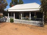
Constructed from 1915
Tipperary Homestead is historically significant in representing the next generation of development of Tipperary Farm and the associations with Richard Goldsmith Burges’ son William Goldsmith Burges a significant identity integral to the development of York. The early interwar homestead is a fine example of the period and contributes to the rural setting on the east bank of the Avon river.
The sprawling homestead is set in the rural landscape. The hipped roof is complex with feature gables. It is clad with Marseille clay roof tiles with exposed rafters. The structure comprises face brick dado walls with render above. The face brick chimneys are tall and square with little detailing.
Richard Goldsmitth Burges was one of three brothers who established Tipperary in the 1830s. One of the brothers, William, had no heirs. William Goldsmith Burges inherited Tipperary from his father Richard Goldsmith Burges. He married Mary Scholl in 1912. He was a farmer and stud breeder winning the Governor’s Cup at the Royal Show 3 consecutive shows. He was on the Council of the Royal Agricultural Society for 50 years and received and OBE for his services. He was on the York Road Board for 33 years, 20 years as the Chairman.
Integrity: High Authenticity: Moderate/High
Good
This information is provided voluntarily as a public service. The information provided is made available in good faith and is derived from sources believed to be reliable and accurate. However, the information is provided solely on the basis that readers will be responsible for making their own assessment of the matters discussed herein and are advised to verify all relevant representations, statements and information.
835 Sees Rd Quellington
Lot 1322 on Plan 247031
York
Avon Arc
| Type | Status | Date | Documents |
|---|---|---|---|
| Heritage List | Adopted | 25 Nov 2019 |
| Type | Status | Date | Documents |
|---|---|---|---|
| (no listings) |
| Type | Status | Date | Grading/Management | |
|---|---|---|---|---|
| Category | ||||
| Local Heritage Survey | Adopted | 25 Nov 2019 | Grade B | |
Individual Building or Group
| Epoch | General | Specific |
|---|---|---|
| Present Use | RESIDENTIAL | Single storey residence |
| Style |
|---|
| Federation Bungalow |
| Type | General | Specific |
|---|---|---|
| Wall | BRICK | Face Brick |
This information is provided voluntarily as a public service. The information provided is made available in good faith and is derived from sources believed to be reliable and accurate. However, the information is provided solely on the basis that readers will be responsible for making their own assessment of the matters discussed herein and are advised to verify all relevant representations, statements and information.
Constructed from 1900
Quellington School House (fmr) is of considerable historical significance in association with Quellington School. It demonstrates close associations with the Gentle family and the early provision of schools and a way of life for school teachers in the country that is no longer practiced.
The single storey masonry building has a hipped roof with a separate hipped roof to the perimeter veranda. There is a small gable central on the veranda roof of the symmetrical frontage that has a set of concrete stairs to the veranda.
The first Queliington School was built by Mr Samuel Gentle for his 5 children. In 1884, Provisional School status was achieved with 18 students, although it closed in 1885. It opened again in 1889. In 1895, a new school was constructed on Mr Gentle’s land. In 1920 the school was closed and re-opened with the teacher sharing Quellington and Malebelling schools for a short time. In September 1930, the school re-opened. By 1943 there were only 6 children enrolled and it closed in 1944.
Integrity: High Authenticity: Moderate/High
Good
This information is provided voluntarily as a public service. The information provided is made available in good faith and is derived from sources believed to be reliable and accurate. However, the information is provided solely on the basis that readers will be responsible for making their own assessment of the matters discussed herein and are advised to verify all relevant representations, statements and information.
844 Sees Rd Quellington
Lot 10488 on Plan 250276
York
Avon Arc
| Type | Status | Date | Documents |
|---|---|---|---|
| Heritage List | Adopted | 25 Nov 2019 |
| Type | Status | Date | Documents |
|---|---|---|---|
| (no listings) |
| Type | Status | Date | Grading/Management | |
|---|---|---|---|---|
| Category | ||||
| Local Heritage Survey | Adopted | 25 Nov 2019 | Grade B | |
Individual Building or Group
This information is provided voluntarily as a public service. The information provided is made available in good faith and is derived from sources believed to be reliable and accurate. However, the information is provided solely on the basis that readers will be responsible for making their own assessment of the matters discussed herein and are advised to verify all relevant representations, statements and information.
Quellington School is of considerable historical, social and aesthetic importance as one of the very few remaining schools representing the educational development in the York area. It demonstrates close associations with Samuel Gentle and family and the early provision of schools. It is a fine example of an isolated rural school in Federation bungalow architectural style. The School closed in 1944 with the centralisation policy and students were transported to York. It was a way of life, of education that is no longer practiced and makes a significant contribution to the historic aesthetic of the York district countryside.
The single storey building is detailed in colonial bond face brickwork on a rendered plinth. The corrugated iron roof is hipped with gablets, and the veranda has a low skillion extension of the main roof. The veranda entry is detailed with an arched valance of vertical spaced timbers. The face brick chimney is deeply corbelled.
The first Queliington School was built by Mr Samuel Gentle for his 5 children. Others joined the “Gentle School” at a payment towards the teacher’s salary. In 1884 Provisional School status was achieved with 18 students, although it closed in 1885. It opened again in 1889. In 1895, a new school was constructed on Mr Gentle’s land, by Thorn, Bower & Stewart building contractors. In 1920 the school was closed due to influenza epidemic causing low attendance. At that time, the issue of country schools was raised in parliament and Quellington parents were given 3 options: take their children to York School, employ a teacher at their own cost or join correspondence classes. The school remained opened with the teacher sharing Quellington and Malebelling schools. Although that was short term and the school closed in May 1920. In September 1930, the school re-opened. By 1943 there were only 6 children enrolled and it closed in 1944, and the furniture and children transported to York. The school bus driver lived in the school building until 1952, and members of the Gentle family lived there for a short time, and in 1954 Mark Gentle purchased the building from the Education Department, on the land that was already owned by the family. The school building functions as a Bed and Breakfast accommodation facility.
Integrity: High Authenticity: Moderate/High
Good
This information is provided voluntarily as a public service. The information provided is made available in good faith and is derived from sources believed to be reliable and accurate. However, the information is provided solely on the basis that readers will be responsible for making their own assessment of the matters discussed herein and are advised to verify all relevant representations, statements and information.
Great Southern Hwy St Ronans
77 km from Perth on north side of Old York Rd
St Ronan's Well and Conservation Area
York
Avon Arc
Constructed from 1832
| Type | Status | Date | Documents |
|---|---|---|---|
| Heritage List | Adopted | 25 Nov 2019 | |
| State Register | Registered | 24 Jun 2011 | HCWebsite.Listing+ListingDocument, HCWebsite.Listing+ListingDocument |
| Type | Status | Date | Documents |
|---|---|---|---|
| (no listings) |
| Type | Status | Date | Grading/Management | |
|---|---|---|---|---|
| Category | ||||
| Local Heritage Survey | Adopted | 25 Nov 2019 | Grade A | |
| Classified by the National Trust | Classified | 04 Feb 1980 | ||
| Register of the National Estate | Permanent | 28 Sep 1982 | ||
04429 St Ronan's Well Reserve
Historic site
| Epoch | General | Specific |
|---|---|---|
| Original Use | GOVERNMENTAL | Reservoir or Dam |
| Present Use | OTHER | Other |
| Type | General | Specific |
|---|---|---|
| Wall | BRICK | Handmade Brick |
| General | Specific |
|---|---|
| TRANSPORT & COMMUNICATIONS | Road transport |
| PEOPLE | Early settlers |
| DEMOGRAPHIC SETTLEMENT & MOBILITY | Settlements |
| OCCUPATIONS | Grazing, pastoralism & dairying |
| DEMOGRAPHIC SETTLEMENT & MOBILITY | Workers {incl. Aboriginal, convict} |
This information is provided voluntarily as a public service. The information provided is made available in good faith and is derived from sources believed to be reliable and accurate. However, the information is provided solely on the basis that readers will be responsible for making their own assessment of the matters discussed herein and are advised to verify all relevant representations, statements and information.
Historic
Set in amongst a reserve of approximately 118ha.
Good
Poor
This information is provided voluntarily as a public service. The information provided is made available in good faith and is derived from sources believed to be reliable and accurate. However, the information is provided solely on the basis that readers will be responsible for making their own assessment of the matters discussed herein and are advised to verify all relevant representations, statements and information.
314 Talbot Hall Rd Talbot
Reserve 12190
York
Avon Arc
| Type | Status | Date | Documents |
|---|---|---|---|
| Heritage List | Adopted | 25 Nov 2019 |
| Type | Status | Date | Documents |
|---|---|---|---|
| (no listings) |
| Type | Status | Date | Grading/Management | |
|---|---|---|---|---|
| Category | ||||
| Local Heritage Survey | Adopted | 25 Nov 2019 | Grade B | |
Individual Building or Group
| Epoch | General | Specific |
|---|---|---|
| Present Use | SOCIAL\RECREATIONAL | Other Community Hall\Centre |
| Original Use | EDUCATIONAL | Combined School |
| Type | General | Specific |
|---|---|---|
| Wall | METAL | Corrugated Iron |
| Roof | METAL | Corrugated Iron |
This information is provided voluntarily as a public service. The information provided is made available in good faith and is derived from sources believed to be reliable and accurate. However, the information is provided solely on the basis that readers will be responsible for making their own assessment of the matters discussed herein and are advised to verify all relevant representations, statements and information.
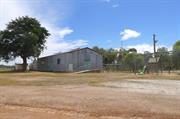
Constructed from 1911 to 1944, Constructed from 1954
Talbot Hall and the site of the Talbot Brook School is are historically and socially significant as the centre of the local community for meetings, socialising and social and education activities of the local community since 1911. The sense of place for generations of the community and the continued focus of Talbot Hall represents the quintessential country spirit.
The hall is an expansive corrugated iron structure with a low-pitched gable roof. There is a semidetached gable shed at right angles at the rear, with a skillion enclosure along the rear of the overall structure.
In 1906 PJ McDougall requested a school at Talbot Brook. By 1908 there was no school mostly due to the Reverend Dunn who thought that Qualen School was appropriate. The Talbot Brook Progress Association took up the issue. Due to fluctuating numbers of children, the unlined corrugated iron clad school provided by the Progress Association was not opened until 1911. The school was under constant threat of closure, which happened twice in 1921, once due to inadequate teacher accommodation (a small lean-to at the end of the school). An extension was built. Periods of closure happened again in 1925 and 1928. In 1936 a new building was requested. In 1944 the school was closed due to low attendance and students transferred to York. At a meeting of the Talbot Hall committee in March 1954 it was to investigate and get a quote for a steel framed hall building. The secretary of the committee was T Duperouzel. Their specifications included: steel framed fabrication measuring 60 feet x 30 feet x 11’6” high, double doors, and 3 steel framed windows each side with louvres. The hall was opened in 1954.
Integrity: High Authenticity: Moderate/High
Good
This information is provided voluntarily as a public service. The information provided is made available in good faith and is derived from sources believed to be reliable and accurate. However, the information is provided solely on the basis that readers will be responsible for making their own assessment of the matters discussed herein and are advised to verify all relevant representations, statements and information.
Northam Rd Tipperary
St Pauls
York
Avon Arc
Constructed from 1892
| Type | Status | Date | Documents |
|---|---|---|---|
| Heritage List | Adopted | 25 Nov 2019 |
| Type | Status | Date | Documents |
|---|---|---|---|
| RHP - Does not warrant assessment | Current | 12 Dec 2003 |
| Type | Status | Date | Grading/Management | |
|---|---|---|---|---|
| Category | ||||
| Local Heritage Survey | Adopted | 25 Nov 2019 | Grade B | |
Individual Building or Group
| Epoch | General | Specific |
|---|---|---|
| Present Use | RESIDENTIAL | Single storey residence |
| Original Use | RELIGIOUS | Church, Cathedral or Chapel |
| Type | General | Specific |
|---|---|---|
| Wall | BRICK | Common Brick |
| Roof | METAL | Corrugated Iron |
| General | Specific |
|---|---|
| SOCIAL & CIVIC ACTIVITIES | Religion |
This information is provided voluntarily as a public service. The information provided is made available in good faith and is derived from sources believed to be reliable and accurate. However, the information is provided solely on the basis that readers will be responsible for making their own assessment of the matters discussed herein and are advised to verify all relevant representations, statements and information.
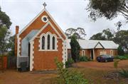
Constructed from 1892
St Paul’s Church represents a place of worship for a small country community, demonstrating a way of life that no longer practiced and the development of the place into an event venue that together with the church worship and events, engenders a sense of place.
The church is located in the midst of a group of various buildings that comprise a residence, former art gallery, residence in the church building, and the gardens are landscaped for events. The steeply pitched gable roof of the original church adjoins a long-form pavilion roofed addition to the north. The original section is face brick with rendered quoins and moulded edgings. A protruding section replicating the form at a lower scale features a triple gothic arched windows with rendered edgings.
Integrity: Low Authenticity: Low/Moderate
Good
This information is provided voluntarily as a public service. The information provided is made available in good faith and is derived from sources believed to be reliable and accurate. However, the information is provided solely on the basis that readers will be responsible for making their own assessment of the matters discussed herein and are advised to verify all relevant representations, statements and information.
Northam Rd Tipperary
York
Avon Arc
Constructed from 1874
| Type | Status | Date | Documents |
|---|---|---|---|
| (no listings) |
| Type | Status | Date | Documents |
|---|---|---|---|
| (no listings) |
| Type | Status | Date | Grading/Management | |
|---|---|---|---|---|
| Category | ||||
| Municipal Inventory | Adopted | 31 Dec 1995 | Category 4 | |
Individual Building or Group
| Epoch | General | Specific |
|---|---|---|
| Present Use | VACANT\UNUSED | Vacant\Unused |
| Original Use | EDUCATIONAL | Combined School |
This information is provided voluntarily as a public service. The information provided is made available in good faith and is derived from sources believed to be reliable and accurate. However, the information is provided solely on the basis that readers will be responsible for making their own assessment of the matters discussed herein and are advised to verify all relevant representations, statements and information.
Constructed from 1874
Integrity: Ruins Authenticity: Ruins
Ruins
| Ref ID No | Ref Name | Ref Source | Ref Date |
|---|---|---|---|
| Heritage Council’s Website | Heritage Council of WA |
This information is provided voluntarily as a public service. The information provided is made available in good faith and is derived from sources believed to be reliable and accurate. However, the information is provided solely on the basis that readers will be responsible for making their own assessment of the matters discussed herein and are advised to verify all relevant representations, statements and information.
Spencers Brook - York rd Wilberforce
York
Avon Arc
| Type | Status | Date | Documents |
|---|---|---|---|
| (no listings) |
| Type | Status | Date | Documents |
|---|---|---|---|
| (no listings) |
| Type | Status | Date | Grading/Management | |
|---|---|---|---|---|
| Category | ||||
| Local Heritage Survey | Adopted | 25 Nov 2019 | Grade C | |
Individual Building or Group
This information is provided voluntarily as a public service. The information provided is made available in good faith and is derived from sources believed to be reliable and accurate. However, the information is provided solely on the basis that readers will be responsible for making their own assessment of the matters discussed herein and are advised to verify all relevant representations, statements and information.
Constructed from 1885
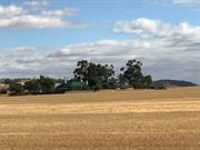
Hamersley Siding is associated with the railway extension from York through Spencer’s Brook junction to Perth and Northam. Hamersley Siding was one of several sidings between York and Spencer’s Brook providing access to local farmers for the sending and receiving of their goods and supplies. Hamersley Siding represents historic associations with Hamersley family.
No evidence onsite.
The Avon Valley developed in the 1830s as a pastoral region, with the town of York, on the Avon River, established in 1835. A lack of good roads was a major problem for the transport of produce. In 1881, following the opening of the Eastern Railway from Fremantle to Guildford, the railway was extended to Chidlow and onto Northam and York via Spencers Brook. In 1885, part of Avon Locations X and Y on the south side of South Street and owned by John Henry Monger, were subdivided. Location Y was traversed by the railway line, then under construction, and the York station was located in the new subdivision. Edward Keane was the contractor for the railway line. In 1960 the Government contracted with BHP Co Ltd for an iron and steel works in Kwinana contingent on a standard railway between Kalgoorlie and Kwinana via Cannington, transporting iron ore from Koolyanobbing, culminating in the transcontinental standard gauge railway. The rail followed a route through Northam and Toodyay, carrying all the state’s produce, and York subsequently resorted to local traffic on the original track. York Railway Station was rendered almost redundant. York Railway Station officially closed to traffic on18 April 1987.
This information is provided voluntarily as a public service. The information provided is made available in good faith and is derived from sources believed to be reliable and accurate. However, the information is provided solely on the basis that readers will be responsible for making their own assessment of the matters discussed herein and are advised to verify all relevant representations, statements and information.
2500 Spencers Brook - York Rd Wilberforce
Lot 71 on Plan 50908
York
Avon Arc
| Type | Status | Date | Documents |
|---|---|---|---|
| (no listings) |
| Type | Status | Date | Documents |
|---|---|---|---|
| (no listings) |
| Type | Status | Date | Grading/Management | |
|---|---|---|---|---|
| Category | ||||
| Local Heritage Survey | Adopted | 25 Nov 2019 | Grade B | |
Individual Building or Group
| Epoch | General | Specific |
|---|---|---|
| Present Use | RESIDENTIAL | Single storey residence |
| Type | General | Specific |
|---|---|---|
| Wall | BRICK | Face Brick |
This information is provided voluntarily as a public service. The information provided is made available in good faith and is derived from sources believed to be reliable and accurate. However, the information is provided solely on the basis that readers will be responsible for making their own assessment of the matters discussed herein and are advised to verify all relevant representations, statements and information.
Constructed from 1900
Hamersley Homestead is aesthetically and historically significant as a fine example of Federation Bungalow architecture in the rural location and for the associations with the Hamersley family.
The expansive residence is located in a rural setting some distance form the road. The main roof is hipped and breaks pitch over the surrounding verandas, enclosed across the rear. The residence is elevated and the veranda has a vertical spaced timber balustrade around the entirety with timber posts, detailed in pairs about the corners. The central front entry the veranda makes a statement with vertical spaced timbered panels each side of an arched opening. There seems to be a gable detail on the southeast side. The front wall seems to be symmetrical with bay windows each side of the central entry. The bays have sets of casement windows with fanlights above. Arched details are evident. Face brick chimney has double clay pots.
Edward Hamersley (1835-1921) arrived in the colony with his parents in 1837. He returned in 1850 and after 30 years in the Swan valley, he came to York in 1880. In 1874, he inherited Wilberforce and Woodside properties in York area from his father Edward snr who had purchased them in 1837 when he arrived in the colony. Edward snr founded a high grade of sheep by importing several high-class merino rams, also high-grade milking cattle. He left 12,000 acres of properties to 7 sons; Edward, Charles, Percy, Andrew (d.) Samuel. (and ??) The 5th son is at Rivoli at Hamersley Siding- he married Laura Sharp of Woolleen. Edward jnr served on the Legislative Council representing York from 1880 to 1894.
High
Good
This information is provided voluntarily as a public service. The information provided is made available in good faith and is derived from sources believed to be reliable and accurate. However, the information is provided solely on the basis that readers will be responsible for making their own assessment of the matters discussed herein and are advised to verify all relevant representations, statements and information.
2946 Spencers Brook - York Rd Wilberforce
Lot 30 on Plan 29266
York
Avon Arc
| Type | Status | Date | Documents |
|---|---|---|---|
| Heritage List | Adopted | 25 Nov 2019 |
| Type | Status | Date | Documents |
|---|---|---|---|
| (no listings) |
| Type | Status | Date | Grading/Management | |
|---|---|---|---|---|
| Category | ||||
| Local Heritage Survey | Adopted | 25 Nov 2019 | Grade B | |
Individual Building or Group
| Epoch | General | Specific |
|---|---|---|
| Present Use | RESIDENTIAL | Single storey residence |
| Style |
|---|
| Federation Bungalow |
This information is provided voluntarily as a public service. The information provided is made available in good faith and is derived from sources believed to be reliable and accurate. However, the information is provided solely on the basis that readers will be responsible for making their own assessment of the matters discussed herein and are advised to verify all relevant representations, statements and information.
Constructed from 1900
Hamersley Homestead is aesthetically and historically significant as an example of Federation Bungalow architecture in the rural location and for the associations with the Hamersley family.
Homestead set within a delineated home garden in the midst of the wheat crop. The expansive high-pitched roof is predominantly hipped with a gable ’front’ feature in half-timbered detail. There is a separate veranda roof to verandas on at least 2 sides. 4 tall brick chimneys with corbelled detailing dominate the roof line.
Edward Hamersley (1835-1921) arrived in the colony with his parents in 1837. He returned in 1850 and after 30 years in the Swan valley, he came to York in 1880. In 1874, he inherited Wilberforce and Woodside properties in York area from his father Edward snr who had purchased them in 1837 when he arrived in the colony. Edward snr founded a high grade of sheep by importing several high-class merino rams, also high-grade milking cattle. He left 12,000 acres of properties to 7 sons; Edward, Charles, Percy, Andrew (d.) Samuel. (and ??) The 5th son is at Rivoli at Hamersley Siding- he married Laura Sharp of Woolleen. Edward jnr served on the Legislative Council representing York from 1880 to 1894. Historical notes may apply to Place 285.
Integrity: High Authenticity: Moderate/High
Good
This information is provided voluntarily as a public service. The information provided is made available in good faith and is derived from sources believed to be reliable and accurate. However, the information is provided solely on the basis that readers will be responsible for making their own assessment of the matters discussed herein and are advised to verify all relevant representations, statements and information.
York
York
Avon Arc
| Type | Status | Date | Documents |
|---|---|---|---|
| (no listings) |
| Type | Status | Date | Documents |
|---|---|---|---|
| (no listings) |
| Type | Status | Date | Grading/Management | |
|---|---|---|---|---|
| Category | ||||
| Register of the National Estate | Indicative Place | |||
| Register of the National Estate | Nominated | 13 Mar 1992 | ||
| Classified by the National Trust | Classified {Lscpe} | 03 Dec 1984 | ||
Landscape
| Epoch | General | Specific |
|---|---|---|
| Original Use | OTHER | Other |
| Present Use | OTHER | Other |
| General | Specific |
|---|---|
| DEMOGRAPHIC SETTLEMENT & MOBILITY | Aboriginal Occupation |
| DEMOGRAPHIC SETTLEMENT & MOBILITY | Settlements |
| SOCIAL & CIVIC ACTIVITIES | Sport, recreation & entertainment |
This information is provided voluntarily as a public service. The information provided is made available in good faith and is derived from sources believed to be reliable and accurate. However, the information is provided solely on the basis that readers will be responsible for making their own assessment of the matters discussed herein and are advised to verify all relevant representations, statements and information.
York
York
Avon Arc
Constructed from 1900
| Type | Status | Date | Documents |
|---|---|---|---|
| Heritage List | Adopted | 25 Nov 2019 |
| Type | Status | Date | Documents |
|---|---|---|---|
| (no listings) |
| Type | Status | Date | Grading/Management | |
|---|---|---|---|---|
| Category | ||||
| Local Heritage Survey | Adopted | 25 Nov 2019 | Grade B | |
Individual Building or Group
| Epoch | General | Specific |
|---|---|---|
| Present Use | RESIDENTIAL | Single storey residence |
This information is provided voluntarily as a public service. The information provided is made available in good faith and is derived from sources believed to be reliable and accurate. However, the information is provided solely on the basis that readers will be responsible for making their own assessment of the matters discussed herein and are advised to verify all relevant representations, statements and information.
Constructed from 1890
Residence, 59 Brunswick Street is an example of the late Victorian Georgian period demonstrating the settlement on the outskirts of York town that makes a contribution the historic townscape. Historically significant for the associations with John Dinsdale, and possible site of the town well.
The single storey face stone residence has a hipped roof. The front is symmetrical with the front door flanked by single double-hung sash windows. The rendered front wall has contrasting rendered reveals to the doors and windows. The front veranda has a separate skillion roof supported by square timber posts and spaced vertical timbered balustrade.
Rate books start at 1894, they record that John Dinsdale owned the property until 1899. His brother William owned the property behind in Maud Street. The Sargents of the Pharmacy in Avon Terrace lived here for awhile. It is also claimed that the town well may have been on this property with a laneway through to Maud Street, and cows used to be walked through to the town well.
Integrity: Moderate/high Authenticity: Moderate/high
Fair/good
This information is provided voluntarily as a public service. The information provided is made available in good faith and is derived from sources believed to be reliable and accurate. However, the information is provided solely on the basis that readers will be responsible for making their own assessment of the matters discussed herein and are advised to verify all relevant representations, statements and information.
15 k W of York
St Ronan's Nature Reserve
York
Avon Arc
| Type | Status | Date | Documents |
|---|---|---|---|
| (no listings) |
| Type | Status | Date | Documents |
|---|---|---|---|
| RHP - Does not warrant assessment | Current | 20 Dec 2019 |
| Type | Status | Date | Grading/Management | |
|---|---|---|---|---|
| Category | ||||
| Municipal Inventory | Adopted | Category 3 | ||
| Register of the National Estate | Permanent | 24 Sep 2002 | ||
Large Conservation Region
| Epoch | General | Specific |
|---|---|---|
| Present Use | PARK\RESERVE | Park\Reserve |
| Original Use | PARK\RESERVE | Park\Reserve |
This information is provided voluntarily as a public service. The information provided is made available in good faith and is derived from sources believed to be reliable and accurate. However, the information is provided solely on the basis that readers will be responsible for making their own assessment of the matters discussed herein and are advised to verify all relevant representations, statements and information.
Constructed from 1930
Set in amongst a reserve of approximately 118ha.
Integrity: Good Authenticity: Good
Poor
| Owner | Category |
|---|---|
| Deparment of Environment and Conservation | State Gov't |
This information is provided voluntarily as a public service. The information provided is made available in good faith and is derived from sources believed to be reliable and accurate. However, the information is provided solely on the basis that readers will be responsible for making their own assessment of the matters discussed herein and are advised to verify all relevant representations, statements and information.