Local Government
Fremantle
Region
Metropolitan
3 Central Av Beaconsfield
Fremantle
Metropolitan
| Type | Status | Date | Documents |
|---|---|---|---|
| Heritage List | YES | 08 Mar 2007 |
| Type | Status | Date | Documents |
|---|---|---|---|
| (no listings) |
| Type | Status | Date | Grading/Management | |
|---|---|---|---|---|
| Category | ||||
| Municipal Inventory | Adopted | 18 Sep 2000 | Level 3 | |
Individual Building or Group
| Epoch | General | Specific |
|---|---|---|
| Present Use | RESIDENTIAL | Single storey residence |
| Original Use | RESIDENTIAL | Single storey residence |
| Type | General | Specific |
|---|---|---|
| Wall | TIMBER | Weatherboard |
| Roof | METAL | Corrugated Iron |
| General | Specific |
|---|---|
| DEMOGRAPHIC SETTLEMENT & MOBILITY | Settlements |
This information is provided voluntarily as a public service. The information provided is made available in good faith and is derived from sources believed to be reliable and accurate. However, the information is provided solely on the basis that readers will be responsible for making their own assessment of the matters discussed herein and are advised to verify all relevant representations, statements and information.
Constructed from 1930
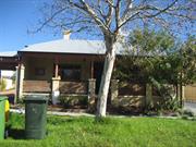
House, 3 Central Avenue, is an example of a single storey timber framed house dating from 1930 and is of cultural heritage significance for the following reasons; the place is of aesthetic value albeit altered, the original form remains intact and it contributes to the intact streetscape; the place has historic value as an example of a typical workers’ houses and living conditions from the Inter War period; it has social value as it contributes the community’s sense of place; and, it is representative of the typical workers' houses in the Fremantle area.
Central Avenue is located between South Street in the north and Lefroy Road in the south. House, 3 Central Avenue is situated on the western side the street. The streetscape comprises intact group of timber framed houses dating from the first decades of the twentieth century. The houses which form a significant group and contribute to the streetscape of Central Avenue include; 1, 3, 4, 6, 7, 9, 11, 13, 14, 15 &17. There are also some recent single storey residences. House, 3 Central Avenue is a single storey timber framed hipped roof house built originally with a symmetrical façade. The walls are clad with weatherboards which are possibly not original boards and the roof is clad with corrugated iron. The hipped roof is constructed over the front two rooms and a skillion roof is beyond. There is a brick chimney extant. The front verandah has been enclosed. The front entrance timber framed door and highlight window door remains within the enclosed front. The original windows have been removed. Internally, the front rooms have timber paneling to dado height and fibrous cement sheet walls with battens above. The ceilings have decorative cornices and ceiling roses. Timber floorboards are intact. There is a high brick fence to the front boundary fronting the garden. There is a brick pergola and shed at the rear of the site.
The land for Part of Crown Grant of 10 Acres was issued to Thomas Gardiner Yeoman of Fremantle in 1857. The land was advertised in the "Morning Herald" on 25th August 1885.The area was bounded by South Street, Fifth Avenue York Street and Cockburn location 67. The land was transferred to John, David and William Chester in 1892. In 1901 it was transferred to George Webb who subdivided the area in 1903. Lot 58 Cockburn location 62 was transferred to Erdman Heman Ernst. The Certificate of Title shows that in 1922 Eva Ettie Lang was listed as the owner. Note, some sources show Eva Ettie and some show Eva Hetty). In 1899 Matthew Alexander Lang (plumber) and Eva Hetty Loftus were married in Fremantle. The house was constructed for the Lang’s in 1930 and according to the Rates Books Matthew Lang is listed as the owner., although it appears that they resided in Hampton Road Fremantle. Matthew died in 1937 aged 69 and Eva Ettie died in 1967 aged 92. 3 Central Avenue (lot 58) was originally known as number 4 until the numbering changed in 1939/40. Wise Post Office Directories show that G. Gimblett was listed and resided there from 1939. In 1945 the property was transferred to Gerard and Victoria Gimblett. Gerard married Victoria Charlotte Kleesh in 1936 in Fremantle. Gerald was a tram driver. They had four children Gerard, Maureen, Paul (1941-1972) and Thomas. The Gimblett’s were still listed in 1949 in Wise’s which was the last year of its publication. It is believed they owned the property until 1977. The Metropolitan Sewerage map dated 1951 shows a four roomed weatherboard house at 3 Central Avenue. In 1977 the property was transferred to Edward William Allen (tyre fitter) and Joanne Rose Allen. In 2004 the property again changed ownership.
This information is provided voluntarily as a public service. The information provided is made available in good faith and is derived from sources believed to be reliable and accurate. However, the information is provided solely on the basis that readers will be responsible for making their own assessment of the matters discussed herein and are advised to verify all relevant representations, statements and information.
30 Central Av Beaconsfield
Fremantle
Metropolitan
| Type | Status | Date | Documents |
|---|---|---|---|
| (no listings) |
| Type | Status | Date | Documents |
|---|---|---|---|
| (no listings) |
| Type | Status | Date | Grading/Management | |
|---|---|---|---|---|
| Category | ||||
| (no listings) | ||||
Individual Building or Group
| Epoch | General | Specific |
|---|---|---|
| Present Use | RESIDENTIAL | Single storey residence |
| Original Use | RESIDENTIAL | Single storey residence |
| Type | General | Specific |
|---|---|---|
| Roof | METAL | Corrugated Iron |
| Wall | RENDER | Smooth |
| General | Specific |
|---|---|
| DEMOGRAPHIC SETTLEMENT & MOBILITY | Settlements |
This information is provided voluntarily as a public service. The information provided is made available in good faith and is derived from sources believed to be reliable and accurate. However, the information is provided solely on the basis that readers will be responsible for making their own assessment of the matters discussed herein and are advised to verify all relevant representations, statements and information.
Constructed from 1902, Constructed from 1903
Aesthetically significant as an example of Fremantle’s vernacular architecture. Typical single storey cottage dating from the first decades of the twentieth century. Historically significant as a representation of working people’s living conditions in the Fremantle area. Has undergone significant alterations but original form remains intact.
Single storey rendered and painted corrugated iron hipped roof house, sits below the pavement level. There are two tall rendered chimneys with corbelling and a bull nosed verandah which is supported turned timber posts between cast metal frieze. The following places form a significant group and contribute to the streetscape of Central Avenue; 25, 30, 33, 42 & 54.
On the 9th November 1857, Michael Mahor, a Yeoman of Fremantle was granted Country Enrolment No. 1091, which was later known as Cockburn Sound Location 67. This consisted off 10 acres and was bounded by Fifth Avenue on the West, Lefroy Road to the south, York Street on the east and Cockburn Sound Location 62 on the north. On 24 October 1892 ownership passed to a family of Fremantle butchers, John, David and William Chester, who had a slaughterhouse on part of the land. On 29 August 1901 the land was transferred to a Fremantle Land Agent named Reginald George Webb. Webb subdivided the land on the 8 November 1901 and further subdivisions occurred on 15 July 1903. When the land in this area was originally subdivided and put up for sale a competition was held to decide on a new name for the district and Hilton Park was chosen. In 1901/02 the land was vacant and by 1902/03 a cottage and shed had been built and was owned by William A Fearn, an agent. In 1909/10 a stable had been added an
| Ref ID No | Ref Name | Ref Source | Ref Date |
|---|---|---|---|
| MI not adopted - |
This information is provided voluntarily as a public service. The information provided is made available in good faith and is derived from sources believed to be reliable and accurate. However, the information is provided solely on the basis that readers will be responsible for making their own assessment of the matters discussed herein and are advised to verify all relevant representations, statements and information.
33 Central Av Beaconsfield
Fremantle
Metropolitan
| Type | Status | Date | Documents |
|---|---|---|---|
| Heritage List | YES | 08 Mar 2007 |
| Type | Status | Date | Documents |
|---|---|---|---|
| (no listings) |
| Type | Status | Date | Grading/Management | |
|---|---|---|---|---|
| Category | ||||
| Municipal Inventory | Adopted | 18 Sep 2000 | Level 3 | |
Individual Building or Group
| Epoch | General | Specific |
|---|---|---|
| Original Use | RESIDENTIAL | Single storey residence |
| Present Use | RESIDENTIAL | Single storey residence |
| Type | General | Specific |
|---|---|---|
| Wall | RENDER | Smooth |
| Roof | METAL | Corrugated Iron |
| General | Specific |
|---|---|
| DEMOGRAPHIC SETTLEMENT & MOBILITY | Settlements |
This information is provided voluntarily as a public service. The information provided is made available in good faith and is derived from sources believed to be reliable and accurate. However, the information is provided solely on the basis that readers will be responsible for making their own assessment of the matters discussed herein and are advised to verify all relevant representations, statements and information.
Constructed from 1902
Aesthetically significant as an example of Fremantle’s vernacular architecture. Typical single storey cottage dating from the first decades of the twentieth century. Historically significant as a representation of working people’s living conditions in the Fremantle area.
Single storey rendered and painted corrugated iron hipped roof house, sits below the pavement level. There are two tall rendered chimneys with corbelling and a bull nosed verandah which is supported turned timber posts between cast metal frieze. The following places form a significant group and contribute to the streetscape of Central Avenue; 25, 30, 33, 42 & 54.
On the 9th November 1857, Michael Mahor, a Yeoman of Fremantle was granted Country Enrolment No. 1091, which was later known as Cockburn Sound Location 67. This consisted of 10 acres and was bounded by Fifth Avenue on the West, Lefroy Road to the south, York Street on the east and Cockburn Sound Location 62 on the north. The land was advertised in the "Morning Herald" on 25th August 1885. On 24 October 1892 ownership passed to a family of Fremantle butchers, John, David and William Chester, who had a slaughterhouse on part of the land. On 29 August 1901 the land was transferred to a Fremantle Land Agent named Reginald George Webb. Webb subdivided the land on the 8 November 1901 and further subdivisions occurred on 15 July 1903 to create Lots 50, 51, 53, 54, 58, 59, 66, 67, 119 and 72. When the land in this area was originally subdivided and put up for sale a competition was held to decide on a new name for the district and Hilton Park was chosen. House, 33 Central Avenue: This lot is now 41/42 of 67. The 1902/ 03 Rate Book refers to a cottage on Lot 42 with Lot 41 vacant. A 1980 map shows a residence built over two lots. The 1986 Rate Book lists a residence on Lot 41 not 42. 1986 photographs are titled ‘to be demolished’ but the house then underwent conservation by 1989.
| Ref ID No | Ref Name | Ref Source | Ref Date |
|---|---|---|---|
| Conservation Incentives Award - |
This information is provided voluntarily as a public service. The information provided is made available in good faith and is derived from sources believed to be reliable and accurate. However, the information is provided solely on the basis that readers will be responsible for making their own assessment of the matters discussed herein and are advised to verify all relevant representations, statements and information.
39 Central Av Beaconsfield
Fremantle
Metropolitan
| Type | Status | Date | Documents |
|---|---|---|---|
| Heritage List | YES | 08 Mar 2007 |
| Type | Status | Date | Documents |
|---|---|---|---|
| (no listings) |
| Type | Status | Date | Grading/Management | |
|---|---|---|---|---|
| Category | ||||
| Municipal Inventory | Adopted | 18 Sep 2000 | Level 3 | |
Individual Building or Group
| Epoch | General | Specific |
|---|---|---|
| Present Use | RESIDENTIAL | Single storey residence |
| Original Use | RESIDENTIAL | Single storey residence |
| Style |
|---|
| Victorian Georgian |
| Type | General | Specific |
|---|---|---|
| Roof | METAL | Corrugated Iron |
| Wall | BRICK | Rendered Brick |
| General | Specific |
|---|---|
| DEMOGRAPHIC SETTLEMENT & MOBILITY | Settlements |
This information is provided voluntarily as a public service. The information provided is made available in good faith and is derived from sources believed to be reliable and accurate. However, the information is provided solely on the basis that readers will be responsible for making their own assessment of the matters discussed herein and are advised to verify all relevant representations, statements and information.
Constructed from 1913, Constructed from 1914
House, 39 Central Avenue, is a brick and iron single storey house dating from the 1910s. The place has aesthetic value for its contribution to the streetscape and the surrounding area. It is representative of the typical building stock located within the residential areas of Fremantle. It is historically significant as a representation of typical workers' houses in the Fremantle area. The place is a simple example of the Victorian Georgian style of architecture.
House, 39 Central Avenue is a single storey house with a symmetrical facade designed as simple example of the Victorian Georgian style of architecture. There is a high brick wall on the front boundary line making further description difficult. The walls are possibly rendered brick. The roof is hipped and clad with corrugated iron. The front elevation has a front door and timber framed casement windows. The verandah has a continuous corrugated iron roof and is supported by simple square timber posts. There is a brick chimney evident.
On the 9th November 1857, Michael Mahor, a Yeoman of Fremantle was granted Country Enrolment No. 1091, which was later known as Cockburn Sound Location 67. This consisted of 10 acres and was bounded by Fifth Avenue on the West, Lefroy Road to the south, York Street on the east and Cockburn Sound Location 62 on the north. The land was advertised in the "Morning Herald" on 25th August 1885. On 24 October 1892 ownership passed to a family of Fremantle butchers, John, David and William Chester, who had a slaughterhouse on part of the land. On 29 August 1901 the land was transferred to a Fremantle Land Agent named Reginald George Webb. Webb subdivided the land on the 8 November 1901 and further subdivisions occurred on 15 July 1903 to create Lots 50, 51, 53, 54, 58, 59, 66, 67, 119 and 72. When the land in this area was originally subdivided and put up for sale a competition was held to decide on a new name for the district and Hilton Park was chosen. House, 39 Central Avenue: From 1901 to 1912 Fanny Tingle was the owner of the vacant lot. The 1913/14 rate books record Elizabeth Stabler as the owner/occupier of No. 38 which was vacant and No. 39 a cottage. The following rate period of 1914/15 records Stabler as the owner of cottage and lot 38/39. In 1917/18 the next owner /occupier was William T Stabler who was listed as being the owner of Cottage and Sublots 38/39. By 1930/31 Frederick H. Berglund was the owner/occupier of vacant Lot 38 and house which was number 44. Numbering reverted to 39 in the 1939/40 rate period. Berglund was the owner of the house until circa 1949 when ownership changed to F. S. Bergland. The house was now known as residence 39 of Lot 38 of CSL 67. In 1986 the house was owned by Elizabeth N. Berglund.
High degree of integrity (original intent clear, current use compatible, high long term sustainability). Medium degree of authenticity with some original fabric remaining. (These statements based on street survey only).
Condition assessed as fair to good (assessed from streetscape survey only). There is a high brick wall on the front boundary line making condition notes difficult.
This information is provided voluntarily as a public service. The information provided is made available in good faith and is derived from sources believed to be reliable and accurate. However, the information is provided solely on the basis that readers will be responsible for making their own assessment of the matters discussed herein and are advised to verify all relevant representations, statements and information.
4 Central Av Beaconsfield
Fremantle
Metropolitan
| Type | Status | Date | Documents |
|---|---|---|---|
| Heritage List | YES | 08 Mar 2007 |
| Type | Status | Date | Documents |
|---|---|---|---|
| (no listings) |
| Type | Status | Date | Grading/Management | |
|---|---|---|---|---|
| Category | ||||
| Municipal Inventory | Adopted | 18 Sep 2000 | Level 3 | |
Individual Building or Group
| Epoch | General | Specific |
|---|---|---|
| Original Use | RESIDENTIAL | Single storey residence |
| Present Use | RESIDENTIAL | Single storey residence |
| Type | General | Specific |
|---|---|---|
| Wall | ASBESTOS | Fibrous Cement, flat |
| Roof | METAL | Zincalume |
| Wall | TIMBER | Weatherboard |
| General | Specific |
|---|---|
| DEMOGRAPHIC SETTLEMENT & MOBILITY | Settlements |
This information is provided voluntarily as a public service. The information provided is made available in good faith and is derived from sources believed to be reliable and accurate. However, the information is provided solely on the basis that readers will be responsible for making their own assessment of the matters discussed herein and are advised to verify all relevant representations, statements and information.
Constructed from 1930
Aesthetically significant as an example of Fremantle’s vernacular architecture. Typical timber framed single storey cottage dating from the first decades of the twentieth century. Historically significant as a representation of working people’s living conditions in the Fremantle area. Has undergone significant alterations but original form remains intact.
Single storey timber framed and weatherboard to dado height and rough cast clad walls above and a zincalume hipped and half timbered gable. The roof has a brick chimney with corbelling and extends over the verandah which is supported by timber posts. The following places form a significant group and contribute to the streetscape of Central Avenue; 1, 3, 4, 6, 7, 9, 11, 13, 14, 15 &17.
On the 9th November 1857, Michael Mahor, a Yeoman of Fremantle was granted Country Enrolment No. 1091, which was later known as Cockburn Sound Location 67. This consisted of 10 acres and was bounded by Fifth Avenue on the West, Lefroy Road to the south, York Street on the east and Cockburn Sound Location 62 on the north. The land was advertised in the "Morning Herald" on 25th August 1885. On 24 October 1892 ownership passed to a family of Fremantle butchers, John, David and William Chester, who had a slaughterhouse on part of the land. On 29 August 1901 the land was transferred to a Fremantle Land Agent named Reginald George Webb. Webb subdivided the land on the 8 November 1901 and further subdivisions occurred on 15 July 1903 to create Lots 50, 51, 53, 54, 58, 59, 66, 67, 119 and 72. When the land in this area was originally subdivided and put up for sale a competition was held to decide on a new name for the district and Hilton Park was chosen. House, 4 Central Avenue: The building was erected in 1930/31 on Lots 66 and 67 and given the number 4 of Lot 67 in 1940/41. In 1964 a builder order was submitted to reconstruct the front portion of the timber frame stable and repair the floor. In 1979 the Licence to maintain the stables was granted. James Norrie, a jockey, was the owner from 1926/7 to 1950.
This information is provided voluntarily as a public service. The information provided is made available in good faith and is derived from sources believed to be reliable and accurate. However, the information is provided solely on the basis that readers will be responsible for making their own assessment of the matters discussed herein and are advised to verify all relevant representations, statements and information.
42 Central Av Beaconsfield
Fremantle
Metropolitan
| Type | Status | Date | Documents |
|---|---|---|---|
| Heritage List | YES | 08 Mar 2007 |
| Type | Status | Date | Documents |
|---|---|---|---|
| (no listings) |
| Type | Status | Date | Grading/Management | |
|---|---|---|---|---|
| Category | ||||
| Municipal Inventory | Adopted | 18 Sep 2000 | Level 3 | |
Individual Building or Group
| Epoch | General | Specific |
|---|---|---|
| Original Use | RESIDENTIAL | Single storey residence |
| Present Use | RESIDENTIAL | Single storey residence |
| Type | General | Specific |
|---|---|---|
| Wall | RENDER | Other Render |
| Roof | METAL | Corrugated Iron |
| General | Specific |
|---|---|
| DEMOGRAPHIC SETTLEMENT & MOBILITY | Settlements |
This information is provided voluntarily as a public service. The information provided is made available in good faith and is derived from sources believed to be reliable and accurate. However, the information is provided solely on the basis that readers will be responsible for making their own assessment of the matters discussed herein and are advised to verify all relevant representations, statements and information.
Constructed from 1916
Aesthetically significant as an example of Fremantle’s vernacular architecture. Typical single storey cottage dating from the first decades of the twentieth century. Historically significant as a representation of working people’s living conditions in the Fremantle area. Has undergone significant alterations but original form remains intact.
Single storey rendered with ashlar effect and painted corrugated iron hipped roof house. The roof extends over the verandah which is supported by timber posts and has been semi-enclosed. The following places form a significant group and contribute to the streetscape of Central Avenue; 25, 30, 33, 42 & 54.
On the 9th November 1857, Michael Mahor, a Yeoman of Fremantle was granted Country Enrolment No. 1091, which was later known as Cockburn Sound Location 67. This consisted of 10 acres and was bounded by Fifth Avenue on the West, Lefroy Road to the south, York Street on the east and Cockburn Sound Location 62 on the north. The land was advertised in the "Morning Herald" on 25th August 1885. On 24 October 1892 ownership passed to a family of Fremantle butchers, John, David and William Chester, who had a slaughterhouse on part of the land. On 29 August 1901 the land was transferred to a Fremantle Land Agent named Reginald George Webb. Webb subdivided the land on the 8 November 1901 and further subdivisions occurred on 15 July 1903 to create Lots 50, 51, 53, 54, 58, 59, 66, 67, 119 and 72. When the land in this area was originally subdivided and put up for sale a competition was held to decide on a new name for the district and Hilton Park was chosen. House, 42 Central Avenue: The 1916/ 17 Rates Book lists a cottage on this lot (86 of 67) which is given the number 43 in 1934/ 35. The number changes to 42 in 1939/ 40. The Health Department issued a permit for a laundry addition in 1957 and for renovation in 1966.
This information is provided voluntarily as a public service. The information provided is made available in good faith and is derived from sources believed to be reliable and accurate. However, the information is provided solely on the basis that readers will be responsible for making their own assessment of the matters discussed herein and are advised to verify all relevant representations, statements and information.
54 Central Av Beaconsfield
Fremantle
Metropolitan
| Type | Status | Date | Documents |
|---|---|---|---|
| Heritage List | YES | 08 Mar 2007 |
| Type | Status | Date | Documents |
|---|---|---|---|
| (no listings) |
| Type | Status | Date | Grading/Management | |
|---|---|---|---|---|
| Category | ||||
| Municipal Inventory | Adopted | 18 Sep 2000 | Level 3 | |
Individual Building or Group
| Epoch | General | Specific |
|---|---|---|
| Original Use | RESIDENTIAL | Single storey residence |
| Present Use | RESIDENTIAL | Single storey residence |
| Type | General | Specific |
|---|---|---|
| Wall | TIMBER | Weatherboard |
| Roof | METAL | Other Metal |
| General | Specific |
|---|---|
| DEMOGRAPHIC SETTLEMENT & MOBILITY | Settlements |
This information is provided voluntarily as a public service. The information provided is made available in good faith and is derived from sources believed to be reliable and accurate. However, the information is provided solely on the basis that readers will be responsible for making their own assessment of the matters discussed herein and are advised to verify all relevant representations, statements and information.
Constructed from 1912
Aesthetically significant as an example of Fremantle’s vernacular architecture. Typical timber framed single storey cottage dating from the first decades of the twentieth century. Historically significant as a representation of working people’s living conditions in the Fremantle area.
Single storey timber framed and weatherboard clad walls and a Colorbond hipped roof house, has a brick chimney with corbelling. There is a bull nosed verandah supported by turned timber posts and weatherboard additions at the rear of the house. The following places form a significant group and contribute to the streetscape of Central Avenue; 25, 30, 33, 42 & 54.
On the 9th November 1857, Michael Mahor, a Yeoman of Fremantle was granted Country Enrolment No. 1091, which was later known as Cockburn Sound Location 67. This consisted of 10 acres and was bounded by Fifth Avenue on the West, Lefroy Road to the south, York Street on the east and Cockburn Sound Location 62 on the north. The land was advertised in the "Morning Herald" on 25th August 1885. On 24 October 1892 ownership passed to a family of Fremantle butchers, John, David and William Chester, who had a slaughterhouse on part of the land. On 29 August 1901 the land was transferred to a Fremantle Land Agent named Reginald George Webb. Webb subdivided the land on the 8 November 1901 and further subdivisions occurred on 15 July 1903 to create Lots 50, 51, 53, 54, 58, 59, 66, 67, 119 and 72. When the land in this area was originally subdivided and put up for sale a competition was held to decide on a new name for the district and Hilton Park was chosen. House, 54 Central Avenue: The 1912 /13 Rates Book lists a cottage on this lot (93 of 67) which is later given the number 54 in 1939/ 40. Horse shoes have been found in the grounds suggesting that horses may have been kept there.
This information is provided voluntarily as a public service. The information provided is made available in good faith and is derived from sources believed to be reliable and accurate. However, the information is provided solely on the basis that readers will be responsible for making their own assessment of the matters discussed herein and are advised to verify all relevant representations, statements and information.
6 Central Av Beaconsfield
Fremantle
Metropolitan
| Type | Status | Date | Documents |
|---|---|---|---|
| Heritage List | YES | 08 Mar 2007 |
| Type | Status | Date | Documents |
|---|---|---|---|
| (no listings) |
| Type | Status | Date | Grading/Management | |
|---|---|---|---|---|
| Category | ||||
| Municipal Inventory | Adopted | 18 Sep 2000 | Level 3 | |
Individual Building or Group
| Epoch | General | Specific |
|---|---|---|
| Present Use | RESIDENTIAL | Single storey residence |
| Original Use | RESIDENTIAL | Single storey residence |
| Type | General | Specific |
|---|---|---|
| Wall | TIMBER | Weatherboard |
| Roof | METAL | Zincalume |
| General | Specific |
|---|---|
| DEMOGRAPHIC SETTLEMENT & MOBILITY | Settlements |
This information is provided voluntarily as a public service. The information provided is made available in good faith and is derived from sources believed to be reliable and accurate. However, the information is provided solely on the basis that readers will be responsible for making their own assessment of the matters discussed herein and are advised to verify all relevant representations, statements and information.
Constructed from 1903
Aesthetically significant as an example of Fremantle’s vernacular architecture. Typical timber framed single storey cottage dating from the first decades of the twentieth century. Historically significant as a representation of working people’s living conditions in the Fremantle area.
Single storey timber framed and weatherboard clad walls and a zincalume hipped roof house. There are two chimneys with corbelling and a bull nosed verandah which is supported by turned timber posts. The following places form a significant group and contribute to the streetscape of Central Avenue; 1, 3, 4, 6, 7, 9, 11, 13, 14, 15 &17.
On the 9th November 1857, Michael Mahor, a Yeoman of Fremantle was granted Country Enrolment No. 1091, which was later known as Cockburn Sound Location 67. This consisted of 10 acres and was bounded by Fifth Avenue on the West, Lefroy Road to the south, York Street on the east and Cockburn Sound Location 62 on the north. The land was advertised in the "Morning Herald" on 25th August 1885. On 24 October 1892 ownership passed to a family of Fremantle butchers, John, David and William Chester, who had a slaughterhouse on part of the land. On 29 August 1901 the land was transferred to a Fremantle Land Agent named Reginald George Webb. Webb subdivided the land on the 8 November 1901 and further subdivisions occurred on 15 July 1903 to create Lots 50, 51, 53, 54, 58, 59, 66, 67, 119 and 72. When the land in this area was originally subdivided and put up for sale a competition was held to decide on a new name for the district and Hilton Park was chosen. House, 6 Central Avenue: A cottage was built on Lots 68 and 69 in 1903/04. The Rates books record an association with lots 118 and 119 also. There are several changes of Lot numbers. Stables were added in 1913. The house was extended in 1965.
This information is provided voluntarily as a public service. The information provided is made available in good faith and is derived from sources believed to be reliable and accurate. However, the information is provided solely on the basis that readers will be responsible for making their own assessment of the matters discussed herein and are advised to verify all relevant representations, statements and information.
7 Central Av Beaconsfield
Fremantle
Metropolitan
| Type | Status | Date | Documents |
|---|---|---|---|
| (no listings) |
| Type | Status | Date | Documents |
|---|---|---|---|
| (no listings) |
| Type | Status | Date | Grading/Management | |
|---|---|---|---|---|
| Category | ||||
| (no listings) | ||||
Individual Building or Group
| Epoch | General | Specific |
|---|---|---|
| Original Use | RESIDENTIAL | Single storey residence |
| Present Use | RESIDENTIAL | Single storey residence |
| Type | General | Specific |
|---|---|---|
| Roof | METAL | Zincalume |
| Wall | TIMBER | Weatherboard |
| General | Specific |
|---|---|
| DEMOGRAPHIC SETTLEMENT & MOBILITY | Settlements |
This information is provided voluntarily as a public service. The information provided is made available in good faith and is derived from sources believed to be reliable and accurate. However, the information is provided solely on the basis that readers will be responsible for making their own assessment of the matters discussed herein and are advised to verify all relevant representations, statements and information.
Constructed from 1902, Constructed from 1901
Aesthetic significance as a fine example of a brick residence in the Federation Queen Anne style probably built in the first decade of the twentieth century. Historical significance representing the increased wealth following the Gold Boom.
Single storey timber framed and weatherboard clad walls and a zincalume hipped and vented gable roofed house. The roof extends over the verandah which returns down the sides and is supported by timber posts and has timber balustrades. The following places form a significant group and contribute to the streetscape of Central Avenue; 1, 3, 4, 6, 7, 9, 11, 13, 14, 15 &17.
On the 9th November 1857, Michael Mahor, a Yeoman of Fremantle was granted Country Enrolment No. 1091, which was later known as Cockburn Sound Location 67. This consisted off 10 acres and was bounded by Fifth Avenue on the West, Lefroy Road to the south, York Street on the east and Cockburn Sound Location 62 on the north. On 24 October 1892 ownership passed to a family of Fremantle butchers, John, David and William Chester, who had a slaughterhouse on part of the land. On 29 August 1901 the land was transferred to a Fremantle Land Agent named Reginald George Webb. Webb subdivided the land on the 8 November 1901 and further subdivisions occurred on 15 July 1903. When the land in this area was originally subdivided and put up for sale a competition was held to decide on a new name for the district and Hilton Park was chosen. The house at 7 Central Avenue was built in the 1901/02 rate period. The house was owned by I. and M. Campbell and was Lot 55. Reginald George Webb was the first
| Ref ID No | Ref Name | Ref Source | Ref Date |
|---|---|---|---|
| MI not adopted - |
This information is provided voluntarily as a public service. The information provided is made available in good faith and is derived from sources believed to be reliable and accurate. However, the information is provided solely on the basis that readers will be responsible for making their own assessment of the matters discussed herein and are advised to verify all relevant representations, statements and information.
9 Central Av Beaconsfield
Fremantle
Metropolitan
| Type | Status | Date | Documents |
|---|---|---|---|
| Heritage List | YES | 08 Mar 2007 |
| Type | Status | Date | Documents |
|---|---|---|---|
| (no listings) |
| Type | Status | Date | Grading/Management | |
|---|---|---|---|---|
| Category | ||||
| Municipal Inventory | Adopted | 18 Sep 2000 | Level 3 | |
Individual Building or Group
| Epoch | General | Specific |
|---|---|---|
| Original Use | RESIDENTIAL | Single storey residence |
| Present Use | RESIDENTIAL | Single storey residence |
| Type | General | Specific |
|---|---|---|
| Wall | TIMBER | Weatherboard |
| Roof | METAL | Corrugated Iron |
| General | Specific |
|---|---|
| DEMOGRAPHIC SETTLEMENT & MOBILITY | Settlements |
This information is provided voluntarily as a public service. The information provided is made available in good faith and is derived from sources believed to be reliable and accurate. However, the information is provided solely on the basis that readers will be responsible for making their own assessment of the matters discussed herein and are advised to verify all relevant representations, statements and information.
Constructed from 1914
Aesthetically significant as an example of Fremantle’s vernacular architecture. Typical timber framed single storey cottage dating from the first decades of the twentieth century. Historically significant as a representation of working people’s living conditions in the Fremantle area.
Single storey timber framed and weatherboard walls and a painted corrugated iron hipped roof and brick chimney house. There is a dropped verandah which is supported by turned timber posts. The following places form a significant group and contribute to the streetscape of Central Avenue; 1, 3, 4, 6, 7, 9, 11, 13, 14, 15 &17.
On the 9th November 1857, Michael Mahor, a Yeoman of Fremantle was granted Country Enrolment No. 1091, which was later known as Cockburn Sound Location 67. This consisted of 10 acres and was bounded by Fifth Avenue on the West, Lefroy Road to the south, York Street on the east and Cockburn Sound Location 62 on the north. The land was advertised in the "Morning Herald" on 25th August 1885. On 24 October 1892 ownership passed to a family of Fremantle butchers, John, David and William Chester, who had a slaughterhouse on part of the land. On 29 August 1901 the land was transferred to a Fremantle Land Agent named Reginald George Webb. Webb subdivided the land on the 8 November 1901 and further subdivisions occurred on 15 July 1903 to create Lots 50, 51, 53, 54, 58, 59, 66, 67, 119 and 72. When the land in this area was originally subdivided and put up for sale a competition was held to decide on a new name for the district and Hilton Park was chosen. House, 9 Central Avenue: The Rate Books record a cottage in 1914/15 and this is given the number 12 in 1934/35. The number changed to 9 in 1939/40.
This information is provided voluntarily as a public service. The information provided is made available in good faith and is derived from sources believed to be reliable and accurate. However, the information is provided solely on the basis that readers will be responsible for making their own assessment of the matters discussed herein and are advised to verify all relevant representations, statements and information.
Clontarf Rd Beaconsfield
Fremantle
Metropolitan
| Type | Status | Date | Documents |
|---|---|---|---|
| Heritage List | YES | 08 Mar 2007 |
| Type | Status | Date | Documents |
|---|---|---|---|
| RHP - Does not warrant assessment | Current | 15 Feb 2023 |
| Type | Status | Date | Grading/Management | |
|---|---|---|---|---|
| Category | ||||
| Municipal Inventory | Adopted | 18 Sep 2000 | Landscape | |
Landscape
| Epoch | General | Specific |
|---|---|---|
| Original Use | PARK\RESERVE | Park\Reserve |
This information is provided voluntarily as a public service. The information provided is made available in good faith and is derived from sources believed to be reliable and accurate. However, the information is provided solely on the basis that readers will be responsible for making their own assessment of the matters discussed herein and are advised to verify all relevant representations, statements and information.
Clontarf Hill, originally set aside for the future expansion of suburban highways, has social value to the community, as evidence by Clontarf Action Group's efforts to stop the Eastern Bypass and conserve the area as undeveloped urban bushland.
Clontarf Rd was named by John Healy, the owner of the Winterfold Estate. His land comprised 300 acres north of Healy Rd, 200 acres south of Bibra Lake, and 100 acres in Spearwood. Winterfold Rd was gazetted a public highway in 1937. The reserve was part of a 2000 acre grant to George Robb in 1830. Robb developed a farm at the southern end of the reserve, near what is now Cardigan Street. In August 1830, the farm’s address was listed as Hamilton Hill, suggesting that the area now known as Clontarf Hill may have been the original Hamilton Hill for which the area east of there was later named. The 1913 PWD plan shows no buildings in the area, which is beyond the edge of the residential subdivision. A southeast section of the reserve was used for market gardening up to the 1950s. The reserve was not developed as it had been set aside for the future expansion of suburban highways, originally Roe Highway and later the much-protested Eastern Bypass, which was eventually abandoned in 1992. In 1993, the Clontarf Action Group described the place as a ‘relatively large area of publicly owned, undeveloped urban bushland’ and urged its conservation as it was no longer earmarked for future road use. The group noted that due to a lack of active management, with resulting dumping of rubbish, weed invasion, quarrying and human disturbance, the reserve had become degraded.
This information is provided voluntarily as a public service. The information provided is made available in good faith and is derived from sources believed to be reliable and accurate. However, the information is provided solely on the basis that readers will be responsible for making their own assessment of the matters discussed herein and are advised to verify all relevant representations, statements and information.
2 Clontarf Rd Beaconsfield
Fremantle
Metropolitan
| Type | Status | Date | Documents |
|---|---|---|---|
| Heritage List | YES | 08 Mar 2007 |
| Type | Status | Date | Documents |
|---|---|---|---|
| (no listings) |
| Type | Status | Date | Grading/Management | |
|---|---|---|---|---|
| Category | ||||
| Municipal Inventory | Adopted | 18 Sep 2000 | Historic/Archaeological Site | |
Individual Building or Group
| Epoch | General | Specific |
|---|---|---|
| Original Use | GOVERNMENTAL | Other |
This information is provided voluntarily as a public service. The information provided is made available in good faith and is derived from sources believed to be reliable and accurate. However, the information is provided solely on the basis that readers will be responsible for making their own assessment of the matters discussed herein and are advised to verify all relevant representations, statements and information.
DEMOLISHED- retained on MHI database for historical information purposes only.
DEMOLISHED- retained on MHI database for historical information purposes only.
This information is provided voluntarily as a public service. The information provided is made available in good faith and is derived from sources believed to be reliable and accurate. However, the information is provided solely on the basis that readers will be responsible for making their own assessment of the matters discussed herein and are advised to verify all relevant representations, statements and information.
3 Clontarf Rd Beaconsfield
Fremantle
Metropolitan
| Type | Status | Date | Documents |
|---|---|---|---|
| Heritage List | YES | 08 Mar 2007 |
| Type | Status | Date | Documents |
|---|---|---|---|
| (no listings) |
| Type | Status | Date | Grading/Management | |
|---|---|---|---|---|
| Category | ||||
| Municipal Inventory | Adopted | 18 Sep 2000 | ||
Individual Building or Group
| Epoch | General | Specific |
|---|---|---|
| Present Use | RESIDENTIAL | Single storey residence |
| Original Use | RESIDENTIAL | Single storey residence |
| Style |
|---|
| Inter-War California Bungalow |
| Type | General | Specific |
|---|---|---|
| Wall | BRICK | Rendered Brick |
| Roof | METAL | Corrugated Iron |
| General | Specific |
|---|---|
| DEMOGRAPHIC SETTLEMENT & MOBILITY | Settlements |
This information is provided voluntarily as a public service. The information provided is made available in good faith and is derived from sources believed to be reliable and accurate. However, the information is provided solely on the basis that readers will be responsible for making their own assessment of the matters discussed herein and are advised to verify all relevant representations, statements and information.
Constructed from 1946, Constructed from 1947
RECOMMENDED FOR DELETION 2010
House, 3 Clontarf Street has a recent high limestone block wall to the front boundary line making description from the street difficult. It appears to be is a single storey, brick, rendered masonry and tile house with an asymmetrical facade designed as an example of the Californian Bungalow style of architecture. The walls are rendered masonry. The roof is pitched and clad with tiles. There is a small verandah of corrugated iron.
Clontarf Rd was named by John Healy, the owner of the Winterfold Estate. His land comprised 300 acres north of Healy Rd, 200 acres south of Bibra Lake, and 100 acres in Spearwood. Winterfold Rd was gazetted a public highway in 1937. The land on which this house stands (3 Clontarf Road) was vacant in 1940/41 and owned by Eric James Luff. A shed was built on the lot in 1944/45 when the lot was owned by Ivan Covich. A house was built for Covich in 1946/47 and he remained owner/occupier until the early 1980s.
House, 3 Clontarf Road has a high limestone block wall to the front boundary line makes condition assessment from the street difficult.
The high limestone block wall to the front boundary line makes condition assessment from the street difficult.
This information is provided voluntarily as a public service. The information provided is made available in good faith and is derived from sources believed to be reliable and accurate. However, the information is provided solely on the basis that readers will be responsible for making their own assessment of the matters discussed herein and are advised to verify all relevant representations, statements and information.
Clontarf St Beaconsfield
Fremantle
Metropolitan
| Type | Status | Date | Documents |
|---|---|---|---|
| Heritage List | YES | 08 Mar 2007 |
| Type | Status | Date | Documents |
|---|---|---|---|
| (no listings) |
| Type | Status | Date | Grading/Management | |
|---|---|---|---|---|
| Category | ||||
| Municipal Inventory | Adopted | 18 Sep 2000 | Historic/Archaeological Site | |
Historic Site
| Epoch | General | Specific |
|---|---|---|
| Original Use | FARMING\PASTORAL | Other |
This information is provided voluntarily as a public service. The information provided is made available in good faith and is derived from sources believed to be reliable and accurate. However, the information is provided solely on the basis that readers will be responsible for making their own assessment of the matters discussed herein and are advised to verify all relevant representations, statements and information.
Site of market gardens, on the northy side of Clontarf Hill in an area now known as ‘Sardelic Park’ has social and historic significance as a site for market gardens operated by the Yugoslav migrant Sardelic family until 2006.
Clontarf Rd was named by John Healy, the owner of the Winterfold Estate. His land comprised 300 acres north of Healy Rd, 200 acres south of Bibra Lake, and 100 acres in Spearwood. Winterfold Rd was gazetted a public highway in 1937. The market gardens are on the north side of Clontarf Hill, in an area now known as ‘Sardelic Park’. Antun Sardelic came to WA from the former Yugoslavia in 1926, aged 25. After working on the goldfields he settled as a market gardener in Fremantle, developing 4 hectares of land on Clontarf Road. His sons Antun Jnr and Ivan also worked the farm, and continued to operate the market garden from this site until 2006. Antun Snr retired in 1956 and died in 2008.
This information is provided voluntarily as a public service. The information provided is made available in good faith and is derived from sources believed to be reliable and accurate. However, the information is provided solely on the basis that readers will be responsible for making their own assessment of the matters discussed herein and are advised to verify all relevant representations, statements and information.
13 Curedale St Beaconsfield
Fremantle
Metropolitan
| Type | Status | Date | Documents |
|---|---|---|---|
| Heritage List | YES | 08 Mar 2007 |
| Type | Status | Date | Documents |
|---|---|---|---|
| (no listings) |
| Type | Status | Date | Grading/Management | |
|---|---|---|---|---|
| Category | ||||
| Municipal Inventory | Adopted | Level 3 | ||
Individual Building or Group
| Epoch | General | Specific |
|---|---|---|
| Original Use | RESIDENTIAL | Single storey residence |
| Present Use | RESIDENTIAL | Single storey residence |
| Type | General | Specific |
|---|---|---|
| Roof | METAL | Zincalume |
| Wall | STONE | Limestone |
| General | Specific |
|---|---|
| DEMOGRAPHIC SETTLEMENT & MOBILITY | Settlements |
This information is provided voluntarily as a public service. The information provided is made available in good faith and is derived from sources believed to be reliable and accurate. However, the information is provided solely on the basis that readers will be responsible for making their own assessment of the matters discussed herein and are advised to verify all relevant representations, statements and information.
Constructed from 1908
House, 13 Curedale Street, is a single storey limestone and iron house dating from 1908. It has aesthetic value for its contribution to the streetscape and the surrounding area. It is representative of the typical building stock and of working people’s living conditions within the residential areas of Fremantle. The place is significant as a fine example of Fremantle’s vernacular architecture.
House, 13 single storey limestone and brick quoining and a Zincalume hipped roof house constructed in the late Victorian Georgian style of architecture. There is a brick chimney with corbelling and the separate roof verandah is supported by pairs of metal columns with detailing between which are not original. The entrance door and fanlight and sidelights and is flanked by pairs of timber framed sash windows. There is a face brick fence with piers, some with timber pickets to the front boundary.
The land on which Curedale Street and the Grosvenor Hospital are situated originally belonged to the Curedale family. George Curedale arrived in Fremantle as a convict on 1st January 1858. On 18 May 1881 George Curedale purchased 82 acres, about three kilometres from the centre of Fremantle, from Henry Maxwell Lefroy who had died two years previously. The property comprised four adjoining Cockburn Sound Location Lots and was located between the present Curedale Street, east to within 4.45 chains of Fifth Avenue and from South Street to Lefroy Street. Curedale developed the land as an orchard and vineyard. Having earned a living as ‘Fruiterer’ and then ‘Green-grocer’, George Curedale now described himself as ‘Vineyard Proprietor’ and there is evidence to show that he did import vines. The property was owned by the Curedales until 28 April 1887 when Lots 59, 60, 61 and 66 were transferred to George Alfred Davies (1846 – 1847) to clear George Curedale’s debts. George Curedale died of heart disease, on 15th August 1887. The adjoining Davies Street is named for the Davies family. Davies Street adjoins Curedale Street. A house is first recorded on this lot in 1908/9. William J Webb was the first occupant. The 1908 sewerage map (No. 87) shows a stone house with a projecting room on the right hand side at the front and central steps. The rear verandah was enclosed at each end with weatherboard, and there was another weatherboard outbuilding attached on the north west corner. The house was originally number 33, and became number 13 when the whole street was renumbered in 1937. From 1930 the owner/occupant is Henry Herbert Panton, there until at least 1949 (when post office directory records cease) The 1947 aerial photograph (Landgate) shows a square house with a hipped roof. Later aerial photos (Landgate) show that the roof was all painted red corrugated iron. The roof was replaced c1982. Between 1985 and 1995 the house was extended to the rear. Circa 2004 the separate dropped verandah roof was restored to the original red corrugated iron.
This information is provided voluntarily as a public service. The information provided is made available in good faith and is derived from sources believed to be reliable and accurate. However, the information is provided solely on the basis that readers will be responsible for making their own assessment of the matters discussed herein and are advised to verify all relevant representations, statements and information.
14 Curedale St Beaconsfield
Fremantle
Metropolitan
| Type | Status | Date | Documents |
|---|---|---|---|
| Heritage List | YES | 08 Mar 2007 |
| Type | Status | Date | Documents |
|---|---|---|---|
| RHP - Does not warrant assessment | Current | 25 Feb 2005 |
| Type | Status | Date | Grading/Management | |
|---|---|---|---|---|
| Category | ||||
| Municipal Inventory | Adopted | 18 Sep 2000 | Level 3 | |
| Library Id | Title | Medium | Year Of Publication |
|---|---|---|---|
| 7214 | Fremantle eastern bypass : archival reports. | Archival Record | 2004 |
| 7372 | Eastern bypass : archival reports. | C D Rom | 2004 |
Individual Building or Group
| Epoch | General | Specific |
|---|---|---|
| Original Use | RESIDENTIAL | Single storey residence |
| Type | General | Specific |
|---|---|---|
| Roof | METAL | Zincalume |
| Wall | TIMBER | Weatherboard |
| General | Specific |
|---|---|
| DEMOGRAPHIC SETTLEMENT & MOBILITY | Settlements |
This information is provided voluntarily as a public service. The information provided is made available in good faith and is derived from sources believed to be reliable and accurate. However, the information is provided solely on the basis that readers will be responsible for making their own assessment of the matters discussed herein and are advised to verify all relevant representations, statements and information.
Constructed from 1904
House, 14 Curedale Street, is a single storey timber and iron house dating from 1904. It has aesthetic value for its contribution to the streetscape and the surrounding area. It is representative of the typical building stock and of working people’s living conditions within the residential areas of Fremantle. The place is significant as an example of Fremantle’s vernacular architecture.
House, 14 Curedale Street single storey timber framed and weatherboard clad walls and a Zincalume hipped roof house. The façade is symmetrical and the central entrance door has fanlight and sidelights and is flanked by timber framed double hung sash windows. The dropped verandah is supported by turned timber posts. There is a limestone fence with piers and metal infill to the front boundary.
The land on which Curedale Street and the Grosvenor Hospital are situated originally belonged to the Curedale family. George Curedale arrived in Fremantle as a convict on 1st January 1858. On 18 May 1881 George Curedale purchased 82 acres, about three kilometres from the centre of Fremantle, from Henry Maxwell Lefroy who had died two years previously. The property comprised four adjoining Cockburn Sound Location Lots and was located between the present Curedale Street, east to within 4.45 chains of Fifth Avenue and from South Street to Lefroy Street. Curedale developed the land as an orchard and vineyard. Having earned a living as ‘Fruiterer’ and then ‘Green-grocer’, George Curedale now described himself as ‘Vineyard Proprietor’ and there is evidence to show that he did import vines. The property was owned by the Curedales until 28 April 1887 when Lots 59, 60, 61 and 66 were transferred to George Alfred Davies (1846 – 1847) to clear George Curedale’s debts. George Curedale died of heart disease, on 15th August 1887. The adjoining Davies Street is named for the Davies family. Davies Street adjoins Curedale Street. The Rates Book records a cottage in 1904. The first occupant to c1920 was John A Chambers. Another long-term resident was Eric Cole (1937 to at least 1949). The 1908 sewerage map (No. 87) shows a weatherboard house with a full length front verandah and a half-length verandah a t the rea, with steps leading down to the back yard where there were two timber outbuildings; one on each side boundary fence. The house was originally number 28, and became number 14 when the whole street was renumbered in 1937. The 1947 aerial photograph (Landgate) shows a simple hipped roof house with a skillion to the rear. Later aerial photos (Landgate) show that c2008 the roof was modified and extended to the rear.
This information is provided voluntarily as a public service. The information provided is made available in good faith and is derived from sources believed to be reliable and accurate. However, the information is provided solely on the basis that readers will be responsible for making their own assessment of the matters discussed herein and are advised to verify all relevant representations, statements and information.
15 Curedale St Beaconsfield
Fremantle
Metropolitan
| Type | Status | Date | Documents |
|---|---|---|---|
| Heritage List | YES | 08 Mar 2007 |
| Type | Status | Date | Documents |
|---|---|---|---|
| (no listings) |
| Type | Status | Date | Grading/Management | |
|---|---|---|---|---|
| Category | ||||
| Municipal Inventory | Adopted | 18 Sep 2000 | Level 3 | |
Individual Building or Group
| Epoch | General | Specific |
|---|---|---|
| Original Use | RESIDENTIAL | Conjoined residence |
| Present Use | RESIDENTIAL | Conjoined residence |
| Type | General | Specific |
|---|---|---|
| Roof | METAL | Zincalume |
| Wall | RENDER | Smooth |
| General | Specific |
|---|---|
| DEMOGRAPHIC SETTLEMENT & MOBILITY | Settlements |
This information is provided voluntarily as a public service. The information provided is made available in good faith and is derived from sources believed to be reliable and accurate. However, the information is provided solely on the basis that readers will be responsible for making their own assessment of the matters discussed herein and are advised to verify all relevant representations, statements and information.
Constructed from 1908
Duplex 15 – 17 Curedale Street, is a single storey stone and iron house dating from 1908. While the place has undergone alteration, is has aesthetic value for its contribution to the streetscape and the surrounding area. It is representative of the typical building stock and of working people’s living conditions within the residential areas of Fremantle. The place is significant as an example of Fremantle’s vernacular architecture.
Duplex 15 – 17 Curedale Street comprises single storey rendered and Zincalume hipped roof residences. The separate verandah has a tiled roofed and is supported by pairs of metal columns, which are probably not original. Windows are timber framed although also probably also not original. There is a low metal fence to the front boundary. Although elements of the duplex has been altered the original form is evident.
The land on which Curedale Street and the Grosvenor Hospital are situated originally belonged to the Curedale family. George Curedale arrived in Fremantle as a convict on 1st January 1858. On 18 May 1881 George Curedale purchased 82 acres, about three kilometres from the centre of Fremantle, from Henry Maxwell Lefroy who had died two years previously. The property comprised four adjoining Cockburn Sound Location Lots and was located between the present Curedale Street, east to within 4.45 chains of Fifth Avenue and from South Street to Lefroy Street. Curedale developed the land as an orchard and vineyard. Having earned a living as ‘Fruiterer’ and then ‘Green-grocer’, George Curedale now described himself as ‘Vineyard Proprietor’ and there is evidence to show that he did import vines. The property was owned by the Curedales until 28 April 1887 when Lots 59, 60, 61 and 66 were transferred to George Alfred Davies (1846 – 1847) to clear George Curedale’s debts. George Curedale died of heart disease, on 15th August 1887. The adjoining Davies Street is named for the Davies family. Davies Street adjoins Curedale Street. Two cottages are listed on lot 20 of CSL 7 in 1908/9. The first occupants were William Cooper (No. 15) and Frederick A, Cooper (No. 17) who lived there until 1918. The 1908 sewerage map (No. 87) shows the stone attached pair, which have central steps abutting in the centre of the building, wider at the ground level than at the verandah. and full-length front and rear verandahs. The duplex was originally numbers 35-37, and became numbers 15-17 when the whole street was renumbered in 1937. Aerial photos (Landgate) show that the place appears to have been reroofed in the late 1970s (except for the separate verandah roof). The rear of the properties was remodelled and extended between 1985 and 1995.
This information is provided voluntarily as a public service. The information provided is made available in good faith and is derived from sources believed to be reliable and accurate. However, the information is provided solely on the basis that readers will be responsible for making their own assessment of the matters discussed herein and are advised to verify all relevant representations, statements and information.
17 Curedale St Beaconsfield
Fremantle
Metropolitan
| Type | Status | Date | Documents |
|---|---|---|---|
| Heritage List | YES | 08 Mar 2007 |
| Type | Status | Date | Documents |
|---|---|---|---|
| (no listings) |
| Type | Status | Date | Grading/Management | |
|---|---|---|---|---|
| Category | ||||
| Municipal Inventory | Adopted | 18 Sep 2000 | Level 3 | |
Individual Building or Group
| Epoch | General | Specific |
|---|---|---|
| Present Use | RESIDENTIAL | Conjoined residence |
| Original Use | RESIDENTIAL | Conjoined residence |
| Type | General | Specific |
|---|---|---|
| Roof | METAL | Zincalume |
| Wall | RENDER | Smooth |
| General | Specific |
|---|---|
| DEMOGRAPHIC SETTLEMENT & MOBILITY | Settlements |
This information is provided voluntarily as a public service. The information provided is made available in good faith and is derived from sources believed to be reliable and accurate. However, the information is provided solely on the basis that readers will be responsible for making their own assessment of the matters discussed herein and are advised to verify all relevant representations, statements and information.
Constructed from 1908
Duplex 15 – 17 Curedale Street, is a single storey stone and iron house dating from 1908. While the place has undergone alteration, is has aesthetic value for its contribution to the streetscape and the surrounding area. It is representative of the typical building stock and of working people’s living conditions within the residential areas of Fremantle. The place is significant as an example of Fremantle’s vernacular architecture.
Duplex 15 – 17 Curedale Street comprises single storey rendered and Zincalume hipped roof residences. The separate verandah has a tiled roofed and is supported by pairs of metal columns, which are probably not original. Windows are timber framed although also probably also not original. There is a low metal fence to the front boundary. Although elements of the duplex has been altered the original form is evident
The land on which Curedale Street and the Grosvenor Hospital are situated originally belonged to the Curedale family. George Curedale arrived in Fremantle as a convict on 1st January 1858. On 18 May 1881 George Curedale purchased 82 acres, about three kilometres from the centre of Fremantle, from Henry Maxwell Lefroy who had died two years previously. The property comprised four adjoining Cockburn Sound Location Lots and was located between the present Curedale Street, east to within 4.45 chains of Fifth Avenue and from South Street to Lefroy Street. Curedale developed the land as an orchard and vineyard. Having earned a living as ‘Fruiterer’ and then ‘Green-grocer’, George Curedale now described himself as ‘Vineyard Proprietor’ and there is evidence to show that he did import vines. The property was owned by the Curedales until 28 April 1887 when Lots 59, 60, 61 and 66 were transferred to George Alfred Davies (1846 – 1847) to clear George Curedale’s debts. George Curedale died of heart disease, on 15th August 1887. The adjoining Davies Street is named for the Davies family. Davies Street adjoins Curedale Street. Two cottages are listed on lot 20 of CSL 7 in 1908/9. The first occupants were William Cooper (No. 15) and Frederick A, Cooper (No. 17) who lived there until 1918. The 1908 sewerage map (No. 87) shows the stone attached pair, which have central steps abutting in the centre of the building, wider at the ground level than at the verandah. and full-length front and rear verandahs. The duplex was originally numbers 35-37, and became numbers 15-17 when the whole street was renumbered in 1937. Aerial photos (Landgate) show that the place appears to have been reroofed in the late 1970s (except for the separate verandah roof). The rear of the properties was remodelled and extended between 1985 and 1995.
This information is provided voluntarily as a public service. The information provided is made available in good faith and is derived from sources believed to be reliable and accurate. However, the information is provided solely on the basis that readers will be responsible for making their own assessment of the matters discussed herein and are advised to verify all relevant representations, statements and information.
18 Curedale St Beaconsfield
Fremantle
Metropolitan
| Type | Status | Date | Documents |
|---|---|---|---|
| Heritage List | YES | 08 Mar 2007 |
| Type | Status | Date | Documents |
|---|---|---|---|
| (no listings) |
| Type | Status | Date | Grading/Management | |
|---|---|---|---|---|
| Category | ||||
| Municipal Inventory | Adopted | 18 Sep 2000 | Level 3 | |
Individual Building or Group
| Epoch | General | Specific |
|---|---|---|
| Original Use | RESIDENTIAL | Single storey residence |
| Style |
|---|
| Victorian Georgian |
| Type | General | Specific |
|---|---|---|
| Wall | ASBESTOS | Fibrous Cement, flat |
| Wall | TIMBER | Weatherboard |
| Roof | METAL | Corrugated Iron |
| General | Specific |
|---|---|
| DEMOGRAPHIC SETTLEMENT & MOBILITY | Settlements |
This information is provided voluntarily as a public service. The information provided is made available in good faith and is derived from sources believed to be reliable and accurate. However, the information is provided solely on the basis that readers will be responsible for making their own assessment of the matters discussed herein and are advised to verify all relevant representations, statements and information.
Constructed from 1905
House, 18 Curedale Street, is a timber and iron single storey house dating from 1905. The place has aesthetic value for its contribution to the streetscape and the surrounding area. It is representative of the typical building stock located within the residential areas of Beaconsfield. It is historically significant as a representation of typical workers' houses in the Beaconsfield area. The place is an example of the Victorian Georgian style of architecture.
House, 18 Curedale Road is a single storey timber and iron house designed as an example of the Victorian Georgian style of architecture. The walls are timber framed and clad with painted weatherboard. The roof is hipped and clad with corrugated iron. The façade is symmetrical with a central front door flanked on either side by timber framed windows. The verandah has a separate dropped corrugated iron roof supported by steel poles. There is a high steel fence to the front boundary line.
The land on which Curedale Street and the Grosvenor Hospital are situated originally belonged to the Curedale family. George Curedale arrived in Fremantle as a convict on 1st January 1858. On 18 May 1881 George Curedale purchased 82 acres, about three kilometres from the centre of Fremantle, from Henry Maxwell Lefroy who had died two years previously. The property comprised four adjoining Cockburn Sound Location Lots and was located between the present Curedale Street, east to within 4.45 chains of Fifth Avenue and from South Street to Lefroy Street. Curedale developed the land as an orchard and vineyard. Having earned a living as ‘Fruiterer’ and then ‘Green-grocer’, George Curedale now described himself as ‘Vineyard Proprietor’ and there is evidence to show that he did import vines. The property was owned by the Curedales until 28 April 1887 when Lots 59, 60, 61 and 66 were transferred to George Alfred Davies (1846 – 1847) to clear George Curedale’s debts. George Curedale died of heart disease, on 15th August 1887. The adjoining Davies Street is named for the Davies family. Davies Street adjoins Curedale Street. The land on which house 18 Curedale Street stands was vacant in 1901/02 and owned by L. Weiusberg. By 1903/04 the vacant land, Lot 12 of Cockburn Sound Location 59 belonged to George Peach, a baker. In the following rate period, a cottage had been built on the lot for Peach, who remained the owner into the 1920s. Peach lived in the cottage from 1905-1915. From 1915-c1923 Frederick Gulvin was his tenant. The 1908 sewerage map (No. 87) shows a large weatherboard residence with a full-length front verandah. A long set of steps led down to the back yard where there was a galvanised iron outbuilding on the north boundary fence. The house became number 18 when the whole street was renumbered in 1937. From 1935-1945 John Joseph Tapper was the owner/occupier and from 1949 Ernest L Hansen and Winifred Gladys Hansen were the owners/occupiers. Later aerial photos (Landgate) show that the house was reroofed in the late 2000s.
High degree of integrity (original intent clear, current use compatible, high long term sustainability). High degree of authenticity with much original fabric remaining. (These statements based on street survey only).
Condition assessed as fair (assessed from streetscape survey only).
This information is provided voluntarily as a public service. The information provided is made available in good faith and is derived from sources believed to be reliable and accurate. However, the information is provided solely on the basis that readers will be responsible for making their own assessment of the matters discussed herein and are advised to verify all relevant representations, statements and information.
19 Curedale St Beaconsfield
Fremantle
Metropolitan
| Type | Status | Date | Documents |
|---|---|---|---|
| Heritage List | YES | 08 Mar 2007 |
| Type | Status | Date | Documents |
|---|---|---|---|
| (no listings) |
| Type | Status | Date | Grading/Management | |
|---|---|---|---|---|
| Category | ||||
| Municipal Inventory | Adopted | 18 Sep 2000 | Level 3 | |
Individual Building or Group
| Epoch | General | Specific |
|---|---|---|
| Present Use | RESIDENTIAL | Two storey residence |
| Original Use | RESIDENTIAL | Single storey residence |
| Style |
|---|
| Victorian Georgian |
| Type | General | Specific |
|---|---|---|
| Wall | STONE | Limestone |
| Roof | METAL | Corrugated Iron |
| General | Specific |
|---|---|
| DEMOGRAPHIC SETTLEMENT & MOBILITY | Settlements |
This information is provided voluntarily as a public service. The information provided is made available in good faith and is derived from sources believed to be reliable and accurate. However, the information is provided solely on the basis that readers will be responsible for making their own assessment of the matters discussed herein and are advised to verify all relevant representations, statements and information.
Constructed from 1892
House, 19 Curedale Street, is a limestone and iron single storey house dating from the early 1890s. The place has aesthetic value for its contribution to the streetscape and the surrounding area. It is representative of the typical building stock located within the residential areas of Beaconsfield. It is historically significant as a representation of typical workers' houses in the Beaconsfield area. The place is a simple example of the Victorian Georgian style of architecture.
House, 19 Curedale Street is a single storey, rendered house with a symmetrical facade designed as a simple example of the Victorian Georgian style of architecture. The walls are rendered limestone. The roof is hipped and clad with corrugated iron. The front elevation has a central front door flanked on either side by fixed pane and casement windows. The verandah has a continuous corrugated iron roof and is supported by simple square timber posts on rendered pillars with a steel balustrade enclosed with bamboo sheeting. The edge of the verandah sits on the front boundary line. The house is slightly elevated from street level with a small set of steps leading to the verandah. There are two rendered corbelled chimneys evident. There is a carport addition to the southern side of the house.
The land on which Curedale Street and the Grosvenor Hospital are situated originally belonged to the Curedale family. George Curedale arrived in Fremantle as a convict on 1st January 1858. On 18 May 1881 George Curedale purchased 82 acres, about three kilometres from the centre of Fremantle, from Henry Maxwell Lefroy who had died two years previously. The property comprised four adjoining Cockburn Sound Location Lots and was located between the present Curedale Street, east to within 4.45 chains of Fifth Avenue and from South Street to Lefroy Street. Curedale developed the land as an orchard and vineyard. Having earned a living as ‘Fruiterer’ and then ‘Green-grocer’, George Curedale now described himself as ‘Vineyard Proprietor’ and there is evidence to show that he did import vines. The property was owned by the Curedales until 28 April 1887 when Lots 59, 60, 61 and 66 were transferred to George Alfred Davies (1846 – 1847) to clear George Curedale’s debts. George Curedale died of heart disease, on 15th August 1887. The adjoining Davies Street is named for the Davies family. Davies Street adjoins Curedale Street. A two-room cottage was built on this site in 1892 for William Oaten. Oaten lived at the place until 1897. He is listed as a carter or a lime burner. Oaten married Margaret Ellen Curedale, daughter of George Curedale. In 1898 the cottage on site is recorded as three rooms. As an occupant is noted for the year, it is likely this was an extension to the original cottage rather than demolition and replacement with a larger building. From 1899 to the 1910s the place was owned and occupied by William Chester, a butcher. The 1908 sewerage plan (No. 87) shows the stone cottage with a verandah across its full front elevation and a small rear verandah flanked by two timber rooms. There was a timber outbuilding on the southern boundary fence, level with the house. The house was originally number 39, and became number 19 when the whole street was renumbered in 1937. James Bee owned and occupied the place in 1920. It passed to Frederick George Bray in 1922. A patio was added to the left of the house in 1974. The house by this time appears to have had a sleep out or similar room added across the rear façade. Mrs Alice Bray was till in the house in 1949 (when post office directory records cease). The 1981 aerial photograph (Landgate) shows a hipped and gabled roof house with a carport attached on the south side and a large, lawned back yard. Photographs taken in 1979 and 1993 show the place unchanged. It has a hipped tile roof extending over a skillion verandah. Rough-rendered masonry verandah walls infill between concrete posts, and concrete steps provide access in the centre of the façade. As the style and arrangement of pot plants in front of the house is similar in both photographs, it is likely that occupants have remained the same. An undated photograph of the rear of the house shows a tile-roof verandah completely enclosed with rendered brickwork. The rear yard is entirely cleared, as for a new development, with the exception of a brick outdoor toilet. Later aerial photos (Landgate) show that between 1985 and 1995 the lot was subdivided and another house built at the rear(19a). The house was extended at the rear. In 1995 the place was advertised for sale as a renovated ‘farmhouse’ … ‘three double-bedroom home’, retaining three fireplaces, polished floorboards and ‘ornate’ ceiling details. A modern extension has been added to the rear. A two-storey loft residence has also been built on the rear of the block. The advertisement claims the place was ‘vacant and derelict for many years’, but the 1993 photograph mentioned above shows it clearly lived in and cared for. A 1995 photograph shows the roof reclad with corrugated iron, the front verandah remodelled, and a larger patio with brick pillars replacing the 1974 patio. As at 2017 the house is for sale and real estate advertisements online describe “a substantial limestone and iron home from prior to 1900 with 3 huge bedrooms and large lounge all with high ceilings, jarrah floors and thick limestone internal walls. There is a very deep, very usable front verandah elevated off the street and a very private walled courtyard, plus undercover parking.”
High degree of integrity (original intent clear, current use compatible, high long term sustainability). Medium degree of authenticity with some original fabric remaining. (These statements based on street survey only).
Condition assessed as good (assessed from streetscape survey only).
This information is provided voluntarily as a public service. The information provided is made available in good faith and is derived from sources believed to be reliable and accurate. However, the information is provided solely on the basis that readers will be responsible for making their own assessment of the matters discussed herein and are advised to verify all relevant representations, statements and information.