Local Government
Toodyay
Region
Avon Arc
S of Culham
South of Culham GPS: Site 1 0447047 6514853 Site 2 0447174 6514740
Chinese Market Gardens
Toodyay
Avon Arc
Constructed from 1913
| Type | Status | Date | Documents |
|---|---|---|---|
| (no listings) |
| Type | Status | Date | Documents |
|---|---|---|---|
| (no listings) |
| Type | Status | Date | Grading/Management | |
|---|---|---|---|---|
| Category | ||||
| Municipal Inventory | Adopted | 27 Aug 1998 | Category 5 | |
Historic Site
| Epoch | General | Specific |
|---|---|---|
| Original Use | FARMING\PASTORAL | Other |
| Present Use | FARMING\PASTORAL | Other |
| General | Specific |
|---|---|
| DEMOGRAPHIC SETTLEMENT & MOBILITY | Immigration, emigration & refugees |
| OCCUPATIONS | Rural industry & market gardening |
This information is provided voluntarily as a public service. The information provided is made available in good faith and is derived from sources believed to be reliable and accurate. However, the information is provided solely on the basis that readers will be responsible for making their own assessment of the matters discussed herein and are advised to verify all relevant representations, statements and information.
The site has historic value for the associations with the railways and Chinese market gardens in the area. The site has research value as it has potential to contain subsurface archaeological remains.
There was no tangible evidence marking the location of the former siding.
A. Lloyd and his brother David took up Coondle subdivision in about 1899. In 1913, David Lloyd sold 80 acres of his land to Yock Lunn, a Chinese gardener. Until that time, Lunn had leased land at 'Nardie'. He was a man of some standing in the Western Australian Chinese Community and had acted on the Chinese Consul's behalf in occasions. He later took over Donegan's Store and set up a vegetable shop in Toodyay. He sent cauliflowers and cabbages to Kalgoorlie by train and the siding near his home was called Lunn's Landing. The market gardens were still there in the late 1940's. Mr Yock Lunn lived there for many years until he returned to China.
None
This information is provided voluntarily as a public service. The information provided is made available in good faith and is derived from sources believed to be reliable and accurate. However, the information is provided solely on the basis that readers will be responsible for making their own assessment of the matters discussed herein and are advised to verify all relevant representations, statements and information.
Cnr Telegraph & Toodyay-Bindi Bindi Rd Culham
GPS: 0450330 6524586
Toodyay
Avon Arc
Constructed from 1899
| Type | Status | Date | Documents |
|---|---|---|---|
| Heritage List | Adopted | 01 Dec 2012 |
| Type | Status | Date | Documents |
|---|---|---|---|
| (no listings) |
| Type | Status | Date | Grading/Management | |
|---|---|---|---|---|
| Category | ||||
| Municipal Inventory | Adopted | 27 Aug 1998 | Category 3 | |
Historic Site
| Epoch | General | Specific |
|---|---|---|
| Present Use | SOCIAL\RECREATIONAL | Other |
| Original Use | SOCIAL\RECREATIONAL | Other |
| General | Specific |
|---|---|
| SOCIAL & CIVIC ACTIVITIES | Sport, recreation & entertainment |
This information is provided voluntarily as a public service. The information provided is made available in good faith and is derived from sources believed to be reliable and accurate. However, the information is provided solely on the basis that readers will be responsible for making their own assessment of the matters discussed herein and are advised to verify all relevant representations, statements and information.
Constructed from 1899
The site has historic value for the associations with generations of Culham settlers who gathered for social, community and recreational activities. The site has research value as it has potential to contain subsurface archaeological remains.
Some possible remnants of the cricket ground remains but nothing wholly discernible was found.
The Toodyay Valley settlers initially formed and met in the 1890's to raise funds for school purposes and a meeting hall. They revived the custom of ploughing matches at 'Culham' and 'Hawthornden'. The club qualified for the government grant for a hall and then changed their focus to the proposed railway. The Culham Hall was built on the northern boundary of the 'Culham' Estate at the Plains Road Boundary and opened in May 1899. The opening was celebrated with a cricket match against the Victoria Plains team and a ball in in the evening. This match and many subsequent matches were held at this site. In 1979, a cricket match between the old cricket clubs was played at the site.
None
| Owner | Category |
|---|---|
| Mr. Horvath | Other Private |
This information is provided voluntarily as a public service. The information provided is made available in good faith and is derived from sources believed to be reliable and accurate. However, the information is provided solely on the basis that readers will be responsible for making their own assessment of the matters discussed herein and are advised to verify all relevant representations, statements and information.
Toodyay-Bindi Bindi Rd Culham
Three separate dwellings on site 1836 (which now forms part of the existing dwelling), 1847 and 1857 GPS: 0448450 6523277 Outbuilding 0448455 6523325 Machinery shed 0448682 6523343
Toodyay
Avon Arc
Constructed from 1836
| Type | Status | Date | Documents |
|---|---|---|---|
| Heritage List | Adopted | 01 Dec 2012 |
| Type | Status | Date | Documents |
|---|---|---|---|
| RHP - To be assessed | Current | 25 Feb 2005 |
| Type | Status | Date | Grading/Management | |
|---|---|---|---|---|
| Category | ||||
| Municipal Inventory | Adopted | 27 Aug 1998 | Category 1 | |
| Classified by the National Trust | Classified | 11 Jun 1973 | ||
| Register of the National Estate | Permanent | 21 Mar 1978 | ||
· The place is a good example of Victorian Georgian mud brick architectural style in a rural area.
· The place is significant for its association with Squire Phillips and his family.
· The place is associated with the development of the surrounding area as it was used as a meeting place, school, and for social functions. SJ Phillips (the owner at the time) was a dominant community member – acting on the Roads Board, mechanic Institute and the Board of Education.
‘The existing dwelling comprises three distinct periods of construction 1836, a mud brick dwelling which is now incorporated into the existing dwelling. Another mud brick dwelling 1847 and in 1857 a two storey brick house was built close to the mud brick house, later with a roof over both ruins by the brook. During the 1880s another house was built onto the original 1836 house.’
‘The land was part of the Culham estate that Samuel Pole Phillips and Edward Hamersley owned in partnership after Waylen took up the original grant of 12 573 acres. Whitfield’s sons farmed the land until Phillips and Hamersley took it over in 1839. Samuel Pole Phillips had trained for the Ministry, but migrated to the Colony in 1839, setting up a horse breeding partnership with Hamersley, a relation by marriage. Phillips lived on Culham, while Hamersley lived in Guildford, until he returned to England in 1843, leaving Phillips in charge. In 1840, Samuel Pole Phillips was one of the Directors on the Toodyay Roads Trust. Culham was the name of Phillips family home on the Thames in England and many of the furniture and finishing’s of the new ‘Culham’ were from England. There have been four houses on the site.’ ‘In 1847 Samuel James Phillips married Sophia Roe, the daughter of the Surveyor General John Septimus Roe. Bush fires that year destroyed 30 tons of cut sandalwood. In 1850, a significant exploration party travelling to the Murchison, assembled at Culham to join a number of Avon Valley participants including Phillips, James Drummond and two of his sons, as well as flocks and herds of stock. By 1851, Phillips was one of six in the Colony employing TOL workers.’ ‘In 1853, Phillips travelled to England with his family, and during that time dissolved his partnership with Edward Hamersley at which time, Hamersley took the northern portion of the property and called it ‘Haseley’. Phillips returned from England in 1855 with friends (brothers-in-law), Augustus Lee Steere (married Ellen Roe) and Guy Thompson (married Emma Roe), who went into a horse breeding partnership at Culham. They had the best blood horse at the show for many years, but split the partnership in 1858. Phillips built a new home when he returned from England, and furnished with English furniture, living in the best English tradition. He insisted on good roads between Culham and Perth.’ ‘From 1857 to 1872, Samuel James Phillips was a member of the Legislative Council and was commonly known as Squire. By 1869, Phillips invited his workman’s children to join school classes run by his governess. He served on the Board of Education and Roads Board 1866, and Vice President of the Mechanics Institute. In 1875, when the Giles party arrived, New Norcia telegraphed ahead and Forrest rendezvoused with him at Culham.’ ‘The Church bazaar at Culham was a major social event during the late 1890’s attracting hundreds of people to the cricket matches, booths and a ball in the shearing shed.’ ‘By 1929, Phillips was an invalid and no longer served on any Roads Board. His family continue to own and reside on the property.’
High
Good
| Library Id | Title | Medium | Year Of Publication |
|---|---|---|---|
| 7915 | Toodyay homesteads: past and present. | Book | 2006 |
Individual Building or Group
| Epoch | General | Specific |
|---|---|---|
| Original Use | FARMING\PASTORAL | Homestead |
| Present Use | RESIDENTIAL | Single storey residence |
| Style |
|---|
| Victorian Georgian |
| Type | General | Specific |
|---|---|---|
| Wall | EARTH | Adobe {Mud Brick} |
| Roof | METAL | Corrugated Iron |
| General | Specific |
|---|---|
| OCCUPATIONS | Grazing, pastoralism & dairying |
This information is provided voluntarily as a public service. The information provided is made available in good faith and is derived from sources believed to be reliable and accurate. However, the information is provided solely on the basis that readers will be responsible for making their own assessment of the matters discussed herein and are advised to verify all relevant representations, statements and information.
Constructed from 1880, Constructed from 1836
The place has historic value through its associations with Samuel James (Squire) Phillips, the Phillips family and builder George Hassel. The place has historic value as a demonstration of the development of a homestead from the 1830's. The place has aesthetic value for its remaining original construction methods and materials.
Single storey house incorporating earlier mudbrick house. Hipped iron roof with prominent painted brick chimneys. Open verandahs extend around the dwelling with timber posts, iron roof which overlays the original shingles. To the rear, the original mudbrick dwelling adjoins the present homestead by way of covered breezeway. The structure has rendered and painted elevations, 9-paned windows and steps to the doors. Mudbrick out building with iron roof and bush timbers. Steeply pitched gable roof construction with an exposed gable with evidence of some of the timbers being missing. The opposing gable end is bricked in. There is remnant rendering on some of the mudbricks. Bush timber door architrave and window lintels. Brick shearing shed laid in English Garden Wall bond, iron roof and bush timbers. Timber and iron shed attached. Iron outbuilding with prominent external chimney breast. Shed built upon a stone base. Shallow pitched iron roof.
The land was part of the Culham Estate that Samuel Pole Phillips and Edward Hamersley owned in partnership from 1839. They set up a horse breeding partnership with Hamersley organising the business from Guildford and Phillips the horses at Culham. Culham was the name of the Phillips' family home on the Thames in England. Samuel James Phillips took over management of the property and became heavily involved in local community affairs. S.J. Phillips was commonly known as 'Squire' Phillips. The family were leaders in the community and through marriage and business interests were associated with the influential families in the colony. There have been four houses on the site; the first a cottage known as 'Shepherds Hut', then a larger mud brick house was built beside the Toodyay Brook. A two-storey house was built alongside the mudbrick house with George Henry Hassel as the contractor. Finally, another house was built incorporating the 'Shepherds hut'. The Phillips family continue to manage and live on the property.
Integrity: High Authenticity: High
Good
| Owner | Category |
|---|---|
| Culham Nominees Pty Ltd | Other Private |
This information is provided voluntarily as a public service. The information provided is made available in good faith and is derived from sources believed to be reliable and accurate. However, the information is provided solely on the basis that readers will be responsible for making their own assessment of the matters discussed herein and are advised to verify all relevant representations, statements and information.
1050 Toodyay-Bindi Bindi Rd Culham
GPS: 0446531 6519764
Culham Church
Toodyay
Avon Arc
Constructed from 1852, Constructed from 1857
| Type | Status | Date | Documents |
|---|---|---|---|
| Heritage List | Adopted | 01 Dec 2012 |
| Type | Status | Date | Documents |
|---|---|---|---|
| RHP - To be assessed | Current | 27 Feb 2004 |
| Type | Status | Date | Grading/Management | |
|---|---|---|---|---|
| Category | ||||
| Classified by the National Trust | Recorded | 01 Jun 1973 | ||
| Anglican Church Inventory | YES | 31 Jul 1996 | ||
| Classified by the National Trust | Classified | 16 Jun 2016 | ||
| Municipal Inventory | Adopted | 27 Aug 1998 | Category 1 | |
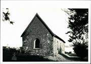
The place has aesthetic value as a stone & brick church in the Victorian Gothic style with an associated cemetery located in a picturesque rural setting.
The place has associations with the development of Culham and in particular with the local Anglican Parish from 1850s up to the present day.
The place has associations with pioneers of the Culham area, the Phillips, who donated the land towards the construction of the church and were highly influential in its construction.
The place is believed to be the second oldest still operating Anglican Church in WA.
The place is one of only a few extant churches dating from the 1850s in the Wheatbelt area.
The place comprises a church, cemetery, wc, front entry gate and fence, and plantings such as pencil pines. The church is of stone construction (1852) with brick gable infills (1857) and a steep CGI clad roof. There are brick quoins to openings, including the arched leadlight windows, and the building has a separate rendered front porch. Steel braces have been installed on the south-east side of the building. The cemetery has headstones and railings.
In 1847, the Church of England constituted a new diocese of South Australia which included all of Western Australia until 1856. In 1849, Bishop Augustus Short, the first Bishop of Adelaide, visited his brother in law SP Phillips at Culham, and recognisiong the need for a church Phillips donated 12 acres of land for the purpose, and started a building fund. In 1850, the timber was cut, and by 1852, the stone walls had been constructed, and the building was roofed with flat sheets of iron. (shipments of sheet iron were available in Perth from late 1840s). The first service was held in April 1853, even though the church wasn’t finished, and in November 1854, Simon Martin and Emily Doust were married in the church even though it was in a bad state of repair. The Phillips family departed for England, and the church fell into disrepair. When the Phillips returned, work was resumed, and the church opened on 19 July 1857, and was celebrated with a dinner at the Culham homestead that evening. Although a Bishop of Perth had been consecrated in 1856, St Phillip’s was not consecrated until September 1895, when the Right reverend GOL Riley, the 3rd Bishop and 1st Archbishop traveled to Culham. Special permission is required to be buried in Culham Cemetery; a person must be a descendant of someone already interred. The church is the second oldest active Anglican church in Western Australia, (Oldest is St John’s in Albany) and still a cemetery. The church is still an active worship centre with monthly services and special services at Christmas, Easter and Harvest.
High
Sound
| Library Id | Title | Medium | Year Of Publication |
|---|---|---|---|
| 7915 | Toodyay homesteads: past and present. | Book | 2006 |
Individual Building or Group
| Epoch | General | Specific |
|---|---|---|
| Present Use | RELIGIOUS | Church, Cathedral or Chapel |
| Original Use | RELIGIOUS | Church, Cathedral or Chapel |
| Style |
|---|
| Victorian Free Gothic |
| Type | General | Specific |
|---|---|---|
| Wall | STONE | Other Stone |
| Roof | METAL | Corrugated Iron |
| General | Specific |
|---|---|
| SOCIAL & CIVIC ACTIVITIES | Religion |
This information is provided voluntarily as a public service. The information provided is made available in good faith and is derived from sources believed to be reliable and accurate. However, the information is provided solely on the basis that readers will be responsible for making their own assessment of the matters discussed herein and are advised to verify all relevant representations, statements and information.
Constructed from 1852, Constructed from 1947
The place has historic value as the first Anglican Church in Toodyay district and for the continuing use of the cemetery. The place has historic value for its associations with significant church dignitaries and the Philips family in Culham. It is the second oldest active Anglican Church in Western Australia. The church has social value for its role in the community and its sense of place for generations of people who have worshipped and had special events and celebrations in the church. The place has aesthetic value for its simple and classic design and use of local materials and its contribution to the townscape.
Stone, brick and iron construction, steeply pitched roof with brick gables, pointed arch windows with brick dressings and leaded timber framed casement windows. Rendered porch with steeply pitched roof. Brickwork in gables laid in English garden wall bond. Adjoining cemetery within bush setting. Stabilisation works are propping the rear elevation up.
In 1847 the Church of England constituted a new diocese of South Australia which included all of Western Australia until 1856. In 1849 Bishop Augustus Short, the first Bishop of Adelaide, visited his brother-in-law SP Phillips at culham and, recognising the need for a church, Phillips donated 12 acres of land and started a building fund. In 1850, the timber was cut and by 1852 the stone walls had been constructed (by George Henry Hasell) and the building was roofed with flat sheets of iron. The first service was held in April 1853, despite the church building not being completed. The Phillips family departed for England and the church fell into disrepair. When the Phillips' returned, work was resumed and the church opened on 19 July 1857. St Phillip's was consecrated in September 1895 when Right Reverend GOL Riley, the third Bishop and first Archbishop, travelled to Culham. The church is the second oldest active Anglican church in Western Australia and is still an active cemetery (although there are special conditions to being buried there).
Integrity: High Authenticity: High
Poor-Fair
| Owner | Category |
|---|---|
| Perth Diocesan Trustees | Church Property |
This information is provided voluntarily as a public service. The information provided is made available in good faith and is derived from sources believed to be reliable and accurate. However, the information is provided solely on the basis that readers will be responsible for making their own assessment of the matters discussed herein and are advised to verify all relevant representations, statements and information.
1910 Toodyay-Bindi Bindi Rd Culham
GPS: 0452840 6524947
Cowardine
Toodyay
Avon Arc
Constructed from 1895
| Type | Status | Date | Documents |
|---|---|---|---|
| Heritage List | Adopted | 01 Dec 2012 |
| Type | Status | Date | Documents |
|---|---|---|---|
| (no listings) |
| Type | Status | Date | Grading/Management | |
|---|---|---|---|---|
| Category | ||||
| Municipal Inventory | Adopted | 27 Aug 1998 | Category 3 | |
| Library Id | Title | Medium | Year Of Publication |
|---|---|---|---|
| 7915 | Toodyay homesteads: past and present. | Book | 2006 |
Individual Building or Group
| Epoch | General | Specific |
|---|---|---|
| Present Use | RESIDENTIAL | Single storey residence |
| Original Use | RESIDENTIAL | Single storey residence |
| Style |
|---|
| Federation Bungalow |
| Type | General | Specific |
|---|---|---|
| Roof | TILE | Ceramic Tile |
| Wall | BRICK | Common Brick |
| General | Specific |
|---|---|
| DEMOGRAPHIC SETTLEMENT & MOBILITY | Settlements |
This information is provided voluntarily as a public service. The information provided is made available in good faith and is derived from sources believed to be reliable and accurate. However, the information is provided solely on the basis that readers will be responsible for making their own assessment of the matters discussed herein and are advised to verify all relevant representations, statements and information.
Constructed from 1905, Constructed from 1950
The place has historic value for its association with early settlers in the district, the Hamersley family. The place has aesthetic value as a good example of a substantial residence built in the 1890's and extended in 1908 and the homestead complex demonstrates the development of the property from the 19th century to the present day.
Single storey bungalow much altered in the 1950's removing much of its original character and its features. Red brick construction with tuck pointing, mixture of window styles which are representative of their development era. The roof is hipped with vented gablets and dormers overlooking the formal English garden. Dominant red brick gable supported on brick piers forming the roof over the front verandah space. Mix of window styles: casement windows are flush with the eaves and are of horizontal emphasis, the timber sash windows are lower down than the facades and are of vertical emphasis.
'Haseley' was owned by S.P. Phillips and Edward Hamersley. It was originally lease to Walter Padbury and was known as the 'Cowardine'. It was used to fatten cattle and stockmen lived in a hut with only a few acres cleared. 'Coawrdine' was bequeathed to Edward Hamersley's son, Samuel. In 1891 the last stockman, Patrick Hennessey, was replaced by Samuel Hamersley's son Vernon who cleared large areas for cropping. Vernon Hamersley married Clara Hicks in 1895, built a modern brick house and renamed the property 'Haseley'. Vernon established his own stud flock. He became President of the Merino Stud Sheep Breeders Association and the annual sales held at 'Haseley' attracted keen buyers. The homestead was enlarged in 1908. Vernon Hamersley died in 1946 and his son Preston carried on the farm until his death.
Integrity: Medium Authenticity: Low
Fair
| Owner | Category |
|---|---|
| Hamersley Nominees | Other Private |
This information is provided voluntarily as a public service. The information provided is made available in good faith and is derived from sources believed to be reliable and accurate. However, the information is provided solely on the basis that readers will be responsible for making their own assessment of the matters discussed herein and are advised to verify all relevant representations, statements and information.
Dumbarton Rd Dumbarton
Ninego Property,
Toodyay
Avon Arc
| Type | Status | Date | Documents |
|---|---|---|---|
| Heritage List | Adopted | 01 Dec 2012 |
| Type | Status | Date | Documents |
|---|---|---|---|
| (no listings) |
| Type | Status | Date | Grading/Management | |
|---|---|---|---|---|
| Category | ||||
| Municipal Inventory | Adopted | 11 Jan 2013 | Category 1 | |
Geological monument
| Epoch | General | Specific |
|---|---|---|
| Original Use | OTHER | Other |
| Type | General | Specific |
|---|---|---|
| Other | STONE | Granite |
This information is provided voluntarily as a public service. The information provided is made available in good faith and is derived from sources believed to be reliable and accurate. However, the information is provided solely on the basis that readers will be responsible for making their own assessment of the matters discussed herein and are advised to verify all relevant representations, statements and information.
Constructed from 1849
Shepherd’s Rock is a large naturally occurring granite rock formation that was carved with an inscription in 1849 by local shepherd Richard Kirby. The rock has cultural heritage significance for the following reasons: Shepherd’s rock has historic value as a rare possibly unique specimen of carving by a shepherd in a rural setting. The carved rock has historic and social value as it is evidence of the pastoral industry which was significant to the establishment of the district. Shepherd’s rock has historic value as it is associated with the Parkhurst boys who were transported to the Swan River Colony prior to the introduction of convicts.
The large granite rock is located in the shallow valley of a watercourse. Large mature trees are present close to a narrow stream. The surrounding land is open pasture and sheep were grazing in the paddock in which Shepherd’s Rock is located. The rock is approximately 3 metres high and 3 metres wide at the base. The rock is roughly half of an oval in shape and the carving is located on the face which is oriented toward the stream. The carving ‘A.D. 1849 R. KIRBY’ following these letters are two symbols, a shepherd’s crook and a bottle. The carving is obscured by lichen growing on the surface of the rock but does not appear to be penetrating the surface and changing the form of the carving. The property continues to be used for sheep farming and presumably has changed little since the period in which the carving took place.
The owner of the property in 1849 was James B Sinclair (1815‐1898) who had arrived in 1840 from Scotland with his wife and son. He was indentured to Lionel Lukin and in 1842 was working as a shepherd at ‘Dumbarton’. He purchased ‘Dumbarton’ in 1845 for £246 and became a prominent member of the community as a pastoralist, farmer and innkeeper. He contributed to the community through positions in the Toodyay Agricultural Society, the Board of Education and the Toodyay Roads Board. He employed many ticket‐of‐leave men on his property including Richard Kirby. Kirby (1830‐1896) was a Parkhurst boy arrived in the colony in 1849 on the Ameer. The Parkhurst boys were juvenile offenders from the Isle of Wight's Parkhurst Prison, who were transported to the Australian and New Zealand colonies between 1842 and 1861. Under the scheme, the boys were to be granted pardons under certain conditions such as permanent exile from England and, in the case of younger boys, undertaking apprenticeship in the colonies. 1,499 boys are recorded as being sent to the colonies where, particularly in New Zealand, the scheme was seen by some as de facto convictism. In Western Australia, however, the need for labour at that time appears to have made the young exiles acceptable Kirby was employed by Sinclair at Dumbarton as a shepherd and did the carving whilst fulfilling his duties on the property. Kirby was living in York in 1859 and in 1870 he employed 4 ticket‐of‐leave men. In c.1880 Kirby was working as a shepherd in Esperance. The symbols on the rock are of a crook and a bottle which represent the working life of the shepherd, the crook of the shepherd and a bottle of tobacco water for the treatment of scabs and sores on sheep.
Integrity: High Authenticity: High
Good
This information is provided voluntarily as a public service. The information provided is made available in good faith and is derived from sources believed to be reliable and accurate. However, the information is provided solely on the basis that readers will be responsible for making their own assessment of the matters discussed herein and are advised to verify all relevant representations, statements and information.
6 Extracts Pl Dumbarton
Toodyay
Avon Arc
Constructed from 1945
| Type | Status | Date | Documents |
|---|---|---|---|
| Heritage List | Adopted | 01 Dec 2012 |
| Type | Status | Date | Documents |
|---|---|---|---|
| (no listings) |
| Type | Status | Date | Grading/Management | |
|---|---|---|---|---|
| Category | ||||
| Municipal Inventory | Adopted | 27 Aug 1998 | Category 3 | |
| Name | Type | Year From | Year To |
|---|---|---|---|
| Association to | Architect | - | - |
Individual Building or Group
| Epoch | General | Specific |
|---|---|---|
| Present Use | FORESTRY | Other |
| Original Use | FORESTRY | Other |
| Type | General | Specific |
|---|---|---|
| Wall | METAL | Corrugated Iron |
| General | Specific |
|---|---|
| OCCUPATIONS | Timber industry |
This information is provided voluntarily as a public service. The information provided is made available in good faith and is derived from sources believed to be reliable and accurate. However, the information is provided solely on the basis that readers will be responsible for making their own assessment of the matters discussed herein and are advised to verify all relevant representations, statements and information.
Constructed from 1945
The place has social value through its associations with post war industry in Toodyay which provides significant employment. The place has aesthetic value as a demonstration of a post war industrial complex.
A range of metal sheds arranged with 'saw tooth' roof line in a poor state of repair and rusted but still functioning. High level blocked window openings. Single storey side extension of same construction style. Single storey office building adjacent to factory of weatherboard and iron construction with verandah.
This place was constructed in c.1950 to accommodate the new business endeavour, "Industrial Extracts Ltd". The business was established to produce a wood extract, used mainly in the leather tanning industry. The factory closed in 1971 as it became uneconomic. The factory provided significant employment for the district and was symptomatic of the post World War Two development of Toodyay. The buildings are still used for industrial purposes.
Integrity: Medium-High Authenticity: Medium
Poor
This information is provided voluntarily as a public service. The information provided is made available in good faith and is derived from sources believed to be reliable and accurate. However, the information is provided solely on the basis that readers will be responsible for making their own assessment of the matters discussed herein and are advised to verify all relevant representations, statements and information.
326 Goomalling - Toodyay Rd Dumbarton
GPS: 0453906 6511095 Shearer's Shed (on different lot) 0453524 6511125 MI States: 430 Goomalling-Toodyay Rd
Clarkson's
The Range
Toodyay
Avon Arc
Constructed from 1860
| Type | Status | Date | Documents |
|---|---|---|---|
| Heritage List | Adopted | 01 Dec 2012 |
| Type | Status | Date | Documents |
|---|---|---|---|
| RHP - To be assessed | Current | 27 Feb 2004 |
| Type | Status | Date | Grading/Management | |
|---|---|---|---|---|
| Category | ||||
| Municipal Inventory | Adopted | 27 Aug 1998 | Category 1 | |
The place has aesthetic value as a group of buildings of similar style and form located in a picturesque rural setting on the Avon River.
The place forms a cultural environment, being a homestead complex with outbuildings associated with the pastoral industry.
The place has associations with the settlement of the area, in particular with the development of the pastoral industry.
The place has associations with prominent pioneering families Andersons & the Clarkson's.
The place has rarity value for its billiard room building.
The place is representative of a pastoral homestead complex in the Wheatbelt region.
The place comprises a homestead residence, a billiard room, a kitchen, a cottage, and a shearers quarters & stone barn close to the main road. The buildings are all single storey of brick construction with garden wall bond brickwork. The homestead has a hipped cgi roof and a separate roof over the surrounding verandah. The exceptions to this are the stone shearing quarters which has brick quoins to openings and a skillion roof, and the stone barn which has a gable cgi roof.
‘Alexander Anderson’s original grant in 1832, in the Avon Valley changed to ‘Mt Anderson’ in 1836. Some members of his large family went on to Van Dieman’s land, but he stayed to organize his grants, before going in 1837, leaving neighbor, James Drummond Jnr, as agent for the place. Michael Clarkson was one of the Peninsula Farm ‘Tranby’ folks, later he leased ‘Wilberforce’ in York until 1839, before staying with his in-law's the Drummonds. After struggling, he took on a small farm ‘Nunyle’, but gave up farming in 1848. In 1854, Mt Anderson was divided up. In 1857, Michael Clarkson leased portion U3 of Mt Anderson. By 1892, Narnard Drummond Clarkson owned ‘Mt Anderson’ and was proud that it was self-supporting. In 1907 BD Clarkson died. In 1909, Mt Anderson was divided between BD’s sons, and was renamed; Yandee (DD Clarkson), Foggarthorpe (BL Clarkson) and The Range (HW Clarkson). Each of the sons already had vast properties in the Bolgart area.’
Integrity- Moderate Authenticity- High
Fair
| Library Id | Title | Medium | Year Of Publication |
|---|---|---|---|
| 7915 | Toodyay homesteads: past and present. | Book | 2006 |
Individual Building or Group
| Epoch | General | Specific |
|---|---|---|
| Other Use | FARMING\PASTORAL | Servants or Shearers Quarters |
| Present Use | FARMING\PASTORAL | Homestead |
| Other Use | FARMING\PASTORAL | Kitchen |
| Original Use | FARMING\PASTORAL | Homestead |
| Style |
|---|
| Victorian Georgian |
| Vernacular |
| Type | General | Specific |
|---|---|---|
| Roof | METAL | Corrugated Iron |
| Wall | BRICK | Common Brick |
| General | Specific |
|---|---|
| OCCUPATIONS | Grazing, pastoralism & dairying |
This information is provided voluntarily as a public service. The information provided is made available in good faith and is derived from sources believed to be reliable and accurate. However, the information is provided solely on the basis that readers will be responsible for making their own assessment of the matters discussed herein and are advised to verify all relevant representations, statements and information.
Constructed from 1860
The place has aesthetic value as a substantial group of buildings which are uncommon remaining example of a farm complex developed in the later half of the 19th century in the Toodyay area. The place demonstrates a high degree of authenticity and integrity. The place has historic value for its associations with Mt Anderson, the Andersons and the Clarkson family. The place is a landmark on the Goomalling-Toodyay Road.
Single storey brick dwelling with cellars, iron roof and verandahs. The main roof has a hipped roof, whilst the ancillary buildings have a combination of gabled and hipped roofs. The two sections are connected by a covered walkway. The house sits upon a stone plinth. Floor to ceiling timber framed sash windows. Open verandah around much of the property. Prominent chimneys. Partial Cellar. The cottage comprises two simple rectangular former barns, joined by a skillion roofed brick section incorporating a high level timber framed casement windows. Two pitched gabled roofs to main buildings. Red brick chimney. Verandah to the rear. brickwork laid in English Garden Wall bond.
Alexander Anderson's grant of 1832 in the Avon Valley was changed to 'Mt Anderson' in 1836. Some members of his large family went to Tasmania while he stayed to organise his grants before leaving his neighbour James Drummond Jnr. as agent for the land in 1837. James and later owners offered small areas of land free from rental to men who were prepared to clear and farm them. When James Drummond died in 1873, Daniel Connor bought 'Mt Anderson' and Barnard Clarkson (James' Son) secured a fourteen year lease. In 1885 Barnard Clarkson mortgaged the property and subdivided 40 acres into 100 town lots to be named North Newcastle Suburb. Many of these lots were bought by local people and Clarkson also lent some of the land for a cricket ground and football matches. Clarkson eventually cleared the mortgage for 'Mt Anderson' in 1907, just two years prior to his death in 1909. His properties were divided between his sons, Henry Wilberforce Clarkson became the owner of 'Mt Anderson' and renamed it 'The Range'.
Integrity: High Authenticity: High
Generally Good
| Owner | Category |
|---|---|
| Mackay | Other Private |
This information is provided voluntarily as a public service. The information provided is made available in good faith and is derived from sources believed to be reliable and accurate. However, the information is provided solely on the basis that readers will be responsible for making their own assessment of the matters discussed herein and are advised to verify all relevant representations, statements and information.
76 Goomalling-Toodyay Rd Dumbarton
Whitfields, part of original Wicklow Hills
Toodyay
Avon Arc
Constructed from 1890
| Type | Status | Date | Documents |
|---|---|---|---|
| Heritage List | Adopted | 01 Dec 2012 |
| Type | Status | Date | Documents |
|---|---|---|---|
| (no listings) |
| Type | Status | Date | Grading/Management | |
|---|---|---|---|---|
| Category | ||||
| Municipal Inventory | Adopted | 27 Aug 1998 | Category 3 | |
Historic site
| Epoch | General | Specific |
|---|---|---|
| Other Use | RESIDENTIAL | Other |
| Original Use | RESIDENTIAL | Single storey residence |
| Present Use | RESIDENTIAL | Single storey residence |
| Style |
|---|
| Victorian Georgian |
| Type | General | Specific |
|---|---|---|
| Wall | EARTH | Adobe {Mud Brick} |
| General | Specific |
|---|---|
| DEMOGRAPHIC SETTLEMENT & MOBILITY | Settlements |
This information is provided voluntarily as a public service. The information provided is made available in good faith and is derived from sources believed to be reliable and accurate. However, the information is provided solely on the basis that readers will be responsible for making their own assessment of the matters discussed herein and are advised to verify all relevant representations, statements and information.
Constructed from 1890
The place has historic value for its associations with the Whitfield and Connor families. The site has research value as it has potential to contain subsurface archaeological remains. The place has some aesthetic value for the information it may reveal relating to former practices and materials.
The remains of a mudbrick, stone and red brick house are evident. No roof cover but some roof timbers remain in situ. Stone dressings to doors and windows and there is a partial cellar. The mudbrick was rendered but the majority has fallen off. There is evidence of it being scored to look like ashlar. Some of the rear elevation has collapsed. Some of the timber flooring remains. Red brick extensions to the rear.
This place was part of the original crown grant to Captain Whitfield soon after his arrival in the colony in 1830. The original cottage in the property was constructed soon after he settled in 1839. In 1856 Whitfield divided the 5000 acres into two sections giving one half to his son, Francis, and the other to George Munro. Francis called his property 'Wicklow Hills' and George retained the name 'Knockdomony'. Daniel Connor bought 'Wicklow Hills' and left it to his son Barnard Maurice Connor in 1898. in 1934 B.M. Connor died and left the place to his nephew Edward Hayes who later returned to 'Wicklow Hills' in 1943 after being wounded during the war.
Integrity: Low Authenticity: Low
Ruins
| Owner | Category |
|---|---|
| Guest Nominees | Other Private |
This information is provided voluntarily as a public service. The information provided is made available in good faith and is derived from sources believed to be reliable and accurate. However, the information is provided solely on the basis that readers will be responsible for making their own assessment of the matters discussed herein and are advised to verify all relevant representations, statements and information.
Northam Toodyay Road Dumbarton
Northam Toodyay Road
Toodyay
Avon Arc
| Type | Status | Date | Documents |
|---|---|---|---|
| (no listings) |
| Type | Status | Date | Documents |
|---|---|---|---|
| RHP - Does not warrant assessment | Current | 30 Sep 2016 |
| Type | Status | Date | Grading/Management | |
|---|---|---|---|---|
| Category | ||||
| (no listings) | ||||
• The place is representative of the type of timber bridges constructed in the Wheatbelt during the 1940s and the subsequent ‘refurbishment’ of most of these in the latter part of the twentieth-century
• The place may represent the use of sustenance labour for bridge construction in the Wheatbelt in the 1940s
• The place may represent the work of local governments in road bridge construction in the Wheatbelt
Bridge 364, Koondinee Creek, Northam Toodyay Road, Dumbarton comprises a road bridge with a timber superstructure on concrete abutments. The bridge measures 7 metres in length, and 9 metres in overall width. The bridge was constructed in 1940 and a concrete overlay was applied in 1986. White-painted timber and iron guard rails line both sides.
Dumbarton is situated in the Wheatbelt region of Western Australia, approximately 3 kilometres east of the Town of Toodyay. The Wheatbelt region of Western Australia wraps around the north and east side of the metropolitan area, includes the Avon Valley, and extends from Jurien Bay in the northwest, Lake King in the southeast, and the Shire of Yilgarn in the east. The area is predominantly mixed farming, namely wheat and sheep. Agricultural settlement of the region began in the Avon Valley in 1831 and, although a route from Perth to Albany was surveyed in 1830 it remained a sand track in the 1840s. Toodyay (then Newcastle) was occupied by the British for agricultural purposes in 1836, albeit several kilometres downstream from the current location. Development was slow until, in 1850, the first shipload of convicts arrived in the Colony providing the needed labour force to undertake public works. In 1851 a convict depot was established at Toodyay, at the site where the town stands today, with the town relocating there in 1859. In 1884/5 the railway from Guildford to York was completed, and the line to Toodyay in 1888. By the 1880s the Moore and Avon River valleys comprised largely established wheat and sheep farmers. However, the remainder of the Wheatbelt saw mainly seasonal use with scattered isolated homesteads the norm. With the gold boom in the 1890s the Toodyay area prospered being near the route to the eastern goldfields and hence a source of provisions for those enroute to the goldfields. Agriculture diversified and in 1910 the name of the town was changed to Toodyay. Despite many men from the area leaving to join up in WWI the area continued to be successful in agricultural production. Post-WWI agricultural production continued to increase albeit suffering some setbacks during the Depression as seen elsewhere. Sustenance work is likely to have been undertaken in the area though which projects were specifically part of this program are not known at this time. Many of the smaller settlements in the area did not survive the Depression and in 1934 a major flood hit Toodyay with many roads and rail bridges impacted. According to the data held by Main Roads (Wheatbelt) Bridge 364, Koondinee Creek, Northam Toodyay Road, Dumbarton was constructed in 1940. Following WWII the region saw increased economic growth and stability and both the State and local governments invested in infrastructure. Toodyay was linked to the state electricity grid and scheme water during this period. The Road Board became the Shire of Toodyay in 1961. Toodyay did not reap a direct benefit from the mining boom of the 1960s and 1970s but in the 1960s tourism had begun to emerge as a subsidiary industry for the region. In the 1960s the railway was upgraded to standard gauge and the new Avon Valley line was opened and a new station constructed at Toodyay. The 1970s saw a decline in the rural economy but small ‘hobby farms’ became popular and tourism was further promoted to supplement the local economy.
Historic site
| Epoch | General | Specific |
|---|---|---|
| Present Use | Transport\Communications | Road: Bridge |
| Original Use | Transport\Communications | Road: Bridge |
| Type | General | Specific |
|---|---|---|
| Other | TIMBER | Other Timber |
| Other | METAL | Other Metal |
| Other | CONCRETE | Other Concrete |
This information is provided voluntarily as a public service. The information provided is made available in good faith and is derived from sources believed to be reliable and accurate. However, the information is provided solely on the basis that readers will be responsible for making their own assessment of the matters discussed herein and are advised to verify all relevant representations, statements and information.
Northam Toodyay Road Dumbarton
Northam Toodyay Road
Toodyay
Avon Arc
| Type | Status | Date | Documents |
|---|---|---|---|
| (no listings) |
| Type | Status | Date | Documents |
|---|---|---|---|
| RHP - Does not warrant assessment | Current | 30 Sep 2016 |
| Type | Status | Date | Grading/Management | |
|---|---|---|---|---|
| Category | ||||
| (no listings) | ||||
• The place is representative of the type of timber bridges constructed in the Wheatbelt during the 1940s.
• The place may represent the use of sustenance labour for bridge construction in the Wheatbelt in the 1940s
• The place may represent the work of local governments in road bridge construction in the Wheatbelt.
Bridge 365, Harper Brook, Northam-Toodyay Road, Dumbarton comprises a road bridge with a timber superstructure on concrete abutments. The bridge measures 7 metres in length, and approximately 9 metres in overall width. The bridge was constructed in 1940. White-painted timber and iron guard rails line both sides.
Dumbarton is situated in the Wheatbelt region of Western Australia, approximately 3 kilometres east of the Town of Toodyay. The Wheatbelt region of Western Australia wraps around the north and east side of the metropolitan area, includes the Avon Valley, and extends from Jurien Bay in the northwest, Lake King in the southeast, and the Shire of Yilgarn in the east. The area is predominantly mixed farming, namely wheat and sheep. Agricultural settlement of the region began in the Avon Valley in 1831 and, although a route from Perth to Albany was surveyed in 1830 it remained a sand track in the 1840s. Toodyay (then Newcastle) was occupied by the British for agricultural purposes in 1836, albeit several kilometres downstream from the current location. Development was slow until, in 1850, the first shipload of convicts arrived in the Colony providing the needed labour force to undertake public works. In 1851 a convict depot was established at Toodyay, at the site where the town stands today, with the town relocating there in 1859. In 1884/5 the railway from Guildford to York was completed, and the line to Toodyay in 1888. By the 1880s the Moore and Avon River valleys comprised largely established wheat and sheep farmers. However, the remainder of the Wheatbelt saw mainly seasonal use with scattered isolated homesteads the norm. With the gold boom in the 1890s the Toodyay area prospered being near the route to the eastern goldfields and hence a source of provisions for those enroute to the goldfields. Agriculture diversified and in 1910 the name of the town was changed to Toodyay. Despite many men from the area leaving to join up in WWI the area continued to be successful in agricultural production. Post-WWI agricultural production continued to increase albeit suffering some setbacks during the Depression as seen elsewhere. Sustenance work is likely to have been undertaken in the area though which projects were specifically part of this program are not known at this time. Many of the smaller settlements in the area did not survive the Depression and in 1934 a major flood hit Toodyay with many roads and rail bridges impacted. According to the data held by Main Roads (Wheatbelt) Bridge 365, Harper Brook, Northam-Toodyay Road, Dumbarton was constructed in 1940. Following WWII the region saw increased economic growth and stability and both the State and local governments invested in infrastructure. Toodyay was linked to the state electricity grid and scheme water during this period. The Road Board became the Shire of Toodyay in 1961. Toodyay did not reap a direct benefit from the mining boom of the 1960s and 1970s but in the 1960s tourism had begun to emerge as a subsidiary industry for the region. In the 1960s the railway was upgraded to standard gauge and the new Avon Valley line was opened and a new station constructed at Toodyay. The 1970s saw a decline in the rural economy but small ‘hobby farms’ became popular and tourism was further promoted to supplement the local economy.
Historic site
| Epoch | General | Specific |
|---|---|---|
| Present Use | Transport\Communications | Road: Bridge |
| Original Use | Transport\Communications | Road: Bridge |
| Type | General | Specific |
|---|---|---|
| Other | CONCRETE | Other Concrete |
| Other | TIMBER | Other Timber |
| Other | METAL | Other Metal |
This information is provided voluntarily as a public service. The information provided is made available in good faith and is derived from sources believed to be reliable and accurate. However, the information is provided solely on the basis that readers will be responsible for making their own assessment of the matters discussed herein and are advised to verify all relevant representations, statements and information.
1944-1956 Northam-Toodyay Rd Dumbarton
Toodyay
Avon Arc
Constructed from 1945
| Type | Status | Date | Documents |
|---|---|---|---|
| Heritage List | Adopted | 01 Dec 2012 |
| Type | Status | Date | Documents |
|---|---|---|---|
| (no listings) |
| Type | Status | Date | Grading/Management | |
|---|---|---|---|---|
| Category | ||||
| Municipal Inventory | Adopted | 27 Aug 1998 | Category 3 | |
Individual Building or Group
| Epoch | General | Specific |
|---|---|---|
| Original Use | FORESTRY | Housing or Quarters |
| Present Use | RESIDENTIAL | Single storey residence |
| Type | General | Specific |
|---|---|---|
| Roof | TILE | Ceramic Tile |
| Wall | ASBESTOS | Fibrous Cement, flat |
| General | Specific |
|---|---|
| OCCUPATIONS | Timber industry |
This information is provided voluntarily as a public service. The information provided is made available in good faith and is derived from sources believed to be reliable and accurate. However, the information is provided solely on the basis that readers will be responsible for making their own assessment of the matters discussed herein and are advised to verify all relevant representations, statements and information.
Constructed from 1945
The place has social value through its associations with post war industry in Toodyay which provided significant employment to the district. The houses have social value as they demonstrate a former way of life for workers in the 1950's.
A group of seven dwellings that are asbestos clad, timber framed with red Marseille tile hipped roofs or corrugated iron roofs. The houses have front verandahs and a variety of window styles. Many alterations have been undertaken to the houses but collectively they still demonstrate an important cohesive group value.
These seven dwellings that were built for the managers and staff of the extracts factory which is located adjacent to the group of houses. "Industrial Extracts Ltd", was established in c.1950 to produce a wood extract, used mainly in the leather tanning industry. The factory closed in 1971 as it became uneconomic. The main factory buildings are still on the site.
Integrity: High Authenticity: Medium
Fair
This information is provided voluntarily as a public service. The information provided is made available in good faith and is derived from sources believed to be reliable and accurate. However, the information is provided solely on the basis that readers will be responsible for making their own assessment of the matters discussed herein and are advised to verify all relevant representations, statements and information.
2027 Northam-Toodyay Rd Dumbarton
Toodyay
Avon Arc
Constructed from 1890
| Type | Status | Date | Documents |
|---|---|---|---|
| Heritage List | Adopted | 01 Dec 2012 |
| Type | Status | Date | Documents |
|---|---|---|---|
| (no listings) |
| Type | Status | Date | Grading/Management | |
|---|---|---|---|---|
| Category | ||||
| Municipal Inventory | Adopted | 27 Aug 1998 | Category 2 | |
| Library Id | Title | Medium | Year Of Publication |
|---|---|---|---|
| 7915 | Toodyay homesteads: past and present. | Book | 2006 |
Individual Building or Group
| Epoch | General | Specific |
|---|---|---|
| Present Use | RESIDENTIAL | Single storey residence |
| Original Use | RESIDENTIAL | Single storey residence |
| Style |
|---|
| Victorian Georgian |
| Type | General | Specific |
|---|---|---|
| Roof | METAL | Corrugated Iron |
| Wall | BRICK | Common Brick |
| General | Specific |
|---|---|
| DEMOGRAPHIC SETTLEMENT & MOBILITY | Settlements |
This information is provided voluntarily as a public service. The information provided is made available in good faith and is derived from sources believed to be reliable and accurate. However, the information is provided solely on the basis that readers will be responsible for making their own assessment of the matters discussed herein and are advised to verify all relevant representations, statements and information.
Constructed from 1894
The place has historic value for its associations with the Lloyd family as well as Rev. Charles Harper. The place has aesthetic value for its contribution to the streetscape of the town of Toodyay.
Single storey brick and iron symmetrical cottage with a deep open verandah to three sides. The brickwork is of stretcher-bond and windows are timber framed sash style. A cellar is located at the rear of the property. later additions of asbestos and weatherboard have not impacted on the form of the building. The dwelling has a new corrugated zincalume roof c.2008 and solar panels c.2009. A timber shearing shed located to the rear of the property is in poor condition although much of the original fabric is still in place.
In 1832 the Nardie grants were taken up by James Lloyd, the proprietor of the 'Star and Garter' in Fremantle. Charles Harper took the lease for the property between 1840 to 1855. He was to become Reverend Charles Harper, the first man to be ordained by the Anglican Church in the colony and the Minister in Toodyay from 1849. James Lloyd's widow and two sons, Charles and Joseph, returned to the property after Harper's lease expired and divided the property between them. James named his section 'Calbaline' and Joseph had 'Nardie'. The 1857 the first dwelling at Nardie was a mudbrick and shingle cottage which was replaced by the brick house c.1900. Built by Morris Lloyd (Joseph's eldest son) a builder who had worked in Victoria, Tasmania and New Zealand the house has many rooms and a spacious verandah.
Integrity: High Authenticity: Medium
Good
| Owner | Category |
|---|---|
| McLeod | Other Private |
This information is provided voluntarily as a public service. The information provided is made available in good faith and is derived from sources believed to be reliable and accurate. However, the information is provided solely on the basis that readers will be responsible for making their own assessment of the matters discussed herein and are advised to verify all relevant representations, statements and information.
Windmill Hill Dumbarton
5km from townsite GPS: 0454095 6506502
Toodyay
Avon Arc
Constructed from 1963 to 1964
| Type | Status | Date | Documents |
|---|---|---|---|
| Heritage List | Adopted | 01 Dec 2012 |
| Type | Status | Date | Documents |
|---|---|---|---|
| (no listings) |
| Type | Status | Date | Grading/Management | |
|---|---|---|---|---|
| Category | ||||
| Municipal Inventory | Adopted | 27 Aug 1998 | Category 2 | |
| Register of the National Estate | Indicative Place | |||
| Classified by the National Trust | Classified {Lscpe} | 20 Dec 1991 | ||
| Library Id | Title | Medium | Year Of Publication |
|---|---|---|---|
| 2314 | Windmill Hill Railway Cutting : nomination of a geological monument for the register of the National Estate. | Book | 1991 |
Geological monument
| Epoch | General | Specific |
|---|---|---|
| Original Use | Transport\Communications | Rail: Other |
| Present Use | Transport\Communications | Rail: Other |
| General | Specific |
|---|---|
| SOCIAL & CIVIC ACTIVITIES | Education & science |
| DEMOGRAPHIC SETTLEMENT & MOBILITY | Exploration & surveying |
| TRANSPORT & COMMUNICATIONS | Rail & light rail transport |
This information is provided voluntarily as a public service. The information provided is made available in good faith and is derived from sources believed to be reliable and accurate. However, the information is provided solely on the basis that readers will be responsible for making their own assessment of the matters discussed herein and are advised to verify all relevant representations, statements and information.
Constructed from 1964, Constructed from 1963
The place has historic value for its associations with the implementation of the standard gauge railway in Western Australia. The place has historic value as an example of an engineering challenge and achievements undertaken by Western Australian professionals. The place has aesthetic value as an illustration of how dramatically the physical environment has been shaped to accommodate new technologies.
A cutting through rock creating a narrow gorge with very steep embankments.
This is the deepest cut on the standard gauge railway. At the time of its construction it was the deepest cut in the Southern Hemisphere. it is still one of the deepest cuts constructed by Westrail.
Integrity: High Authenticity: High
Good
| Owner | Category |
|---|---|
| Public transport Authority | State Gov't |
This information is provided voluntarily as a public service. The information provided is made available in good faith and is derived from sources believed to be reliable and accurate. However, the information is provided solely on the basis that readers will be responsible for making their own assessment of the matters discussed herein and are advised to verify all relevant representations, statements and information.
925 Clackline-Toodyay Rd Hoddys Well
GPS: 0450775 6499174
Chrimes Cottage
Toodyay
Avon Arc
Constructed from 1936, Constructed from 1888
| Type | Status | Date | Documents |
|---|---|---|---|
| Heritage List | Adopted | 01 Dec 2012 |
| Type | Status | Date | Documents |
|---|---|---|---|
| (no listings) |
| Type | Status | Date | Grading/Management | |
|---|---|---|---|---|
| Category | ||||
| Classified by the National Trust | Classified | 14 Oct 1996 | ||
| Municipal Inventory | Adopted | 27 Aug 1998 | Category 3 | |
Individual Building or Group
| Epoch | General | Specific |
|---|---|---|
| Other Use | VACANT\UNUSED | Vacant\Unused |
| Present Use | Transport\Communications | Rail: Water Tower |
| Original Use | RESIDENTIAL | Single storey residence |
| Type | General | Specific |
|---|---|---|
| Roof | METAL | Corrugated Iron |
| Wall | EARTH | Adobe {Mud Brick} |
| Other | RENDER | Other Render |
| General | Specific |
|---|---|
| TRANSPORT & COMMUNICATIONS | Rail & light rail transport |
This information is provided voluntarily as a public service. The information provided is made available in good faith and is derived from sources believed to be reliable and accurate. However, the information is provided solely on the basis that readers will be responsible for making their own assessment of the matters discussed herein and are advised to verify all relevant representations, statements and information.
Constructed from 1888
The place has historic value for its association with early settler Lieutenant Frederick Slade, railway workers from the 1880's and the Chrimes family. The well is of historic value as a remnant from the expansion of the district in the 1880's when railway workers camped at the site. The site has research value as it has potential to contain subsurface archaeological remains.
The well was not inspected but advised that it is fenced out and covered with wooden planks, constructed of stone and in good condition. The house is a mudbrick rendered cottage with a replaced iron roof and surrounded by verandahs. Colonial style windows and a half hipped roof are present. The building is of a very simple style in a bushland setting.
This is part of Location X granted to H.G. Smith which was taken up by Lieutenant Frederick Slade after Smith died in 1841. He named the property 'Glenavon'. Slade appointed William Dodd as a policeman and leased him a small enclosure and house near 'Glenavon' where Dodd later conducted a store. By 1926 Mr masters, who owned 'Glenavon' sold a portion to Mr. Cutler. Hoddy's Well was used by railway construction workers when they established a camp at the site in 1886 and has been used by travellers for many years. The original cottage was abandoned after a flood. The existing cottage was built in about 1836 by Mr Chrimes.
Dwelling Integrity: Low-Medium Authenticity: Medium Well Integrity: High Authenticity: High
Good
| Owner | Category |
|---|---|
| Buckley | Other Private |
This information is provided voluntarily as a public service. The information provided is made available in good faith and is derived from sources believed to be reliable and accurate. However, the information is provided solely on the basis that readers will be responsible for making their own assessment of the matters discussed herein and are advised to verify all relevant representations, statements and information.
5914 Toodyay Rd Hoddys Well
Toodyay
Avon Arc
Constructed from 1893, Constructed from 1886
| Type | Status | Date | Documents |
|---|---|---|---|
| Heritage List | Adopted | 01 Dec 2012 |
| Type | Status | Date | Documents |
|---|---|---|---|
| (no listings) |
| Type | Status | Date | Grading/Management | |
|---|---|---|---|---|
| Category | ||||
| Municipal Inventory | Adopted | 27 Aug 1998 | Category 2 | |
Individual Building or Group
| Epoch | General | Specific |
|---|---|---|
| Present Use | INDUSTRIAL\MANUFACTURING | Winery |
| Original Use | INDUSTRIAL\MANUFACTURING | Winery |
| Style |
|---|
| Victorian Georgian |
| Type | General | Specific |
|---|---|---|
| Roof | METAL | Corrugated Iron |
| Wall | BRICK | Common Brick |
| General | Specific |
|---|---|
| OCCUPATIONS | Manufacturing & processing |
This information is provided voluntarily as a public service. The information provided is made available in good faith and is derived from sources believed to be reliable and accurate. However, the information is provided solely on the basis that readers will be responsible for making their own assessment of the matters discussed herein and are advised to verify all relevant representations, statements and information.
Constructed from 1886
The place has historic value as it is associated with the establishment and development of major vineyards and wineries in the Avon Valley. The place has historic value for its associations with Timothy Quinlan and the Wood family. The place has aesthetic value for its original construction methods and materials.
Red brick and stone structure. Two storey building with cellars of stone, a simple open verandah and hipped and gabled corrugated iron roof. Timber casement windows with stone dressings to cellar windows and all openings are set with rounded brick arches. The louvred openings maintain the symmetrical layout of the openings on the main range of the winery. The adjoining storage barn is a double height brick structure with iron hipped roof. Louvred openings and the double barn doors are the only features on the main façade. High level door opening and four small windows to side elevation. Brickwork laid in English Garden Wall bond. Iron extension to the rear of the winery. The symmetrical façade of the main entrance has centrally placed double doors flanked by small-paned casement windows and a stained glass window above the door incorporating 'Coorinja Winery' into the design. All the openings are set within stained timber surrounds. Internally some original barrels are still being used. Steel beams were shipped from Oregon, USA.
This property was purchased by Timothy Francis Quinlan, son-in-law of Daniel Connor and protege of B.D. Clarkson. Quinlan has worked for local business man J.H. Monger before expanding his business interests into property and entering politics. The winery was built in 1886 and extended in 1893. The first pruning competition in the district was held at Coorinja vineyard. In 1919 W.T. Wood purchased the property. The property is believed to be one of the last remaining wineries in the district which was established in the 19th century.
Integrity: Medium Authenticity: High
Fair
| Owner | Category |
|---|---|
| Wood | Other Private |
This information is provided voluntarily as a public service. The information provided is made available in good faith and is derived from sources believed to be reliable and accurate. However, the information is provided solely on the basis that readers will be responsible for making their own assessment of the matters discussed herein and are advised to verify all relevant representations, statements and information.
Toodyay-Clackline Rd Hoddy's Well Toodyay
6kms south of Toodyay on the Clackline Road GPS: 0449865 6503281
Ringa-Ringa Creek & Clackline-Toodyay Road
Toodyay
Avon Arc
Constructed from 1888, Constructed from 1950
| Type | Status | Date | Documents |
|---|---|---|---|
| Heritage List | Adopted | 01 Dec 2012 |
| Type | Status | Date | Documents |
|---|---|---|---|
| RHP - Does not warrant assessment | Current | 08 Dec 2023 |
| Type | Status | Date | Grading/Management | |
|---|---|---|---|---|
| Category | ||||
| Classified by the National Trust | Classified | 10 Aug 1998 | ||
| Statewide Lge Timber Str Survey | Completed | 11 Dec 1998 | ||
| Statewide Railway Heritage Surve | Completed | 01 Mar 1994 | ||
| Municipal Inventory | Adopted | 27 Aug 1998 | Category 2 | |
03858 Clackline to Toodyay Railway Formation (1888)
| Library Id | Title | Medium | Year Of Publication |
|---|---|---|---|
| 5021 | Ringa Bridge, Toodyay, WA : conservation plan. December 2000. | Heritage Study {Cons'n Plan} | 2000 |
| 6876 | Toodyay-Clackline heritage trail : management plan. | Report | 1998 |
Historic site
| Epoch | General | Specific |
|---|---|---|
| Original Use | Transport\Communications | Rail: Other |
| Present Use | Transport\Communications | Rail: Other |
| Type | General | Specific |
|---|---|---|
| Other | TIMBER | Other Timber |
| General | Specific |
|---|---|
| TRANSPORT & COMMUNICATIONS | Rail & light rail transport |
This information is provided voluntarily as a public service. The information provided is made available in good faith and is derived from sources believed to be reliable and accurate. However, the information is provided solely on the basis that readers will be responsible for making their own assessment of the matters discussed herein and are advised to verify all relevant representations, statements and information.
Constructed from 1889
The bridge has historic value for its association with the Clackline-Toodyay railway, a major infrastructure project which enabled the further development of agriculture in the district. The place has aesthetic value as a representative example of a timber bridge in good condition from the period. The site has research value as it has potential to contain subsurface archaeological remains.
Built as a timber trestle structure c.1887 was upgraded in the 1950's. 18 span, steep ramps on either side, steel beams have been incorporated into the structure. A plaque commemorating the centenary of the railway can be found at Coorinja Winery.
The bridge was built to carry the railway over the road which existed between Perth and Toodyay. It was part of the construction of the Clackline to Toodyay railway in 1888. The Ringa Siding was located on the east end of the bridge.
Integrity: Medium Authenticity: Medium
Good
| Owner | Category |
|---|---|
| Shire of Toodyay | Local Gov't |
This information is provided voluntarily as a public service. The information provided is made available in good faith and is derived from sources believed to be reliable and accurate. However, the information is provided solely on the basis that readers will be responsible for making their own assessment of the matters discussed herein and are advised to verify all relevant representations, statements and information.
Cobbler Pool Rd Jimperding
GPS: 0439073 6506372
Toodyay
Avon Arc
| Type | Status | Date | Documents |
|---|---|---|---|
| Heritage List | Adopted | 01 Dec 2012 |
| Type | Status | Date | Documents |
|---|---|---|---|
| (no listings) |
| Type | Status | Date | Grading/Management | |
|---|---|---|---|---|
| Category | ||||
| Municipal Inventory | Adopted | 27 Aug 1998 | Category 2 | |
Historic Site
| Epoch | General | Specific |
|---|---|---|
| Original Use | MONUMENT\CEMETERY | Cemetery |
| Present Use | MONUMENT\CEMETERY | Cemetery |
| General | Specific |
|---|---|
| DEMOGRAPHIC SETTLEMENT & MOBILITY | Settlements |
This information is provided voluntarily as a public service. The information provided is made available in good faith and is derived from sources believed to be reliable and accurate. However, the information is provided solely on the basis that readers will be responsible for making their own assessment of the matters discussed herein and are advised to verify all relevant representations, statements and information.
The cemetery has historic value as an illustration of the extent of settlement at Jimperding. The place has social value as a record of the early settlers in the district. The site has aesthetic value for the simple form of the headstones in the remote bushland setting.
A small cemetery in a bushland setting. It is fenced off and appears to be well maintained.
The cemetery is a record of the history of those who are buried there.
Integrity: High Authenticity: Medium
| Owner | Category |
|---|---|
| Department for Planning and Infrastructure | State Gov't |
This information is provided voluntarily as a public service. The information provided is made available in good faith and is derived from sources believed to be reliable and accurate. However, the information is provided solely on the basis that readers will be responsible for making their own assessment of the matters discussed herein and are advised to verify all relevant representations, statements and information.
Julimar Rd Julimar
Toodyay
Avon Arc
| Type | Status | Date | Documents |
|---|---|---|---|
| (no listings) |
| Type | Status | Date | Documents |
|---|---|---|---|
| (no listings) |
| Type | Status | Date | Grading/Management | |
|---|---|---|---|---|
| Category | ||||
| (no listings) | ||||
Individual Building or Group
| Epoch | General | Specific |
|---|---|---|
| Original Use | FARMING\PASTORAL | Cottage |
| Present Use | FARMING\PASTORAL | Cottage |
This information is provided voluntarily as a public service. The information provided is made available in good faith and is derived from sources believed to be reliable and accurate. However, the information is provided solely on the basis that readers will be responsible for making their own assessment of the matters discussed herein and are advised to verify all relevant representations, statements and information.
Chittering Rd Moondyne
Avon Valley national Park
Toodyay
Avon Arc
| Type | Status | Date | Documents |
|---|---|---|---|
| Heritage List | Adopted | 01 Dec 2012 |
| Type | Status | Date | Documents |
|---|---|---|---|
| (no listings) |
| Type | Status | Date | Grading/Management | |
|---|---|---|---|---|
| Category | ||||
| Municipal Inventory | Adopted | 11 Jan 2013 | Category 1 | |
Other Built Type
| Epoch | General | Specific |
|---|---|---|
| Original Use | OTHER | Other |
| Type | General | Specific |
|---|---|---|
| Other | STONE | Other Stone |
This information is provided voluntarily as a public service. The information provided is made available in good faith and is derived from sources believed to be reliable and accurate. However, the information is provided solely on the basis that readers will be responsible for making their own assessment of the matters discussed herein and are advised to verify all relevant representations, statements and information.
Constructed from 1878, Constructed from 1877
The Cairn has scientific value as it demonstrates the methods of early survey techniques of the 19th century. The place has historic value as it is associated with Sir John Forrest, explorer, surveyor and politician. It represents the first exploration and subsequent settlement of the Avon Valley in the Toodyay Shire and therefore has historic value.
The site lies amongst the undualting hills and gullies of the Avon Valley National Park on top of a hill. The site overlooks a watercourse (approx 500 m away) to the south and west. To the north is private property. Local geology is pisolithic conglomerate (coffee rock), orange, yellow and brown with isolated boulders/domes of granite in the surrounding areas. The site is located 115m south of the survey heritage trail and 3.2 km east of Plunkett Road. The Site is signposted and there are markers on the walk trail leading to the area. The place consists of a stone surveyor's cairn, approx 1.9m by 1.9m ub area, 1.2m high, composed of rocks arranged in a vaguely conical shape. The rocks themselves are composed of the same conglomerate coffee rock, on average 40cm in size. At the top/centre of the cairn is a pole of bush timber, approx 25 cm protrusing from the top of the rocks. The wood has been severely damaged by termites. However, the cairn as a whole appears stable with no signs of collapse of shifting.
The cairn is one of the markers constructed during a survey of the Swan and Avon Valleys by the Department of Lands and Surveys in 1877‐1878, designated ‘DP’. The triangulation survey team was led by John Forrest (1847‐1918) who was a significant figure in the historiy of Western Australia. He was influentital in the exploration of Western Australia as a surveyor and later moved into politics where he achieved the distinction of being the first Premier of Western Australia until his election in 1901 to the first Federal Government. Several survey markers or 'trig' points are located throughout the Swan and Avon Valleys and these now form part of the Avon Valley Survey Heritage trails opened in January 1996 in recognition of the pioneering achievements of Sir John Forrest. Theme: 105 ‐ Exploration
Integrity: High Authenticity: High
Good
This information is provided voluntarily as a public service. The information provided is made available in good faith and is derived from sources believed to be reliable and accurate. However, the information is provided solely on the basis that readers will be responsible for making their own assessment of the matters discussed herein and are advised to verify all relevant representations, statements and information.