Local Government
Toodyay
Region
Avon Arc
off Sapper Rd Moondyne
Avon Valley National Park
Toodyay
Avon Arc
| Type | Status | Date | Documents |
|---|---|---|---|
| Heritage List | Adopted | 01 Dec 2012 |
| Type | Status | Date | Documents |
|---|---|---|---|
| (no listings) |
| Type | Status | Date | Grading/Management | |
|---|---|---|---|---|
| Category | ||||
| Municipal Inventory | Adopted | Category 1 | ||
Individual Building or Group
| Epoch | General | Specific |
|---|---|---|
| Present Use | VACANT\UNUSED | Vacant\Unused |
| Original Use | FARMING\PASTORAL | Stockyard |
| Type | General | Specific |
|---|---|---|
| Other | TIMBER | Other Timber |
| General | Specific |
|---|---|
| OCCUPATIONS | Grazing, pastoralism & dairying |
This information is provided voluntarily as a public service. The information provided is made available in good faith and is derived from sources believed to be reliable and accurate. However, the information is provided solely on the basis that readers will be responsible for making their own assessment of the matters discussed herein and are advised to verify all relevant representations, statements and information.
Constructed from 1861, Constructed from 1855
The place has historic value as it is associated with Joseph Bolitho Johns (Moondyne Joe) who was a wellknown bushranger in the district.
Joe's Cage is located within the Avon Valley National Park in a landscape of native vegetation consisting of trees and shrubs. A rough path leads to the site from the access road. The bush timbers which formed the animal enclosures are in poor condition havingt been subject to termite attack and the elements. It is possible to determine the method of construction of the enclosure by the remaining posts with holes cut for the positioning of horizontal timbers. Some former horizontal bars of the structure are still evident leaning into the holes of the timber uprights, others are on the ground. In some cases it is difficult to determine if the timbers on the site are from the former structure or have been introduced to the site at a later date.
The cage was one of many constructed between 1855 and 1861 by pardoned convict turned outlaw Joseph Bolitho Johns (1827?‐1900), better known as Moondyne Joe' to capture wild horses and cattle as they came to drink at nearby springs in this remote and rugged valley. These structures originally measured 20m long by 10m wide and were hand built out of local timber. Joe lived in this valley in between prison terms served mainly for petty theft and escaping legal custody. His determination to be a free spirit and escape from prison earned Joe admiration from early settlers. John Forrest surveyed the site in 1878 during his survey along the Avon Valley from Walyunga to Toodyay.
Integrity: Low Authenticity: Low
Poor
This information is provided voluntarily as a public service. The information provided is made available in good faith and is derived from sources believed to be reliable and accurate. However, the information is provided solely on the basis that readers will be responsible for making their own assessment of the matters discussed herein and are advised to verify all relevant representations, statements and information.
Morangup
GPS: 0435289 6499874
Toodyay
Avon Arc
| Type | Status | Date | Documents |
|---|---|---|---|
| (no listings) |
| Type | Status | Date | Documents |
|---|---|---|---|
| (no listings) |
| Type | Status | Date | Grading/Management | |
|---|---|---|---|---|
| Category | ||||
| Municipal Inventory | Adopted | 27 Aug 1998 | Category 5 | |
Historic Site
| Epoch | General | Specific |
|---|---|---|
| Present Use | Transport\Communications | Water: Other |
| Original Use | Transport\Communications | Water: Other |
| General | Specific |
|---|---|
| DEMOGRAPHIC SETTLEMENT & MOBILITY | Settlements |
This information is provided voluntarily as a public service. The information provided is made available in good faith and is derived from sources believed to be reliable and accurate. However, the information is provided solely on the basis that readers will be responsible for making their own assessment of the matters discussed herein and are advised to verify all relevant representations, statements and information.
The site has historic value as it was a stopping place for travelling in the 1850's and 1860's and demonstrates the expansion of the district at this time. The site has research value as it has potential to contain subsurface archaeological remains.
There is no definitive evidence remaining but the approximate location was identified by the bank of trees.
One of the stopping places with a water supply for travellers was established by Fred Lee on ten acres that he took up in 1857. it was a day's journey to Toodyay where he worked as a carrier on the Guildford-Toodyay run. When the new road was constructed it bypassed Lee's place and eventually he abandoned it.
None
Site Only
| Owner | Category |
|---|---|
| Department of Environment & Conservation (Formerly CALM) | State Gov't |
This information is provided voluntarily as a public service. The information provided is made available in good faith and is derived from sources believed to be reliable and accurate. However, the information is provided solely on the basis that readers will be responsible for making their own assessment of the matters discussed herein and are advised to verify all relevant representations, statements and information.
Jingaling Brook Rd Morangup
GPS: 0438439 6502562
Jimperding Hill descent
Toodyay
Avon Arc
Constructed from 1852
| Type | Status | Date | Documents |
|---|---|---|---|
| Heritage List | Adopted | 01 Dec 2012 |
| Type | Status | Date | Documents |
|---|---|---|---|
| (no listings) |
| Type | Status | Date | Grading/Management | |
|---|---|---|---|---|
| Category | ||||
| Municipal Inventory | Adopted | 27 Aug 1998 | Category 2 | |
Historic Site
| Epoch | General | Specific |
|---|---|---|
| Original Use | MINING | Other |
| Present Use | MINING | Other |
| General | Specific |
|---|---|
| OCCUPATIONS | Mining {incl. mineral processing} |
This information is provided voluntarily as a public service. The information provided is made available in good faith and is derived from sources believed to be reliable and accurate. However, the information is provided solely on the basis that readers will be responsible for making their own assessment of the matters discussed herein and are advised to verify all relevant representations, statements and information.
Constructed from 1852
The site has historic value as a remnant of the gold mining industry in the district. The site has research value as it has potential to contain subsurface archaeological remains. The place has social value as a demonstration of former work practices in the mining industry.
Bush timbers entrance structure and mine construction still clearly evident although in dilapidated condition. The river has dried up the stepped constructions still exist.
Jimperding Hill descent is of geological interest. It was also an important road into the Toodyay townsite. The descent was so steep that the drays had logs tied to wheels to assist. In 1852 gold was first noted in the area and it was a hive of activity during the 1930's depression. At that time over 100 prospectors camped in the valley. Alluvial gold was found in Yinnidining Creek and in 1934 load bearing rock was discovered. There was a connection with Western mining Company during the 1930's. The mine closed in 1950. The largest shaft was Brown's Reward Mine. Mica shist is till extracted from the area by the Midland Brick Company to blend with clays in the production of bricks for the residential market in Perth.
Integrity: High Authenticity: High
This information is provided voluntarily as a public service. The information provided is made available in good faith and is derived from sources believed to be reliable and accurate. However, the information is provided solely on the basis that readers will be responsible for making their own assessment of the matters discussed herein and are advised to verify all relevant representations, statements and information.
5143 Toodyay Rd Morangup
near Lover's Lane
Toodyay
Avon Arc
Constructed from 1860
| Type | Status | Date | Documents |
|---|---|---|---|
| Heritage List | Adopted | 01 Dec 2012 |
| Type | Status | Date | Documents |
|---|---|---|---|
| (no listings) |
| Type | Status | Date | Grading/Management | |
|---|---|---|---|---|
| Category | ||||
| Municipal Inventory | Adopted | 27 Aug 1998 | Category 3 | |
Individual Building or Group
| Epoch | General | Specific |
|---|---|---|
| Original Use | RESIDENTIAL | Single storey residence |
| Present Use | COMMERCIAL | Restaurant |
| Style |
|---|
| Victorian Georgian |
| Type | General | Specific |
|---|---|---|
| Wall | BRICK | Common Brick |
| Other | RENDER | Other Render |
| Roof | METAL | Corrugated Iron |
| General | Specific |
|---|---|
| DEMOGRAPHIC SETTLEMENT & MOBILITY | Settlements |
This information is provided voluntarily as a public service. The information provided is made available in good faith and is derived from sources believed to be reliable and accurate. However, the information is provided solely on the basis that readers will be responsible for making their own assessment of the matters discussed herein and are advised to verify all relevant representations, statements and information.
Constructed from 1860
The building has historic value for its association with early settlers, the Sinclair family. The place is also of historic value as a demonstration of early construction methods which used clay from the site to make bricks. The place has aesthetic value as it is a good example of the Victorian Georgian style.
Extended single storey brick residence with an asbestos cladding extension. The main dwelling has polychromatic brickwork set in Flemish bond. A red brick chimney with colonial style flue, iron hipped roof and a skillion verandah roof. Open verandah to front elevation with timber posts.
J.B. Sinclair had a number of Avon properties acquired for him by his father. This property became the home of his eldest son, James Sinclair. His son, Ernest George Sinclair was born here in 1870. James Sinclair died in 1888 in Albany. The house was believed to have been constructed from bricks fired on the site.
Integrity: Medium Authenticity: Medium
Good
| Owner | Category |
|---|---|
| G. Murray | Other Private |
This information is provided voluntarily as a public service. The information provided is made available in good faith and is derived from sources believed to be reliable and accurate. However, the information is provided solely on the basis that readers will be responsible for making their own assessment of the matters discussed herein and are advised to verify all relevant representations, statements and information.
off Goomalling-Toodyay Rd Nardie
east side of river GPS: 0452275 6507340
Whitfields
Wicklow Hills
Toodyay
Avon Arc
Constructed from 1856
| Type | Status | Date | Documents |
|---|---|---|---|
| Heritage List | Adopted | 01 Dec 2012 |
| Type | Status | Date | Documents |
|---|---|---|---|
| (no listings) |
| Type | Status | Date | Grading/Management | |
|---|---|---|---|---|
| Category | ||||
| Municipal Inventory | Adopted | 27 Aug 1998 | Category 3 | |
Historic site
| Epoch | General | Specific |
|---|---|---|
| Original Use | RESIDENTIAL | Single storey residence |
| Other Use | RESIDENTIAL | Other |
| Present Use | RESIDENTIAL | Other |
| General | Specific |
|---|---|
| DEMOGRAPHIC SETTLEMENT & MOBILITY | Settlements |
This information is provided voluntarily as a public service. The information provided is made available in good faith and is derived from sources believed to be reliable and accurate. However, the information is provided solely on the basis that readers will be responsible for making their own assessment of the matters discussed herein and are advised to verify all relevant representations, statements and information.
Constructed from 1856, Constructed from 1842
The place has historic value for its associations with the Whitfield and Connor families. The place has aesthetic value as the remnant of the original cottage demonstrates former building practices and materials.
The remaining element of the original structure is a stand alone red brick chimney. The current house has a stone base. It is a rendered cottage with a corrugated iron roof with a front verandah with simple wood post enclosure. There is a metal outhouse connected to the main house by a covered breezeway and a tall red brick chimney. the mudbrick cottage is also on a stone base with a metal gabled roof and a dove hole in the apex. There is a fire hatch in the rear elevation and a bricked up door.
This place was part of the original crown grant to Captain Whitfield soon after his arrival in the colony in 1830. The original cottage on the property, built soon after he settled in 1839, was constructed of slab walls rendered over with mud. The 1840 shed was built of timber slabs. By the 1840s additions were made to the house in the form of a mud brick with stone wall, including fireplace. The sleeping quarters was in the roof space. Later the thatched roofs were replaced with iron. In 1856 Whitfield divided the 5,000 acres into two sections giving one half to his son, Francis, and the other to George Monro. Francis called his property 'Wicklow Hills' and George retained the name 'Knockdomony'. In anticipation of his marriage in 1856 George built a home overlooking Nardie Pool and planted an English fir in the front garden to mark the occasion.
Integrity: Low-Medium Authenticity: Medium
Poor-Fair
| Owner | Category |
|---|---|
| Williams | Other Private |
This information is provided voluntarily as a public service. The information provided is made available in good faith and is derived from sources believed to be reliable and accurate. However, the information is provided solely on the basis that readers will be responsible for making their own assessment of the matters discussed herein and are advised to verify all relevant representations, statements and information.
Northam-Toodyay Rd Nardie
GPS: 0452526 6506735
Toodyay
Avon Arc
Constructed from 1840
| Type | Status | Date | Documents |
|---|---|---|---|
| Heritage List | Adopted | 01 Dec 2012 |
| Type | Status | Date | Documents |
|---|---|---|---|
| RHP - Does not warrant assessment | Current | 27 Jun 2003 |
| Type | Status | Date | Grading/Management | |
|---|---|---|---|---|
| Category | ||||
| Municipal Inventory | Adopted | 27 Aug 1998 | Category 1 | |
| Classified by the National Trust | Classified | 11 Feb 2013 | ||
Historic site
| Epoch | General | Specific |
|---|---|---|
| Original Use | MONUMENT\CEMETERY | Cemetery |
| Present Use | VACANT\UNUSED | Vacant\Unused |
| General | Specific |
|---|---|
| DEMOGRAPHIC SETTLEMENT & MOBILITY | Settlements |
This information is provided voluntarily as a public service. The information provided is made available in good faith and is derived from sources believed to be reliable and accurate. However, the information is provided solely on the basis that readers will be responsible for making their own assessment of the matters discussed herein and are advised to verify all relevant representations, statements and information.
Constructed from 1840
The Nardie cemetery has historic value as the first cemetery in the Toodyay area being unofficially established in 1840 and gazetted in 1857. The place has historic value for its associations with Reverend Harper and the Anglican Church. The cemetery has social value as a significant historical record of the settlers of the Nardie and Toodyay areas in the later half of the 19th century.
Gravesites with variable dressed headstones and railings. Some of the headstones are grouped by families. Sloped bushland setting.
In 1832 the Nardie grants were taken up by James Lloyd, the proprietor of the 'Star and Garter' in Fremantle. When Lloyd was looking for a long term lease on Nardie, Charles Harper took it in. Formerly a London solicitor, Harper married Lionel Lukin's sister, Julia, 1837 and sailed for the colony. He was the first to be ordained by the Anglican Church in the Swan River Colony, becoming Reverend Charles Harper and the minister for Toodyay in 1849. The first burial in Nardie Cemetery was Harper's young daughter in about 1840. Nardie Cemetery was gazetted in 1857.
Integrity: High Authenticity: High
Fair-Good
| Owner | Category |
|---|---|
| Shire of Toodyay | Local Gov't |
This information is provided voluntarily as a public service. The information provided is made available in good faith and is derived from sources believed to be reliable and accurate. However, the information is provided solely on the basis that readers will be responsible for making their own assessment of the matters discussed herein and are advised to verify all relevant representations, statements and information.
2 Jubilee St North Toodyay
Toodyay
Avon Arc
| Type | Status | Date | Documents |
|---|---|---|---|
| Heritage List | Adopted | 01 Dec 2012 |
| Type | Status | Date | Documents |
|---|---|---|---|
| (no listings) |
| Type | Status | Date | Grading/Management | |
|---|---|---|---|---|
| Category | ||||
| Municipal Inventory | Adopted | Category 3 | ||
Individual Building or Group
| Epoch | General | Specific |
|---|---|---|
| Original Use | RESIDENTIAL | Single storey residence |
| Present Use | RESIDENTIAL | Single storey residence |
| Style |
|---|
| Federation Bungalow |
| Type | General | Specific |
|---|---|---|
| Wall | BRICK | Common Brick |
| Roof | METAL | Corrugated Iron |
| General | Specific |
|---|---|
| PEOPLE | Early settlers |
This information is provided voluntarily as a public service. The information provided is made available in good faith and is derived from sources believed to be reliable and accurate. However, the information is provided solely on the basis that readers will be responsible for making their own assessment of the matters discussed herein and are advised to verify all relevant representations, statements and information.
The place is one of the remaining buildings from the period in which North Toodyay was established and is therefore one of the oldest buildings in the area. The place is associated with Jonathan Somers and early industry that helped to establish the district. Together with the adjacent property at no. 4 Jubilee Street, there are a number of proeprties that form a historic precinct of buildings constructed when the area was settled.
The cottage is of simple symmetrical design of rendered brick and iron. The verandah on the northern side appears to be a later construction although the verandah on the elevation facing Jubilee Street is likely to be original. The foundations evident under the verandah are of random stone cosntruction with some sections of brick. Later additions of brick on the northern elevation are in poor condition. The original brickwork is rendered to imitate a stone finish with patches and staining on the southern elevation. The casement and sash windows are timber framed and appear to be original. The cottage is located on a large lot which has some specimens of mature trees and shrubs although the lot is predominantly unkempt grass. Some of the remaining plantings are reminiscent of a formal planting with some large specimens of succulents located on the rear property boundary. At the rear of the lots is an assortment of timber and tin outbuildings. A large shed of recent construction is in the SE corner of the lot and the discarded machinery parts lie adjacent to the shed. The boundary of the lot is marked by overgrown hedges and rundown wire and timber fencing. The adajcent cottage at 4 Jubilee Street appears to be of a similar age and the two buildings demonstrate the earliest type of cottages in the area.
n 1890, Kingston and Best established a sawmill and coach building works in North Newcastle (Toodyay) which was the town's second manufacturing industry after Hasell's brickworks. Jonathan Somers who had moved to the area from NSW in 1890 worked for the firm for a year and then bought the business. He built his home (2 Jubilee Street) adjacent to the mill. Somers married Catherin Drummond Thomas in 1891 and they had nine children. The extended Somers family have made a significant contribution to the Toodyay Community since the early 20th century and the family is still associated with 2 Jubilee street.
Integrity: High Authenticity: High
Poor
This information is provided voluntarily as a public service. The information provided is made available in good faith and is derived from sources believed to be reliable and accurate. However, the information is provided solely on the basis that readers will be responsible for making their own assessment of the matters discussed herein and are advised to verify all relevant representations, statements and information.
570 Woodendale Rd Nunile
Toodyay
Avon Arc
Constructed from 1899
| Type | Status | Date | Documents |
|---|---|---|---|
| Heritage List | Adopted | 01 Dec 2012 |
| Type | Status | Date | Documents |
|---|---|---|---|
| (no listings) |
| Type | Status | Date | Grading/Management | |
|---|---|---|---|---|
| Category | ||||
| Municipal Inventory | Adopted | 27 Aug 1998 | Category 3 | |
Historic Site
| Epoch | General | Specific |
|---|---|---|
| Original Use | SOCIAL\RECREATIONAL | Other Community Hall\Centre |
| Present Use | SOCIAL\RECREATIONAL | Other Community Hall\Centre |
| General | Specific |
|---|---|
| SOCIAL & CIVIC ACTIVITIES | Sport, recreation & entertainment |
This information is provided voluntarily as a public service. The information provided is made available in good faith and is derived from sources believed to be reliable and accurate. However, the information is provided solely on the basis that readers will be responsible for making their own assessment of the matters discussed herein and are advised to verify all relevant representations, statements and information.
Constructed from 1904
The site has social value as it represents the social and community centre of the Nunile community from 1904 to the 1940's. The place has historic value as it is associated with the development of the rural communities in the district. The site has research value as it has potential to contain subsurface archaeological remains.
Some evidence of the building lines in the field at this site. There are scattered materials in the vicinity of the site. No access to the site was obtained therefore a close inspection of the remains could not be undertaken.
After the Coondle and Nunyle estates were subdivided the area became more closely settled and a community was established. The Culham Hall which opened in 1899 (demolished in 1952) served the surrounding districts of Coondle and Nunyle but was unable to serve all the social needs of the expanding community. A hall was built in Nunyle in 1904 on one acre of land donated by Connor. The communities of Culham, Nunyle and Coondle each had a cricket team and played regularly in the anthill pitches. When the hall was demolished the bricks were used in the construction of the sanctuary of St Stephens Anglican Church.
None
| Owner | Category |
|---|---|
| Atwell | Other Private |
This information is provided voluntarily as a public service. The information provided is made available in good faith and is derived from sources believed to be reliable and accurate. However, the information is provided solely on the basis that readers will be responsible for making their own assessment of the matters discussed herein and are advised to verify all relevant representations, statements and information.
1 Woodlands Rd Nunile
Clarkson's
Mt Anderson
Toodyay
Avon Arc
Constructed from 1910
| Type | Status | Date | Documents |
|---|---|---|---|
| Heritage List | Adopted | 01 Dec 2012 |
| Type | Status | Date | Documents |
|---|---|---|---|
| (no listings) |
| Type | Status | Date | Grading/Management | |
|---|---|---|---|---|
| Category | ||||
| Municipal Inventory | Adopted | 27 Aug 1998 | Category 2 | |
Individual Building or Group
| Epoch | General | Specific |
|---|---|---|
| Original Use | FARMING\PASTORAL | Homestead |
| Present Use | FARMING\PASTORAL | Homestead |
| Style |
|---|
| Federation Bungalow |
| Federation Free Style |
| Type | General | Specific |
|---|---|---|
| Roof | METAL | Corrugated Iron |
| Wall | BRICK | Common Brick |
| General | Specific |
|---|---|
| DEMOGRAPHIC SETTLEMENT & MOBILITY | Settlements |
This information is provided voluntarily as a public service. The information provided is made available in good faith and is derived from sources believed to be reliable and accurate. However, the information is provided solely on the basis that readers will be responsible for making their own assessment of the matters discussed herein and are advised to verify all relevant representations, statements and information.
Constructed from 1910
The place has historic value for its associations with the original land grant 'Mt Anderson', Alexander Anderson and the Clarkson family. The place has aesthetic value as an excellent example of a homestead and associated outbuildings from the early 1900s in good condition. The place has historic value as the homestead and the associated outbuildings demonstrate the evolution of rural properties since the early 20th century.
An extended brick and iron homestead with 'port cochere' ( a roof structure to provide shelter for those arriving by horse and carriage) constructed in the same manner as the main verandahs and a metal hipped roof. There are three verandah posts per corner. Brickwork laid in stretcher bond with rendered string course. There are twin bay windows with gables protruding from the main roof and the verandah canopy is supported on turned column posts. There is an ornamental garden.
Alexander Anderson's grant in 1832 in the Avon Valley was changed to Mt Anderson in 1836. Some members of his large family went to Tasmania while he stayed to organise his grants before leaving his neighbour J Drummond (jnr) as agent for the land in 1837. James and later owner offered small areas of land free from rental to men who were prepared to clear and farm them. In 1854 Mt Anderson was divided up and later Michael Clarkson leased portion U3. By 1892 Barnard Drummond Clarkson owned Mt Anderson but after his death it was divided between his sons and the portions were renamed Yandee, Foggarthorpe and The Range.
Integrity: High Authenticity: High
Good
| Owner | Category |
|---|---|
| Hamersley | Other Private |
This information is provided voluntarily as a public service. The information provided is made available in good faith and is derived from sources believed to be reliable and accurate. However, the information is provided solely on the basis that readers will be responsible for making their own assessment of the matters discussed herein and are advised to verify all relevant representations, statements and information.
Alan Twine Rd Royd Nook
Toodyay
Avon Arc
Constructed from 1880 to 1887
| Type | Status | Date | Documents |
|---|---|---|---|
| (no listings) |
| Type | Status | Date | Documents |
|---|---|---|---|
| (no listings) |
| Type | Status | Date | Grading/Management | |
|---|---|---|---|---|
| Category | ||||
| Municipal Inventory | Adopted | 27 Aug 1998 | ||
Individual Building or Group
| Epoch | General | Specific |
|---|---|---|
| Original Use | FARMING\PASTORAL | Shed or Barn |
| Original Use | RESIDENTIAL | Single storey residence |
| Present Use | RESIDENTIAL | Single storey residence |
| Type | General | Specific |
|---|---|---|
| Wall | EARTH | Adobe {Mud Brick} |
| Other | TIMBER | Weatherboard |
| Wall | METAL | Corrugated Iron |
| General | Specific |
|---|---|
| DEMOGRAPHIC SETTLEMENT & MOBILITY | Settlements |
This information is provided voluntarily as a public service. The information provided is made available in good faith and is derived from sources believed to be reliable and accurate. However, the information is provided solely on the basis that readers will be responsible for making their own assessment of the matters discussed herein and are advised to verify all relevant representations, statements and information.
This information is provided voluntarily as a public service. The information provided is made available in good faith and is derived from sources believed to be reliable and accurate. However, the information is provided solely on the basis that readers will be responsible for making their own assessment of the matters discussed herein and are advised to verify all relevant representations, statements and information.
26 Alan Twine Rd Royd Nook
GPS: 0448632 6517846
Toodyay
Avon Arc
Constructed from 1880
| Type | Status | Date | Documents |
|---|---|---|---|
| (no listings) |
| Type | Status | Date | Documents |
|---|---|---|---|
| (no listings) |
| Type | Status | Date | Grading/Management | |
|---|---|---|---|---|
| Category | ||||
| Municipal Inventory | Adopted | 27 Aug 1998 | Category 4 | |
12210 Royd Nook Cottage & Wool Shed
Individual Building or Group
| Epoch | General | Specific |
|---|---|---|
| Present Use | UNKNOWN | UNKNOWN |
| Original Use | RESIDENTIAL | Single storey residence |
| Style |
|---|
| Victorian Georgian |
| Type | General | Specific |
|---|---|---|
| Wall | EARTH | Adobe {Mud Brick} |
| Roof | METAL | Corrugated Iron |
| Wall | TIMBER | Weatherboard |
| General | Specific |
|---|---|
| DEMOGRAPHIC SETTLEMENT & MOBILITY | Land allocation & subdivision |
| OCCUPATIONS | Domestic activities |
This information is provided voluntarily as a public service. The information provided is made available in good faith and is derived from sources believed to be reliable and accurate. However, the information is provided solely on the basis that readers will be responsible for making their own assessment of the matters discussed herein and are advised to verify all relevant representations, statements and information.
Constructed from 1880
The place has historic value for its association with the Twine and lee families. The place has aesthetic value as an example of residence built in the late 19th century from local materials.
A mudbrick, weatherboard dwelling with iron hipped and gabled roofs. The verandahs are a combination of open and enclosed with colonial style balustrading. There was no close inspection as access to the site was not granted.
Harry Lee and his family lived here prior to the Twine family. James Twine (1813-1893) came to the colony as a labourer in 1833 and bought a farm in Guildford which he traded for Dr. Viveash's Location 32. Twine came to the Toodyay district in the early 1850's and was one of the few settlers who established themselves through the 1860's. Twine and his sons purchased and developed several properties in the district including this landholding. The current residence is believed to have been built in the 1880's.
Unable to determine.
Fair
| Owner | Category |
|---|---|
| P.S. Taylor | Other Private |
| J. Bold | Church Property |
This information is provided voluntarily as a public service. The information provided is made available in good faith and is derived from sources believed to be reliable and accurate. However, the information is provided solely on the basis that readers will be responsible for making their own assessment of the matters discussed herein and are advised to verify all relevant representations, statements and information.
30 Alan Twine Rd Royd Nook
GPS: 0448632 6517846
Toodyay
Avon Arc
Constructed from 1887
| Type | Status | Date | Documents |
|---|---|---|---|
| Heritage List | Adopted | 01 Dec 2012 |
| Type | Status | Date | Documents |
|---|---|---|---|
| (no listings) |
| Type | Status | Date | Grading/Management | |
|---|---|---|---|---|
| Category | ||||
| Municipal Inventory | Adopted | 27 Aug 1998 | Category 3 | |
12210 Royd Nook Cottage & Wool Shed
Individual Building or Group
| Epoch | General | Specific |
|---|---|---|
| Original Use | FARMING\PASTORAL | Stable |
| Present Use | FARMING\PASTORAL | Shed or Barn |
| Style |
|---|
| Other Style |
| Type | General | Specific |
|---|---|---|
| Wall | TIMBER | Other Timber |
| Roof | METAL | Corrugated Iron |
| General | Specific |
|---|---|
| OCCUPATIONS | Grazing, pastoralism & dairying |
This information is provided voluntarily as a public service. The information provided is made available in good faith and is derived from sources believed to be reliable and accurate. However, the information is provided solely on the basis that readers will be responsible for making their own assessment of the matters discussed herein and are advised to verify all relevant representations, statements and information.
Constructed from 1887
The place has historic value for its associations with early settlers, the Twine family. The place has aesthetic value as an example of agricultural outbuildings of the late 1800's. The site has research value as it has potential to contain subsurface archaeological remains.
A timber framed iron shed with a shallow pitched gable roof and skillion roofed wings. Access to the site was not granted.
The Twine family stables were originally in proximity to the Twine homestead but has been subdivided and is now on a separate property. The date 1887 is carved into the timber under the floor. Prior to World War II it was still used as a stables and general shed.
Integrity: Medium-High Authenticity: Medium
Very poor
| Owner | Category |
|---|---|
| P.S. Taylor | Other Private |
| J. Bold | Church Property |
This information is provided voluntarily as a public service. The information provided is made available in good faith and is derived from sources believed to be reliable and accurate. However, the information is provided solely on the basis that readers will be responsible for making their own assessment of the matters discussed herein and are advised to verify all relevant representations, statements and information.
Toodyay
Newcastle Fire Station (fmr)
Toodyay
Avon Arc
Constructed from 1914
| Type | Status | Date | Documents |
|---|---|---|---|
| (no listings) |
| Type | Status | Date | Documents |
|---|---|---|---|
| (no listings) |
| Type | Status | Date | Grading/Management | |
|---|---|---|---|---|
| Category | ||||
| Fire & Rescue Service Heritage Inventory | Adopted | 30 Aug 1997 | ||
Historic Site
| Epoch | General | Specific |
|---|---|---|
| Other Use | GOVERNMENTAL | Fire Station |
| Present Use | RESIDENTIAL | Other |
| Original Use | RESIDENTIAL | Other |
This information is provided voluntarily as a public service. The information provided is made available in good faith and is derived from sources believed to be reliable and accurate. However, the information is provided solely on the basis that readers will be responsible for making their own assessment of the matters discussed herein and are advised to verify all relevant representations, statements and information.
Anzac Av Toodyay
GPS: 0449316 6509074
Toodyay
Avon Arc
| Type | Status | Date | Documents |
|---|---|---|---|
| Heritage List | Adopted | 01 Dec 2012 |
| Type | Status | Date | Documents |
|---|---|---|---|
| (no listings) |
| Type | Status | Date | Grading/Management | |
|---|---|---|---|---|
| Category | ||||
| Municipal Inventory | Adopted | 11 Jan 2013 | Category 1 | |
| Statewide War Memorial Survey | Completed | 01 May 1996 | ||
02560 Toodyay Court House (fmr) and former Convict Depot Archaeological Sites
Historic site
| Epoch | General | Specific |
|---|---|---|
| Present Use | MONUMENT\CEMETERY | Monument |
| Original Use | MONUMENT\CEMETERY | Monument |
| Type | General | Specific |
|---|---|---|
| Other | STONE | Granite |
| General | Specific |
|---|---|
| OUTSIDE INFLUENCES | World Wars & other wars |
This information is provided voluntarily as a public service. The information provided is made available in good faith and is derived from sources believed to be reliable and accurate. However, the information is provided solely on the basis that readers will be responsible for making their own assessment of the matters discussed herein and are advised to verify all relevant representations, statements and information.
Constructed from 1921
The memorial is of historic and social value to the Toodyay community as a visible reminder of the contribution made by the members of their community who had served overseas. The memorial is of aesthetic value as a simple design using few materials in a restrained landscaped setting combining to make a valuable contribution to the streetscape.
The memorial comprises a three tier base of rough hewn granite blocks surmounted by a polished granite die stone and polished granite obelisk. On both sides and at the rear of the obelisk are low stone walls. The obelisk and plaques on the walls are engraved with the names of the servicemen and women who served during World War One, World War Two and the Vietnam War. A plaque commemorates work undertaken at the memorial in 1988 as a Bicentennial Project. Twin flag poles are located on either side of the obelisk. The memorial is located within a well maintained landscape consisting of predominantly grass and mature trees. An area of paving bordered by red rose bushes is located to the rear of the memorial.
The war memorial was constructed in 1921 to commemorate those from the district who had served during World War One. Following a ballot amongst the subscribers of the Toodyay District Soldiers Memorial a decision was made to erect an obelisk rather than build an operating theatre in the local hospital. The funds for the obelisk were raised by public subscription. Perth stone masons Wilson and Gray designed and built the obelisk and an opening ceremony was held on 18 December 1921. The ceremony was attended by the Governor Sir Francis Newdegate, the Premier Sir James Mitchell and Lady Mitchell and Major General Sir Talbot Hobbs. In 1929, the memorial was upgraded with additional plaques, and trees were planted in the park. The significance of the obelisk to the members of the local RSL was demonstrated in 1931, when members of the local RSL erected a cyclone fence around the obelisk prior to the Anzac service in to protect its significance as a sacred shrine during the service. In 1971, the park underwent improvements with plantings of additional trees and lawn. In 1983, maintenance of the gardens was improved with the installation of automatic reticulation. In 1988, commonwealth funding was received as part of the Bicentennial celebrations and the memorial was upgraded. These improvements consisted of the construction of the platform and low walls around the obelisk from local stone. Improvements were undertaken in 2004 with funds from the state government. Additional plaques commemorating those who had served during World War Two and the Vietnam War were erected at the memorial. These additions were likely to have been part of the 1988 Bicentennial Project. In 1996 the Toodyay war Memorial was included in the State Wide War Memorial survey.
Integrity: High Authenticity: High
Good
| Name | Type | Year From | Year To |
|---|---|---|---|
| Wilson and Gray | Architect | 1921 | - |
This information is provided voluntarily as a public service. The information provided is made available in good faith and is derived from sources believed to be reliable and accurate. However, the information is provided solely on the basis that readers will be responsible for making their own assessment of the matters discussed herein and are advised to verify all relevant representations, statements and information.
3 Arthur St Toodyay
GPS: 0449883 6508810
Toodyay
Avon Arc
Constructed from 1910
| Type | Status | Date | Documents |
|---|---|---|---|
| Heritage List | Adopted | 01 Dec 2012 |
| Type | Status | Date | Documents |
|---|---|---|---|
| (no listings) |
| Type | Status | Date | Grading/Management | |
|---|---|---|---|---|
| Category | ||||
| Municipal Inventory | Adopted | 27 Aug 1998 | Category 3 | |
Individual Building or Group
| Epoch | General | Specific |
|---|---|---|
| Original Use | RESIDENTIAL | Single storey residence |
| Present Use | RESIDENTIAL | Single storey residence |
| Style |
|---|
| Federation Bungalow |
| Type | General | Specific |
|---|---|---|
| Wall | BRICK | Common Brick |
| Roof | METAL | Corrugated Iron |
| General | Specific |
|---|---|
| DEMOGRAPHIC SETTLEMENT & MOBILITY | Settlements |
This information is provided voluntarily as a public service. The information provided is made available in good faith and is derived from sources believed to be reliable and accurate. However, the information is provided solely on the basis that readers will be responsible for making their own assessment of the matters discussed herein and are advised to verify all relevant representations, statements and information.
Constructed from 1910
The place has historic value for its association with the pensioner guard Francis Kirk and the convict period in Toodyay. The building has historic value as an example of housing development in Toodyay in the 1910's. the place has aesthetic value for its contribution to the streetscape of the town of Toodyay.
A brick building in an 'L' shape plan to the front elevation. Projecting gabled wing with timbered apex and finial. Timber casement and sash windows. A bullnose verandah canopy is over the return verandah which is open with timber posts. Tall red brick chimney. Brickwork laid in stretcher bond above the verandah canopy and a form of garden wall bond to the main elevation (5 stretcher courses, 1 header, 5 stretcher etc) Some rusting to the roof but generally in good condition.
Francis Kirk, a pensioner guard, was allotted this site in December 1860. Gordon Wroth lived in this house when he returned from World War One.
Integrity: High Authenticity: Medium
Good
| Owner | Category |
|---|---|
| T. McCallum | Other Private |
This information is provided voluntarily as a public service. The information provided is made available in good faith and is derived from sources believed to be reliable and accurate. However, the information is provided solely on the basis that readers will be responsible for making their own assessment of the matters discussed herein and are advised to verify all relevant representations, statements and information.
Clinton St Toodyay
GPS: 0449341 6508769
Toodyay
Avon Arc
Constructed from 1898
| Type | Status | Date | Documents |
|---|---|---|---|
| Heritage List | Adopted | 01 Dec 2012 |
| Type | Status | Date | Documents |
|---|---|---|---|
| (no listings) |
| Type | Status | Date | Grading/Management | |
|---|---|---|---|---|
| Category | ||||
| Municipal Inventory | Adopted | 27 Aug 1998 | Category 2 | |
Individual Building or Group
| Epoch | General | Specific |
|---|---|---|
| Present Use | VACANT\UNUSED | Vacant\Unused |
| Original Use | GOVERNMENTAL | Gaol |
| Type | General | Specific |
|---|---|---|
| Roof | METAL | Corrugated Iron |
| Wall | BRICK | Common Brick |
| General | Specific |
|---|---|
| SOCIAL & CIVIC ACTIVITIES | Law & order |
This information is provided voluntarily as a public service. The information provided is made available in good faith and is derived from sources believed to be reliable and accurate. However, the information is provided solely on the basis that readers will be responsible for making their own assessment of the matters discussed herein and are advised to verify all relevant representations, statements and information.
Constructed from 1898 to 1907
The place has historic value for its associations with law and order in Toodyay since 1900. The place has social value for its association with the operations of the museum. The place forms part of the Old Gaol and Police Station complex which contributes to the streetscape of Toodyay. It has aesthetic value as a fine example of convict architecture with the use of simple form and materials.
Single storey brick building with small high level windows and a very shallow pitched roof. External privy structure.
This was the police lock-up built to replace the original gaol.
Medium-High
Good
| Owner | Category |
|---|---|
| Shire of Toodyay | Local Gov't |
This information is provided voluntarily as a public service. The information provided is made available in good faith and is derived from sources believed to be reliable and accurate. However, the information is provided solely on the basis that readers will be responsible for making their own assessment of the matters discussed herein and are advised to verify all relevant representations, statements and information.
12 Clinton St Toodyay
Old Gaol Museum
Old Toodyay Gaol and Police Station Complex
Toodyay
Avon Arc
Constructed from 1962, Constructed from 1864
| Type | Status | Date | Documents |
|---|---|---|---|
| Heritage List | Adopted | 01 Dec 2012 | |
| State Register | Registered | 31 May 1996 | HCWebsite.Listing+ListingDocument, HCWebsite.Listing+ListingDocument |
| Type | Status | Date | Documents |
|---|---|---|---|
| (no listings) |
| Type | Status | Date | Grading/Management | |
|---|---|---|---|---|
| Category | ||||
| Municipal Inventory | Adopted | 27 Aug 1998 | Category 1 | |
| Register of the National Estate | Permanent | 21 Mar 1978 | ||
| Classified by the National Trust | Classified | 14 Jan 1970 | ||
26408 Toodyay Townsite
Considerable archaeological potential
Newcastle Gaol, Lock-up and Stables Group, Toodyay is structurally sound, and in fair to good condition following extensive renovation of the Gaol in 1961-62 and 1981-84, Stables in 1975 and Lock-Up in 2002.
| Name | Type | Year From | Year To |
|---|---|---|---|
| Richard Roach Jewell - gaol | Architect | 1862 | - |
| George Temple Poole - stables | Architect | 1891 | - |
| Library Id | Title | Medium | Year Of Publication |
|---|---|---|---|
| 7033 | Old Gaol & Police Station Complex, Toodyay : conservation management plan. | Heritage Study {Cons'n Plan} | 2004 |
| 9970 | Conservation management plan for the archaelogical remains at Newcastle Convict Depot (Toodyay) | Heritage Study {Cons'n Plan} | 2011 |
| 6426 | A preliminary study of convict sites in Western Australia (draft). | Heritage Study {Other} | 1997 |
| 9108 | Clinton Street culture and heritage precinct. Strategic review and action plan. | Heritage Study {Other} | 2008 |
| 10064 | Old Gaol and Police Station complex Toodyay. Structural report. | Heritage Study {Other} | 2012 |
Individual Building or Group
| Epoch | General | Specific |
|---|---|---|
| Other Use | RESIDENTIAL | Single storey residence |
| Original Use | FARMING\PASTORAL | Stable |
| Original Use | GOVERNMENTAL | Gaol |
| Present Use | EDUCATIONAL | Museum |
| Style |
|---|
| Victorian Georgian |
| Type | General | Specific |
|---|---|---|
| Wall | BRICK | Other Brick |
| Roof | TIMBER | Shingle |
| Wall | STONE | Granite |
| Wall | RENDER | Other Render |
| Wall | STONE | Local Stone |
| General | Specific |
|---|---|
| SOCIAL & CIVIC ACTIVITIES | Law & order |
| DEMOGRAPHIC SETTLEMENT & MOBILITY | Racial contact & interaction |
| SOCIAL & CIVIC ACTIVITIES | Government & politics |
| PEOPLE | Aboriginal people |
| DEMOGRAPHIC SETTLEMENT & MOBILITY | Government policy |
| PEOPLE | Early settlers |
This information is provided voluntarily as a public service. The information provided is made available in good faith and is derived from sources believed to be reliable and accurate. However, the information is provided solely on the basis that readers will be responsible for making their own assessment of the matters discussed herein and are advised to verify all relevant representations, statements and information.
Constructed from 1862
The place has aesthetic value as it is a fine example of convict built architecture, characterised by its simplicity of form, materials, texture and colour and contributed to the aesthetic quality of the streetscape of Clinton Street. The place is representative of the activities associated with the early settlement and development of Toodyay. The place has held a significant role in the Toodyay community, originally as a lock-up and police station and presently (2010) as a museum. The place has historic value for its close association with the Colonial Clerk of Works, Richard Roach Jewell. The place has aesthetic value as it forms part of a civic precinct which contributes to the townscape of Toodyay.
Single storey stone structure with red brick dressings and quoining. Shingled hipped roof with prominent flashings. There is an additional range to the rear of the front structure which houses the former cells. A further ancillary accommodation block and a high stone wall complete the courtyard layout of the gaol.
The Newcastle Gaol Museum is part of the old gaol and police station complex. The gaol was Toodyay's third lock-up. Plans were drawn up by Colonial Clerk of Works, Richard Roach Jewell in 1862. The construction, by convict labour, took several years to complete. With the gaol being operational by 1865. The complex comprised two rooms used as warders' quarters, a room used as the visiting Magistrates' Court Room, a kitchen and a store room, located off the central exercise yard, and eight cells, one of which was larger than the others. Jewell's plan shows a timber lined security cell which also has an iron bar for leg irons. In 1879 a decision was made to upgrade the building to serve as a common lock-up for the Avon Valley. It continued as a lock-up and Police Headquarters until around 1900. The building was rented as a dwelling until World War II after which time it fell into disrepair. in the early 1960's the building was developed as the State's first regional museum. A revamp of the building was begun in 2004 to deal with a rising damp problem. The refurbished museum was reopened in March 2010.
Integrity: Medium-High Authenticity: Medium-High
Good
| Name | Type | Year From | Year To |
|---|---|---|---|
| George Temple Poole (stables) | Architect | 1891 | - |
| Richard Roach Jewell (gaol) | Architect | 1862 | - |
| Owner | Category |
|---|---|
| Shire of Toodyay | Local Gov't |
This information is provided voluntarily as a public service. The information provided is made available in good faith and is derived from sources believed to be reliable and accurate. However, the information is provided solely on the basis that readers will be responsible for making their own assessment of the matters discussed herein and are advised to verify all relevant representations, statements and information.
15-17 Clinton St Toodyay
GPS: 0449329 6508765
Toodyay
Avon Arc
Constructed from 1890
| Type | Status | Date | Documents |
|---|---|---|---|
| Heritage List | Adopted | 01 Dec 2012 |
| Type | Status | Date | Documents |
|---|---|---|---|
| (no listings) |
| Type | Status | Date | Grading/Management | |
|---|---|---|---|---|
| Category | ||||
| Municipal Inventory | Adopted | 27 Aug 1998 | Category 2 | |
26408 Toodyay Townsite
| Name | Type | Year From | Year To |
|---|---|---|---|
| George Temple Poole | Architect | - | - |
Individual Building or Group
| Epoch | General | Specific |
|---|---|---|
| Original Use | GOVERNMENTAL | Other |
| Present Use | EDUCATIONAL | Museum |
| Type | General | Specific |
|---|---|---|
| Wall | STONE | Other Stone |
| Roof | METAL | Corrugated Iron |
| General | Specific |
|---|---|
| SOCIAL & CIVIC ACTIVITIES | Law & order |
This information is provided voluntarily as a public service. The information provided is made available in good faith and is derived from sources believed to be reliable and accurate. However, the information is provided solely on the basis that readers will be responsible for making their own assessment of the matters discussed herein and are advised to verify all relevant representations, statements and information.
Constructed from 1891
The place has historic value as a demonstration of the government support to the town in the continued provision and upgrading of facilities and services to the community. The development of the town in the 1890's required an improvement in facilities for the police. The place has social value as a demonstration of former practices. The place has aesthetic value for its contribution o the streetscape of the town.
A single storey stone range with brick quoining and stone window dressings, iron roof and high level rendered window slits. There is a shallow pitched roof with gables. Street facing facade is solid stonework with only 5 small high level openings. The entrance to the building is at the rear.
These police stables replaced the original 1860's timber stables.
Integrity: Medium Authenticity: High
Excellent
| Name | Type | Year From | Year To |
|---|---|---|---|
| George Temple Poole | Architect | - | - |
| Owner | Category |
|---|---|
| Shire of Toodyay | Local Gov't |
| Department for Planning & Infrastructure | State Gov't |
This information is provided voluntarily as a public service. The information provided is made available in good faith and is derived from sources believed to be reliable and accurate. However, the information is provided solely on the basis that readers will be responsible for making their own assessment of the matters discussed herein and are advised to verify all relevant representations, statements and information.
20 Clinton St Toodyay
GPS: 0449346 6508715
Toodyay
Avon Arc
Constructed from 1860
| Type | Status | Date | Documents |
|---|---|---|---|
| Heritage List | Adopted | 01 Dec 2012 |
| Type | Status | Date | Documents |
|---|---|---|---|
| (no listings) |
| Type | Status | Date | Grading/Management | |
|---|---|---|---|---|
| Category | ||||
| Municipal Inventory | Adopted | 27 Aug 1998 | Category 3 | |
26408 Toodyay Townsite
Individual Building or Group
| Epoch | General | Specific |
|---|---|---|
| Original Use | RESIDENTIAL | Single storey residence |
| Present Use | RESIDENTIAL | Single storey residence |
| Style |
|---|
| Victorian Georgian |
| Type | General | Specific |
|---|---|---|
| Roof | METAL | Corrugated Iron |
| Wall | BRICK | Common Brick |
| General | Specific |
|---|---|
| DEMOGRAPHIC SETTLEMENT & MOBILITY | Settlements |
This information is provided voluntarily as a public service. The information provided is made available in good faith and is derived from sources believed to be reliable and accurate. However, the information is provided solely on the basis that readers will be responsible for making their own assessment of the matters discussed herein and are advised to verify all relevant representations, statements and information.
Constructed from 1860
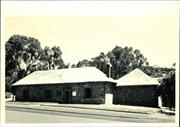
The place has historic value for its association with pensioner guard Hughes, the Donegan and Chitty families. The place has historic value as a good example of an 1870's pensioner guard cottage and it makes a contribution to the townscape of Toodyay.
A single storey red brick cottage with hipped iron roof, brick chimney and return verandah. Gabled side extension with tuck pointing. Flemish bond brickwork and timber casement windows. Rusting roofs and straining to verandah base.
The original owner in 1862 was Pensioner Guard Evan hughes. Later T.J. Donegan bought the place and made additions to the house. He ran Throssell's Newcastle Store after transferring from Northam following his father's death. in 1899 he bought the Victoria Hotel and made considerable extensions to it and had his own store. In 1891 Thomas Donegan's widow went to live at 'Rose Cottage' so she could be close to the family. In 1929, Donegan's cousin, C.F. Chitty, purchased the place and moved there to enable his children to attend school after the Ten Mile School closed.
Integrity: High Authenticity: Medium
Good
| Owner | Category |
|---|---|
| Chitty | Other Private |
This information is provided voluntarily as a public service. The information provided is made available in good faith and is derived from sources believed to be reliable and accurate. However, the information is provided solely on the basis that readers will be responsible for making their own assessment of the matters discussed herein and are advised to verify all relevant representations, statements and information.
30 Clinton St Toodyay
Cnr Henry St
Toodyay
Avon Arc
Constructed from 1872
| Type | Status | Date | Documents |
|---|---|---|---|
| Heritage List | Adopted | 01 Dec 2012 |
| Type | Status | Date | Documents |
|---|---|---|---|
| (no listings) |
| Type | Status | Date | Grading/Management | |
|---|---|---|---|---|
| Category | ||||
| Municipal Inventory | Adopted | 27 Aug 1998 | Category 3 | |
26408 Toodyay Townsite
Individual Building or Group
| Epoch | General | Specific |
|---|---|---|
| Original Use | RESIDENTIAL | Single storey residence |
| Present Use | RESIDENTIAL | Single storey residence |
| Type | General | Specific |
|---|---|---|
| Wall | BRICK | Common Brick |
| Roof | METAL | Corrugated Iron |
| General | Specific |
|---|---|
| DEMOGRAPHIC SETTLEMENT & MOBILITY | Settlements |
This information is provided voluntarily as a public service. The information provided is made available in good faith and is derived from sources believed to be reliable and accurate. However, the information is provided solely on the basis that readers will be responsible for making their own assessment of the matters discussed herein and are advised to verify all relevant representations, statements and information.
Constructed from 1862
The place has historic value for the claim that is was the first cottage built in the 1870's in this area. It has historic value for its associations with the pensioner guard Thomas Whittle. The place has aesthetic value for its contribution to the streetscape of Toodyay.
A single storey brick and iron cottage with verandah, timber sash and casement windows and hipped roof. Painted brickwork. Colonial style criss‐cross verandah balustrading. The original two roomed building of mud, straw and gravel was constructed on granite stone blocks. Later extensions were made of sun‐dried brick and kilned bricks.
The cottage is reputed to be the first built in the 'Pensioner Village' at the 'depot' after the town was gazetted in 1860. Thomas Whittle was an expiree and employed a ticket-of-leave bricklayer. He bought the block on 7 June 1871.
Integrity: Medium Authenticity: Low-Medium
Fair
| Owner | Category |
|---|---|
| Meyers & Keily | Other Private |
This information is provided voluntarily as a public service. The information provided is made available in good faith and is derived from sources believed to be reliable and accurate. However, the information is provided solely on the basis that readers will be responsible for making their own assessment of the matters discussed herein and are advised to verify all relevant representations, statements and information.