Local Government
Toodyay
Region
Avon Arc
30 Clinton St Toodyay
Cnr Henry St
Toodyay
Avon Arc
Constructed from 1872
| Type | Status | Date | Documents |
|---|---|---|---|
| Heritage List | Adopted | 01 Dec 2012 |
| Type | Status | Date | Documents |
|---|---|---|---|
| (no listings) |
| Type | Status | Date | Grading/Management | |
|---|---|---|---|---|
| Category | ||||
| Municipal Inventory | Adopted | 27 Aug 1998 | Category 3 | |
26408 Toodyay Townsite
Individual Building or Group
| Epoch | General | Specific |
|---|---|---|
| Original Use | RESIDENTIAL | Single storey residence |
| Present Use | RESIDENTIAL | Single storey residence |
| Type | General | Specific |
|---|---|---|
| Wall | BRICK | Common Brick |
| Roof | METAL | Corrugated Iron |
| General | Specific |
|---|---|
| DEMOGRAPHIC SETTLEMENT & MOBILITY | Settlements |
This information is provided voluntarily as a public service. The information provided is made available in good faith and is derived from sources believed to be reliable and accurate. However, the information is provided solely on the basis that readers will be responsible for making their own assessment of the matters discussed herein and are advised to verify all relevant representations, statements and information.
Constructed from 1862
The place has historic value for the claim that is was the first cottage built in the 1870's in this area. It has historic value for its associations with the pensioner guard Thomas Whittle. The place has aesthetic value for its contribution to the streetscape of Toodyay.
A single storey brick and iron cottage with verandah, timber sash and casement windows and hipped roof. Painted brickwork. Colonial style criss‐cross verandah balustrading. The original two roomed building of mud, straw and gravel was constructed on granite stone blocks. Later extensions were made of sun‐dried brick and kilned bricks.
The cottage is reputed to be the first built in the 'Pensioner Village' at the 'depot' after the town was gazetted in 1860. Thomas Whittle was an expiree and employed a ticket-of-leave bricklayer. He bought the block on 7 June 1871.
Integrity: Medium Authenticity: Low-Medium
Fair
| Owner | Category |
|---|---|
| Meyers & Keily | Other Private |
This information is provided voluntarily as a public service. The information provided is made available in good faith and is derived from sources believed to be reliable and accurate. However, the information is provided solely on the basis that readers will be responsible for making their own assessment of the matters discussed herein and are advised to verify all relevant representations, statements and information.
12 Drummond St Toodyay
West side of Drummond St GPS: 0448961 6509396
Toodyay
Avon Arc
Constructed from 1890
| Type | Status | Date | Documents |
|---|---|---|---|
| Heritage List | Adopted | 01 Dec 2012 |
| Type | Status | Date | Documents |
|---|---|---|---|
| (no listings) |
| Type | Status | Date | Grading/Management | |
|---|---|---|---|---|
| Category | ||||
| Municipal Inventory | Adopted | 27 Aug 1998 | Category 3 | |
Individual Building or Group
| Epoch | General | Specific |
|---|---|---|
| Original Use | RESIDENTIAL | One-and-a-half storey residence |
| Present Use | RESIDENTIAL | One-and-a-half storey residence |
| Style |
|---|
| Victorian Georgian |
| Type | General | Specific |
|---|---|---|
| Roof | METAL | Corrugated Iron |
| Wall | BRICK | Common Brick |
| Wall | STONE | Other Stone |
| General | Specific |
|---|---|
| PEOPLE | Innovators |
This information is provided voluntarily as a public service. The information provided is made available in good faith and is derived from sources believed to be reliable and accurate. However, the information is provided solely on the basis that readers will be responsible for making their own assessment of the matters discussed herein and are advised to verify all relevant representations, statements and information.
Constructed from 1890
The place has historic value as it is representative of development in Toodyay in the 1890's and is associated with prominent local builder Henry Hasell. The place has aesthetic value for its contribution to the streetscape in North Toodyay. The place has social value as a demonstration of a former way of life.
A single storey dwelling to road side with double height to rear. Constructed of brick, timber and weatherboard. The front verandah has a simple timber colonial criss-cross balustrade. There are vertically emphasised timber sash windows to the main facade and fanlight above the front door. The windows in the rear extension are metal framed picture windows of late twentieth century styling. The original cottage expressed a symmetrical facade representing the Georgian architectural stylisation. Weatherboard side and rear extension together with additional brick extension to the rear.
The homes was built by Henry Hasell in the 1890's. Henry was the son of the expiree convict, George Hasell, a builder. Henry was a builder as well and was responsible for building many of the houses in the Toodyay area. He had a brickworks adjacent to the house and used river mud from 300 metres upstream. After Henry died his son James, and his wife Alice, lived in the house. James leased the house at different times and during World War Two U.S. troops stayed at the house. James owned the place until 1985 when his widow sold it to R.J. Jodrell. Jodrell was also a builder and undertook renovations at that time.
Integrity: High Authenticity: Medium-High
Good
| Owner | Category |
|---|---|
| Frayne | Other Private |
This information is provided voluntarily as a public service. The information provided is made available in good faith and is derived from sources believed to be reliable and accurate. However, the information is provided solely on the basis that readers will be responsible for making their own assessment of the matters discussed herein and are advised to verify all relevant representations, statements and information.
14 Duke St Toodyay
Cnr Ellery Pl GPS: 0449506 6508754
Toodyay
Avon Arc
Constructed from 1920
| Type | Status | Date | Documents |
|---|---|---|---|
| Heritage List | Adopted | 01 Dec 2012 |
| Type | Status | Date | Documents |
|---|---|---|---|
| (no listings) |
| Type | Status | Date | Grading/Management | |
|---|---|---|---|---|
| Category | ||||
| Classified by the National Trust | Recorded | 02 Feb 1970 | ||
| Municipal Inventory | Adopted | 27 Aug 1998 | Category 3 | |
26408 Toodyay Townsite
Individual Building or Group
| Epoch | General | Specific |
|---|---|---|
| Original Use | RESIDENTIAL | Single storey residence |
| Present Use | RESIDENTIAL | Single storey residence |
| Style |
|---|
| Inter-War Art Deco |
| Type | General | Specific |
|---|---|---|
| Wall | BRICK | Common Brick |
| Roof | METAL | Corrugated Iron |
| General | Specific |
|---|---|
| DEMOGRAPHIC SETTLEMENT & MOBILITY | Settlements |
This information is provided voluntarily as a public service. The information provided is made available in good faith and is derived from sources believed to be reliable and accurate. However, the information is provided solely on the basis that readers will be responsible for making their own assessment of the matters discussed herein and are advised to verify all relevant representations, statements and information.
Constructed from 1920
The place has historic value as an example of the 1920's development in Toodyay. The building has aesthetic value as a good example of the style of residence from the period and for its contribution to the streetscape of Stirling Terrace.
Single storey brick dwelling with high hipped and gable roof, extensive verandah with colonial style timber criss-cross balustrading, sweeping steps at verandah corner, stained glass windows, timber framed sashes, rendered and timbered gables and round windows. Panelled and leaded light door with fanlights demonstrating the Art Deco influence. Red brick chimneys. House set in mature gardens.
The place was bought by Darby Connors on 8 December 1860. His wife was Sybil Donegan.
Integrity: High Authenticity: Medium
Good
| Owner | Category |
|---|---|
| Williams | Other Private |
This information is provided voluntarily as a public service. The information provided is made available in good faith and is derived from sources believed to be reliable and accurate. However, the information is provided solely on the basis that readers will be responsible for making their own assessment of the matters discussed herein and are advised to verify all relevant representations, statements and information.
2 Duke St Toodyay
GPS: 0449368 6509029
Toodyay community Resource Centre
Toodyay
Avon Arc
Constructed from 1900
| Type | Status | Date | Documents |
|---|---|---|---|
| Heritage List | Adopted | 01 Dec 2012 |
| Type | Status | Date | Documents |
|---|---|---|---|
| (no listings) |
| Type | Status | Date | Grading/Management | |
|---|---|---|---|---|
| Category | ||||
| Municipal Inventory | Adopted | 27 Aug 1998 | Category 3 | |
26408 Toodyay Townsite
Individual Building or Group
| Epoch | General | Specific |
|---|---|---|
| Original Use | EDUCATIONAL | Housing or Quarters |
| Present Use | SOCIAL\RECREATIONAL | Other Community Hall\Centre |
| Style |
|---|
| Federation Bungalow |
| Type | General | Specific |
|---|---|---|
| Roof | METAL | Corrugated Iron |
| Wall | BRICK | Common Brick |
| General | Specific |
|---|---|
| SOCIAL & CIVIC ACTIVITIES | Education & science |
This information is provided voluntarily as a public service. The information provided is made available in good faith and is derived from sources believed to be reliable and accurate. However, the information is provided solely on the basis that readers will be responsible for making their own assessment of the matters discussed herein and are advised to verify all relevant representations, statements and information.
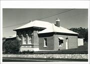
Constructed from 1900
The place has historic value as it is associated with the first purpose built school in Toodyay constructed at a period of development in the town. The place has social value for its association with the former way of life if schoolteachers. The place has aesthetic value for its contribution to the streetscape of Toodyay.
A red brick and iron cottage with hipped roof and brick chimneys. The front verandah is two-thirds open with one-third partially enclosed. English bond brickwork is evident and the side elevation has been partially rendered.
The school next door opened in May 1887 and these schoolmasters quarters were constructed three years later.
Integrity: Low-Medium Authenticity: Medium
Good
| Name | Type | Year From | Year To |
|---|---|---|---|
| Public Works Department of WA | Architect | 1900 | - |
| Owner | Category |
|---|---|
| Shire of Toodyay | Other Private |
This information is provided voluntarily as a public service. The information provided is made available in good faith and is derived from sources believed to be reliable and accurate. However, the information is provided solely on the basis that readers will be responsible for making their own assessment of the matters discussed herein and are advised to verify all relevant representations, statements and information.
3-5 Duke St Toodyay
Cnr Fiennes St GPS: 0449464 6508858
(Whitfields) Lavender Cottage
Toodyay
Avon Arc
Constructed from 1900
| Type | Status | Date | Documents |
|---|---|---|---|
| Heritage List | Adopted | 01 Dec 2012 |
| Type | Status | Date | Documents |
|---|---|---|---|
| (no listings) |
| Type | Status | Date | Grading/Management | |
|---|---|---|---|---|
| Category | ||||
| Municipal Inventory | Adopted | 27 Aug 1998 | Category 3 | |
26408 Toodyay Townsite
Individual Building or Group
| Epoch | General | Specific |
|---|---|---|
| Original Use | RESIDENTIAL | Single storey residence |
| Present Use | RELIGIOUS | Other |
| Style |
|---|
| Federation Bungalow |
| Type | General | Specific |
|---|---|---|
| Roof | METAL | Corrugated Iron |
| Wall | BRICK | Common Brick |
| General | Specific |
|---|---|
| DEMOGRAPHIC SETTLEMENT & MOBILITY | Settlements |
This information is provided voluntarily as a public service. The information provided is made available in good faith and is derived from sources believed to be reliable and accurate. However, the information is provided solely on the basis that readers will be responsible for making their own assessment of the matters discussed herein and are advised to verify all relevant representations, statements and information.
Constructed from 1900
The place has historic value as an example of 1900's development in Toodyay and for its association with Florence and Anita Whitfield. The place has aesthetic value for its contribution to the streetscape of the town of Toodyay.
A single storey brick and iron cottage with symmetrical facade. Hipped roof and tall painted brick chimney. Extensive verandahs with bullnose canopy and filigree brackets and fretted timber panels. Timber outbuilding.
D. Connors bought this lot in 1860. The house, which is thought to have been constructed by Oliver Whitfield, a carpenter, was built c.1900 and was occupied by Florence Whitfield for her lifetime and then Anita Whitfield who had been brought up by Florence following her mother's death in 1921.
Integrity: Medium-High Authenticity: Low-Medium
Good
| Owner | Category |
|---|---|
| Cruickshank | Other Private |
This information is provided voluntarily as a public service. The information provided is made available in good faith and is derived from sources believed to be reliable and accurate. However, the information is provided solely on the basis that readers will be responsible for making their own assessment of the matters discussed herein and are advised to verify all relevant representations, statements and information.
6 Duke St Toodyay
GPS: 0449358 6509059
Toodyay Repertory Club, Toodyay School
Toodyay Uniting Church (Methodist)
Toodyay
Avon Arc
Constructed from 1886 to 1887
| Type | Status | Date | Documents |
|---|---|---|---|
| Heritage List | Adopted | 01 Dec 2012 |
| Type | Status | Date | Documents |
|---|---|---|---|
| RHP - Does not warrant assessment | Current | 08 Aug 2003 |
| Type | Status | Date | Grading/Management | |
|---|---|---|---|---|
| Category | ||||
| Classified by the National Trust | Recorded | 07 Jun 1977 | ||
| Uniting Church Inventory | Completed | 01 Oct 1996 | ||
| Municipal Inventory | Adopted | 27 Aug 1998 | Category 2 | |
04128 Stirling Terrace Streetscape Group
| Name | Type | Year From | Year To |
|---|---|---|---|
| George Temple-Poole | Architect | - | - |
Individual Building or Group
| Epoch | General | Specific |
|---|---|---|
| Present Use | RELIGIOUS | Church, Cathedral or Chapel |
| Original Use | EDUCATIONAL | Combined School |
| Style |
|---|
| Victorian Academic Gothic |
| Type | General | Specific |
|---|---|---|
| Roof | TIMBER | Shingle |
| Wall | BRICK | Common Brick |
| General | Specific |
|---|---|
| SOCIAL & CIVIC ACTIVITIES | Education & science |
| SOCIAL & CIVIC ACTIVITIES | Religion |
This information is provided voluntarily as a public service. The information provided is made available in good faith and is derived from sources believed to be reliable and accurate. However, the information is provided solely on the basis that readers will be responsible for making their own assessment of the matters discussed herein and are advised to verify all relevant representations, statements and information.
Constructed from 1900, Constructed from 1886
The former Newcastle School established in 1886 has historic value as the first purpose built school in Toodyay. The place has aesthetic and historic value as an example of George temple Poole's architecture. The place has aesthetic value as a landmark and for its contribution to the streetscape of Toodyay. The place demonstrates social value for the contribution to the sense of place for generations of students and church goers since the 1880's. The place has historic value as it demonstrates the evolution of the place through change of use. It became a church and has considerable association with the Methodist and Uniting church communities.
The building is of red brick construction laid in Flemish bond. High pitched gable roof, originally with shingle roof, now corrugated iron. Timber sash windows with rendered window dressings. Timbered bargeboard on gable. Tall chimney. The classroom extension is of single storey construction with low pitched roof and tall chimney. Constructed of red brick and corrugated iron roof. Both buildings sit on partially rendered plinths.
After flooding in the Toodyay townsite, the school was temporarily closed and the Education Board urged the establishment of a school in the newly gazetted town of Toodyay. It was proposed to use the Commissariat Store and quarters, but they were taken for convict purposes, and the money was reallocated to buying land and building a new school. Students were educated from 1867 first by Mrs Farmer, wife of Thomas Farmer, and then by Mrs Innes, wife of the Congregational Minister. Both women taught in their homes. Rev & Mrs. Innes were very active in eduction and community affairs, and succeeded in securing the former policeman's depot cottage for a school room in 1873. It was inadequate and moves for a school became more intense. Mrs Whitfield opened a private school in 1871 and in 1874 an unofficial Catholic school opened. By 1882, the school room was in poor condition with 50 students in one room and the teacher having been allocated to other room in 1879 for living quarters. In the mid 1880's the poor condition of many government buildings in Toodyay prompted a number of renovation works, and plans for a new school, and the old school being converted into a hospital. The school opened in May 1887. In 1897, the Newcastle Wesleyans raised funds to build a church near the school. In 19554, the school closed, and the building was used by the local repertory club who purchased the property in 1959. After the Methodist church was demolished in 1962, to make way for the standard gauge railway line, the church used the former school. In May 1993 after fire destroyed the new Toodyay School, the building was again used as s school until temporary classrooms were provided while the school was rebuilt.
Integrity: Moderate Authenticity: Moderate
Fair
| Name | Type | Year From | Year To |
|---|---|---|---|
| George Temple Poole | Architect | 1886 | - |
| Owner | Category |
|---|---|
| Uniting Church in Australia Property Trust (WA) Inc | Church Property |
This information is provided voluntarily as a public service. The information provided is made available in good faith and is derived from sources believed to be reliable and accurate. However, the information is provided solely on the basis that readers will be responsible for making their own assessment of the matters discussed herein and are advised to verify all relevant representations, statements and information.
7-11 Duke St Toodyay
GPS: 0449483 6508815
Toodyay
Avon Arc
Constructed from 1900
| Type | Status | Date | Documents |
|---|---|---|---|
| Heritage List | Adopted | 01 Dec 2012 |
| Type | Status | Date | Documents |
|---|---|---|---|
| (no listings) |
| Type | Status | Date | Grading/Management | |
|---|---|---|---|---|
| Category | ||||
| Municipal Inventory | Adopted | 27 Aug 1998 | Category 3 | |
26408 Toodyay Townsite
Individual Building or Group
| Epoch | General | Specific |
|---|---|---|
| Original Use | RESIDENTIAL | Single storey residence |
| Present Use | RESIDENTIAL | Single storey residence |
| Style |
|---|
| Federation Bungalow |
| Type | General | Specific |
|---|---|---|
| Wall | BRICK | Common Brick |
| Roof | METAL | Corrugated Iron |
| General | Specific |
|---|---|
| DEMOGRAPHIC SETTLEMENT & MOBILITY | Settlements |
This information is provided voluntarily as a public service. The information provided is made available in good faith and is derived from sources believed to be reliable and accurate. However, the information is provided solely on the basis that readers will be responsible for making their own assessment of the matters discussed herein and are advised to verify all relevant representations, statements and information.
Constructed from 1900
Te place has historic value for its associations with Jospeh Ablett Wroth and his extended family. The place has social value as an example of turn of the century housing in Toodyay. The place has aesthetic value for its contribution to the streetscape of Toodyay.
A single storey brick dwelling with complex iron roof form of gables, hips, angles, bay window roof and verandah roof. 'L' shaped with projecting wing gabled with prominent bay window with timber sashes. Various chimneys.
Daniel Connor bought this lot on 8 December 1860. The original home was that of Joseph Ablett Wroth. In 1884 Dr Mayhew engaged Wroth to renovate Dr. Growse's former house and Wroth also built Spion Kop for E. Holliday in about 1894. By 1889 he succeeded his brother as clerk to the Municipal Council and in 1890 was Clerk to the Road Board. He was notable for his 41 years service as Clerk to local government in Toodyay. he was called the 'town's father confessor' as he assisted illiterate people in the district with their business and knew much of everyone's affairs. He also kept the records for the Anglican Church and the Agricultural Society. During the 1906 typhoid epidemic Wroth and Demasson built many of the coffins which were required.
Integrity: Medium Authenticity: Medium
Good
| Owner | Category |
|---|---|
| Cleasby | Other Private |
This information is provided voluntarily as a public service. The information provided is made available in good faith and is derived from sources believed to be reliable and accurate. However, the information is provided solely on the basis that readers will be responsible for making their own assessment of the matters discussed herein and are advised to verify all relevant representations, statements and information.
Dumbarton Rd Toodyay
MI States; Address is Nairn Drive Dumbarton GPS: Nairn Cottage 0455357 6505238 Dumbarton Homestead 0454758 6506698 Large fig near homestead 0454766 6506683 Shearing Shed 0454524 6506485
Homestead
Sinclairs Crossing, Nairn Cottage, Dumbarton
Toodyay
Avon Arc
Constructed from 1908
| Type | Status | Date | Documents |
|---|---|---|---|
| Heritage List | Adopted | 01 Dec 2012 |
| Type | Status | Date | Documents |
|---|---|---|---|
| (no listings) |
| Type | Status | Date | Grading/Management | |
|---|---|---|---|---|
| Category | ||||
| Municipal Inventory | Adopted | 27 Aug 1998 | Category 2 | |
| Library Id | Title | Medium | Year Of Publication |
|---|---|---|---|
| 7915 | Toodyay homesteads: past and present. | Book | 2006 |
Individual Building or Group
| Epoch | General | Specific |
|---|---|---|
| Other Use | FARMING\PASTORAL | Shed or Barn |
| Present Use | FARMING\PASTORAL | Homestead |
| Original Use | FARMING\PASTORAL | Homestead |
| Style |
|---|
| Federation Bungalow |
| Type | General | Specific |
|---|---|---|
| Wall | STONE | Other Stone |
| Other | EARTH | Other Earth |
| General | Specific |
|---|---|
| DEMOGRAPHIC SETTLEMENT & MOBILITY | Settlements |
This information is provided voluntarily as a public service. The information provided is made available in good faith and is derived from sources believed to be reliable and accurate. However, the information is provided solely on the basis that readers will be responsible for making their own assessment of the matters discussed herein and are advised to verify all relevant representations, statements and information.
Constructed from 1834, Constructed from 1960
The three places have historic value for their associations with the development of the pastoral industry in the 19th century. The buildings represent the development and division of the original landholding. The places have historic value for their associations with early settlers, the McDermott, Nairn and Sinclair families.
1) Nairn Cottage: Single storey dwelling, twin low iron hipped roofs with a gambrel roofed verandah extending around the property. Timber sash windows. The original dwelling has been substantially extended but one roof covers the entire property giving the impression of a one-stage construction. iron outbuilding to the rear. 2) Dumbarton Homestead: single storey painted brick structure, integral verandah which is open with timber posts. Timber sash windows and brick chimney. Twin hipped roofs with valley between the two. Gabled portico with timbering and central steps to the verandah and main entrance. 3) Shearing Shed: restored and now forms part of a larger residential dwelling. Bush timber verandah posts, timber verandah floor, retained defence holes.
These places were part of Major Nairn's grant of 1200 acres called 'Dumbarton' which lacked a water supply and was too small for free range pasturing. Nairn leased (with option of sale or purchase) McDermott's grant 'Mounatin Park', of another 5000 acres which included Gabbigin Spring. In june 1939 he advertised the combined grants (called at this time 'Mountain Park') and described it as a well-equipped farm, a newly-built house with two bedrooms, a sitting room and a storeroom with necessary outbuildings, however it seems that the original McDermott grant passed back to that family's hands. Henry Slade became the lessee for a short time before James B. Sinclair took the lease with option to purchase and when he took this option he named the property 'Dumbarton'. Sinclair and his wife and young son came to the colony in 1840. He was indentured to Lionel Lukin and worked as a shepherd. Sinclair built a cottage near a ford crossing the Avon River and he conducted a wayside inn, hiring Richard Kirby to Shepherd his sheep. kirby carved his name and the date, 1849, on a large rock on the property. Sinclair was appointed to the Toodyay Education Board in 1875 and served on the Toodyay Roads Board from 1872 to 1895. he built a two-storey house by the riverside and enlarged his land holdings before his death in 1899.
Integrity: Medium Authenticity: Medium
Fair
| Owner | Category |
|---|---|
| Avonmore Farm Development Pty Ltd | Other Private |
This information is provided voluntarily as a public service. The information provided is made available in good faith and is derived from sources believed to be reliable and accurate. However, the information is provided solely on the basis that readers will be responsible for making their own assessment of the matters discussed herein and are advised to verify all relevant representations, statements and information.
389 Dumbarton Rd Toodyay
GPS: 0457382 6507498
Toodyay
Avon Arc
Constructed from 1860
| Type | Status | Date | Documents |
|---|---|---|---|
| Heritage List | Adopted | 01 Dec 2012 |
| Type | Status | Date | Documents |
|---|---|---|---|
| RHP - To be assessed | Current | 27 Feb 2004 |
| Type | Status | Date | Grading/Management | |
|---|---|---|---|---|
| Category | ||||
| Municipal Inventory | Adopted | 27 Aug 1998 | Category 1 | |
| Classified by the National Trust | Classified | 07 Jun 1977 | ||
| Register of the National Estate | Permanent | 21 Oct 1980 | ||
· The place comprises a number of buildings constructed in similar style and materials and which forms a cultural environment with associations to the workings of the granary.
· The larger brick granary building comprising a single and a double storey section is a landmark in the rural setting.
· The place has associations with the settlement of the Toodyay area and in particular with the farming industry.
· The place has associations with James Twine.
· The place has rarity value.
The place comprises a granary, outbuildings and 2 dwellings; one of which is located approximately 100-200 metres away on a hill above the granary. This building is a single storey brick bungalow with a hipped cgi roof and perimeter verandahs. The granary is a brick building comprising a single and double storey section. The roof is hipped and clad with new cgi, and there is a verandah along the south-west side. The small cottage located in close proximity to the granary building has reverse tone Flemish bond brickwork.
‘James Twine came to the colony as a labourer in 1833, buying a farm in Guildford, he traded it in 1852, for Dr Viveash’s location 32. He came to the Toodyay district in the early 1850s, and was one of the few settlers who established themselves through the 1860s, further property purchases resulted in a 1400 acre property known as ‘Newgain’. He and his sons also took large pastoral leases to the east, and developed the neighbouring farm, ‘Maisemore’. James Twine was as inaugural member of the Toodyay Road Board.’
Integrity- Moderate Authenticity- High
Good
| Name | Type | Year From | Year To |
|---|---|---|---|
| Twine, James | Architect | - | - |
Individual Building or Group
| Epoch | General | Specific |
|---|---|---|
| Original Use | FARMING\PASTORAL | Silo or Grain Shed |
| Present Use | FARMING\PASTORAL | Homestead |
| Present Use | EDUCATIONAL | Museum |
| Original Use | FARMING\PASTORAL | Homestead |
| Style |
|---|
| Victorian Georgian |
| Type | General | Specific |
|---|---|---|
| Roof | METAL | Corrugated Iron |
| Wall | BRICK | Common Brick |
| General | Specific |
|---|---|
| OCCUPATIONS | Grazing, pastoralism & dairying |
This information is provided voluntarily as a public service. The information provided is made available in good faith and is derived from sources believed to be reliable and accurate. However, the information is provided solely on the basis that readers will be responsible for making their own assessment of the matters discussed herein and are advised to verify all relevant representations, statements and information.
Constructed from 1860
The place has historic value as it demonstrates the development of the agriculture industry in the late 19th century. The place is rare is it is the only remaining granary in the Toodyay area. The place has historic value for its long associations with the Twine family.
Structure of two sections. There is a symmetrical face to the main two storey granary building with 3x9 paned windows set in rounded arches to the upper level. Whilst the lower level of the main building and the single storey wing demonstrate the same rhythm in the openings of window-door-window. Both sections are of red brick construction on a stone base with hipped iron roof. There are wall ties to the front elevation of the main section. The rear elevation mirrors the front in terms of rhythm of openings, the central opening being a grain access on this elevation. A verandah extends along the entire rear elevation, a simple structure of skillion supported on timber posts. A range of outbuildings are sited a short distance from the main granary; a mudbrick and red brick structure on a stone base, pitched roof with timber gable ends and a red brick structure. Adjacent are the remains of a stone structure.
James Twine came to the colony as a labourer in 1833 and bought a farm in Guildford. he traded this farm with Dr Viveash's Toodyay holdings in 1852 in order to consolidate his land with his stepson's inherited lands. Further purchases during the 1860's lead to a 1400 acre property he called 'Newgain'. He and his sons also took large pastoral leases to the east and developed the neighbouring farm, 'Maismore'. James Twine was an inaugural member of the Toodyay road Board. He retired in 1874 and his sons took over the management of the properties.
Integrity: High Authenticity: High
Good
| Name | Type | Year From | Year To |
|---|---|---|---|
| James Twine | Architect | - | - |
| Owner | Category |
|---|---|
| Lefroy | Other Private |
This information is provided voluntarily as a public service. The information provided is made available in good faith and is derived from sources believed to be reliable and accurate. However, the information is provided solely on the basis that readers will be responsible for making their own assessment of the matters discussed herein and are advised to verify all relevant representations, statements and information.
466 Dumbarton Rd Toodyay
GPS: 0457768 6506666
Toodyay
Avon Arc
Constructed from 1860
| Type | Status | Date | Documents |
|---|---|---|---|
| Heritage List | Adopted | 01 Dec 2012 |
| Type | Status | Date | Documents |
|---|---|---|---|
| (no listings) |
| Type | Status | Date | Grading/Management | |
|---|---|---|---|---|
| Category | ||||
| Municipal Inventory | Adopted | 27 Aug 1998 | Category 2 | |
| Library Id | Title | Medium | Year Of Publication |
|---|---|---|---|
| 7915 | Toodyay homesteads: past and present. | Book | 2006 |
Individual Building or Group
| Epoch | General | Specific |
|---|---|---|
| Present Use | FARMING\PASTORAL | Homestead |
| Original Use | FARMING\PASTORAL | Homestead |
| Style |
|---|
| Victorian Georgian |
| Type | General | Specific |
|---|---|---|
| Roof | METAL | Corrugated Iron |
| Wall | BRICK | Common Brick |
| General | Specific |
|---|---|
| DEMOGRAPHIC SETTLEMENT & MOBILITY | Settlements |
This information is provided voluntarily as a public service. The information provided is made available in good faith and is derived from sources believed to be reliable and accurate. However, the information is provided solely on the basis that readers will be responsible for making their own assessment of the matters discussed herein and are advised to verify all relevant representations, statements and information.
Constructed from 1890, Constructed from 1860
The place has historic value for its associations with the McDermott family and the establishment of the pastoral industry in the district. The place has aesthetic value as an illustration of early construction techniques and materials. The site has research value as it has potential to contain subsurface archaeological remains. The place has historic value as it demonstrates the development of the homestead complex from the 1880's.
Originally a four roomed brick and shingle cottage that was extended in c.1890 adding the gabled wings creating a symmetrical frontage to the property. The original cottage had bush timber rafters and a shingle roof which can still be seen under the present iron roof. The property was further extended to the rear in the 1960's with asbestos cladding and incorporating mirroring twin gables. Two outbuildings set away from the house of iron construction on stone bases, with hipped roofs. One is a simple rectangular shape whilst the larger construction has two side sections reflecting the particular use of the shed.
'Neugin' homestead was built in 1886 by Charles McDermott, grandson of Captain James McDermott, who came to the colony with his wife and son in 1832. James McDermott was granted 5000 acres which he occupied before his drowning in 1834, following which Major Nairn leased the place but it eventually returned to the McDermott family. In 1844 James McDermott's widow, Nancy, married Dr Alfred Green who became the District Medical Officer at Toodyay. Her son, James McDermott left the colony for England and then fought in the United States' Civil War. Returning in 1867 with his family, just weeks after his mother's death, James took up the McDermott grant. He built a bigger house and named it 'Oaklands'. His son Charles, inherited part of the property, which he named 'Neugin' and built the homestead. James McDermott died in 1910 and was buried, along with his mother, in the Nardie cemetery.
Integrity: Medium Authenticity: High
Good
| Owner | Category |
|---|---|
| McDermott | Other Private |
This information is provided voluntarily as a public service. The information provided is made available in good faith and is derived from sources believed to be reliable and accurate. However, the information is provided solely on the basis that readers will be responsible for making their own assessment of the matters discussed herein and are advised to verify all relevant representations, statements and information.
Lot 11 Dumbarton Rd Toodyay
GPS: 0457701 6507170
Toodyay
Avon Arc
Constructed from 1930
| Type | Status | Date | Documents |
|---|---|---|---|
| (no listings) |
| Type | Status | Date | Documents |
|---|---|---|---|
| (no listings) |
| Type | Status | Date | Grading/Management | |
|---|---|---|---|---|
| Category | ||||
| Municipal Inventory | Removed from MI | 11 Jan 2013 | ||
Individual Building or Group
| Epoch | General | Specific |
|---|---|---|
| Present Use | RESIDENTIAL | Single storey residence |
| Original Use | RESIDENTIAL | Single storey residence |
| Type | General | Specific |
|---|---|---|
| Wall | BRICK | Common Brick |
| Roof | METAL | Corrugated Iron |
| General | Specific |
|---|---|
| DEMOGRAPHIC SETTLEMENT & MOBILITY | Settlements |
This information is provided voluntarily as a public service. The information provided is made available in good faith and is derived from sources believed to be reliable and accurate. However, the information is provided solely on the basis that readers will be responsible for making their own assessment of the matters discussed herein and are advised to verify all relevant representations, statements and information.
Constructed from 1930
The site has historic value for the associations with the railways and Chinese market gardening in the area. The site has research value as it has potential to contain subsurface archaeological remains.
A substantially altered and extended red brick dwelling with green corrugated iron roof and c.1930's extensions and alterations which have removed much of the original character of the house. Many windows have been replaced. There is decorative iron work to the verandah. garage constructed of stone, brick and mudbrick with a pitched iron roof.
James Twine came to the colony as a labourer in 1833 and bought a farm in Guildford which he traded for Dr. Viveash's location 32. Twine came to the Toodyay district in the early 1850's and was one of the few settlers who established themselves through the 1860's. Further property purchases resulted in a 1400 acre property known as 'Newgain'. He built the considerable granary and he and his sons also took large pastoral leases to the east and developed this neighbouring farm. 'Maisemore' is the nucleus of the original 618 acre grant. It was subdivided in 1927 and 'Maisemore' was sold to B.M. Connor who sold it to Minchin Bros, who in turn sold it to Sir Ernest Lee Steere in 1837 who bought it for his son. After his son's death during World War Two it was bought by Robert Fortescue Temperley.
Integrity: Low Authenticity: Low
Fair
| Owner | Category |
|---|---|
| Yandie Holding Pty Ltd | Other Private |
This information is provided voluntarily as a public service. The information provided is made available in good faith and is derived from sources believed to be reliable and accurate. However, the information is provided solely on the basis that readers will be responsible for making their own assessment of the matters discussed herein and are advised to verify all relevant representations, statements and information.
13-14 Fiennes St Toodyay
GPS: 0449154 6508861 14/11/2011 Address includes: 4 Duke St & portion of Anzac Ave, Toodyay. (Also previously known as Toodyay Shire Council) MI States: 13-17 Fiennes St BDD 22-1-13
Convict Hiring Depot & Hospital sites
Toodyay Court House (fmr)
Toodyay
Avon Arc
Constructed from 1852 to 1897
| Type | Status | Date | Documents |
|---|---|---|---|
| Heritage List | Adopted | 01 Dec 2012 | |
| State Register | Registered | 24 Oct 2014 | HCWebsite.Listing+ListingDocument, HCWebsite.Listing+ListingDocument |
| Type | Status | Date | Documents |
|---|---|---|---|
| (no listings) |
| Type | Status | Date | Grading/Management | |
|---|---|---|---|---|
| Category | ||||
| Classified by the National Trust | Classified | 07 Jun 1977 | ||
| Aboriginal Heritage Sites Register | Adopted | |||
| Municipal Inventory | Adopted | 27 Aug 1998 | Category 1 | |
26408 Toodyay Townsite
The condition of the various elements within Toodyay Court House (fmr) and former Convict Depot Archaeological Sites varies. Overall the place is in good condition. The Convict Depot survives only as archaeological features, deposits and foundations. These are highly intact as archaeological sites.
| Name | Type | Year From | Year To |
|---|---|---|---|
| George Temple Poole | Architect | 1896 | 1897 |
| Lt Edmund DuCane | Architect | 1852 | - |
| Library Id | Title | Medium | Year Of Publication |
|---|---|---|---|
| 9970 | Conservation management plan for the archaelogical remains at Newcastle Convict Depot (Toodyay) | Heritage Study {Cons'n Plan} | 2011 |
| 11615 | Transforming the colony: the archaeology of convictism in Western Australia | Book | 2017 |
| 9713 | The history of the Toodyay convict depot: a tale of the convict era of Western Australia. | Book | 2010 |
Individual Building or Group
| Epoch | General | Specific |
|---|---|---|
| Original Use | RESIDENTIAL | Institutional Housing |
| Present Use | GOVERNMENTAL | Town, Shire or District Hall |
| Original Use | GOVERNMENTAL | Other |
| Original Use | HEALTH | Hospital |
| Original Use | GOVERNMENTAL | Courthouse |
| Style |
|---|
| Federation Free Classical |
| Type | General | Specific |
|---|---|---|
| Wall | BRICK | Common Brick |
| Wall | STONE | Local Stone |
| Roof | METAL | Corrugated Iron |
| General | Specific |
|---|---|
| DEMOGRAPHIC SETTLEMENT & MOBILITY | Settlements |
| SOCIAL & CIVIC ACTIVITIES | Institutions |
| PEOPLE | Early settlers |
| DEMOGRAPHIC SETTLEMENT & MOBILITY | Workers {incl. Aboriginal, convict} |
| DEMOGRAPHIC SETTLEMENT & MOBILITY | Government policy |
| SOCIAL & CIVIC ACTIVITIES | Law & order |
This information is provided voluntarily as a public service. The information provided is made available in good faith and is derived from sources believed to be reliable and accurate. However, the information is provided solely on the basis that readers will be responsible for making their own assessment of the matters discussed herein and are advised to verify all relevant representations, statements and information.
Constructed from 1896
The site has historic value for its associations with the beginnings of the depot at Toodyay and the provision of law and order. The former courthouse has aesthetic value as it is a fine example of the architecture of George Temple Poole, and complements another example of his work in the Toodyay Post Office. The place has social value for its role as the centre of civic administration and has associations with community leaders. The place is a landmark which makes a significant contribution to the townscape.
Single storey brick structure with corrugated iron hipped roof. Main projecting bay characterised by a series of three full-height arched windows with painted dressings incorporating a feature keystone voussoir. The building sits upon a rendered plinth which emphasises the change in topography across the site. Main entrance is via steps up to a colonnaded verandah. Timber sash windows with 9-paned top window above single pane window. Additions to rear with temporary offices and ancillary accommodation.
This building was constructed in 1896, opening in January 1897. It replaced the original courthouse on the site which was built in 1867 to the design of Richard Roach Jewell. The site was also previously used as a convict hiring depot, one of three established in the colony after convicts were introduced in 1850. In 1902 the last Resident Magistrate was withdrawn and the building was vacated. Many of the records which were stored in the building in the ensuing years were destroyed. The old warders' quarters were demolished in about 1931. In the process of the Road Board renovating the place in the 1950's the adjacent old hospital was demolished. The building has been used as the local government administrative centre since then with some additions taking place to facilitate the development of that function.
Integrity: Medium-Low Authenticity: Medium-Low
Good
| Name | Type | Year From | Year To |
|---|---|---|---|
| George Temple Poole | Architect | - | - |
| Richard Roach Jewell | Architect | - | - |
| Owner | Category |
|---|---|
| Shire of Toodyay | Local Gov't |
This information is provided voluntarily as a public service. The information provided is made available in good faith and is derived from sources believed to be reliable and accurate. However, the information is provided solely on the basis that readers will be responsible for making their own assessment of the matters discussed herein and are advised to verify all relevant representations, statements and information.

19 Fiennes St Toodyay
Temperance Hall
Templar's Hall (fmr)
Toodyay
Avon Arc
Constructed from 1879 to 1900
| Type | Status | Date | Documents |
|---|---|---|---|
| Heritage List | Adopted | 01 Dec 2012 |
| Type | Status | Date | Documents |
|---|---|---|---|
| (no listings) |
| Type | Status | Date | Grading/Management | |
|---|---|---|---|---|
| Category | ||||
| Municipal Inventory | Adopted | 27 Aug 1998 | Category 2 | |
| Classified by the National Trust | Recorded | 07 Jun 1977 | ||
26408 Toodyay Townsite
Individual Building or Group
| Epoch | General | Specific |
|---|---|---|
| Present Use | SOCIAL\RECREATIONAL | Other Community Hall\Centre |
| Original Use | RELIGIOUS | Church, Cathedral or Chapel |
| Style |
|---|
| Victorian Free Gothic |
| Type | General | Specific |
|---|---|---|
| Wall | BRICK | Common Brick |
This information is provided voluntarily as a public service. The information provided is made available in good faith and is derived from sources believed to be reliable and accurate. However, the information is provided solely on the basis that readers will be responsible for making their own assessment of the matters discussed herein and are advised to verify all relevant representations, statements and information.
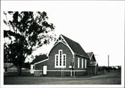
Constructed from 1879
The place has historic value for its associations with the Templars, Methodist Church, Rev Holliday and the Freemasons. The place has aesthetic value for its contribution to the townscape of Toodyay.
Tall Gothic style Mason hall with steep pitched iron roof and tall narrow windows set in recessed rounded arch openings. The extension to the rear with skillion roof is of a lean-to style. painted brick and half timbering to gable apex are present. The front door is bricked in but the original dressings around the opening is still visible. The side extension of timber and iron on stumps adjoins a brick structure with shallower pitched gable roof and timber vented gable apex. There are high level small windows at rear.
Interest in the Temperance movement was fostered by Thomas Farmer, a travelling agent in 1880. He addressed meetings in his role as Grand Worthy Chief Good Templar. The movement gathered strenght and children joined the Band of Hope. The original building was constructed in 1879 on land donated by Charles Marris for the purpose of a temple. Marris was one of the leading temperance workers and he trained a brass band which played at public functions. The Templars used the place and it was also the venue for Methodist Church services until 1898 when their own church was constructed. The very popular annual Christmas Tree concert conducted by the Methodists was first held at the Mechanics' Institute in 1887 to raise funds for seats at the Temperance Hall. In 1894 Rev. E Holliday took over the eastern district circuit of the Wesleyan congregation and although he retired in 1895 he was later Mayor of Toodyay from 1897 to 1898 and the first Master of the Freemasons, buying the Templar Lodge in 1899.
Integrity: Medium Authenticity: Low
Fair-Good
| Name | Type | Year From | Year To |
|---|---|---|---|
| Percy W Harrison | Architect | - | - |
| Owner | Category |
|---|---|
| Toodyay Masonic Lodge | Church Property |
This information is provided voluntarily as a public service. The information provided is made available in good faith and is derived from sources believed to be reliable and accurate. However, the information is provided solely on the basis that readers will be responsible for making their own assessment of the matters discussed herein and are advised to verify all relevant representations, statements and information.
7 Fiennes St Toodyay
GPS: 0449347 6508892
Lee Steere Home
Whitfield House
Toodyay
Avon Arc
Constructed from 1863
| Type | Status | Date | Documents |
|---|---|---|---|
| Heritage List | Adopted | 01 Dec 2012 |
| Type | Status | Date | Documents |
|---|---|---|---|
| (no listings) |
| Type | Status | Date | Grading/Management | |
|---|---|---|---|---|
| Category | ||||
| Municipal Inventory | Adopted | 27 Aug 1998 | Category 3 | |
26408 Toodyay Townsite
Individual Building or Group
| Epoch | General | Specific |
|---|---|---|
| Other Use | EDUCATIONAL | Primary School |
| Present Use | RESIDENTIAL | Single storey residence |
| Original Use | RELIGIOUS | Housing or Quarters |
| Present Use | COMMERCIAL | Other |
| Original Use | RESIDENTIAL | Single storey residence |
| Type | General | Specific |
|---|---|---|
| Wall | STONE | Other Stone |
| Roof | METAL | Corrugated Iron |
| General | Specific |
|---|---|
| DEMOGRAPHIC SETTLEMENT & MOBILITY | Settlements |
This information is provided voluntarily as a public service. The information provided is made available in good faith and is derived from sources believed to be reliable and accurate. However, the information is provided solely on the basis that readers will be responsible for making their own assessment of the matters discussed herein and are advised to verify all relevant representations, statements and information.
Constructed from 1863
The place has historic value for its associations with John A Wroth, Mrs G Whitfield, A lee Steere and the Anglican Church. The place has social value for its association with the development of education in Toodyay. The place has aesthetic value for its contribution to the townscape of Toodyay.
A single storey extended dwelling of brick and iron construction with rendered arches to door and window openings, brick chimneys and casement windows. The front verandah has timber posts and colonial style criss-cross balustrading. Door and window openings create a regular rhythm across the front elevation.
The original owner of the place was John Acton Wroth who purchased the lot in 1861. Wroth was Secretary to the York Resident Magistrate in 1851 and then postmaster at the Toodyay Post Office in 1854. He was also the Clerk of Courts and Clerk to the Resident Magistrate as well as Secretary of the Agricultural Society. When Toodyay Post Office closed c.1864, Wroth was postmaster for a brief period in Newcastle. In 1865 J. Drummond engaged Wroth to teach his and his workmen's children in the empty steam mill until a government school master could be found. From 1871 the place was used by Mrs G. Whitfield as a private school. In 1873 the Toodyay Board of Education was formed and Augustus Frederick Lee Steere (1835-1903) was a member. In 1887 after retiring from farming, A Lee Steere purchased the house and added two rooms on the east end. He bequeathed the place to the Anglican Church on his death in 1903. the first clergyman to occupy the rectory was Rev John Ellis. It later became a private residence.
Integrity: Medium Authenticity: Medium
Good
| Owner | Category |
|---|---|
| Smith | Other Private |
This information is provided voluntarily as a public service. The information provided is made available in good faith and is derived from sources believed to be reliable and accurate. However, the information is provided solely on the basis that readers will be responsible for making their own assessment of the matters discussed herein and are advised to verify all relevant representations, statements and information.
8 Fiennes St Toodyay
GPS: 0499300 6508888
Burnside Cottage
Warden's Cottage
Toodyay
Avon Arc
Constructed from 1860
| Type | Status | Date | Documents |
|---|---|---|---|
| Heritage List | Adopted | 01 Dec 2012 |
| Type | Status | Date | Documents |
|---|---|---|---|
| (no listings) |
| Type | Status | Date | Grading/Management | |
|---|---|---|---|---|
| Category | ||||
| Municipal Inventory | Adopted | 27 Aug 1998 | Category 3 | |
26408 Toodyay Townsite
Individual Building or Group
| Epoch | General | Specific |
|---|---|---|
| Present Use | RESIDENTIAL | Single storey residence |
| Original Use | RESIDENTIAL | Single storey residence |
| Type | General | Specific |
|---|---|---|
| Wall | BRICK | Common Brick |
| Roof | METAL | Corrugated Iron |
| General | Specific |
|---|---|
| DEMOGRAPHIC SETTLEMENT & MOBILITY | Settlements |
This information is provided voluntarily as a public service. The information provided is made available in good faith and is derived from sources believed to be reliable and accurate. However, the information is provided solely on the basis that readers will be responsible for making their own assessment of the matters discussed herein and are advised to verify all relevant representations, statements and information.
Constructed from 1860
The place has historic value through its association with Police Constables in the 1860's and Fred Green and his livery stables in the 1890's. The building is a rare example of a cottage from the 1860's that is not a Pensioners Cottage and for its unusual placement on the block. The place has aesthetic value for its contribution to the streetscape in Toodyay and the Bunya Pine in the front yard is a local landmark.
Single storey brick and iron cottage with open front verandah to rear and a hipped and gabled roof. Weatherboard extension to the rear.
Police Constable Ebenezer Martin bought the block in 1861 but sold it to Police Constable Thomas Sarsfield Burnside who had transferred from York to Toodyay. He undertook the duties of postmaster for Toodyay in 1863. In 1869 he was transferred to Rottnest Island as Warder. In the 1890's Fred Green ran a prosperous livery stables at this site. When gold was discovered at Blackboy hill in 1897 his services were in great demand. After the 'Deepdale' school closed in 1922 he conveyed the children to Toodyay school by horse drawn van, later replacing it with a bus, which was the first school bus service in Western Australia. He also had the Nunile mail run from the 1920's to the last half of the 1930's using a horse and sulky.
Integrity: Medium Authenticity: Medium
Good
| Owner | Category |
|---|---|
| Groves | Other Private |
This information is provided voluntarily as a public service. The information provided is made available in good faith and is derived from sources believed to be reliable and accurate. However, the information is provided solely on the basis that readers will be responsible for making their own assessment of the matters discussed herein and are advised to verify all relevant representations, statements and information.
Folewood Rd Toodyay
GPS: 0448481 6508579
Stevens Cottage
Toodyay
Avon Arc
Constructed from 1871 to 1872
| Type | Status | Date | Documents |
|---|---|---|---|
| Heritage List | Adopted | 01 Dec 2012 |
| Type | Status | Date | Documents |
|---|---|---|---|
| (no listings) |
| Type | Status | Date | Grading/Management | |
|---|---|---|---|---|
| Category | ||||
| Municipal Inventory | Adopted | 27 Aug 1998 | Category 3 | |
Individual Building or Group
| Epoch | General | Specific |
|---|---|---|
| Original Use | RESIDENTIAL | Single storey residence |
| Present Use | RESIDENTIAL | Single storey residence |
| Type | General | Specific |
|---|---|---|
| Wall | BRICK | Common Brick |
| Roof | METAL | Corrugated Iron |
| General | Specific |
|---|---|
| DEMOGRAPHIC SETTLEMENT & MOBILITY | Settlements |
This information is provided voluntarily as a public service. The information provided is made available in good faith and is derived from sources believed to be reliable and accurate. However, the information is provided solely on the basis that readers will be responsible for making their own assessment of the matters discussed herein and are advised to verify all relevant representations, statements and information.
Constructed from 1871, Constructed from 1872
The place has historic value for its association with early settlers in the district, the Stevens family. The place has aesthetic value as an example of a workman's cottage constructed in the 1870's and for its contribution to the streetscape.
A single storey dwelling of brick and iron construction with timber casement windows. The verandah is c.1930's with concrete block-work, timber and concrete columns and posts. The extension has been rendered with brick dressings and quoining, bush timber verandah posts and an iron roof with gable. External rendered chimney breast with metal flue. Set in mature gardens. Original building is in need of some repair works. There are cracks to the verandah and render and straining to walls. The roof panels are rusted and uneven. The new section is in good condition.
William Stevens arrived in the colony in the 1860's with his family and settled at St Anne's on the Avon River. Despite being washed out by the 1872 floods he prospered enough to build this house in 1875. His son Alfred Stevens subsequently went into partnership with Bull at 'Avondale', one of the largest vineyards in the state at the time. The youngest Stevens son, George joined the Telegraph Office in 1874, aged 12, and rose to the highest ranks of the department over the years.
Integrity: Medium-High Authenticity: Low-Medium
Fair
| Owner | Category |
|---|---|
| Muller | Other Private |
This information is provided voluntarily as a public service. The information provided is made available in good faith and is derived from sources believed to be reliable and accurate. However, the information is provided solely on the basis that readers will be responsible for making their own assessment of the matters discussed herein and are advised to verify all relevant representations, statements and information.
3 Folewood Rd Toodyay
GPS: 0449032 6508849
G Hassell's House
Toodyay
Avon Arc
Constructed from 1860
| Type | Status | Date | Documents |
|---|---|---|---|
| Heritage List | Adopted | 01 Dec 2012 |
| Type | Status | Date | Documents |
|---|---|---|---|
| (no listings) |
| Type | Status | Date | Grading/Management | |
|---|---|---|---|---|
| Category | ||||
| Municipal Inventory | Adopted | 27 Aug 1998 | Category 3 | |
Individual Building or Group
| Epoch | General | Specific |
|---|---|---|
| Present Use | RESIDENTIAL | Single storey residence |
| Original Use | RESIDENTIAL | Single storey residence |
| Style |
|---|
| Vernacular |
| Type | General | Specific |
|---|---|---|
| Roof | METAL | Corrugated Iron |
| Wall | STONE | Other Stone |
| Other | BRICK | Common Brick |
| General | Specific |
|---|---|
| DEMOGRAPHIC SETTLEMENT & MOBILITY | Settlements |
This information is provided voluntarily as a public service. The information provided is made available in good faith and is derived from sources believed to be reliable and accurate. However, the information is provided solely on the basis that readers will be responsible for making their own assessment of the matters discussed herein and are advised to verify all relevant representations, statements and information.
Constructed from 1860
The building has historic value through its association with prominent local builder and convict expiree , George Hassel and his extended family. The place has historic value as it is associated with the settlement and development of the Toodyay townsite. The building has social value as a demonstration of the type of residence built for working families in the 1860's. The place has aesthetic value as it contributes to the streetscape of Toodyay townsite. It also demonstrates a stone understorey which was a feature of Hassel's work.
Single storey stone residence set at a raised position from the roadside. iron hipped roof covering original shingle roof. Red brick chimney. Red brick dressings to the opening. Verandah extends around three sides of the house with timber posts and scalloped frieze and lattice panels. Timber extension to the rear. Undercroft to front part of the property.
This land parcel, Lot 67, was a Crown Grant to Thomas Farmer, while the adjacent Lot 68 was granted to builder George Hassel. An 1867 map shows Henry Hassel's name on lots 66-69. Creditors of George Farmer sold Lot 67 to George Hassel. The place is believed to have been built by Gearoge Hassel for his own home in the 1860's. He lived there until his death in 1872. The property passed into Ellen Hassel's hands where she lived with her twin sister, Annie, until she died.
Integrity: Medium Authenticity: High
Good
| Owner | Category |
|---|---|
| Director, Estate of O.A. Cook | Other Private |
This information is provided voluntarily as a public service. The information provided is made available in good faith and is derived from sources believed to be reliable and accurate. However, the information is provided solely on the basis that readers will be responsible for making their own assessment of the matters discussed herein and are advised to verify all relevant representations, statements and information.
50 Folewood Rd Toodyay
GPS: 0448528 6508575
Toodyay
Avon Arc
Constructed from 1875
| Type | Status | Date | Documents |
|---|---|---|---|
| Heritage List | Adopted | 01 Dec 2012 |
| Type | Status | Date | Documents |
|---|---|---|---|
| (no listings) |
| Type | Status | Date | Grading/Management | |
|---|---|---|---|---|
| Category | ||||
| Municipal Inventory | Adopted | 27 Aug 1998 | Category 3 | |
Individual Building or Group
| Epoch | General | Specific |
|---|---|---|
| Other Use | FARMING\PASTORAL | Other |
| Original Use | RELIGIOUS | Housing or Quarters |
| Present Use | RESIDENTIAL | Single storey residence |
| Type | General | Specific |
|---|---|---|
| Roof | METAL | Corrugated Iron |
| Wall | BRICK | Common Brick |
| General | Specific |
|---|---|
| OCCUPATIONS | Grazing, pastoralism & dairying |
| SOCIAL & CIVIC ACTIVITIES | Religion |
This information is provided voluntarily as a public service. The information provided is made available in good faith and is derived from sources believed to be reliable and accurate. However, the information is provided solely on the basis that readers will be responsible for making their own assessment of the matters discussed herein and are advised to verify all relevant representations, statements and information.
Constructed from 1875
'The Cascades' has historic value for its associations with the Anglican Church and Rev. Pidcock for whom the house was built. The place has aesthetic value as an authentic example of building type and construction in the 1870's and for its contribution to the streetscape of Toodyay.
Single storey cottage of mudbrick construction, rendered and scored to look like stone. Iron roof. A side verandah is an addition. The original shingle roof can still be seen on the underside of the verandah and house roofs. Timber casement windows. Painted brick chimneys. Timber outhouse.
After Rev. Harper's death in 1872, Rev. William Hugh Pidcock and his family arrived in 1874. As Rev. Harper had lived in his own home there was no parsonage available for Pidcock although a fund was started. Pidcock bought this block in 1875 and named the house 'The Cascades'. he lived there until 1882 when Rev. T.H. Friel arrived. During this time a farmlet with pigs, cattle and poultry was developed. From 1903 the rectory was moved to the property bequeathed by A. Lee Steere.
Integrity: High Authenticity: Medium
Excellent
| Owner | Category |
|---|---|
| Brouwer | Other Private |
This information is provided voluntarily as a public service. The information provided is made available in good faith and is derived from sources believed to be reliable and accurate. However, the information is provided solely on the basis that readers will be responsible for making their own assessment of the matters discussed herein and are advised to verify all relevant representations, statements and information.
61 Folewood Rd Toodyay
GPS: 0448590 6508403
Spion Kop
The Cascades
Toodyay
Avon Arc
Constructed from 1875
| Type | Status | Date | Documents |
|---|---|---|---|
| Heritage List | Adopted | 01 Dec 2012 |
| Type | Status | Date | Documents |
|---|---|---|---|
| (no listings) |
| Type | Status | Date | Grading/Management | |
|---|---|---|---|---|
| Category | ||||
| Municipal Inventory | Adopted | 27 Aug 1998 | Category 3 | |
| Classified by the National Trust | Recorded | 07 Jun 1977 | ||
Individual Building or Group
| Epoch | General | Specific |
|---|---|---|
| Present Use | RESIDENTIAL | Two storey residence |
| Original Use | RELIGIOUS | Housing or Quarters |
| Type | General | Specific |
|---|---|---|
| Roof | METAL | Corrugated Iron |
| Wall | STONE | Local Stone |
| General | Specific |
|---|---|
| SOCIAL & CIVIC ACTIVITIES | Religion |
This information is provided voluntarily as a public service. The information provided is made available in good faith and is derived from sources believed to be reliable and accurate. However, the information is provided solely on the basis that readers will be responsible for making their own assessment of the matters discussed herein and are advised to verify all relevant representations, statements and information.
Constructed from 1882
The place has aesthetic value as a good example of the use of local stone in the construction of a substantial home in the 1880's. The place also has aesthetic value for its contribution to the streetscape of Toodyay. The place has historic value for its association with the first resident Wesleyan Priest in Toodyay, Rev. Holliday who also made a contribution to the local community as Mayor of Toodyay 1897-1898.
Rubble stone and brick cottage with an iron roof. Single storey with cellar at the elevated level to the rear of the property supported in timber posts. The side timber extension is c.2008-09. mature terraced gardens. Dilapidated mudbrick outhouse but foundations are still evident.
a map shows that in 1867 Lots 71 and 712 were noted as a Presbyterian manse and school. Possibly the land was donated by Thomas Farmer for that purpose. He was a proponent of the Temperance movement and owned adjoining properties in Folewood Road. in 1881 the idea of stationing a minister in Toodyay was discussed and in 1883 Reverend Holliday arrived. This building is possibly the private home he had constructed. in 1894 Holliday took over the Wesleyan congregation for the Eastern Districts Circuit and retired a year later in 1895, becoming Mayor of Toodyay between 1897 and 1898 and the first Master of the Freemasons at which time 'Spion Kop' was still his home.
Integrity: Medium Authenticity: Medium
Good
| Owner | Category |
|---|---|
| Jeffreys | Other Private |
This information is provided voluntarily as a public service. The information provided is made available in good faith and is derived from sources believed to be reliable and accurate. However, the information is provided solely on the basis that readers will be responsible for making their own assessment of the matters discussed herein and are advised to verify all relevant representations, statements and information.
Goomalling Rd Toodyay
GPS: 0451664 6509695
Clarkson's
Mt Anderson
Toodyay
Avon Arc
| Type | Status | Date | Documents |
|---|---|---|---|
| Heritage List | Adopted | 01 Dec 2012 |
| Type | Status | Date | Documents |
|---|---|---|---|
| (no listings) |
| Type | Status | Date | Grading/Management | |
|---|---|---|---|---|
| Category | ||||
| Municipal Inventory | Adopted | 27 Aug 1998 | Category 3 | |
Individual Building or Group
| Epoch | General | Specific |
|---|---|---|
| Present Use | FARMING\PASTORAL | Homestead |
| Original Use | FARMING\PASTORAL | Homestead |
| Style |
|---|
| Federation Bungalow |
| Type | General | Specific |
|---|---|---|
| Wall | BRICK | Common Brick |
| Roof | METAL | Corrugated Iron |
| General | Specific |
|---|---|
| DEMOGRAPHIC SETTLEMENT & MOBILITY | Settlements |
This information is provided voluntarily as a public service. The information provided is made available in good faith and is derived from sources believed to be reliable and accurate. However, the information is provided solely on the basis that readers will be responsible for making their own assessment of the matters discussed herein and are advised to verify all relevant representations, statements and information.
Constructed from 1900
The homestead has historic value for its association with the original landholding 'Mt Anderson', and the Anderson and Clarkson families. The residence has aesthetic value as it is a good example of a substantial residence built in the 1900's. The homestead complex has aesthetic value as the built elements form a visually cohesive farm group in a treed setting.
A painted brick and iron house with tall brick chimneys, timber gabled porch way with a brick structure below. There are timber sash windows and extensive verandahs with colonial style criss-cross balustrading, the verandah columns being of half height painted brick columns with twin slender poles on top. There is ancillary accommodation attached to the main house by way of covered breeze-way. Centrally placed steps to the main entrance. Projecting gabled element with lattice frieze work.
Alexander Anderson's grant in 1832 in the Avon Valley was changed to 'Mt Anderson' in 1836. Some members of his large family went to Tasmania while he stayed to organise his grants before leaving his neighbour James Drummond Jnr. as agent for the land in 1837. James and later owners offered small areas of land free from rental to men who were prepared to clear and farm them. In 1854 'Mt Anderson' was divided up and later Michael Clarkson leased portion U3. By 1892 Barnard Drummond Clarkson owned 'Mt Anderson' but after his death it was divided between his sons and the divisions were renamed 'Yandee', Foggarthorpe' and 'The Range'. Foggarthorpe was transferred to Barnard Lionel Clarkson (1868-1940). The homestead at Foggarthorpe is believed to have been constructed on the division of 'Mt Anderson' in approximately 1909.
Integrity: High Authenticity: Medium
Good
| Owner | Category |
|---|---|
| Mills | Other Private |
This information is provided voluntarily as a public service. The information provided is made available in good faith and is derived from sources believed to be reliable and accurate. However, the information is provided solely on the basis that readers will be responsible for making their own assessment of the matters discussed herein and are advised to verify all relevant representations, statements and information.