Local Government
Toodyay
Region
Avon Arc
Goomalling-Toodyay Rd Toodyay
Bridge No 631
Toodyay
Avon Arc
Constructed from 1948 to 1981
| Type | Status | Date | Documents |
|---|---|---|---|
| (no listings) |
| Type | Status | Date | Documents |
|---|---|---|---|
| (no listings) |
| Type | Status | Date | Grading/Management | |
|---|---|---|---|---|
| Category | ||||
| Statewide Lge Timber Str Survey | Completed | |||
Other Built Type
| Epoch | General | Specific |
|---|---|---|
| Original Use | Transport\Communications | Road: Bridge |
| Present Use | Transport\Communications | Road: Bridge |
| Type | General | Specific |
|---|---|---|
| Other | CONCRETE | Reinforced Concrete |
| Other | TIMBER | Other Timber |
This information is provided voluntarily as a public service. The information provided is made available in good faith and is derived from sources believed to be reliable and accurate. However, the information is provided solely on the basis that readers will be responsible for making their own assessment of the matters discussed herein and are advised to verify all relevant representations, statements and information.
76 Goomalling-Toodyay Rd Toodyay
GPS: 0451156 6508904
Whitfields, part of original
Toodyay
Avon Arc
Constructed from 1890
| Type | Status | Date | Documents |
|---|---|---|---|
| Heritage List | Adopted | 01 Dec 2012 |
| Type | Status | Date | Documents |
|---|---|---|---|
| (no listings) |
| Type | Status | Date | Grading/Management | |
|---|---|---|---|---|
| Category | ||||
| Municipal Inventory | Adopted | 27 Aug 1998 | Category 3 | |
Individual Building or Group
| Epoch | General | Specific |
|---|---|---|
| Present Use | RESIDENTIAL | Single storey residence |
| Original Use | RESIDENTIAL | Single storey residence |
| Style |
|---|
| Vernacular |
| Type | General | Specific |
|---|---|---|
| Roof | METAL | Corrugated Iron |
| Wall | TIMBER | Weatherboard |
| General | Specific |
|---|---|
| DEMOGRAPHIC SETTLEMENT & MOBILITY | Settlements |
This information is provided voluntarily as a public service. The information provided is made available in good faith and is derived from sources believed to be reliable and accurate. However, the information is provided solely on the basis that readers will be responsible for making their own assessment of the matters discussed herein and are advised to verify all relevant representations, statements and information.
Constructed from 1890
The place has historic value for its associations with early settlers, the Whitfield and Connor families. The site has research value as it has potential to contain subsurface archaeological remains.
A brick, timber and iron cottage in severely run down condition with a rusted roof, damaged guttering and missing timbers. It has a hipped vented gablet roof.
This place was part of the original crown grant to Captain Whitfield soon after his arrival in the colony in 1830. The original cottage on the property was constructed soon after he settled in 1839. In 1856 Whitfiled divided the 5000 acres into two sections giving one half to his son, Francis, and the other to George Monro. Francis called his property 'Wicklow Hills' and left it to his son Barnard Maurice Connor in 1898. In 1934 B.M. Connor died and left the place to his nephew Edward Hayes who later returned to 'Wicklow Hills' in 1934 after being wounded during the war.
Integrity: Medium-High Authenticity: Low-Medium
Very Poor
This information is provided voluntarily as a public service. The information provided is made available in good faith and is derived from sources believed to be reliable and accurate. However, the information is provided solely on the basis that readers will be responsible for making their own assessment of the matters discussed herein and are advised to verify all relevant representations, statements and information.
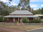
1 Harper Rd Toodyay
fmr Mongers House
Toodyay
Avon Arc
Constructed from 1870, Constructed from 1900
| Type | Status | Date | Documents |
|---|---|---|---|
| Heritage List | Adopted | 01 Dec 2012 | |
| State Register | Registered | 07 Apr 1995 | HCWebsite.Listing+ListingDocument, HCWebsite.Listing+ListingDocument |
| Type | Status | Date | Documents |
|---|---|---|---|
| (no listings) |
| Type | Status | Date | Grading/Management | |
|---|---|---|---|---|
| Category | ||||
| Municipal Inventory | Adopted | 27 Aug 1998 | Category 2 | |
| Register of the National Estate | Permanent | 30 Jun 1992 | ||
| Anglican Church Inventory | Adopted | |||
| Classified by the National Trust | Classified | 03 Mar 1992 | ||
| Library Id | Title | Medium | Year Of Publication |
|---|---|---|---|
| 1311 | Butterly House Toodyay WA : Conservation Plan | Heritage Study {Cons'n Plan} | 1996 |
| 3494 | Butterly House Harper Road Toodyay-Conservation Works Final Report | Heritage Study {Other} | 1998 |
| 4217 | Report on Butterly House Formerly Monger's Cottage Lot 11, Harper Road Toodyay | Report | 1992 |
Individual Building or Group
| Epoch | General | Specific |
|---|---|---|
| Original Use | RESIDENTIAL | Single storey residence |
| Original Use | FARMING\PASTORAL | Cottage |
| Present Use | VACANT\UNUSED | Vacant\Unused |
| Other Use | COMMERCIAL | Bank |
| Style |
|---|
| Victorian Georgian |
| Type | General | Specific |
|---|---|---|
| Roof | TIMBER | Shingle |
| Roof | METAL | Corrugated Iron |
| Wall | BRICK | Common Brick |
| Other | METAL | Pressed Metal |
| General | Specific |
|---|---|
| DEMOGRAPHIC SETTLEMENT & MOBILITY | Settlements |
This information is provided voluntarily as a public service. The information provided is made available in good faith and is derived from sources believed to be reliable and accurate. However, the information is provided solely on the basis that readers will be responsible for making their own assessment of the matters discussed herein and are advised to verify all relevant representations, statements and information.
Constructed from 1910, Constructed from 1870
The building has historic value through its association with the settlement and development of the town of Toodyay. The place has social value through its association with early settlers, the Monger family and the Western Australian Bank. The social value of the place to the community of Toodyay is demonstrated by its acquisition by the Shire of Toodyay and its subsequent restoration and use by the community. The building has aesthetic value as it makes a valuable contribution to the Stirling Terrace streetscape.
Red brick single storey dwelling with iron roof with double hip to rear and single hip to the front. The building is surrounded by an iron bullnose verandah supported on timber posts with Colonial style timber panels. The front elevation presents a symmetrical facade with centrally placed door and flanking French windows. Brick work is laid in Flemish and English bonds with tuck pointing.
J.G.C. Carr bought the property in 1860. Later, John Henry Monger built the house in which his son, Charles Samuel monger, lived. In 1889 the Western Australian Bank occupied the building for use as a banking premises. This was the first bank in the town of Toodyay. In 1898, the bank moved into a newly built premises and Charles Monger resumed residency. In about 1910 Mr. & Mrs. (nee Emma Monger) Augustus Butterly bought the property and carried out extensive remodelling of the place. Butterly family members left the house in about 1980 and the Toodyay Shire acquired it. It is currently (2010) leased to the Butterly Cottages Association Inc.
Integrity: Moderate Authenticity: High
Good
| Owner | Category |
|---|---|
| Shire of Toodyay | Local Gov't |
This information is provided voluntarily as a public service. The information provided is made available in good faith and is derived from sources believed to be reliable and accurate. However, the information is provided solely on the basis that readers will be responsible for making their own assessment of the matters discussed herein and are advised to verify all relevant representations, statements and information.
11-13 Harper Rd Toodyay
Cnr Charles St GPS: 0448684 6508990 Mi States: 11 Nottingham Rd- property may face Harper Rd but the house faces Nottingham Rd BDD 19-12-12
Griffin's Cottage
Toodyay
Avon Arc
Constructed from 1857
| Type | Status | Date | Documents |
|---|---|---|---|
| Heritage List | Adopted | 01 Dec 2012 |
| Type | Status | Date | Documents |
|---|---|---|---|
| (no listings) |
| Type | Status | Date | Grading/Management | |
|---|---|---|---|---|
| Category | ||||
| Municipal Inventory | Adopted | 27 Aug 1998 | Category 3 | |
Individual Building or Group
| Epoch | General | Specific |
|---|---|---|
| Present Use | RESIDENTIAL | Single storey residence |
| Original Use | RESIDENTIAL | Single storey residence |
| Type | General | Specific |
|---|---|---|
| Roof | METAL | Corrugated Iron |
| Wall | BRICK | Common Brick |
| General | Specific |
|---|---|
| DEMOGRAPHIC SETTLEMENT & MOBILITY | Settlements |
This information is provided voluntarily as a public service. The information provided is made available in good faith and is derived from sources believed to be reliable and accurate. However, the information is provided solely on the basis that readers will be responsible for making their own assessment of the matters discussed herein and are advised to verify all relevant representations, statements and information.
Constructed from 1857
The place has historic value as it demonstrates the development in the town in the 1870's. The place has aesthetic value for its contribution to the streetscape of Stirling Terrace.
A single storey brick property with a stone cellar and red iron hipped roof. The windows are multi-paned timber windows. There is a single storey extension of brick with iron vented gablet and hipped roof. The brickwork has been lime-washed and a verandah fully encloses the lower section.
On 31 October 1864 this lot was allotted to James Griffin. Julia Harper, Rev. Charles Harper's daughter, lived in this cottage before her death in 1889. Julia Harper assisted her father in teaching children at 'Braybrook' and had responsibility for the Sunday School.
Integrity: High Authenticity: Medium
Good
| Owner | Category |
|---|---|
| Watkins | Other Private |
This information is provided voluntarily as a public service. The information provided is made available in good faith and is derived from sources believed to be reliable and accurate. However, the information is provided solely on the basis that readers will be responsible for making their own assessment of the matters discussed herein and are advised to verify all relevant representations, statements and information.
17 Harper Rd Toodyay
GPS: 0448650 6508967
Toodyay
Avon Arc
Constructed from 1860
| Type | Status | Date | Documents |
|---|---|---|---|
| Heritage List | Adopted | 01 Dec 2012 |
| Type | Status | Date | Documents |
|---|---|---|---|
| (no listings) |
| Type | Status | Date | Grading/Management | |
|---|---|---|---|---|
| Category | ||||
| Municipal Inventory | Adopted | 27 Aug 1998 | Category 3 | |
Individual Building or Group
| Epoch | General | Specific |
|---|---|---|
| Present Use | RESIDENTIAL | Single storey residence |
| Original Use | RESIDENTIAL | Single storey residence |
| Type | General | Specific |
|---|---|---|
| Roof | METAL | Corrugated Iron |
| Wall | EARTH | Adobe {Mud Brick} |
| General | Specific |
|---|---|
| DEMOGRAPHIC SETTLEMENT & MOBILITY | Settlements |
This information is provided voluntarily as a public service. The information provided is made available in good faith and is derived from sources believed to be reliable and accurate. However, the information is provided solely on the basis that readers will be responsible for making their own assessment of the matters discussed herein and are advised to verify all relevant representations, statements and information.
Constructed from 1860
The place has historic value for its associations with early settler Matthew Doust. It has aesthetic value as a representative example of a modest cottage built in the 1860's and for its contribution to the townscape of Toodyay.
An extended mudbrick cottage constructed upon a stone plinth with a hipped iron roof and asbestos panelled extension. Extensive range of casement windows to front elevation.
In October 1857 a pensioner guard was allocated this lot. In December 1875 Matthew Doust acquired the property. He had his beginnings in carting when he bought horses from Daniel Connor and began carting wool, sandalwood, shingles and flour to Guildford and Fremantle the loading provisions for Toodyay.
Integrity: Medium-High Authenticity: Low
Poor
| Owner | Category |
|---|---|
| Wlazlowski | Other Private |
This information is provided voluntarily as a public service. The information provided is made available in good faith and is derived from sources believed to be reliable and accurate. However, the information is provided solely on the basis that readers will be responsible for making their own assessment of the matters discussed herein and are advised to verify all relevant representations, statements and information.

7 Henry St Toodyay
GPS: 0449563 6508670
Residence
Toodyay
Avon Arc
Constructed from 1894
| Type | Status | Date | Documents |
|---|---|---|---|
| Heritage List | Adopted | 01 Dec 2012 |
| Type | Status | Date | Documents |
|---|---|---|---|
| (no listings) |
| Type | Status | Date | Grading/Management | |
|---|---|---|---|---|
| Category | ||||
| Municipal Inventory | Adopted | 27 Aug 1998 | Category 2 | |
| Classified by the National Trust | Recorded | 07 Jun 1977 | ||
Individual Building or Group
| Epoch | General | Specific |
|---|---|---|
| Present Use | RESIDENTIAL | Two storey residence |
| Original Use | HEALTH | Hospital |
| Type | General | Specific |
|---|---|---|
| Roof | METAL | Corrugated Iron |
| Wall | BRICK | Common Brick |
| Wall | STONE | Other Stone |
| General | Specific |
|---|---|
| SOCIAL & CIVIC ACTIVITIES | Community services & utilities |
This information is provided voluntarily as a public service. The information provided is made available in good faith and is derived from sources believed to be reliable and accurate. However, the information is provided solely on the basis that readers will be responsible for making their own assessment of the matters discussed herein and are advised to verify all relevant representations, statements and information.
Constructed from 1894, Constructed from 1892
The former hospital has social value as it was the first and only purpose built hospital in Toodyay and has associations with health services over the short period it was operational. The place has aesthetic value for its contribution to the streetscape of the town of Toodyay and is a fine example of Wroth & Lloyd construction.
Two storey structure of brick, stone and iron construction with tuck pointing. Verandahs to both storeys with simple Colonial criss cross timber balustrading to the upper level, open to the ground level. Stone construction to the ground level with brick dressings to windows and doors and quoning to the walls. Timber framed casement windows and French doors.
In the mid 1880's the poor condition of the government buildings in Toodyay resulted in renovation works, including the conversion of the old school (formerly the policeman's quarters and the 'depot') into a hospital. The infirmary at the time only accommodated 10 men and the need for a general public hospital had been a concern for years. The former school was renovated and equipped as a hospital due to a typhoid outbreak amongst the railway workers at Clackline. In 1892 construction commenced on this new hospital but stopped and then recommenced in 1894. In 1901 the Newcastle Board of Health was formed and Dr. Lovegrove, the principal medical officer for WA and President of the Central Board of health investigated the cost of running the Newcastle Hospital. He concluded that building the hospital was premature and the doctor was not required. In 1902 he ordered the hospital closed and most of the fittings and fixtures were sent to a new hospital in Katanning. Several accidents and illnesses highlighted the need for the hospital in Toodyay and after Dr. Mayhew agreed to 'live-in', the hospital reopened. Dr. mayhew retired and left the area in 1904. During a typhoid epidemic in 1906 a wing of the hospital re-opened. In 1910 the State Government and Newcastle Roads Board jointly took over maintenance of the hospital. The hospital remained operational until prior to World War II when it became an outpatient facility until a resident doctor arrived in 1952.
Integrity: Low-Medium Authenticity: Medium
Good
| Owner | Category |
|---|---|
| Mattin | Other Private |
This information is provided voluntarily as a public service. The information provided is made available in good faith and is derived from sources believed to be reliable and accurate. However, the information is provided solely on the basis that readers will be responsible for making their own assessment of the matters discussed herein and are advised to verify all relevant representations, statements and information.
Jubilee St Toodyay
GPS: 0448542 6509573 (Recreation Grounds) 0448625 6509557 (Coach works)
Donegan's Cottage
Parker's Cottage
Toodyay
Avon Arc
Constructed from 1890
| Type | Status | Date | Documents |
|---|---|---|---|
| Heritage List | Adopted | 01 Dec 2012 |
| Type | Status | Date | Documents |
|---|---|---|---|
| RHP - To be assessed | Current | 07 Apr 2022 |
| Type | Status | Date | Grading/Management | |
|---|---|---|---|---|
| Category | ||||
| Municipal Inventory | Adopted | 27 Aug 1998 | Category 2 | |
Individual Building or Group
| Epoch | General | Specific |
|---|---|---|
| Original Use | SOCIAL\RECREATIONAL | Grandstand |
| Present Use | SOCIAL\RECREATIONAL | Other |
| Original Use | SOCIAL\RECREATIONAL | Other |
| Present Use | SOCIAL\RECREATIONAL | Grandstand |
| Type | General | Specific |
|---|---|---|
| Wall | BRICK | Common Brick |
| Roof | METAL | Corrugated Iron |
| Wall | TIMBER | Weatherboard |
| General | Specific |
|---|---|
| SOCIAL & CIVIC ACTIVITIES | Sport, recreation & entertainment |
This information is provided voluntarily as a public service. The information provided is made available in good faith and is derived from sources believed to be reliable and accurate. However, the information is provided solely on the basis that readers will be responsible for making their own assessment of the matters discussed herein and are advised to verify all relevant representations, statements and information.
Constructed from 1886
The place has historic value for its associations with the development of recreational facilities in Toodyay and leading identities in that endeavour. It also has associations with the development of industry and housing in Toodyay in the late 1800s. The site has historic value as the location of a former aboriginal burial ground. The site has research value as it has potential to contain subsurface archaeological remains.
Historical recreation ground with associated seating stands and clubhouse facilities. Also used as show ground with associated animal enclosures.
B.D. Clarkson first came to the Avon Valley in 1860 in the company of the Dempsters and Charles Harper Jnr. His father (Michael Clarkson) held pastoral leases over 'Mt Anderson' and in 1866 was Secretary of the Agricultural Society. In 1867 B.D. Clarkson married Isabella Lukin and left the district to manage his uncle's pastoral station in the Champion Bay district. During the 1880's he was also on the Board of Education, a Justice of the Peace and was voted to the Road Board in 1884. The beginnings of North Newcastle began in 1886 when B.D. Clarkson loaned land on the north bank of the river to the cricket club after the depot pitch was no longer suitable. Cricket was very popular at the time and the Aboriginal team from New Norcia dominated the scene. The Toodyay cricketers and footballers combined to form the Athletics Club and purchased the ground from Clarkson. Within a few years they raised money to build a pavilion. The anticipation of the railway extension to Toodyay in 1887, Clarkson surveyed land around the recreation ground into one acre blocks and sold them for twenty pounds each. This year the recreation ground was the final venue of the procession marching down the main street to celebrate Queen Victoria's Golden Jubilee. In 1888, C.G. Ellery the bookmaker erected three cottages on the lots and established fruit trees and gardens around them. Donegan also bought some land and in 1891 when he proposed planting a vineyard and Aboriginal person informed him that the site was a burial ground and should not be disturbed. In 1890 the Toodyay Agricultural Show held their annual event at the recreation ground. Also in this year Kingston and Best, blacksmiths and wheelwrights, established a saw mill and coach building works near here. It was a prosperous business employing twelve men, motorising the operation and making new carriages for most of the leading farmers in the district. It was the town's second manufacturing industry after Hasell's brickworks. The mill has been demolished. In 1896 the recreation grounds were enlarged and fenced and a large pavilion was erected for indoor exhibits. In 1916 the burial site was gazetted as an aboriginal cemetery. In 1951, the new Exhibition Hall was constructed and in 1960 it was extended and named in honour of Sir Ernest Lee Steere. In 1969, the Pavilion Change Rooms were erected. In 1994, the Toodyay Agricultural society removed the old Scout Hall located at the Showgrounds.
Integrity: High Authenticity: Medium
| Owner | Category |
|---|---|
| Shire of Toodyay | Local Gov't |
This information is provided voluntarily as a public service. The information provided is made available in good faith and is derived from sources believed to be reliable and accurate. However, the information is provided solely on the basis that readers will be responsible for making their own assessment of the matters discussed herein and are advised to verify all relevant representations, statements and information.
4 Jubilee St Toodyay
GPS: 0448546 6509617
Toodyay
Avon Arc
Constructed from 1890
| Type | Status | Date | Documents |
|---|---|---|---|
| Heritage List | Adopted | 01 Dec 2012 |
| Type | Status | Date | Documents |
|---|---|---|---|
| (no listings) |
| Type | Status | Date | Grading/Management | |
|---|---|---|---|---|
| Category | ||||
| Municipal Inventory | Adopted | 27 Aug 1998 | Category 3 | |
Individual Building or Group
| Epoch | General | Specific |
|---|---|---|
| Present Use | RESIDENTIAL | Single storey residence |
| Original Use | RESIDENTIAL | Single storey residence |
| Style |
|---|
| Victorian Georgian |
| Type | General | Specific |
|---|---|---|
| Roof | METAL | Corrugated Iron |
| Wall | BRICK | Common Brick |
| General | Specific |
|---|---|
| DEMOGRAPHIC SETTLEMENT & MOBILITY | Settlements |
This information is provided voluntarily as a public service. The information provided is made available in good faith and is derived from sources believed to be reliable and accurate. However, the information is provided solely on the basis that readers will be responsible for making their own assessment of the matters discussed herein and are advised to verify all relevant representations, statements and information.
Constructed from 1890
The place has historic value as a good representative example of development in Toodyay in the 1890's. The place has aesthetic value for its demonstration of original construction methods and for its contribution to the streetscape.
A symmetrical small single storey brick and iron cottage with a front verandah with bell cast canopy, lattice balustrading and centrally placed steps. The brickwork is laid in Flemish bond creating a polychrome pattern and English garden wall bond to side elevation. The window and door arches consist of two rows of header bricks, one row each of dark and light bricks. The end voussoirs are stretcher bricks of the darker colour. An extension to rear is brick and iron elevation with a skillion roof. Very poor condition.The building has been stabilised at the side. There is evidence of brickwork damage and the loss of verandah balustrades and the roof requires attention. The windows are boarded up with protective grills.
This is a good representative example of one of the many cottages of its type built in Toodyay in the period of expansion in the 1890's.
Integrity: Medium Authenticity: High
Very Poor
| Owner | Category |
|---|---|
| Somers | Other Private |
This information is provided voluntarily as a public service. The information provided is made available in good faith and is derived from sources believed to be reliable and accurate. However, the information is provided solely on the basis that readers will be responsible for making their own assessment of the matters discussed herein and are advised to verify all relevant representations, statements and information.
366 Julimar Rd Toodyay
4 kms E of Toodyay on N side of Julimar Rd. GPS: 0446103 6511620
Dawson's Cottage
Monkey Cottage
Toodyay
Avon Arc
Constructed from 1854 to 1865
| Type | Status | Date | Documents |
|---|---|---|---|
| Heritage List | Adopted | 01 Dec 2012 | |
| State Register | Registered | 27 Nov 1998 | HCWebsite.Listing+ListingDocument, HCWebsite.Listing+ListingDocument |
| Type | Status | Date | Documents |
|---|---|---|---|
| (no listings) |
| Type | Status | Date | Grading/Management | |
|---|---|---|---|---|
| Category | ||||
| Municipal Inventory | Adopted | 27 Aug 1998 | Category 2 | |
| Library Id | Title | Medium | Year Of Publication |
|---|---|---|---|
| 7740 | Report on Hassell's cottage, Toodyay: conservation works report. | Conservation works report | 2006 |
Individual Building or Group
| Epoch | General | Specific |
|---|---|---|
| Original Use | RESIDENTIAL | Single storey residence |
| Original Use | INDUSTRIAL\MANUFACTURING | Other |
| Present Use | VACANT\UNUSED | Vacant\Unused |
| Style |
|---|
| Victorian Tudor |
| Type | General | Specific |
|---|---|---|
| Wall | STONE | Local Stone |
| Roof | METAL | Corrugated Iron |
| Wall | BRICK | Common Brick |
| General | Specific |
|---|---|
| PEOPLE | Early settlers |
This information is provided voluntarily as a public service. The information provided is made available in good faith and is derived from sources believed to be reliable and accurate. However, the information is provided solely on the basis that readers will be responsible for making their own assessment of the matters discussed herein and are advised to verify all relevant representations, statements and information.
Constructed from 1854
The place has historic value as one of four remaining structures of the original Toodyay township and for its association with George Hasell, a prominent builder in the region. The brick kiln is a rare and unusual example of its type and period in Western Australia. The cottage has aesthetic value as it demonstrates artistic excellence through the quality of the masonry and for its contribution to the streetscape.
Single storey stone brick and former dwelling, now in ruins. No roof, windows or doors and supported by internal metal bracing bolted through the main elevations. holes in elevations may be evidence of previous stabilisation works. Stonework has been re-pointed in places. The original cottage was extended to the rear, the brick quoining marking the point of the original rear elevation. Windows and door openings have red brick dressings set in a rounded arch. Remnants of a red brick chimney.
'Hasell's Cottage' is the ruin of a Victorian Tudor style cottage built by George Henry Hasell in two stages. This is a two room, single-storey building made of a mixture of convict depot bricks, Hasell's own bricks and cut stone. It was constructed around the end of 1854. The building was roofed with corrugated iron and was one of the first buildings in the district to use this roofing material. A brick kiln located about 100 metres from the cottage was constructed by Hasell around 1855. In 1865 a single-storey extension with a cellar was added by Hasell. Hasell was a prominent builder of the district and was responsible for a number of buildings now recognised for their heritage value. Hasell was an Irish convict convicted of cattle stealing. He was given his Ticket Of Leave the day after he arrived in the Swan River Colony and was sent to the Toodyay Convict Depot to work on its construction. He was granted his conditional pardon in 1854 when he married and built this dwelling. Members of the family remained in the house until 1900.
Integrity: High Authenticity: High
Poor-Ruins
| Owner | Category |
|---|---|
| C & C Ricketts | Other Private |
This information is provided voluntarily as a public service. The information provided is made available in good faith and is derived from sources believed to be reliable and accurate. However, the information is provided solely on the basis that readers will be responsible for making their own assessment of the matters discussed herein and are advised to verify all relevant representations, statements and information.
4-6 Mt Anderson St Toodyay
GPS: 0448994 6509442
Donnelly's
Mary Lees'
Toodyay
Avon Arc
Constructed from 1890
| Type | Status | Date | Documents |
|---|---|---|---|
| Heritage List | Adopted | 01 Dec 2012 |
| Type | Status | Date | Documents |
|---|---|---|---|
| (no listings) |
| Type | Status | Date | Grading/Management | |
|---|---|---|---|---|
| Category | ||||
| Municipal Inventory | Adopted | 27 Aug 1998 | Category 3 | |
Individual Building or Group
| Epoch | General | Specific |
|---|---|---|
| Present Use | RESIDENTIAL | Single storey residence |
| Original Use | RESIDENTIAL | Single storey residence |
| Style |
|---|
| Victorian Georgian |
| Type | General | Specific |
|---|---|---|
| Roof | METAL | Corrugated Iron |
| Wall | BRICK | Common Brick |
| General | Specific |
|---|---|
| DEMOGRAPHIC SETTLEMENT & MOBILITY | Settlements |
This information is provided voluntarily as a public service. The information provided is made available in good faith and is derived from sources believed to be reliable and accurate. However, the information is provided solely on the basis that readers will be responsible for making their own assessment of the matters discussed herein and are advised to verify all relevant representations, statements and information.
Constructed from 1890
The place has historic value as a good representative example of development in Toodyay in the 1890's. The place has historic value for its associations with the Lee and Donnelly families. The place has aesthetic value for its demonstration of original construction methods and for its contribution to the streetscape.
A single storey brick and iron cottage situated on a raised plot with hipped roof and brick chimneys. there are extensive verandahs with 3-bar timber fencing balustrade and timber posts. Brickwork is painted. Timber framed sash and casement windows. Weatherboard extension towards the rear of the property. Built on brick piers in part taking into account the changing topographical levels of the plot.
The cottage was constructed in Toodyay in a period of expansion in the 1890's. Mary Lee lived there before selling to William Lee. In the late 1950's Arthur Donnelly moved into the house after having arrived in Australia in the early 1930's. His sons built the side verandahs.
Integrity: Medium-High Authenticity: Low-Medium
Good
| Owner | Category |
|---|---|
| Stanford | Other Private |
This information is provided voluntarily as a public service. The information provided is made available in good faith and is derived from sources believed to be reliable and accurate. However, the information is provided solely on the basis that readers will be responsible for making their own assessment of the matters discussed herein and are advised to verify all relevant representations, statements and information.
Northam Toodyay Road Toodyay
Northam Toodyay Road
Toodyay
Avon Arc
| Type | Status | Date | Documents |
|---|---|---|---|
| (no listings) |
| Type | Status | Date | Documents |
|---|---|---|---|
| RHP - Does not warrant assessment | Current | 30 Sep 2016 |
| Type | Status | Date | Grading/Management | |
|---|---|---|---|---|
| Category | ||||
| (no listings) | ||||
• The place is representative of the type of timber bridges constructed in the Wheatbelt during the 1940s and the subsequent ‘refurbishment’ of most of these in the twentieth-century
• The place may represent the use of sustenance labour for bridge construction in the Wheatbelt in the 1940s
• The place may represent the work of local governments in road bridge construction in the Wheatbelt
Bridge 363, Tinks Bridge, Northam-Toodyay Road, Toodyay comprises a road bridge with a timber superstructure on concrete abutments. The bridge measures 6 metres in length, and 9 metres in overall width. The bridge was constructed in 1940 and a concrete overlay was applied in 2000. Steel and iron guard rails line both sides.
Toodyay did not reap a direct benefit from the mining boom of the 1960s and 1970s but in the 1960s tourism had begun to emerge as a subsidiary industry for the Toodyay is situated in the Wheatbelt region of Western Australia. The Wheatbelt wraps around the north and east side of the metropolitan area, includes the Avon Valley, and extends from Jurien Bay in the northwest, Lake King in the southeast, and the Shire of Yilgarn in the east. The area is predominantly mixed farming, namely wheat and sheep. Agricultural settlement of the region began in the Avon Valley in 1831 and, although a route from Perth to Albany was surveyed in 1830 it remained a sand track in the 1840s. Toodyay (then Newcastle) was occupied by the British for agricultural purposes in 1836, albeit several kilometres downstream from the current location. Development was slow until, in 1850, the first shipload of convicts arrived in the Colony providing the needed labour force to undertake public works. In 1851 a convict depot was established at Toodyay, at the site where the town stands today, with the town relocating there in 1859. In 1884/5 the railway from Guildford to York was completed, and the line to Toodyay in 1888. By the 1880s the Moore and Avon River valleys comprised largely established wheat and sheep farmers. However, the remainder of the Wheatbelt saw mainly seasonal use with scattered isolated homesteads the norm. With the gold boom in the 1890s the Toodyay area prospered being near the route to the eastern goldfields and hence a source of provisions for those enroute to the goldfields. Agriculture diversified and in 1910 the name of the town was changed to Toodyay. Despite many men from the area leaving to join up in WWI the area continued to be successful in agricultural production. Post-WWI agricultural production continued to increase albeit suffering some setbacks during the Depression as seen elsewhere. Sustenance work is likely to have been undertaken in the area though which projects were specifically part of this program are not known at this time. Many of the smaller settlements in the area did not survive the Depression and in 1934 a major flood hit Toodyay with many roads and rail bridges impacted. According to the data held by Main Roads (Wheatbelt) Bridge 363, Tinks Bridge, Northam-Toodyay Road, Toodyay was constructed in 1940. Following WWII the region saw increased economic growth and stability and both the State and local governments invested in infrastructure. Toodyay was linked to the state electricity grid and scheme water during this period. The Road Board became the Shire of Toodyay in 1961. region. In the 1960s the railway was upgraded to standard gauge and the new Avon Valley line was opened and a new station constructed at Toodyay. The 1970s saw a decline in the rural economy but small ‘hobby farms’ became popular and tourism was further promoted to supplement the local economy.
Historic site
| Epoch | General | Specific |
|---|---|---|
| Original Use | Transport\Communications | Road: Bridge |
| Present Use | Transport\Communications | Road: Bridge |
| Type | General | Specific |
|---|---|---|
| Other | CONCRETE | Other Concrete |
| Other | TIMBER | Other Timber |
| Other | METAL | Other Metal |
This information is provided voluntarily as a public service. The information provided is made available in good faith and is derived from sources believed to be reliable and accurate. However, the information is provided solely on the basis that readers will be responsible for making their own assessment of the matters discussed herein and are advised to verify all relevant representations, statements and information.
3 Oddfellow St Toodyay
Toodyay
Avon Arc
Constructed from 1898
| Type | Status | Date | Documents |
|---|---|---|---|
| Heritage List | Adopted | 01 Dec 2012 |
| Type | Status | Date | Documents |
|---|---|---|---|
| (no listings) |
| Type | Status | Date | Grading/Management | |
|---|---|---|---|---|
| Category | ||||
| Municipal Inventory | Adopted | 27 Aug 1998 | Category 3 | |
26408 Toodyay Townsite
Individual Building or Group
| Epoch | General | Specific |
|---|---|---|
| Present Use | RESIDENTIAL | Single storey residence |
| Original Use | RESIDENTIAL | Single storey residence |
| Style |
|---|
| Victorian Georgian |
| Type | General | Specific |
|---|---|---|
| Roof | METAL | Corrugated Iron |
| Wall | BRICK | Common Brick |
| General | Specific |
|---|---|
| DEMOGRAPHIC SETTLEMENT & MOBILITY | Settlements |
This information is provided voluntarily as a public service. The information provided is made available in good faith and is derived from sources believed to be reliable and accurate. However, the information is provided solely on the basis that readers will be responsible for making their own assessment of the matters discussed herein and are advised to verify all relevant representations, statements and information.
Constructed from 1890
The site has historic value for its associations with pensioner guard David Gailey and the Oddfellows. The place has aesthetic value for its contribution to the streetscape of the town of Toodyay.
A single storey brick and iron dwelling with hipped roof and verandah. There is a densely planted front garden which made assessment difficult.
Lot S7 was allotted to David Gailey on 12 January 1861. The Manchester Unity Order of Oddfellows bought this portion of Gailey's pensioner lot with James Martin, the blacksmith, having the remaining portion. The railways resumed much of the land for the railway from Toodyay to Bolgart c.1908.
Integrity: High Authenticity: Medium
Good
| Owner | Category |
|---|---|
| Paterson | Other Private |
This information is provided voluntarily as a public service. The information provided is made available in good faith and is derived from sources believed to be reliable and accurate. However, the information is provided solely on the basis that readers will be responsible for making their own assessment of the matters discussed herein and are advised to verify all relevant representations, statements and information.
Pelham St Toodyay
GPS: Spill Weir 0449355 6508704 Main reserve 0449448 6508370
Toodyay
Avon Arc
| Type | Status | Date | Documents |
|---|---|---|---|
| Heritage List | Adopted | 01 Dec 2012 |
| Type | Status | Date | Documents |
|---|---|---|---|
| (no listings) |
| Type | Status | Date | Grading/Management | |
|---|---|---|---|---|
| Category | ||||
| Municipal Inventory | Adopted | 27 Aug 1998 | Category 2 | |
Urban Park
| Epoch | General | Specific |
|---|---|---|
| Present Use | PARK\RESERVE | Park\Reserve |
| Original Use | MILITARY | Other |
| General | Specific |
|---|---|
| OUTSIDE INFLUENCES | World Wars & other wars |
This information is provided voluntarily as a public service. The information provided is made available in good faith and is derived from sources believed to be reliable and accurate. However, the information is provided solely on the basis that readers will be responsible for making their own assessment of the matters discussed herein and are advised to verify all relevant representations, statements and information.
Constructed from 1900 to 1940
The site has historical value due to its association with World War II training and defences. The site has aesthetic value for its contribution to the Toodyay townsite.
A York Gum and Jam Tree woodland and remnants of former military occupation, including army tunnels, concrete spill weir, rifle range, the James Drummond Memorial Nature Garden with lookout, picnic area and the water reservoir/water tanks.
This site was associated with General MacArthur's headquarters during World War II, under the command of Lieutenant General Gordon-Bennett. It was used, in part, as a communication post for the Signal Corps.
None
| Owner | Category |
|---|---|
| Shire of Toodyay | Local Gov't |
This information is provided voluntarily as a public service. The information provided is made available in good faith and is derived from sources believed to be reliable and accurate. However, the information is provided solely on the basis that readers will be responsible for making their own assessment of the matters discussed herein and are advised to verify all relevant representations, statements and information.
5 Piesse St Toodyay
Connor's Restaurant
Toodyay
Avon Arc
Constructed from 1870
| Type | Status | Date | Documents |
|---|---|---|---|
| Heritage List | Adopted | 01 Dec 2012 |
| Type | Status | Date | Documents |
|---|---|---|---|
| (no listings) |
| Type | Status | Date | Grading/Management | |
|---|---|---|---|---|
| Category | ||||
| Municipal Inventory | Adopted | 27 Aug 1998 | Category 3 | |
04128 Stirling Terrace Streetscape Group
Individual Building or Group
| Epoch | General | Specific |
|---|---|---|
| Original Use | RESIDENTIAL | Single storey residence |
| Present Use | COMMERCIAL | Restaurant |
| Style |
|---|
| Victorian Georgian |
| Type | General | Specific |
|---|---|---|
| Wall | BRICK | Common Brick |
| Roof | METAL | Corrugated Iron |
| General | Specific |
|---|---|
| PEOPLE | Famous & infamous people |
This information is provided voluntarily as a public service. The information provided is made available in good faith and is derived from sources believed to be reliable and accurate. However, the information is provided solely on the basis that readers will be responsible for making their own assessment of the matters discussed herein and are advised to verify all relevant representations, statements and information.
Constructed from 1870
The place has historic value through its associations with Daniel Connor, a significant identity in the history of the development of Toodyay town and district. The place has historic value as it is associated with the settlement and development of the Toodyay townsite. The place has social value as it demonstrates a former way of life through the scale of the dwelling and the size of the rooms. The building has aesthetic value for its contribution to the streetscape.
A single storey painted brick and iron structure with hipped roof, timber framed casement windows. Verandah extends around much of the property with wooden posts and enclosed by a picket style balustrade. The building has been extended to the rear.
Daniel Connor (1832-1898) arrived in the colony as a convict in 1853. Through hard work and a shrewd business sense he became one of the most influential men in Toodyay. Connor purchased significant landholdings throughout the townsite, one of the first of which was Lot 9 on the corner of Stirling Terrace and Piesse Street. On this lot he built the mill and this modest cottage c 1870. Another larger residence was built on the lot in the 1890's. The lot has since been subdivided creating three separate properties. It is likely this cottage was built by George Henry Hassel who undertook many building projects for Connor. The place was at one time used as a bakery and the origin of the alternative name, Ted Chapman, has not been confirmed.
Integrity: Medium Authenticity: Medium
Good
| Owner | Category |
|---|---|
| McKenzie | Other Private |
This information is provided voluntarily as a public service. The information provided is made available in good faith and is derived from sources believed to be reliable and accurate. However, the information is provided solely on the basis that readers will be responsible for making their own assessment of the matters discussed herein and are advised to verify all relevant representations, statements and information.
Railway Rd Toodyay
Toodyay
Avon Arc
Constructed from 1870
| Type | Status | Date | Documents |
|---|---|---|---|
| Heritage List | Adopted | 01 Dec 2012 |
| Type | Status | Date | Documents |
|---|---|---|---|
| RHP - To be assessed | Current | 27 Feb 2004 |
| Type | Status | Date | Grading/Management | |
|---|---|---|---|---|
| Category | ||||
| Municipal Inventory | Adopted | 27 Aug 1998 | Category 1 | |
The place has aesthetic value as a group of buildings of similar style and form located in a picturesque rural setting on the Avon River.
The place has associations with the settlement of the district from the min nineteenth century, and with the development of the wine industry there, which was an important local industry.
The place has associations with Bull and Stevens, who were important regional wine producers and fruit growers in the late nineteenth and early twentieth centuries. This is evidence by the pair's involvement in the establishment of the local and state Vine & Fruit growers Association.
Together, the winery, outbuildings and dwellings, are representative of farms with a vineyard function.
The place is one of the oldest still wineries in the state and continues to operate for its original purpose.
The place is a small group comprising a winery, dwellings and an outbuilding. A new vineyard has been planted at the front (west) of the property. The place is a group of single storey brick buildings. The winery is a double volume building with a cellar. Both the winery and servant quarters have gable cgi roofs and have Flemish bond brickwork with decorative diamond patterns in the gable ends. The other buildings have hipped cgi roofs.
‘In 1859, there were 30 acres of vines in the Toodyay district. On 12 January 1861, sub-Lot 9 was allotted to Thomas Goggins, an Enrolled Pensioner Guard. He and his family left for Adelaide in 1862. By 1864, W Bull in partnership with A Stevens had established Avondale on Sub Lot 9. Viticulture became a prosperous industry in the Toodyay Valley, with the most successful vignerons being Bull and Stevens. In 1885, more land, and 40 acres of vines in 1891. In that year, they produced 5000 gallons of wine, a ton of dessert raisins and 4-5 tons of pudding raisins, although demand still exceeded supply. Stimulated by the gold rushes, they planted another 15 acres of vines in 1892 and built a 60 x 22 ft storeroom. They also grew peaches, apples, oranges and lemons. The place was the showplace of the district where distinguished visitors were escorted, and school concerts and children’s parties took place. In 1893, the first Vine and Fruit growers Association in the colony was formed in Toodyay. Talk of a co-operative winery was opposed by Bull & Stevens who left the Association and formed the Deepdale Farmers and Fruit growers Association. In 1899, Bull & Stevens purchased all the local grapes to make 10,000 gallons of wine and produced 3000 oranges. When a statewide association was formed in 1900, W Bull was one of the committee members.’
High
Good
Individual Building or Group
| Epoch | General | Specific |
|---|---|---|
| Present Use | INDUSTRIAL\MANUFACTURING | Winery |
| Other Use | INDUSTRIAL\MANUFACTURING | Winery |
| Original Use | FARMING\PASTORAL | Cottage |
| Other Use | FARMING\PASTORAL | Servants or Shearers Quarters |
| Style |
|---|
| Vernacular |
| Type | General | Specific |
|---|---|---|
| Roof | METAL | Corrugated Iron |
| Wall | BRICK | Common Brick |
| General | Specific |
|---|---|
| OCCUPATIONS | Manufacturing & processing |
This information is provided voluntarily as a public service. The information provided is made available in good faith and is derived from sources believed to be reliable and accurate. However, the information is provided solely on the basis that readers will be responsible for making their own assessment of the matters discussed herein and are advised to verify all relevant representations, statements and information.
Constructed from 1892, Constructed from 1870
The group of buildings at Avondale have historic value as they demonstrate the development of the property from the 19th to the 21st century. The place is also closely associated with the development of the wine industry in Western Australia and the wine producers, Bull & Stevens. Avondale has aesthetic value as it demonstrates a high level of craftsmanship in the brick designs in the gable walls of the winery. The integrity and authenticity of the buildings on the site is high because of the proportion of original remaining fabric and the ongoing use of the cottage as a residence.
The main house is of red brick construction with pitched gable roof to side swing and hipped roof to main body of the house. The gable roof is enlivened with decorative bargeboards and timber finials. A single storey verandah runs across the main section of the house to the rear with simple Colonial style timber panels. The windows and doors are set within brick arches with a mixture of sash and casement windows. The side extension has been reconstructed, the new brickwork is discernible from the original, enabling the stages of construction to be determined. Brickwork laid in English Garden Wall bond and stretcher bond. Small outhouse to rear of the property of similar design with verandah and polychromatic brick diamond pattern in gable end. Brickwork laid in Flemish bond in alternate dark and light bricks creating a polychromatic pattern to the facades with tuck pointing. Decorative bargeboards. Matching Privy. Further brick outbuilding with iron hipped roof used for garage. The winery is of red brick construction with symmetrical facade and gabled iron roof. Polychromatic brickwork patterns have been integrated into both gable ends, non-matching. Main brickwork has been laid in English Garden Wall bond with tuck pointing. The verandahs to the two main elevations are supported by bush timbers with rear verandah having a timber decked floor. The wine cellar is accessed via an external set of steps. Remnants of a bush timber fence to rear of winery. The servants quarters consist of a mudbrick construction with iron roof and surrounding verandah. Simple design with no decoration.
In 1859 there were 30 acres of vines in the Toodyay district. on 12 January 1861, Sub Lot 9 was allocated to Thomas Goggins, an Enrolled Pensioner Guard who later left for Adelaide. By 1864, W. Bull, in partnership with A. Stevens has established 'Avondale' on Sub Lot 9. Viticulture became a prosperous industry in the Toodyay Valley with the most successful vignerons being Bull and Stevens. Date of Construction : Cottage 1870 Winery 1892 Servants quarters 1892
Integrity: High Authenticity: High
Fair-Good
| Owner | Category |
|---|---|
| Hopkin | Other Private |
This information is provided voluntarily as a public service. The information provided is made available in good faith and is derived from sources believed to be reliable and accurate. However, the information is provided solely on the basis that readers will be responsible for making their own assessment of the matters discussed herein and are advised to verify all relevant representations, statements and information.
Railway, Harper & Telegraph Rds Toodyay
Duidgee park GPS: 0448856 6509124
Nottingham House
Toodyay
Avon Arc
| Type | Status | Date | Documents |
|---|---|---|---|
| (no listings) |
| Type | Status | Date | Documents |
|---|---|---|---|
| (no listings) |
| Type | Status | Date | Grading/Management | |
|---|---|---|---|---|
| Category | ||||
| Municipal Inventory | Adopted | 27 Aug 1998 | Category 4 | |
Historic Site
| Epoch | General | Specific |
|---|---|---|
| Present Use | COMMERCIAL | Shop\Retail Store {single} |
| Original Use | COMMERCIAL | Shop\Retail Store {single} |
| General | Specific |
|---|---|
| OCCUPATIONS | Commercial & service industries |
This information is provided voluntarily as a public service. The information provided is made available in good faith and is derived from sources believed to be reliable and accurate. However, the information is provided solely on the basis that readers will be responsible for making their own assessment of the matters discussed herein and are advised to verify all relevant representations, statements and information.
The site has historic value for its association with the Monger family who were important commercial identities in the establishment of Toodyay. The site has research values as it has potential to contain subsurface archaeological remains.
The site is now Duidgee recreation ground.
John Henry Monger Jnr. bought Lot 1 by the bridge and part of Charles Harper's land and built a two storey warehouse which he sold to his father J.H. Monger. J.H. Monger's brother, Stephen, set up a bakery with his son, Stephen. His other son, Charles Samuel Monger, was the storekeeper at his uncle's store. Charles arranged to be the mail depot and his store dominated trade in Toodyay. After J.H. Snr died in 1867, J.T. continued with the store and stable sand, in 1873 Charles took over the business. In 1891 H. Davey purchased the Freemasons Hotel and also bought Mongers Store. He converted the top floor into living quarters while he renovated the hotel. In about 1945 'Nottingham House' was sold to the Industrial Extracts Factory and used as a boarding house for employees. The store and extensive stable complex downstream were demolished for the construction of the new bridge and roadway.
None
Site Only
This information is provided voluntarily as a public service. The information provided is made available in good faith and is derived from sources believed to be reliable and accurate. However, the information is provided solely on the basis that readers will be responsible for making their own assessment of the matters discussed herein and are advised to verify all relevant representations, statements and information.
Stirling Tce Toodyay
Between Newcastle Bridge & Connor Bridge
Toodyay
Avon Arc
Constructed from 1854
| Type | Status | Date | Documents |
|---|---|---|---|
| (no listings) |
| Type | Status | Date | Documents |
|---|---|---|---|
| RHP - To be assessed | Current | 24 Apr 2020 |
| Type | Status | Date | Grading/Management | |
|---|---|---|---|---|
| Category | ||||
| Municipal Inventory | Adopted | 27 Aug 1998 | P2 | |
| Classified by the National Trust | Recorded | 07 Jun 1977 | ||
26408 Toodyay Townsite
| Library Id | Title | Medium | Year Of Publication |
|---|---|---|---|
| 7426 | Toodyay design guide; Toodyay design guidelines : special design control precincts (Clinton Street Precinct and Stirling Terrace Precinct). | Brochure | 0 |
Precinct or Streetscape
| Epoch | General | Specific |
|---|---|---|
| Present Use | COMMERCIAL | Shop\Retail Store {single} |
| Original Use | COMMERCIAL | Shop\Retail Store {single} |
| General | Specific |
|---|---|
| OCCUPATIONS | Commercial & service industries |
| DEMOGRAPHIC SETTLEMENT & MOBILITY | Settlements |
This information is provided voluntarily as a public service. The information provided is made available in good faith and is derived from sources believed to be reliable and accurate. However, the information is provided solely on the basis that readers will be responsible for making their own assessment of the matters discussed herein and are advised to verify all relevant representations, statements and information.
Constructed from 1860
The Stirling Terrace Streetscape has historic value for its association with the former convict hiring depot, and as the town's main thoroughfare that reflects, through its built structure, the phases of the town's development since the late 1850's to the present. The streetscape with its historic buildings and backdrop of Mount Anderson and mount Pelham has high aesthetic value. The street has potential value as an archaeological site.
Stirling Terrace is the main thoroughfare through the historic town of Toodyay. The road is approximately 1.5km long (from Newcastle Bridge to the Stirling Terrace/Goomalling-Toodyay Road intersection) and runs roughly parallel to the Avon River. The town and main street are nestled in the river valley, overlooked on either side by Mount Pelham and Mount Anderson. The buildings along Stirling Terrace are representative of the development of the town since the 1850's.
The original town of Toodyay (est. 1836) was located downstream of the present town and is now known as West Toodyay. In 1851, following the introduction of convictism in 1850, a convict-hiring depot was established 6km upstream of the town. Construction of the depot was impeded by the need for a better and shorter road. In 1854, a road was constructed using convict labour. The road was called New Road and entered the depot from the east running roughly parallel to the Avon River. The road then crossed the river to continue along the north bank to the township. In 1860, due to recurrent flooding, the town was relocated to the depot. Roads and allotments were surveyed and he new town of Newcastle was gazetted in 1860. Commercial premises (hotels and shops), houses and churches soon appeared along New Road alongside the earlier Pensioner Guard cottages and allotments. In 1905, new Road was renamed Stirling Terrace. In 1910, the name of the town was changed from Newcastle to Toodyay because of postal confusion with Newcastle in NSM, and the old townsite was officially named West Toodyay. In 1890, the town was classified as a Historic Town by the National Trust of Australia (WA). (See the individual buildings for the historic notes and physical descriptions.)
Integrity: High Authenticity: High
Good
This information is provided voluntarily as a public service. The information provided is made available in good faith and is derived from sources believed to be reliable and accurate. However, the information is provided solely on the basis that readers will be responsible for making their own assessment of the matters discussed herein and are advised to verify all relevant representations, statements and information.
Stirling Tce Toodyay
Open space located between Toodyay Memorial Hall and Toodyay Post Office Stirling Terrace
Toodyay
Avon Arc
| Type | Status | Date | Documents |
|---|---|---|---|
| (no listings) |
| Type | Status | Date | Documents |
|---|---|---|---|
| (no listings) |
| Type | Status | Date | Grading/Management | |
|---|---|---|---|---|
| Category | ||||
| (no listings) | ||||
Historic Site
| Epoch | General | Specific |
|---|---|---|
| Original Use | OTHER | Other |
| Present Use | OTHER | Other |
This information is provided voluntarily as a public service. The information provided is made available in good faith and is derived from sources believed to be reliable and accurate. However, the information is provided solely on the basis that readers will be responsible for making their own assessment of the matters discussed herein and are advised to verify all relevant representations, statements and information.
Stirling Tce Toodyay
Toodyay Police Station
Toodyay
Avon Arc
Constructed from 1966
| Type | Status | Date | Documents |
|---|---|---|---|
| (no listings) |
| Type | Status | Date | Documents |
|---|---|---|---|
| RHP - Does not warrant assessment | Current | 28 Sep 2012 |
| Type | Status | Date | Grading/Management | |
|---|---|---|---|---|
| Category | ||||
| (no listings) | ||||
Good
Individual Building or Group
| Epoch | General | Specific |
|---|---|---|
| Other Use | GOVERNMENTAL | Police Station or Quarters |
| Style |
|---|
| Late 20th-Century Perth Regional |
| Type | General | Specific |
|---|---|---|
| Roof | TILE | Terracotta Tile |
| Wall | BRICK | Common Brick |
| General | Specific |
|---|---|
| SOCIAL & CIVIC ACTIVITIES | Law & order |
This information is provided voluntarily as a public service. The information provided is made available in good faith and is derived from sources believed to be reliable and accurate. However, the information is provided solely on the basis that readers will be responsible for making their own assessment of the matters discussed herein and are advised to verify all relevant representations, statements and information.
100 Stirling Tce Toodyay
GPS: 0449466 6509150
Seil Constructions
Toodyay
Avon Arc
Constructed from 1890
| Type | Status | Date | Documents |
|---|---|---|---|
| Heritage List | Adopted | 01 Dec 2012 |
| Type | Status | Date | Documents |
|---|---|---|---|
| (no listings) |
| Type | Status | Date | Grading/Management | |
|---|---|---|---|---|
| Category | ||||
| Municipal Inventory | Adopted | 27 Aug 1998 | Category 3 | |
| Register of the National Estate | Registered | 21 Oct 1980 | ||
04128 Stirling Terrace Streetscape Group
Individual Building or Group
| Epoch | General | Specific |
|---|---|---|
| Original Use | COMMERCIAL | Office or Administration Bldg |
| Present Use | COMMERCIAL | Office or Administration Bldg |
| Type | General | Specific |
|---|---|---|
| Roof | METAL | Corrugated Iron |
| Wall | BRICK | Common Brick |
| General | Specific |
|---|---|
| OCCUPATIONS | Commercial & service industries |
This information is provided voluntarily as a public service. The information provided is made available in good faith and is derived from sources believed to be reliable and accurate. However, the information is provided solely on the basis that readers will be responsible for making their own assessment of the matters discussed herein and are advised to verify all relevant representations, statements and information.
Constructed from 1929, Constructed from 1890
The place has historic value for its associations with the local newspaper. The place has aesthetic value as a fine architectural example of the period which makes a significant contribution to the streetscape of Toodyay.
A rendered brick facade with a moulded parapet above the main shop front. Feature windows are also present. The adjoining premises is very narrow. Originally there was a covered walkway between the shop and residence which is now used as a commercial/retail premises. The hood of original walkway remains as a feature although the access has been blocked up. A partial parapet is also on this section level with the moulding of the main section and adorned with balustrading and finials. The side elevations are face brickwork. A deep skillion roofed verandah extends across both frontages.
From the early 1900's the building was the office and place where the local paper 'The Herald' was printed.
Integriyt: Medium Authenticity: Medium
Good
| Owner | Category |
|---|---|
| Maddox & Payne | Other Private |
This information is provided voluntarily as a public service. The information provided is made available in good faith and is derived from sources believed to be reliable and accurate. However, the information is provided solely on the basis that readers will be responsible for making their own assessment of the matters discussed herein and are advised to verify all relevant representations, statements and information.